
Earth, wind, and fire (not that Earth, Wind & Fire—still active 45 years after the group formed).
No, these are some reflections, going back almost as far as EWF, about my encounters with and experiences of earthquakes, typhoons, and volcanoes (fortunately mostly dormant) around the Ring of Fire.

But first, a summer morning in west Wales
Take 19 July 1984 for example. Steph and I with our two daughters Hannah and Philippa were enjoying a week’s holiday in Pembrokeshire, in west Wales. We’d rented a nice cottage, in Broad Haven, on the coast south of St David’s. As usual, one of us had gone downstairs to make a cup of tea. Steph says it was her; I think it was me. No matter. But just as the tea-maker was about to climb the stairs back to our bedroom (lying in bed, waking up to and enjoying a cup of tea, is one of life’s simple pleasures), we felt the house shake. There had been an earth tremor, hardly worthy of the description ‘earthquake’. But noticeable enough, especially if, like me, you had become sensitized to such tectonic events.
Further north, close to the epicenter on the Llŷn Peninsula, it was much stronger, registering 5.4 on the Richter scale, and was ‘the largest known onshore earthquake to occur in the UK since instrumental measurements began‘. It was felt all over Wales and many parts of England. Chimneys fell from roofs. Liverpool was apparently quite badly hit.
But a Richter 5 quake in the UK is nothing compared to what I have experienced along the ‘Ring of Fire‘.
October 1974
Thursday 3 October started as a normal day. Steph and I had taken the staff bus from our apartment in the Lima district of Miraflores to the International Potato Center (CIP) in La Molina (on the eastern outskirts of the city, and close to the National Agrarian University). We didn’t have our car that day. The government had introduced a gasoline rationing system, and the decal we choose allowed us to drive only over the weekends and on alternate days during the week. This is relevant.
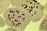
36 chromosomes from a triploid potato variety.
I had arranged to show one of the laboratory technicians how to make chromosome preparations from potatoes. Then, around 09:20, as I was enjoying a cup of coffee, and without any warning, the whole building started to rock and shake backwards and forwards. Clearly this was more than the all-too-frequent earth tremors or temblores that we were ‘used’ to. We all rushed out of the building into the car park. I was still carrying my cup of coffee! And in the car park we all endeavored to remain upright as the ground rolled back and forth, almost a meter at a time, for over two minutes! At La Molina the earthquake (or terremoto) was recorded over 8 on the Richter Scale. Remember of course that the scale is a logarithmic one, so the La Molina earthquake was hundreds of times more powerful than the alarming Llŷn Peninsula version in 1984.
Damage to laboratories and offices at CIP was considerable.


Fortunately there were fewer than 80 deaths and only a couple of thousand injuries around the city, because many people were already in their places of work that were better constructed to withstand an earthquake. However, it was the continual aftershocks (the strongest—at 7.1—felt on Saturday 9 November just before 08:00 as military parade was commencing in downtown Lima) that unnerved everyone. Ever since I have been hypersensitive to any sort of movement of that kind. ‘Did the earth move for you?‘ holds no pleasant connotations.
However, it was in May 1973 that I saw first hand the aftermath of a powerful earthquake. My colleague, Zosimo Huaman and I were away from Lima on a three-week trip to collect native varieties of potatoes from farmers in the Departments of Ancash and La Libertad in central-northern Peru. Just north of Huaraz in the Callejon de Huaylas, and beneath Peru’s highest mountain, Huascarán, lie the remains of two towns, Yungay and Ranrahirca. On 31 May 1970 a huge earthquake triggered an ice and rock landslide from the top of Huascarán, which quickly sped down the mountain obliterating everything in its path. More than 70,000 people lost their lives, and the two towns were destroyed. When we visited just three years later the scene in Yungay was one of utter devastation, with just a few palm trees surviving, and the statue of Christ in the cemetery.


Further north, Zosimo and I had the opportunity of visiting several remote villages on foot. In one (I don’t recall the name) we were welcomed as honored guests, and in my case, as a representative of Queen Elizabeth. After making a short speech of thanks in broken Spanish to about 200 residents gathered in the ‘town hall’, everyone came up and shook my hand. Apparently they had received no help for the government to rebuild their communities nor livelihoods even three years after the earthquake.
Over the course of our three years in Lima, five years in Costa Rica, and almost 19 years in the Philippines, we felt many earth tremors, some stronger than others, but never as awe-inspiring or sphincter-challenging as that in October 1974.
Winds over the Pacific
The Pacific Ocean sees its fair share of tropical storms and stronger. Severe storms in the Pacific are called ‘typhoons’, and the Philippines is unlucky to be battered, on average, by 20 or more each year. Developing way to the east in the open ocean, typhoons head due west towards the Philippines, but often veer northwards and clip the northern tip of the main island of Luzon. Nevertheless, the weather effects of high winds and heavy and prolonged rainfall can affect a much wider area than hit by the ‘eye of the storm’. Some typhoons do head straight for Metro Manila and its 11.8 million population, many living in poverty.
During our almost two decades in Los Baños (working and living at the International Rice Research Institute, IRRI, some 65 km south of Manila, we were hit by just a couple of super typhoons (although after our departure in May 2010 there have been others) but we did feel the effects of many of the typhoons that barreled into the country, disrupting daily life and communications.
 I was away in Laos on 3 November 1995 when Los Baños was hit by Super Typhoon Angela (known as Rosing in the Philippines). I’d departed totally unaware that a typhoon was headed for the Philippines, let alone one that was expected to develop into a ‘super typhoon’. It was only when I tried to phone home during the height of the storm that I realised what I had missed. You can experience something of the force of this typhoon and the unimaginable rainfall that accompanied it in the video below, made by my neighbor and former colleague, Gene Hettel.
At the end of September 2006, the Philippines was hit by Typhoon Milenyo. This was a slow-moving typhoon, dumping a huge amount of rain. In the Los Baños area, most damage was caused by flooding not by the wind. Laguna de Bay rose several meters. The Philippines national genebank in Los Baños was flooded to a depth of several meters because debris washed down the sides of nearby Mt Makiling accumulated created a log jam under a bridge and causing the creek to overflow.
At IRRI Staff Housing, there were several major landslips and the integrity of the Guesthouse and several houses threatened. Creeks around the campus of the University of the Philippines – Los Baños were scoured, and much timber and other vegetation felled.
Since 2010, there have been two super typhoons. In November 2013, Typhoon Haiyan (Yolanda in the Philippines) killed more than 6000 people in the Philippines, and was the strongest storm ever recorded at landfall. Many of the deaths in Tacloban were caused by a storm surge. And in July 2014 (just before I made a visit to IRRI) Super Typhoon Glenda did considerable damage to IRRI’s glasshouses and other buildings. Here is another video by Gene Hettel taken at the height of Super Typhoon Glenda.
Now the fire . . .
I lived on the slopes of two volcanoes for almost 24 years; in Costa Rica, on Volcán Turrialba and in the Philippines, on Mt Makiling. On one occasion I got to the top of Turrialba, driving most of the way with a colleague from CATIE, Dr Andrew King and his wife Heather. That must have been about 1976 or 1977. I almost made it to the top of Makiling, but the final stretch—almost vertical and defeating my arthritic hips—was impossible. Makiling has been dormant for centuries. Turrialba had been inactive for a hundred years but burst into life at the end of October 2014.
To the west of Turrialba stands the Irazú volcano, the highest in Costa Rica at more than 3400 m. It has a perfect crater with a turquoise lake.

The main potato growing area of Costa Rica is found on the slopes of Irazú, and I’ve spent many a long week planting research trials and growing seed potatoes there. After the 1963 eruption, meters of volcanic ash were dumped on the slopes. The soils today are fine, deep and fertile.
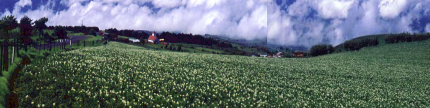
A field of potatoes, var. Atzimba, above Cartago on the slopes of the Irazú volcano in Costa Rica.
Los Baños is surrounded by volcanoes.

Mt Makiling from the IRRI research station and rice fields (looking northwest).

Mt Banahaw and other volcanoes near San Pablo, south and southeast from the IRRI research station.
About 20 km or so as the crow flies almost due west from Los Baños lies the Taal volcano, apparently one of the world’s most dangerous volcanoes.
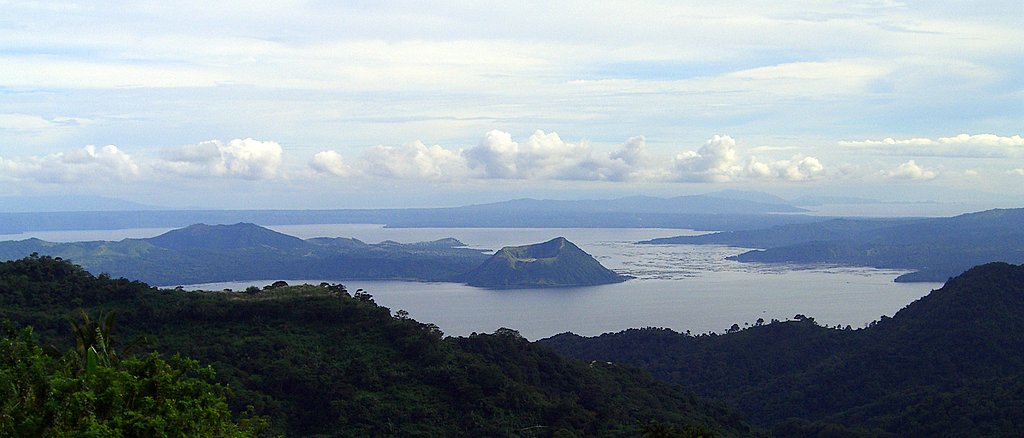
Taal volcano and volcano island from Tagaytay, on the northern rim of a vast caldera.
During our time in the Philippines there was the occasional rumble, but nothing significant since its last major eruption in 1977. Some 400 km southeast from Los Baños and north of the port city of Legazpi is the Mayon volcano, a perfect cone. This is very active and farmers often have to be evacuated when an eruption occurs.
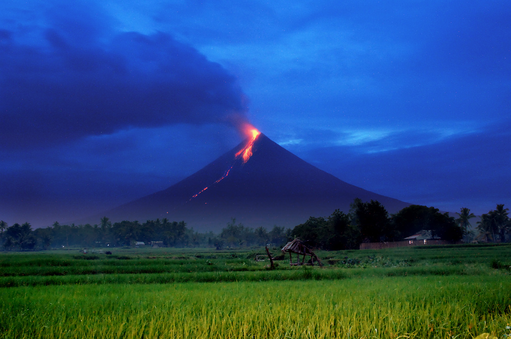
Rice farmer Gloria Miranda’s house at the foot of Mayon Volcano was threatened by lava flows in July 2006. (Photo courtesy of IRRI. Photo by Ariel Javellana).
However, I’ve never been affected directly by a volcanic eruption, only indirectly. Let me explain.
Mt Pinatubo
At the beginning of January 1991 I was invited to interview for the position of Head of the Genetic Resources Center at IRRI. I flew out from Gatwick on British Airways via Hong Kong, after a 13 hour delay in London. After a week at IRRI, I flew back to the UK. Uneventful you may say, and so it was. At the end of January, IRRI offered me the position, and I accepted to join in July that year once I’d completed some teaching and examination commitments at The University of Birmingham.
From mid-March, Mount Pinatubo, a seemingly innocuous volcano north of Manila, began to show signs of seismic activity. In early June there was a series of eruptions, but the massive, climactic eruption of 15 June had a massive effect over a huge area. Ash fell on Los Baños, 150 km to the south.
Fewer than 900 people lost their lives, due in no small part to the evacuations that had been enforced in the days leading up to the 15 June eruption.Nevertheless, the impact on humans, livestock and agriculture in general was immense and pitiful.

On June 15, 1991, this is the eruption plume minutes after the climactic eruption.
Manila airport was closed for days, flights were diverted. This was just a fortnight before I was scheduled to fly to the Philippines. Glued to the news each day I waited to see what the outcome would be. Fortunately I was able to travel on 30 June. But it was touch and go.
Over a year later, when we visited the flight deck of a British Airways 747 out of Hong Kong bound for Manila, the First Officer indicated that flights into the Philippines had to take well-defined flight paths to avoid the lingering ash layers at certain levels in the atmosphere, clearly visible to the naked eye.
A volcano with an unpronounceable name
And when it was time to return to the UK in 2010 on my retirement, it was another volcano, thousands of miles from the Philippines, that almost derailed our travel plans. We had booked to fly back (on our usual Emirates route via Dubai) on Sunday 2 May. But just a fortnight or so earlier, Iceland’s Eyjafjallajökull volcano had erupted; the ever expanding ash cloud effectively closed the airspace over much of Europe for many days.

The estimated ash cloud at 18:00 GMT on 15 April, just a day after the main eruption began.
Once again Fortune smiled on us, and we returned to the UK without delay or incident. Nevertheless, the disruption to air travel, inconvenience to passengers, and not least the economic costs just illustrate how feeble humanity is in the face of the forces of Nature.
Having ‘survived’ numerous earth tremors (or worse) I’m now highly sensitive to anything that smacks of an earthquake. I’m instantly alert. The fugitive impulse kicks in immediately. And you never know, even here in the UK when the next tremor will hit.
The UK is experiencing ever more severe winter storms, with gale-force winds. Not quite on the typhoon scale, but damaging enough, all the same. I hate lying in bed hearing the wind howling around, gusting as though the chimney might be toppled at any moment.
But unless I choose to, I’m unlikely to encounter an active volcano any time soon. Touch wood! However, those Icelandic volcanoes can be highly unpredictable.

Great Post
LikeLike