I don’t particularly like driving. Never have. Especially on the UK’s crowded roads. But it’s a necessity that I live with.
On the other hand, driving around the USA has been a much more pleasant experience. I have enjoyed¹ the road trips (covering at least 12,000 miles) that Steph and I have made around the USA since 2011.
Budget® Car Rental gave us a Jeep Wrangler this year.
Why? Well, for one thing, most of the the routes I have chosen have not been congested, and it’s possible to drive mile upon mile and hardly see another vehicle. In many places, even in the remotest locations, road surfaces are quite good, or indeed, very good. Also, having lived in countries where they drive on the ‘wrong’ side (Peru, Costa Rica, and the Philippines) for almost three decades, driving on the right in the USA doesn’t faze me.
Those who follow my blog, or come across my stories from time to time, will know that I try and illustrate these quite liberally with photos that I have (mostly) taken myself. But on many of our trips across America there are often no places to stop conveniently and take in the landscape.
On a couple of occasions, when we traveled through the redwoods of northern California, or, more recently, worked our way through the Appalachians, for example, Steph held a video camera. But that’s never been a satisfactory solution.
So, earlier this year, I decided to invest in a Nextbase dashcam, which I used during our most recent trip to record the whole nine days. Hours of video to scan, and decide on the best clips. Was it worth it, you might very well ask? I think so, especially as the software bundled with the cam permits me to capture individual frames as images that I can use in the same way as those from my DSLR.
I try to choose routes along scenic byways, where we’ll often see important features in the landscape. During this year’s trip we took in the Delaware Water Gap National Recreation Area along the border between Pennsylvania and New Jersey, as well as the Monongahela National Forest in West Virginia.
The Delaware Water Gap National Recreation Area follows the course of the Delaware River (map), and forms the state line between Pennsylvania and New Jersey. We traveled down the valley on the PA side, northeast to southwest. At the southern end, the Delaware River takes a sharp turn east cutting through a significant mountain ridge.
The Gap at Kittatinny Point in New Jersey
There are a couple of visitors centers. In the north of the area is Dingmans Falls Visitor Center, and the falls close by. This video takes you from the entrance to the Recreation Area in the north, to Dingmans Falls, and south to the Gap, before emerging in New Jersey and looking back westwards to the Gap.
The Monongahela National Forest (19) is one of 26 national forests nationwide.
We’ve been fortunate to pass through several others during previous road trips: Green Mountain/White Mountain (15) in the northeast; Daniel Boone (10) in Kentucky; Allegheny (1) in western Pennsylvania; Black Hills (3) in South Dakota; Shoshone (25) and Bridger-Teton in Wyoming; and Coconino (8) in Arizona; and many more forests and wilderness areas that are not necessarily part of the national forest system.
Monongahela covers a vast area of the ridges and valleys of West Virginia. We traveled southwest down the valleys, but as our destination on that day was Appomattox in central Virginia, we had to keep turning east, climbing and descending ridges in frequent succession.
We stopped at the Seneca Rocks Discovery Center to take a look (from a distance) at the rocks themselves, an enormous quartzite crag, which apparently the only true peak on the east coast.
Criss-crossing these ridges and valleys was where many battles and skirmishes were fought during the Civil War from 1861-1865. It’s hard enough driving over these ridges, never mind tramping mile after mile, hauling wagons with matériel and provisions, ill-clothed and ill-shod, and then having to fight a battle. Awe inspiring!.
Driving across the USA opens one’s eyes to the enormity of the country, the vastness of the landscapes that open up ahead. And on this particular trip, the scale of the challenge to ford rivers, even the ocean, came home to me as we passed over some remarkable bridges, exquisite examples of civil engineering. So, rather than trying to describe each of the bridges that caught my attention take a look at these two videos (speeded up as were the others above). Also check out the map to see where they are located.
I decided to make a separate video of the crossing of Chesapeake Bay that connects Virginia at Norfolk (and its naval base) with the Delmarva Peninsula to the east. Built on stilts across the bay, and incorporating two deep tunnels and a higher bridge on the eastern end, I was blown away by the scale of the project.
At the north end of Chesapeake Bay there is another long crossing, shown at the end in the first bridge video.
I hope you enjoy these vignettes of travel through the eastern USA, as much as we did driving there and putting together the videos.
~~~~~~~~~~~~~~~~~~~~~~~~~~~~~~~~~~~~~~~~~~~~
¹ There are aspects of driving in the USA that still irk me, however. Such as:
Vehicles entering interstates at high speed, and not matching their speed to existing traffic.
Overtaking on both sides.
Rear brake lights that are also indicators on many models.
Locals who are reluctant to overtake on clear roads, but will tailgate.
And there are rules of the road that one has to be aware / careful of:
Low speed limits, typically 55 mph on US and state roads (although from my experience this year, hardly anyone seems to take notice of these limits.
Stopping rules for school buses – this caught me out once in northern California, as I thought only vehicles on the same side as the bus had to stop. No; both carriageways have to stop.
Turning right on a red light can be confusing.
Pedestrian rights when one is turning left, even on a green light.
Priority rules at all-way stop signs. There are few roundabouts that I’ve come across in the USA, although a few more than usual during this year’s trip.
One can get caught out (especially approaching traffic lights) when entering a right or left lane, and having to make a turn.
Separated by 213 miles and almost two years, the battlefield of Gettysburg in Pennsylvania, and Appomattox Court House in Virginia must be two of the most significant sites of the American Civil War, a war that ravaged the country for more than four years from April 1861, and cost more than 700,000 lives (a higher proportion with respect to population than any other conflict in which the USA has been a belligerent).
If they know anything about the Civil War at all, many people will have heard of Gettysburg, an unexpected and unplanned battle that took place in central southern Pennsylvania over three days from 1 July 1863, and just over half way through the four year struggle. And remembered not just for President Abraham Lincoln’s Gettysburg Address, delivered on 19 November 1863 (of which more later). Gettysburg was perhaps the pivotal moment of the war in favor of the Union, as Confederate General Robert E Lee’s invasion of the North faltered and he retreated south back into Virginia.
Appomattox Court House will perhaps be less familiar. It’s the site, in central Virginia, where General Lee surrendered the Army of Northern Virginia to Union Lt. General Ulysses S Grant’s Army of the Potomac on Palm Sunday, 9 April 1865. The surrender came after one of the last engagements of the war (in which Brevet Major General George Armstrong Custer’s cavalry played an important role). And while the war did linger further west for a couple more months, it was effectively over when Lee surrendered at Appomattox Court House.
During our recent road trip through ten northeast and Atlantic states, Steph and I took in both Gettysburg and Appomattox Court House.
I have been interested in American Civil War history for quite a number of years, and take the opportunity, whenever possible, to visit historic sites. I made a special beeline for these two sites on this year’s road trip. I wasn’t sure whether Steph would be as keen as myself, but she assured me that the visits were equally interesting to her. Made more so, I believe, by the excellent facilities, exhibits, and literature provided by the National Park Service (NPS) of the US Department of the Interior (doing a great job despite the ‘attacks’ on its budget by the current Trump administration).
The bloodiest battle
The Gettysburg battlefield covers a huge area (map), and more or less surrounds the town of the same name which, in 1863, had a population of around 2500, quite sizeable for that era.
The first engagements began to the northwest of the town center, when Federal (Union) and Confederate units ‘collided’. Over the next three days, the battle spread south and east. While much of the terrain is rolling and open, wooded areas provided cover for units on both side from which to attack. And in a couple of places such as Culps Hill and Little Round Top, the armies clashed over steep and rocky terrain.
The attacks and repulses on both sides were savage, and attrition rates high. For example, the First Minnesota regiment lost 85% of its men dead or wounded in one day during Gettysburg, the highest of the war.
The only other major battlefield I’ve visited before was the site of the Battle of the Little Bighorn in Montana, where Custer’s 7th Cavalry was defeated by an alliance of Lakota, Cheyenne and Arapaho tribes in June 1876.
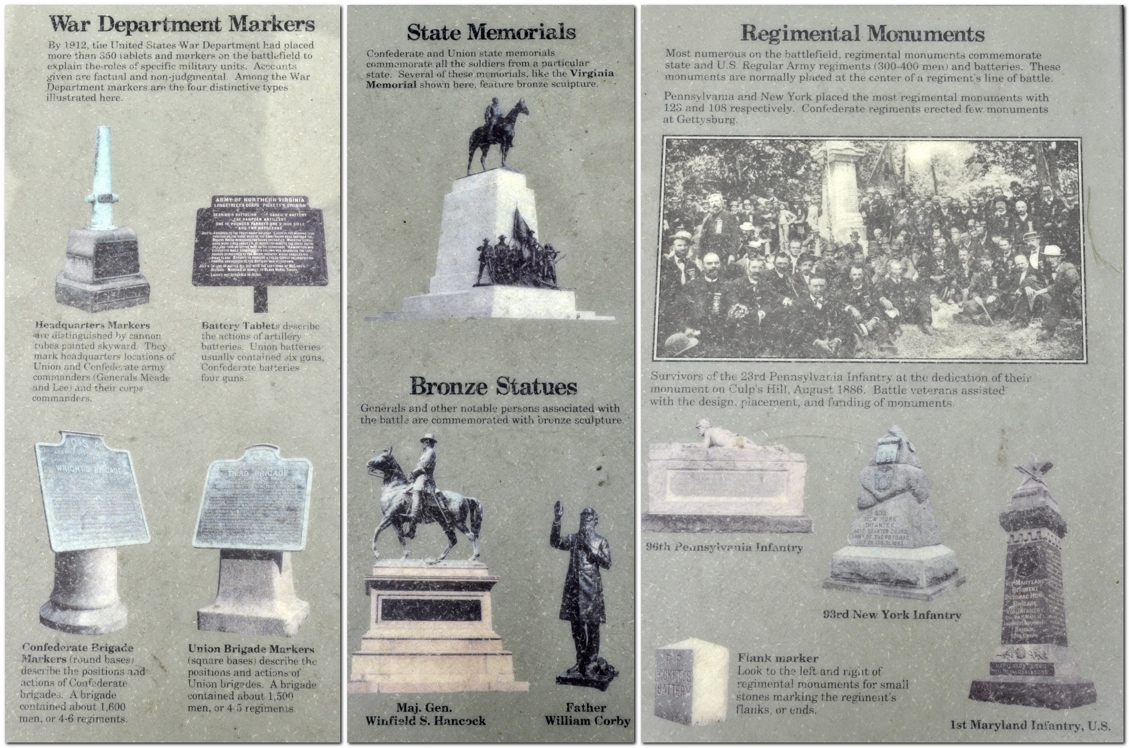
Gettysburg is on a far greater scale, and monuments (some small, some very large indeed) to the dead and wounded of many regiments are scattered but numerous right across the battlefield.
Our tour of the battlefield took about four hours. Rather than follow the recommended chronological route, taking in the locations of the battle as they unfolded, we headed first to Culps Hill where there is an observation tower that gives an excellent view over the entire battlefield. Another tower, on the west side affords views over sites where the Confederates were dug in, near the Virginia Monument (a huge statue of Lee on horseback) and near where the disastrous Pickett’s Charge by Confederates on the Union center was repulsed on 3 July, and Lee was forced to withdraw.
View west from the top of Little Round Top
Pennsylvania Monument, the largest on the battlefield, recording the names of every soldier who served at Gettysburg, PA
Minnesota Monument
Soldiers’ National Monument, where Lincoln delivered his Gettysburg Address
View east from East Cemetery Hill
View east from the Virginia Monument
View from Culps Hill observation tower
96th Pennsylvania Infantry
Statue of Union Brevet Maj. General George Sears Greene who defended Culps Hill
North Carolina Monument
Virginia Monument (General Robert E Lee on horseback)
View northwest from Little Round Top
It was a bright sunny day on our visit, a quiet morning that was so different from what was experienced 156 years ago. It was very moving as well. In this video you can experience something of what we did during our tour of the battlefield.
Our final stop was the Soldier’s National Monument where, on 19 November 1863, Abraham Lincoln delivered his Gettysburg Address, just 272 words long (POTUS 45 could learn something from Lincoln’s brief but telling oratory).
Lincoln had arrived in Gettysburg by train from Washington the previous day (exactly 85 years before I was born), and stayed overnight in David Wills’ house in the town square, just a block from the station.
The Confederates surrender
Two days later, we were at Appomattox Court House, which lies a couple miles east of Appomattox Station (town). Yes, there is a county court house there, but it was a small settlement that had grown up before Appomattox itself.
There are more than 30 buildings on the site, some original and some reconstructed (the NPS clearly indicates which). But the fact that some buildings are reconstructed does not detract in any way from the importance and significance of the site.
The court house was originally built in 1846 but burnt down in 1892; it was reconstructed in 1964 and is now the Visitor Center which houses an excellent museum on two floors.
The most significant building however, is the McLean House, a fine residence over three floors with outhouses for slaves, where the deeds of surrender were signed by Lee on 9 April 1865.
This house is also a reconstruction. After the surrender ceremony was over, and Lee had returned to his army to announce the terms of the surrender, Union officers relieved the McLeans of many pieces of furniture, including the two tables at which Lee and Grant sat. Today, these original tables are carefully preserved in museums, but the McLean House has faithful replicas on display. The poignancy of the surrender room, the front parlor, cannot be underestimated.
The tables at which Lee (L) and Grant (R) signed the deeds of surrender
Wilmer McLean was a well-to-do farmer who had brought his family west after the Battle of Manassas (Bull Run) in July 1861, the first of the Civil War. His farm was in the middle of the battlefield. Four years later, he was again surrounded by conflict—and peace! He is reported to have stated: The war began in my front yard and ended in my front parlor.
Grant offered Lee generous terms of surrender. Soldiers of the Army of North Virginia were paroled, allowed to return home, and even take their horses with them. Paroles were hastily printed in the Clover Hill Tavern just across the street from the court house.
However, the optimism of peace was shattered less than a week later when Lincoln was assassinated by secessionist sympathiser John Wilkes Booth in the Ford’s Theater in Washington.
During our trip we saw two very different aspects of the Civil War. But the war is not just battles and statistics. It’s also about people. The average age of soldiers on both sides was 20. They were mostly single and Protestant. Many came from farming stock. In one way, the Civil War is unique. It’s probably the first war that was fully documented photographically. Not only do we know the names of the soldiers who served. We also have recorded, for posterity, their likenesses in early photographs.
I’m currently reading this excellent book published by National Geographic (that I picked up, secondhand, in St Paul for under $10). And the human cost of war is certainly brought home in the various accounts and anecdotes retold therein.
After the war, there was (as might be expected) considerable analysis and introspection about the causes of the war, its conduct, outcome, and why soldiers served as they did. The NPS has put together three excellent pamphlets which I have combined in the image below (just click to open a larger image).
In two road trips, this year and two years ago when we crossed the Appalachians from Georgia through Tennessee, North Carolina, West Virginia and Virginia, I have traveled through much of the territory where the armies of the Union and Confederacy came to blows. It’s unforgiving terrain, and the thought that hundreds of thousands of soldiers, many poorly clothed, with ill-fitting shoes (or no shoes at all!) tramped backwards and forwards across these hills at the behest of their commanders fills me with awe and horror. This short video, taken from the top of Brasstown Bald (the highest point in Georgia) is typical of the terrain over which much of the conflict was fought.
~~~~~~~~~~~~~~~~~~~~~~~~~~~~~~~~~~~~~~~~
There are more photos of Gettysburg here, and Appomattox Court House here.
Steph and I are now relaxing with family in Minnesota.
We have just completed our 2019 road trip: almost 2050 miles across ten states (in yellow), and crossing state lines thirteen times (MA-RI-CT-NY-PA-NJ-DE-PA-MD-WV-VA-MD-DE-MD).
Our visit to the USA started at 03:00 on Tuesday 3 September, when we dragged ourselves out of bed to head to Birmingham Airport (BHX) to catch the 06:00 KLM flight to Amsterdam(AMS). We were surprised to find the airport heaving even at that early hour. While this flight departed on time, on arrival in Amsterdam we discovered, to our (slight) dismay that the onward Delta flight to Boston (BOS) was delayed at least two hours because of the late arrival of the incoming aircraft (from JFK, where severe weather has disrupted many flights the previous day).
But, to give Delta Airlines due credit, they turned the aircraft around quickly and we departed only slightly over two hours delayed. However, as you can imagine that had a knock-on for our arrival in BOS.
Immigration there was a bit of a nightmare. I had hoped to be on the road before 15:00 for the 93 mile drive south for our first night at Orleans on Cape Cod. Because of the various delays, it was closer to 18:00 before we headed out of the car rental center, immediately hitting Boston rush-hour traffic, and then crawling slowly south for at least 35 miles.
Budget car rental assigned us a Jeep Wrangler, perhaps a little bigger than I had contemplated, but it was comfortable and solid on the road.
I had planned to be at Orleans well before nightfall. It wasn’t to be, and I had to drive the last hour in the dark, not something I relish at the best of times. For the final 15-20 miles of the trip, US-6 narrowed to two-way (known locally as ‘Suicide Alley’). Nonetheless, we made it in one piece and enjoyed a good night’s rest.
We spent the first morning on Cape Cod, checking out various beaches, before traveling into Provincetown to view (from a distance) the Pilgrim Monument, erected between 1907 and 1910 to commemorate the landing of the Pilgrim Fathers in 1620. We also visited the site where Marconi built a transatlantic wireless communication station just after the turn of the 20th century.
Then we headed west to Newport, Rhode Island and the Beavertail Lighthouse at the southern tip of Conanicut Island at the entrance to Narragansett Bay, crossing the impressive Claiborne Pell Newport Bridge in the process.
Beavertail Lighthouse.
Then it was on to Plainfield, CT for our second night.
The next day we headed down to the Connecticut coast at Old Saybrook at the mouth of the Connecticut River, before turning west to have a picnic lunch and a walk on the beach at Silver Sands State Park in Milford, some 15 miles west of New Haven (home to Yale University).
Crossing the causeway at Old Saybrook on CT-154
The ‘dangerous’ sand bar out to Charles Island where is access is not permitted during the breeding season of various sea birds.
In the northwest of the state we visited Kent Falls State Park, before heading to Poughkeepsie (pronounced Puckipsee, home to Vassar College) on the banks of the Hudson River (and close to Hyde Park, the home of President Franklin D Roosevelt that we didn’t have time to visit).
Kent Falls State Park
In Poughkeepsie we found an excellent restaurant, The Tomato Cafe on Collegeview Ave just outside Vassar, and enjoyed probably the best meal of the trip.
From Poughkeepsie we had a long drive west into Pennsylvania before heading south and east to end up near Atlantic City on New Jersey’s coast. From the coast we headed west into Pennsylvania at Gettysburg.
Our day started early, crossing the Hudson River on US-44 at Poughkeepsie despite my satnav refusing to calculate a crossing there.
Crossing the Mid-Hudson Bridge at Poughkeepsie
Our first destination was the Delaware Water Gap National Recreation Area in Pennsylvania, and Dingmans Falls, just a mile west of US209, in particular. On the way there we came across the remains of the Delaware and Hudson Canal, whose construction started in 1823 to carry coal from the Pennsylvania coal fields.
The Visitor Center at Dingmans Falls was closed during our visit, but the boardwalk trail to the Falls themselves was an easy walk of just under a mile. However, the climb up to the top of the Falls was a little more challenging.
About 20 miles south of Dingmans Falls, the Delaware River cuts through the mountains and heads east. It forms the stateline between Pennsylvania and New Jersey. We stopped for a bite to eat at the Kittatinny Point rest area on the New Jersey side.
Looking west (from central northern New Jersey) towards the Delaware Gap.
By this time we were becoming a little concerned about reports of exactly where, on the Atlantic Coast, Hurricane Dorian would make landfall. High winds had been predicted for Atlantic City, and some rain, but as the storm was moving quite slowly, we had no idea if it would affect us or not.
We had already seen forecasts of severe weather in northern New Jersey (just south of New York) and we weren’t disappointed! I misread my satnav and exited from the highway one exit too soon, and found myself heading over the Raritan River at Perth Amboy on the wrong bridge. Fortunately my satnav quickly sorted me out, sending me back north over another bridge on Convery Boulevard, and entering the Garden State Parkway where I had originally intended. We only lost about 10 minutes, but driving among six or more lanes of fast-moving traffic in a downpour and with all the road spray was not an experience I would wish to repeat.
When we arrived at our hotel in Absecon (a few miles outside Atlantic City) it was certainly windy, the clouds were lowering, but there was no immediate threat of the hurricane hitting or any flooding, although our hotel (a rather inferior Travelodge) faced the marshes fronting the ocean.
The next morning dawned bright and sunny however, and hardly a breath of wind. Dorian had passed us by and headed out east into the Atlantic. What a difference a day makes!
The Atlantic City skyline from the northwest, sans hurricane.
So we drove into the center of the city, and walked up and down Atlantic City’s famous boardwalk for a couple of hours.
Longwood Gardens near Kennett Square in Pennsylvania (west of Philadelphia and northwest from Wilmington, DE) was not on our original itinerary. However, through a Facebook chat with a former colleague, accountant Lisa Panes, from IRRI in the Philippines, she mentioned that a visit to Longwood would be worthwhile. I’d never heard of the gardens before, but then discovered they are considered among the best in the USA. And not only that, just a few miles east of the original route I’d planned.
We spent four glorious hours wandering around the gardens. I’ll be writing about the gardens (and other locations we visited) in a separate blog post.
Tired and rather hot, we set off on the last leg to Gettysburg, passing through the heart of Amish country, at Intercourse, PA.
Sunday morning dawned bright and sunny. After breakfast we set off to the Gettysburg battlefield visitor center, received battlefield guide maps, and decided which routes to take. Over the whole site, seemingly every few yards, there are monuments to different regiments, both Federal and Confederate, and the many skirmishes that took place there over a period of three days in July 1863. Very poignant.
We also went into town to view Gettysburg station where President Lincoln arrived on 18 November 1863, just over four months after the battle.
At the end of the visit we strolled around the Gettysburg National Cemetery, and saw the spot where, on 19 November 1863, Lincoln delivered his Gettysburg Address. Have 272 words ever been more powerful?
After lunch we headed northwest from Gettysburg to Horseshoe Curve near Altoona, PA, a feat of railway engineering that was completed in 1854, would you believe.
From there, it was an 80 mile drive south to Frostburg in the mountains of northwest Maryland, a most beautiful landscape that I hadn’t expected. Our hotel there, a Quality Inn, was the best of the trip, about 1½ miles south of the town center, where we also had a lovely meal in an Italian restaurant, Giuseppe’s.
The next two days took us from Frostburg south through the Monongahela National Forest of West Virginia, before turning east into Virginia to spend nights in Appomattox (where General Robert E Lee surrendered the Army of Northern Virginia to Union General Ulysses S Grant at Appomattox Court House on 9 April 1865), and Colonial Williamsburg.
Seneca Rocks, in Pennsylvania, in the heart of the Monongahela National Forest, almost 74 miles south of Frostburg.
A typical West Virginia landscape in the Monongahela National Forest.
The McLean home at Appomattox Court House where General Lee surrendered to General Grant.
Colonial Williamsburg was not quite what I expected. It’s like a living museum, with quite a number of original buildings but many that have been reconstructed.
Our last day, Wednesday, was spent traveling north up the Delmarva Peninsula, stopping off for an hour at Lewes beach, before the last (and heavy traffic) push into Baltimore, for our final night close to Baltimore International Airport (BWI) from where we flew next day to Minneapolis-St Paul (MSP). This last day also included crossing the impressive Chesapeake Bay Bridge and Tunnels, almost 18 miles in length.
On the east Virginia shore, there’s an observation rest area where some of the bridges and causeway can be seen in the distance.
It was over 90F on the beach at Lewes.
So, for another year, our USA road trip is over. We averaged just over 240 miles per day (discounting the first day trip south to Orleans), and only on two days did we travel more than 300 miles (unlike in 2018, for instance, when most days were over 300 miles, and often closer to or more than 400 miles). So, in that sense, this year’s trip was easier, even though I felt the trip took more out of me than I had expected. Must be an age thing.
Overall, I was pleased with the Jeep. We spent only $203 on gasoline and achieved an impressive (considering the size of the vehicle) 26 mpg; $804 on hotels (or about £645 at current—and disappointing, Brexit -induced—exchange rates), and maybe $350 or so on meals.
Where to in 2020? Maybe the Rocky Mountain states, or do we bite the bullet and tour the southern states from Georgia through Alabama, Mississippi, Louisiana, Arkansas, Oklahoma, and Texas? Decisions, decisions!
Our journey through the Appalachian Mountains (the main focus of our 2017 road trip in the USA) took almost four days traveling through Georgia, North Carolina, Tennessee, Virginia, West Virginia, and Kentucky.
The Appalachians comprise a large system of mountains and valleys, covering a vast area of the eastern USA, and extending into Canada. We explored just the southern end.
Day 4 began in Greenwood, SC where we had stopped the night after traveling north from Savannah, GA the previous day. Leaving our hotel not long after 8 am, we headed west crossing quite soon back into Georgia and working our way northwest through the Chattahoochee National Forest towards Blairsville, GA.
The winding 35 mile climb on GA60 into the Chattahoochee (map) began at Stonepile Gap. With towering trees either side of the road there were few places to stop or see out over the landscape. One of these however was Chestatee Overlook, where we had a first real view of the rolling—and heavily forested—Appalachians.
We expected to arrive in Blairsville after 5 pm, but we were there by 3:30. Rather than heading straight to our hotel, we decided to make a 50 mile circuit to the north and east of Blairsville, and quite by chance came across the entrance to Brasstown Bald, the highest mountain in Georgia, at 4784 feet.
There is a steep drive up to the car park, and a shuttle bus takes you up the final (and very steep) final mile to the observation platform. We arrived around 4:30, just in time to catch the final shuttle of the day, but allowing only about 15 minutes at the summit before the last shuttle would depart for the car park. Given the steepness of the descent (14%), and concerns that my right leg might suffer, we opted for the return shuttle. The visit was somewhat marred by several bikers (who were old enough to know better) using the climb to the car park (a couple of miles at least on a winding road) to ‘race’ their very noisy chopper motorbikes. Quite unnecessary really.
However, it was a glorious afternoon, and the 360° panorama afforded views into North Carolina and Tennessee to the north, and probably Virginia to the east. Just imagine what it must look like in September and October ablaze in all its Fall colours.
The view from Brasstown Bald, GA
The following day, Sunday, our destination was Johnson City, TN taking in the Cherohala Skyway (map), a 50 mile scenic route stating at Tellico Plains, TN and ending at Robbinsville, NC.
The day started fine and sunny, and we weren’t disappointed in the Cherohala. Then we headed to the Great Smoky Mountains National Park, crossing south to north (map) towards Gatlinburg, TN on US441. Unfortunately, by the time we reached the park (one of the busiest in the whole of the country), the weather had deteriorated and it was raining heavily. The Smoky Mountains really were smoky. On the off-chance that we would be above the clouds, we took the seven mile diversion to Clingmans Dome on the North Carolina-Tennessee border, the highest point in the Smokies, at 6643 feet.
There was not a lot to see, to say the least. But dropping down towards Gatlinburg, the clouds did lift and we saw something of the Smokies after all.
Not long after we headed out, we ran into one of the most intense storms I’ve ever experienced. It was raining so hard I could hardly see in front of the car. We did wonder whether our visit to Cumberland Gap would be a wash out. But the closer we got, the weather started to improve, and the sun was even shining as we arrived at the national park. From the Pinnacle Overlook it was hit and miss, now you see it, now you don’t as the clouds closed in, then cleared. But we did have some wonderful views, nevertheless.
The Cumberland Gap has been a major route through the Appalachians for Native Americans and the Europeans who settled there, and wanted to head west.
Overlooking the Cumberland Gap
Cumberland Gap was a strategic route for both Union and Confederate armies during the American Civil War, and exchanged sides from time to time. There are still earthworks high up on the Pinnacle.
The following morning we set off early from Charleston, west into Kentucky. It was going to be a long day, and a rather complex route on minor roads through the Daniel Boone National Forest. This was gently rolling country, but nevertheless magnificent in terms of the trees lining the highways.
Towards the end of the afternoon, we hit the main highways again, heading further west to Cave City, KY for the night, and the next highlight of the trip: Mammoth Cave National Park.
Yes. That’s right. Eleven states in just ten days.
2764 miles to be precise. Ninety-four gallons of gasoline consumed. Almost 30 mpg at just USD209. That’s not bad considering we rented a Jeep Patriot SUV (with a Connecticut licence plate!).
I’d opted for a car rental through Rentalcars.com and chose Alamo as the best deal. Just USD357 for the actual rental, USD250 for the one way drop-off fee, and USD98 for roadside assistance cover and various taxes.
I had planned our route meticulously, taking in various sites and landscape features I thought would be interesting, and avoiding as much as possible any of the interstate highways. I bought Rand McNally road maps for all states except Virginia and Minnesota (we already had a DeLorme Atlas & Gazetteer for MN). I checked precise US and State Routes using Google maps since the scale of the Rand McNally didn’t always show the road name. I even used Google Streetview to check the various intersections, and before we traveled I already had an image in my mind of the entire route.
I prepared daily detailed route plans on cards, which Steph used to navigate us across country from Atlanta to Minnesota, with each map marked at decision points corresponding to the route card details (you can just make out a series of circles on the map below).
Fortunately, US roads are very well signposted and road signs (e.g. US61 or GA23, for example) are posted every few miles. It was hard to go wrong, but we did on three occasions; nothing major, however. My first mistake was leaving the car rental center at Atlanta Hartsfield-Jackson International Airport. I turned on to I-85N instead of I-85S, but was able to turn around within a mile. On two other occasions we made a turn too early, but realised almost immediately. Not bad really for such a long road trip. Nor did we encounter any road works that held us up, or any road accidents. We almost never saw a police car.
These four map links show the actual route we took over the ten days:
We stayed in ‘chain’ hotels like Best Western, Comfort Inn, Quality Inn and the like, about USD100 or so a night. In Savannah we stayed at The Planters Inn on Reynolds Square, close to the river and other historic attractions, and this was our most expensive at around USD230 including taxes and valet parking. Breakfast (if you can call it that) was provided in each hotel. For lunch, eaten by the roadside or at a scenic viewpoint, we picked up a freshly-made sandwich and with some fruit from the hotel, we had enough to keep us going until a substantial dinner in the evening. Surprisingly, we ate Mexican on three nights and had very good meals. There was even beer! Twice we ate at the nearby Cracker Barrel Old Country Store – reasonable food but no beer. Walking into our second Cracker Barrel in Troy, IL it was déjà vu; the layout of the restaurant and the store was identical to the one we patronised in Johnson City, TN.
Anyway, here is a summary of our epic road trip.
31 May, Atlanta, GA – Macon, GA, 82 miles
Our flight (DL73) from Amsterdam landed on time just after 14:15, and despite arriving at an E pier and having to walk the considerable distance over to the new F International Terminal for immigration and customs, then taking a 15 minute shuttle to the new car rentals center beyond the airport perimeter, we were on the road not long after 16:00. We were headed to Macon on I-75, some 82 miles southeast of Atlanta towards Savannah to spend our first night, and recover—to the extent possible—from our long day of travel from Birmingham (BHX), arriving to our hotel (Best Western on Riverside Drive) just around 18:00
Just arrived at Best Western in Macon
We had the room on the right of the balcony, overlooking Reynolds Square
1 June, Macon – Savannah, GA, 167 miles
Since we had only a relatively short journey to reach Savannah, and because I wanted us to get a good rest before setting off once again, we didn’t leave Macon until after 09:00. Our hotel in Savannah (Planter’s Inn on Reynolds Square) had contacted me that morning by SMS asking what time we expected to arrive and hoping to have a room ready then. Not only was our room ready at just after 11:00, but we’d been upgraded to a balcony room. Once we had settled in, we set off on a leisurely stroll around the historic riverside where the old cotton warehouses have been converted to restaurants and other retail outlets, as well as apartments.
Savannah oozes history (and Spanish moss) – a direct line of historical events from the early 18th century, when it was founded, through Colonial times, and the turmoil of the Revolutionary and Civil Wars.
Savannah, GA
2 June, Savannah – Greenwood, SC, 196 miles We spent the morning in Savannah absorbing the Colonial, Revolutionary and Civil Wars history of this beautiful city. The weather didn’t look promising, with thunderstorms forecast, so we left the hotel by 07:30 and wandered through the various squares, parks and colonial streets for three hours, with just a small shower to bother us. After freshening up at the hotel and checking out, we were on the road again by 11:30, headed for Greenwood in the northwest of South Carolina.
The US17 route out of Savannah crosses the Savannah River over the fine-looking Talmadge Memorial Bridge, completed in 1991, 185 feet above the water.
We passed through a heavy rainstorm for the first 20 miles or so, but the weather brightened, and we stopped for a bite to eat beside the road in glorious sunshine. The road north was almost completely straight passing through small towns with names like Denmark, Sweden and Norway. There wasn’t much evidence of much agriculture, just some maize on this coastal plain with rather sandy soils. Communities seemed quite impoverished (according to the 2010 census it is the 7th poorest state). Nevertheless, the Southern Baptist (and some Presbyterian) churches and chapels stood in stark contrast. I’ve never seen so many places of worship so close together. There must be a lot of wicked souls need saving in South Carolina (and surrounding states) to require so many churches, often within just a few hundred yards of each other (or closer).
We were in Greenwood by 17:00, found our hotel, the Hampton Inn, and enjoyed steak and seafood meals at the Red Lobster outlet beside the hotel.
3 June, Greenwood – Blairsville, GA, 195 miles
Distance-wise this was never going to be one of the longest days, but I had planned our route climbing into the Appalachians through the Chatterhoochee National Forest on US60, a winding road among the trees.
We departed from Greenwood around 08:00 and made our first stop at the SC-GA state line to look over the Savannah River at Calhoun Falls. We had another stop at Cleveland, GA to tour the historic courthouse museum, and arrived in Blairsville by about 15:00.
Not wanting to go straight to our hotel, the Comfort Inn, so early in the day, we opted for a 55 mile round trip taking in some of the hills and forest to the north and east of Blairsville, arriving to Brasstown Bald, the highest point in Georgia at 4500 feet, around 16:30 just in time to take the last shuttle bus to the summit, and down again. I decided not to walk the 1 mile descent from the summit to the car park because the average gradient was more than 14%, and Steph and I were concerned that I might hurt my right leg, which is still giving me some grief 18 months after I broke it.
4 June, Blairsville – Johnson City, TN 282 miles
This was our opportunity of really traveling through the Appalachians. I’d chosen to travel east along the Cherohala Skyway in North Carolina. We had expected some poor weather this day, so set off as early as we could get away in order to enjoy the early morning brightness. The Cherohala offers some spectacular views along the way, and we were not disappointed at all.
Looking south from the Cherohala Skyway over North Carolina
But the further east we went, the more cloudy it became, and by the time we reached US441 to cross the Great Smoky Mountains National Park, it was raining quite hard and we didn’t really see very much at all. We took the side route of about seven miles to Clingman’s Dome, the highest point over 6600 feet. Couldn’t see a thing! But lower down on the north side, the weather improved and we did see something of the Smoky Mountains.
We then dropped down to Gatlinburg in Tennessee. If you’ve ever harbored the desire to visit Gatlinburg – don’t. What a tourist disaster! A narrow highway through the center of the town, tackiest tourist souvenir stores lining both sides, and even though this was early in the tourist season, there were throngs of people about. I’m glad we were only passing through. Then it was on to our hotel on the outskirts of Johnson City.
5 June, Johnson City – Charleston, WV, 380 miles
The focus early in the day was the Cumberland Gap, northwest of Johnson City by about 80 miles or so. Not long after leaving Johnson City, along US11, we passed through one of the heaviest rain storms I’ve ever experienced. I could hardly see in front of the car. But by the time we reached Cumberland Gap, the clouds had lifted somewhat, and the sun appeared.
The ‘Cumberland Gap’ is familiar to me from my skiffle days, as sung by Lonnie Donegan.
We went up to the Pinnacle Overlook, hoping to see the views over Tennessee, Virginia, and Kentucky – even as far as North Carolina on a good day. It was only a case of ‘now you see it, now you don’t’ as the clouds came rolling in, then dispersed. As a major pass through the Appalachians, the Cumberland Gap was strategically important for both the Union and Confederacy during the Civil War of the 1860s, and changed sides every so often. There is still evidence of military occupation high on the Overlook.
Looking north into Kentucky and the town of Middlesboro. The highway has just emerged from the tunnel through the Gap.
Then later in the day, heading east towards Charleston, the capital of West Virginia, we traveled along The Trail of the Lonesome Pine in Virginia. Until I was planning this trip, I wasn’t even aware that the Trail was a real entity, not after I’d heard Laurel and Hardy singing about it.
6 June, Charleston – Cave City, KY, 371 miles
Our destination this day was Cave City in central Kentucky where we planned to visit the Mammoth Cave National Park the following day. Heading west out of Charleston on I-64, we turned south at Morehead in Kentucky (about 110 miles west) to head south through the Daniel Boone National Forest.
We traveled some 125 miles along scenic highways and byways. Then we turned west on the Cumberland Parkway west of Somerset, KY for the rest of the day’s trip to make up some time and so as not to arrive to our hotel too late. However, Kentucky is divided into two time zones, so we gained an hour (from Eastern to Central Time) about 80 miles east of Cave City.
7 June, Cave City – Troy, IL, 367 miles
The Mammoth Cave National Park opened at 08:00, and we were at the Visitor Center not long afterwards. I had booked a tour of the Frozen Niagara cave some months back, at 09:20. This was a guided tour, the first of the day, and to a cave that was easily accessible. I didn’t want to contend with scrambling over rocks with my leg. In any case we planned to stay at the Park only until late morning as we still had the whole day’s trip of over 350 miles to make.
We enjoyed the cave, along with a group of fewer than 30 others. The caves are kept closed and it’s generally not possible to visit them alone. What amazed us is that the cave system, at over 440 mapped miles is the largest system in the world. The Park gets very busy during school holidays, and we were fortunate to have visited when we did.
Our next port of call was Fort Defiance at the confluence of the Ohio and Mississippi Rivers, and the southernmost point of Illinois. Most impressive.
That’s the Ohio River behind us and the bridge between Kentucky and Illinois . . .
At Fort Defiance, at the southernmost tip of Illinois, at the confluence of the Mississippi and Ohio Rivers
Then we followed the Mississippi north towards St Louis and our hotel in Troy just northeast of the city, catching a glimpse of the famous Gateway Arch as we skirted the city center on the Illinois side of the river.
8 June, Troy – Iowa City, IA, 332 miles
Our plan was to follow the Mississippi north through Missouri into Iowa. Heading west around the north of St Louis we crossed both the Mississippi and Missouri Rivers close to their confluence. Heading north on MO79, we stopped at Clarksville to stretch our legs, and look at the dam and lock, where a very large combination of barges was being ferried northwards slowly against the current.
Further north we stopped also at Louisiana, MO to view the Champ Clark Bridge that connects MO and IL, from a vantage point high above the river.
Then it was on to our next, and last, overnight stop in Iowa City.
9 June, Iowa City – St Paul, MN, 333 miles
Our last day on the road, heading north on very straight roads, before crossing into southern Minnesota and crossing the Bluff Country eastwards to reach Winona on the Mississippi.
Just south of the Iowa-Minnesota state line we passed through Cresco, IA which proudly advertises itself as the birthplace of Dr Norman Borlaug, father of the Green Revolution in wheat and Nobel Peace Prize Laureate in 1973, who I had the honour of meeting when I worked at IRRI.
In Winona, we took a short diversion to a scenic overlook about 500 feet above the river valley and had a spectacular view north and south.
Then we set off with added determination to arrive to Hannah and Michael’s in the Highland Park area of St Paul by late afternoon, and the end of our enjoyable 2017 road trip adventure.
Here are the individual blog posts about the various places we visited: