Well, we booked our flights way back at the beginning of January. And here we are, five months later, in St Paul, Minnesota for a month-long vacation with our elder daughter Hannah and her family.
Our trip started very early last Thursday (9 May). I’d booked a local taxi for 03:30 to take us to Newcastle International Airport (NCL) for the flight to Amsterdam (AMS), so had the alarm set for 02:30. Just ten minutes before the scheduled pick-up time, I received a message on a phone app with the name of the driver, make and registration of the car, and when he would arrive. Imminently!
The roads were quiet at that time of the morning, as expected, and the 11 mile drive to the airport took less than 20 minutes.
All went smoothly at the KLM check-in; there was no-one in the queue ahead of us. Unlike last year when it was mayhem at NCL.
We quickly cleared security but then had to wait until 05:30 for the gate to open.
Once on board, the captain announced there would be a delay for about 1 hour due to fog at Schipol. Groans all round! But then, just five minutes later, he announced the good news that the weather had improved in AMS, and our flight had been given clearance to depart.
KLM operated a Boeing 737-800 (registration PH-BGC) on this sector.
It was bright and sunny, warm even, when we landed in AMS, around 08:20, but there was a very long taxi (around 15 minutes) to Gate D44.
Our connecting Delta flight (DL161) to MSP left from Gate E3 at 10:15. Schipol is a huge airport, and even with walkways it can take many minutes to walk from one gate to another. But as we’d arrived on time, we ‘enjoyed’ a leisurely stroll to our gate. Unlike last year when our arrival into AMS was delayed by more than 1 hour and we had to rush, arriving at the departure gate just as the flight was boarding. And as I’m still having some mobility issues, I was relieved we had the extra minutes this year.
Delta operated an Airbus A330-300 (registration N821NW) on this route. As with previous years we booked Delta Comfort+ seats. We enjoy the slightly bigger space and seat recline (and dedicated overhead bin space). And in the 2-4-2 seat configuration, window and aisle seats are a good choice for us. On the return journey last year, from Detroit (DTW) to AMS, I used airmiles to upgrade to Premium Economy. Not worth it!
The flight was almost completely full, yet despite that boarding proceeded smoothly and we actually departed about 10 minutes ahead of schedule.
This was one of the smoothest flights I’ve had over the North Atlantic, and although I never can sleep well on any flight, I must have snatched some, helped by a couple of these with my lunch, and another with a snack later on.
On arrival at MSP (Gate G2), at 11:40 (about 40 minutes ahead of schedule), there was quite a long walk from the plane to Immigration. With just a couple of passengers ahead of us in the queue, we sailed through, and both our bags arrived within 10 minutes. Hannah and Michael were waiting for us, and since they live just 4 miles (and around 9 minutes) from MSP, we were home by about 12:30 and soon enjoying a refreshing cup of tea.
In 2023 we visited the US for the first time since 2019 and made just a short road trip overnight to meet up with old friends Norma and Roger Rowe in La Crosse, Wisconsin. It was in September 2019 that we made our last long road trip, and I ‘vowed’ it would be our last. Until we agreed to make another trip this year. Who knows what’s in store in 2025?
Anyway, we’re flying out to Las Vegas (LAS) next Tuesday to begin a road trip of around 1800 miles across Utah and Colorado, visiting several national parks along the way: Kolob Canyon, Zion, Bryce, Arches, and Canyonlands in Utah, and Mesa Verde and Florissant Fossil Beds National Monument in Colorado. I’ve chosen some exciting (challenging, even) routes through the Rockies, taking in the ‘Million Dollar Highway’, weather permitting. And stopping off at the Hoover Dam in Nevada on the first day.
This is our planned route that will be subject to changes depending on road conditions at the time. But we do have all our overnight stops booked, so that much remains fixed.
Then, a week later, we’ll fly back to MSP from Denver (DEN).
Yesterday, we visited the Minnesota Valley National Wildlife Refuge (just 6 miles from Hannah’s house) to purchase an America the Beautiful National Parks and Federal Recreation Lands annual pass. At US$80 (=£64.29) this is great value, saving probably half of what we would pay for all the individual visits on our trip, and permits entrance to all the national parks and facilities of several other federal agencies.
We also enjoyed a short walk around one of the trails near the Visitor Center, and within just a few minutes of arrival saw an incredible array of bird species. We will be returning there and to several of the other trail sites along the Minnesota River.
So look out for more posts in the coming weeks because I’ll be writing about each day’s adventures, posting lots of photographs and dashcam footage as we wend our way through the various canyons and over the mountain passes.
Fifty years ago today, Steph and I were married at the town hall (municipalidad) in the Miraflores district of Lima, where we had an apartment on Avenida José Larco. Steph had turned 24 just five days earlier; it would be my 25th in the middle of November.
Municipalidad de Miraflores, Lima
It was a brief ceremony, lasting 15 minutes at most, and a quiet affair. Just Steph and me, and our two witnesses, John and Marian Vessey. And the mayor (or other official) of course.
John, a plant pathologist working on bacterial diseases of potato, was a colleague of ours at the International Potato Center (CIP) in Lima, who had joined the center a few months before I arrived in Lima in January 1973.
Enjoying pre-lunch drinks with Marian and John at ‘La Granja Azul‘ restaurant at Santa Clara – Ate, on the outskirts of Lima.
Steph arrived in Birmingham in September 1971, just after I had finished the one-year course. I was expecting imminently to head off to Peru where I had been offered a position at CIP to help curate the large collection of native potato varieties in the CIP genebank. So, had I flown off to South America then, our paths would have hardly crossed.
But fate stepped in I guess.
My departure to Peru was delayed until January 1973. So I registered for a PhD with renowned potato expert Professor Jack Hawkes (right, head of the Department of Botany and architect of the MSc course), and began my research in Birmingham while CIP’s Director General, Richard Sawyer, negotiated a financial package from the British government to support the center’s research for development agenda, and my work there in particular.
It must have been early summer 1972 that Steph and I first got together. Having completed the MSc written exams in May, Steph began a research project on reproductive strategies in three legume species, directed by Dr Trevor Williams (who had supervised my project a year earlier on lentils). And she completed the course in September.
By then, she had successfully applied for a scientific officer position at the Scottish Plant Breeding Station in Edinburgh (SPBS, now part—after several interim phases—of the James Hutton Institute in Dundee), as Assistant Curator of the Commonwealth Potato Collection. But that position wasn’t due to start until November.
Our VW Variant in Peru, around May 1973 – before receiving a Peruvian registration plate.
In early November I took delivery of a left-hand-drive Volkswagen for shipment to Peru. On a rather dismal Birmingham morning, we loaded up the VW with Steph’s belongings and headed north to Edinburgh. She returned to Birmingham in mid-December for her graduation.
Then, just after Christmas 1972, we met up in a London for a couple of days before I was due to fly out to Lima.
At that time we could not make any firm commitments although we knew that—given the opportunity—we wanted to be together.
Again fate stepped in. On 4 January 1973, Jack Hawkes and I flew to Lima. Jack had been asked to organize a planning conference to guide CIP’s program to collect and conserve native Andean potato varieties and their wild relatives.
Potato varieties from the Andes of Peru.
While I stayed in a small hotel (the Pensión Beech, in the San Isidro district) until I could find an apartment to rent, Jack stayed with Richard Sawyer and his wife Norma. And it was over dinner one evening that Jack mentioned to Richard that I had a ‘significant other’ in the UK, also working on potato genetic resources, and was there a possibility of finding a position at CIP for her. Richard mulled the idea over, and quickly reached a decision: he offered Steph a position in the Breeding and Genetics Department to work with the germplasm collection.
With that, Steph resigned from the SPBS and made plans to move to Lima in July, with us planning to get married later on in the year.
In the CIP germplasm screenhouses in La Molina. Bottom: with Peruvian potato expert Ing. Carlos Ochoa.
A couple of weeks after I arrived in Peru, I found an apartment in Miraflores at 156 Los Pinos (how that whole area has changed in the intervening 50 years), and that’s where Steph joined me.
In our Los Pinos apartment, Miraflores in July 1973.
A few weeks later we found a larger apartment, nearby at 730 Avda. Larco, apartment 1003. Very interesting during earthquakes!
Around mid-August 1973 we began the paperwork (all those tramites!) to marry in Peru. Not as simple as you might think, but on reflection perhaps not as difficult as we anticipated.
While we were allowed to post marriage banns in the British Embassy, we had to announce our intention to marry in the official Peruvian government gazette, El Peruano, and one of the principal daily broadsheets (El Comercio if memory serves me right), and have the police visit us at our apartment to verify our address. I think we also had to have blood tests as well. This all took time, but everything was eventually in place for us to set the wedding date: 13 October.
Some friends wanted to give us a big wedding, but Steph said she just wanted an intimate, quiet day. So that’s what we organized.
In the week leading up to our wedding, we had to present all the notarised documents at the municipality. After the ceremony, we signed the registry, hand-written in enormous volumes (or tomos). There was a bank of clerical staff, all with their Parker fountain pens, inscribing the details of each wedding in their respective tomo. A week later we collected our Constancia de Matrimonio (with some errors) which detailed in which tomo (No. 83, page 706) our marriage had been recorded, as well as photocopies (now sadly faded) of the actual page.
My work, collecting potatoes, took me all over the Andes; not so much for Steph who only made visits every other week or so to CIP’s highland experiment station (at over 3000 masl) in Huancayo east of Lima, and a six hour drive away.
However, Steph and I explored Peru together as much as we could, taking our VW on several long trips, to the north and central Andes, and south to Lake Titicaca. We also delayed our honeymoon until December 1973, flying to Cusco for a few days, and spending one night at Machu Picchu.
At Machu Picchu, December 1973.
In May 1975, we returned to the UK for seven months for me to complete my PhD, returning to Lima just before New Year.
With Jack Hakes and Trevor Williams at my PhD graduation on 12 December 1975 at the University of Birmingham.
Christmas Day 1976 in Turrialba.
Then, in April 1976, we moved to Costa Rica where I worked on potato diseases and production, based in Turrialba, some 70 km east of the capital city, San José. Under the terms of our visas, Steph was not permitted to work in Costa Rica. I became regional representative for CIP’s Region II (Mexico, Central America, and the Caribbean) in August 1997 when my colleague, Oscar Hidalgo (who was based in Toluca, Mexico) headed to North Carolina to begin his PhD studies.
Our elder daughter Hannah Louise was born in San José in April 1978. Later that year, we took our first home leave in the UK and both sets of grandparents were delighted to meet their first granddaughter.
24 April 1978 in the Clinica Santa Rita, San José, Costa Rica.
On home leave in the UK in September 1978.
With Steph’s parents Myrtle and Arthur (top) in Southend-on-Sea, and mine, Lilian and Fred, in Leek.
We spent five happy years in Costa Rica before moving back to Lima at the end of November 1980, and began making plans to move to the Philippines by Easter 1981.
However, in early 1981, a lectureship was created at the University of Birmingham, in the Department of Plant Biology (formerly Botany, where Steph and I had studied), for which I successfully applied. We left CIP at the end of March and had set up home in Bromsgrove (about 13 miles south of Birmingham in north Worcestershire) by the beginning of July.
4 Davenport Drive
A decade after we were married, we were already a family of four. In May 1982 Philippa Alice was born in Bromsgrove.
30 May 1982 in Bromsgrove hospital.
During the 1980s we enjoyed many family holidays, including this one in 1983 on the canals close to home.
Many other family holidays followed, in South Wales, in Norfolk, on the North York Moors, and in 1989, in the Canary Islands.
In Tenerife, Canary Islands in July 1989. Steph is carrying the binoculars that I bought around 1964 and which I still possess.
Hannah (left) and Philippa (right) thrived at local Finstall First School, shown here on their first day of school in 1983 and 1987, respectively.
My work at Birmingham kept me very busy (perhaps too busy), but I particularly enjoyed working with my graduate students (many of them from overseas), and my undergraduate tutees.
All in all, it looked like Birmingham would be a job for life. That was not to be, however. By the end of the 1980s, academic life had sadly lost much of its allure, thanks in no small part to the policies and actions of the Thatcher government. We moved on.
By 1993, we had already been in the Philippines for almost two years, where I had been hired (from July 1991) as head of the Genetic Resources Center (GRC) at the International Rice Research Institute (IRRI) in Los Baños, some 65 km south of Manila in the Philippines. I moved there ahead of Steph and the girls (then aged 13 and nine) who joined me just after Christmas 1991.
Meeting fellow newcomer and head of communications, Ted Hutchcroft and his wife at our joint IRRI welcoming party in early 1992.
In 1993 I learned to scuba dive, a year after Hannah, and it was one of the best things I’ve ever done. Philippa trained a couple of years later.
Getting ready to dive, at Arthur’s Place, Anilao, Philippines in January 2003.
Steph was quite content simply to snorkel or beachcomb, and we derived great pleasure from our weekends away (about eight or nine a year) at Anilao, 92 km south from Los Baños. In fact, our weekends in Anilao were one of our greatest enjoyments during the 19 years we spent in the Philippines.
Steph became an enthusiastic beader and has made several hundred pieces of jewelry since then. In Los Baños we had a live-in helper, Lilia, and so in the heat of Los Baños, Steph was spared the drudgery of housework or cooking, and could focus on the hobbies she enjoyed, including a daily swim in the IRRI pool, and looking after her garden and orchids.
Steph and Lilia on our last day in IRRI Staff Housing #15 on 30 April 2010.
Hannah and Philippa completed their school education at the International School Manila (ISM) in 1995 and 1999 respectively, both passing the International Baccalaureate Diploma with commendably high scores.
Graduation at ISM: Hannah and Philippa with their friends from around the world.
Traveling to Manila each day from Los Baños had not been an easy journey, due to continual roadworks and indescribable traffic. It was at least two hours each way. By the time Philippa finished school in 1999, the buses were leaving Los Baños at 04:30 in order to reach Manila by the start of classes at 07:15.
In October 1996, Hannah started her university degree in psychology and social anthropology at Swansea University in the UK. However, after two years, she transferred to Macalester College, a highly-rated liberal arts college in St Paul, Minnesota, graduating summa cum laude in psychology and anthropology in May 2000. She then registered for a PhD in industrial and organizational psychology at the University of Minnesota. Philippa began her BSc degree in psychology at the prestigious University of Durham, UK later that same year, in October.
Hannah’s graduation in May 2000 at Macalester College, with Philippa and Michael (Hannah’s boyfriend, now her husband).
Once Hannah and Philippa had left for university, IRRI paid for return visits each year, especially at Christmas.
Christmas 2001. Michael joined Hannah for the visit.
While my work took me outside the Philippines quite often, Steph and I did manage holidays together in Hong Kong/Macau and Australia. And, together with Philippa, we toured Angkor Wat in Cambodia in December 2000.
But Steph also accompanied me on work trips to Laos, Bali, and Japan. She also joined me and my staff when we visited the rice terraces in northern Luzon in March 2009.
Enjoying a cold beer as the sun goes down, near Sagada, northern Luzon, Philippines.
Overlooking the Batad rice terraces in northern Luzon in March 2009.
However, we always used our annual home leave allowance to return to the UK, stay in our home in Bromsgrove (which we had purposely left unoccupied), and meet up with family and friends.
Philippa was awarded a 2:1 degree in July 2003, and the graduation ceremony took place inside Durham Cathedral. She then headed off to Vancouver for a year, before returning to the UK and looking for a job, eventually settling in Newcastle upon Tyne where she has lived ever since.
Outside Durham Cathedral where Phil received her BSc degree from the university’s Chancellor, the late Sir Peter Ustinov.
Hannah married Michael in May 2006, and finished her PhD. We flew to Minnesota from the Philippines.
15 May 2006, at the Marjorie McNeely Conservatory in Como Park, St Paul.
PhD graduation at the University of Minnesota.
Philippa registered for a PhD in biological psychology at Northumbria University in Newcastle upon Tyne where she was already working.
Professionally, the period between 2001 and my retirement in 2010 was the most satisfying. I had changed positions at IRRI in May, moving from GRC to join the institute’s senior management team as Director for Program Planning and Communications (DPPC). I worked with a great team, and we really made an impact to increase donor support for IRRI’s research program. However, by 2008/9 when my contract was up for renewal, Steph and I had already agreed not to continue with IRRI, but take early retirement and return to the UK.
But as our retirement date approached in April 2010, I was honored by the institute’s Board of Trustees with a farewell party (despedida) coinciding with the 50th anniversary of the very first Board meeting in April 1960.
14 April 2010 – IRRI’s 50th celebration dinner and our despedida.
Friday 30 April was my last day in the office.
With my DPPC friends. L-R: Eric, Corinta, Zeny, me, Vhel, and Yeyet.
We flew back to the UK two days later, arriving on Monday 3 May and taking delivery of our new car, a Peugeot 308, the following day.
Philippa and Andi flew off to New York in October 2010 and were married in Central Park. She graduated with her PhD in December.
By 2013 we had been married for four decades, and were well-settled into retirement, enjoying all the opportunities good weather gave us to really explore Worcestershire and neighboring counties, especially as National Trust and English Heritage members. And touring Scotland in 2015, Northern Ireland in 2017, Cornwall in 2018, East Sussex and Kent in 2019, and Hampshire and West Sussex in 2022.
We were, by then, the proud grandparents of three beautiful boys and a girl.
Callum Andrew (August 2010) – St Paul, Minnesota
Elvis Dexter (September 2011) – Newcastle upon Tyne
Zoë Isobel (May 2012) – St Paul, Minnesota
Felix Sylvester (September 2013) – Newcastle upon Tyne
And how could we ever forget a very special day in February 2012, when Steph, Philippa and my former colleague from IRRI, Corinta joined me at Buckingham Palace for an investiture.
Receiving my OBE from King Charles III (then HRH The Prince of Wales) on 14 February 2012.
With Steph and Philippa outside the gates of Buckingham Palace.
With Corinta and Steph in the courtyard of Buckingham Palace after the investiture.
Since 2010, we have traveled to the USA each year except during the pandemic years (2020-2022), and only returning there this past May and June. We’ve made some pretty impressive road trips around the USA, taking in the east and west coasts, and all points in between with the exception of the Deep South. Just click here to find a list of those road trips.
In July 2016, a few months after I broke my leg, Hannah and family came over to the UK, and we got together with Phil and Andi and the boys for the first time, sharing a house in the New Forest.
Our first group photo as a family, near Beaulieu Road station in the New Forest, 7 July 2016. L-R: Zoë, Michael, me (still using a walking stick), Steph, Callum, Hannah, Elvis, Andi, Felix, and Philippa.
And they came over again in July 2022, to our new home in the northeast of England where we had moved from Bromsgrove in October 2020 at the height of the Covid-19 pandemic.
In our garden in Backworth, North Tyneside, August 2022.
L-R: Felix, Elvis, Zoë, and Callum, at Dunstanburgh Castle, Northumberland in August 2022.
So it’s 2023, and fifty years have passed since we married.
During our visit to the USA this past May and June, we met up with Roger Rowe and his wife Norma, along the Mississippi River at La Crosse in Wisconsin.
Roger joined CIP in 1973 as head of the Breeding and Genetics Department and was our first boss. Roger also co-supervised my PhD. So it was great meeting up with them again 50 years on.
We’ve been in the northeast just over three years now, and haven’t regretted for a moment making the move north. It’s a wonderful part of the country, and in fact has given us a new lease of life.
At Steel Rigg looking east towards the Whin Sill, Crag Lough, and Hadrian’s Wall, Northumberland, February 2022.
Steph has taken great pleasure in developing her new garden here. It’s a work in progress, and quite a different challenge from her garden in Worcestershire, discovering what she can grow and what won’t survive this far north or in the very heavy (and often waterlogged) soil.
22 August 2023
I’ve had much enjoyment writing this blog since 2012, combining my interests of writing and photography. It has certainly given me a focus in retirement. I never thought I’d still be writing as many stories, over 700 now, and approaching 780,000 words. Since returning to the UK, I’ve also tried to take a daily walk of 2-4 miles. However, that’s not been possible these past six months. A back and leg problem has curtailed my daily walk, but I’m hopeful that it will eventually resolve itself and I’ll be able to get out and about locally, especially along the famous North Tyneside waggonways.
After 50 years together, we have much to be thankful for. We’ve enjoyed the countries where we have lived and worked, or visited on vacation. Our daughters and their families are thriving. Hannah is a Senior Director of Talent Management and Strategy for one of the USA’s largest food companies, and Philippa is an Associate Professor of Biological Psychology at Northumbria University.
Sisters!
With Hannah and Michael, Callum and Zoë (and doggies Bo and Ollie, and cat Hobbes) in St Paul, MN on 18 June 2023.
With Philippa and Andi, Elvis and Felix (and doggies Rex and Noodle) on 2 September 2023.
And here we are, at South Stack cliffs, in the prime of life (taken in mid-September) when we enjoyed a short break in North Wales.
Steph with Philippa and family on her birthday on 8 October.
13 October 2023 – still going strong!
While drafting this reminiscence, I came across this article by Hannah Snyder on the Northwest Public Broadcasting website, and it inspired the title I used.
I have been very fortunate. There’s no denying. Since I made my first trip outside the UK, to the west coast of Ireland for a botany field course in July 1968, followed a year later, in September 1969 to participate in a folk festival in Czechoslovakia, I’ve had so many opportunities to travel around the globe—to more than 60 countries (sometimes on vacation, but mostly on business associated with my work in international agricultural research).
Morris dancing at the folk festival in Strakonice, Czechoslovakia in 1969. That’s me on the extreme right.
I’ve lived and worked in three countries (besides the UK of course): Peru (1973-76); Costa Rica (1976-1980); and the Philippines (1991-2010). I’ve visited several countries multiple times, and others just the once. Whenever I was traveling on business, I would also try to fit in some tourism over a weekend if possible. I have so many memories over those 55 years. Here are some that spring to mind.
The Americas I guess I should begin this section with Peru. In 1971 I was thrilled to be offered a job in Peru, at the newly-founded International Potato Center (CIP), although I didn’t actually travel there until January 1973.
13 October 1973
So many memories. Steph and I were married in Lima in October 1973.
Looking at a farmer’s field of potatoes in the Mantaro Valley near Huancayo.
Solanum lignicaule, 2n=2x=24, from southern Peru
In Pisac market
The street of the thirteen-sided stone.
Cuzco cathedral.
School time.
North of Ayacucho, but before the Mantaro gorge.
Arequipa’s cathedral with El Misti in the background.
On the river near Puerto Bermudez
Near Cuzco in southern Peru, 1974
Machu Picchu
Sacsayhuaman at Cuzco
It’s almost impossible to choose any one aspect that stands out. The diversity of landscapes, with desert on the coast, the high Andes, and the jungle on the eastern side. The long history of agriculture in difficult environments, and the archaeology of civilizations that go way back before the invasion by the Spanish in the 16th century.
Then we moved to Costa Rica in April 1976, living in Turrialba, about 70 km east of the capita, San José. Once again I was working on potatoes and with farmers.
We enjoyed our five years in that beautiful country, and our elder daughter Hannah was born there in April 1978.
A land of volcanoes (some very active), Costa Rica is a verdant country, and there are national parks everywhere. The bird and plant life is extraordinary, so I guess this is what stands out for me in particular.
Potato fields of var. Atzimba on the slopes of the Irazu volcano
Northern Costa Rica on the way to Monteverde.
Just after we’d taken delivery of our VW Brasilia
Typical ox carts in Costa Rica
Steph and Hannah at the Monteverde Biological Reserve
A respendent quetzal that we saw at Monteverde
Carrying Hannah on my back at Monteverde
Tamarindo Beach on the Guanacaste coast in northwest Costa Rica
CATIE in Turrialba
The Turrialba volcano from our garden at CATIE
Hannah growing up at CATIE
On a visit to the Poas volcano
My work took me to all the countries of Central America, as well as to Mexico where, until 1977, CIP’s regional headquarters was based just outside Mexico City at Toluca. And also out into the Caribbean islands, to Haiti and the Dominican Republic, to Jamaica, St Kitts, Antigua, Montserrat, Barbados, and Trinidad.
In Mexico, most of my visits were to Toluca. But on one visit there, I joined the participants of a potato training course to study potato production in Mexico State, Michoacán, Puebla, Jalisco, and Guanajuato. Later, in the 1980s I also visited Nuevo Leon in the north, and Morelos south of Mexico City.
But if I had to choose one highlight, it would be the pyramids at Teotihuacán, northeast of Mexico City that Steph and visited in 1975 when we visited some friends at CIMMYT (a sister center to CIP) on our way back to the UK.
Guatemala is a fascinating and beautiful country, and I was a regular visitor. A land of lakes and volcanoes, it has a high indigenous population, who wear the most colorful fabrics.
In 1977, Steph and I flew into the Mayan city of Tikal, deep in the jungle, for an overnight stay.
On another trip I spent a few days in Belize, first in Belize City on the coast, then in Belmopan, the smallest capital city in the Americas.
The overriding memory I have of Honduras was the white-knuckle landings in Tegucigalpa. How they managed to land jets there is beyond me. What pilot skill!
I visited El Salvador and Nicaragua just once each, and then only overnight. They had virtually no potato sector.
Flying in and out of Panama City was quite a regular occurrence. It was a transit for Costa Rica from South America. The main potato area was in the west of the country near the frontier with Costa Rica (map), north of the city of David at Volcán and Boquete. A region of deep volcanic soils, it was very good potato-growing country, and one I traveled to by road from my base in Turrialba on a couple of occasions.
Potato fields in Boquete, northern Panama
It was only after I moved to the Philippines in 1991 that my work took me back to Costa Rica for the first time in about 15 years, and one other country, Venezuela, which I’d not visited before although landing at Caracas airport on several occasions. This airport is located on the Caribbean coast north of the city, and is connected by a 27 km motorway that crosses the mountains, a spectacular drive over what I assume is a northern extension of the Andes.
In the 1990s I spent a week in Caracas attending a potato network meeting, but seeing very little of the city, just the metro from hotel to meeting venue and back!
Another international agricultural research center in Cali, Colombia is CIAT (map), supported in the same way as CIP and CIMMYT (and the rice institute, IRRI, in the Philippines, that I joined in 1991). Located in the Cauca Valley, CIAT is surrounded by huge plantations of sugar cane, but the rice-growing area is nearby as well. The last time I was there (and in Peru and Mexico) was in July 2016 conducting a review of the CIAT genebank.
I was in Chile just the once, for a week in Santiago in July 1979. I’d flown down from Costa Rica to join two colleagues from Lima to carry out a short review of the Chilean potato program. Two things come to mind: wine and ABBA. Wine, because we were taken to dinner at Enoteca, a fine restaurant overlooking the city on Camino Real, where all the wines produced in Chile were on display, and we were invited to sample many of them. On one evening, while out enjoying some souvenir shopping, I heard (for the first time) the refrains of Chiquitita by ABBA emitting from one of the shops. My visit to Santiago will always be associated with ABBA.
What can I say about Brazil? It’s huge. My first visit there was in 1979 when I attended a potato conference at Poços de Caldas in Minas Gerais (map), followed by a couple of nights in Rio de Janeiro. On another occasion I attended a conference in Foz do Iguaçu (in Paraná state) close to the border with Argentina and Paraguay, and site of the impressive Iguazu Falls.
I’ve been to Brasilia twice, and once upon a time, that nearly became home for Steph and me when CIP’s Director General deliberated whether to post me to Brazil or the Philippines. In the event we returned to the UK in 1981 when I joined the faculty of the University of Birmingham.
I guess the most impressive thing I’ve experienced in Brazil is the statue of Christ at Corcovado, high above Rio de Janeiro, with the most spectacular views over the city. My dad was there in the 1930s.
I’ve been to Canada twice, the first time in 1979 (with Steph and 15 month-old Hannah) when I attended a potato conference in Vancouver, then we drove across the Rockies to meet up with my late elder brother Ed and his wife Linda in Edmonton, AB.
In the early 2000s, I made a short visit to Ottawa to meet with representatives of Canadian overseas development assistance agencies, and managed to spend a day getting to know the city, before heading back to the USA.
Parliament Hill from the banks of the Ottawa River
Over the decades I’ve traveled to the USA many times, and have now visited all states and DC except Hawaii, Alaska (although one flight touched down in Anchorage), Idaho, Nevada (I changed flights in Las Vegas), Oklahoma, Kansas, North Dakota, Louisiana, Mississippi, and Alabama. It’s such a vast country, but since 2011, Steph and I have managed several mega road trips and seen so many wonderful sights. It’s hard to pick any one. I have written about these trips and you can find a link here; just scroll down to the USA section).
However, I’ve often said since we made the visit there in 2011, that if I ever got the opportunity to return, it would be to Canyon de Chelly in northeast Arizona. It’s a special place.
Canyon de Chelly, AZ
Spider Rock in the Canyon de Chelly
There’s not a lot of potatoes grown throughout the Caribbean, with only the Dominican Republic having any significant potato program, in the central highlands close to the border with Haiti. The Dominican Republic became one of the founder members of a regional potato program, PRECODEPA, set up in 1978, so I guess I must have traveled there five or six times.
I was just the once in Haiti, in the late 1970s attending a conference for about a week. We stayed in a nice hotel overlooking Port-au-Prince, and ventured out into the city just the once. Even then the city was not a safe place to wander round, and following the disastrous 2010 earthquake followed by the cholera outbreak, the country has become even more ungovernable, and not somewhere I would want to visit again. It’s one of the poorest countries in the Western Hemisphere.
I also paid short visits to Jamaica, St Kitts, Montserrat (which had a small but thriving potato sector before the Soufrière Hills volcano erupted in 1995, covering half the island with ash), Barbados, and Trinidad. Before long-haul jets could make the flight direct from Europe to South America, Antigua was a refuelling stop, which I made a couple of times. And after being being bumped off a flight to Montserrat, I spent the night in Antigua at a luxury resort (the only hotel bed I could find on the island!) and enjoying a delicious lobster dinner for the same price as a steak.
My first trip to Asia, to Indonesia in fact, was in the early 1980s, when I attended a genetic resources meeting in Jakarta, but spending a weekend at the Bogor Botanical Garden beforehand. The oil palm tree on the right below is one of the original trees introduced into Asia and became the foundation of the oil palm industry.
Bogor botanical garden
Bogor botanical garden
One of the original oil palms in the garden
Over the 19 years I spent living in the Philippines, I returned to Indonesia several times, the most memorable being in September 2005 when the IRRI Board of Trustees held one of it bi-yearly meetings there. Steph was able to join me on that trip, and along with excursions into the Bali countryside, we also enjoyed a long weekend break at our hotel before returning to the Philippines.
Bali landscape, Indonesia
In the Philippines, we lived in Los Baños, some 60 km south of Manila, where IRRI had its research center.
On the IRRI experiment station, with Mt Makiling (a dormant volcano) in the background.
Although we didn’t travel much around the Philippines (and apart from one short trip to Cebu, we didn’t wander beyond the island of Luzon), we went to the beach most months, and in March 2009, Steph joined me and my DPPC staff when we took an office outing over five days to the rice terraces in the mountains north of Manila. Very impressive.
Looking south towards Banaue town center.
In 1993 I learnt to scuba dive, one of the best things I’ve ever done, opening up a totally new world for me. The Philippines has some of the best diving in the world, especially at Anilao south of Manila.
Diving at Anilao, Philippines
But one of the best things about the Philippines? The Filipinos! Always smiling. Such friendly people. And I had great Filipino colleagues working with and for me in both the roles I took on at IRRI.
The ‘IRRI All Stars’ who helped during the IRRI Day in October 2002.
Colleagues from the Genetic Resources Center.
In 1995, I launched a major rice biodiversity project (funded by the Swiss government), and one of my staff, Dr Seepana Appa Rao was recruited to help the national rice program in Laos to collect native varieties of rice. Over five years, I visited Laos at least twice a year, taking part several times in a baci ceremony to welcome me to the country, and other visitors as well. Steph joined me on one trip, and here we are during one such ceremony at the house of my colleague, the late Dr John Schiller.
On that particular trip, we took a weekend off, flying to Luang Prabang and enjoying a river trip on the Mekong.
Mekong River, nr. Luang Prabang, Laos
IRRI had a country program in Cambodia, and I visited a couple of times to discuss rice germplasm conservation, and stayed in Phnom Penh. But after Christmas 2000, Steph and I were joined by our younger daughter Philippa (who had just begun her undergraduate studies at the University of Durham in the UK) for a mini-break in Cambodia (and Singapore).
We flew from Phnom Penh to Siem Reap, and spent three nights there visiting the amazing Angkor Wat temple complex, and a boat trip on the Tonle Sap, before flying back to the capital for one night, and back to Singapore.
We celebrated the New Year in Singapore, taking in the beautiful botanic gardens. Work has taken me to Singapore on several occasions, and Changi airport has to be one of the world’s aviation destinations. How it must have changed since I was last there.
Work took me to Seoul in South Korea on several occasions, and Japan. Steph joined me on one trip to Japan in September 2009 when the IRRI Board of Trustees met in Tsukuba north of Tokyo. We stayed on for a long weekend sightseeing in Tokyo, although she got to see more than I did earlier in the week, when a series of excursions for IRRI and Trustee wives were organised from Tsukuba.
Narita airport was also a hub for Northwest Airlines (now Delta) for flights from Manila to the USA, so I would fly through there at least a couple of times a year, also Osaka.
I’ve been to Beijing in China a couple of times, taking in the Great Wall during my first visit in 1995.
With my colleague, Bao-Rong Lu (middle) on the Great Wall, north of Beijing
On that trip we also took in Hangzhou and Guangzhou. I was in Beijing again around 2005 for a meeting, and in 2004, Steph and I flew to Hong Kong over Christmas and New Year. We also crossed to Macau on that trip.
The view from Victoria Peak, Hong Kong
Ruins of St Paul’s, Macau
Again, Hong Kong was one of those hub airports that I passed through many times, first at the old Kai Tak airport alongside Kowloon harbor (an interesting approach), and later at the new airport reclaimed from the sea.
I’ve only been to India a handful of times, always to meetings, and only then to Delhi and Hyderabad, so I can’t say that I’ve ever seen much of the country. There’s no doubt it’s a fascinating country, but I’m not sure it’s really on my bucket list – except if I could travel on one of those luxury trains, perhaps.
The same goes for Bangladesh, with just a couple of visits to Dhaka so I can’t say that I’ve ever known the country.
I was in Sri Lanka just the once, spending most of my time in Kandy. The hotel where I stayed was outside the city, on a hill, with breath-taking views over the surrounding hills. And I remember waking up early one still morning, and listening to the bird calls echoing all around. Magic!
I been to the north and south of Vietnam. On my first trip, I traveled to Can Tho in the Mekong Delta, and on the return journey to the airport in Ho Chi Minh City, I had to cross the river in a small boat (the bridge was down) and flag down a tuk-tuk for the last 20 km or so. I caught my flight!
Then I was in Hanoi several times in connection with the rice biodiversity project, but in 2010 I was the chair of the science committee for the 3rd International Rice Congress held in that city.
Myanmar has been closed off to visitors for many years, but I was able to visit just the once in the late 1990s, to the rice genebank at Yezin, about 250 miles north of the old capital Yangon. The train ride was interminable, and the sleeper on the return journey left a lot to be desired in terms of comfort and cleanliness. Nevertheless it was an interesting visit, but compared to the cuisine of other countries in the region (especially Thailand and Indonesia) the food was not inspiring: served quite cold and swilling in oil.
I’ve been in Bangkok many times, as it where I would change flights for Vientiane in Laos, having to spend one night to catch the early morning flight on Thai or Lao Airlines. But I never got to know the country, just a couple of visits to Chiang Mai in the north (again for meetings but no tourism). The same goes for Malaysia, with meetings in Kuala Lumpur and Penang.
In 2014 IRRI once again asked me to chair the science committee for the 4th International Rice Congress that was held in Bangkok, so I made several visits there (and on to the Philippines) before the congress was held in November.
Australia
I’ve been in Australia four times. As a family, Steph, our elder daughter Hannah, Philippa and I flew from the Philippines just after Christmas 1998 to Sydney, spending just under a week there, enjoying a trip up into the Blue Mountains, and watching the awesome fireworks display over Sydney Harbour on New Year’s Eve.
I made a work trip there around 2001, taking in Canberra, the rice-growing area in the Riverina, Adelaide, and Melbourne.
In December 2003, Steph and I drove from Sydney to Melbourne over the course of a week, taking the train back to Sydney, where we enjoyed a harbour dinner cruise.
At the Sydney Harbour Bridge during our Christmas vacation in Australia in December 2003
We spent New Year’s Eve on the south coast near Melbourne.
Next stop: Antarctica
The last time I was there was November 2016, when my friend and former colleague, Professor Brian Ford-Lloyd flew from Birmingham to Melbourne for three days as part of a review of genebanks.
Enjoying a stiff one on the Emirates A380 flight from Melbourne to Dubai.
Africa
Africa now, where I have visited Morocco in the north, Ghana, Ivory Coast, and Nigeria in West Africa, Ethiopia and Kenya in East Africa, and Zambia, South Africa, Mozambique, and Madagascar in southern Africa. I wrote this general account in 2013.
There are several international agricultural research centers in Africa: ILRI (a livestock center) in Kenya and Ethiopia; World Agroforestry (ICRAF) in Kenya; IITA in Ibadan, Nigeria; and Africa Rice (WARDA) in Bouaké, Ivory Coast. I have attended meetings there on several occasions. In Ethiopia, the ILRI campus is located in Addis Ababa, and during my first visit there, in January 1993, I had the opportunity of traveling down into the Rift Valley. What I most remember about that trip, and the stay in Addis, was the incredible bird life. An ornithologist’s paradise. Likewise on the campus of IITA in Nigeria. IITA has a 1000 ha campus, and part of it has been left as pristine rainforest with its assemblage of species, some of them crop wild relatives.
Looking for wild yams on the IITA Forest Reserve.
I made my first visit to Nigeria and Ivory Coast after the genetic resources meeting in Addis Ababa in 1993. For security reasons, visitors to IITA who arrive in Lagos in the afternoon and evening spend the night there, before being escorted to Ibadan, around 2 hours by road to the northeast. I always enjoyed my visits to IITA. But Lagos airport was another thing. The situation there did improve, but throughout the 1990s, I always felt uneasy passing through, as officials (some in uniform, others in plain clothes) would often ask for a bribe.
I must have visited Ivory Coast a couple of times, the first time flying from Abidjan (the capital) to Bouaké on the national airline, a Boeing 727 that had once been the presidential aircraft! I made those visits before the disastrous civil wars of 2002-2004 and 2010-2011.
Africa Rice had to abandon its research center in Bouaké for many years, although the institute has now returned there. I planted a tree during my first visit. I wonder if it’s still there?
With Deputy Director General Perter Matlon at the tree planting.
On another occasion, I was in Ghana for a week, attending a planning meeting, and didn’t see much of Accra outside my hotel.
I’ve been in Kenya probably half a dozen times, straddled the Equator, and enjoyed the wildlife in the Nairobi National Park.
With my dear friend from CIMMYT, the late Sir Bent Skovmand (from Denmark), wheat pathologist and then head of the CIMMYT wheat genebank.
In October 2005, I was in Marrakech, Morocco to attend the annual meeting of the CGIAR, the consortium of donors and international centers. I got sick, and I had to work on a project proposal so spent much of my time in my hotel room, with just one excursion to the souk for some souvenir shopping.
Looking for silver beads for Steph.
In southern Africa, I spent several days in Lusaka, Zambia visiting the SADC genebank there. I’ve passed through Johannesburg several times, and on my transit there (on my way to Lusaka) was caught up in a car bomb incident on the day of the election that first brought Nelson Mandela to power in April 1994. On another occasion I spent a week in Durban (meetings once again) with a side trip to Pietermaritzburg, almost 90 km inland from Durban,
IRRI had a country program in Mozambique, and I was there a couple of times. The rice program joined our biodiversity project, and the CGIAR held its annual meeting there in 2009.
I was in Madagascar just the once, staying in the capital Antananarivo on the east coast, and traveling along dreadful roads north to the rice experiment station. Madagascar also participated in the rice biodiversity project.
At a training course on rice genetic resources in Madagascar in 1998.
Middle East
I had the opportunity of visiting Izmir in Turkey in April 1972, one of my first overseas trips from Birmingham, to attend a genetic resources conference. There was an excursion to Ephesus.
On another visit (also to Izmir) in the late 1970s, I spent a day in Istanbul before taking an evening flight to the UK, enjoying the Topkapi Palace and various mosques.
The Blue Mosque
I was fortunate to travel to Syria several times, to Aleppo, before the civil war pulled the country apart. Another agricultural research center, ICARDA, had its headquarters there and genebank. I even went for a job interview once. It’s a beautiful country, and I guess many of the beautiful almond orchards have probably been destroyed in the fighting. I also spent some time in Damascus, visiting the famous souk there.
In 1982, I took a party of graduate students from the University of Birmingham to Israel for a two week course on genetic resources of the Mediterranean. I wrote about that visit here.
And then there’s Dubai in the United Arab Emirates. I’ve spent a few nights there in between flights but never had enough time to explore the city. When Emirates Airlines began a service from Manila (MNL) to Dubai (DXB), and on to Birmingham (BHX), we flew that route each year on home leave, and Emirates also became my airline of choice for trips into Europe. In the 1990s it had either been with Lufthansa into Frankfurt (FRA) or KLM into Amsterdam (AMS).
Europe
Steph and I have been married almost 50 years but we’ve never taken a vacation on mainland Europe. But my work has taken me there quite often, and to three countries, Germany, Switzerland and especially Italy, several times a year between 1991 and 2010.
On that first trip to Czechoslovakia in 1969, we traveled by road, through the Netherlands, southern German, and into Czechoslovakia.
I was next in Germany in the late 1980s, when I visited agricultural research institute near Hannover (also taking in the scenic town of Celle), before crossing into East Germany. I spent several interesting days at the genebank in Gatersleben (now part of The Leibniz Institute of Plant Genetics and Crop Plant Research), before flying on to Warsaw in Poland.
There I gave a series of seminars on crop evolution and genetic conservation (focusing on potatoes) to staff of the agricultural research institute (IHAR). My hosts took me to the family home of Frédéric Chopin west of Warsaw. As we walked around the gardens, we could hear several of Chopin’s piano pieces broadcast over speakers there. His Mazurka in D Major has remained a firm favorite ever since (here interpreted by acclaimed pianist Vladimir Horowitz), and is always a reminder of that visit whenever I hear it.
I also took in Cracow in the south of the country, a most elegant city.
While I was DPPC at IRRI, my work with the institute’s donors took me many times into Europe, particularly to Germany (Bonn and Frankfurt), to Switzerland (at Bern), and to Rome in Italy.
I had a good friend, plant pathologist Dr Marlene Diekmann, who lived near Bonn, and who worked for one of the German aid agencies. Whenever I was in Bonn, we’d try and spend some time walking the wine terraces of the Ahr Valley south of Bonn.
The last time I was in Bonn was 2016 during the genebank review I mentioned earlier.
I love trains, and have often traveled that way from one European capital to another. In fact I have traveled from my former home of Bromsgrove in Worcestershire to Rome, with stops in Belgium, Germany, and Switzerland on the way.
One of the best trips I made was to view the Matterhorn in Switzerland near Zermatt. I had a free weekend before I had to travel on to Rome, so I took the opportunity of a day excursion from Bern.
My trips to France have taken in Paris, where I spent a very wet weekend once walking around the city. But it was worth it. And to Montpellier on the Mediterranean coast several times, the last being in 2016.
Brussels (in Belgium) has a beautiful central square, but I’ve never had much time to explore there.
For many years, Amsterdam was a hub airport for home leave flights back to the UK. In the Netherlands, I’ve spent time in the university town of Wageningen (east of Amsterdam), in the capital, The Hague, and in Amsterdam itself. A boat tour of the canals is well worth it.
My donor trips took me to Lisbon in Portugal and Madrid in Spain, which I wrote about in this blog post from 2019. Then in 2012, Steph and I visited my late eldest brother Martin and wife Pauline at their beautiful home in Tomar, north of Lisbon. What a glorious 10 days.
Central square in Tomar
I was in the Canary Islands (part of Spain) a couple of times, collecting various wild crop relatives. Steph, the girls, and me had a holiday there in 1989.
On the north coast of Tenerife
Looking over the Tenerife landscape.
However, the country I have visited most in Europe is Italy, and Rome in particular. I was once in the Po Valley southwest of Milan, looking at the rice research there. The Food and Agriculture Organization of the United Nations (FAO) has its headquarters in Rome, as does Bioversity International (formerly the International Plant Genetic Resources Institute, IPGRI). I guess over the 19 years I spent in the Philippines, I must have traveled to Rome at least once a year for one meeting or another, and up to five times in one year. It’s a magnificent place, although my elder daughter Hannah who has just spent a few days there commented on how dirty it was, and full of tourists. But I’ve always enjoyed my stays there, and have had ample opportunity to enjoy the history and archaeology, and the fantastic cuisine.
I’ve only been in Austria, Norway, and Denmark on one occasion each, and in the capitals Vienna, Oslo, and Copenhagen. In Vienna, I spent a week at the International Atomic Energy Agency (where they have a program in mutation breeding) consulting on germplasm databases. I visited donor agencies in Norway and Denmark, but had no time for any tourism in Oslo. It was a different situation in Copenhagen where I looked round the pretty city over a weekend.
I started this blog post in the Republic of Ireland, and Steph and I have returned there three times, two with Hannah and Philippa in the 1990s, and also in 2017 after we’d spent a little over a week touring Northern Ireland.
Northern Ireland was a revelation. Prosperous, and beautiful. We visited many National Trust properties over there, and I wrote about our 10 days there afterwards, with links in the post to many of the properties we visited.
Giant’s Causeway, Northern Ireland
In Great Britain (United Kingdom minus Northern Ireland), Steph and I have visited so many National Trust and English Heritage properties around the country. This link gives a complete list (and maps) of all those we have visited.
Since we returned to the UK in 2010, we have toured Scotland, spent time in the south and southeast of England, and in Cornwall.
South Harris beach, Outer Hebrides
Calanais Standing Stones, Isle of Lewis
Isle of Skye
Stormy weather at the Butt of Lewis
The Lizard, Cornwall
Cape Cornwall
Tintagel Castle, Cornwall
At the White Cliffs of Dover, Kent
Th whole family together for the first time, in the New Forest in 2016
South Harting from Hartin Down, West Sussex
Now that we are living in the northeast of England, we have spent time exploring Northumberland, including its incredible Roman heritage.
The Whin Sill along Hadrian’s Wall
As a small boy, I spent many holidays with my parents in different parts of Wales, and Steph and I will be returning there at the beginning of September to renew our acquaintance with North Wales after so many decades.
So, there we have it. Fifty-five years of travel. So many special experiences.
Recently, I was asked to choose one of the most beautiful places I have visited. Well beauty lies, as the saying goes, in the eyes of the beholder. What one person finds appealing leaves another cold.
However, to choose just one place, that really is a challenge. But I’m up for it!
I have visited more than 60 countries, and whenever possible, took a day or so from my busy schedules (mainly at weekends) for some sightseeing. So there are many candidates to choose from.
I lived abroad for almost 28 years, in Peru and Costa Rica between 1973 and 1981, and in the Philippines from 1991 to 2010. Our elder daughter lives in the USA (in Minnesota) and Steph and I have visited each year since 2010 and traveled extensively across that vast country. Until Covid put paid to our plans, that is.
In the Americas, I could choose Crater Lake in Oregon, the Grand Canyon and Monument Valley in Arizona, or the giant redwoods of northern California. Not to mention the many spectacular rivers we have crossed or the mountains like the Tetons and Appalachians we have traveled along.
Giant redwoods, CA
Cherohala Skyway, TN
Grand Canyon, Arizona
Crater Lake, OR
Mountains near Yellowstone National Park, Wyoming
Monument Valley, AZ
Ohio River, Ohio-Kentucky
Grand Teton, WY
In Central America, we visited the Aztec temples north of Mexico City, the ruins of Tikal in Guatemala, and the Monteverde Cloud Forest in Costa Rica. In Peru, there’s the awe-inspiring Machu Pichu, and well as the beauty of the Andes mountains.
Machu Pichu, Cuzco
Huascaran, Peru’s highest mountain, Ancash
Tikal, Guatemala
Teotihuacan, Mexico
At Monteverde Cloud Forest Reserve, April 1980
In Europe, I fulfilled a life-long ambition to see the Matterhorn, and almost anywhere you travel in Switzerland is chocolate box beauty.
Matterhorn, Switzerland
At Kleine Scheidegg, Switzerland
My travels in Africa have taken me to Ethiopia and Kenya in the east, and the magnificent Rift Valley, and to regularly to Nigeria and Ivory Coast in the west.
Water buffalo in the Nairobi National Park, Kenya
Traveling around Asia, I spent many happy times in Laos, and on one occasion Steph and I managed to snatch a weekend away in the ancient capital of Luang Prabang, and take a trip up the Mekong River. In Cambodia, we’ll never forget our visit to Angkor Wat, while the beauty of the Bali landscape and beaches is firmly embedded in my mind. In the Philippines, we visited the coast at Anilao as frequently as possible, about nine visits a year, where Steph would snorkel and I would scuba dive over some of the most diverse coral reefs in the world. And again, there’s the wonder of the rice terraces in the mountains.
Mekong River, nr. Luang Prabang, Laos
Diving at Anilao, Philippines
Bali landscape, Indonesia
Sunset at Anilao
Rice terraces at Banaue, Philippines
Angkor Wat, Cambodia
Bayon, at Angkor Wat, Cambodia
Heading further south, our travels have taken us on several occasions to Australia and one memorable road trip of 1000 miles from Sydney to Melbourne taking in the spectacular coastline.
Wilson’s Promontory, Victoria, Australia
And not to miss out on locations closer to home such as the Giant’s Causeway in Northern Ireland, or the landscapes and beaches along the Northumberland coast where we now live.
Giant’s Causeway, Northern Ireland
Druridge Bay, Northumberland
Coquetdale, Northumberland
But how can I distill all these experiences down to just a single choice? It’s very hard indeed. But in doing so, and I will reveal my choice shortly, I have also taken into consideration not only its intrinsic beauty, but the location, history, and emotions it stirred. And when I combine all these elements, I have chosen the one place (not yet mentioned) I would return to tomorrow, given half the chance.
And where is this particular jewel? Canyon de Chelly National Monument (pronounced Canyon de Shay), in northeast Arizona. Just zoom out on the map below to reveal its location.
It’s certainly not on the same scale as its ‘near’ neighbor the Grand Canyon. But there’s something about Canyon de Chelly that really caught my imagination. And Steph and I have the good fortune to visit there in May 2011.
So how did I come to learn about Canyon de Chelly? It’s not a name that rolls off the tongue.
Well, in early 2011 I came across a book in the public library in Bromsgrove (in Worcestershire where I used to live) about US army officer, Indian fighter, explorer and adventurer, Colonel Christopher Houston ‘Kit’ Carson (1809-1868). Kit Carson was a western ‘hero’ of my boyhood, a figure in popular western culture and myth.
In 1863, he led an expedition into Canyon de Chelly to vanquish the resident Navajo tribe, killing more than 20 persons, stealing 200 or more sheep, destroying their homes (known as hogans) and their precious peach orchards. Not something to be proud of or remembered for as a hero. Anyway, this biography of Carson had me intrigued, and as I began to plan our road trip to the American Southwest for May, I decided to see if it would be possible to include Canyon de Chelly in the itinerary. It fitted in just right.
Landing in Phoenix, we headed north through Sedona Valley to Flagstaff, and on to the Grand Canyon the next day via Sunset Crater Volcano National Monument and Wupatki National Monument. After a couple of nights at the Grand Canyon, we headed east to Chinle (the nearest town to Canyon de Chelly) via Monument Valley.
The Canyon de Chelly National Monument actually comprises three interconnected canyons: Chelly, del Muerto, and Monument. It was designated a national monument in 1931. It’s the ancestral home of the Navajo, but throughout there are the relics of Ancestral Pueblans or Anasazi built into the cliff faces.
Access to the floor of the canyon is limited, with just one trail—to the White House—open to the public (although currently closed due to safety and ‘law enforcement’ issues). Otherwise, visitors must take one of the guided tours to travel along the canyons.
However, there are rim drives on the north and south sides of the canyon, with several overlooks providing spectacular (awe-inspiring even) views. Steph and I set out early from our motel, before the day became too hot, to explore as much as possible along both rim drives.
The approach to Canyon de Chelly from Chinle is not particularly impressive. In the canyon bottom there are groves are cottonwoods springing up beside the creeks that run through.
But it’s not until you begin to climb further along the rim drives that the true nature of Canyon de Chelly reveals itself, with sheer sandstone cliffs rising from the canyon floor.
In places these cliffs are 700 feet or more high.
Among the impressive Ancient Pueblan ruins are Mummy Cave and Antelope House (seen from the north rim drive), and the White House from the south.
Mummy Cave
Antelope House
White House
There is also a cave, fairly close to the rim on the north side known as Massacre Cave where, in 1825, the Navajo were slaughtered by invading Spanish troops.
Massacre Cave
The drive along the south rim eventually brings you to the Spider Rock overlook. Spider Rock is a free-standing sandstone pillar, over 700 feet tall, named after Spider Woman, a prominent character in Navajo lore.
Spider Rock, with the Chuska Mountains on the Arizona-New Mexico border on the horizon.
There were few people visiting at the same time as us, and it felt as though we had the whole canyon to ourselves. While we didn’t descend to the canyon floor, the overlook points along both the north and south rim drives provide excellent visual access to the canyon from above.
Spider Rock overlook
Now I’d like to return, taking several days to really explore, understand better the Navajo relationship with Canyon de Chelly, how they came to occupy it, and how their agriculture has evolved over the centuries. In fact, I’d like to understand more about the evolution of human societies in the American southwest.
The grave of Col. ‘Kit’ Carson in Taos cemetery, New Mexico.
Canyon de Chelly has featured in at least 26 movies or TV specials, among the most notable being The Lone Ranger (2013) with Johnny Depp, Wild Wild West (1999) with Will Smith, Kenneth Branagh, and Kevin Kline, Mackenna’s Gold (1969) with Gregory Peck and Omar Sharif, How The West Was Won (1962) with a host of ‘Western’ stars, and The Big Country (1958) with Gregory Peck, Jean Simmons, and Charlton Heston.
Heading east from Arizona, we found ourselves in Taos in northern New Mexico where I visited the grave of Kit Carson.
If you ever find yourself on the border of Arizona and New Mexico, make a beeline for Canyon de Chelly. You won’t regret it.
Ernest who? Ernest Marples. Minister of Transport in the Harold Macmillan and Alec Douglas-Home Conservative governments between October 1959 and October 1964.
As Minister of Transport he introduced parking meters, the provisional driving licence, the MOT test, yellow parking lines, and traffic wardens. He also oversaw an expansion of the road network and the opening, in November 1959, of the first section (53½ miles) of the M1 motorway, between Luton and Crick (although it had been inaugurated a year earlier).
The M1 was not the country’s first motorway, however. That honor is given to an 8¼ mile section of the Preston by-pass, opened in November 1958, and which became part of the M6 motorway.
I remember the first time my father took us on the recently-opened first section of the M1. It must have been around 1960. What an experience on such wide carriageways, and very little traffic. That’s hardly the case today. More like Chris Rea’s The Road to Hell, released in 1989, supposedly about the London Orbital Motorway, the M25, although, to be fair, it could be about any of our motorways.
So much congestion, lines of juggernauts traveling nose-to-tail. I never relish having to take one of the motorways for my journeys, but they are a necessity. Many motorways were constructed with three lanes in each direction, but some like the M5 (opened in 1962 and connecting the West Midlands with the southwest of England) had only two for much of its length, but later widened to three.
From those humble beginnings more than 60 years ago, the motorway network in Great Britain (not including Northern Ireland) now extends over 2300 miles (out of a total of 247,500 total road miles). Another 29,500 miles are A roads, major routes connecting cities, but only about 18% are what we in the UK call dual carriageways (divided highways in the US).
Originally there was no speed limit on the motorways. In December 1965 a temporary speed limit of 70 mph was introduced and made permanent in 1967. That remains in force today on motorways and dual carriageways, with 60 mph the limit on other A and B roads. The limit in urban areas is generally 30 (maybe 20) mph.
But if you want to really explore the countryside, as Steph and I like to do, then you have to get off the main routes and take the B roads, as you can see in this video, which I made recently as we crossed Northumberland (in the northeast of England). In any case, for me it’s never about the trip itself but the many interesting places and sights along the way.
I passed my driving test (at the second attempt) in May 1966, six months after my 17th birthday, the earliest age when one can apply for a driving licence here in the UK. I got to drive my father’s car from time to time, but while away at university between 1967 and 1972 I didn’t have much opportunity to drive, until I had my own car (in October 1971), a rather battered Ford Anglia. In September 1972 I bought a new left-hand drive Volkswagen Variant to export to Peru, where I moved in January 1973.
Between 1973 and 1981 we lived in Peru and Costa Rica (in Central America), and from 1991 spent almost 19 years in the Philippines (from where we traveled to and down the east coast of Australia). We also made two road trips around Ireland in the 1990s while on home leave from the Philippines. Our road trip experiences were very different.
Since retiring in 2010, however, Steph and I have enjoyed several road trips around the UK. taking in Scotland in 2015, Northern Ireland in 2017, Cornwall in 2018, and Sussex and Kent in 2019.
And, since 2010, we have (until the Covid pandemic struck) visited the USA every year and made some epic road trips that are described briefly later on.
Touring Peru
A couple of months after I arrived in Peru, the ship carrying my Volkswagen finally docked at Callao, the port for Lima. It was just the right sort of vehicle for the rugged roads that Steph and I traveled exploring that fascinating country. Solid suspension (although I did add heavy-duty shock absorbers) and an air-cooled engine.
Almost five decades ago, there were few paved roads in Peru, the main one being the Panamerican Highway stretching the whole length of the country, just a single carriageway in each direction. And the Carretera Central from the coast to the central Andes at Huancayo, crossing the high pass at Ticlio on the way.
Most elsewhere, apart from in the towns and cities, the roads were unpaved. And through the Andes, these roads followed the contours of the valleys. Often you could see your destination in the valley below, but know there would be many kilometers to travel as the road snaked down the valley, as you can see in these photos.
Above Tarma on the road to San Ramon
Then there was the ever-present danger of landslides which might take hours if not days to clear, or precipitous drop-offs at the side of the road. I remember on one occasion driving along one road (in fog) in the north-central part of Peru, and afterwards checking the maps to discover that the drop was about 1000 m.
Three of the most interesting trips we made were to Arequipa and Puno on the shore of Lake Titicaca in the south of the country, to Cajamarca in the north, and to Ayacucho and the central Andes on another occasion.
In Costa Rica
Many of the roads in Costa Rica were paved when we lived there in the mid-70s, with some notorious exceptions. Turrialba, where we lived, lies 41 km due east from Cartago (San José lies a further 19 km beyond Cartago). From Turrialba to Cartago, there’s a climb of almost 800 m, passing through a cloud zone (zona de neblina) on a narrow and twisting road that was, back in the 1970s, unpaved for most part.
Further this was the main route from the Caribbean port of Limón on the east coast to San José, and was always busy with one juggernaut after another. Not to mention the tractors towing a dozen or more sugar cane carts along sections of the road, without any hazard lights whatsoever.
The Philippines
Mostly, the Philippines has good roads. It’s just the congestion and the lack of driver discipline that makes driving in that country stressful. Also, farmers drying their rice or maize harvest along one side of an already narrow road.
Drying maize along the highway in Nueva Ecija, north of Manila. The more numerous rice farmers do the same.
We lived in Los Baños, the Science City of the Philippines, location of the University of the Philippines-Los Baños, the Institute of Plant Breeding, a local office of PhilRice, as well as the headquarters of the International Rice Research Institute (IRRI) where I worked for almost 19 years.
Los Baños is sited along the shore of Laguna de Bay, and on the lower slopes of a dormant volcano, Mt Makiling. It’s almost 65 km south of Manila and, on a good day, a little under 90 minutes by road. Back in the day we used to joke that it took anywhere between 90 minutes and a lifetime to make the journey. Major road improvements took almost 15 years to complete and with traffic congestion (caused mainly by tricycles and jeepneys) the journey could take several hours. Here’s a short video of a trip to Tagaytay (a town that overlooks the Taal volcano), about 50 km west of Los Baños by the quickest route (map).
In 2009, my staff, Steph and I made a long-weekend trip to the world-famous rice terraces in the Ifugao-Mountain Province of northern Luzon. Staying in Banaue, we took a jeepney to the end of the trail leading to the Batad rice terraces.
From there we had to hike for well over an hour deep into the valley.
Steph and I would also spend about eight weekends a year on the coast at Anilao (map) where I scuba dived and she would snorkel.
When we first visited Arthur’s Place in March 1992, there was no passable road from Anilao to the resort, and we had to take a 30 minute outrigger or banca ride. By 2009, the road had been paved.
Touring the USA
I really enjoy driving in the USA, once I’d become familiar with a number of the driving norms and the various road signs. Our elder daughter lives in Minnesota so our trips have begun or ended there. Thank goodness for the interstate highways whose construction was begun under President Eisenhower in the 1950s. We prefer to follow the US or state highways mostly if we can, even county roads.
These are the trips we have taken:
2011 – the southwest states of Arizona and New Mexico, taking in the Grand Canyon, Monument Valley, Canyon de Chelly, among other wondrous sights.
2015 – since we had already traveled round Scotland earlier that year, we visited Chicago by train instead.
2016 – I’d broken my leg in January, so when we visited in September, we spent a few days seeking out the source of the mighty Mississippi in Minnesota.
And, along these travels, one thing that caught my attention. In the UK, road construction has involved the building of just a few major bridges, over river estuaries, the most recent being a second bridge crossing the Firth of Forth west of Edinburgh in Scotland.
Not so in the USA. East-west or north-south, immense bridges had to be constructed across the many rivers that criss-cross that vast country. Some of the most impressive have been along the Mississippi, Missouri, and Ohio Rivers.
Simon Kenton Memorial Bridge over the Ohio River at Aberdeen, OH connecting OH and KY on US62.
Champ Clark Bridge carrying US54 from IL to MO at Louisiana, MO.
Bridges over the Ohio and Mississippi Rivers at Fort Defiance State Park, connecting KY, IL and MO.
South Grand Island Bridge over the Niagara River, NY.
Over recent weeks, Steph and I have been enjoying the latest series of Digging for Britain on BBC2, hosted by Alice Roberts who is Professor of Public Engagement in Science at the University of Birmingham. In this ninth series (as in the earlier programs) she visited digs all over the UK where archaeologists were busy uncovering our distant (and not-so-distant) past, and the lives of the people who lived there.
In one program she visited a (secret) site in Rutland (England’s smallest county in the East Midlands) where, in a farmer’s field, the most remarkable Roman mosaic floor had been uncovered, depicting scenes from the Trojan War. This was only one of many treasures that were ‘discovered’ during the series.
The British landscape has been transformed by multiple waves of immigration and conquest over thousands of years. But scrape away the surface, as archaeologists are wont to do, and fascinating histories begin to emerge, from prehistoric times through to the arrival of the Romans in AD 43, and in the centuries afterwards.
Sites like Stonehenge or the Avebury Stone Circle remind us that humans were living in and modifying these landscapes thousands of years before the Romans arrived on these shores.
Avebury Stone Circle.
Northumberland in the northeast of England (where I now live) is particularly rich in Roman remains. Besides the iconic Hadrian’s Wall, forts like Housesteads or Chew Green, and towns like Corbridge and Vindolanda are a visible reminder that these islands were once under the military control of an empire the like of which the world had never seen before. Northumberland was the northwest frontier.
And after the Romans departed in the 5th century AD, northern tribes such as by Angles, Saxons, and Jutes from continental Europe made these islands their home.
However, I often view our landscape as essentially post-Norman (that is, after 1066) since the Normans (and their descendants) left so many statements of their hegemony: magnificent castles (such as Prudhoe, Warkworth, and Dunstanburgh that stand as proud ruins even today), manor houses, churches and abbeys, and royal hunting parks.
I guess our appetite for the archaeological past was whetted when we moved to Peru in 1973. Within two weeks of landing in Lima in January I had already visited Machu Picchu while attending a meeting in Cuzco. Then, after Steph arrived in Lima in July, we spent many weekends exploring the coast and heading off into the numerous valleys that lead inland from Lima. In December, I took her to Machu Picchu (for a delayed honeymoon!)
Over the three years we spent in Peru, five in Central America, and more recently in the southwestern United States, we have visited a number of iconic pre-Columbian archaeological sites, and others less well known.
It’s not just the remains that various cultures have left behind, however. It’s also understanding their connection with the environment, the types of agriculture practiced for example, and the crops that were domesticated and brought into cultivation (a particular interest of mine).
So permit me to take you on a brief archaeological travelogue through the Americas.
Hiram Bingham III
As I’ve already mentioned Machu Picchu, perhaps I should start there. I guess it’s not only the location of this Incan refuge, but something of the mystery that surrounds it until it was ‘discovered’ by Hiram Bingham III in 1911 (although there are earlier claimants).
But tales of a lost city in Peru certainly caught the public imagination, and soon Machu Picchu was a notable tourist destination. In 1973, the rail journey between Cuzco and Machu Picchu was slow and left early in the morning. Nowadays the line has been upgraded and beside the river (way below the ruins) a small town has sprung up to accommodate the multitude of tourists who descend on Machu Picchu daily from all over the world.
I made just a day visit there in January 1973. However, Steph and I were lucky to reserve a room at the turista hotel that once stood just outside the ruins. So, once most tourists had returned to Cuzco late in the afternoon, we (and a handful of other hotel guests) had the ruins to ourselves. Next morning we breakfasted early to watch the sun rise, and enjoy the peace and quiet of this iconic site until, late morning, it was thronging once again with a trainload of tourists.
In many ways it’s not surprising that Machu Picchu remained ‘undiscovered’ for so long, five centuries after the last Inca took refuge there. Other ruins, further out into the jungle, have been uncovered in recent years, like Choquequirao, a two day hike from Cuzco.
What is remarkable about Cuzco, the Inca capital before the Spaniards arrived in the 16th century, is the juxtaposition of Incan and colonial architecture, in many places the latter built over the former. The beautiful Incan stonework is epitomized, for example, in the 12-sided stone in Calle Jatun Rumiyoc, east of the Plaza de Armas (the city’s main square).
Or the foundations of the Qorikancha temple (right) on which the colonizing Spaniards built the Santo Domingo convent five centuries ago.
Outside and overlooking Cuzco from the north is the impressive Inca fortress Sacsayhuamán (below). It’s not only its size, but especially the precision with which the stones have been placed together, some stones (like that shown below) weighing tens of tons at the very least.
Just 32 km to the northeast of Cuzco, and standing at the head of the Sacred Valley of the Incas is the market town of Pisac. Even in 1973 it was a major tourist attraction, even though it had changed little from almost 40 years previously when my PhD supervisor Professor Jack Hawkes had visited as a young man of 24. Check out these photos I took in 1973, and compare them with scenes in the film that Jack made in 1939 (after minute 25:25).
Above the town, 15th century terraces or andenes stretch up the hillside, where there are also temple remains; due to limited time we didn’t have an opportunity of exploring those nor travel further down the valley to Ollantaytambo where there are also impressive Inca remains.
Andenes above the town of Pisac.
But what is particularly remarkable about the Incas is the relative short period (perhaps a little over 300 years until the Spanish conquest in the mid-16th century) in which they held domain over many of the other cultures that had gone before them. Not only in the mountains, but on the coast as well, as I shall describe a little later.
But talking of terraces, I was fortunate to visit the small town of Cuyo Cuyo in Puno in the far south of Peru, in February 1974 while undertaking some fieldwork for my PhD research. Agricultural terraces built centuries ago are still being farmed communally today (at least when I visited almost 50 years ago).
Potato terraces at Cuyo Cuyo, Puno in southern Peru.
While some terraces had fallen into disrepair, the majority were still being carefully tended, and planted with a rotation of potatoes-oca (a minor Andean tuber crop)-barley or beans-fallow over about an eight year period. Impressive as they are, terraces like those at Cuyo Cuyo can be seen in many valleys all over Peru, but perhaps not so actively farmed as there.
Puno is one of the highest cities in the world, at just over 3800 m (12,556 ft), alongside Lake Titicaca, the highest navigable lake.
On a peninsula overlooking a lake about 33 km northwest of Puno stands a cluster of rather peculiar round towers, known as chullpas, of the most exquisite masonry, mostly ruined. Some of these stand 12 m tall. This is Sillustani, a pre-Incan Aymara cemetery site.
It seems that once this area came under Inca control, many of the chullpas were redressed with Incan masonry, much of what we see today.
One could be forgiven for imagining that the coastal desert of Peru is one huge cemetery, such is the extent of the burial sites where Moche (AD 100 -AD 800) and Chimú civilizations (AD 900 until about AD 1470 when the Incas arrived on the scene), and others, held sway leaving behind a vast array of artefacts that tell us so much about them. Having no written language, their pottery tells us much about the crops they grew, the animals they kept, even their sex lives.
Mummy bundles have been excavated in their thousands, and many of the contents are now carefully stored in one of Lima’s most prestigious museums, with just a fraction on display at any one time. Take a moment to read about the museum and its contents that I published in 2017.
All along the coast there are temples built of mud bricks, like the one below. I don’t remember exactly where this was located, but I think maybe in one of the valleys inland from the coast, 4-500 km north of Lima.
One of the more important ones lies just 40 km (or 25 miles) south of Lima. Pachacamac covers about 240 hectares, and was continuously occupied from about AD 100 until the Spanish conquest, 1300 years later.
North of Lima there are two interesting sites.
Just outside the coastal city of Casma (about 350 km or 165 miles north of Lima) stand the unusual remains of Cerro Sechín, an archaeological complex covering many hectares, and one of the oldest sites in Peru, dating back about 4000 years. The striking elements of this site are the bas-reliefs etched into the stonework depicting war-like scenes, of warriors, mutilation and the like. It really is a most unusual site. Steph and I visited there (with our CIP friends John and Marian Vessey) in 1974.
At Sechín, as at other coastal sites, the archaeological evidence shows that not only did the inhabitants practice agriculture (maize and beans being the domesticated staples) but depended on the abundant marine resources close by.
Further north, outside the city of Trujillo stand the degraded remains of Chan Chan, once the great Chimú capital covering 20 km², and built of adobe bricks. It’s regarded as the largest adobe-built city in the world. The complex comprises plazas and citadels, and because of the extremely arid conditions, many of the walls (and their carvings of animals, birds and marine life) have survived to the present.
While the coastal desert is one of the driest in the world, it does rain heavily from time-to-time, and when we visited the walls were being protected from further rain erosion.
Unfortunately, I never got to view the world-famous Nazca Lines from the air. As you cross the Nazca plain (over 400 km south of Lima) you can see some of the lines stretching into the distance but with no comprehension of what they might represent. Furthermore, indiscriminate vehicular access to this area in the past (even army manoeuvres!) has left indelible tracks across the desert, desecrating some of the incredible figures there.
The Nazca Plain from the Panamericana Sur. You can see vehicle tracks heading off into the desert.
The monkey on the Nazca lines.
On the southeastern side of the Cordillera Blanca in the Department of Ancash the ruins at Chavín de Huántar, a site that was occupied over 3000 years ago, and regarded as the oldest highland culture in Peru.
I visited there in May 1973 when collecting potatoes in that part of Peru, and again with Steph and the Vesseys a year later.
Just outside the highland city of Cajamarca (2750 m, about 180 km inland from the coast between Trujillo and Chiclayo) are the Ventanillas de Otuzco, and ancient necropolis (over 2000 years old) carved in the rock face.
Steph and I lived in Costa Rica in Central America for almost five years from April 1976. There are few remains of indigenous cultures around the country (unlike Guatemala or Mexico for instance).
However, just under 20 km north of Turrialba (where we lived) lie the enigmatic remains of Guayabo National Monument, which I wrote about in October 2017.
There’s good evidence however that this site was first occupied over 2000 years ago, until the beginning of 15th century.
In the jungle of northeast Guatemala stands the ruins of ancient Tikal, a Mayan complex dating back more than 2400 years, surely one of the most iconic archaeological sites on the planet (and which even featured in the very first Star Wars movie).
Steph and I flew there in 1977, on an Aviateca DC3, spending one night in one of the lodges. Back in the day it was possible to reach Tikal only by air, but the whole region has now opened up via roads and even an international airport in the nearby city of Flores, just 64 km to the south. I guess the site must now be overrun to some extent by tourists, much like has happened at Machu Picchu. We were fortunate to visit here, as with many of the sites I have described, before they appeared on the everyday tourist routes.
We spent hours wandering around this huge site, and managing to see just a fraction probably. It’s hard to imagine just how steep the temple steps are. No wonder Steph was out of breath. We later learned that she was pregnant when we were there.
It seems that Tikal was conquered, around the 4th century AD, from Teotihuacán from the valley of Mexico. And it’s there, north of present day Mexico City that the important temple complex of Teotihuacán can be found. Its famous Temple of the Sun and others are significant Mesoamerican pyramids standing on a site that covers 21 km². We visited there in April 1975 on our way back to the UK, staying with our friends John and Marian Vessey who had left CIP to join a sister research center, the International Maize and Wheat Improvement Center (CIMMYT) that is located not far from Teotihuacán. I’ve been back there a couple of times in the 1990s and 2000s.
Our elder daughter Hannah moved to Minnesota in 1998 to complete her undergraduate degree at Macalester College in St Paul, then registered at the University of Minnesota for her PhD in psychology. In 2006 she married Michael, and they set up home in St Paul. Grandchildren Callum and Zoë came along in 2010 and 2012, respectively. And since I retired from IRRI in 2010 and returned to the UK, Steph and I have visited them every year, and made some pretty impressive road trips across many parts of the USA. That is until Covid 19 put paid to international travel for the time being.
In 2011, we had the opportunity of fulfilling a lifetime ambition: to travel to the Grand Canyon in Arizona. So we flew from Minneapolis-St Paul (MSP) to Phoenix (PHX) to take in the Grand Canyon, and travel extensively through Arizona and New Mexico. We visited three sites on this trip, but only one, the Canyon de Chelly, was a pre-trip destination. We fortunately came across the other two during the course of our travels.
We stopped in Flagstaff on our first night, having traveled north from Phoenix through the Sedona valley and having our first taste of the magnificent red-rock buttes. Then, the following day as we headed north on US89, we saw a sign to Sunset Crater Volcano National Monument.
Checking the map, I saw that we could make a useful diversion, and also taking in further north Wupatki National Monument, a 100-room pueblo and other buildings in the surrounding small ‘canyons’. It is believed that peoples first gathered here around 1100 AD, just a century after the Sunset Crater Volcano erupted. Even today, Wupatki is revered by the Hopi, Zuni, and Navajo tribes.
After a couple of nights at the Grand Canyon (South Rim), and a detour to Monument Valley we found ourselves in Chinle, in northeast Arizona.
In the heart of the Navajo Nation, Chinle is the gateway to the Canyon de Chelly National Monument. Occupied for thousands of years, Canyon de Chelly is a very special place, and somewhere in the USA that I would return to tomorrow, given half the chance.
It was settled by ancient Puebloans at least 4000 years ago, finding the steep-sided canyon an ideal place to settle, raise their families in a safe environment, and raise their crops. These included, after the Spanish arrival in the Americas in the 16th century, peaches that were destroyed during reprisal raids by the US Army in the late 19th century, led by Indian agent and Army officer Kit Carson. In fact, it was reading a biography of Kit Carson in February 2011 that was the impetus to visit Canyon de Chelly.
We viewed the canyon from the rim only. Access to the canyon floor is limited to just one access point to visitors on foot, who can climb the long way down (800-1000 feet) to view houses built into the cliff face. We could see that from the rim, as well as two others at different locations and at different heights on the canyon wall. The Navajo must have felt they were safe from invaders, but unfortunately not, making a last stand at the tall pillar Spider Rock that you can see in one of the images below.
Spider Rock
The Navajo do provide guided tours into the canyon, and if I ever return, I’ll spend several days there and take the tour.
On the penultimate day of our road trip, passing through Los Alamos (where the first atom bombs were designed) in New Mexico, we’d seen signposts to Bandelier National Monument. There’s good evidence of human settlement in this area over 10,000 years ago; ancestral Puebloan peoples settled here 2000 years ago, but had moved on by the mid-16th century.
Rooms were carved into the soft rock or tuff, with ladders used to scale the cliff face. In a few places rock art can be seen. There is also good evidence of agriculture based on the staple triumvirate of maize, beans, and squashes, as well as hunting for deer. Since we had to make progress towards Albuquerque for the last night before flying back to MSP, we were not able to spend as much time exploring the site as we wanted.
Nevertheless, with our visits to Wupatki, Canyon de Chelly, and Bandelier, we gained an appreciation of ancient lives in these desert environments. Of course there’s more to see and learn about the Chaco culture that thrived in New Mexico. Ancient settlements are scattered all over Arizona, New Mexico, and Colorado.
As I approach my 73rd birthday, I find myself inevitably reminiscing about the places I’ve been, the wonders (both natural and man-made) I’ve seen, and the people I’ve met in the more than 60 countries (map) I visited throughout my career in international agricultural research for development.
I guess I inherited a ‘travel gene’ from my parents, Fred and Lilian Jackson, who both traveled at an early age. My mother first went to Canada when she was 17, as a children’s nanny, then moved to the USA to train as an orthopedic nurse. My father was a photographer for most of his life, and spent his early life crossing the North Atlantic and further afield as a ship’s photographer in the 1920s and ’30s when travel by ocean liner was the way to travel.
My global travel adventures had somewhat humble beginnings however. I took my first flight in the summer of 1966 (aged 17), when I traveled to the Outer Hebrides off the west coast of Scotland for a spot of bird watching. In September 1969, as an undergraduate at the University of Southampton, I traveled overland to Czechoslovakia to take part in a folk festival. Then, in April 1972, I flew to Izmir on the Aegean coast of Turkey to attend a genetic resources conference, and had the opportunity of seeing the ancient ruins at Ephesus for the first time.
The Library of Celsus at Ephesus
Those trips were just the beginning. By the end of 1972, I was ready for my next big adventure: moving to Lima, Peru to join the newly-founded International Potato Center (CIP) as an Associate Taxonomist studying the center’s large and impressive germplasm collection of South American potato varieties.
The beauty of diverse potato varieties from the Andes of South America
With my PhD supervisor, Professor Jack Hawkes, among potato varieties in the CIP germplasm collection at Huancayo (3300 masl) in Central Peru
As I’ve written in other blog posts, I had an ambition (probably a much stronger feeling than that) to visit Peru, even when I was still a young boy. And then in January 1973, there I was in Peru, and being paid to be there to boot.
Without hesitation I can say that the three years I spent in Peru had the strongest influence on the rest of my career, in research and teaching in the field of plant genetic resources, and international agricultural development.
Peru had everything: landscapes, culture, history, archaeology, people, cuisine. It’s the most marvellous country.
Huascaran, the highest mountain in Peru
Looking east back over Cajamarca (in the north of Peru), with the mists rising up from the Inca baths.
While Peru has all manner of landscapes—coastal deserts, mountains, jungle—Steph and I have also been fortunate to experience the wonders of so many more elsewhere, but particularly across the USA, which we have visited regularly since retirement in 2010 as our elder daughter Hannah and her family reside in Minnesota. And during those visits, we have made long road trips, exploring almost the whole of the country, except the Deep South.
Where do I start? The one place I would return to tomorrow is Canyon de Chelly in northeast Arizona. It’s not only the landscape that inspires, but Canyon de Chelly is all about the Navajo Nation and its persecution in the 19th century.
In the west we could hardly fail to be appreciate the majesty of Crater Lake in Oregon and the redwoods of northern California.
There’s so much history at the confluence of the Mississippi and Ohio Rivers on the borders of Kentucky, Illinois, and Missouri. These rivers were integral to the exploration of the continent, and during the American Civil War of the 1860s whole armies were transported to the different theaters of war along their reaches.
At Fort Defiance, Cairo, IL with the Ohio on the left, and the Mississippi on the right
In Asia, during a visit to Laos (where I had a project) Steph and I enjoyed a day trip up the mighty Mekong River to the Pak Ou Caves, north of Luang Prabang.
L: temple with hundreds of Buddhist carvings at the Pak Ou caves along the Mekong at its confluence with the Nam Ou river, 25 km north of Luang Prabang
I’ve seen two of the most impressive waterfalls in the world: Niagara Falls and Iguazu Falls from the Brazil side.
Niagara Falls (top) from the Canadian side; aerial view of the Iguazu Falls (bottom)
We climbed (by car I have to mention) to the top of the highest mountain in the northeast USA, Mt Washington (at 6288 ft or 1916 m), on a glorious June day in 2018 that offered views across the region for mile upon mile.
In Switzerland, I fulfilled another long-standing ambition in 2004 to view the Matterhorn at Zermatt.
I’ve visited several African countries. You can’t but be impressed by the sheer size of the African continent. I never thought I’d ever see landscapes that went on forever like the Great Rift Valley in Kenya and Ethiopia. Sadly, I don’t appear to have saved any photos from my 1993 trip to Ethiopia when I first went into the Rift Valley. It was a day trip from Addis Ababa to a research station at Debre Zeit. Apart from the expansive landscape, what caught my attention most perhaps was the abundant bird life. There were African fish eagles in the trees, almost as common as sparrows. And around the research station itself, it was almost impossible not to tread on ground foraging birds of one sort or another, so numerous and unafraid of humans.
On another trip to Kenya, I saw wildlife in the 177 sq km Nairobi National Park, right on the outskirts of the city. Although I’ve traveled through a number of sub-Saharan countries I’ve yet to enjoy the full ‘safari experience’ and see large aggregations of wildlife. That’s definitely a bucket list item.
Giraffe and water buffalo in the Nairobi National Park
During the 19 years I spent in the Philippines I had the good fortune to explore an entirely different underwater landscape after I learned to scuba dive in March 1993.
Featherstars at Kirby’s Rock, Anilao, Philippines, January 2005
I made more than 360 dives but only at Anilao, some 90 km or so south of Los Baños where I worked at the International Rice Research Institute. The reefs at Anilao are some of the most biodiverse in the Philippines, indeed almost anywhere.
Three man-made landscapes: one in the Philippines, one in Peru, and another in Germany particularly come to mind. These are witness to the incredible engineering that built the rice terraces of the Ifugao region of northern Luzon in the Philippines, the potato terraces of Cuyo Cuyo in the south of Peru that I visited in February 1974, and the vineyards on the steep slopes of the Ahr Valley, just south of Bonn. The wines are not bad, either.
Rice terraces near Banaue, Philippines
Potato terraces at Cuyo Cuyo, Peru
Vineyards in the Ahr Valley, Germany
Several archaeological wonders are seared into my mind. Steph and I have together visited four of them. Two others—the Great Wall of China and Ancient Rome—on my own during work trips.
In December 1973 we spent a night at Machu Picchu in southern Peru. This was my second visit, as I’d made a day visit there in January that year, just 10 days after I’d first landed in Peru. In 1975, while visiting friends in Mexico on the way back to the UK, we saw the magnificent pyramids at Teotihuacan near Mexico City. During the five years we lived in Central America between 1976 and 1980, Steph joined me on one of my trips to Guatemala, and we took a weekend off to fly into the ancient Mayan city of Tikal. Magical! And once we were in Asia, Steph, Philippa (our younger daughter) and I took a Christmas-New Year break at Angkor Wat in Cambodia.
Machu Picchu
Teotihuacan
Tikal
Angkor Wat
With my colleague, Bao-Rong Lu (middle) on the Great Wall, north of Beijing
The Forum from the Colosseum in Rome
Among the man-made features that cannot fail to inspire are the Golden Gate Bridge in San Francisco and the Sydney Harbour Bridge and Opera House, the Statue of Christ the Redeemer, overlooking Rio de Janeiro, and New York’s Empire State Building that Steph, Hannah (then almost three) went up in March 1981.
At the Golden Gate (Marin County side) in July 1979
The Sydney Harbour Bridge and Opera House from Mrs Macquarie’s Point
My father took the B&W photos of the Christ statue in the 1930s; my effort is on the right
With Hannah at the top of the Empire State Building, looking out over Manhattan
I guess I could go on and on, but where to draw the line?
However, I cannot finish without mentioning two more places that are near and dear to me. The first is the International Potato Center in Lima. That was where my career started. So CIP will always have a special place in my heart.
The other is the International Rice Research Institute (IRRI) at Los Baños, 70 km south of Manila.
Aerial view of the IRRI campus
As I mentioned, Steph and I lived there for almost 19 years. Our two daughters were raised and went to school in the Philippines. My roles at IRRI, as head of genetic resources then as a director were professionally fulfilling and, to a large degree, successful. When I retired in 2010 I left IRRI with a clear sense of achievement. I do miss all the wonderful folks that I worked alongside, too numerous to mention but my staff in the Genetic Resources Center and DPPC are particularly special to me.
With genebank manager, Pola de Guzman, in the cold storage of the International Rice Genebank at IRRI
Standing in IRRI’s demonstration plots in front of the FF Hill admin building where I, as Director for Program Planning & Communications, had my office. That’s Mt Makiling, a dormant volcano in the background.
The IRRI campus is special. It’s where, in the 1960s the Green Revolution for rice in Asia was planned and delivered. It really should be awarded UNESCO World Heritage Site status.
Professor Brian Ford-Lloyd and I were graduate students together, colleagues at the University of Birmingham during the 1980s, and collaborating research scientists during the years at IRRI. Since we both lived in Bromsgrove, we would travel together into the university each day. We’ve published three books on genetic resources together. Following my retirement in 2010, Brian and I would meet up every few weeks to enjoy a pint of beer or three at our local pub, the Red Lion, in Bromsgrove where we both lived. Until that is I moved away from Bromsgrove to the northeast of England almost a year ago.
I’ve also met with royalty, presidents, politicians, diplomats, Nobel Prize winners, and many others during their visits to IRRI, and who inevitably made a bee-line for the genebank.
Former President of Peru, Alberto Fujimori
Ismail Serageldin, Former Chair of the CGIAR and Founding Director of the Bibliotheca Alexandrina
US Ambassador to the Philippines, and former US Ambassador to the UN, Deputy Secretary of StateJohn Negroponte,
Norman Borlaug – Nobel Peace Laureate 1970
President of the Lao PDR
Papua New Guinea Justice Minister Jacob Wama
Pakistan Minister Abdul Satar Laleka.
Former First Lady of the Philippines, Dr Luisa Estrada
Joseph Stiglitz – Nobel Memorial Prize in Economic Sciences 2001 (second from right)
Vietnam National Assembly Chairman Nong Duc Manh
Receiving my OBE from HRH The Prince of Wales on 14 February 2012
Former President of India A. P. J. Abdul Kalam
Former President of the Philippines Gloria Macapagal Arroyo on 9 December 2009
John Niederhauser – World Food Prize Laureate 1990
Sir Otto Frankel – genetic resources pioneer
Former President of the Philippines Fidel V Ramos (center)
So what’s still on my bucket list. The Covid pandemic has put the kibosh on international travel over the past two summers. We’ve not visited our family in the USA since 2019. I’m not sure I would want to undertake long road trips in the future (more than 2000 miles) as we have in past visits, even though there are some regions, like the Deep South that we’d still like to visit.
Number 1 on my list would be New Zealand. I’ve always hankered to go there, and maybe we’ll still get that opportunity. Also Cape Province in South Africa: for the landscapes, Table Mountain, and the plant life. Not to mention the superb South African wines from that region. The lakes region of Argentina around Bariloche, and southern Chile are also on my list. And although Steph and I have traveled quite extensively in Australia, down the east coast from Sydney to Melbourne, it’s such a large country that there’s so many other places to see like Uluru and the Great Barrier Reef.
I’ve been to a fair number of countries in Europe but mostly when I have been on work trips. I’d like to take Steph to some of the places I’ve already enjoyed. However, Brexit has certainly made travel into many European countries rather more challenging.
But until the Covid pandemic is under control and there are few or no restrictions on international travel I guess we won’t be going anywhere soon. For the time being they remain on my wish list for future adventures.
2020 was meant to be a positive year of change. In early January we placed our house in Bromsgrove, Worcestershire on the market, with the hope (expectation?) of a quick sale. Instead, it’s a year on hold.
By the end of 2019 we had already decided (after pondering this decision for a couple of years or more) to leave the Midlands and move north to the Newcastle upon Tyne area, to be closer to our younger daughter Philippa and her family: husband Andi, and sons Elvis (8) and Felix (6).
Steph and I are not getting any younger (70 and 71, respectively) and we decided that if we were going to make a move, we’d better get on with it while we had the enthusiasm, and continuing good health. Newcastle is almost 250 miles from where we currently live.
Back in January we thought we might be in Newcastle by mid-year, early autumn at the latest. That was before Covid-19 reared its ugly head. We are now in lockdown, and will be for the foreseeable future. Heaven knows when we might eventually push through with a sale.
So, with the expectation of this house move, we had already decided not to make our ‘annual’ visit to the USA (and road trip as in past years) to stay with our elder daughter Hannah and her family in Minnesota: husband Michael, Callum (9) and Zoë (7). Instead, they had decided to join us all in the Newcastle area for a two week vacation from early August. That’s also on hold until conditions improve and is unlikely now until 2021.
Since retirement in 2010, Steph and I have been making these US visits, and taking another holiday here in the UK, such as to Scotland in 2015, Northern Ireland in 2017, Cornwall in 2018, and East Sussex and Kent last year. As followers of this blog will know, Steph and I are avid members of both the National Trust and English Heritage. Alas, those day trips are also on hold.
Anyway, to cheer myself in the absence of any holiday breaks this year, I decided to look through the various blog posts I have published about many of the places we have visited in the USA—shown on the map below—and then give you my top five choices. As you can see from the map, there are several regions of the USA that we’ve not yet explored: Colorado, Utah and Idaho, southern Midwest, and southern states.
The dark red symbols indicate various national parks or other landscapes we have visited. Each has a link to the relevant blog post. The green symbols show cities where I have spent some days over the years.
It’s very hard to make a choice of my top five. But here they are, in no particular order (the links below open photo albums):
Having said that, Canyon de Chelly really is my No. 1, and I would return there tomorrow given half a chance. So why not include the Grand Canyon or Yellowstone in my top five? They would certainly be in the top 10.
We have been so fortunate to have had such great opportunities to travel around the USA. And we look forward to many more, filling in some of the gaps as we go.
I hope you enjoy looking at these road trip sites as much as we did visiting them over the past decade.
I don’t particularly like driving. Never have. Especially on the UK’s crowded roads. But it’s a necessity that I live with.
On the other hand, driving around the USA has been a much more pleasant experience. I have enjoyed¹ the road trips (covering at least 12,000 miles) that Steph and I have made around the USA since 2011.
Budget® Car Rental gave us a Jeep Wrangler this year.
Why? Well, for one thing, most of the the routes I have chosen have not been congested, and it’s possible to drive mile upon mile and hardly see another vehicle. In many places, even in the remotest locations, road surfaces are quite good, or indeed, very good. Also, having lived in countries where they drive on the ‘wrong’ side (Peru, Costa Rica, and the Philippines) for almost three decades, driving on the right in the USA doesn’t faze me.
Those who follow my blog, or come across my stories from time to time, will know that I try and illustrate these quite liberally with photos that I have (mostly) taken myself. But on many of our trips across America there are often no places to stop conveniently and take in the landscape.
On a couple of occasions, when we traveled through the redwoods of northern California, or, more recently, worked our way through the Appalachians, for example, Steph held a video camera. But that’s never been a satisfactory solution.
So, earlier this year, I decided to invest in a Nextbase dashcam, which I used during our most recent trip to record the whole nine days. Hours of video to scan, and decide on the best clips. Was it worth it, you might very well ask? I think so, especially as the software bundled with the cam permits me to capture individual frames as images that I can use in the same way as those from my DSLR.
I try to choose routes along scenic byways, where we’ll often see important features in the landscape. During this year’s trip we took in the Delaware Water Gap National Recreation Area along the border between Pennsylvania and New Jersey, as well as the Monongahela National Forest in West Virginia.
The Delaware Water Gap National Recreation Area follows the course of the Delaware River (map), and forms the state line between Pennsylvania and New Jersey. We traveled down the valley on the PA side, northeast to southwest. At the southern end, the Delaware River takes a sharp turn east cutting through a significant mountain ridge.
The Gap at Kittatinny Point in New Jersey
There are a couple of visitors centers. In the north of the area is Dingmans Falls Visitor Center, and the falls close by. This video takes you from the entrance to the Recreation Area in the north, to Dingmans Falls, and south to the Gap, before emerging in New Jersey and looking back westwards to the Gap.
The Monongahela National Forest (19) is one of 26 national forests nationwide.
We’ve been fortunate to pass through several others during previous road trips: Green Mountain/White Mountain (15) in the northeast; Daniel Boone (10) in Kentucky; Allegheny (1) in western Pennsylvania; Black Hills (3) in South Dakota; Shoshone (25) and Bridger-Teton in Wyoming; and Coconino (8) in Arizona; and many more forests and wilderness areas that are not necessarily part of the national forest system.
Monongahela covers a vast area of the ridges and valleys of West Virginia. We traveled southwest down the valleys, but as our destination on that day was Appomattox in central Virginia, we had to keep turning east, climbing and descending ridges in frequent succession.
We stopped at the Seneca Rocks Discovery Center to take a look (from a distance) at the rocks themselves, an enormous quartzite crag, which apparently the only true peak on the east coast.
Criss-crossing these ridges and valleys was where many battles and skirmishes were fought during the Civil War from 1861-1865. It’s hard enough driving over these ridges, never mind tramping mile after mile, hauling wagons with matériel and provisions, ill-clothed and ill-shod, and then having to fight a battle. Awe inspiring!.
Driving across the USA opens one’s eyes to the enormity of the country, the vastness of the landscapes that open up ahead. And on this particular trip, the scale of the challenge to ford rivers, even the ocean, came home to me as we passed over some remarkable bridges, exquisite examples of civil engineering. So, rather than trying to describe each of the bridges that caught my attention take a look at these two videos (speeded up as were the others above). Also check out the map to see where they are located.
I decided to make a separate video of the crossing of Chesapeake Bay that connects Virginia at Norfolk (and its naval base) with the Delmarva Peninsula to the east. Built on stilts across the bay, and incorporating two deep tunnels and a higher bridge on the eastern end, I was blown away by the scale of the project.
At the north end of Chesapeake Bay there is another long crossing, shown at the end in the first bridge video.
I hope you enjoy these vignettes of travel through the eastern USA, as much as we did driving there and putting together the videos.
~~~~~~~~~~~~~~~~~~~~~~~~~~~~~~~~~~~~~~~~~~~~
¹ There are aspects of driving in the USA that still irk me, however. Such as:
Vehicles entering interstates at high speed, and not matching their speed to existing traffic.
Overtaking on both sides.
Rear brake lights that are also indicators on many models.
Locals who are reluctant to overtake on clear roads, but will tailgate.
And there are rules of the road that one has to be aware / careful of:
Low speed limits, typically 55 mph on US and state roads (although from my experience this year, hardly anyone seems to take notice of these limits.
Stopping rules for school buses – this caught me out once in northern California, as I thought only vehicles on the same side as the bus had to stop. No; both carriageways have to stop.
Turning right on a red light can be confusing.
Pedestrian rights when one is turning left, even on a green light.
Priority rules at all-way stop signs. There are few roundabouts that I’ve come across in the USA, although a few more than usual during this year’s trip.
One can get caught out (especially approaching traffic lights) when entering a right or left lane, and having to make a turn.
Cape Cod. It defines the coastline of Massachusetts, jutting out into the northwest Atlantic Ocean. Next stop: Europe. It must surely be one of the most recognisable geographical features in North America, maybe the entire planet.
We had flown into Boston the day before, and because the flight path that day took us southeast of the airport, we had a fantastic view of the Cape before the aircraft banked north for its final approach. The 93 mile drive south from Boston’s Logan International Airport was not as straightforward as I had planned. Our flight had been delayed by two hours out of Amsterdam, and it was closer to 6 pm before we were on the road south, becoming mixed up in Boston rush hour traffic for almost 35 miles, then completing the final 20 miles or so to our hotel in Orleans in the dark (something which I had hoped to avoid, never being comfortable with night driving). But we made it in one piece, settled down for a good night’s sleep (sadly not achieved) in expectation of an interesting exploration of the Cape Cod National Seashore the following day. We were not disappointed.
Just 4 miles north of Orleans we stopped at the Cape Cod National Seashore Salt Pond Visitor Center, something which I hadn’t planned to do, but was very pleased that we took the opportunity.
The National Park Service staff were extremely helpful (as they are everywhere), providing maps and other pamphlets, and suggestions of where to visit; the Visitor Center had an excellent museum about life on Cape Cod. There’s information about the indigenous inhabitants of the Cape, and the history of the whaling industry. Some remarkable examples of scrimshaw are also displayed.
Heading north, we arrived at the Province Lands Visitor Center on the north coast of the Cape. While the center was closed for some plumbing maintenance work, the observation platform on the roof was still accessible from which there was a panoramic view over the dunes to the miles of beaches.
We moved on to the car park at Race Point Beach, and wandered down on to the beach. There wasn’t a breath of wind, and the sea was as calm as a millpond. Even though it was overcast, it wasn’t cold, and families were enjoying time on the beach, as well as anglers casting their lines. Prominent signs warned of the dangers of swimming because white sharks are common along the coast in search of seals. We were amused to see a small first aid kit on the beach, which we didn’t think would be much use if one did encounter a white shark.
From Race Point Beach we headed to Herring Cove Beach on the western tip of the Cape, which overlooks Cape Cod Bay. By then the sun had broken through, and it was a little windier there, waves breaking on the shore in quick succession.
Herring Cove Beach, with Race Point Lighthouse in the distance
Next stop was the small community of Provincetown (which swells enormously during the summer, a favorite destination of the LBGT community as evidenced by the many rainbow flags flown from many properties). It was here on 11 November 1620 that the Pilgrim Fathers (who had set sail from Plymouth in England some months earlier bound for the Colony of Virginia). Although they came ashore at Provincetown, they eventually settled at Plymouth across Cape Cod Bay. The skyline at Provincetown is dominated by a granite tower, the Pilgrim Monument, almost 253 feet (77 m) tall, built between 1907 and 1910 to commemorate the landfall of the Pilgrim Fathers in 1620 and the signing of the Mayflower Compact that established the governance for Plymouth County.
There’s only one way on and off Cape Cod, so to continue our journey west into Rhode Island and beyond, we had to retrace our steps south. But we took in the site of the Marconi Wireless Station that was opened in 1903 from where the first transatlantic wireless transmission between the US and Europe was made.
When RMS Titanic hit an iceberg on its maiden voyage in April 1912, wireless operators here alerted the crew of RMS Carpathia to the unfolding tragedy and sending the ship to help with the rescue of survivors.
There’s almost nothing remaining of the original station and antenna, victims of cliff erosion. We did see some metalwork and piles of bricks that might have been part of the station.
After a picnic lunch we continued our journey south and west towards our next night’s stop, in Plainfield, Connecticut via Newport, Rhode Island and the Beavertail Lighthouse on the tip of Jamestown island in Narragansett Bay.
In this video, you can experience something of our road trip through Cape Cod.
You can view more photos of Cape Cod and Beavertail Lighthouse here.
Separated by 213 miles and almost two years, the battlefield of Gettysburg in Pennsylvania, and Appomattox Court House in Virginia must be two of the most significant sites of the American Civil War, a war that ravaged the country for more than four years from April 1861, and cost more than 700,000 lives (a higher proportion with respect to population than any other conflict in which the USA has been a belligerent).
If they know anything about the Civil War at all, many people will have heard of Gettysburg, an unexpected and unplanned battle that took place in central southern Pennsylvania over three days from 1 July 1863, and just over half way through the four year struggle. And remembered not just for President Abraham Lincoln’s Gettysburg Address, delivered on 19 November 1863 (of which more later). Gettysburg was perhaps the pivotal moment of the war in favor of the Union, as Confederate General Robert E Lee’s invasion of the North faltered and he retreated south back into Virginia.
Appomattox Court House will perhaps be less familiar. It’s the site, in central Virginia, where General Lee surrendered the Army of Northern Virginia to Union Lt. General Ulysses S Grant’s Army of the Potomac on Palm Sunday, 9 April 1865. The surrender came after one of the last engagements of the war (in which Brevet Major General George Armstrong Custer’s cavalry played an important role). And while the war did linger further west for a couple more months, it was effectively over when Lee surrendered at Appomattox Court House.
During our recent road trip through ten northeast and Atlantic states, Steph and I took in both Gettysburg and Appomattox Court House.
I have been interested in American Civil War history for quite a number of years, and take the opportunity, whenever possible, to visit historic sites. I made a special beeline for these two sites on this year’s road trip. I wasn’t sure whether Steph would be as keen as myself, but she assured me that the visits were equally interesting to her. Made more so, I believe, by the excellent facilities, exhibits, and literature provided by the National Park Service (NPS) of the US Department of the Interior (doing a great job despite the ‘attacks’ on its budget by the current Trump administration).
The bloodiest battle
The Gettysburg battlefield covers a huge area (map), and more or less surrounds the town of the same name which, in 1863, had a population of around 2500, quite sizeable for that era.
The first engagements began to the northwest of the town center, when Federal (Union) and Confederate units ‘collided’. Over the next three days, the battle spread south and east. While much of the terrain is rolling and open, wooded areas provided cover for units on both side from which to attack. And in a couple of places such as Culps Hill and Little Round Top, the armies clashed over steep and rocky terrain.
The attacks and repulses on both sides were savage, and attrition rates high. For example, the First Minnesota regiment lost 85% of its men dead or wounded in one day during Gettysburg, the highest of the war.
The only other major battlefield I’ve visited before was the site of the Battle of the Little Bighorn in Montana, where Custer’s 7th Cavalry was defeated by an alliance of Lakota, Cheyenne and Arapaho tribes in June 1876.
Gettysburg is on a far greater scale, and monuments (some small, some very large indeed) to the dead and wounded of many regiments are scattered but numerous right across the battlefield.
Our tour of the battlefield took about four hours. Rather than follow the recommended chronological route, taking in the locations of the battle as they unfolded, we headed first to Culps Hill where there is an observation tower that gives an excellent view over the entire battlefield. Another tower, on the west side affords views over sites where the Confederates were dug in, near the Virginia Monument (a huge statue of Lee on horseback) and near where the disastrous Pickett’s Charge by Confederates on the Union center was repulsed on 3 July, and Lee was forced to withdraw.
Statue of Union Brevet Maj. General George Sears Greene who defended Culps Hill
Virginia Monument (General Robert E Lee on horseback)
View west from the top of Little Round Top
Pennsylvania Monument, the largest on the battlefield, recording the names of every soldier who served at Gettysburg, PA
View from Culps Hill observation tower
View northwest from Little Round Top
View east from East Cemetery Hill
96th Pennsylvania Infantry
View east from the Virginia Monument
North Carolina Monument
Minnesota Monument
Soldiers’ National Monument, where Lincoln delivered his Gettysburg Address
It was a bright sunny day on our visit, a quiet morning that was so different from what was experienced 156 years ago. It was very moving as well. In this video you can experience something of what we did during our tour of the battlefield.
Our final stop was the Soldier’s National Monument where, on 19 November 1863, Abraham Lincoln delivered his Gettysburg Address, just 272 words long (POTUS 45 could learn something from Lincoln’s brief but telling oratory).
Lincoln had arrived in Gettysburg by train from Washington the previous day (exactly 85 years before I was born), and stayed overnight in David Wills’ house in the town square, just a block from the station.
The Confederates surrender
Two days later, we were at Appomattox Court House, which lies a couple miles east of Appomattox Station (town). Yes, there is a county court house there, but it was a small settlement that had grown up before Appomattox itself.
There are more than 30 buildings on the site, some original and some reconstructed (the NPS clearly indicates which). But the fact that some buildings are reconstructed does not detract in any way from the importance and significance of the site.
The court house was originally built in 1846 but burnt down in 1892; it was reconstructed in 1964 and is now the Visitor Center which houses an excellent museum on two floors.
The most significant building however, is the McLean House, a fine residence over three floors with outhouses for slaves, where the deeds of surrender were signed by Lee on 9 April 1865.
This house is also a reconstruction. After the surrender ceremony was over, and Lee had returned to his army to announce the terms of the surrender, Union officers relieved the McLeans of many pieces of furniture, including the two tables at which Lee and Grant sat. Today, these original tables are carefully preserved in museums, but the McLean House has faithful replicas on display. The poignancy of the surrender room, the front parlor, cannot be underestimated.
The tables at which Lee (L) and Grant (R) signed the deeds of surrender
Wilmer McLean was a well-to-do farmer who had brought his family west after the Battle of Manassas (Bull Run) in July 1861, the first of the Civil War. His farm was in the middle of the battlefield. Four years later, he was again surrounded by conflict—and peace! He is reported to have stated: The war began in my front yard and ended in my front parlor.
Grant offered Lee generous terms of surrender. Soldiers of the Army of North Virginia were paroled, allowed to return home, and even take their horses with them. Paroles were hastily printed in the Clover Hill Tavern just across the street from the court house.
However, the optimism of peace was shattered less than a week later when Lincoln was assassinated by secessionist sympathiser John Wilkes Booth in the Ford’s Theater in Washington.
During our trip we saw two very different aspects of the Civil War. But the war is not just battles and statistics. It’s also about people. The average age of soldiers on both sides was 20. They were mostly single and Protestant. Many came from farming stock. In one way, the Civil War is unique. It’s probably the first war that was fully documented photographically. Not only do we know the names of the soldiers who served. We also have recorded, for posterity, their likenesses in early photographs.
I’m currently reading this excellent book published by National Geographic (that I picked up, secondhand, in St Paul for under $10). And the human cost of war is certainly brought home in the various accounts and anecdotes retold therein.
After the war, there was (as might be expected) considerable analysis and introspection about the causes of the war, its conduct, outcome, and why soldiers served as they did. The NPS has put together three excellent pamphlets which I have combined in the image below (just click to open a larger image).
In two road trips, this year and two years ago when we crossed the Appalachians from Georgia through Tennessee, North Carolina, West Virginia and Virginia, I have traveled through much of the territory where the armies of the Union and Confederacy came to blows. It’s unforgiving terrain, and the thought that hundreds of thousands of soldiers, many poorly clothed, with ill-fitting shoes (or no shoes at all!) tramped backwards and forwards across these hills at the behest of their commanders fills me with awe and horror. This short video, taken from the top of Brasstown Bald (the highest point in Georgia) is typical of the terrain over which much of the conflict was fought.
~~~~~~~~~~~~~~~~~~~~~~~~~~~~~~~~~~~~~~~~
There are more photos of Gettysburg here, and Appomattox Court House here.
The building of railways around the world in the 19th century inspired some impressive feats of engineering.
Among them must surely be included Horseshoe Curve, just west of Altoona in central Pennsylvania, that was completed in 1854 by the Pennsylvania Railroad as a way to lessen the grade over the Allegheny Mountains. Today, its three tracks are operated by the Norfolk Southern Railway, carrying mainly freight, but with Amtrak passenger trains passing through each day.
It is indeed a main artery connecting Pennsylvania’s coalfields with the east coast. During World War II it was considered a strategic target by Nazi Germany because of the armaments and other materiel being transported to the east coast for shipment to Europe.
In the past year I had come across several videos of trains passing Horseshoe Curve, and determined that if I ever had the chance, I would visit.
And that’s precisely what Steph and I did during our recent trip around northeast and Atlantic states. The trains, often pulled and pushed (or braked going downhill) by as many as five or six locomotives, are just mind-blowing in their length. Just see on the video below, of a coal train negotiating the curve, that the leading locomotives are already out of sight before the last cars have appeared around the upper bend (on the right).
Here are some Horseshoe Curve statistics.
During the 45 minutes we sat by the trackside, three freight trains lumbered through. One of them was actually halted on the Curve to check the brakes of the lead locomotive 4115. An audio link between the railroad controllers and engineers was relayed at the track side viewing point so we could understand what was going on.
Steph and I are now relaxing with family in Minnesota.
We have just completed our 2019 road trip: almost 2050 miles across ten states (in yellow), and crossing state lines thirteen times (MA-RI-CT-NY-PA-NJ-DE-PA-MD-WV-VA-MD-DE-MD).
Our visit to the USA started at 03:00 on Tuesday 3 September, when we dragged ourselves out of bed to head to Birmingham Airport (BHX) to catch the 06:00 KLM flight to Amsterdam(AMS). We were surprised to find the airport heaving even at that early hour. While this flight departed on time, on arrival in Amsterdam we discovered, to our (slight) dismay that the onward Delta flight to Boston (BOS) was delayed at least two hours because of the late arrival of the incoming aircraft (from JFK, where severe weather has disrupted many flights the previous day).
But, to give Delta Airlines due credit, they turned the aircraft around quickly and we departed only slightly over two hours delayed. However, as you can imagine that had a knock-on for our arrival in BOS.
Immigration there was a bit of a nightmare. I had hoped to be on the road before 15:00 for the 93 mile drive south for our first night at Orleans on Cape Cod. Because of the various delays, it was closer to 18:00 before we headed out of the car rental center, immediately hitting Boston rush-hour traffic, and then crawling slowly south for at least 35 miles.
Budget car rental assigned us a Jeep Wrangler, perhaps a little bigger than I had contemplated, but it was comfortable and solid on the road.
I had planned to be at Orleans well before nightfall. It wasn’t to be, and I had to drive the last hour in the dark, not something I relish at the best of times. For the final 15-20 miles of the trip, US-6 narrowed to two-way (known locally as ‘Suicide Alley’). Nonetheless, we made it in one piece and enjoyed a good night’s rest.
We spent the first morning on Cape Cod, checking out various beaches, before traveling into Provincetown to view (from a distance) the Pilgrim Monument, erected between 1907 and 1910 to commemorate the landing of the Pilgrim Fathers in 1620. We also visited the site where Marconi built a transatlantic wireless communication station just after the turn of the 20th century.
Then we headed west to Newport, Rhode Island and the Beavertail Lighthouse at the southern tip of Conanicut Island at the entrance to Narragansett Bay, crossing the impressive Claiborne Pell Newport Bridge in the process.
Beavertail Lighthouse.
Then it was on to Plainfield, CT for our second night.
The next day we headed down to the Connecticut coast at Old Saybrook at the mouth of the Connecticut River, before turning west to have a picnic lunch and a walk on the beach at Silver Sands State Park in Milford, some 15 miles west of New Haven (home to Yale University).
Crossing the causeway at Old Saybrook on CT-154
The ‘dangerous’ sand bar out to Charles Island where is access is not permitted during the breeding season of various sea birds.
In the northwest of the state we visited Kent Falls State Park, before heading to Poughkeepsie (pronounced Puckipsee, home to Vassar College) on the banks of the Hudson River (and close to Hyde Park, the home of President Franklin D Roosevelt that we didn’t have time to visit).
Kent Falls State Park
In Poughkeepsie we found an excellent restaurant, The Tomato Cafe on Collegeview Ave just outside Vassar, and enjoyed probably the best meal of the trip.
From Poughkeepsie we had a long drive west into Pennsylvania before heading south and east to end up near Atlantic City on New Jersey’s coast. From the coast we headed west into Pennsylvania at Gettysburg.
Our day started early, crossing the Hudson River on US-44 at Poughkeepsie despite my satnav refusing to calculate a crossing there.
Crossing the Mid-Hudson Bridge at Poughkeepsie
Our first destination was the Delaware Water Gap National Recreation Area in Pennsylvania, and Dingmans Falls, just a mile west of US209, in particular. On the way there we came across the remains of the Delaware and Hudson Canal, whose construction started in 1823 to carry coal from the Pennsylvania coal fields.
The Visitor Center at Dingmans Falls was closed during our visit, but the boardwalk trail to the Falls themselves was an easy walk of just under a mile. However, the climb up to the top of the Falls was a little more challenging.
About 20 miles south of Dingmans Falls, the Delaware River cuts through the mountains and heads east. It forms the stateline between Pennsylvania and New Jersey. We stopped for a bite to eat at the Kittatinny Point rest area on the New Jersey side.
Looking west (from central northern New Jersey) towards the Delaware Gap.
By this time we were becoming a little concerned about reports of exactly where, on the Atlantic Coast, Hurricane Dorian would make landfall. High winds had been predicted for Atlantic City, and some rain, but as the storm was moving quite slowly, we had no idea if it would affect us or not.
We had already seen forecasts of severe weather in northern New Jersey (just south of New York) and we weren’t disappointed! I misread my satnav and exited from the highway one exit too soon, and found myself heading over the Raritan River at Perth Amboy on the wrong bridge. Fortunately my satnav quickly sorted me out, sending me back north over another bridge on Convery Boulevard, and entering the Garden State Parkway where I had originally intended. We only lost about 10 minutes, but driving among six or more lanes of fast-moving traffic in a downpour and with all the road spray was not an experience I would wish to repeat.
When we arrived at our hotel in Absecon (a few miles outside Atlantic City) it was certainly windy, the clouds were lowering, but there was no immediate threat of the hurricane hitting or any flooding, although our hotel (a rather inferior Travelodge) faced the marshes fronting the ocean.
The next morning dawned bright and sunny however, and hardly a breath of wind. Dorian had passed us by and headed out east into the Atlantic. What a difference a day makes!
The Atlantic City skyline from the northwest, sans hurricane.
So we drove into the center of the city, and walked up and down Atlantic City’s famous boardwalk for a couple of hours.
Longwood Gardens near Kennett Square in Pennsylvania (west of Philadelphia and northwest from Wilmington, DE) was not on our original itinerary. However, through a Facebook chat with a former colleague, accountant Lisa Panes, from IRRI in the Philippines, she mentioned that a visit to Longwood would be worthwhile. I’d never heard of the gardens before, but then discovered they are considered among the best in the USA. And not only that, just a few miles east of the original route I’d planned.
We spent four glorious hours wandering around the gardens. I’ll be writing about the gardens (and other locations we visited) in a separate blog post.
Tired and rather hot, we set off on the last leg to Gettysburg, passing through the heart of Amish country, at Intercourse, PA.
Sunday morning dawned bright and sunny. After breakfast we set off to the Gettysburg battlefield visitor center, received battlefield guide maps, and decided which routes to take. Over the whole site, seemingly every few yards, there are monuments to different regiments, both Federal and Confederate, and the many skirmishes that took place there over a period of three days in July 1863. Very poignant.
We also went into town to view Gettysburg station where President Lincoln arrived on 18 November 1863, just over four months after the battle.
At the end of the visit we strolled around the Gettysburg National Cemetery, and saw the spot where, on 19 November 1863, Lincoln delivered his Gettysburg Address. Have 272 words ever been more powerful?
After lunch we headed northwest from Gettysburg to Horseshoe Curve near Altoona, PA, a feat of railway engineering that was completed in 1854, would you believe.
From there, it was an 80 mile drive south to Frostburg in the mountains of northwest Maryland, a most beautiful landscape that I hadn’t expected. Our hotel there, a Quality Inn, was the best of the trip, about 1½ miles south of the town center, where we also had a lovely meal in an Italian restaurant, Giuseppe’s.
The next two days took us from Frostburg south through the Monongahela National Forest of West Virginia, before turning east into Virginia to spend nights in Appomattox (where General Robert E Lee surrendered the Army of Northern Virginia to Union General Ulysses S Grant at Appomattox Court House on 9 April 1865), and Colonial Williamsburg.
Seneca Rocks, in Pennsylvania, in the heart of the Monongahela National Forest, almost 74 miles south of Frostburg.
A typical West Virginia landscape in the Monongahela National Forest.
The McLean home at Appomattox Court House where General Lee surrendered to General Grant.
Colonial Williamsburg was not quite what I expected. It’s like a living museum, with quite a number of original buildings but many that have been reconstructed.
Our last day, Wednesday, was spent traveling north up the Delmarva Peninsula, stopping off for an hour at Lewes beach, before the last (and heavy traffic) push into Baltimore, for our final night close to Baltimore International Airport (BWI) from where we flew next day to Minneapolis-St Paul (MSP). This last day also included crossing the impressive Chesapeake Bay Bridge and Tunnels, almost 18 miles in length.
On the east Virginia shore, there’s an observation rest area where some of the bridges and causeway can be seen in the distance.
It was over 90F on the beach at Lewes.
So, for another year, our USA road trip is over. We averaged just over 240 miles per day (discounting the first day trip south to Orleans), and only on two days did we travel more than 300 miles (unlike in 2018, for instance, when most days were over 300 miles, and often closer to or more than 400 miles). So, in that sense, this year’s trip was easier, even though I felt the trip took more out of me than I had expected. Must be an age thing.
Overall, I was pleased with the Jeep. We spent only $203 on gasoline and achieved an impressive (considering the size of the vehicle) 26 mpg; $804 on hotels (or about £645 at current—and disappointing, Brexit -induced—exchange rates), and maybe $350 or so on meals.
Where to in 2020? Maybe the Rocky Mountain states, or do we bite the bullet and tour the southern states from Georgia through Alabama, Mississippi, Louisiana, Arkansas, Oklahoma, and Texas? Decisions, decisions!
I took my first flight, in the summer of 1966 when I was seventeen. Fifty-three years ago.
It was a short hop, just 137 nm and less than one hour, on a four-engine Vickers Viscount turboprop from Glasgow Airport (GLA, then known as Abbotsinch) to the low-lying island of Benbecula (BEB) in the Outer Hebrides, between North and South Uist. These two airports are shown with purple symbols on the map below. I was to spend a week there bird-watching at the RSPB’s newly-established Balranald reserve.
In the intervening years, Glasgow Airport has become an important international hub for the west of Scotland. In 1966, Benbecula had just one small building, almost a hut, serving as the terminal. When I passed by a few years ago during a vacation in Scotland, it didn’t look as though it had grown much.
Since that first flight I have taken hundreds more and, as far as I can recall, taken off from or landed at a further 189 airports worldwide. Navigate around the map below, or use this link to open a full screen version to see which ones.
Each airport is also identified using its three letter IATA code. Just click on any symbol to see the full name, a photograph, and a Wikipedia link for more details on each airport.
The airports I have departed from or traveled to are shown as dark red symbols. But pink symbols are a subset of those airports I have used at least 20 times or more. The airports (actually quite a small number) where there was an intermediate stop, where I changed flights to the same airline or another one, but did not leave the airport itself, are coded blue.
Several airports (shown in yellow) have since closed. In Hong Kong, the infamous Kai Tak airport in Kowloon was closed in July 1998 when operations moved to Chek Lap Kok, west of the city. The site is being redeveloped. Airports that were operational during the years I was flying regularly, but have now been superseded by new ones such as in Kuala Lumpur (Malaysia), Bangkok (Thailand), Hyderabad (India), and Durban (South Africa), to name just four cities are listed in this category.
When I visited the Caribbean island of Montserrat in November 1979, we landed on a small strip on the east coast. It now lies under several meters of volcanic ash following the disastrous eruption of the Soufrière Hills volcano between 1995 and 1999.
Another, at the Mayan city of Tikal in the rainforest of northeast Guatemala, is no longer operational. I can see from a satellite image on Google Maps that buildings now line either side of what appears to have been the runway. Steph and I flew there in August 1977 on an Aviateca DC-3. Nowadays, I assume that visitors to Tikal must either travel by road (there were none in 1977) or fly into the international airport (FRS) at Flores, a city north of Tikal.
An Aviateca DC-3 at Tikal in 1971.
Finally, several airstrips are shown in green. These were airfields or landing strips not served by commercial flights where I traveled by light aircraft.
Steph and I flew from San Ramon (SPRM) on the east side of the Andes to Puerto Bermudez on this Cessna. We didn’t have seats, and on the return flight sat on empty beer crates, sharing the cabin with three dead pigs!
The second flight I took, in early 1969, was back to GLA from London Heathrow (LHR) to attend a student folk dance festival at Strathclyde University in that city.
My third flight (and first outside the UK), in April 1972, was to Izmir, Turkey to attend an international conference on plant genetic resources. With my friend and former colleague, Brian Ford-Lloyd, we flew from Birmingham (BHX) via LHR to Izmir (IGL – now replaced by a new airport south of the city) through Istanbul’s Atatürk Airport (ISL) formerly known as Yeşilköy Airport. On the return journey, Brian and I almost missed our flight from Istanbul to London. With all the ambient noise in the terminal and inadequate tannoy, we hadn’t heard the flight departure announcement and were blithely sitting there without a care in the world. Eventually someone from Turkish Airlines came looking for us, and escorted us across the apron to board the 707 through a rear door. Embarrassed? Just a little.
The first long-distance flight I took (5677 nm, and only my fourth flight) was in January 1973, to Lima to join the International Potato Center (CIP) as an Associate Taxonomist. On a Boeing 707 operated by BOAC (the predecessor of British Airways), this was a long flight, with intermediate stops in Antigua (ANU) in the Caribbean, Caracas (CCS) in Venezuela, Bogota (BOG) in Colombia, before the final sector to Lima’s Jorge Chávez International Airport (LIM).
Steph joined me in Peru in July 1973, and flew the same route (but starting at LHR), only her second flight (the first being school trip to France in the 1960s).
In compiling this list of airports, I’m also reminded of the many flights that passed through them, and my impressions of each terminal and facilities. After all, transit through an airport is an important part of the overall trip experience. In some instances you can spend almost as much time in the airport as in the air, having to cope with the hassle (challenges in some cases) of checking in, passing through security, the boarding process (which can go smoothly or not depending on how ‘friendly’ the ground staff are) on departure, and immigration, baggage pickup (always stressful), and finally, customs control on arrival. So many steps. So many opportunities for something to go awry. I think we tend to almost discount trips when everything goes to plan. It’s what we hope for, expect even.
However, let’s have a look at the particular challenges of some airports, based just on where they are located, and their difficulty for pilots. Now I’ve never landed in Paro (PBH) in Bhutan (regarded as one of the most ‘dangerous’ airports in the world, flown visually throughout (check out this video to see what I mean), or the gateway to Mt Everest, Lukla (LUA) in Nepal.
But landing at Hong Kong’s Kai Tak¹ was always interesting (even when there were no weather issues), and that I’ve seen referred to as the ‘heart attack’ approach, banking steeply to the right on final, and seemingly skimming the roof tops.
While in Lima (1973-1976) I made a few internal flights but nothing international.
I flew into Cuzco (CUZ) a couple of times. It is surrounded by mountains, and flights can only land from and take off to the east. A new international airport is being built (controversially) at Chinchero north of the city, an important area for indigenous agriculture (potatoes and maize!) and cultural heritage.
The airport at Juliaca (JUL, for Puno on Lake Titicaca) lies at 12,500 feet (or 3800 m), and has one of the longest runways in Latin America. I’ve been there two or three times.
It wasn’t until I moved to Costa Rica (1976-1980) to lead CIP’s research program, that I began to travel more regularly around my ‘patch’ from Mexico to Panama and out into the Caribbean Islands.
San José’s Juan Santamaría International Airport (SJO) is surrounded by volcanic peaks up to 3000 m. This was my local airport for almost five years (we lived in Turrialba, 82 km to the east), and it could be quite badly fogged in from time to time. I remember one time returning from Guatemala City on the late evening Pan Am 707 flight. We had to circle overhead the airport for more than half an hour, until the fog cleared. However, just as we were about to touch down, the Captain applied full power and aborted the approach. At the last moment, the fog had obscured his view of the runway. He banked away steeply to the left and, according to the driver who came to pick me up, our aircraft skimmed the terminal building!
One could always expect a white knuckle approach into Tegucigalpa’s Toncontín International Airport (TGU) in Honduras. Just before landing, aircraft have to bank steeply to the left then skim a hill at the end of the runway, before dropping quickly on to the runway and braking hard to avoid skidding off the end of the runway (which has happened several times). Here’s a B-737 cockpit view of landing there, the aircraft (but generally the 737-100 or 737-200) I often flew into TGU.
The take-off roll at Mexico City (MEX) can last a minute or more, because of the altitude of the airport (7300 feet, 2230 m). The airport has parallel runways almost 4 km long. In 1979, I was returning to Guatemala City with a colleague, and we boarded an Aviateca B-727, a new aircraft. The take-off seemed to last forever. In fact, the Captain lifted the nose just before the end of the runway, and we skimmed the landing lights by only a small height. Then, on landing at Guatemala City’s La Aurora International Airport (GUA, also surrounded by several volcanoes which can make for a tricky approach) we burst a tyre and skidded off the runway, coming to a halt some distance from the terminal building.
Turbulence always makes me nervous. The airspace around the approach to Tokyo’s Narita International Airport (NRT) is always busy, and often subject to bumpy air. Many’s the time I’ve bounced into and out of NRT, but fortunately never experiencing the very severe turbulence affecting some flights.
It wasn’t until I moved to the Philippines in 1991 (until April 2010) that I began to fly on a regular basis, mostly intercontinental flights to the USA or Europe, but also around Asia.
My first foray into Asia was in 1982 when I attended a conference in the Indonesian capital Jakarta, flying into the old Halim Perdanakusuma International Airport (HLP) on a KLM B-747 from Amsterdam’s Schipol Airport (AMS).
AMS and Frankfurt (FRA) became hubs for many of my flights, business and pleasure, until I discovered Emirates (EK) in 2000 when they commenced flights out of Manila to Dubai (DXB) and on to BHX, on a wide-bodied B-777.
And it was during these years that I got to travel into Africa for the first time. In January 1993 I flew to Addis Ababa (ADD) from Manila (MNL) via the old Bangkok Don Mueang International Airport (DMK) on an Ethiopian Airlines flight. On another occasion I took Singapore Airlines from MNL to Johannesburg (JNB) via Singapore (SIN), with a South African Airways (SAA) connection in JNB to Lusaka (LUN), Zambia. It was 27 April 1994, and South Africa was holding its first democratic election, won by Nelson Mandela’s African National Congress (ANC) Party. Having traveled on Business Class, I was settling into the the SAA lounge at JNB when a bomb was detonated in the departure hall above my head. We were all evacuated on to the grass outside, passing through the devastated hall on the way, until we were allowed back into the terminal after several hours. Fortunately it was a fine autumn morning, bright and sunny although a little chilly.
Arrival at Lagos Murtala Muhammed International Airport (LOS) was, for many years, quite stressful. Greeted on arrival with sinister looking individuals not in uniform demanding one’s passport was one thing, but on departure there was always pressure from immigration and security staff at every point in the departure demanding to look through one’s hand-luggage and ‘ask’ for a bribe, a token of ‘friendship’. It didn’t matter what the item might be, one was always faced with the same old question: ‘What have you got for me in your case?’ Invariably I would answer: ‘A nice big friendly smile’ and passed on with no further toll levied. By the time I made my last visit in the early 2000s, those practices had more or less disappeared.
I’ve always found immigration into the United States somewhat intimidating. Whether immigration officers are told to be generally difficult, I don’t know, but they do ask some rather strange questions. On one occasion, in September 1978, when our elder daughter Hannah was just four or so months old, we flew back to the UK from Costa Rica via Miami (MIA). This was Hannah’s first flight – and she nearly didn’t make it.
In those days, MIA (and probably many other ports of entry into the USA) did not have a transit facility. Even if just changing flights, you had to pass through immigration requiring a US visa. Hannah was registered in Steph’s passport, and we did not realize that Steph’s visa did not cover Hannah as well. At first, the immigration officer was reluctant to allow us to pass, but after discussing the situation for more than 30 minutes, she did allow us to proceed to our next flight. Needless to say I had to get Hannah a separate visa at the US Embassy in San Jose on our return, attending an interview on Hannah’s behalf to answer all those silly visa application questions. No, Hannah had never been a Communist, or convicted of war crimes.
This transit situation reminds me of another instance when I was traveling with a Peruvian colleague to the Caribbean islands from Santo Domingo (SDQ) in the Dominican Republic via San Juan (SJU) in Puerto Rico. I had a US visa, Oscar did not. We had a lay-over of several hours between flights in SJU. Eventually Oscar was permitted to join me in the airport terminal, on the condition that he was accompanied by an armed guard at all times.
In 2005 I was caught up in a major strike at Northwest Airlines (NWA, now absorbed into Delta Air Lines). I had a business trip to the USA, to attend a meeting in Houston, Texas. By then, Hannah had been living in St Paul, Minnesota for several years, and I’d schedule any trip to the US at a weekend via Minneapolis–Saint Paul International Airport (MSP) so I could spend time with her and Michael (now my son-in-law). The day after I arrived in St Paul, a strike was called at NWA that lasted for some weeks, causing my travel plans to be thrown into considerable confusion. Fortunately, NWA handled the situation well, and transferred me on to other airlines, mainly United. I flew to George Bush Intercontinental Airport (IAH) in Houston via St Louis (STL). From Houston, I traveled to New York (JFK) for meetings at UNDP. But because of the NWA strike, there was no flight home to the Philippines from MSP. Instead, I flew direct to Chicago O’Hare (ORD) to connect with a United non-stop flight to Hong Kong (HKK, at Kai Tak). And that’s how I came take the world’s longest flight in those days: 17½ hours, 6773 nm. The flight was full. I already had a First Class upgrade from NW that was honored by United, so was rather more comfortable than those in the back over such a long flight. But would we make the flight non-stop? That was the concern raised by our Captain as we taxied out to the runway. He told us that because of the length (and weight) of the full flight, and expected headwinds, there was a 30% chance we might have to land in Beijing (PEK) to refuel. In the eventuality we must have glided on empty from PEK to HKG. Then, in HKG, I transferred to a Canadian Airlines flight for the last sector into MNL.
The whole trip covered more than 17,000 nm.
Then in November 2016, when making a review of genebanks, Brian Ford-Lloyd and I flew to Melbourne (MEL), Australia for four nights, on EK from BHX via DXB. The DXB-MEL sector was the second longest flight I have ever taken at 14 hours or so, and 6283 nm, fortunately on the great A380. This trip was, in total, longer than the US trip I just described above, at 18,625 nm.
Enjoying a wee dram at the bar at the rear upper deck of the A380.
Recently, I came across an item on the CNN travel website, listing Singapore’s Changi Airport (SIN) as No. 1 on its list for 2019, the seventh year in a row that it had received the accolade. Even LHR was on the list, at No. 8. That surprised me, given the problems it has experienced in terms of processing incoming passengers through immigration. It’s an airport I have avoided for many years.
When I first began flying, five decades ago, airport terminals were quite rudimentary in many respects, and even until recently some international airports have failed to make the grade. Many airports didn’t even have air bridges to board the aircraft, and you had to walk to the aircraft in all weathers, or be bused out to the aircraft.
Airports have become prestige projects for many countries, almost cities with many opportunities to fleece us of our hard won cash, flaunting so many luxury products.
It’s no wonder that SIN is No. 1. It’s a fabulous airport, almost a tourist attraction in its own right. As are airports like Dubai (DXB), the airport I have traveled through frequently on home leave. EK via DXB also became my airline of choice for flights into Europe on business.
Some like Dallas-Fort Worth (DFW) are so huge, there’s an internal transportation system to move from one part of the airport to another. New York’s John F. Kennedy International Airport (JFK) is large – and badly designed. I remember one time arriving there on American Airlines (AA, from MEX I think) to connect with a British Airways (BA) flight to BHX. All the terminals at JFK are arranged around a circle, and there were shuttle buses—in one direction only—connecting them. I arrived in the American terminal which was next door to the BA terminal, but to its right. There was no way to walk from the AA terminal to the BA one. I had to take the shuttle bus all the way round, stopping at every terminal on the way to drop-off and pick-up passengers. It was a busy afternoon. It took almost 90 minutes, and I thought I was going to miss my flight, that was, in any case, delayed. I haven’t been to JFK for a couple of decades so don’t know if this set-up is the same.
On these long-haul flights, we were permitted to fly in Business Class. Having picked up so many air miles I could, on occasion, upgrade my seat to First Class. What a privilege. Flying Business Class also meant access to airline lounges where one could escape to a more relaxing environment before boarding. Given the parlous state of many airport terminals (especially the toilets) this really was a boon.
And to wrap up this post, I’ve been thinking of some of my favorite airports. On clear days, the approaches into SJO or CUZ could be marvelous, with fantastic views over the surrounding mountains. Likewise GUA. In Asia, the approach to Luang Prabang (LPQ) was scenically very beautiful.
But I guess the airports that have caught my attention are those that just worked, like SIN or DXB, BHX even. Manila’s Ninoy Aquino International Airport or NAIA (MNL) Terminal 1 (which we used throughout our 19 years in the Philippines, before the new Terminal 3 opened to international traffic in 2011) lacked many facilities, with little space for passengers to wait comfortably for their flights. However, I have to admit it was one of the fastest and easiest I’ve ever transited in terms of immigration procedures. In 1996, I flew back to the Philippines with our younger daughter Philippa on a KLM flight from AMS. We touched down, on time, around 16:30, and we were leaving the airport with four bags, having taxied to the terminal, disembarked, passed through immigration and customs, within fifteen minutes. That’s right, fifteen minutes! That must be a record. But that was NAIA for you. I was only delayed seriously on one occasion in all those years.
So many airports, so many flights. So many memories, also. And, on reflection, mostly good. After all, that’s what has allowed me to explore this interesting world of ours.
¹ It’s also noteworthy how many of the aircraft shown in the video are B-747s, a plane that is becoming an increasingly rare sight at many airports around the world, many having been pensioned off and replaced by more fuel efficient twin-engined aircraft like the B-777 and B-787 from Boeing, or the A330 and A350 from Airbus.
Earlier today, I was lying in bed sipping a mug of tea and listening to the news on BBC Radio 4. And wondering what progress (or lack thereof) there had been regarding negotiations between the Tories and Labour to resolve the Brexit impasse that has bedeviled politics in this country for far too long.
I couldn’t help speculating that this whole Brexit debacle will be the one and only thing that Prime Minister Theresa May will be remembered for. Political legacies are the basis of history. So whenever some historian or other comes to analyze her legacy, the Brexit negotiations will be at the top of any list, whether they actually lead to Brexit or not. We’ll find out over the next week. Maybe.
Then, that got me thinking about earlier Prime Ministers and what they are remembered for. Not necessarily their full legacies. And Presidents of the United States as well. One of the reasons for this is that I can think of no point in my lifetime (I was born in November 1948) when there were two more inept occupants of No 10 Downing Street and the White House.
While I can recall Presidents of other countries, of France, of Peru, Costa Rica, or the Philippines where I lived for many years, or countries like South Africa that had leaders who performed on the world stage, like Nelson Mandela for example, or his predecessor, FW de Klerk, the last apartheid head of state, even German Chancellors, I’m much more familiar with US politics and political figures.
Why my interest in US politics? That began in January 1973, when I moved to Peru, and my weekly news roundup came courtesy of Time and Newsweek. It was, after all, also the time of Watergate. And I’ve followed US politics closely ever since. However, let’s start with Prime Ministers.
L-R: Clement Attlee (Labour), Jul 1945-Oct 1951; Sir Winston Churchill (Conservative), Oct 1951-Apr 1955; Sir Anthony Eden (Conservative), Apr 1955-Jan 1957.
L-R: Harold Macmillan (Conservative), Jan 1957-Oct 1963; Sir Alec Douglas-Home, Oct 1963-Oct 1964; Harold Wilson (Labour), Oct 1964-Jun 1970.
L-R: Edward Heath (Conservative), June 1970-Mar 1974; Harold Wilson (Labour), Mar 1974-Apr 1976; James Callaghan (Labour), Apr 1976-May 1979.
L-R: Margaret Thatcher (Conservative), May 1979-Nov 1990; John Major (Conservative), Nov 1990-May 1997; Tony Blair (Labour), May 1997-Jun 2007.
L-R: Gordon Brown (Labour), Jun 2007-May 2010; David Cameron (Conservative, in coalition with Lib Dems), May 2010-Jul 2016; Theresa May (Conservative), Jul 2016-present.
So what are these fourteen individuals remembered for, good or bad?
My first recollections of politics in the UK came with the administration of Sir Anthony Eden. His time in office must surely be remembered for the Suez Crisis (or second Arab-Israeli War) of late 1956, when UK and French forces waded in on the side of Israel to seize control of the Suez Canal. What I particularly remember was rationing of petrol (gasoline), and using coupons to purchase fuel for the car. The UK’s subsequent humiliation led to Eden’s resignation shortly afterwards.
In 1945, the Labour Party led by Clement Attlee surprisingly won a General Election, defeating the Conservatives led by Sir Winston Churchill, the successful war-time Prime Minister. Undoubtedly, Clement’s legacy is the foundation of the National Health Service (NHS), in July 1947. I was approximately the 190,063rd baby born under the NHS!
Churchill had his political revenge in 1951. While his second administration oversaw the end of hostilities of the Korean War, and an armistice, there was a deepening of the Cold War that had commenced immediately after the end of Second World War. Churchill had coined the phrase ‘Iron Curtain’ in 1946.
On Eden’s resignation, Harold Macmillan became leader of the Conservatives and Prime Minister, and headed an administration that saw the first sustained economic revival since the war. Macmillan is famous for two sayings. The first, Most of our people have never had it so good (from a speech in 1957) relates to the growing economic prosperity. The second, I was determined that no British government should be brought down by the action of two tarts, concerns the 1963 political scandal, the Profumo Affair, that irreparably damaged Macmillan’s government. Macmillan resigned in October that year.
Sir Alec Douglas-Home became Prime Minister on Macmillan’s retirement (having renounced his peerage, as the 14th Earl of Home), and headed a Conservative administration for just one year, being defeated in the October 1964 General Election by the Labour Party led by Harold Wilson. Douglas-Home is perhaps best remembered for his stint (1960-1963) as Foreign Secretary rather than his premiership.
Wilson won the 1964 election with a majority of just four MPs. In 1967, his government was forced to devalue the currency, the GB pound (£), and Wilson is remembered (and criticized) for his pound in your pocket speech in which he assured listeners that the pound had not lost its value. In 1965, during Wilson’s first administration, the political decision was made (on cost grounds) to cancel the TSR-2 strike and reconnaissance aircraft, considered one of the most sophisticated planes to have been designed in the UK. As one aeronautical engineer said at the time, All modern aircraft have four dimensions: span, length, height and politics. TSR-2 simply got the first three right.
The first Wilson administration saw the outbreak of The Troubles in Northern Ireland, which intensified and continued right up to the administration of Tony Blair in 1998 and the signing of the Good Friday Agreement.
The Labour Party was defeated in the June 1970 General Election (the first election I ever voted in) by the Conservatives under Edward Heath. Heath’s administration lasted just under four years. But his significant contribution was to lead the country into membership of the European Economic Community (EEC) in January 1973 (just as I was leaving to work in Peru). Forty-six years later the nation is divided over its continued membership of the European Union (successor to the EEC and European Community, EC).
Harold Wilson returned to power in the 1974 General Election. Continued membership of the EC was at the forefront of UK politics. In an unprecedented move in the nation’s political history, a referendum was held on 5 June 1975 in which a substantial majority voted for continued membership. How times have changed!
Wilson resigned in March 1976, and was replaced by his Foreign Secretary, James Callaghan. Callaghan’s government lasted just three years, buffeted by economic stresses, and his downfall followed the disastrous 1978-79 Winter of Discontent.
In 1979, the nation had its first female Prime Minister, Margaret Thatcher. She had ousted Edward Heath as leader of the Conservative Party in 1975. Her premiership is remembered for three issues. First was her forceful response to the invasion of the Falklands Islands by Argentina in April-June 1982. But two issues eventually brought her down. The introduction of the Community Charge (commonly known as the Poll Tax) in 1989 was highly unpopular. Industrial relations during her premiership also deteriorated. The Miners’ Strike of 1984-85 was a major industrial action in protest at the closure of coal pits. It was prolonged, violent at times, and divided communities, many of which have hardly yet recovered the loss of jobs. By November 1990, Thatcher had been visited by senior Tory politicians and told to go. She resigned and was replaced by her Chancellor, John Major.
I left the UK in July 1991 to work in the Philippines, returning in May 2010, just before a General Election in which I was not eligible to vote. Thus I have very little direct experience of the premierships of John Major, and his successors Tony Blair and Gordon Brown (both Labour leaders).
John Major was Prime Minister during the first Gulf War in 1991. He helped negotiate the Maastricht Treaty that same year that led to further European integration and the formation of the European Union. After the government withdrew the pound from the European Exchange Rate Mechanism, Black Wednesday on 16 September 1992, there was a fall in confidence in Conservative economic policies, a situation from which Major hardly recovered. However, he remained in office until May 1997, and even won a General Election. Under John Major the privatization of British Railways began; the monopoly was broken up and individual franchises sold to operate the nation’s rail system.
Tony Blair led Labour to a landslide victory over the Tories in the General Election of May 1997. Blair, at age 43, was the youngest Prime Minister since 1812. He went on to win two more elections in 2001 and 2005. He had very high popularity ratings for his handling of the response to the death of Diana, Princess of Wales in August 1997. Under his administration the Human Rights and the National Minimum Wage Acts were introduced, and the Good Friday Agreement finally brought peace to Northern Ireland.
On the other hand, Tony Blair will probably be remembered most for his cozy foreign policy relationship with US President George W Bush and his involvement of UK forces in the invasions of Afghanistan in 2001 and Iraq in 2003. For these actions he will never be forgiven by a significant portion of the population, and it’s fair to say that his reputation has been permanently damaged despite the many good things achieved by his centrist Labour administration. Blair resigned on 27 June 2007, and Gordon Brown (then Chancellor of the Exchequer) immediately assumed the premiership.
Gordon Brown was in office until May 2010 when he was defeated by David Cameron and the Conservatives. His most notable achievement was to steer the nation through all the challenges of the 2008 global recession, bailing out the banks and helping to stabilize financial systems here and around the world.
David Cameron did not achieve a House of Commons majority in the May 2010 election, and was forced to seek support of the Lib Dems in a coalition government. Budget austerity was the watchword of this government, the introduction of tuition fees for university students, and other financial measures from which the nation is still suffering. This was also a consequence of the recession before Cameron came to power.
One of the early pieces of legislation from the Coalition was the Fixed-term Parliaments Act 2011, that has had its consequences subsequently.
Cameron also sought to negotiate revised membership terms for the UK in the European Union and, as a sop to the right wing faction in his party, he foolishly promised to hold a referendum on continued membership of the EU if the Tories were returned to power in 2015. He didn’t expect to win an outright majority, and when he did, he was in hock to anti-EU factions among his MPs.
The fateful referendum was held on 23 June 2016, and although Remain was official government policy, the result was a Leave majority of 52 to 48%. A decision that we continue to rue three years on. On losing the referendum, Cameron immediately resigned leaving the contest wide open for his successor. Although originally a favorite to succeed Cameron, Brexiteer Boris Johnson withdrew before polling began among Tory MPs and constituency members, leaving former Home Secretary Theresa May as the only candidate. She became Prime Minister on 11 July 2016.
And she has proven to be one of the most inept politicians I can ever remember, without empathy (viz. her response to the Grenfell Tower fire tragedy in June 2017 around the time of the general Election), a cold fish, who has led the nation down a disastrous Brexit path. She was so inept as to call an early General Election in 2017 (despite the Fixed-term Parliaments Act), losing her overall majority, and since then propped up by ten Democratic Unionist Party MPs from Northern Ireland. But due to major policy splits in her own party, she has been unable to push through her EU Withdrawal Agreement. It has been defeated three times in the past eight weeks, and unless something comes of the discussions between the Conservatives and Labour over the next week, the UK will crash out of the EU on 12 April. Theresa May will also be remembered, and in a very bad light, for her anti-immigration stance and policies she introduced when Home Secretary.
Fortunately, it seems she will not be Prime Minister for much longer. But will it be a question of out of the frying pan and into the fire? Boris Johnson as her replacement? Heaven forfend!
Let’s now turn to the Presidents of the Unites States, or POTUS.
L-R: Harry S Truman (33rd, Democrat), 1945-1953; Dwight D Eisenhower (34th, Republican), 1953-1961; John F Kennedy (35th, Democrat), 1961-1963.
L-R: Lyndon B Johnson (36th, Democrat), 1963-1969; Richard M Nixon (37th, Republican) 1969-1974; Gerald Ford (38th, Republican) 1974-1977.
L-R: Jimmy Carter (39th, Democrat) 1977-1981; Ronald Reagan (40th, Republican) 1981-1989; George HW Bush (41st, Republican) 1989-1993.
L-R: Bill Clinton (42nd, Democrat) 1993-2001; George W Bush (43rd, Republican) 2001-2009; Barack Obama (44th, Democrat) 2009-2017; Donald J Trump (45th, Republican) 2017-present.
Harry Truman assumed the presidency on 12 April 1945 on the death of Franklin D Roosevelt. Truman will undoubtedly be remembered as the first head of state to authorize the use of atomic weapons, with the bombing of Hiroshima and Nagasaki in early August 1945. The Cold War began under his presidency. He was responsible for the Berlin Airlift in 1948, but also saw the start of the Korean War. He famously won re-election in 1948, defeating Thomas Dewey; even newspapers had gone to press declaring Dewey as the winner.
Truman was succeeded by General Dwight Eisenhower who had been Supreme Commander of Allied Forces in Europe during the Second World War. Eisenhower served two terms. This was the era of the Cold War. And one consequence of that was the 1960 U-2 spyplane incident during his last year in office. The US Interstate Highway System was inaugurated during his presidency.
The presidency of John F Kennedy was all too short. It had promised so much more, but an assassin’s bullet robbed the nation of that promise in November 1963. I remember vividly the moment that programs were suspended on TV in the UK to announce his death. And what grief there was, not just in the USA, but globally.
In May 1961, Kennedy announced a plan to land a man on the moon and bring him safely back to Earth before the end of the decade. He did not live to see that dream realized eight years later.
In August 1961, the East Germans under Soviet encouragement began to build the Berlin Wall, that was to remain in place for the next 28 years. Kennedy visited Berlin in June 1963, making his famous Ich bin ein Berliner speech.
Perhaps Kennedy will be remembered for his handling of the Cuban Missile Crisis in October 1962. It was a period of heightened tension that we also felt in the UK. I clearly remember waiting in class on that fateful day, wondering if Armageddon was about to happen. Soviet leader Nikita Khrushchev backed down. Crisis averted.
Who knows what Kennedy would have achieved, despite his prolific womanizing, had his life not been cut short.
Vice President Lyndon Johnson was sworn in as the 36th POTUS on Kennedy’s death. He served out the rest of Kennedy’s term, and won one for himself in 1964, but did not seek re-election to a second term as he was entitled to do in 1968. Johnson has two legacies. Let me state the positive one first: his enactment of Civil Rights Act in 1964, and other progressive legislation.
But he was also responsible for the escalation of the Vietnam War, that damaged his credibility with the electorate.
Democrats lost the White House in the election of 1968, that brought Richard Milhous Nixon to power. And how he abused that power. Nixon is synonymous with Watergate, impeachment proceedings, and resignation. Yet, Nixon had two significant achievements: rapprochement with China in 1972, and détente with the Soviet Union leading to the signing of the Anti-Ballistic Missile Treaty.
Nixon had already lost his Vice President Spiro Agnew to scandal before he himself was forced from office. Several months later, House Minority Leader Gerald Ford was appointed Vice President, and assumed the presidency on Nixon’s resignation in August 1974. He was the first person to have held both the Vice Presidency and Presidency without being elected to office. Perhaps Ford will be best remembered for his September 1974 full and unconditional pardon for any crimes [Nixon] might have committed against the United States while president. Ford lost the 1976 election to Georgia governor and outsider Jimmy Carter.
Carter served only one term. His denouement was the Iran hostage crisis that lasted from November 1979 to January 1981. He was perceived as a weak leader, the rescue of the hostages in Tehran having failed. The crisis ultimately led to Carter losing the 1980 election to Ronald Reagan. Minutes after Reagan was sworn into office the hostages were released by Iran.
Since leaving the presidency in 1981, Carter and his wife Rosalind have shown themselves to be exemplary citizens through their work to wage peace, fight disease and build hope. Carter was awarded the Nobel Peace Prize in 2002.
Ronald Reagan survived an assassination attempt in March 1981, just a few weeks after his inauguration as the 40th POTUS. A former governor of California, Reagan took the Republican Party to a more conservative side of politics. While he will be remembered for his escalation of the Cold War (his ‘Star Wars’ initiative) after a period of better relations with the Soviet Union under Jimmy Carter, Reagan nevertheless attended the Reyjavik summit with Soviet President Mikhail Gorbachev that led to the end of the Cold War and the signing of the Intermediate-Range Nuclear Forces Treaty in 1987.
Reagan was re-elected in 1984, defeating Jimmy Carter’s Vice President, Minnesotan Walter Mondale.
George HW Bush was elected as 41st POTUS, and served just one term. He was defeated by Arkansan Bill Clinton in the 1992 campaign. Bush was a Second World War fighter ace in the US Navy, and one of the youngest to serve in that capacity.
The most significant event of Bush’s presidency was the Gulf War, that pushed Saddam Hussein back from his occupation of Kuwait, but left much unfinished business that would be completed by his son George W Bush who was elected as the 43rd president in 2000.
Bill Clinton will undoubtedly be remembered for just one thing: the Monica Lewinsky scandalthat almost led to his impeachment. Clinton, in my opinion, was one of the most gifted speakers I have ever heard. Without notes or teleprompters he could hold an audience spellbound as he embraced a wide range of topics in his speeches. The economy boomed under his presidency, and he left office with one of the highest approval ratings ever.
George W Bush came to the presidency somewhat controversially. It was all about hanging chads and the recount in Florida that eventually handed the election to Bush. Later in 2001 he was faced with the aftermath of the September 2001 attacks on the World Trade Center in New York and the Pentagon in Washington, DC, that then led on to the invasions of Afghanistan and Irag, that I alluded to earlier.
With the election of Democrat Barack Obama in 2008, as the 44th POTUS, the presidency entered an eight year period of relative calm, but above all decency. Obama is a charismatic orator, but perhaps his presidency did not achieve as much as was hoped for or expected. His signature achievement was the Patient Protection and Affordable Care Act (Obamacare) that was signed into law in March 2010. It must have been significant because ever since No 45 assumed the presidency he and Senate Republicans have been doing their darndest to repeal the Act. The same can be said for other legislation and initiatives that Obama sponsored. Donald Trump seems hell bent on eradicating any aspect of Obama’s legacy.
And, at last, that brings me on to Donald J Trump, No 45, elected to the presidency with around 3 million fewer votes in the popular vote than his Democrat rival, Hillary Clinton, but squeaked in through winning the Electoral College 304 to 227.
What can I say about Donald Trump that has not been said more eloquently elsewhere? He is perhaps the most odious and inept (and allegedly corrupt) individual elected to the presidency. However, whatever happens over the next 18 months before the 2020 election, and whether Trump is re-elected, he has already secured a legacy. How? He has achieved something, twice, that all presidents aspire to but rarely do. Two of his nominees were appointed Justices on the Supreme Court, thereby ensuring a conservative bias on the bench, and Trump influencing a conservative political agenda for decades to come. He may even yet have a third nominee appointed. It depends if and when octogenarian Justice Ruth Bader Ginsburg succumbs to ill health (or worse) and a replacement has to be found.
But how would I sum up his presidency to date? There is but one word: NARCISSISM.
The presidency, what he says, what he does, how he interacts with others all comes down to just one thing: himself. It affects his whole outlook on the world, his embrace of ‘fake news’, his weak relationship with the truth, his attacks on friends and foes alike.
Never have we seen the like in the White House. Donald Trump makes even Richard Nixon look presidential. And that’s saying something.
* All images of Prime Ministers and US Presidents from Wikipedia.
Steph and I really enjoy our visits to the USA. Over the years, we have experienced much of what this beautiful, fascinating, diverse, challenging, often bewildering (to the outsider, at least), and HUGE (or should that be ‘yuge’?) country has to offer.
And now that we have family there (our elder daughter Hannah studied in Minnesota, was married there in 2006, and she and her family live in St Paul), there’s an added incentive to visit the USA annually.
Since retiring in 2010, we have made some spectacular road trips to explore the country. In fact there are now few states (shown in white) that we have not visited, and just two (Nevada and Alaska) where sitting in an airport was as close as I got. Just click the various links below to open earlier blog posts or photo albums.
On one flight from Japan to the USA on Delta Airlines, we were diverted to Anchorage, Alaska because of a medical emergency, then spent three hours or so on the tarmac before continuing our journey. In Las Vegas, Nevada we transferred to a domestic flight having arrived from the Philippines.
The first time we ever set foot in the USA was in April 1975, but that was only to transfer flights in New York’s JFK airport. Steph and I had left Peru about a week or so earlier on our way back to the UK where I would write and present my PhD thesis at The University of Birmingham later that year.
I was working at the International Potato Center (CIP) in Lima, and the center’s Director General, Richard Sawyer, had offered me a postdoctoral position (provided I successfully defended my thesis) and a posting in Central America. So our trip home took us to Costa Rica for about 3-5 days (via an overnight stop in Panama City), a brief stopover of about the same length in Mexico to visit former CIP friends, and then on to New York on an Eastern Airlines Lockheed L-1011 TriStar, the first wide-bodied aircraft we had flown. From New York we took British Airways (on our first Boeing 747) to Manchester.
In April 1976 Steph and I moved to Costa Rica and remained there until November 1980. As CIP’s Regional Representative (and potato production specialist), I worked throughout Mexico, Central America, and several countries of the Caribbean. Travel from Costa Rica out to the Caribbean islands (mainly the Dominican Republic, but occasionally other islands where potatoes figured in the agricultural cycle for at least some period of the year) inevitably involved flights through Miami in Florida, and I soon got to know Miami International Airport intimately. Because transit through Miami was a good opportunity to stock up on items we couldn’t readily purchase in Costa Rica, I would always try and schedule my return flights via Miami, arriving there in the early morning and taking the late LACSA flight to San José, giving me several hours for shopping in one of the nearby malls in Dade County. Each year when we flew back to the UK on our annual leave, we took flights via Miami to London.
However, the first big challenge of any visit to the USA is actually entering the country. The immigration experience is not always a pleasant or easy one.
When traveling in the 1970s, unlike today when we enjoy visa-free ESTA travel (unless Brexit changes that), it was necessary to have a visa to enter the USA, even if only transferring flights, as was frequently the case in Miami. There were no transit facilities.
In September 1978, when our elder daughter Hannah was about five months, we traveled to the UK on leave. Things started to go pear-shaped on presentation at the immigration desk in Miami. Although Hannah was registered in Steph’s passport she apparently needed her own visa; Steph’s visa was not good for the both of them. After some intense discussion for perhaps 30 minutes or more, we were finally allowed to enter the USA (and headed straight to a day room in the airport hotel), but with the advice/warning that Hannah’s visa needed to be sorted in London.
To cut a long story short, we chanced our arm on the return journey without a visa for Hannah, and I sorted that soon after at the US embassy in San Jose. I had to take six month old Hannah for an ‘interview’ and answer, on her behalf, all the nonsensical questions that one has to answer, about ever being a Communist or a Nazi. I felt like providing sarcastic responses to these, but held my tongue. All babies are communist, right?
On another occasion I traveled with a Peruvian colleague, Oscar Hidalgo (who was based in Mexico), to the Dominican Republic, and from there to St Kitts and Barbados, starting our trip in Nicaragua. If memory serves me well, we took a flight operated by the Spanish airline Iberia from Managua to Santo Domingo. So far, so good.
But to travel on to St Kitts, we had to transit in San Juan, Puerto Rico. I had a US visa; Oscar did not. Our transit time was about four hours, and although Oscar was eventually permitted to enter the airport, he had an armed guard by his side throughout the whole period, ensuring that he didn’t become an illegal immigrant!
Steph and Hannah at the Golden Gate Bridge, on the north side in Marin County, in July 1979
In July 1979, I attended the annual meeting of the Potato Association of America in Vancouver, and Steph and Hannah (then 15 months) came along for the ride. Flying from Costa Rica via Guatemala City (a hub for American airline Panamerican in those days), we took a short break of about three days for sight seeing in San Francisco, our first and only visit to that extraordinary city.
From Vancouver we drove to Edmonton, then flew down to Madison, Wisconsin where I visited the university for a couple of days, and also the USDA Potato Introduction Station at Sturgeon Bay in Door County alongside Lake Michigan in the northeast of the state.
In March 1981, after I had resigned from CIP to return to an academic post in the UK, we flew to New York (on a Lufthansa DC-10), spending three nights there before heading on to London with British Airways.
Steph and Hannah at the top of the Empire State Building in New York, in March 1981
During the 1980s, I visited the USA only once, to attend a scientific conference in St Louis, Missouri, held at the Missouri Botanical Garden in the summer of 1982. This was the first time that I saw the Mississippi River, and also the Missouri a few miles upstream where we had a conference dinner at a restaurant on its southern bank. I had no inkling then that the Mississippi would eventually become a regular feature of our visits to the USA.
When we moved to the Philippines in 1991, my work with the International Rice Research Institute (IRRI) took me the USA on a regular basis, to visit the USDA genebank in Fort Collins, Colorado, to attend meetings at the World Bank in Washington, DC (a city I visited many times), or scientific conferences in Seattle (Washington), Minneapolis (Minnesota), Charlotte (North Carolina), Baltimore (Maryland), Stuttgart (Arkansas), and Salt Lake City (Utah).
Steph and I also visited old friends in Seattle in May 2000, and toured the Olympic Peninsula with them.
L: Sea stack at Ruby Beach on the Pacific coast of the Olympic Peninsula; R: snowfield at Hurricane Ridge on the north of the Olympic Peninsula.
When Hannah joined Macalester College in St Paul in the autumn of 1998, I would, as far as possible, route my trips via the Twin Cities, and got to know the area quite well.
But it wasn’t until after I had retired that Steph and I really set about exploring the country.
In 2016, after I’d broken my leg in January, we made just a short trip to find the source of the Mississippi in central Minnesota.
June 2013 saw us on the Oregon coast, spending time with Hannah and family in a house overlooking the spectacular coastline at Oceanside just south of Cape Meares, where the photo below was taken.
Then Steph and I headed south into northern California to take in the coastal redwoods. But not before stopping off at Crater Lake, OR.
In September 2015, having made a long tour of Scotland in May, we decided on just a mini-break in the Windy City, Chicago, and traveled there by train from St Paul on Amtrak’s Empire Builder.
In 2017, we made the long road trip from Atlanta in Georgia to St Paul, taking in eleven states: South Carolina, North Carolina, Tennessee, West Virginia, Virginia, Kentucky, Illinois, Missouri, Iowa, and back into Minnesota. Among the many attractions were the streets and parks of Savannah, the Appalachians, Mammoth Cave National Park in Kentucky, the confluence of the Mississippi and Ohio Rivers, and following the meandering Mississippi north through Illinois, Missouri, and Iowa.
Savannah, GA
The view from Brasstown Bald, GA
Overlooking the Cumberland Gap
Mammoth Cave, KY
At Fort Defiance, at the southernmost tip of Illinois, at the confluence of the Mississippi and Ohio Rivers
Along the Mississippi in MO
That was 2017. Last year we drove from Massachussetts to Minnesota (there is a link to the other four posts in this series), crossing Vermont, New Hampshire, Maine, New York, Pennsylvania, Ohio, Indiana, Michigan, and Wisconsin.
On the MA-VT border
Bretton Woods and Mt Washington
Looking over ME from Hawk Mtn
At the top of Mt Washington, NH
Mt Washington, NH
Camden harbor, Maine
One of the many covered bridges of New Hampshire
Niagara Falls, NY
Warren Dunes State Park, MI
Leaving Ludington, MI to cross Lake Michigan to Manitowoc, WI
So what does 2019 hold in store. We’d like to explore the Deep South: Alabama, Mississippi, and Louisiana, but also taking in Arkansas, Oklahoma, and south as far as San Antonio (and The Alamo) in Texas. But we have no firm plans yet. It all depends on how the UK leaves the European Union (Brexit!) at the end of March, and whether this affects our ability to travel easily. There are so many unknowns, but we are not booking any flights or car rental until the situation is clearer.
I think we would fly into Atlanta, and head southwest into Alabama. I’d like to visit Vicksburg in Mississippi (site of an important siege during the American Civil War), and on to New Orleans of course. We wouldn’t try and drive back to Minnesota; it would be too far, so we’ll need to look into flights from San Antonio to MSP. Another consideration is when to travel. Mid-summer would be too hot and humid; not comfortable at all. So I guess it could be in September or early October, but will we come up against the hurricane season?
Although I have visited Washington, DC many times, I’ve never really toured the city. Steph hasn’t visited. So a visit there and to Virginia (Williamsburg, Monticello, and Mount Vernon), the Civil War battlefields of Virginia, Pennsylvania (Gettysburg), and Maryland, and the other Atlantic states (Delaware and New Jersey) is another trip we must plan.
At the beginning of this post I mentioned that the USA is beautiful, fascinating, diverse, challenging, bewildering, and huge country.
From the distances we have traveled there’s no doubt about just how huge the country is; the landscapes go on forever. These landscapes—forests, river valleys, mountains, plains, deserts, and coasts—are stunningly beautiful. In fact, I find it hard to describe them, so will let my photography speak for me.
The USA is so many countries rolled into one. The people are so different from one region to another, with very different perspectives on life. And challenging perspectives for me as an outsider, on religion (which plays such an important, and perhaps overly so, role in daily life), the love affair with guns, and the election of someone as President who is clearly not fit to hold that office. A political system that permits a president to be elected although losing the popular vote by 3 million votes or more seems bizarre (not that the first past the post parliamentary constituency system in the UK has much to commend it right now).
But it’s the paradoxes of the USA that I find bewildering.
We always enjoy returning to Minnesota however, and although we have mostly visited during the summer months, we did experience a Minnesota winter at Christmas 2007. Apart from the winters, Minnesota and Minnesotans are mellow!
One last point. If I had to choose to return to just one of places we have visited, which would it be?
Without a doubt – the Canyon de Chelly. It was one of the most remarkable places I have ever visited. The closest town is Chinle, and that’s in Navajo Reservation territory. No alcohol in the restaurants, so I’d have to make sure I brought some cold beers along. It was quite a shock when we visited in 2011 and I couldn’t order a beer with my steak.
Following our epic drive in mid-June from Maine to Minnesota (after already having crossed Massachusetts, Vermont, and New Hampshire, and explored parts of western Maine for six days), Steph and I settled into a couple of weeks of relaxation with our elder daughter Hannah and family in St Paul, MN before heading back to the UK on 10 July.
My son-in-law, Michael, is – like me – a beer aficionado, and keeps a well-stocked cellar of many different beers. It’s wonderful to see how the beer culture has blossomed in the USA, no longer just Budweiser or Coors. I had opportunity to enjoy a variety of beers. Those IPAs are so good, if not a little hoppy sometimes. However, my 2018 favorite was a Czech-style pilsener, Dakota Soul from the Summit Brewing Company based in St Paul.
Relaxing in St Paul was also an opportunity catch up with some of my blogging, while Steph spent time in Hannah’s garden making sure everything was coping with the very hot weather. Notwithstanding the regular watering, we did experience a couple of quite spectacular downpours the like of which I haven’t seen for some time.
And our lively grandchildren, Callum (eight just two days ago) and Zoë (6) kept us on our toes. For one of the two weeks we stayed in St Paul, I was their summer camp chauffeur, dropping them off at the bus just after 8 am each day, and picking them up late in the afternoon. We were also ‘babysitters’ over six days and five nights. That’s the first time we’ve taken on this role; it was the first time that Hannah and Michael left the children with grandparents for more than just an overnight stay, while they celebrated their 40th birthdays with a visit to California’s Napa Valley.
Outcome? I think Callum and Zoë survived us – no permanent harm done!
There’s quite a lot of ambiguity associated with looking after someone else’s children – and they know it! Even though it was made clear to both that ‘Grandad and Grandma were in charge’, you’re often faced with situations asking yourself how Mum and Dad would react. Obviously we haven’t looked after small children for more than three decades since Hannah and Philippa were small. Although we had TV in the 1980s, there were no video games, or subscription channels like Netflix offering up a continuous menu of cartoons.
Both Hannah and Philippa had quite a large circle of friends within easy distance of home, some just a few doors away. So whenever the weather was fine – or even if it was not – one or the other would be round a friend’s house, or the friends at ours. It’s a sign of the times but ‘play dates’ have to be arranged for both Hannah’s and Philippa’s children. This is not only a reflection of busy lives for Mums and Dads, but also that no friends live next door.
We had fun with Callum and Zoë, although they might not perhaps reflect well on the occasions when I had to ‘lay down the law’. We went bike riding (they did the riding while we followed on foot), and explored the fascinating glacial potholes at the Interstate State Park 53 miles northeast from St Paul beside the St Croix River at Taylors Fall.
Afterwards we spent time at a splendid children’s playground at Stillwater. We ate out one night, went out for breakfast on the Sunday, and had a BBQ. Here are some more photos of that outing.
Grandma Mary (Michael’s mother) took the children to the Minnesota Zoo one day so Steph and I could enjoy a day at the Minnesota Landscape Arboretum (here are the 2018 photos), somewhere we have visited a couple of times in the past.
Beautiful echinaceas, a typical species of the prairies
And any visit to St Paul would not be complete without checking out the Marjorie McNeely Conservatory at Como Park (map).
We’ve been going there since 2006 when it was the venue for Hannah and Michael’s wedding. The floral displays change with the seasons, and we always enjoy seeing what the gardeners have prepared for their many visitors. This summer’s display was much more subdued compared to other years.
May 2006
December 2007
July 2016
June 2017
June 2018
I would certainly recommend a visit to Como Park if you’re ever in St Paul. There is also a small zoo and fun fair, very popular with the children.
The Mississippi River is just 50 m from Hannah’s front door, but at least 50 m below. There are some lovely walks and parks along the river, Hidden Falls Regional Park, about a mile from Hannah’s, being one of them. But the river was high this year, with flooding closing several of the walks nearby. The St Croix River at Stillwater was the highest we have ever experienced.
Beside the Mississippi at Hidden Falls Regional Park.
The St Croix River at Stillwater. That’s Wisconsin on the far (east) bank.
Finally, this commentary about relaxing in Minnesota would not be complete without mention of Hobbes, a lovely ginger rescue cat who has his moments, going from sweet and docile to full on attack mode at the drop of a feather. But over our time at Hannah and Michael’s he did begin to relax with us and, more often than not, this is how he spent much of his time.
Compared to the mountain ranges in the west of the USA, Mt Washington (at 6288 ft – 1917 m) and nearby peaks in the Presidential Range of New Hampshire’s White Mountains are mere foothills. From their base, however, they still look pretty impressive. Mt Washington is the highest mountain in the northeastern USA and experiences some pretty spectacular weather.
Steph and I got our first glimpse of Mt Washington as we crossed New Hampshire recently on the first part of our road trip that also took us through Massachusetts and Vermont on our way to Maine to spend a week there with our elder daughter Hannah and her family, who had flown in from Minnesota.
I’d chosen a route from Burlington, VT taking us north towards the Canadian border, then dipping down to the southeast through the White Mountains close to Bretton Woods, site of the momentous 1944 conference that aimed at regulat[ing] the international monetary and financial order after the conclusion of World War II. The conference led to the founding of the World Bank (or International Bank for Reconstruction and Development) and the International Monetary Fund.
And as we skirted a bend on US302, heading southeast, there was the famous hotel off to the left, nestling under the Presidential Range. In the middle was Mt Washington (just left of center in the photo below), clearly higher than surrounding peaks, and on which we could just make out some infrastructure we later discovered to be part of an observation station.
During our week in Maine we made several excursions, and one of those was the seven mile drive on the Mt Washington Auto Road that takes you to just below the summit, from 1500 ft the park entrance west off NH16 (White Mountain Road).
Amazingly, construction of the Auto Road (originally the Carriage Road) commenced in 1854, and was completed in 1861, opening to the public on 8 August that year. Over the past 157 years, more than 4 million tourists have reached the summit.
The fastest ascent on foot (in 2004) took just a few seconds short of 57 minutes (and only seven minutes quicker by bike). By car, Mt Washington has been climbed in just 6 minutes 9 seconds (in 2014). We took rather longer, at least 30 minutes, as we stopped whenever possible to enjoy the spectacular views, as well as negotiating some of the curves rather gingerly.
The road is paved most of the way, although near the summit there is a short gravel section.
The summit can also be reached by a cog railway! The train ascends on the western flank of the mountain; the station is situated a short distance beyond the hotel at Bretton Woods.
The cog railway, heading ‘vertically’ up the mountain can be seen just right of center.
Apparently the summit is hidden in clouds for about 60% of the year. Not so on the day of our visit. We couldn’t have asked for better weather, and the views, in all directions, were just awesome.
That’s Bretton Woods in the distance . . .
It wasn’t too windy either, blowing between 40-60 mph. Even so, we struggled to keep upright at the summit signpost.
60 mph is nothing on Mt Washington. On 12 April 1934 the world record wind speed (observed by humans) was recorded at 231 mph! Can you imagine that? Besides a small cafeteria, there is a small but interesting exhibition at the summit, with some of the instruments used and observations recorded on that momentous day 84 years ago.
I guess we spent a little under two hours at the summit, enjoying the panoramas in all directions. We couldn’t have hoped for a better day. Once we were down, there was time to relax in the sun, enjoy a picnic, and even take forty winks. We were even given a certificate for ascending the mountain.
So, if you are ever in the vicinity, and the weather looks half decent, I’d recommend the drive up the Auto Road. We weren’t disappointed.
~~~~~~~~~~~~~~~~~~~~~~~~~~~~~~~~~~~~~
Here is a link to a bigger album of photos taken at Mt Washington.
William Tecumseh Sherman. Red-haired. Union Major-General in the American Civil War. Outstanding military strategist. Commander of the Army of the Tennessee. Mastermind of the March to the Sea (that culminated in the capture of Savannah, GA) and the Carolinas Campaign, both of which contributed significantly to the end of the Civil War in 1865.
Born in 1820, Sherman was a native of Lancaster, Ohio (map). I wish I’d known that just a few weeks ago.
As Steph and I crossed Ohio on our road trip from Massachusetts to Minnesota, we passed through Lancaster on the route I’d planned from Canton, OH to Bloomington, IN. I do recall saying to Steph how prosperous it looked compared to others.
I only learned of the Sherman connection from a biography that I’m reading right now¹, and which I picked up at my favorite bookstore in St Paul, Half Price Books on Ford Parkway in the Highland Park area. This year I added three more to my American Civil War collection.
I could have made the Sherman connection in Lancaster had I looked in my rear-view mirror at the right moment, but I was too intent on following the sat nav instructions. There, on a west-facing wall on Main Street (we were heading west) is a full height mural of Sherman. I didn’t see it, more’s the pity. I would have stopped to explore further.
During the first part of our 2017 USA road trip, from Atlanta, GA (which Sherman ransacked in 1864) to Savannah, our route more or less mirrored Sherman’s March to the Sea. In the historic neighborhoods of Savannah his name appears on several historical markers, as you might expect.
And there were other surprises. Just 18 miles northeast of Lancaster is the small community of Somerset, OH. It has a lovely town square, in the middle of which is an impressive statue of a mounted soldier, Philip Sheridan, a Major-General of Cavalry during the Civil War, who was eventually promoted to four star rank. Sheridan grew up in Somerset. After the Civil War he served on the Great Plains during the Indian Wars. He was also instrumental in developing Yellowstone as a national park.
Despite its incredibly bloody outcomes and destructive consequences, the American Civil War, 1861-65 holds a certain fascination. To a large extent, it was the first war to be extensively documented photographically, many of the images coming from the lens of Mathew Brady.
But in terms of the war’s theater of operations, much of the fighting took place east of the Mississippi River, across the southern states, and into the maritime states as far north as Pennsylvania.
Imagine the topography, especially in the Appalachians, across which huge armies marched and fought each other. Imagine the effort needed to transport tens of thousands of men and their equipment and supplies over almost impenetrable terrain, along river valleys, crossing ridges, swamps, and huge rivers, while constantly being harassed by and engaging with the enemy.
We saw much of this landscape along our 2017 road trip. At Cumberland Gap there were even reminders how the opposing armies had fought to gain the upper hand and strategic overlook that was afforded on the hills surrounding this important pass through the mountains.
In that Sherman biography, I also learned that his superior, Major-General (then Brigadier General) Ulysses S Grant² (yet another Buckeye from Point Pleasant [map], just across the Ohio River from where we traveled this year) had his headquarters at Cairo (map) at the southern tip of Illinois in 1861, just a couple of miles north of Fort Defiance on the promontory at the confluence of the Mississippi and Ohio Rivers. Fort Defiance was on our route west in 2017.
Southwest from Canton, OH we passed by close to Dover (map), birthplace of one the Civil War’s most notorious Confederate raiders or bushwhackers, William Clarke Quantrill³. His theater of operations was the Kansas-Missouri border, an area that was already experiencing conflict between abolitionists and those who wanted to keep slavery in Missouri as early as 1858. Quantrill’s Raiders were the perpetrators of one of the Civil War’s most outrageous atrocity, the Lawrence (Kansas) massacre. Sherman’s brother-in-law, Thomas Ewing, Jr was a key Union general opposing Quantrill.
So while I may have missed out on some interesting historical aspects during this year’s road trip, that was not the case in 2011 when we toured extensively in Arizona and New Mexico. Earlier that year I had read an interesting biography of mountain man and Indian fighter Kit Carson whose campaigns against the Navajo are well documented. I planned parts of the trip around locations where he had been active. He is buried in Taos, NM, and after spending time at the Canyon de Chelly (site of a massacre of Navajos) in northeast Arizona, we headed for Taos.
Spider Rock in the Canyon de Chelly.
History is undoubtedly one of my principal hobbies, and occupies much of my reading. On retirement eight years ago I almost enrolled for a history degree with the Open University, but eventually decided to keep it just as a hobby. I read very little fiction, and the catalyst for my 2017 challenge – to read all of the novels by Charles Dickens – was a book (also bought at Half Price Books) about the terrible plight of children (early in the 19th century) in factories and cotton mills in the north of England.
Here in the UK, Steph and I are very active members of the National Trust and English Heritage. Whenever we get the opportunity, we head off to one of their many properties (stately homes, castles, archaeological sites, gardens) open to the public. And we learn a little more each time about the history of this country and the people who shaped events over the centuries, for better or worse.
~~~~~~~~~~~~~~~~~~~~~~~~~~~~~~~~~~~~~~~~~~~~~
¹ Robert L O’Connell (2014). Fierce Patriot – The Tangled Lives of William Tecumseh Sherman. Random House. ISBN 978-0-8129-8212-1.
² I picked up this biography of Grant which I have yet to start: HW Brands (2012). Ulysses Grant in War and Peace. Anchor Books. ISBN 978-0-307-47515-2.
³ I started this book about Quantrill’s Raiders first. Jesse and Frank James were members of Quantrill’s guerilla band. Edward E Leslie (1998). The Devil Knows How to Ride – the True Story of William Clarke Quantrill and His Confederate Raiders. Da Capo Press. ISBN 0-306-80865-X.
Since 2011, my wife and I have made several long-distance road trips across the USA. And although I’d driven some short distances around Seattle and the Twin Cities of Minnesota, I’d never done any serious driving until then. So, it’s not uncommon for someone to ask whether I find driving in the USA difficult.
Answer: not really. Most don’t know that I spent over 27 years driving on the ‘wrong’ side, i.e. the right, while living in Peru, Costa Rica, and the Philippines.
So driving on the ‘wrong’ side is as normal for me as driving in the UK, on the ‘right’ side on the left. It’s just a case of learning the dos and don’ts, and the manners of the road.
Driving in the USA is (mostly) a pleasure (and straightforward), since away from the cities and main highways, the roads are generally quite quiet. However, some of the Interstates can be quite daunting, especially when two or more come together or diverge like large bowls of spaghetti, often with three or more lanes. Choosing which lane to occupy and when is a challenge. My sat nav during our latest trip was a godsend.
Finding your way around however is not too difficult. The road numbering system is quite clear, but the same road can have more than one name if two highways merge for a section. The Interstates (like the motorways in the UK or autobahns in Germany for example) connect centers of population across the country and are a legacy of President Dwight D Eisenhower, from the 1950s. Then there are the US highways, state roads, and county roads. Each has its own road symbol.
US highways are often divided highways, or dual carriageways as we say in the UK. The one big difference between the Interstates and US highways however, are junctions on the latter (often controlled by traffic lights) where you might have to stop. Most state and county roads are single lane carriageways in each direction.
Compared to the UK, speed limits are generally lower in the US. The norm for Interstates is 70 mph (I’ve seen 75) with a minimum of 40 mph. The maximum speed on US highways is 60 mph (occasionally 65), but most often 55 mph widely applied across the country. In towns the limit is often as low as 25 mph, and special lower restrictions (15 mph) often apply near schools when in session.
Speed limits and driving restrictions around school and school buses are rigorously enforced. When a school bus stops, lights flashing and the Stop sign extended from the rear offside of the bus, you’d better stop or else, whether you’re behind or approaching the bus. I must admit that I didn’t initially realize that the rule applied to oncoming traffic. I remember when we were traveling on US101 in northern California that I passed a stationary bus. Luckily there was no speed cop waiting to ‘ambush’ me.
Roads are more congested with trucks (lorries) in the UK than in the USA, but trucks are behemoths in the USA in comparison, and consistently travel at much higher speeds, often well over 70 mph on the Interstates.
This was one ‘extra’ size load that we saw in Wisconsin.
The idea of overtaking on both sides is something I still cannot reconcile. But it’s common in the USA on roads with more than two lanes. Just maneuvering between lanes can be a nightmare, having to check fast-approaching vehicles on both sides. Also, drivers tend to join a highway high speed; they ‘take no prisoners’, and just keep coming on despite other traffic approaching and occupying the lane they will join.
I often find US drivers reluctant to overtake on single carriageway roads. Admittedly there are oftentimes fewer opportunities to overtake. As I mentioned, we like to take the byways when making one of our road trips, mostly on single carriageway highways, and I try to keep more or less to the speed limit. So I find it aggravating when a ‘local’ starts to tailgate me, ‘encouraging’ me to go faster. But when the opportunity to overtake presents itself, they just remain tucked in behind. Clearly they want to go faster but are not prepared to exceed the speed limit to overtake.
Turning right on a red light takes some getting used to. I now understand that unless it specifically states not to turn, it’s OK to make that turn. Not something we’re used to in the UK. Red means red! And also, having to be aware that if you turn right on a red light, there may be pedestrians crossing as they will have right of way.
‘Right lane must turn right’ (or left) is a common sign on most roads. In fact, it’s useful to have a sort of slip road for departing traffic even on single carriageway highways. But it can be confusing at a junction, when you suddenly find yourself in the right lane and are forced to turn even though you want to go straight ahead. Fortunately my sat nav helped in this respect, and having become accustomed to this situation, I try to position myself in the left lane at a junction to avoid an unwanted manoeuvre.
Roundabouts are common in the UK. Near my home in Bromsgrove there are five within the space of 2 miles. Not so in the USA. Instead there of full stop, all way junctions, governed by a particular road etiquette: the first vehicle arriving at the junction gets to manoeuvre first, but only after coming to a full stop.
When I look over what I have just written, it seems to me that my driving concerns in the USA are not really very important at all. We’ve now covered somewhere in the region of 15,000 miles I guess in our trips. Plenty of time to get accustomed to driving on the wrong side.
However, thinking about the dos and don’ts of driving made me ponder on some other aspects of visiting the USA. And, as it happens, I came across this article, by Sophie-Claire Hoeller (a trilingual journalist who grew up in Germany) in Business Insider: 51 things Americans are doing wrong.
For ease of reading, I also copied her list of ‘things’ into a file.
So, how do these resonate with me? Several on the list are bugbears of mine: (4) Portion sizes; (6) Tipping; (7) Taxes; (12) So. Many. Questions; (16) Checking ID; and (49) Serving a salad first.
I never cease to be amazed by the amount of food that is served in restaurants. Portions are huge compared to the UK. No wonder there’s an obesity problem. I’d rather portions were smaller and bills lower.
Ten per cent is the norm in the UK when tipping – if you think the service warranted a tip. Not so in the USA, where tops as high as 25% are the norm AND expected. I agree with journalist Sophie-Claire. Why should I pay someone else’s wages? In one restaurant recently, where I’d left a 15% tip on the table for our server, I was faced with adding a tip of 25% (no lesser amount) – or none – when using my debit card at the checkout.
Why don’t retailers in the US just include the sales tax in the price listed? How many times have I been caught out at the till, having to add on the tax. Thank goodness for plastic money, and although I used my debit card more this last trip for everyday expenses than I had in previous years, I still ended up with a purse-full of small change. The grandchildren’s piggy banks benefited!
While we were traveling from Massachusetts to Minnesota, we would buy sandwiches, often from Subway, so we could stop anywhere on the route to have our lunch. Then the questions start: wheat or wholemeal, Italian, this meat or that, cheese, mayo, pickles . . . etc., etc. Phew!
I’m almost 70, yet, when buying a couple of cases of beer at Target in St Paul recently, I was asked for my ID! Fortunately the lady at the checkout was from Scandinavia (and had lived in the UK for several years) so recognized my UK photo driving licence. She told me that normally it would have to be a US or Canadian driving licence or passport. Good grief, 70 years old and having to present a passport just to buy a beer! And then there was $2.36 sales tax to add to the offer of $25 for two cases that had attracted my attention.
Salads should be served on the side. Period. I got a strange look from one server when I asked her to bring my salad with the entree. That’s how I like to eat my salad, not as a meal in itself before any other course.
Yes, the UK and USA, two countries separated by a common language (and with Trump in charge, many other things unfortunately), according to George Bernard Shaw. But we enjoy our visits there. It’s a vast – and sometimes quirky – country. Lots more to explore!


 It’s by chance, I suppose, that Steph and I got together in the first place. We met at the University of Birmingham, where we studied for our MSc degrees in
  But fate stepped in I guess.


 While we were allowed to post marriage banns in the British Embassy, we had to announce our intention to marry in the official Peruvian government gazette, El Peruano, and one of the principal daily broadsheets (El Comercio if memory serves me right), and have the police visit us at our apartment to verify our address. I think we also had to have blood tests as well. This all took time, but everything was eventually in place for us to set the wedding date: 13 October.


 Steph became an enthusiastic beader and has made several hundred pieces of jewelry since then. In Los Baños we had a live-in helper, Lilia, and so in the heat of Los Baños, Steph was spared the drudgery of housework or cooking, and could focus on the hobbies she enjoyed, including a daily swim in the IRRI pool, and looking after her garden and orchids.


")


 There I gave a series of seminars on crop evolution and genetic conservation (focusing on potatoes) to staff of the agricultural research institute (IHAR). My hosts took me to the
 One of the best trips I made was to view the Matterhorn in Switzerland near Zermatt. I had a free weekend before I had to travel on to Rome, so I took the opportunity of a day excursion from Bern.


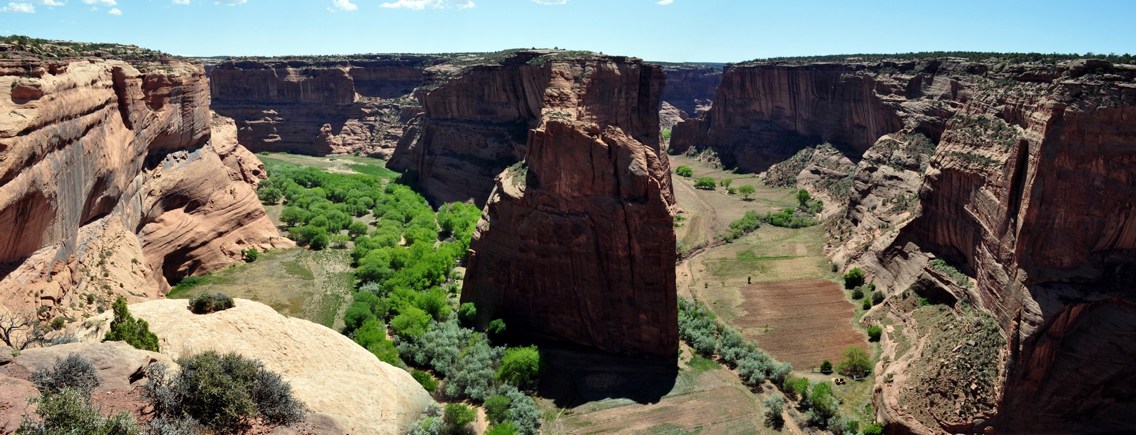
 Well, in early 2011 I came across a book in the public library in Bromsgrove (in Worcestershire where I used to live) about US army officer, Indian fighter, explorer and adventurer, Colonel Christopher Houston ‘Kit’ Carson (1809-1868). Kit Carson was a western ‘hero’ of my boyhood, a figure in popular western culture and myth.


")


 Over recent weeks, Steph and I have been enjoying the latest series of


 Or the foundations of the


 As I approach my 73rd birthday, I find myself inevitably reminiscing about the places I’ve been, the wonders (both natural and man-made) I’ve seen, and the people I’ve met in the more than 60 countries (


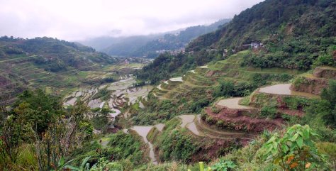


 Professor Brian Ford-Lloyd and I were graduate students together, colleagues at the University of Birmingham during the 1980s, and collaborating research scientists during the years at IRRI. Since we both lived in Bromsgrove, we would travel together into the university each day. We’ve published three books on genetic resources together. Following my retirement in 2010, Brian and I would meet up every few weeks to enjoy a pint of beer or three at our local pub, the Red Lion, in Bromsgrove where we both lived. Until that is I moved away from Bromsgrove to the northeast of England almost a year ago.


 2020 was meant to be a positive year of change. In early January we placed our house in Bromsgrove, Worcestershire on the market, with the hope (expectation?) of a quick sale. Instead, it’s a year on hold.


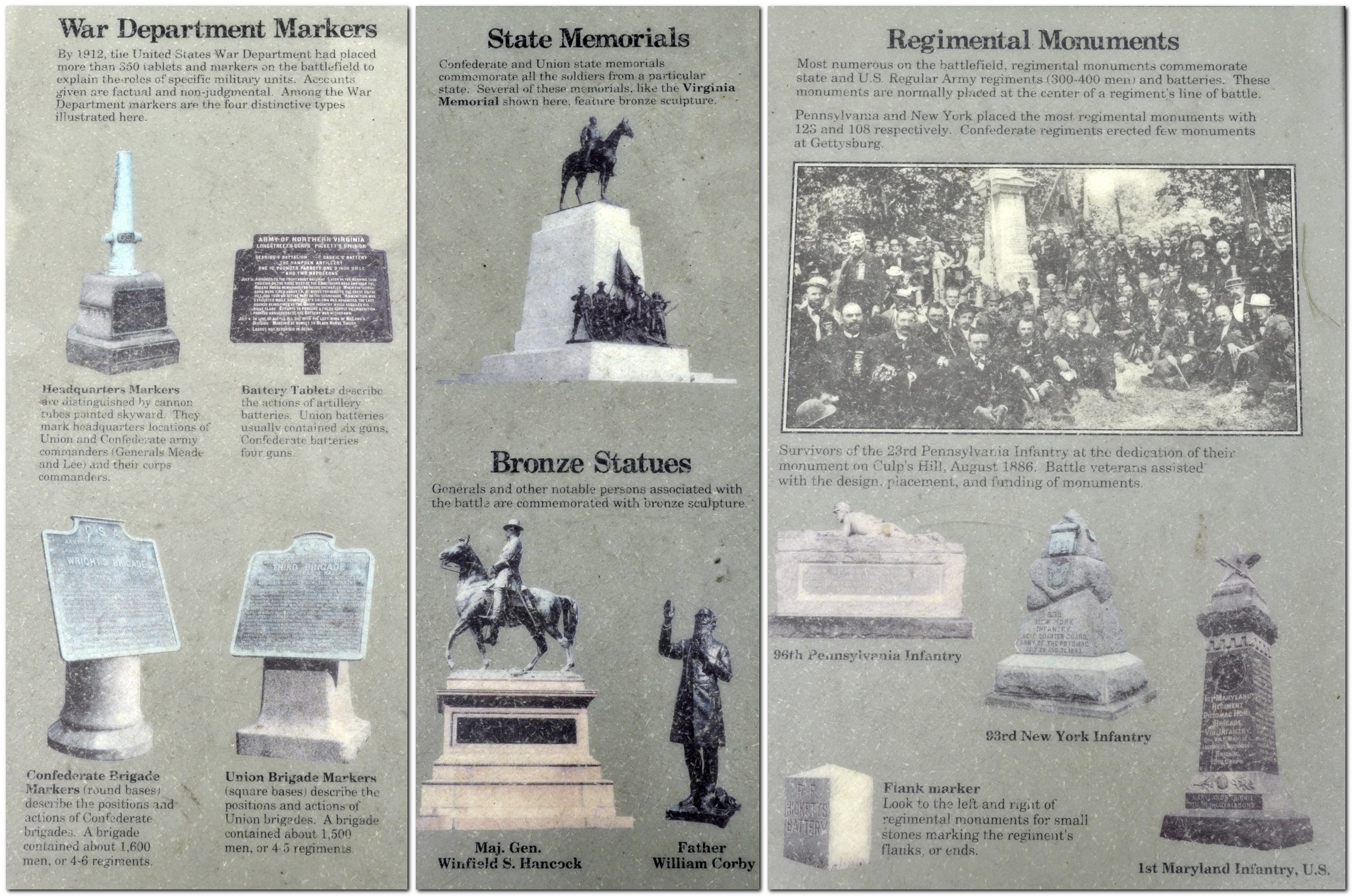


 I took my first flight, in the summer of 1966 when I was seventeen. Fifty-three years ago.


 The whole trip covered more than 17,000 nm.


 Steph and I really enjoy our visits to the USA. Over the years, we have experienced much of what this beautiful, fascinating, diverse, challenging, often bewildering (to the outsider, at least), and HUGE (or should that be ‘yuge’?) country has to offer.


 My son-in-law, Michael, is – like me – a beer aficionado, and keeps a well-stocked cellar of many different beers. It’s wonderful to see how the beer culture has blossomed in the USA, no longer just Budweiser or Coors. I had opportunity to enjoy a variety of beers. Those IPAs are so good, if not a little hoppy sometimes. However, my 2018 favorite was a Czech-style pilsener,


 Despite its incredibly bloody outcomes and destructive consequences, the American Civil War, 1861-65 holds a certain fascination. To a large extent, it was the first war to be extensively documented photographically, many of the images coming from the lens of


 takes some getting used to. I now understand that unless it specifically states not to turn, it’s OK to make that turn. Not something we’re used to in the UK. Red means red! And also, having to be aware that if you turn right on a red light, there may be pedestrians crossing as they will have right of way.

