Well, we booked our flights way back at the beginning of January. And here we are, five months later, in St Paul, Minnesota for a month-long vacation with our elder daughter Hannah and her family.
Our trip started very early last Thursday (9 May). I’d booked a local taxi for 03:30 to take us to Newcastle International Airport (NCL) for the flight to Amsterdam (AMS), so had the alarm set for 02:30. Just ten minutes before the scheduled pick-up time, I received a message on a phone app with the name of the driver, make and registration of the car, and when he would arrive. Imminently!
The roads were quiet at that time of the morning, as expected, and the 11 mile drive to the airport took less than 20 minutes.
All went smoothly at the KLM check-in; there was no-one in the queue ahead of us. Unlike last year when it was mayhem at NCL.
We quickly cleared security but then had to wait until 05:30 for the gate to open.
Once on board, the captain announced there would be a delay for about 1 hour due to fog at Schipol. Groans all round! But then, just five minutes later, he announced the good news that the weather had improved in AMS, and our flight had been given clearance to depart.
KLM operated a Boeing 737-800 (registration PH-BGC) on this sector.
It was bright and sunny, warm even, when we landed in AMS, around 08:20, but there was a very long taxi (around 15 minutes) to Gate D44.
Our connecting Delta flight (DL161) to MSP left from Gate E3 at 10:15. Schipol is a huge airport, and even with walkways it can take many minutes to walk from one gate to another. But as we’d arrived on time, we ‘enjoyed’ a leisurely stroll to our gate. Unlike last year when our arrival into AMS was delayed by more than 1 hour and we had to rush, arriving at the departure gate just as the flight was boarding. And as I’m still having some mobility issues, I was relieved we had the extra minutes this year.
Delta operated an Airbus A330-300 (registration N821NW) on this route. As with previous years we booked Delta Comfort+ seats. We enjoy the slightly bigger space and seat recline (and dedicated overhead bin space). And in the 2-4-2 seat configuration, window and aisle seats are a good choice for us. On the return journey last year, from Detroit (DTW) to AMS, I used airmiles to upgrade to Premium Economy. Not worth it!
The flight was almost completely full, yet despite that boarding proceeded smoothly and we actually departed about 10 minutes ahead of schedule.
This was one of the smoothest flights I’ve had over the North Atlantic, and although I never can sleep well on any flight, I must have snatched some, helped by a couple of these with my lunch, and another with a snack later on.
On arrival at MSP (Gate G2), at 11:40 (about 40 minutes ahead of schedule), there was quite a long walk from the plane to Immigration. With just a couple of passengers ahead of us in the queue, we sailed through, and both our bags arrived within 10 minutes. Hannah and Michael were waiting for us, and since they live just 4 miles (and around 9 minutes) from MSP, we were home by about 12:30 and soon enjoying a refreshing cup of tea.
In 2023 we visited the US for the first time since 2019 and made just a short road trip overnight to meet up with old friends Norma and Roger Rowe in La Crosse, Wisconsin. It was in September 2019 that we made our last long road trip, and I ‘vowed’ it would be our last. Until we agreed to make another trip this year. Who knows what’s in store in 2025?
Anyway, we’re flying out to Las Vegas (LAS) next Tuesday to begin a road trip of around 1800 miles across Utah and Colorado, visiting several national parks along the way: Kolob Canyon, Zion, Bryce, Arches, and Canyonlands in Utah, and Mesa Verde and Florissant Fossil Beds National Monument in Colorado. I’ve chosen some exciting (challenging, even) routes through the Rockies, taking in the ‘Million Dollar Highway’, weather permitting. And stopping off at the Hoover Dam in Nevada on the first day.
This is our planned route that will be subject to changes depending on road conditions at the time. But we do have all our overnight stops booked, so that much remains fixed.
Then, a week later, we’ll fly back to MSP from Denver (DEN).
Yesterday, we visited the Minnesota Valley National Wildlife Refuge (just 6 miles from Hannah’s house) to purchase an America the Beautiful National Parks and Federal Recreation Lands annual pass. At US$80 (=£64.29) this is great value, saving probably half of what we would pay for all the individual visits on our trip, and permits entrance to all the national parks and facilities of several other federal agencies.
We also enjoyed a short walk around one of the trails near the Visitor Center, and within just a few minutes of arrival saw an incredible array of bird species. We will be returning there and to several of the other trail sites along the Minnesota River.
So look out for more posts in the coming weeks because I’ll be writing about each day’s adventures, posting lots of photographs and dashcam footage as we wend our way through the various canyons and over the mountain passes.
Fifty years ago today, Steph and I were married at the town hall (municipalidad) in the Miraflores district of Lima, where we had an apartment on Avenida José Larco. Steph had turned 24 just five days earlier; it would be my 25th in the middle of November.
Municipalidad de Miraflores, Lima
It was a brief ceremony, lasting 15 minutes at most, and a quiet affair. Just Steph and me, and our two witnesses, John and Marian Vessey. And the mayor (or other official) of course.
John, a plant pathologist working on bacterial diseases of potato, was a colleague of ours at the International Potato Center (CIP) in Lima, who had joined the center a few months before I arrived in Lima in January 1973.
Enjoying pre-lunch drinks with Marian and John at ‘La Granja Azul‘ restaurant at Santa Clara – Ate, on the outskirts of Lima.
Steph arrived in Birmingham in September 1971, just after I had finished the one-year course. I was expecting imminently to head off to Peru where I had been offered a position at CIP to help curate the large collection of native potato varieties in the CIP genebank. So, had I flown off to South America then, our paths would have hardly crossed.
But fate stepped in I guess.
My departure to Peru was delayed until January 1973. So I registered for a PhD with renowned potato expert Professor Jack Hawkes (right, head of the Department of Botany and architect of the MSc course), and began my research in Birmingham while CIP’s Director General, Richard Sawyer, negotiated a financial package from the British government to support the center’s research for development agenda, and my work there in particular.
It must have been early summer 1972 that Steph and I first got together. Having completed the MSc written exams in May, Steph began a research project on reproductive strategies in three legume species, directed by Dr Trevor Williams (who had supervised my project a year earlier on lentils). And she completed the course in September.
By then, she had successfully applied for a scientific officer position at the Scottish Plant Breeding Station in Edinburgh (SPBS, now part—after several interim phases—of the James Hutton Institute in Dundee), as Assistant Curator of the Commonwealth Potato Collection. But that position wasn’t due to start until November.
Our VW Variant in Peru, around May 1973 – before receiving a Peruvian registration plate.
In early November I took delivery of a left-hand-drive Volkswagen for shipment to Peru. On a rather dismal Birmingham morning, we loaded up the VW with Steph’s belongings and headed north to Edinburgh. She returned to Birmingham in mid-December for her graduation.
Then, just after Christmas 1972, we met up in a London for a couple of days before I was due to fly out to Lima.
At that time we could not make any firm commitments although we knew that—given the opportunity—we wanted to be together.
Again fate stepped in. On 4 January 1973, Jack Hawkes and I flew to Lima. Jack had been asked to organize a planning conference to guide CIP’s program to collect and conserve native Andean potato varieties and their wild relatives.
Potato varieties from the Andes of Peru.
While I stayed in a small hotel (the Pensión Beech, in the San Isidro district) until I could find an apartment to rent, Jack stayed with Richard Sawyer and his wife Norma. And it was over dinner one evening that Jack mentioned to Richard that I had a ‘significant other’ in the UK, also working on potato genetic resources, and was there a possibility of finding a position at CIP for her. Richard mulled the idea over, and quickly reached a decision: he offered Steph a position in the Breeding and Genetics Department to work with the germplasm collection.
With that, Steph resigned from the SPBS and made plans to move to Lima in July, with us planning to get married later on in the year.
In the CIP germplasm screenhouses in La Molina. Bottom: with Peruvian potato expert Ing. Carlos Ochoa.
A couple of weeks after I arrived in Peru, I found an apartment in Miraflores at 156 Los Pinos (how that whole area has changed in the intervening 50 years), and that’s where Steph joined me.
In our Los Pinos apartment, Miraflores in July 1973.
A few weeks later we found a larger apartment, nearby at 730 Avda. Larco, apartment 1003. Very interesting during earthquakes!
Around mid-August 1973 we began the paperwork (all those tramites!) to marry in Peru. Not as simple as you might think, but on reflection perhaps not as difficult as we anticipated.
While we were allowed to post marriage banns in the British Embassy, we had to announce our intention to marry in the official Peruvian government gazette, El Peruano, and one of the principal daily broadsheets (El Comercio if memory serves me right), and have the police visit us at our apartment to verify our address. I think we also had to have blood tests as well. This all took time, but everything was eventually in place for us to set the wedding date: 13 October.
Some friends wanted to give us a big wedding, but Steph said she just wanted an intimate, quiet day. So that’s what we organized.
In the week leading up to our wedding, we had to present all the notarised documents at the municipality. After the ceremony, we signed the registry, hand-written in enormous volumes (or tomos). There was a bank of clerical staff, all with their Parker fountain pens, inscribing the details of each wedding in their respective tomo. A week later we collected our Constancia de Matrimonio (with some errors) which detailed in which tomo (No. 83, page 706) our marriage had been recorded, as well as photocopies (now sadly faded) of the actual page.
My work, collecting potatoes, took me all over the Andes; not so much for Steph who only made visits every other week or so to CIP’s highland experiment station (at over 3000 masl) in Huancayo east of Lima, and a six hour drive away.
However, Steph and I explored Peru together as much as we could, taking our VW on several long trips, to the north and central Andes, and south to Lake Titicaca. We also delayed our honeymoon until December 1973, flying to Cusco for a few days, and spending one night at Machu Picchu.
At Machu Picchu, December 1973.
In May 1975, we returned to the UK for seven months for me to complete my PhD, returning to Lima just before New Year.
With Jack Hakes and Trevor Williams at my PhD graduation on 12 December 1975 at the University of Birmingham.
Christmas Day 1976 in Turrialba.
Then, in April 1976, we moved to Costa Rica where I worked on potato diseases and production, based in Turrialba, some 70 km east of the capital city, San José. Under the terms of our visas, Steph was not permitted to work in Costa Rica. I became regional representative for CIP’s Region II (Mexico, Central America, and the Caribbean) in August 1997 when my colleague, Oscar Hidalgo (who was based in Toluca, Mexico) headed to North Carolina to begin his PhD studies.
Our elder daughter Hannah Louise was born in San José in April 1978. Later that year, we took our first home leave in the UK and both sets of grandparents were delighted to meet their first granddaughter.
24 April 1978 in the Clinica Santa Rita, San José, Costa Rica.
On home leave in the UK in September 1978.
With Steph’s parents Myrtle and Arthur (top) in Southend-on-Sea, and mine, Lilian and Fred, in Leek.
We spent five happy years in Costa Rica before moving back to Lima at the end of November 1980, and began making plans to move to the Philippines by Easter 1981.
However, in early 1981, a lectureship was created at the University of Birmingham, in the Department of Plant Biology (formerly Botany, where Steph and I had studied), for which I successfully applied. We left CIP at the end of March and had set up home in Bromsgrove (about 13 miles south of Birmingham in north Worcestershire) by the beginning of July.
4 Davenport Drive
A decade after we were married, we were already a family of four. In May 1982 Philippa Alice was born in Bromsgrove.
30 May 1982 in Bromsgrove hospital.
During the 1980s we enjoyed many family holidays, including this one in 1983 on the canals close to home.
Many other family holidays followed, in South Wales, in Norfolk, on the North York Moors, and in 1989, in the Canary Islands.
In Tenerife, Canary Islands in July 1989. Steph is carrying the binoculars that I bought around 1964 and which I still possess.
Hannah (left) and Philippa (right) thrived at local Finstall First School, shown here on their first day of school in 1983 and 1987, respectively.
My work at Birmingham kept me very busy (perhaps too busy), but I particularly enjoyed working with my graduate students (many of them from overseas), and my undergraduate tutees.
All in all, it looked like Birmingham would be a job for life. That was not to be, however. By the end of the 1980s, academic life had sadly lost much of its allure, thanks in no small part to the policies and actions of the Thatcher government. We moved on.
By 1993, we had already been in the Philippines for almost two years, where I had been hired (from July 1991) as head of the Genetic Resources Center (GRC) at the International Rice Research Institute (IRRI) in Los Baños, some 65 km south of Manila in the Philippines. I moved there ahead of Steph and the girls (then aged 13 and nine) who joined me just after Christmas 1991.
Meeting fellow newcomer and head of communications, Ted Hutchcroft and his wife at our joint IRRI welcoming party in early 1992.
In 1993 I learned to scuba dive, a year after Hannah, and it was one of the best things I’ve ever done. Philippa trained a couple of years later.
Getting ready to dive, at Arthur’s Place, Anilao, Philippines in January 2003.
Steph was quite content simply to snorkel or beachcomb, and we derived great pleasure from our weekends away (about eight or nine a year) at Anilao, 92 km south from Los Baños. In fact, our weekends in Anilao were one of our greatest enjoyments during the 19 years we spent in the Philippines.
Steph became an enthusiastic beader and has made several hundred pieces of jewelry since then. In Los Baños we had a live-in helper, Lilia, and so in the heat of Los Baños, Steph was spared the drudgery of housework or cooking, and could focus on the hobbies she enjoyed, including a daily swim in the IRRI pool, and looking after her garden and orchids.
Steph and Lilia on our last day in IRRI Staff Housing #15 on 30 April 2010.
Hannah and Philippa completed their school education at the International School Manila (ISM) in 1995 and 1999 respectively, both passing the International Baccalaureate Diploma with commendably high scores.
Graduation at ISM: Hannah and Philippa with their friends from around the world.
Traveling to Manila each day from Los Baños had not been an easy journey, due to continual roadworks and indescribable traffic. It was at least two hours each way. By the time Philippa finished school in 1999, the buses were leaving Los Baños at 04:30 in order to reach Manila by the start of classes at 07:15.
In October 1996, Hannah started her university degree in psychology and social anthropology at Swansea University in the UK. However, after two years, she transferred to Macalester College, a highly-rated liberal arts college in St Paul, Minnesota, graduating summa cum laude in psychology and anthropology in May 2000. She then registered for a PhD in industrial and organizational psychology at the University of Minnesota. Philippa began her BSc degree in psychology at the prestigious University of Durham, UK later that same year, in October.
Hannah’s graduation in May 2000 at Macalester College, with Philippa and Michael (Hannah’s boyfriend, now her husband).
Once Hannah and Philippa had left for university, IRRI paid for return visits each year, especially at Christmas.
Christmas 2001. Michael joined Hannah for the visit.
While my work took me outside the Philippines quite often, Steph and I did manage holidays together in Hong Kong/Macau and Australia. And, together with Philippa, we toured Angkor Wat in Cambodia in December 2000.
But Steph also accompanied me on work trips to Laos, Bali, and Japan. She also joined me and my staff when we visited the rice terraces in northern Luzon in March 2009.
Enjoying a cold beer as the sun goes down, near Sagada, northern Luzon, Philippines.
Overlooking the Batad rice terraces in northern Luzon in March 2009.
However, we always used our annual home leave allowance to return to the UK, stay in our home in Bromsgrove (which we had purposely left unoccupied), and meet up with family and friends.
Philippa was awarded a 2:1 degree in July 2003, and the graduation ceremony took place inside Durham Cathedral. She then headed off to Vancouver for a year, before returning to the UK and looking for a job, eventually settling in Newcastle upon Tyne where she has lived ever since.
Outside Durham Cathedral where Phil received her BSc degree from the university’s Chancellor, the late Sir Peter Ustinov.
Hannah married Michael in May 2006, and finished her PhD. We flew to Minnesota from the Philippines.
15 May 2006, at the Marjorie McNeely Conservatory in Como Park, St Paul.
PhD graduation at the University of Minnesota.
Philippa registered for a PhD in biological psychology at Northumbria University in Newcastle upon Tyne where she was already working.
Professionally, the period between 2001 and my retirement in 2010 was the most satisfying. I had changed positions at IRRI in May, moving from GRC to join the institute’s senior management team as Director for Program Planning and Communications (DPPC). I worked with a great team, and we really made an impact to increase donor support for IRRI’s research program. However, by 2008/9 when my contract was up for renewal, Steph and I had already agreed not to continue with IRRI, but take early retirement and return to the UK.
But as our retirement date approached in April 2010, I was honored by the institute’s Board of Trustees with a farewell party (despedida) coinciding with the 50th anniversary of the very first Board meeting in April 1960.
14 April 2010 – IRRI’s 50th celebration dinner and our despedida.
Friday 30 April was my last day in the office.
With my DPPC friends. L-R: Eric, Corinta, Zeny, me, Vhel, and Yeyet.
We flew back to the UK two days later, arriving on Monday 3 May and taking delivery of our new car, a Peugeot 308, the following day.
Philippa and Andi flew off to New York in October 2010 and were married in Central Park. She graduated with her PhD in December.
By 2013 we had been married for four decades, and were well-settled into retirement, enjoying all the opportunities good weather gave us to really explore Worcestershire and neighboring counties, especially as National Trust and English Heritage members. And touring Scotland in 2015, Northern Ireland in 2017, Cornwall in 2018, East Sussex and Kent in 2019, and Hampshire and West Sussex in 2022.
We were, by then, the proud grandparents of three beautiful boys and a girl.
Callum Andrew (August 2010) – St Paul, Minnesota
Elvis Dexter (September 2011) – Newcastle upon Tyne
Zoë Isobel (May 2012) – St Paul, Minnesota
Felix Sylvester (September 2013) – Newcastle upon Tyne
And how could we ever forget a very special day in February 2012, when Steph, Philippa and my former colleague from IRRI, Corinta joined me at Buckingham Palace for an investiture.
Receiving my OBE from King Charles III (then HRH The Prince of Wales) on 14 February 2012.
With Steph and Philippa outside the gates of Buckingham Palace.
With Corinta and Steph in the courtyard of Buckingham Palace after the investiture.
Since 2010, we have traveled to the USA each year except during the pandemic years (2020-2022), and only returning there this past May and June. We’ve made some pretty impressive road trips around the USA, taking in the east and west coasts, and all points in between with the exception of the Deep South. Just click here to find a list of those road trips.
In July 2016, a few months after I broke my leg, Hannah and family came over to the UK, and we got together with Phil and Andi and the boys for the first time, sharing a house in the New Forest.
Our first group photo as a family, near Beaulieu Road station in the New Forest, 7 July 2016. L-R: Zoë, Michael, me (still using a walking stick), Steph, Callum, Hannah, Elvis, Andi, Felix, and Philippa.
And they came over again in July 2022, to our new home in the northeast of England where we had moved from Bromsgrove in October 2020 at the height of the Covid-19 pandemic.
In our garden in Backworth, North Tyneside, August 2022.
L-R: Felix, Elvis, Zoë, and Callum, at Dunstanburgh Castle, Northumberland in August 2022.
So it’s 2023, and fifty years have passed since we married.
During our visit to the USA this past May and June, we met up with Roger Rowe and his wife Norma, along the Mississippi River at La Crosse in Wisconsin.
Roger joined CIP in 1973 as head of the Breeding and Genetics Department and was our first boss. Roger also co-supervised my PhD. So it was great meeting up with them again 50 years on.
We’ve been in the northeast just over three years now, and haven’t regretted for a moment making the move north. It’s a wonderful part of the country, and in fact has given us a new lease of life.
At Steel Rigg looking east towards the Whin Sill, Crag Lough, and Hadrian’s Wall, Northumberland, February 2022.
Steph has taken great pleasure in developing her new garden here. It’s a work in progress, and quite a different challenge from her garden in Worcestershire, discovering what she can grow and what won’t survive this far north or in the very heavy (and often waterlogged) soil.
22 August 2023
I’ve had much enjoyment writing this blog since 2012, combining my interests of writing and photography. It has certainly given me a focus in retirement. I never thought I’d still be writing as many stories, over 700 now, and approaching 780,000 words. Since returning to the UK, I’ve also tried to take a daily walk of 2-4 miles. However, that’s not been possible these past six months. A back and leg problem has curtailed my daily walk, but I’m hopeful that it will eventually resolve itself and I’ll be able to get out and about locally, especially along the famous North Tyneside waggonways.
After 50 years together, we have much to be thankful for. We’ve enjoyed the countries where we have lived and worked, or visited on vacation. Our daughters and their families are thriving. Hannah is a Senior Director of Talent Management and Strategy for one of the USA’s largest food companies, and Philippa is an Associate Professor of Biological Psychology at Northumbria University.
Sisters!
With Hannah and Michael, Callum and Zoë (and doggies Bo and Ollie, and cat Hobbes) in St Paul, MN on 18 June 2023.
With Philippa and Andi, Elvis and Felix (and doggies Rex and Noodle) on 2 September 2023.
And here we are, at South Stack cliffs, in the prime of life (taken in mid-September) when we enjoyed a short break in North Wales.
Steph with Philippa and family on her birthday on 8 October.
13 October 2023 – still going strong!
While drafting this reminiscence, I came across this article by Hannah Snyder on the Northwest Public Broadcasting website, and it inspired the title I used.
I have been very fortunate. There’s no denying. Since I made my first trip outside the UK, to the west coast of Ireland for a botany field course in July 1968, followed a year later, in September 1969 to participate in a folk festival in Czechoslovakia, I’ve had so many opportunities to travel around the globe—to more than 60 countries (sometimes on vacation, but mostly on business associated with my work in international agricultural research).
Morris dancing at the folk festival in Strakonice, Czechoslovakia in 1969. That’s me on the extreme right.
I’ve lived and worked in three countries (besides the UK of course): Peru (1973-76); Costa Rica (1976-1980); and the Philippines (1991-2010). I’ve visited several countries multiple times, and others just the once. Whenever I was traveling on business, I would also try to fit in some tourism over a weekend if possible. I have so many memories over those 55 years. Here are some that spring to mind.
The Americas I guess I should begin this section with Peru. In 1971 I was thrilled to be offered a job in Peru, at the newly-founded International Potato Center (CIP), although I didn’t actually travel there until January 1973.
13 October 1973
So many memories. Steph and I were married in Lima in October 1973.
Looking at a farmer’s field of potatoes in the Mantaro Valley near Huancayo.
Solanum lignicaule, 2n=2x=24, from southern Peru
In Pisac market
The street of the thirteen-sided stone.
Cuzco cathedral.
School time.
North of Ayacucho, but before the Mantaro gorge.
Arequipa’s cathedral with El Misti in the background.
On the river near Puerto Bermudez
Near Cuzco in southern Peru, 1974
Machu Picchu
Sacsayhuaman at Cuzco
It’s almost impossible to choose any one aspect that stands out. The diversity of landscapes, with desert on the coast, the high Andes, and the jungle on the eastern side. The long history of agriculture in difficult environments, and the archaeology of civilizations that go way back before the invasion by the Spanish in the 16th century.
Then we moved to Costa Rica in April 1976, living in Turrialba, about 70 km east of the capita, San José. Once again I was working on potatoes and with farmers.
We enjoyed our five years in that beautiful country, and our elder daughter Hannah was born there in April 1978.
A land of volcanoes (some very active), Costa Rica is a verdant country, and there are national parks everywhere. The bird and plant life is extraordinary, so I guess this is what stands out for me in particular.
Potato fields of var. Atzimba on the slopes of the Irazu volcano
Northern Costa Rica on the way to Monteverde.
Just after we’d taken delivery of our VW Brasilia
Typical ox carts in Costa Rica
Steph and Hannah at the Monteverde Biological Reserve
A respendent quetzal that we saw at Monteverde
Carrying Hannah on my back at Monteverde
Tamarindo Beach on the Guanacaste coast in northwest Costa Rica
CATIE in Turrialba
The Turrialba volcano from our garden at CATIE
Hannah growing up at CATIE
On a visit to the Poas volcano
My work took me to all the countries of Central America, as well as to Mexico where, until 1977, CIP’s regional headquarters was based just outside Mexico City at Toluca. And also out into the Caribbean islands, to Haiti and the Dominican Republic, to Jamaica, St Kitts, Antigua, Montserrat, Barbados, and Trinidad.
In Mexico, most of my visits were to Toluca. But on one visit there, I joined the participants of a potato training course to study potato production in Mexico State, Michoacán, Puebla, Jalisco, and Guanajuato. Later, in the 1980s I also visited Nuevo Leon in the north, and Morelos south of Mexico City.
But if I had to choose one highlight, it would be the pyramids at Teotihuacán, northeast of Mexico City that Steph and visited in 1975 when we visited some friends at CIMMYT (a sister center to CIP) on our way back to the UK.
Guatemala is a fascinating and beautiful country, and I was a regular visitor. A land of lakes and volcanoes, it has a high indigenous population, who wear the most colorful fabrics.
In 1977, Steph and I flew into the Mayan city of Tikal, deep in the jungle, for an overnight stay.
On another trip I spent a few days in Belize, first in Belize City on the coast, then in Belmopan, the smallest capital city in the Americas.
The overriding memory I have of Honduras was the white-knuckle landings in Tegucigalpa. How they managed to land jets there is beyond me. What pilot skill!
I visited El Salvador and Nicaragua just once each, and then only overnight. They had virtually no potato sector.
Flying in and out of Panama City was quite a regular occurrence. It was a transit for Costa Rica from South America. The main potato area was in the west of the country near the frontier with Costa Rica (map), north of the city of David at Volcán and Boquete. A region of deep volcanic soils, it was very good potato-growing country, and one I traveled to by road from my base in Turrialba on a couple of occasions.
Potato fields in Boquete, northern Panama
It was only after I moved to the Philippines in 1991 that my work took me back to Costa Rica for the first time in about 15 years, and one other country, Venezuela, which I’d not visited before although landing at Caracas airport on several occasions. This airport is located on the Caribbean coast north of the city, and is connected by a 27 km motorway that crosses the mountains, a spectacular drive over what I assume is a northern extension of the Andes.
In the 1990s I spent a week in Caracas attending a potato network meeting, but seeing very little of the city, just the metro from hotel to meeting venue and back!
Another international agricultural research center in Cali, Colombia is CIAT (map), supported in the same way as CIP and CIMMYT (and the rice institute, IRRI, in the Philippines, that I joined in 1991). Located in the Cauca Valley, CIAT is surrounded by huge plantations of sugar cane, but the rice-growing area is nearby as well. The last time I was there (and in Peru and Mexico) was in July 2016 conducting a review of the CIAT genebank.
I was in Chile just the once, for a week in Santiago in July 1979. I’d flown down from Costa Rica to join two colleagues from Lima to carry out a short review of the Chilean potato program. Two things come to mind: wine and ABBA. Wine, because we were taken to dinner at Enoteca, a fine restaurant overlooking the city on Camino Real, where all the wines produced in Chile were on display, and we were invited to sample many of them. On one evening, while out enjoying some souvenir shopping, I heard (for the first time) the refrains of Chiquitita by ABBA emitting from one of the shops. My visit to Santiago will always be associated with ABBA.
What can I say about Brazil? It’s huge. My first visit there was in 1979 when I attended a potato conference at Poços de Caldas in Minas Gerais (map), followed by a couple of nights in Rio de Janeiro. On another occasion I attended a conference in Foz do Iguaçu (in Paraná state) close to the border with Argentina and Paraguay, and site of the impressive Iguazu Falls.
I’ve been to Brasilia twice, and once upon a time, that nearly became home for Steph and me when CIP’s Director General deliberated whether to post me to Brazil or the Philippines. In the event we returned to the UK in 1981 when I joined the faculty of the University of Birmingham.
I guess the most impressive thing I’ve experienced in Brazil is the statue of Christ at Corcovado, high above Rio de Janeiro, with the most spectacular views over the city. My dad was there in the 1930s.
I’ve been to Canada twice, the first time in 1979 (with Steph and 15 month-old Hannah) when I attended a potato conference in Vancouver, then we drove across the Rockies to meet up with my late elder brother Ed and his wife Linda in Edmonton, AB.
In the early 2000s, I made a short visit to Ottawa to meet with representatives of Canadian overseas development assistance agencies, and managed to spend a day getting to know the city, before heading back to the USA.
Parliament Hill from the banks of the Ottawa River
Over the decades I’ve traveled to the USA many times, and have now visited all states and DC except Hawaii, Alaska (although one flight touched down in Anchorage), Idaho, Nevada (I changed flights in Las Vegas), Oklahoma, Kansas, North Dakota, Louisiana, Mississippi, and Alabama. It’s such a vast country, but since 2011, Steph and I have managed several mega road trips and seen so many wonderful sights. It’s hard to pick any one. I have written about these trips and you can find a link here; just scroll down to the USA section).
However, I’ve often said since we made the visit there in 2011, that if I ever got the opportunity to return, it would be to Canyon de Chelly in northeast Arizona. It’s a special place.
Canyon de Chelly, AZ
Spider Rock in the Canyon de Chelly
There’s not a lot of potatoes grown throughout the Caribbean, with only the Dominican Republic having any significant potato program, in the central highlands close to the border with Haiti. The Dominican Republic became one of the founder members of a regional potato program, PRECODEPA, set up in 1978, so I guess I must have traveled there five or six times.
I was just the once in Haiti, in the late 1970s attending a conference for about a week. We stayed in a nice hotel overlooking Port-au-Prince, and ventured out into the city just the once. Even then the city was not a safe place to wander round, and following the disastrous 2010 earthquake followed by the cholera outbreak, the country has become even more ungovernable, and not somewhere I would want to visit again. It’s one of the poorest countries in the Western Hemisphere.
I also paid short visits to Jamaica, St Kitts, Montserrat (which had a small but thriving potato sector before the Soufrière Hills volcano erupted in 1995, covering half the island with ash), Barbados, and Trinidad. Before long-haul jets could make the flight direct from Europe to South America, Antigua was a refuelling stop, which I made a couple of times. And after being being bumped off a flight to Montserrat, I spent the night in Antigua at a luxury resort (the only hotel bed I could find on the island!) and enjoying a delicious lobster dinner for the same price as a steak.
My first trip to Asia, to Indonesia in fact, was in the early 1980s, when I attended a genetic resources meeting in Jakarta, but spending a weekend at the Bogor Botanical Garden beforehand. The oil palm tree on the right below is one of the original trees introduced into Asia and became the foundation of the oil palm industry.
Bogor botanical garden
Bogor botanical garden
One of the original oil palms in the garden
Over the 19 years I spent living in the Philippines, I returned to Indonesia several times, the most memorable being in September 2005 when the IRRI Board of Trustees held one of it bi-yearly meetings there. Steph was able to join me on that trip, and along with excursions into the Bali countryside, we also enjoyed a long weekend break at our hotel before returning to the Philippines.
Bali landscape, Indonesia
In the Philippines, we lived in Los Baños, some 60 km south of Manila, where IRRI had its research center.
On the IRRI experiment station, with Mt Makiling (a dormant volcano) in the background.
Although we didn’t travel much around the Philippines (and apart from one short trip to Cebu, we didn’t wander beyond the island of Luzon), we went to the beach most months, and in March 2009, Steph joined me and my DPPC staff when we took an office outing over five days to the rice terraces in the mountains north of Manila. Very impressive.
Looking south towards Banaue town center.
In 1993 I learnt to scuba dive, one of the best things I’ve ever done, opening up a totally new world for me. The Philippines has some of the best diving in the world, especially at Anilao south of Manila.
Diving at Anilao, Philippines
But one of the best things about the Philippines? The Filipinos! Always smiling. Such friendly people. And I had great Filipino colleagues working with and for me in both the roles I took on at IRRI.
The ‘IRRI All Stars’ who helped during the IRRI Day in October 2002.
Colleagues from the Genetic Resources Center.
In 1995, I launched a major rice biodiversity project (funded by the Swiss government), and one of my staff, Dr Seepana Appa Rao was recruited to help the national rice program in Laos to collect native varieties of rice. Over five years, I visited Laos at least twice a year, taking part several times in a baci ceremony to welcome me to the country, and other visitors as well. Steph joined me on one trip, and here we are during one such ceremony at the house of my colleague, the late Dr John Schiller.
On that particular trip, we took a weekend off, flying to Luang Prabang and enjoying a river trip on the Mekong.
Mekong River, nr. Luang Prabang, Laos
IRRI had a country program in Cambodia, and I visited a couple of times to discuss rice germplasm conservation, and stayed in Phnom Penh. But after Christmas 2000, Steph and I were joined by our younger daughter Philippa (who had just begun her undergraduate studies at the University of Durham in the UK) for a mini-break in Cambodia (and Singapore).
We flew from Phnom Penh to Siem Reap, and spent three nights there visiting the amazing Angkor Wat temple complex, and a boat trip on the Tonle Sap, before flying back to the capital for one night, and back to Singapore.
We celebrated the New Year in Singapore, taking in the beautiful botanic gardens. Work has taken me to Singapore on several occasions, and Changi airport has to be one of the world’s aviation destinations. How it must have changed since I was last there.
Work took me to Seoul in South Korea on several occasions, and Japan. Steph joined me on one trip to Japan in September 2009 when the IRRI Board of Trustees met in Tsukuba north of Tokyo. We stayed on for a long weekend sightseeing in Tokyo, although she got to see more than I did earlier in the week, when a series of excursions for IRRI and Trustee wives were organised from Tsukuba.
Narita airport was also a hub for Northwest Airlines (now Delta) for flights from Manila to the USA, so I would fly through there at least a couple of times a year, also Osaka.
I’ve been to Beijing in China a couple of times, taking in the Great Wall during my first visit in 1995.
With my colleague, Bao-Rong Lu (middle) on the Great Wall, north of Beijing
On that trip we also took in Hangzhou and Guangzhou. I was in Beijing again around 2005 for a meeting, and in 2004, Steph and I flew to Hong Kong over Christmas and New Year. We also crossed to Macau on that trip.
The view from Victoria Peak, Hong Kong
Ruins of St Paul’s, Macau
Again, Hong Kong was one of those hub airports that I passed through many times, first at the old Kai Tak airport alongside Kowloon harbor (an interesting approach), and later at the new airport reclaimed from the sea.
I’ve only been to India a handful of times, always to meetings, and only then to Delhi and Hyderabad, so I can’t say that I’ve ever seen much of the country. There’s no doubt it’s a fascinating country, but I’m not sure it’s really on my bucket list – except if I could travel on one of those luxury trains, perhaps.
The same goes for Bangladesh, with just a couple of visits to Dhaka so I can’t say that I’ve ever known the country.
I was in Sri Lanka just the once, spending most of my time in Kandy. The hotel where I stayed was outside the city, on a hill, with breath-taking views over the surrounding hills. And I remember waking up early one still morning, and listening to the bird calls echoing all around. Magic!
I been to the north and south of Vietnam. On my first trip, I traveled to Can Tho in the Mekong Delta, and on the return journey to the airport in Ho Chi Minh City, I had to cross the river in a small boat (the bridge was down) and flag down a tuk-tuk for the last 20 km or so. I caught my flight!
Then I was in Hanoi several times in connection with the rice biodiversity project, but in 2010 I was the chair of the science committee for the 3rd International Rice Congress held in that city.
Myanmar has been closed off to visitors for many years, but I was able to visit just the once in the late 1990s, to the rice genebank at Yezin, about 250 miles north of the old capital Yangon. The train ride was interminable, and the sleeper on the return journey left a lot to be desired in terms of comfort and cleanliness. Nevertheless it was an interesting visit, but compared to the cuisine of other countries in the region (especially Thailand and Indonesia) the food was not inspiring: served quite cold and swilling in oil.
I’ve been in Bangkok many times, as it where I would change flights for Vientiane in Laos, having to spend one night to catch the early morning flight on Thai or Lao Airlines. But I never got to know the country, just a couple of visits to Chiang Mai in the north (again for meetings but no tourism). The same goes for Malaysia, with meetings in Kuala Lumpur and Penang.
In 2014 IRRI once again asked me to chair the science committee for the 4th International Rice Congress that was held in Bangkok, so I made several visits there (and on to the Philippines) before the congress was held in November.
Australia
I’ve been in Australia four times. As a family, Steph, our elder daughter Hannah, Philippa and I flew from the Philippines just after Christmas 1998 to Sydney, spending just under a week there, enjoying a trip up into the Blue Mountains, and watching the awesome fireworks display over Sydney Harbour on New Year’s Eve.
I made a work trip there around 2001, taking in Canberra, the rice-growing area in the Riverina, Adelaide, and Melbourne.
In December 2003, Steph and I drove from Sydney to Melbourne over the course of a week, taking the train back to Sydney, where we enjoyed a harbour dinner cruise.
At the Sydney Harbour Bridge during our Christmas vacation in Australia in December 2003
We spent New Year’s Eve on the south coast near Melbourne.
Next stop: Antarctica
The last time I was there was November 2016, when my friend and former colleague, Professor Brian Ford-Lloyd flew from Birmingham to Melbourne for three days as part of a review of genebanks.
Enjoying a stiff one on the Emirates A380 flight from Melbourne to Dubai.
Africa
Africa now, where I have visited Morocco in the north, Ghana, Ivory Coast, and Nigeria in West Africa, Ethiopia and Kenya in East Africa, and Zambia, South Africa, Mozambique, and Madagascar in southern Africa. I wrote this general account in 2013.
There are several international agricultural research centers in Africa: ILRI (a livestock center) in Kenya and Ethiopia; World Agroforestry (ICRAF) in Kenya; IITA in Ibadan, Nigeria; and Africa Rice (WARDA) in Bouaké, Ivory Coast. I have attended meetings there on several occasions. In Ethiopia, the ILRI campus is located in Addis Ababa, and during my first visit there, in January 1993, I had the opportunity of traveling down into the Rift Valley. What I most remember about that trip, and the stay in Addis, was the incredible bird life. An ornithologist’s paradise. Likewise on the campus of IITA in Nigeria. IITA has a 1000 ha campus, and part of it has been left as pristine rainforest with its assemblage of species, some of them crop wild relatives.
Looking for wild yams on the IITA Forest Reserve.
I made my first visit to Nigeria and Ivory Coast after the genetic resources meeting in Addis Ababa in 1993. For security reasons, visitors to IITA who arrive in Lagos in the afternoon and evening spend the night there, before being escorted to Ibadan, around 2 hours by road to the northeast. I always enjoyed my visits to IITA. But Lagos airport was another thing. The situation there did improve, but throughout the 1990s, I always felt uneasy passing through, as officials (some in uniform, others in plain clothes) would often ask for a bribe.
I must have visited Ivory Coast a couple of times, the first time flying from Abidjan (the capital) to Bouaké on the national airline, a Boeing 727 that had once been the presidential aircraft! I made those visits before the disastrous civil wars of 2002-2004 and 2010-2011.
Africa Rice had to abandon its research center in Bouaké for many years, although the institute has now returned there. I planted a tree during my first visit. I wonder if it’s still there?
With Deputy Director General Perter Matlon at the tree planting.
On another occasion, I was in Ghana for a week, attending a planning meeting, and didn’t see much of Accra outside my hotel.
I’ve been in Kenya probably half a dozen times, straddled the Equator, and enjoyed the wildlife in the Nairobi National Park.
With my dear friend from CIMMYT, the late Sir Bent Skovmand (from Denmark), wheat pathologist and then head of the CIMMYT wheat genebank.
In October 2005, I was in Marrakech, Morocco to attend the annual meeting of the CGIAR, the consortium of donors and international centers. I got sick, and I had to work on a project proposal so spent much of my time in my hotel room, with just one excursion to the souk for some souvenir shopping.
Looking for silver beads for Steph.
In southern Africa, I spent several days in Lusaka, Zambia visiting the SADC genebank there. I’ve passed through Johannesburg several times, and on my transit there (on my way to Lusaka) was caught up in a car bomb incident on the day of the election that first brought Nelson Mandela to power in April 1994. On another occasion I spent a week in Durban (meetings once again) with a side trip to Pietermaritzburg, almost 90 km inland from Durban,
IRRI had a country program in Mozambique, and I was there a couple of times. The rice program joined our biodiversity project, and the CGIAR held its annual meeting there in 2009.
I was in Madagascar just the once, staying in the capital Antananarivo on the east coast, and traveling along dreadful roads north to the rice experiment station. Madagascar also participated in the rice biodiversity project.
At a training course on rice genetic resources in Madagascar in 1998.
Middle East
I had the opportunity of visiting Izmir in Turkey in April 1972, one of my first overseas trips from Birmingham, to attend a genetic resources conference. There was an excursion to Ephesus.
On another visit (also to Izmir) in the late 1970s, I spent a day in Istanbul before taking an evening flight to the UK, enjoying the Topkapi Palace and various mosques.
The Blue Mosque
I was fortunate to travel to Syria several times, to Aleppo, before the civil war pulled the country apart. Another agricultural research center, ICARDA, had its headquarters there and genebank. I even went for a job interview once. It’s a beautiful country, and I guess many of the beautiful almond orchards have probably been destroyed in the fighting. I also spent some time in Damascus, visiting the famous souk there.
In 1982, I took a party of graduate students from the University of Birmingham to Israel for a two week course on genetic resources of the Mediterranean. I wrote about that visit here.
And then there’s Dubai in the United Arab Emirates. I’ve spent a few nights there in between flights but never had enough time to explore the city. When Emirates Airlines began a service from Manila (MNL) to Dubai (DXB), and on to Birmingham (BHX), we flew that route each year on home leave, and Emirates also became my airline of choice for trips into Europe. In the 1990s it had either been with Lufthansa into Frankfurt (FRA) or KLM into Amsterdam (AMS).
Europe
Steph and I have been married almost 50 years but we’ve never taken a vacation on mainland Europe. But my work has taken me there quite often, and to three countries, Germany, Switzerland and especially Italy, several times a year between 1991 and 2010.
On that first trip to Czechoslovakia in 1969, we traveled by road, through the Netherlands, southern German, and into Czechoslovakia.
I was next in Germany in the late 1980s, when I visited agricultural research institute near Hannover (also taking in the scenic town of Celle), before crossing into East Germany. I spent several interesting days at the genebank in Gatersleben (now part of The Leibniz Institute of Plant Genetics and Crop Plant Research), before flying on to Warsaw in Poland.
There I gave a series of seminars on crop evolution and genetic conservation (focusing on potatoes) to staff of the agricultural research institute (IHAR). My hosts took me to the family home of Frédéric Chopin west of Warsaw. As we walked around the gardens, we could hear several of Chopin’s piano pieces broadcast over speakers there. His Mazurka in D Major has remained a firm favorite ever since (here interpreted by acclaimed pianist Vladimir Horowitz), and is always a reminder of that visit whenever I hear it.
I also took in Cracow in the south of the country, a most elegant city.
While I was DPPC at IRRI, my work with the institute’s donors took me many times into Europe, particularly to Germany (Bonn and Frankfurt), to Switzerland (at Bern), and to Rome in Italy.
I had a good friend, plant pathologist Dr Marlene Diekmann, who lived near Bonn, and who worked for one of the German aid agencies. Whenever I was in Bonn, we’d try and spend some time walking the wine terraces of the Ahr Valley south of Bonn.
The last time I was in Bonn was 2016 during the genebank review I mentioned earlier.
I love trains, and have often traveled that way from one European capital to another. In fact I have traveled from my former home of Bromsgrove in Worcestershire to Rome, with stops in Belgium, Germany, and Switzerland on the way.
One of the best trips I made was to view the Matterhorn in Switzerland near Zermatt. I had a free weekend before I had to travel on to Rome, so I took the opportunity of a day excursion from Bern.
My trips to France have taken in Paris, where I spent a very wet weekend once walking around the city. But it was worth it. And to Montpellier on the Mediterranean coast several times, the last being in 2016.
Brussels (in Belgium) has a beautiful central square, but I’ve never had much time to explore there.
For many years, Amsterdam was a hub airport for home leave flights back to the UK. In the Netherlands, I’ve spent time in the university town of Wageningen (east of Amsterdam), in the capital, The Hague, and in Amsterdam itself. A boat tour of the canals is well worth it.
My donor trips took me to Lisbon in Portugal and Madrid in Spain, which I wrote about in this blog post from 2019. Then in 2012, Steph and I visited my late eldest brother Martin and wife Pauline at their beautiful home in Tomar, north of Lisbon. What a glorious 10 days.
Central square in Tomar
I was in the Canary Islands (part of Spain) a couple of times, collecting various wild crop relatives. Steph, the girls, and me had a holiday there in 1989.
On the north coast of Tenerife
Looking over the Tenerife landscape.
However, the country I have visited most in Europe is Italy, and Rome in particular. I was once in the Po Valley southwest of Milan, looking at the rice research there. The Food and Agriculture Organization of the United Nations (FAO) has its headquarters in Rome, as does Bioversity International (formerly the International Plant Genetic Resources Institute, IPGRI). I guess over the 19 years I spent in the Philippines, I must have traveled to Rome at least once a year for one meeting or another, and up to five times in one year. It’s a magnificent place, although my elder daughter Hannah who has just spent a few days there commented on how dirty it was, and full of tourists. But I’ve always enjoyed my stays there, and have had ample opportunity to enjoy the history and archaeology, and the fantastic cuisine.
I’ve only been in Austria, Norway, and Denmark on one occasion each, and in the capitals Vienna, Oslo, and Copenhagen. In Vienna, I spent a week at the International Atomic Energy Agency (where they have a program in mutation breeding) consulting on germplasm databases. I visited donor agencies in Norway and Denmark, but had no time for any tourism in Oslo. It was a different situation in Copenhagen where I looked round the pretty city over a weekend.
I started this blog post in the Republic of Ireland, and Steph and I have returned there three times, two with Hannah and Philippa in the 1990s, and also in 2017 after we’d spent a little over a week touring Northern Ireland.
Northern Ireland was a revelation. Prosperous, and beautiful. We visited many National Trust properties over there, and I wrote about our 10 days there afterwards, with links in the post to many of the properties we visited.
Giant’s Causeway, Northern Ireland
In Great Britain (United Kingdom minus Northern Ireland), Steph and I have visited so many National Trust and English Heritage properties around the country. This link gives a complete list (and maps) of all those we have visited.
Since we returned to the UK in 2010, we have toured Scotland, spent time in the south and southeast of England, and in Cornwall.
South Harris beach, Outer Hebrides
Calanais Standing Stones, Isle of Lewis
Isle of Skye
Stormy weather at the Butt of Lewis
The Lizard, Cornwall
Cape Cornwall
Tintagel Castle, Cornwall
At the White Cliffs of Dover, Kent
Th whole family together for the first time, in the New Forest in 2016
South Harting from Hartin Down, West Sussex
Now that we are living in the northeast of England, we have spent time exploring Northumberland, including its incredible Roman heritage.
The Whin Sill along Hadrian’s Wall
As a small boy, I spent many holidays with my parents in different parts of Wales, and Steph and I will be returning there at the beginning of September to renew our acquaintance with North Wales after so many decades.
So, there we have it. Fifty-five years of travel. So many special experiences.
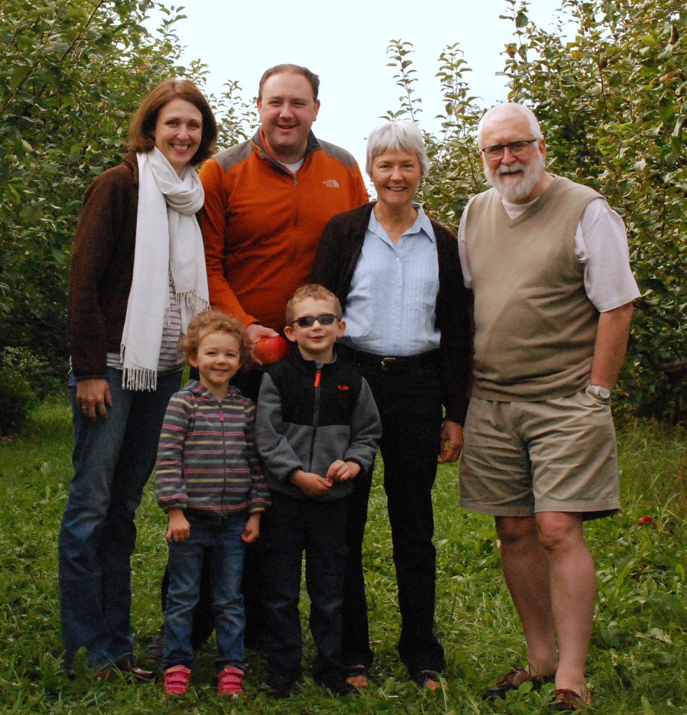
We’ve just returned from a very relaxing vacation in Minnesota, visiting our elder daughter Hannah and her family: son-in-law Michael, and grandchildren Callum (almost a teenager) and Zoë (just 11).
Our last evening in Minnesota.
Since we’d decided not to make any serious road trip this visit, apart from a short, overnight stay to La Crosse in Wisconsin, about 150 miles south of the Twin Cities, I travelled light this year. No heavy DSLR camera, no laptop. In fact, for the first time, I simply used my mobile phone for both images and video clips.
When we moved north to Newcastle upon Tyne in the autumn of 2020, I acquired a new – and better – mobile that allowed me to run many of the apps that so many utilities expect everyone to deploy these days. And, of course, the Samsung model I chose had a far better resolution camera than my Chinese cheepo.
And because of my more limited mobility right now (a painful nerve inflammation affecting my lower back, legs, and feet) Steph and I stayed close to home in St Paul, only taking our usual local walks as we’ve enjoyed in previous visits when I felt up to it. Even so, close to where Hannah and Michael live there is so much to see; their house sits at the top of the Mississippi Gorge bluff.
The weather was incredible, mostly warm (hot even) and dry. Just one afternoon of rain on Michael’s birthday when we had to postpone the planned grilling until the next day.
And talking of grilling. I can’t remember a visit when Michael fired up the BBQ or the Big Green Egg so many times, or we simply ate outside, even at the various restaurants we patronised.
Our flight from Amsterdam to Minneapolis-St Paul arrived on time on 29 May at around 12:30, and Hannah, Callum, and Zoë were waiting at the airport to meet us. Navigation through US Immigration, baggage claim, and Customs was probably the smoothest I’ve enjoyed throughout the many decades I’ve been visiting the USA. It was actually quite a pleasant experience.
So, for us, it was early evening British Summer Time, and normally Steph and I would manage to stay awake for only an hour or two before submitting to jet lag, and finally crashing. Not this time. We both had a reasonably comfortable flight over the Atlantic in Delta Comfort+, and managed some sleep.
On arrival, it was bright and sunny and warm and, being Memorial Day, everyone was at home. So we sat in the garden, enjoying a cup of tea to begin with, followed (in my case) by a couple of the fantastic local beers. There are so many to choose from these days. But more of that later.
Late afternoon, and Michael cranked up the BBQ and we enjoyed a very satisfying dinner of Von Hanson steaks, beer brats, and salad. So it must have been almost 9 pm that we admitted defeat, and headed to bed. I’ve never been over jet lag so quickly.
I now wish I’d taken more notice of the various beers I sampled – I could have tried a different beer for everyday of our stay, there are so many to choose from. There’s nothing quite like a cold, cold beer on a hot afternoon when the temperature is reaching 90ºF.
Less than a mile from Hannah and Michael’s home in the Highland Park area of St Paul (map), redevelopment of the 122 acre site of the former Ford Motor Company Twin Cities Assembly Plant (closed in 2011) began in 2020, now renamed Highland Bridge.
The local supermarket, Lunds & Byerlys has relocated a couple of blocks west along Ford Parkway to Highland Bridge. On the first floor they have opened The Mezz Taproom—with a terrace overlooking the new development—where you have the choice of about 20+ beers on tap, plus some wines. Michael took me there one blisteringly hot afternoon a few days after we arrived in St Paul.
It’s an interesting concept. There is no bar. With an electronic wrist tag (which opens the beer tap) you can sample as much or as little of any of the beers on offer, with a wide range of glass sizes and shapes to match. You just pay for the amounts consumed, which are electronically tallied. Simples!
Panorama of the Highland Bridge redevelopment, looking west.
The Highland Bridge redevelopment comprises commercial and residential units, including those for the elderly, and townhouses. Thoughtfully, and together with the St Paul Parks and Recreation department, the developers have created several parks with innovative water features that also act as storm drainage (when it rains in St Paul, it really rains). All parks cater for all ages, with paths, seating, and roller and skateboard parks, beach volleyball courts, and even a Little League pitch as well.
Gateway Park
Gateway Park
Gateway Park
Gateway Park
Gateway Park
Gateway Park
Highland Bridge River Plaza
Highland Bridge River Plaza
Highland Bridge River Plaza
Highland Bridge River Plaza
Highland Bridge River Plaza
Elderly care residences
Town houses
Steph and I took a wander (very slowly) through these. What an impressive development, even though I can’t say I particularly admired the architecture. The water features are already attracting a range of wildlife, and it will be interesting to see how the biodiversity increases in years to come.
Michael’s birthday celebration was postponed one day due to rain on the actual day. He smoked pork ribs on the Big Green Egg. I don’t think I have ever tasted such delicious (and meaty) ribs, that just fell off the bone.
Several years ago, Hannah and Michael adopted a lovely (but occasional crabby) rescue ginger cat called Hobbes, now about 11 years old.
Then, during the Covid lockdown, Bo (a rescue Yorkshire terrier from Alabama) joined the family, followed about 18 months later by Ollie (a combined Yorkie, Shih Tzu, and at least one another breed, also from Alabama). Ollie and me bonded very quickly.
Bo
Ollie
Earlier, I mentioned my reduced mobility during this trip. But one evening, after enjoying another fine BBQ, and with a couple of G&Ts tucked away, not to mention a glass or two of red wine, I couldn’t resist the music (just take a listen, an incredible track from Joe Bonamassa with Australian Mahalia Barnes, Riding With The Kings).
Here’s the outcome, that I very much regretted the following morning (and perhaps posting this video might come to regret for a long time to come).
Compare this with another video, taken six years earlier with a five-year-old Zoë which, given my back and legs, would have been more appropriate.
I’m totally unfamiliar with the convention that gives names to rivers.
The Mississippi is only the second longest river in the United States. At 2,340 miles it’s shorter than the Missouri, by just one mile apparently. Yet, when they come together (or the Missouri flows into the Mississippi) north of St Louis, the river takes on the name of the Mississippi. And again, near Cairo in southern Illinois, the Ohio joins the Mississippi, and loses its identity thereafter even though the Ohio is a much bigger river in terms of discharge (but shorter) at that point.
The Mississippi flows through 10 states: Minnesota, Wisconsin, Iowa, Illinois, Missouri, Kentucky, Tennessee, Arkansas, Mississippi, and Louisiana. It flows through Minnesota for 681 miles, the most miles of any state.
By the time the Mississippi reaches Minneapolis-St Paul (the Twin Cities) from its origin at Lake Itasca in the northern part of the state (which we visited in 2016), it’s already an impressive river, fast flowing, deep, and wide. Our elder daughter Hannah lives just a stone’s throw from the bluff overlooking the river, which you would easily see if it wasn’t for the dense stand of trees on both banks.
That line of trees across the road from Hannah’s is the top of the Mississippi Gorge bluff.
Nevertheless, there are various scenic viewpoints, riverside regional parks, and overlooks in the Twin Cities where you can admire the majesty of the river. Whenever we visit our daughter and her family, we always take the opportunity of spending some time beside the Mississippi. I somehow feel it drawing me to its banks.
Ford Parkway Bridge over the Mississippi near the Highland Park district of St Paul
Along Mississippi River Boulevard
The Mississippi at Hidden Falls Regional Park
At Hidden Falls Regional Park, looking south
At Hidden Falls Regional Park, looking north
During this year’s Minnesota vacation, we decided not to make any long distance road trips as we have done in previous years (and which you can read about in the USA section of my blog here). Except for one overnight stay at La Crosse on the Mississippi in Wisconsin, about 150 miles south of the Twin Cities. And for a very special reason, that I’ll come to in a moment.
The route south on US61 and US14 follows the river, and you’re never very far from it. In several places the Mississippi opens out into large lakes before continuing its flow south to the Gulf of Mexico. And it was while we were driving along that I realised just how close to the river the railroad line was built, and which we experienced in 2015 on Amtrak’s Empire Builder to Chicago and back.
So why the visit to La Crosse? A couple months back I was contacted by an old friend of 50 years, Roger Rowe, who lives in Peru with his wife Norma. Now 87, Roger was planning to visit central Illinois where his younger brother farms corn and soybeans, and would be celebrating his 80th birthday. Knowing of our visit to St Paul, Roger enquired whether we could meet up, halfway (more or less) between Princeton, IL and the Twin Cities. And that’s precisely what we did on 6/7 June.
Just after I joined the International Potato Center (CIP) in January 1973, a workshop was held to plan for a research program on the conservation of cultivated and wild potatoes from the Andes, and their taxonomy. At that time, Roger was the geneticist/curator of the USDA’s potato collection at Sturgeon Bay in Wisconsin, and one of the participants of the workshop.
Here we are in the field in Huancayo, in central Peru where CIP grew its large potato collection.
L-R: David Baumann (CIP), Dr Frank Haynes (North Carolina State University), Professor Jack Hawkes (University of Birmingham), Dr Roger Rowe (USDA-Sturgeon Bay), and Dr Donald Ugent (University of Southern Illinois-Carbondale).
Several months later, in May 1973, Roger joined CIP as the head of the breeding and genetics department and became my first boss there. He also became a co-supervisor (with Jack Hawkes) of my PhD dissertation. Steph joined CIP in July as an associate geneticist in the same department.
So, 50 years later, we were again reunited on the banks of the Mississippi in La Crosse.
We enjoyed several beers and dinner together, reminiscing over old times, as well as putting the world and the CGIAR to rights.
After I left CIP in 1981 to take up a faculty position at the University of Birmingham, I didn’t meet up with him again until 1993, although I’d met Norma in Mexico during a British Council-sponsored visit to that country in 1988.
Members of the ICWG-GR from all the CGIAR centers with genebanks, in Addis Ababa, January 1993.
From CIMMYT, Roger joined another CGIAR center, ICLARM (later becoming WorldFish) as Deputy Director General for one of its programs based in Egypt. Steph and I would meet up with Roger for Sunday breakfast in Manila whenever he was in town since ICLARM then had its headquarters in Manila.
Before our reunion in La Crosse, the last time I’d seen Roger and Norma was in Lima in July 2016, when I was the lead author for a review of the center genebanks and their management, and I was visiting CIP. We managed to catch a couple of hours together for pisco sours.
At my hotel in Lima, just after I had arrived from the UK.
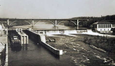
As I mentioned, our hotel in La Crosse was right beside the Mississippi, and ‘underneath’ the Big Blue Bridges (actually the Cass Street Bridge and the Cameron Avenue Bridge) that cross from the Minnesota side to Wisconsin.
That got me thinking. The population expansion across the USA in the 19th and 20th centuries involved crossing many rivers, and building many bridges. On the Mississippi alone there are at least 130 bridges along its length. In the Twin Cities alone there are nine major crossings and several minor ones. One of the most impressive is the Smith Avenue or High Level Bridge, from where there is a magnificent view of the St Paul skyline and the river.
The Smith Avenue bridge from the river.
As this video pans right, you can first see the magnificent Catholic cathedral, then the white Capitol building, followed by downtown St Paul.
Finally, on our last Thursday in St Paul, we took our grandchildren Callum and Zoë on a relaxing 90 minute river cruise up the Mississippi to the confluence of the Minnesota River with the Mississippi, which is a short distance downriver from where Hannah and Michael live. They tell us that the Fall cruises, when the autumn colors are at their height is a great time to cruise the river.
You can read about some of our other Mississippi adventures here.
Every year since 2010, Steph and I have visited our elder daughter Hannah and her family in St Paul, Minnesota, one half of the Twin Cities (with Minneapolis). We made our last visit in 2019, and then the Covid-19 pandemic struck.
Travel wasn’t possible in 2020 or 2021, but last year Hannah, Michael, Callum, and Zoë flew over to the UK to spend a couple of weeks with us in the northeast of England, just outside Newcastle upon Tyne.
Even though for most people the pandemic is over, and Covid is perhaps less of a risk right now, it’s still around, so Steph and I have continued to mask when we shop at the supermarket, in fact, in any situation where we could be in close proximity with others.
So it was with some slight trepidation that I went online at the end of January and booked flights to the Twin Cities with Delta, to depart from Newcastle International Airport (NCL) on 29 May, and returning from Minneapolis-St Paul (MSP) on 19 June. And with both schedules transiting through Schipol (AMS). Until Delta made a schedule change for us, and had us returning via Detroit (DTW) and AMS.
On 29 May, we had an early start to get to the airport for our 06:05 KLM952 flight (codeshare DL9627) to AMS. I’d booked a taxi with the local Blueline Taxis for 03:45, and about 15 minutes before it arrived I received, via the company’s mobile app, details of the taxi (make of vehicle, color, registration) and name and photo of the driver. NCL is only a few miles west of Newcastle city center, and just 11 miles from our home. At that time of the morning it took only 20 minutes or so for the journey.
For the past three months I have struggled with my mobility (due to a nerve issue in my lower back, legs and feet) and have to use a walking stick for added stability. However, that has certain advantages when there are long queues at check-in. We were invited to move to the front of the queue, using the business class lane.
That’s our KLM Boeing 737-800 (registration PH-BCK) at the terminal.
We had just under an hour to wait until boarding, when a very kind member of the cabin crew saw me attempting to climb the steps into the aircraft, carrying a light piece of hand luggage at the same time. She came down to meet me and took the bag to my seat.
And there we sat for the next hour, until 07:17. Why the delay?
There was a high pressure weather system over the UK that morning, giving clear and calm conditions at NCL. In the Netherlands at Schipol on the other hand, the airport was experiencing brisk northerly breezes, and had to change the landing runways. However, one of the two used for landing into northerly winds was under maintenance, and so our flight wasn’t given permission to leave NCL until a landing slot had been confirmed. Meanwhile, the attentive crew served drinks and snacks and kept everyone well-informed of flight connection details and any complications.
Fortunately we were not affected since we had more than two hours connecting time between flights. Arriving at Gate D28 (if my memory serves me right) at the far end of the pier, we had to make our way to D3 close to the main concourse. So, by the time we’d picked up some duty free and made our way slowly to our gate, flight DL161 was already boarding, and business class passengers called forward for the 10:40 departure.
Once again, Steph and I were directed to the front of the queue and once on board, settled ourselves into seats 30A and B in the Delta Comfort+ section of the economy cabin.
We’ve travelled in Comfort + several times now, and find that it’s definitely worth the extra premium you have to pay for that little bit of extra legroom that can make a long flight more bearable. Also our seats were against a bulkhead, making access to the aisle that little bit easier.
Our aircraft, an Airbus A330-300 (registration N801NW) had been in service for around 20 years, and was beginning to show its age somewhat. The flight pulled back from the gate 36 minutes late and the taxi at AMS to runway 36L took another 15 minutes. But we were soon on our way, arriving in MSP just over 8 hours later.
Here’s a video of that flight. I was unable to take any video of the flight from NCL to AMS. Seated in row 10, there was no window!
On our return to the UK on 19 June, flight DL2619 (an Airbus A320-212, registration N368NW) departed MSP at just after 09:00, arriving in DTW at 11:35 (taking into account the 1 hour time difference from CDT to EDT).
We had four hours to kill. The McNamara Terminal at DTW is enormous, 1 mile long. There is an express tram inside the terminal—just under the roof—travelling the length of terminal and connecting to the gates at various stops. In the video below, there’s a short clip of the tram.
The Airbus A350-900 (registration N503DN) on DL132 to AMS was a new aircraft for me, and I used Skymiles to upgrade to the Delta Premium Select cabin (seats 22H and J, aisle and window).
Premium Select cabin 2-4-2 configuration on the left (that’s Steph sitting in the third row), and the economy (3-3-3 configuration) on the right.
It’s a beautiful aircraft, and its enormous Rolls-Royce Trent WXB engines swiftly launched us on our way. I think you will be impressed with the take-off in the video. On landing in AMS, after a 7 hour flight, the pilot applied the brakes rather abruptly and you can hear all manner of glass and cutlery crashing to the floor (around 12’36”).
Route of DL132 from DTW-AMS on 19/20 June 2023
Our final 1 hour connection to NCL was a KLM Cityhopper-operated flight, KL953 (codeshare DL9689) on an Embraer E190 (registration PH-EZT).
Despite all the glorious weather in the UK over the three weeks we were away, the approach into NCL from the west was cloudy, and we saw very little of the glorious Northumberland landscape until we descended through the thick cloud layer.
So, after four years, what were our impressions and experience of flying once again? As with so much air travel, it’s not the flying per se, it’s navigating the airports. And having a mobility issue, I’ve come to realise how unfriendly so many airports can be in terms of accessibility. Too many stairs, or broken elevators or walkways!
Then there are the unannounced gate changes. On our arrival in AMS at 05:35 on 20 June (Gate E6), we had to walk towards the main concourse before we found a departure board, listing our NCL flight departing from E21, exactly in the opposite direction from which we had walked, and right at the end of the pier. It was a bus gate. But after an hour waiting patiently there, I noticed that the monitor was no longer showing our flight. But there was no further information nor announcement about a gate change.
After some enquiries I discovered that we had to go all the way back to D6, and although I asked for transport from a KLM representative, she told me it wasn’t anything to do with her, and we’d have make our own way to the gate.
Our flight from AMS to MSP was comfortable and smooth, in the main. I noticed that the safety announcements no longer referred to ‘turbulence’ but ‘rough air’. Perhaps ‘turbulence’ implies much more. Our return flight in the Premium Select seats was definitely more comfortable, with an extendable leg rest.
Overall, I felt that the service offered in Delta Comfort + had declined, and was essentially the same in Premium Select (which had a printed menu, steel cutlery, and a better amenity bag and headphones). The food was the same, served in compressed (and presumably recyclable) containers, but with wooden cutlery in Delta Comfort + that was hardly usable.
Served with ice cream from Northumberland!
I’m not sure I would actually pay the extra for a Premium Select seat, but as long as Steph and I have Skymiles to ‘spend’, then I reckon we might well upgrade again in the future.
Well, that’s how we flew to the USA and returned. You’ll find out what we got up to during our three week vacation in Minnesota in the other blog posts in this series.
Ernest who? Ernest Marples. Minister of Transport in the Harold Macmillan and Alec Douglas-Home Conservative governments between October 1959 and October 1964.
As Minister of Transport he introduced parking meters, the provisional driving licence, the MOT test, yellow parking lines, and traffic wardens. He also oversaw an expansion of the road network and the opening, in November 1959, of the first section (53½ miles) of the M1 motorway, between Luton and Crick (although it had been inaugurated a year earlier).
The M1 was not the country’s first motorway, however. That honor is given to an 8¼ mile section of the Preston by-pass, opened in November 1958, and which became part of the M6 motorway.
I remember the first time my father took us on the recently-opened first section of the M1. It must have been around 1960. What an experience on such wide carriageways, and very little traffic. That’s hardly the case today. More like Chris Rea’s The Road to Hell, released in 1989, supposedly about the London Orbital Motorway, the M25, although, to be fair, it could be about any of our motorways.
So much congestion, lines of juggernauts traveling nose-to-tail. I never relish having to take one of the motorways for my journeys, but they are a necessity. Many motorways were constructed with three lanes in each direction, but some like the M5 (opened in 1962 and connecting the West Midlands with the southwest of England) had only two for much of its length, but later widened to three.
From those humble beginnings more than 60 years ago, the motorway network in Great Britain (not including Northern Ireland) now extends over 2300 miles (out of a total of 247,500 total road miles). Another 29,500 miles are A roads, major routes connecting cities, but only about 18% are what we in the UK call dual carriageways (divided highways in the US).
Originally there was no speed limit on the motorways. In December 1965 a temporary speed limit of 70 mph was introduced and made permanent in 1967. That remains in force today on motorways and dual carriageways, with 60 mph the limit on other A and B roads. The limit in urban areas is generally 30 (maybe 20) mph.
But if you want to really explore the countryside, as Steph and I like to do, then you have to get off the main routes and take the B roads, as you can see in this video, which I made recently as we crossed Northumberland (in the northeast of England). In any case, for me it’s never about the trip itself but the many interesting places and sights along the way.
I passed my driving test (at the second attempt) in May 1966, six months after my 17th birthday, the earliest age when one can apply for a driving licence here in the UK. I got to drive my father’s car from time to time, but while away at university between 1967 and 1972 I didn’t have much opportunity to drive, until I had my own car (in October 1971), a rather battered Ford Anglia. In September 1972 I bought a new left-hand drive Volkswagen Variant to export to Peru, where I moved in January 1973.
Between 1973 and 1981 we lived in Peru and Costa Rica (in Central America), and from 1991 spent almost 19 years in the Philippines (from where we traveled to and down the east coast of Australia). We also made two road trips around Ireland in the 1990s while on home leave from the Philippines. Our road trip experiences were very different.
Since retiring in 2010, however, Steph and I have enjoyed several road trips around the UK. taking in Scotland in 2015, Northern Ireland in 2017, Cornwall in 2018, and Sussex and Kent in 2019.
And, since 2010, we have (until the Covid pandemic struck) visited the USA every year and made some epic road trips that are described briefly later on.
Touring Peru
A couple of months after I arrived in Peru, the ship carrying my Volkswagen finally docked at Callao, the port for Lima. It was just the right sort of vehicle for the rugged roads that Steph and I traveled exploring that fascinating country. Solid suspension (although I did add heavy-duty shock absorbers) and an air-cooled engine.
Almost five decades ago, there were few paved roads in Peru, the main one being the Panamerican Highway stretching the whole length of the country, just a single carriageway in each direction. And the Carretera Central from the coast to the central Andes at Huancayo, crossing the high pass at Ticlio on the way.
Most elsewhere, apart from in the towns and cities, the roads were unpaved. And through the Andes, these roads followed the contours of the valleys. Often you could see your destination in the valley below, but know there would be many kilometers to travel as the road snaked down the valley, as you can see in these photos.
Above Tarma on the road to San Ramon
Then there was the ever-present danger of landslides which might take hours if not days to clear, or precipitous drop-offs at the side of the road. I remember on one occasion driving along one road (in fog) in the north-central part of Peru, and afterwards checking the maps to discover that the drop was about 1000 m.
Three of the most interesting trips we made were to Arequipa and Puno on the shore of Lake Titicaca in the south of the country, to Cajamarca in the north, and to Ayacucho and the central Andes on another occasion.
In Costa Rica
Many of the roads in Costa Rica were paved when we lived there in the mid-70s, with some notorious exceptions. Turrialba, where we lived, lies 41 km due east from Cartago (San José lies a further 19 km beyond Cartago). From Turrialba to Cartago, there’s a climb of almost 800 m, passing through a cloud zone (zona de neblina) on a narrow and twisting road that was, back in the 1970s, unpaved for most part.
Further this was the main route from the Caribbean port of Limón on the east coast to San José, and was always busy with one juggernaut after another. Not to mention the tractors towing a dozen or more sugar cane carts along sections of the road, without any hazard lights whatsoever.
The Philippines
Mostly, the Philippines has good roads. It’s just the congestion and the lack of driver discipline that makes driving in that country stressful. Also, farmers drying their rice or maize harvest along one side of an already narrow road.
Drying maize along the highway in Nueva Ecija, north of Manila. The more numerous rice farmers do the same.
We lived in Los Baños, the Science City of the Philippines, location of the University of the Philippines-Los Baños, the Institute of Plant Breeding, a local office of PhilRice, as well as the headquarters of the International Rice Research Institute (IRRI) where I worked for almost 19 years.
Los Baños is sited along the shore of Laguna de Bay, and on the lower slopes of a dormant volcano, Mt Makiling. It’s almost 65 km south of Manila and, on a good day, a little under 90 minutes by road. Back in the day we used to joke that it took anywhere between 90 minutes and a lifetime to make the journey. Major road improvements took almost 15 years to complete and with traffic congestion (caused mainly by tricycles and jeepneys) the journey could take several hours. Here’s a short video of a trip to Tagaytay (a town that overlooks the Taal volcano), about 50 km west of Los Baños by the quickest route (map).
In 2009, my staff, Steph and I made a long-weekend trip to the world-famous rice terraces in the Ifugao-Mountain Province of northern Luzon. Staying in Banaue, we took a jeepney to the end of the trail leading to the Batad rice terraces.
From there we had to hike for well over an hour deep into the valley.
Steph and I would also spend about eight weekends a year on the coast at Anilao (map) where I scuba dived and she would snorkel.
When we first visited Arthur’s Place in March 1992, there was no passable road from Anilao to the resort, and we had to take a 30 minute outrigger or banca ride. By 2009, the road had been paved.
Touring the USA
I really enjoy driving in the USA, once I’d become familiar with a number of the driving norms and the various road signs. Our elder daughter lives in Minnesota so our trips have begun or ended there. Thank goodness for the interstate highways whose construction was begun under President Eisenhower in the 1950s. We prefer to follow the US or state highways mostly if we can, even county roads.
These are the trips we have taken:
2011 – the southwest states of Arizona and New Mexico, taking in the Grand Canyon, Monument Valley, Canyon de Chelly, among other wondrous sights.
2015 – since we had already traveled round Scotland earlier that year, we visited Chicago by train instead.
2016 – I’d broken my leg in January, so when we visited in September, we spent a few days seeking out the source of the mighty Mississippi in Minnesota.
And, along these travels, one thing that caught my attention. In the UK, road construction has involved the building of just a few major bridges, over river estuaries, the most recent being a second bridge crossing the Firth of Forth west of Edinburgh in Scotland.
Not so in the USA. East-west or north-south, immense bridges had to be constructed across the many rivers that criss-cross that vast country. Some of the most impressive have been along the Mississippi, Missouri, and Ohio Rivers.
Simon Kenton Memorial Bridge over the Ohio River at Aberdeen, OH connecting OH and KY on US62.
Champ Clark Bridge carrying US54 from IL to MO at Louisiana, MO.
Bridges over the Ohio and Mississippi Rivers at Fort Defiance State Park, connecting KY, IL and MO.
South Grand Island Bridge over the Niagara River, NY.
2020 was meant to be a positive year of change. In early January we placed our house in Bromsgrove, Worcestershire on the market, with the hope (expectation?) of a quick sale. Instead, it’s a year on hold.
By the end of 2019 we had already decided (after pondering this decision for a couple of years or more) to leave the Midlands and move north to the Newcastle upon Tyne area, to be closer to our younger daughter Philippa and her family: husband Andi, and sons Elvis (8) and Felix (6).
Steph and I are not getting any younger (70 and 71, respectively) and we decided that if we were going to make a move, we’d better get on with it while we had the enthusiasm, and continuing good health. Newcastle is almost 250 miles from where we currently live.
Back in January we thought we might be in Newcastle by mid-year, early autumn at the latest. That was before Covid-19 reared its ugly head. We are now in lockdown, and will be for the foreseeable future. Heaven knows when we might eventually push through with a sale.
So, with the expectation of this house move, we had already decided not to make our ‘annual’ visit to the USA (and road trip as in past years) to stay with our elder daughter Hannah and her family in Minnesota: husband Michael, Callum (9) and Zoë (7). Instead, they had decided to join us all in the Newcastle area for a two week vacation from early August. That’s also on hold until conditions improve and is unlikely now until 2021.
Since retirement in 2010, Steph and I have been making these US visits, and taking another holiday here in the UK, such as to Scotland in 2015, Northern Ireland in 2017, Cornwall in 2018, and East Sussex and Kent last year. As followers of this blog will know, Steph and I are avid members of both the National Trust and English Heritage. Alas, those day trips are also on hold.
Anyway, to cheer myself in the absence of any holiday breaks this year, I decided to look through the various blog posts I have published about many of the places we have visited in the USA—shown on the map below—and then give you my top five choices. As you can see from the map, there are several regions of the USA that we’ve not yet explored: Colorado, Utah and Idaho, southern Midwest, and southern states.
The dark red symbols indicate various national parks or other landscapes we have visited. Each has a link to the relevant blog post. The green symbols show cities where I have spent some days over the years.
It’s very hard to make a choice of my top five. But here they are, in no particular order (the links below open photo albums):
Having said that, Canyon de Chelly really is my No. 1, and I would return there tomorrow given half a chance. So why not include the Grand Canyon or Yellowstone in my top five? They would certainly be in the top 10.
We have been so fortunate to have had such great opportunities to travel around the USA. And we look forward to many more, filling in some of the gaps as we go.
I hope you enjoy looking at these road trip sites as much as we did visiting them over the past decade.
Following our epic drive in mid-June from Maine to Minnesota (after already having crossed Massachusetts, Vermont, and New Hampshire, and explored parts of western Maine for six days), Steph and I settled into a couple of weeks of relaxation with our elder daughter Hannah and family in St Paul, MN before heading back to the UK on 10 July.
My son-in-law, Michael, is – like me – a beer aficionado, and keeps a well-stocked cellar of many different beers. It’s wonderful to see how the beer culture has blossomed in the USA, no longer just Budweiser or Coors. I had opportunity to enjoy a variety of beers. Those IPAs are so good, if not a little hoppy sometimes. However, my 2018 favorite was a Czech-style pilsener, Dakota Soul from the Summit Brewing Company based in St Paul.
Relaxing in St Paul was also an opportunity catch up with some of my blogging, while Steph spent time in Hannah’s garden making sure everything was coping with the very hot weather. Notwithstanding the regular watering, we did experience a couple of quite spectacular downpours the like of which I haven’t seen for some time.
And our lively grandchildren, Callum (eight just two days ago) and Zoë (6) kept us on our toes. For one of the two weeks we stayed in St Paul, I was their summer camp chauffeur, dropping them off at the bus just after 8 am each day, and picking them up late in the afternoon. We were also ‘babysitters’ over six days and five nights. That’s the first time we’ve taken on this role; it was the first time that Hannah and Michael left the children with grandparents for more than just an overnight stay, while they celebrated their 40th birthdays with a visit to California’s Napa Valley.
Outcome? I think Callum and Zoë survived us – no permanent harm done!
There’s quite a lot of ambiguity associated with looking after someone else’s children – and they know it! Even though it was made clear to both that ‘Grandad and Grandma were in charge’, you’re often faced with situations asking yourself how Mum and Dad would react. Obviously we haven’t looked after small children for more than three decades since Hannah and Philippa were small. Although we had TV in the 1980s, there were no video games, or subscription channels like Netflix offering up a continuous menu of cartoons.
Both Hannah and Philippa had quite a large circle of friends within easy distance of home, some just a few doors away. So whenever the weather was fine – or even if it was not – one or the other would be round a friend’s house, or the friends at ours. It’s a sign of the times but ‘play dates’ have to be arranged for both Hannah’s and Philippa’s children. This is not only a reflection of busy lives for Mums and Dads, but also that no friends live next door.
We had fun with Callum and Zoë, although they might not perhaps reflect well on the occasions when I had to ‘lay down the law’. We went bike riding (they did the riding while we followed on foot), and explored the fascinating glacial potholes at the Interstate State Park 53 miles northeast from St Paul beside the St Croix River at Taylors Fall.
Afterwards we spent time at a splendid children’s playground at Stillwater. We ate out one night, went out for breakfast on the Sunday, and had a BBQ. Here are some more photos of that outing.
Grandma Mary (Michael’s mother) took the children to the Minnesota Zoo one day so Steph and I could enjoy a day at the Minnesota Landscape Arboretum (here are the 2018 photos), somewhere we have visited a couple of times in the past.
Beautiful echinaceas, a typical species of the prairies
And any visit to St Paul would not be complete without checking out the Marjorie McNeely Conservatory at Como Park (map).
We’ve been going there since 2006 when it was the venue for Hannah and Michael’s wedding. The floral displays change with the seasons, and we always enjoy seeing what the gardeners have prepared for their many visitors. This summer’s display was much more subdued compared to other years.
May 2006
December 2007
July 2016
June 2017
June 2018
I would certainly recommend a visit to Como Park if you’re ever in St Paul. There is also a small zoo and fun fair, very popular with the children.
The Mississippi River is just 50 m from Hannah’s front door, but at least 50 m below. There are some lovely walks and parks along the river, Hidden Falls Regional Park, about a mile from Hannah’s, being one of them. But the river was high this year, with flooding closing several of the walks nearby. The St Croix River at Stillwater was the highest we have ever experienced.
Beside the Mississippi at Hidden Falls Regional Park.
The St Croix River at Stillwater. That’s Wisconsin on the far (east) bank.
Finally, this commentary about relaxing in Minnesota would not be complete without mention of Hobbes, a lovely ginger rescue cat who has his moments, going from sweet and docile to full on attack mode at the drop of a feather. But over our time at Hannah and Michael’s he did begin to relax with us and, more often than not, this is how he spent much of his time.
Leaving Niagara Falls via the Niagara Scenic Parkway on the Sunday morning, we headed south, skirting Buffalo and the eastern shore of Lake Erie towards Pennsylvania, and the Allegheny National Forest. Our destination was Canton in Ohio, just south of Akron, a journey of 313 miles.
Along the Niagara Scenic Byway, there are two impressive bridges across the Niagara River on I-190.
There was little traffic around Buffalo, fortunately, even though it was a fine morning for Father’s Day. Soon enough we were outside the city limits and heading south into Pennsylvania.
Pennsylvania was a ‘new’ state for us (as were OH and IN), and I particularly wanted to travel through the Allegheny National Forest.
We travel on the interstates as little as possible, taking US highways and county roads in preference. You get to see a lot more of rural America that way. But roads are none too wide with few places to stop. And certainly no easy stops for photography. So on these two days we have little to show, photographic-wise, for our long days on the road.
The next morning we had an early start as we decided to cover the whole route that I’d planned, some 447 miles south through Ohio, crossing the Ohio River into Kentucky, before crossing the river again further west into Indiana to reach our next destination, Bloomington.
The drive through OH took us through some delightful towns and villages, and productive agricultural landscapes. Although we saw road signs to be aware of Amish buggies on the road, we only saw a couple.
Somerset is a small town about 110 miles south of Canton. In the middle of its impressive town square (which had a very English feel to it) there was a statue to a famous son of Somerset, Union General Phil Sheridan.
We also passed by Dover OH, home to infamous Confederate guerilla leader William Clarke Quantrill (I just bought a biography to read), and also Bainbridge, home to the first dental school in the USA, opened in 1825.
Eventually we reached the Ohio River at Aberdeen OH. The Ohio is a very impressive river and as I commented in a post after last year’s road trip, its flow is greater than the Mississippi. No wonder that rivers like the Ohio were used to open up the interior of the country.
This is the bridge that carries US68 into Kentucky. We crossed a little further west on the William H Harsha Bridge, carrying US62.
Aberdeen is also the terminus of Zane’s Trace, the first continuous road through Ohio, from 1798.
Crossing into northern Kentucky, we were less than 50 miles north of where we had driven through the state in 2017. Then it was over the Ohio again, and into southeast Indiana. Our good friend and former IRRI colleague Bill Hardy (a native born Hoosier) told us that we should see the southern part of the state, since the northern half was flat and rather uninteresting, maize upon mile of maize. He was right. The drive into Bloomington was delightful in the early evening sunshine, with Highway 46 weaving through the trees, up and down dale.
After a restful night in Bloomington (yet another Comfort Inn!) we set off the next day for the penultimate sector of our trip that would take us to Ludington on Lake Michigan in the state of that name. This was another long drive, over 400 miles, north to Gary IN, and then wending our way north along the eastern shore of the lake.
Just over the state line into Michigan we stopped to have a quick picnic lunch at a rest area (and Michigan information center) on I-94. We were very impressed with the amount of tourist literature and maps available at the information center; Michigan certainly knows how to sell itself.
Just north of the state line we took a short detour to Warren Dunes State Park. Lake Michigan is like a vast internal sea, and along its shores, certainly the eastern shore, there are huge sand dunes, now covered with mature woodland. The sand is extremely soft, and hard to walk across. Just like being at the seaside, and although the day was overcast, enough brave souls were enjoying beach to the maximum.
This is Tower Hill Dune that rises to more than 230 feet above Lake Michigan.
Warren Dunes State Park, MI
Then it was back on the road again, heading for our last night stop of the trip, at Ludington, before taking the ferry across Lake Michigan the next morning to Manitowoc on the Wisconsin shore.
The ferry, SS Badger, across Lake Michigan is operated by LMC – Lake Michigan Carferry. Badger is the last coal-fired ferry operating in the world.
It is 393 feet long, and has a beam of almost 60 feet. It was built in 1953 in Sturgeon Bay, WI. Its sister ship, Spartan, has been laid up in Ludington for many years. Originally the ferries carried rail cars.
The 60 mile crossing of the lake takes four hours, but you gain 1 hour moving from Eastern Standard Time to Central Time. As it was a Wednesday in mid-June, before the height of the tourist season, the boat was far from busy. The slow, easy-paced crossing was just my opportunity to catch up on some sleep, in readiness for the final push into the Twin Cities from Manitowoc across Wisconsin, some 321 miles.
We were at the dockside a little after 07:30, and they started to board the vehicles shortly afterwards for an on-time departure from Ludington at 09:00. Vehicles are driven on board by company staff. So before we sailed we had a good look around the vessel.
Soon enough we were headed out of Ludington harbor.
Leaving Ludington, MI to cross Lake Michigan to Manitowoc, WI
And before we knew it, Manitowoc was coming into view, and everyone was getting ready to disembark.
I had planned a route across Wisconsin that took us from Manitowoc through Stevens Point on US10. We took I-43 north for a couple of miles or so, then came off to take US10, only to see a sign stating that the road was closed some miles ahead. With that, I changed the settings on my satnav to take the quickest route to St Paul, rejoining I-43 around Green Bay, and west on Highway 29, until we joined I-94 west of Chippewa Falls for the final 75 miles into the Twin Cities. Highway 29 was a nightmare. Although a dual carriageway (a divided highway) it just went on and on, unrelentingly, in a straight line across Wisconsin. However, we did arrive to Hannah and Michael’s almost an hour earlier than anticipated.
Thus ended our 2018 road trip across twelve states: MA, VT, NH, ME, NY, PA, OH, KY, IN, MI, WI, and MN.
In nine days we covered 2741 miles, plus another 477 miles in Maine itself during the six days we stayed at the cabin. We used 133 gallons of gasoline, at a cost of $384 ($2.89/gallon, less than half of what we would have to pay in the UK for the same amount of fuel), at an average consumption of 24.19 mpg.
I’m already planning for 2019; Georgia to Texas through the southern states seems a distinct possibility.
St Paul, Minnesota is almost a second home. I’ve been visiting there regularly since 1998 when Hannah, our elder daughter, transferred from Swansea University in the UK to Macalester College, a private liberal arts college in St Paul. Incidentally, Macalester is the alma mater of former UN Secretary General Kofi Annan.
Hannah settled in St Paul after graduation, completed her graduate studies at the University of Minnesota, married Michael, and home is now complete with our two American grandchildren Callum (who will be seven in mid-August) and Zoë (five last May). So you see, Steph and I have many reasons for returning to the Twin Cities.
St Paul was the destination of our 2800 mile road trip from Georgia, beginning in Atlanta on 31 May and lasting 10 days, and covering 11 states. It was a great trip, but I was somewhat relieved when we pulled into Hannah’s driveway on the Friday afternoon, having covered the final 333 miles from Iowa City, looking forward to almost three weeks with the family and exploring favourite haunts, and hopefully discovering a few new ones. We are less familiar with the other half of the Twin Cities, Minneapolis (and currently in the news for all the wrong reasons), that lies on the opposite bank of the Mississippi from where Hannah and Michael’s home is in the Highland Park area of St Paul.
Callum finished the school year on the day we arrived, and Zoë didn’t complete her final childcare year at the St Paul Jewish Community Center until the following Wednesday. For the first three days of that first St Paul week we had Callum to ourselves, and both of them for the Thursday and Friday. So we had to find some fun things for Grandma and Grandad to do with them. The second week they went off to summer camp.
We visited Camp Butwin to check it out. Then the following Monday, it was Callum and Zoë’s first day. I was on drop-off and pickup duties!
Stillwater
Stillwater, a small town on the banks of the St Croix River (the state line between Minnesota and Wisconsin), some 27 miles east from Hannah’s home, is one of our favorite places. I first went there in 2004 with Hannah and Michael, and heard my first Lake Wobegon monologue from Garrison Keillor as we sat in the car park beside the river.
It’s a pleasant riverside town, that will become even better once the new bridge over the St Croix River is opened in August. This bridge will replace a narrow, 80 year old lift bridge in the town center.
This is the first time I have seen the bridge raised, to allow a paddleship through. The new bridge can be seen in the distance
The Lift Bridge at Stillwater
Being a main route over to Wisconsin, much heavy traffic currently passes through the town center; this should disappear after August. No doubt to the relief of Stillwater residents and presumably many businesses. But will the diversion away from the town center take away some passing trade? Probably not, as Stillwater has its own attractions for visitors.
Stillwater high street has numerous antique and souvenir shops, and bookshops. One gift shop, Art ‘n Soul, on the corner opposite the lift bridge, sells beads, mainly crystals. Every time we visit Stillwater, Steph (an avid beader) has to pop in just to check things out.
On the hillside above the town there is an excellent children’s play park, and Callum spent a very enjoyable hour amusing himself on all the apparatus.
The St Paul-Minneapolis Light Rail
Opened in June 2014, the Green Line of Metro Transit connects downtown St Paul with downtown Minneapolis, passing through the campus of the University of Minnesota. On a very cold June day in 2014, we queued up to take the first train from St Paul on the Green Line. Then the heavens opened, and we beat a hasty retreat to the car parked nearby. This was our first opportunity since then to ride the Light Rail.
Callum and Zoë couldn’t keep still, and I warned them about standing up while the train was moving. It travels at quite a lick, as the clip below shows, and the cross-city journey takes about 40 minutes.
On the return from Minneapolis (we’d met up with Hannah and Michael in downtown Minneapolis for lunch), and as we were approaching the Capitol/Rice St stop, there was an almighty bang, and the driver slammed on his brakes. We’d hit a car (with five passengers, including a baby) that had apparently tried to run a red light. Within minutes we were surrounded by police cars, rescue vehicles, the fire service, and ambulances. One woman was taken to hospital although did not appear to be seriously injured. For our part, Callum and Zoë happened to be sitting when the impact occurred. No-one was hurt on the train.
While St Paul exudes ‘old money’ and extravagant mansions along Summit Avenue, downtown Minneapolis is the bright and brash commercial center. Skyscrapers gleaming in the sunlight, reflections, and on one building, celebrating a local boy made good. Who? Nobel Laureate (for Literature) and sometime troubadour, Bob Dylan.
Local boy made good . . .
The McNeely Conservatory at Como Park
This is one of St Paul’s jewels. It is always a treat to see what delights the seasonal planting design brings. So, it is no surprise that we had to visit once again this year.
American Swedish Institute Midsummer, and we headed off to the American Swedish Institute, just off E 26th St in Minneapolis. It was a very hot Saturday, so we were glad to be able to tour the Turnblad Mansion, the focus of the institute today. Built by newspaperman Swan Turnblad at the turn of the 20th century. It’s ostentatious but so elegant, and a delight to view. I was fascinated by the Swedish ceramic stoves, known as a kakelugn, in many of the rooms. I didn’t have my Nikon with me, so the quality of the photos I took with a small Casio is less than I’d like. Nevertheless, they do give you an impression of this beautiful building.
Although I’d never been to the American Swedish Institute before, I was ‘familiar’ with the Turnblad Mansion, as I mentioned to one of the volunteers, John Nelson. The mansion featured in one of the programs by Tory politician-turned-TV presenter, Michael Portillo (he of the flamboyant trousers and jacket) about the Twin Cities, in his series Great American Railroad Journeys (a spin-off from his popular Great British Railway Journeys), and broadcast earlier this year on the BBC. I mentioned this to Mr Nelson, and he told me he had sat next to Portillo in the sequence where he dined at the mansion. He said he hadn’t seen the program nor met anyone, until that moment, who had!
The Minnesota Landscape Arboretum
This was our third visit to the arboretum. Again, we enjoyed a tour round the ‘Three Mile Drive’, discovering new landscapes where we didn’t stop last year, and renewing our acquaintance with those we had see previously only on the Autumn.
The St Paul waterfront
Finally, we took advantage of the excellent weather to explore the walks along the Mississippi close to where Hannah and Michael live, at Hidden Falls Regional Park, and beside the Downtown area of St Paul.
Finally, of course, we had time to sit back, relax and just enjoy being with Hannah and Michael and the grandchildren. And, of course, the addition to the family: Hobbes the cat!
All too soon our 2017 visit to the USA was over, and on 28 June we headed back to MSP to catch our overnight flight on Delta to AMS, with a connection to BHX. It’s three weeks today since we came home. It seems a lifetime ago. But there’s always next year!
It’s not even the longest river, as such, in North America. From its source at Lake Itasca in northern Minnesota (that we visited in 2016) until the Gulf of Mexico, the Mississippi is 2320 miles long.
The Missouri, on the other hand, which joins the Mississippi near St Louis, MO, flows eastwards for 2341 miles from its source high in the Rockies of western Montana before it reaches that confluence.
One of the other main tributaries of the Mississippi is the Ohio River, at a mere 981 miles, yet its flow is much greater than the Mississippi, and at its deepest point, near Louisville, KY, it is over 130 feet deep. That’s some river! The Mississippi and its tributaries drain almost half the land mass of the the United States.
The Ohio joins the Mississippi at the southernmost point of Illinois, Fort Defiance, just south of Cairo, an almost abandoned town that looks like it has suffered one flooding event too many over the years.
Cairo was, apparently, the prototype for Charles Dickens’ ‘City of Eden’ in his novel Martin Chuzzlewit (which I read recently as part of my 2017 Charles Dickens challenge) published serially between 1842 and 1844. Dickens visited the USA in 1842. He was not impressed with Cairo; neither were we.
We left Cave City, KY just before noon on the Wednesday (Day 8 of our road trip), heading to Troy, IL, and then to follow the Mississippi north through Missouri, Iowa, and southern Minnesota to St Paul. This is our route from Cave City to Iowa City.
Before reaching Fort Defiance, we had already crossed the Tennessee River, which joins the Ohio River near Paducah, KY. Just before Paducah, we turned west and reached the banks of the Mississippi at Wickliffe, just down river from the confluence.
There are two impressive bridges crossing the Ohio and Mississippi. Seeing the enormity of these constructions makes you really wonder at how much an obstacle these rivers were during the westward expansion of the settlers in the 18th and 19th centuries. Today the Mississippi alone boasts more than 130 bridges along its length.
The Cairo Ohio River bridge on the left (5863 feet) and the Cairo Mississippi River Bridge on the right (5175 feet)
Explorers Meriwether Lewis and William Clark camped here in 1803, and it was a strategic location during the Civil War, for obvious reasons commanding the approaches upriver to both the Ohio and Mississippi.
River selfies! We are standing at the tip of Fort Defiance, the southernmost tip of Illinois. Top: the Ohio River, with Kentucky on the far bank. Middle: the confluence of the the Ohio and Mississippi, looking south, with Kentucky on the left bank, and Missouri on the right. Bottom: the Mississippi River, with Missouri on the far bank over the Cairo Mississippi Road Bridge.
Leaving Fort Defiance, we headed north along the Mississippi, on IL3 until Red Bud, when we headed north and skirted around St Louis to the northeast to reach our next stop at Troy, IL.
The following day, the penultimate one of the trip, took us from Troy all the way north to Iowa City, mostly along the banks of the Mississippi. I can’t deny I faced the 43 miles from our hotel on I-270/70 around the north of St Louis with some trepidation. Although it wasn’t quite as busy as I had feared, there was some careful navigation and changing lanes constantly to ensure we headed out in the right direction. Eventually we reached our exit and headed north on MO79, having crossed the Mississippi to cross into Missouri, and then the Missouri River.
Just over 40 miles north from where we left I-70, the road ran parallel to the Mississippi, and just a few meters away. Having been on the road for a couple of hours, and looking for the inevitable comfort break, we stopped in the small community of Clarksville. There’s a lock and a dam at this point on the Mississippi, and just at that moment a large grain barge (probably empty) was moving through on its way north.
Clarksville has been flooded many times, and some of the riverside properties looked as though they wouldn’t be able to sustain yet another one.
At Louisiana, MO (about 36 miles north of Clarksville) we stopped to view the Champ Clark Bridge from a high vantage point. Built in 1928, this bridge no longer has the capacity for the traffic on US54. By the end of 2019 a new and wider bridge will be in place.
In southern Iowa, north of Montrose, we were reminded once again of the great migration westwards, of pioneers seeking a better life, in this case Mormons heading to Utah. In 1846, Mormons were hounded out of Illinois just across the river, at Nauvoo. The river is well over 1 mile wide here.
A bystander told us that the white building on the opposite bank in Illinois was a Mormon temple, now abandoned.
We turned inland at Muscatine, IA to spend our last night at Coralville, a suburb of Iowa City.
The following morning, we continued our route north across Iowa: flat, rather boring landscape, and mile upon mile of maize. Once we crossed into Minnesota, we turned northeast to Winona and the Mississippi once again. To the west of the town, there is access to Garvin Heights Lookout, some 500 feet above the river. What a view, north and south!
In this stretch of the river, it forms a series of wide lakes. North of Winona, we stopped briefly to view Lake Pepin.
Then it was time to push on, and complete the final 63 miles of our epic road trip via Red Wing and Hastings, MN. Leaving the Mississippi at Hastings and pushing westwards to wards St Paul, we finally arrived at the home of our elder daughter Hannah and her family alongside the Mississippi in the Highland area. The final three days were certainly a Mississippi adventure, although I never aspired to be a latter-day Huckleberry Finn.
The video below covers the final three days of our trip from Fort Defiance to the Twin Cities.
Yes. That’s right. Eleven states in just ten days.
2764 miles to be precise. Ninety-four gallons of gasoline consumed. Almost 30 mpg at just USD209. That’s not bad considering we rented a Jeep Patriot SUV (with a Connecticut licence plate!).
I’d opted for a car rental through Rentalcars.com and chose Alamo as the best deal. Just USD357 for the actual rental, USD250 for the one way drop-off fee, and USD98 for roadside assistance cover and various taxes.
I had planned our route meticulously, taking in various sites and landscape features I thought would be interesting, and avoiding as much as possible any of the interstate highways. I bought Rand McNally road maps for all states except Virginia and Minnesota (we already had a DeLorme Atlas & Gazetteer for MN). I checked precise US and State Routes using Google maps since the scale of the Rand McNally didn’t always show the road name. I even used Google Streetview to check the various intersections, and before we traveled I already had an image in my mind of the entire route.
I prepared daily detailed route plans on cards, which Steph used to navigate us across country from Atlanta to Minnesota, with each map marked at decision points corresponding to the route card details (you can just make out a series of circles on the map below).
Fortunately, US roads are very well signposted and road signs (e.g. US61 or GA23, for example) are posted every few miles. It was hard to go wrong, but we did on three occasions; nothing major, however. My first mistake was leaving the car rental center at Atlanta Hartsfield-Jackson International Airport. I turned on to I-85N instead of I-85S, but was able to turn around within a mile. On two other occasions we made a turn too early, but realised almost immediately. Not bad really for such a long road trip. Nor did we encounter any road works that held us up, or any road accidents. We almost never saw a police car.
These four map links show the actual route we took over the ten days:
We stayed in ‘chain’ hotels like Best Western, Comfort Inn, Quality Inn and the like, about USD100 or so a night. In Savannah we stayed at The Planters Inn on Reynolds Square, close to the river and other historic attractions, and this was our most expensive at around USD230 including taxes and valet parking. Breakfast (if you can call it that) was provided in each hotel. For lunch, eaten by the roadside or at a scenic viewpoint, we picked up a freshly-made sandwich and with some fruit from the hotel, we had enough to keep us going until a substantial dinner in the evening. Surprisingly, we ate Mexican on three nights and had very good meals. There was even beer! Twice we ate at the nearby Cracker Barrel Old Country Store – reasonable food but no beer. Walking into our second Cracker Barrel in Troy, IL it was déjà vu; the layout of the restaurant and the store was identical to the one we patronised in Johnson City, TN.
Anyway, here is a summary of our epic road trip.
31 May, Atlanta, GA – Macon, GA, 82 miles
Our flight (DL73) from Amsterdam landed on time just after 14:15, and despite arriving at an E pier and having to walk the considerable distance over to the new F International Terminal for immigration and customs, then taking a 15 minute shuttle to the new car rentals center beyond the airport perimeter, we were on the road not long after 16:00. We were headed to Macon on I-75, some 82 miles southeast of Atlanta towards Savannah to spend our first night, and recover—to the extent possible—from our long day of travel from Birmingham (BHX), arriving to our hotel (Best Western on Riverside Drive) just around 18:00
Just arrived at Best Western in Macon
We had the room on the right of the balcony, overlooking Reynolds Square
1 June, Macon – Savannah, GA, 167 miles
Since we had only a relatively short journey to reach Savannah, and because I wanted us to get a good rest before setting off once again, we didn’t leave Macon until after 09:00. Our hotel in Savannah (Planter’s Inn on Reynolds Square) had contacted me that morning by SMS asking what time we expected to arrive and hoping to have a room ready then. Not only was our room ready at just after 11:00, but we’d been upgraded to a balcony room. Once we had settled in, we set off on a leisurely stroll around the historic riverside where the old cotton warehouses have been converted to restaurants and other retail outlets, as well as apartments.
Savannah oozes history (and Spanish moss) – a direct line of historical events from the early 18th century, when it was founded, through Colonial times, and the turmoil of the Revolutionary and Civil Wars.
Savannah, GA
2 June, Savannah – Greenwood, SC, 196 miles We spent the morning in Savannah absorbing the Colonial, Revolutionary and Civil Wars history of this beautiful city. The weather didn’t look promising, with thunderstorms forecast, so we left the hotel by 07:30 and wandered through the various squares, parks and colonial streets for three hours, with just a small shower to bother us. After freshening up at the hotel and checking out, we were on the road again by 11:30, headed for Greenwood in the northwest of South Carolina.
The US17 route out of Savannah crosses the Savannah River over the fine-looking Talmadge Memorial Bridge, completed in 1991, 185 feet above the water.
We passed through a heavy rainstorm for the first 20 miles or so, but the weather brightened, and we stopped for a bite to eat beside the road in glorious sunshine. The road north was almost completely straight passing through small towns with names like Denmark, Sweden and Norway. There wasn’t much evidence of much agriculture, just some maize on this coastal plain with rather sandy soils. Communities seemed quite impoverished (according to the 2010 census it is the 7th poorest state). Nevertheless, the Southern Baptist (and some Presbyterian) churches and chapels stood in stark contrast. I’ve never seen so many places of worship so close together. There must be a lot of wicked souls need saving in South Carolina (and surrounding states) to require so many churches, often within just a few hundred yards of each other (or closer).
We were in Greenwood by 17:00, found our hotel, the Hampton Inn, and enjoyed steak and seafood meals at the Red Lobster outlet beside the hotel.
3 June, Greenwood – Blairsville, GA, 195 miles
Distance-wise this was never going to be one of the longest days, but I had planned our route climbing into the Appalachians through the Chatterhoochee National Forest on US60, a winding road among the trees.
We departed from Greenwood around 08:00 and made our first stop at the SC-GA state line to look over the Savannah River at Calhoun Falls. We had another stop at Cleveland, GA to tour the historic courthouse museum, and arrived in Blairsville by about 15:00.
Not wanting to go straight to our hotel, the Comfort Inn, so early in the day, we opted for a 55 mile round trip taking in some of the hills and forest to the north and east of Blairsville, arriving to Brasstown Bald, the highest point in Georgia at 4500 feet, around 16:30 just in time to take the last shuttle bus to the summit, and down again. I decided not to walk the 1 mile descent from the summit to the car park because the average gradient was more than 14%, and Steph and I were concerned that I might hurt my right leg, which is still giving me some grief 18 months after I broke it.
4 June, Blairsville – Johnson City, TN 282 miles
This was our opportunity of really traveling through the Appalachians. I’d chosen to travel east along the Cherohala Skyway in North Carolina. We had expected some poor weather this day, so set off as early as we could get away in order to enjoy the early morning brightness. The Cherohala offers some spectacular views along the way, and we were not disappointed at all.
Looking south from the Cherohala Skyway over North Carolina
But the further east we went, the more cloudy it became, and by the time we reached US441 to cross the Great Smoky Mountains National Park, it was raining quite hard and we didn’t really see very much at all. We took the side route of about seven miles to Clingman’s Dome, the highest point over 6600 feet. Couldn’t see a thing! But lower down on the north side, the weather improved and we did see something of the Smoky Mountains.
We then dropped down to Gatlinburg in Tennessee. If you’ve ever harbored the desire to visit Gatlinburg – don’t. What a tourist disaster! A narrow highway through the center of the town, tackiest tourist souvenir stores lining both sides, and even though this was early in the tourist season, there were throngs of people about. I’m glad we were only passing through. Then it was on to our hotel on the outskirts of Johnson City.
5 June, Johnson City – Charleston, WV, 380 miles
The focus early in the day was the Cumberland Gap, northwest of Johnson City by about 80 miles or so. Not long after leaving Johnson City, along US11, we passed through one of the heaviest rain storms I’ve ever experienced. I could hardly see in front of the car. But by the time we reached Cumberland Gap, the clouds had lifted somewhat, and the sun appeared.
The ‘Cumberland Gap’ is familiar to me from my skiffle days, as sung by Lonnie Donegan.
We went up to the Pinnacle Overlook, hoping to see the views over Tennessee, Virginia, and Kentucky – even as far as North Carolina on a good day. It was only a case of ‘now you see it, now you don’t’ as the clouds came rolling in, then dispersed. As a major pass through the Appalachians, the Cumberland Gap was strategically important for both the Union and Confederacy during the Civil War of the 1860s, and changed sides every so often. There is still evidence of military occupation high on the Overlook.
Looking north into Kentucky and the town of Middlesboro. The highway has just emerged from the tunnel through the Gap.
Then later in the day, heading east towards Charleston, the capital of West Virginia, we traveled along The Trail of the Lonesome Pine in Virginia. Until I was planning this trip, I wasn’t even aware that the Trail was a real entity, not after I’d heard Laurel and Hardy singing about it.
6 June, Charleston – Cave City, KY, 371 miles
Our destination this day was Cave City in central Kentucky where we planned to visit the Mammoth Cave National Park the following day. Heading west out of Charleston on I-64, we turned south at Morehead in Kentucky (about 110 miles west) to head south through the Daniel Boone National Forest.
We traveled some 125 miles along scenic highways and byways. Then we turned west on the Cumberland Parkway west of Somerset, KY for the rest of the day’s trip to make up some time and so as not to arrive to our hotel too late. However, Kentucky is divided into two time zones, so we gained an hour (from Eastern to Central Time) about 80 miles east of Cave City.
7 June, Cave City – Troy, IL, 367 miles
The Mammoth Cave National Park opened at 08:00, and we were at the Visitor Center not long afterwards. I had booked a tour of the Frozen Niagara cave some months back, at 09:20. This was a guided tour, the first of the day, and to a cave that was easily accessible. I didn’t want to contend with scrambling over rocks with my leg. In any case we planned to stay at the Park only until late morning as we still had the whole day’s trip of over 350 miles to make.
We enjoyed the cave, along with a group of fewer than 30 others. The caves are kept closed and it’s generally not possible to visit them alone. What amazed us is that the cave system, at over 440 mapped miles is the largest system in the world. The Park gets very busy during school holidays, and we were fortunate to have visited when we did.
Our next port of call was Fort Defiance at the confluence of the Ohio and Mississippi Rivers, and the southernmost point of Illinois. Most impressive.
That’s the Ohio River behind us and the bridge between Kentucky and Illinois . . .
At Fort Defiance, at the southernmost tip of Illinois, at the confluence of the Mississippi and Ohio Rivers
Then we followed the Mississippi north towards St Louis and our hotel in Troy just northeast of the city, catching a glimpse of the famous Gateway Arch as we skirted the city center on the Illinois side of the river.
8 June, Troy – Iowa City, IA, 332 miles
Our plan was to follow the Mississippi north through Missouri into Iowa. Heading west around the north of St Louis we crossed both the Mississippi and Missouri Rivers close to their confluence. Heading north on MO79, we stopped at Clarksville to stretch our legs, and look at the dam and lock, where a very large combination of barges was being ferried northwards slowly against the current.
Further north we stopped also at Louisiana, MO to view the Champ Clark Bridge that connects MO and IL, from a vantage point high above the river.
Then it was on to our next, and last, overnight stop in Iowa City.
9 June, Iowa City – St Paul, MN, 333 miles
Our last day on the road, heading north on very straight roads, before crossing into southern Minnesota and crossing the Bluff Country eastwards to reach Winona on the Mississippi.
Just south of the Iowa-Minnesota state line we passed through Cresco, IA which proudly advertises itself as the birthplace of Dr Norman Borlaug, father of the Green Revolution in wheat and Nobel Peace Prize Laureate in 1973, who I had the honour of meeting when I worked at IRRI.
In Winona, we took a short diversion to a scenic overlook about 500 feet above the river valley and had a spectacular view north and south.
Then we set off with added determination to arrive to Hannah and Michael’s in the Highland Park area of St Paul by late afternoon, and the end of our enjoyable 2017 road trip adventure.
Here are the individual blog posts about the various places we visited:
When I was a small boy, more than 60 years ago, I never saw any police officer on the streets carrying any sort of weapon, other than a sturdy truncheon. Regular use of firearms was unheard of in British policing, although I’m sure the police always had access to firearms if needed, provided the appropriate authorisation was given.
Sadly, it’s not uncommon now to see many police officers carrying side-arms, automatic weapons even. The increased threat of terrorist attack means that many public buildings, airports or railway stations are now patrolled by armed officers. And of course many police officers also carry a Taser to incapacitate dangerous suspects.
Of course it’s very different on the other side of the Atlantic. Firearms are regularly used by police and there has been a spate of incidents recently when police in several cities have shot African Americans following, it seems, minimal or no provocation. And, several mass shootings. Access to guns and the US Second Amendment has become a big issue in the presidential campaign. Did Donald Trump actually hint that Second Amendment supporters shoot his rival Hillary Clinton? Unbelievable!
Easy access to guns is something we are not just used to here in the UK. So, imagine my surprise recently during our mini-break in northern Minnesota, and stopped for coffee in the small town of Walker. Steph and I had gone into a coffee shop, and as we enjoyed our beverages, I leafed through several magazines and advertising brochures that were sitting on the table beside me.
Here were a couple of flyers advertising a million dollar gun sale at a local store, Reeds, that happened to be across the street from the coffee shop. Every type of weapon you can imagine was up for sale, and many other bizarre and obnoxious accessories as well. I couldn’t help myself. I just had to take a photo or two on my mobile.
We receive flyers and other advertising as inserts in free newspapers in the town where we live in England. But there are for furniture sales, new savings deals at one of the local supermarket, and the like. No guns!
Now northern Minnesota is hunting and fishing territory. But who needs an automatic rifle or worse for hunting? Who needs to go hunting in the first place, anyway?
So with my spirits rather dampened, we went for a walk up and down the street, and found a shop that specialised in beads and beading accessories – a major hobby of Steph’s. As she looked through all that was on display before choosing a range of beads, I had a look around the premises at all the tourist souvenirs. I couldn’t help taking photos of these two signs, and left the shop with a smile on my face.
Over the years we have got to know our way around St Paul, Minnesota, quite well. Minneapolis (the other half of the Twin Cities) less so. The grid system of tree-lined avenues and streets makes it quite easy to navigate around the city, with a significant number of avenues running west to east from the banks of the Mississippi River to the Cathedral Hill district.
Two avenues, Summit and Shelby, actually converge at Cathedral Hill (map), and from the steps of the magnificent Catholic Cathedral of St Paul, you can enjoy a panoramic view over the downtown area of St Paul, from the Minnesota Capitol (currently being renovated) to the northeast and the Mississippi to the southeast.
Looking east on Selby Ave towards the Cathedral of St Paul.
The downtown St Paul skyline, with the state capitol to the left, and the business district to the right. The Mississippi lies just beyond the business district.
So, a couple of weeks ago, Steph and I decided to drive over there, to take a walk round, and for me to do some photography. It has been six years since we last wandered round there. Our eldest grandchild, Callum, had been born just a month earlier in mid-August 2010, and while Hannah (our elder daughter, his mother) had a hair appointment, we pushed Callum around in his pram. Respite for the new mum, first grand-parenting responsibilities for Steph and me.
16 September past was a bright but overcast day, perfect for photography because there were no harsh shadows to complicate matters.
For the past seven years I have been using a Nikon D5000 DSLR. I bought it in the Philippines a few months before I retired, and I’ve been very happy with it. It had an 18-55 mm lens fitted when I bought the camera, and around 2012 I acquired a 200 mm lens. Now, while I liked that telephoto, it wasn’t very convenient having to constantly change lenses for just ‘that’ shot. Often, I just didn’t bother.
However, a few days before we flew to Minnesota for our latest visit at the beginning of September, I treated myself to an all-in-one lens, Nikon AF-S Nikkor 18-200 mm 1:3.5-5.6 GII ED lens – an early combined birthday and Christmas present. So our Summit-Selby wander was a good opportunity to test some of its capabilities.
I decided that some shots of the cathedral, both wide angle and telephoto from the same location would be quite interesting, and here are some of the results.
The Summit-Shelby neighbourhood is rather lovely, but expensive. Along Summit are some of the grandest houses that I have ever seen; and some more modest ones too. It’s also a neighbourhood famous for the great and good of St Paul who settled there over the past century or more. Authors F Scott Fitzgerald (The Great Gatsby) and Garrison Keillor (A Prairie Home Companion) both lived in the neighbourhood at one time or another.
In fact Keillor once owned a bookshop underneath Nina’s Coffee Cafe on the corner of Selby and Western Ave N, a well-known and popular meeting place in that neighbourhood (he has now moved to another venue on Snelling Ave near Macalester College).
These are just a few of the properties that caught my attention as we walked around.
And on the corner of Summit Ave and Western Ave N, there is a delightful small park, Cochran Park, with an elegant fountain with abronze statue of a running Native American with his dog at his feet.
All-in-all, an excellent morning’s exercise, coffee break, and photography. I look forward to many more opportunities.
During our visit to Minnesota in September 2015, we visited the Minnesota Landscape Arboretum (owned by the University of Minnesota) with Hannah and Michael, and grandchildren Callum and Zoë. Being a year younger than today, we had to get back home so they could have a post-lunch nap. So we really only had time to see the various gardens closest to the Oswald Visitor Center (click here for condensed visitor guide and map)
Steph and I returned to the Arboretum almost a month ago, and this year we took the Three Mile Drive around the site. There is so much to see, and the various plantings are laid out splendidly. The crab apple collection particularly caught my attention.
So rather than try to wax lyrical about the Arboretum, I’ll let you follow the links I’ve made here to the various websites, and let my photos speak for themselves.
We have been visiting Minnesota regularly for almost two decades, with the Twin Cities of Minneapolis and St Paul our main destination.
One geographical feature dominates the landscape in the Twin Cities: the mighty Mississippi. It bisects the metropolitan area, with Minneapolis on the west bank, and St Paul on the east. Since a decade ago, our elder daughter Hannah and her husband Michael have lived just a few blocks from the Mississippi. In April this year they moved to a new house along the banks of the river – although at least 50 m above the water, so no danger of flooding there as the river flows through a limestone gorge.
In this short video that I took on take-off from MSP last week, our Delta flight banked to the west, and followed the Mississippi northwest over the center of Minneapolis, and the rapids between the Central Ave SE bridge and that carrying I-35W.
Because of the ongoing rehabilitation from my leg injury earlier this year, I didn’t want to make a long road journey. But we decided to take a mini-break, just 3½ days (and a round-trip of 750 miles) to the source and headwaters of the Mississippi River north of the Twin Cities in northwest Minnesota.
What is the source of the Mississippi?
The source of the Mississippi was controversial for almost a hundred years in the 19th century, until, after a thorough hydrological survey by Jacob V Brower in 1888, Lake Itasca was confirmed as the source. Lake Itasca had been claimed as the source by Henry Rowe Schoolcraft in 1832.
Our first day itinerary, of about 260 miles took us northwest to Nevis, where we had booked bed and breakfast accommodation at The Park Street Inn, a house built in 1912 by banker Justin Halvorson who came to the town to set up a bank and devlop this region of Minnesota.
We spent almost the whole of our second day in Itasca State Park, touring the park by car, and stopping wherever the fancy took us. But our prime objective was the source of the Mississippi.
Our destination on the third day was Grand Rapids, no more than about 75 miles by the most direct route from Nevis. We took almost 200 miles! On the last day, Thursday, and with the weather deteriorating (there had been flash floods in the Twin Cities overnight) we headed back to St Paul by the most direct route.
Lake Itasca State Park
We entered the park at the south gate, and stopped at the Jacob V Brower Visitor Center to pay our USD5 park fee, and see the various exhibits about the park, its establishment in 1891, and the history of exploration of the Mississippi headwaters.
We took the road north along the lake to the source of the Mississippi as it leaves Lake Itasca, as a small stream bubbling over a small rapids, to begin its journey of more than 2000 miles to the Gulf of Mexico.
I would have liked to cross the Mississippi on foot, but didn’t dare even make an attempt, although I made it across a log bridge just 50 feet or so down from the rapids. And Steph only made it to the middle of the stepping stones. The gap between two stones was just too wide for her to feel comfortable and, in any case, one broken leg in the family was more than enough!
The Mississippi flows north out of the lake. Just a little further on, the park road crosses the river, no more than a stream ten feet wide, but with an auspicious sign alongside.
We followed the Wilderness Road right round the park, stopping every so often to admire the scenery, views of the lake, the Fall colours in the trees, and the old-growth red and white pines (the remaining stands of these in the state).
At the headwaters of the Mississippi there is an interesting set of displays about the river. This one caught my attention.
It’s interesting to note that the Mississippi is not the longest or largest (in terms of flow) of the rivers that drain the overall watershed. The Missouri is longer; the Ohio flows stronger. And other rivers, like the Arkansas, join the river further downstream. The Mississippi and its tributaries drain about half the United States!
Although we even made it to the Aiton Fire Tower (over half a mile on foot uphill from the nearest car park), and even though other visitors told us that there was a magnificent view of the forest from the top, at 100 feet high, that was too much for my head, and more than enough for my leg. We made it to just the fourth floor.
Our itinerary from Nevis to Grand Rapids took us via the small Schoolcraft State Park, named after Henry Rowe Schoolcraft. Here the Mississippi is already 50-100 feet wide.
Then the landscape drops noticeably into Grand Rapids where the Mississippi becomes a raging torrent and its power already harnessed by the building of a dam and creation of a lake to power paper mills.
Judy Garland – born in Minnesota, not Kansas!
Who’s from Minnesota?
Grand Rapids is the birthplace of Frances Ethel Gumm. Frances Ethel who?
Judy Garland to you and me, who was born here in 1922, but moved to California four years later. There was a museum a couple of blocks from our hotel. We passed it on our way south.
When I looked up information about Judy Garland, it crossed my mind to find out who else famous hails from Minnesota, or spent significant time there. I’d seen a sign to the ‘Charles Lindbergh homestead’ at Little Falls on the drive north where Lindbergh spent much of his childhood. Lindbergh was the first pilot to make a solo flight across the Atlantic in 1927.
Minnesota has quite a number of famous sons and daughters, including Hubert Humphrey and Walter Mondale (politicians), F Scott Fitzgerald and Garrison Keillor (writers), the one and only Prince (musician), and James Arness (actor, Gunsmoke), among many others.
We like Minnesota. The people are laid back, typical mid-West I’m told. The state has lots to offer, perhaps not as famous as attractions in many other states. Nevertheless, it suits us just fine, as it seems to suit Hannah and her family.
Steph and I enjoyed our 2016 visit to the Twin Cities in Minnesota. The weather was great, and since we had the daily use of a car, we could visit several places that are on our favourites list.
Among these was Como Park Zoo & Conservatory, that lies a couple of miles north of I-94 on Lexington Parkway in St Paul. We’ve visited Como Park for many years, especially its beautiful Marjorie McNeely Conservatory. In May 2006, our elder daughter Hannah married Michael in a lovely ceremony conducted in the Sunken Garden wing of the Conservatory where the most wonderful floral displays are planted throughout the year. We’ve visited in the Spring, mid-Summer, early Fall, and in the depths of Winter when we spent Christmas with Hannah and Michael in 2007. I placed a few photos from these visits in a story I posted last November.
On our recent visit three weeks ago to Como we were pleased to see that several changes had been made to the Conservatory since our last visit.
The planting was much more subtle this time, light pinks, blues and mauves in general. But always that sense that the gardeners had thought things through very carefully. And as you enter the Conservatory you are greeted by a heady atmosphere of the most beautifully scented blossoms.
Outside the Conservatory are the Ordway Gardens, a collection of bonsai specimens and a Japanese garden.
The Conservatory was built in 1915, and to celebrate its centennial a water garden was constructed outside the entrance to the visitor center. What a beautiful addition to a special place!
Having taken in all that the Conservatory had to offer, we had a very welcome cup of coffee in the visitor center, then headed off into the zoo. Many of the animals were taking a midday nap, but we did get to see the orangutans, giraffes, and flamingos.
So, if you ever find yourself in the Twin Cities, and have a few hours free—whatever the Minnesota weather—do visit Como Park and breathe in the botanical displays of the Marjorie McNeely Conservatory. You won’t be disappointed.
There’s water everywhere, notwithstanding all the lakes that characterise Minnesota. It’s not for nothing that Minnesota is known as ‘The Land of 10,000 Lakes’.
The Minneapolis-St Paul metro area (the Twin Cities) is surrounded (almost) by water. I’m talking about rivers. Large rivers.
The mighty Mississippi River bisects the cities. The Minnesota River is a southern boundary to Minneapolis. And the St Croix River is the state line between Minnesota and Wisconsin just east of St Paul, and its confluence with the Mississippi is just south of St Paul.
The Twin Cities (and surrounding areas) have their fair share of bridges – road and rail – that cross all of these rivers. There are twenty six highway bridges across the Mississippi, eight across the Minnesota River, and five across the St Croix (and another being constructed to relieve Stillwater of its congestion at the Lift Bridge.
Closest to where our daughter and her family live in the Highland Park neighbourhood of St Paul is the Mississippi River Bridge. Or should that be the Intercity Bridge, the Ford Parkway Bridge, or even the 46th Street Bridge? Its official name is ‘Intercity Bridge’, but at both ends there is a plate stating that the name is ‘Mississippi River Bridge’.
The Intercity Bridge, looking north from the Lock and Dam 1. Photo downloaded from the Minnesota Department of Transportation website.
Work began on this beautiful bridge in 1925, and it was completed two years later. It connected Minneapolis with the Ford Motor plant on the St Paul side of the river, now closed and demolished.
The following five photos were taken from an information booth above the old hydroelectric plant.
The Ford Motor plant is on the eastern side of the Intercity Bridge. Below the bridge is the hydroelectric plant that provided power for Ford.
Now that the trees have matured along the banks of the Mississippi, there are few clear views of the bridge from the banks, even from the viewpoints.
The next bridge upstream is the Marshall Avenue bridge, and can just be seen from the Intercity Bridge. Our daughter Hannah now lives just beyond the river bank treeline on the right of these photos, on Mississippi River Boulevard.
This is the view today of the hydroelectric power station, the dam and lock below the bridge.
About a mile further down river is Hidden Falls Regional Park. The road drops steeply down the bluff to the water’s edge. And there you get a real appreciation of the majesty and power of the flow of the Mississippi, even though it’s over 1200 miles to the ocean at the Gulf of Mexico.
Just over the Intercity Bridge on the Minneapolis side is Minnehaha Regional Park, and the beautiful Minnehaha Falls. On a visit to St Paul at Christmas 2007 we saw these Falls under very different circumstances: completely frozen. But not yesterday.
For one weekend last September, I almost felt like a ‘latter-day Johnny Appleseed‘. I hadn’t seen so many apples in a long time, nor been apple picking before. Seems it’s quite a family outing sort of thing in Minnesota, towards the end of September, and especially if the weather is fine—maybe an Indian Summer day even.
But I’m getting a little ahead of myself.
Steph and I flew to the USA on 10 September to spend almost three weeks with our daughter Hannah, son-in-law Michael, and grandchildren Callum and Zoë in St Paul, Minnesota. And we still can’t believe how lucky we were with the weather this vacation. Almost every day for the entirety of our stay (including a side trip to Chicago), the weather was bright and sunny, hot even with days often in the low 80sF.
The first weekend in St Paul, Hannah and Michael took us to the Minnesota Landscape Arboretum (part of the University of Minnesota), around 23 miles due east of Minneapolis-St Paul International Airport, along I-494 W and MN-5 W. There are miles and miles of roads and trails to explore, but with two small children of 5 and 3 in tow, we limited our visit to a walk through the various glades and gardens close to the arboretum’s Oswald Visitor Center (map).
The Perennial Garden (9)
Entrance to the Rose Garden (7)
The Herb Garden (4)
The Green Heron Pond
The Japanese Garden (7 on the map)
Hannah and Michael had taken Callum and Zoë to the arboretum on 4 July, when there was an impressive display of Lego sculptures around the gardens.
On the Sunday of our second weekend in St Paul, we met up with Hannah and Michael’s lovely friends, Katie and Chris and their daughters Nora and Annie, to go apple picking at a farm in the valley of the St Croix River (that joins the mighty Mississippi just five miles south), about 30 miles southeast from their home in the Highland district of St Paul. Thanks to Katie for several of the photos below.
Hannah and Michael with Katie (and Callum and Nora)
Michael and Hannah with Chris
The Whistling Well Farm offers several apple varieties for picking, as well as pumpkins and pot chrysanthemums for sale, and chickens to feed.
Chrysanthemums almost ready for sale.
It’s a great place for the children to explore, and to get thoroughly wet. There was a heavy dew!
Having ‘exhausted’ possibilities at Whistling Well Farms, we journeyed just a couple of miles west to Afton Apple Orchard, to take a trailer ride around the orchards and pumpkin fields.
What a lovely way to enjoy the company of family, especially grandchildren.
L to R: Hannah, Zoë, Michael, Callum, Steph and me.


 It’s by chance, I suppose, that Steph and I got together in the first place. We met at the University of Birmingham, where we studied for our MSc degrees in
  But fate stepped in I guess.


 While we were allowed to post marriage banns in the British Embassy, we had to announce our intention to marry in the official Peruvian government gazette, El Peruano, and one of the principal daily broadsheets (El Comercio if memory serves me right), and have the police visit us at our apartment to verify our address. I think we also had to have blood tests as well. This all took time, but everything was eventually in place for us to set the wedding date: 13 October.


 Steph became an enthusiastic beader and has made several hundred pieces of jewelry since then. In Los Baños we had a live-in helper, Lilia, and so in the heat of Los Baños, Steph was spared the drudgery of housework or cooking, and could focus on the hobbies she enjoyed, including a daily swim in the IRRI pool, and looking after her garden and orchids.


")


 There I gave a series of seminars on crop evolution and genetic conservation (focusing on potatoes) to staff of the agricultural research institute (IHAR). My hosts took me to the
 One of the best trips I made was to view the Matterhorn in Switzerland near Zermatt. I had a free weekend before I had to travel on to Rome, so I took the opportunity of a day excursion from Bern.


 Once again, Steph and I were directed to the front of the queue and once on board, settled ourselves into seats 30A and B in the Delta Comfort+ section of the economy cabin.


")


 2020 was meant to be a positive year of change. In early January we placed our house in Bromsgrove, Worcestershire on the market, with the hope (expectation?) of a quick sale. Instead, it’s a year on hold.
 My son-in-law, Michael, is – like me – a beer aficionado, and keeps a well-stocked cellar of many different beers. It’s wonderful to see how the beer culture has blossomed in the USA, no longer just Budweiser or Coors. I had opportunity to enjoy a variety of beers. Those IPAs are so good, if not a little hoppy sometimes. However, my 2018 favorite was a Czech-style pilsener,


 Just north of the state line we took a short detour to


 St Paul, Minnesota is almost a second home. I’ve been visiting there regularly since 1998 when Hannah, our elder daughter, transferred from Swansea University in the UK to


 Midsummer, and we headed off to the


 We have been visiting Minnesota regularly for almost two decades, with the Twin Cities of Minneapolis and St Paul our main destination.


 - Transferred from en.wikipedia(Original text : self-made), CC BY-SA 3.0, https://commons.wikimedia.org/w/index.php?curid=3732878")