The clues are there if you only know how to recognize them. For many landscapes it is quite difficult to determine just what forces of nature sculpted what we see all around us, and frankly take for granted as always having been there.
As a geography student at the University of Southampton in the late 1960s, I studied geomorphology (the study of landscapes and the forces that shape them) over three years. So it’s quite fun when we are out and about on our travels trying to work out how any particular landscape evolved. Of course, in the past 10,000 years or less humans have had a dramatic impact on what we see, often hiding the very features that would provide a straightforward answer.
But there are many landscapes when it is much clearer how ice, water, or wind acted upon the geology to reveal those landscape features that we all treasure. The tors of the Dartmoor, formed through chemical weathering of granite in a tropical environment, find their counterparts in Nigeria, for example.
Walking round Brimham Rocks in Yorkshire (just northwest of Knaresborough and Harrogate) the effects of wind erosion on a 400 million year old sandstone, Millstone Grit, during the last Ice Age some 12-18,000 years ago) – and earlier periods of weathering in warmer climates millions of years ago – can be clearly seen. And some fantastical rock formations are now carefully protected by the National Trust.
Steph and I visited Brimham Rocks at the end of September on our way north to Newcastle, and what glorious weather we had. You could see south and east 20 miles or more over the Vale of York. In fact the tower of York Minster was clearly visible on the horizon. And to the west, the landscape rises towards the backbone of England, The Pennines and the Yorkshire Dales.
At the beginning of September, we headed some 48 miles southwest of where we live in Worcestershire to Westbury Court Garden, a National Trust property in Gloucestershire, on the banks of the River Severn estuary. It was a typical early September day when high pressure dominates the weather scene – somewhat misty and murky, overcast, and the sun taking until mid-afternoon to burn away the worst of the low cloud.
Maynard Colchester commenced excavation of the garden in 1696, with the digging of the first canal, and layout of the garden in the formal Dutch style, shown in Johannes Kip’s 1712 engraving below of the house and garden. You have to remember that Dutchman William III was King at the time.
And until today, Westbury Court Garden remains the only surviving garden in this Anglo-Dutch style. There is no longer a house on the site.
There are impressive north-facing views over the garden and canals from the Tall Pavilion.
Along the canals are planted espaliered fruits, mainly heritage apple varieties (some dating back to the 1500s), but also some pears and plums. There is one area of formal gardens, but the gardeners are having to grub out the box hedges due to box blight. The yews lining the canals are apparently being affected by a fungal disease (a Phytophthora attack) and unless this can be brought under control the yew hedges might be lost as well.
The gardens are not large, but in the contrast between the canals (full – even choked – with water lilies) and the formal beds, they are a delight to the eye, and a haven of peace (even though a rather busy road does pass by at the north end). Among the features worthy of special mention are a glorious tulip tree (Liriodendron sp.) that must be at least 100 feet tall, and an impressive 400 year old evergreen oak (Quercus ilex).
Convolvulus tricolor ‘Royal Ensign’
Trumpet vine (Campsis radicans)
Tulip tree
Evergreen oak
You can easily take in all that Westbury Court Garden has to offer in 60-90 minutes, but as a stopover on the way to another destination (we were headed for the Forest of Dean, and The Kymin), it is certainly worth a visit. After all, it is a unique remnant of a by-gone era of gardening in this country before the fad for open landscapes (championed by the likes of Capability Brown) took hold later on in the eighteenth century.
It’s been a perfect picnic spot since Georgian times in the 18th century. And where’s this ideal place? Why, The Kymin, of course.
On a steep hill overlooking the town on Monmouth in the Wye valley on the English-Welsh border, The Kymin has a number of features that you wouldn’t associate with an inland site (although it’s not that far from the Severn Estuary).
There are two buildings at the top of the hill: the Round House (which is open only on certain days, and not when we visited) and the Naval Temple, constructed in 1800 to commemorate the British naval victory at the Battle of the Nile, but also British admirals who had played major roles in confronting the French leading up to that date.
The Round House
The Naval Temple
Admiral Lord Nelson and his mistress Emma, Lady Hamilton visited The Kymin in 1802.
On a clear day the views from the top must be spectacular to the south and west, towards the Brecon Beacons and the Welsh valleys. On the day we visited it had been overcast in the morning, and the cloud was beginning to burn away only by early afternoon when we arrived. But it was still very hazy and we couldn’t see many miles beyond Monmouth itself.
It’s a very narrow and winding road (but with passing places) from the main road A4136 up to The Kymin. But the climb is certainly worth the effort – if you can find the exit from the A4136 (traveling east to west towards Monmouth would be much easier, since the road leading up to The Kymin is on a sharp bend).
Clickety click? You play bingo, don’t you? It’s the 66 ball.
And yesterday was my 66th birthday. Another milestone. It has been a busy year, what with the 4th International Rice Congress in Bangkok three weeks ago (and the months of planning that went into that event).
But yesterday, I could indulge myself for a while. Our weather has been appalling recently – windy and wet, and getting colder. But yesterday dawned bright and sunny, so I took myself out for a 5 mile walk along the Worcester & Birmingham Canal. There were a couple of boats coming down the Tardebigge Flight (that’s 30 locks), and I got chatting with one of the boat owners. Seems they were traveling in tandem – two sisters and their husbands – since June! All over the country, and were now heading for winter quarters at Droitwich, just a few miles down the canal, for the next four months. They are live-aboard boat owners.
Then a little further up the towpath I stopped to chat with a surveyor from the Canal & River Trust who was checking out the brick and stonework in some of the locks. I discovered that this canal will celebrate its bicentenary next year. And thinking about that is really quite remarkable. Here was this canal being dug – by hand – over a period of 20 or more years, at the height of the Napoleonic Wars!
Anyway, it was a wonderful walk along the towpath, as usual.
And then in the evening, Steph cooked my favorite meal: steak and kidney pie, with a puff pastry crust (accompanied by potatoes, carrots and sprouts). Delicious! And, of course, the ‘mandatory’ bottle of wine, in this case a Rosemount Diamond Collection 2013 Shiraz – the perfect accompaniment to this delicious meal.
Definitely not! ‘Drifter’ implies someone wandering aimlessly about. That was not us. We knew where we were going. We just didn’t know what to expect while we were getting there.
So why is that? After our tour of Yellowstone and Grand Teton National Parks, we had planned to return westwards from Cody on the last day of our roadtrip and travel to Billings, MT for our last night before flying back to Minnesota. But since there were major roadworks via the north entrance to Yellowstone, we opted to turn east – and explore a part of Wyoming that we had not planned from the outset.
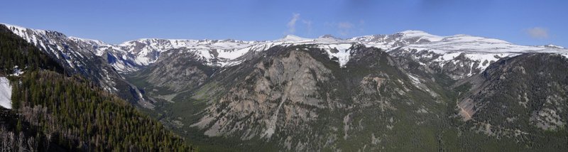
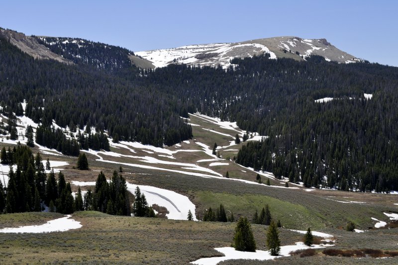
US14 was our route, taking us through Greybull, WY and up into the Bighorn Mountains. We’d been on the eastern side of those in Sheridan. And what a revelation the Bighorns were. We crossed the Bighorn Basin – which you can really only appreciate from high up on the mountains looking westwards, wound our way up through the canyon near Shell, over the Granite Pass (at 9033 ft), and on to a broad plateau, snow-covered in parts.
On the high plain east of Cody we came across a couple of interesting signs, one marking the Bridger Trail, a route to the goldfields of Montana during the 19th century – and surely a source of conflict with the Native Americans of the region – and the other explaining about the wild horses in the area.
What is so impressive about the Bighorn Mountains are the gradients to climb and which you have to descend. On our descent there was a 10% gradient for 10 miles! At the bottom we passed a cyclist – fully laden – who was just beginning the climb. I wonder if he ever made it?
Over the Bighorn Mountains
So although we never originally intended to make this detour, it proved to be an excellent way of spending our last full day in Wyoming and Montana. The sky stretched from horizon to horizon – Big Skies! And, for the most part, we had the roads to ourselves, such is the joy of motoring in the USA (something I really quite detest here in the UK because of the congestion that we encounter).
If you ever find yourselves in the vicinity of Yellowstone National Park, and you’re not sure whether to head east or west, you can’t go far wrong by taking a tour of the Bighorn Mountains. You won’t be disappointed.
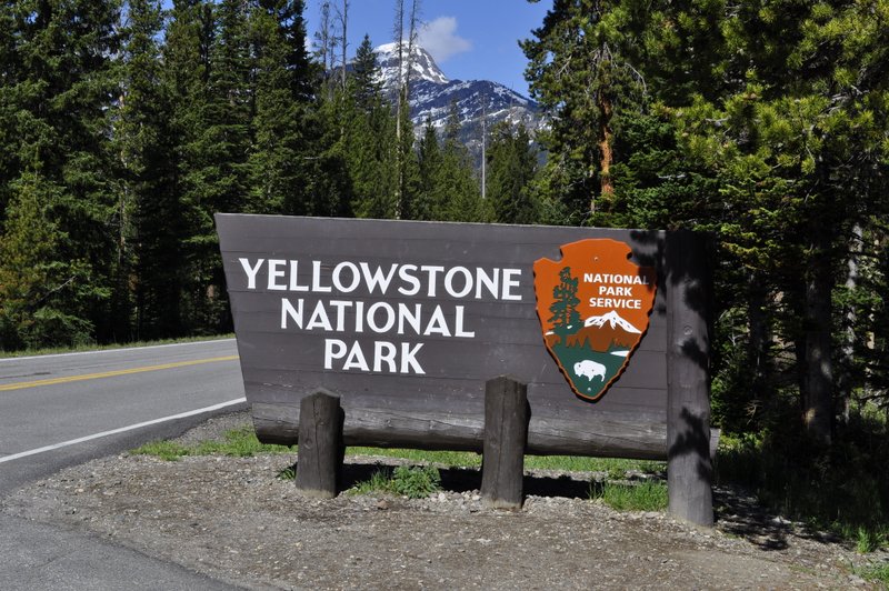
Yellowstone and Grand Teton National Parks in Wyoming were the planned destinations of our road trip last June across the Great Plains, although it didn’t quite work out that way. Including travel time through the parks, we originally planned to have three days exploring the various corners. In the end we stayed for just two. But this change to our itinerary was well worth it, as I explain in another post.
We entered Yellowstone through the northeast entrance, and had planned to depart through the north gate.
Northeast entrance to Yellowstone
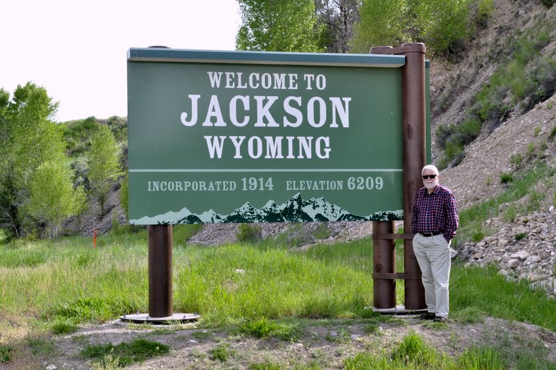
We also stayed at hotels well outside the parks – in Red Lodge (Montana), and Jackson and Cody (in Wyoming). Our scheduled third day in Yellowstone would have meant a long drive back west from Cody (about 70 miles) and then we faced a long journey north to get to our overnight stop in Billings from where we would fly back to St Paul. But there were major roadworks on this north exit road from Yellowstone and considerable traffic delays forecast. So we decided that rather than return to Yellowstone from Cody, we would head east and see what that landscape had to offer. But more of that another time.
As I have blogged elsewhere, Yellowstone was a little bit of a disappointment. Don’t get me wrong – the landscapes are truly magnificent, and the geothermal attractions all that I expected them to be. But there are quite long stretches of road that are almost completely closed in by forest on either side, and there’s not a lot to see. Fortunately we visited in early June so the tourist load was not that significant. I hate to think what Yellowstone must be like at the height of the summer. Nose-to-nose car bumpers I expect. And even in June we encountered several traffic jams as visitors hurriedly pulled off the road, whatever the prevailing condition, to catch a glimpse of a lonely elk or bison.
And the wildlife – or should I say the lack of it – was the other disappointment. I suppose my expectations had been raised through the many TV programs about Yellowstone that I watched over the years. Wall-wall wildlife? It was never going to happen. We did see a few small concentrations of bison (herds would be too strong a description) and a few elk dotted along the horizon. But that was it. although we frequently saw evidence that the wildlife was about and they visited the various geyser sites.
Nevertheless, we did enjoy our visit, and you can’t help yourself if the panoramas do sometimes take your breath away.
On our first day, we traveled through Yellowstone and Grand Teton from Red Lodge, MT to Jackson, WY following (for the first sector before we entered Yellowstone) the spectacular Beartooth Highway. We were fortunate that the road between Tower Falls and Canyon Village, just 19 miles, was already been open for the season, instead of a 51 mile journey via Mammoth and Norris. Click on the map below for an interactive version on the National Parks Service website.
And then we skirted west shore of Yellowstone Lake on our way south into Grand Teton National Park, and on to our accommodation in Jackson, WY.
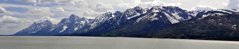
The following day, we headed north along the west bank of Jackson Lake in Grand Teton National Park and the base of the Teton Range, heading back into Yellowstone, where we took the west loop road from West Thumb to explore the Geyser Basin including the mandatory stop to watch Old Faithful put on ‘her’ display. On the way to Old Faithful we crossed the Continental Divide at least a couple of times, then headed north through Madison, on to Norris, back to Canyon Village and the east entrance skirting the north shore of Yellowstone Lake. What’s special about the Tetons is that they just rise out of the plain to more than 6,000 feet above (12,000 feet above sea level). It’s just like a wall of mountains aligned north-south. No wonder the Rockies were such an obstacle to cross for the early pioneers.
There’s so much out there on the Internet to read about both national parks that I’m not going to attempt to emulate or surpass those sources. Let me however, provide a small pictorial guide to our visit below.
Scenes in the north of Yellowstone from the northeast entrance
The Yellowstone River canyon
Sulphur Caldron
Yellowstone Lake
Old Faithful
Colors of the Geyser Basin
Hot springs in Yellowstone National Park, WY
Land of fire and brimstone
Landscapes of the northwest
Grand Teton National Park
The Grand Teton range
And finally, we left Yellowstone heading for Cody by crossing the Absaroka Range once again.
We also don’t regret our decision to find hotels outside Yellowstone. Within there park there is limited – and expensive – accommodation. Taking hotels in Red Lodge, Jackson and Cody ensured that we really did see as much of both parks in a limited time.
Well, that’s always going to be a matter of personal opinion. Beauty is, after all, in the eye of the beholder. I’m sure many would dispute this claim.
How about US101 on the West Coast for example, or iconic Route 66 (or what’s left of it)? Or some of the Fall Colors trails in the Appalachians or New England? Everyone will have their favorite neck of the woods and the roads that pass through. I have very limited experience of the eastern states – our travels have taken us mainly to the mid-West to visit family, and in the past four years we have chosen to head even further west for other vacation travels.
But I do agree that the Beartooth Highway (US212) between Red Lodge, Montana and the northeast entrance to Yellowstone National Park, and straddling the Montana-Wyoming state line, can surely claim to be up among the very best in the nation. It really is spectacular.
Last February, when we were planning our trip from St Paul, MN to Yellowstone, I laid out a broad itinerary I thought we could follow, taking in a number of iconic landscapes and attractions on the way: the Great Plains obviously, the Badlands, Mount Rushmore and the Black Hills in South Dakota, Devil’s Tower, Wyoming and the Little Bighorn battlefield, Montana, before arriving at Yellowstone itself. It was more or less by chance that we decided to enter Yellowstone through the northeast entrance via US212. And since we made the trip in early June, we were lucky that the road had just re-opened after its annual winter closure due to snow.
So what makes the Beartooth Highway so spectacular? From Red Lodge (which lies at an elevation of 5,568 ft) the highway begins to climb quite quickly, and not that far south of the town there is an impressive climb of seven miles of switchbacks to bring you to the summit at Beartooth Pass (10,947 ft). Now I had imagined that we would actually pass through the mountains, but instead the road goes right over the top, and that’s where the state line separating Montana and Wyoming lies.
The Beartooth Highway, MT
It’s a switchback down the other side, with magnificent panoramas over the Absaroka Range of the Rocky Mountains that skirt the northern edge of Yellowstone National Park. Landscapes to make your heart sing, and on the day we traveled the Highway, it was worthy of the Hallelujah Chorus from Handel’s Messiah or Hubert Parry’s Jerusalem!
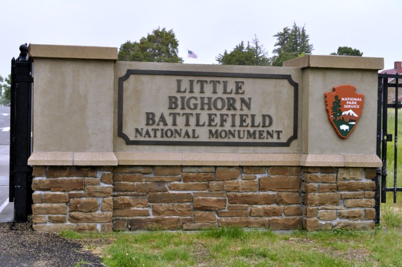
25 June 1876. Just a few days short of the first centennial of the United States. It took several days for the news to spread to the east coast. Lt. Col. George Armstrong Custer (Bvt. Major General) and many of his 7th Cavalry had been annihilated at the Battle of the Little Bighorn in Montana. George Custer – the ‘poster boy’ of the US Army, hero of the Civil War, renowned Indian fighter – defeated? How had this come about? Who should be the scapegoats, if any?
The Great Plains Indian Wars of the 1860s and 70s (and beyond) were, to a certain extent, a consequence of Custer’s own ego and sense of destiny. He had led an expedition into the Black Hills and discovered gold, which led to a massive influx of miners and settlers in contravention of the 1868 Treaty of Fort Laramie.
Up against Custer on that fateful June day were the combined forces of the Sioux nation – Lakota, Oglala, Minniconjou, and Hunkpapa, as well as Cheyenne, Blackfoot, Arapaho and other allies.
And chief among the Indian war leaders were Hunkpapa holy man, Sitting Bull, and Oglala war leader Crazy Horse (for whom there is no known image).
We visited the battlefield site on 6 June this year. We had set out from Sheridan further south in northeast Wyoming in driving rain, low clouds hugging to tops of the undulating hills that characterize the Great Plains in these parts. The day certainly did not promise much. But our expected route (I90) took us right past the battlefield, and being an aficionado of all things ‘western’, I included this in our itinerary when planning our vacation trip earlier in the year.
By the time we reached Garryowen, the site of Sitting Bull’s camp south of the battlefield, the rain had dropped in intensity, but it was still rather dank and dismal, and there was quite a breeze. Would the clouds ever lift so we could actually make an appreciation of this famous landscape?
Well luck was with us, mostly. For about half an hour the clouds did lift, and we were able to walk around Last Stand Hill, view the various memorials, and take in the harshness and emotive quality of this site. You can’t fail to be moved by all the markers – white for soldiers, brown for Indian warriors – that are dotted all over the battlefield site, but obviously with a concentration at Last Stand Hill.
A panorama of the battlefield site from Sitting Bull’s camp on the left (near present-day Garryowen) to Last Stand Hill on the right, marked by the memorial.
Little Bighorn battlefield, MT
Some years after the battle, the bodies of the soldiers were exhumed and placed together in a mass grave, over which was erected a plinth. The marker stones indicate where all combatants fell. There is even a horse cemetery.
For me however, and much more emotive is the fairly recently constructed Native American memorial. It is beautiful in its simplicity. After all, they died just for trying to defend their way of life. It’s therefore ironic that both Sitting Bull and Crazy Horse met ignominious deaths some years later not on the battlefield, but while essentially in ‘custody’ at the hands of their own peoples.
Since visiting the Little Bighorn I’ve read two books that have made quite an impression upon me, and certainly provide better balanced accounts of the Indian wars. I can recommend Stephen E. Ambrose’s Crazy Horse and Custer that was first published in 1975. And during my recent trip to the Philippines, I saw a copy of a book I knew of but had never read. As an indictment of the perfidy of the late 19th century United States government and its various agencies and Army, Bury My Heart at Wounded Knee by Dee Brown is a must-read for anyone interested in the history of the Indian Wars from a Native American perspective.
Another fascinating account, Nothing Like It in the World (also by Stephen Ambrose) describes the construction of the transcontinental railway beginning in the 1860s, and also contributing to the tensions and hostilities between US and Native American nations.
Crossing the Great Plains east to west, and west of the Badlands, you become aware of a dark line on the horizon. Is that an approaching storm? It could well be. But as you get closer you realize it’s an isolated range of hills, rising about 4,000 feet above the surrounding plains. These are the Black Hills of South Dakota, which have their maximum elevation in Harney Peak (7,244 feet). Sacred to many of the Native American tribes of the Great Plains – principal among which were the Sioux – their sanctity was violated when the 1868 Treaty of Fort Laramie (which had ‘supposedly guaranteed ownership of the Black Hills to the Lakota and other tribes) was broken following by the discovery of gold (ironically by General George Armstrong Custer). The United States government was unable (or incapable) of preventing the invasion of the Black Hills by miners. Conflict between the settlers and the Native Americans was inevitable.
For many – certainly on this side of the Atlantic – their first introduction to the Black Hills must have come from the 1953 movie Calamity Jane starring Doris Day in the title role and Howard Keel as Wild Bill Hickok. Certainly it was a highly sanitized (and fantasized) interpretation of events around that time. But who can forget this particular song? Released as a Doris Day solo, I certainly remember it very well from my childhood right through the 1950s.
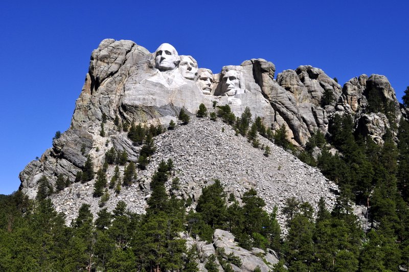
Mount Rushmore
We were heading for Rapid City and the Black Hills with one particular destination in mind: Mount Rushmore National Memorial. Under normal circumstances, I wouldn’t normally visit an attraction like Mount Rushmore. Like many others I’d seen my first images of this iconic location in Alfred Hitchcock’s North by Northwest. I guess I thought the whole experience would be rather kitschy – and my fears were not allayed as we drove from Rapid City to Keystone in the heart of the Black Hills, and on to Mount Rushmore, just a mile or so beyond. Either side of the highway were various tourist attractions that I would never visit in a month of Sundays. Just not to my taste.
But how wrong I was about Mount Rushmore. In fact it was almost an emotional experience. The day was superb; hardly a cloud in the sky, and we joined several thousand more tourists (many from Asia) to marvel at the wonder of the Mount Rushmore National Memorial and how the faces of four famous presidents Washington (#1), Jefferson (#3), Roosevelt (#26), and Lincoln (#16) came to be carved into the side of a mountain. And why these four presidents were chosen from all the possible candidates. Although I guess the contributions of some presidents to the development and well-being of the United States are best forgotten.
There is so much more written about Mount Rushmore in the link provided above – and more than I can eloquently draft; other details are provided by the National Park Service.
I was overwhelmed by Mount Rushmore – no doubt the beautiful day helped. But I was also inspired, not only about the people who had the foresight to create this national memorial, but also that the choice of these four presidents encapsulates the history of their diverse nation. So let me tell some of my Mount Rushmore story through the images I captured that June day.
Before the work began . . .
Mount Rushmore, SD
Four presidents in the sky
The Black Hills and Custer State Park
Traveling south from Mount Rushmore, and passing through several tunnels just wide enough for a SUV but no bigger, there is an opportunity of experiencing the beauty of the Black Hills – and appreciate why Native Americans held this place to be so special. In Custer State Park there is a healthy herd of about 1,300 bison, some of which we came across. A hugely damaging fire in 1990 opened up much rangeland, but even so, there is a bison round-up each September to manage the herd, and sell several hundred animals and keep the herd at a level which the park can sustain.
Taking a roundabout route back to Rapid City, we enjoyed the Needles Highway between Custer State Park and Hill City, and traveling north, we then took the back highway Sheridan Lake Road into Rapid City for our second night there. We didn’t visit the half-finished Crazy Horse Memorial, however. It was rather out of our way, but also it seemed to me to be a rather more exploitative and touristic attraction. There’s actually no known image/photo of Crazy Horse – one of the most important Indian leaders who played a pivotal role in the defeat of General Custer at the Battle of the Little Bighorn in June 1876, and who perhaps deserves a more fitting memorial in any case.
It was a Tuesday morning, early June. We’d reached Chamberlain, South Dakota on the banks of the Missouri River the evening before, having traveled down from St Paul, MN in glorious sunshine. To the west, however, there was an ominous glower in the sky that was already beginning to darken by breakfast-time. Checking the Weather Channel we learned to expect some thunderstorms as we crossed the Great Plains towards our next destination: the Badlands.
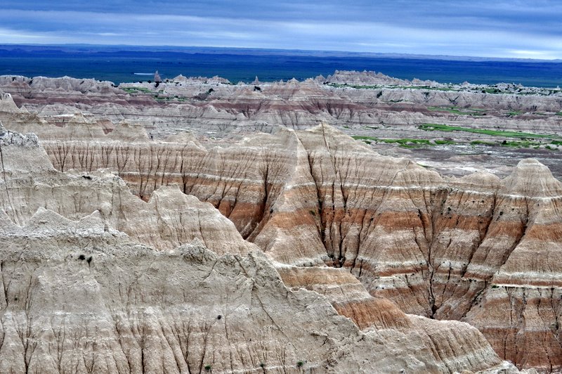
Stormy weather? That was that half of it. At one point it was raining so heavily I had to pull off the highway (I90) at one of the designated viewpoints. Not that we could see anything. However, after about 30 minutes we were able to continue our journey, and later found out that we had skirted the northern edge of a major storm tracking across the plains from west to east, accompanied in some places by baseball size hailstones. Luckily we missed those, and by the time we reached the Badlands National Park, the storm had passed, the skies brightened (a little) and we were able to enjoy the Badlands formations in all their glory.
Having now traveled across the Great Plains for several hundreds of miles, my respect has increased enormously for the early pioneers who crossed these open spaces in the 19th century on their way to the west coast, in California and Oregon, to make a better life for themselves. Not only did they have to combat the natural obstacles of the landscape – the plains, the Rockies, and the Sierra Nevada – but also hostility from the native Americans whose land they were crossing. When the era of the building of the transcontinental railway began in the 1860s, tensions and hostilities multiplied, but by the 1890s the various native American tribes had been defeated (massacred in many instances), moved to reservations, and their nomadic way of life (along with the vast herds of bison) had disappeared for ever.
Surrounding the Badlands is the Buffalo Gap National Grassland, and one can imagine what the Great Plains must have looked like in their original pristine state. There are also some important Indian reservations to which various tribes were banished in the last quarter of the 19th century – Wounded Knee is quite close by as well, where the infamous massacre took place in December 1890.
Leaving I90, you turn south to reach the Badlands National Park Northeast Entrance, passing by Minuteman Missile National Historic Site – which we didn’t bother to visit. We were much more interested in beautiful landforms, that echoed our visited in 2011 to Arizona’s Painted Desert (although it is much warmer there). The winds really blow on the Great Plains.
In the park we took the main Loop Road, but then continued on the Sage Creek Road for about 5 miles before turning north and rejoining I90 at Wall.
All the main viewpoints (‘overlooks’) are well sign-posted, the views spectacular, and on the day we visited, the contrast between the landscapes and the sky gave us some pretty dramatic images to cherish. Stretches of grassland are home to a herd of bison, and you are left wondering what these areas must have looked like in the mid-19th century when these magnificent beasts could be counted in their millions.
It gets windy on the Great Plains
The Badlands
The Badlands, SD
All in all, South Dakota’s Badlands are worthy of anyone’s time – they are truly magnificent.
I posted my first story about our USA vacation, across the Great Plains to Yellowstone National Park, at the end of June. A lot of things have generally kept me away from my blog over the past couple of months, but once my commitments to the 4th International Rice Congress are completed by the beginning of November, then I’ll be able to turn my attention full-time to this personal blog.
I’ve decided not to write the account of our trip in chronological order. Each day was different, with new sights to see, places to explore.
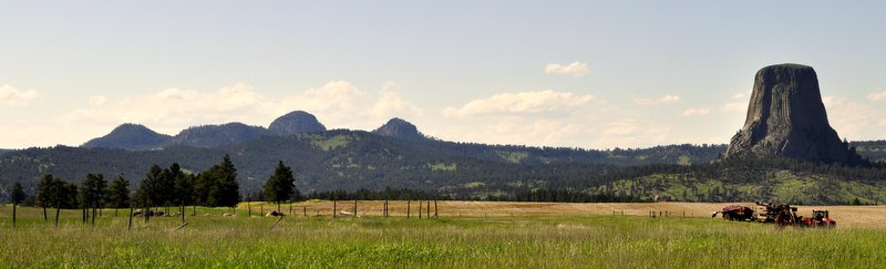
On Day 4, we left the beauty of South Dakota’s Black Hills and headed north through Spearfish Canyon into southeast Wyoming. Our destination? Devil’s Tower, that iconic volcanic plug immortalized in Steven Spielberg’s 1977 movie Close Encounters of the Third Kind.
While our vacation route followed I90 more or less the whole way, we could make diversions from that artery to explore various places that took our fancy. When I was planning our trip way back at the beginning of the year, I discovered that Devil’s Tower, in northeast Wyoming, was a relatively short diversion (in USA road travel terms) north of I90.
Heading west and cresting a low hill on the undulating plains, there was Devil’s Tower dominating the landscape on the distant horizon. It’s certainly a feature that you can’t mistake for anything else. And as we approached it just seemed to rise up in majesty from the surrounding countryside. This was our first glimpse of the rock, and we pulled into a viewpoint lay-by to have a picnic lunch.
Being a bright sunny day, with hardly a cloud in the sky, Devil’s Tower was quite busy as one might expect, but not as busy as it was likely to become later on in the season once the school-age children were on vacation. Parking, right at the base of the Tower, was easy and plentiful, and it was just a short 100-200 m walk from there to the Tower itself. And somewhat extraordinarily, this is as far as most visitors reached. Steph and me like to get our money’s worth, and decided to circumnavigate Devil’s Tower on the Tower Trail, a walk of about 1½ miles.
Once we were only about 100 m round the south side of the rock, there were hardly no visitors, and we had the place to ourselves. Peace and silence, generally. Just the tweeting of birds in the bushes, and calls of falcons soaring along the sides of the rock itself.
The first national monument in the USA
Devil’s Tower is sacred to many Native American tribes, and visitors are requested to respect any artifacts that might have been placed there. In 1906, Devil’s Tower became the first national monument, proclaimed by President Theodore Roosevelt.
I guess we must have left Devil’s Tower around 16:30 after about three hours. Distances can be so deceptive on a road map, and I anticipated it would take about 15 minutes to travel to I90. In fact it was nearer 40 miles. And then when we did reach I90 we discovered that Sheridan (our base for that night) was a further 127 miles! No matter. I put the Kia into cruise mode, and off we headed through some rather bleak terrain (it reminded me of the Pennines in the UK), and one of the world’s largest coalfields near Gillette, WY. But as we descended towards Sheridan, there to the west were the Bighorn Mountains which, at that time, we had not figured on visiting. We changed our itinerary later in the trip, as you can read soon in another post.
I began this post last night while waiting for my Emirates flight to Dubai in the Pacific Club Lounge in Terminal 3 at Manila’s Ninoy Aquino International Airport. I am now in Dubai waiting for my onward connection to Birmingham.
Until last Friday, 15 August, when they transferred to Terminal 3, Emirates along with almost all other airlines serving Manila still operated from the rather run down Terminal 1. That terminal is at last undergoing a much needed refurbishment.
While looking bright and clean, Terminal 3 is rather stark. But the check-in, immigration and security is a big improvement over Terminal 1. Maybe because so few airlines are yet relocated here. KLM, Cathay, and Singapore Airlines are due to join Emirates soon.
I settled myself into the lounge then decided to take a few photos. The lounge is nothing to write home about, adequate being perhaps the kindest description, but far superior to the lounge that Emirates used to use in Terminal 1.
Leaving the lounge to take some shots of the concourses, I hesitated over the threshold of the lounge entrance, and then the double glass doors suddenly closed on me. Rather than retracting, they continued to close. And all of a sudden there was a loud explosion as one of the glass doors disintegrated all around me, glass flying everywhere, and I was left standing in a pile of glass shards. No real damage to me, but the door was a mess. I have a small cut on my right leg, a nick really, now covered in a handsome gauze dressing. The lounge staff were most solicitous for my welfare. That first G&T on the flight to Dubai to recover from the ‘trauma’ hit the right spot.
For the past week I have been at the headquarters of the International Rice Research Institute (IRRI) in Los Baños in the Philippines, where I worked for almost 19 years until my retirement in April 2010. I had to attend two meetings in preparation for the 4th International Rice Congress (IRC2014) that will be held at the end of October in Bangkok, Thailand. The first meeting, from Monday to Wednesday, was the SciCom Exec to finalize the content and structure of the scientific conference. The IRC2014 Organizing Committee met on Thursday and Friday. We were kept busy from morning to night, although there were opportunities for some social gatherings, and I also took full advantage of staying in IRRI’s Guesthouse to enjoy the nearby swimming pool every morning at 6 am.
But I’m getting ahead of myself. My journey began on Friday 8 August, traveling on Emirates Airlines from Birmingham to Manila via Dubai (BHX-DXB-MNL). There were minimal delays at BHX, and we landed more or less on time in DXB around midnight local time.
Enjoying my first (?) G & T
My starter for ten . . .
The stopover was about three hours, and by the time I’d cleared security, checked out Duty Free, and made my way to the EK lounge in Terminal 3, there wasn’t too long to wait before we were boarding the next flight to Manila. That wasn’t a good flight. It was comfortable enough, but there was turbulence the whole flight – not severe by any stretch of the imagination, except for the occasional sharp bump – and just persistent enough to prevent me from settling. Added to that, a large gentleman across the aisle from me settled to sleep immediately after take-off from DXB, and snored the whole way to Manila! After landing in Manila NAIA Terminal 1, I had passed through immigration and customs in less than 20 minutes, but traffic congestion around the airport (it was around 5:15 pm on Saturday), and during the 65 km drive to Los Baños, delayed our arrival at the Guesthouse until almost 8 pm.
Meeting old friends
Despite the busy schedule of meetings, I was able to catch up with the many old friends at IRRI. I was given an office in my former DPPC unit, now called DRPC.
On Tuesday night I was treated to dinner at Sulyap Gallery Café and Restaurant in San Pablo, about 10 km south of Los Baños. And we had a lovely evening: great company, great food. What more can you ask for?
L to R: Eric, Zeny, me, Vel, Corints and Yeyet
On Wednesday, Yeyet and her husband Christian took me out to dinner in Los Baños. They were married in March, and had invited me to be one of their sponsors or ninong. Of course I wasn’t able to travel then, but I did send a short video message that was played during the wedding reception. It was a complete surprise to everyone (except Vel with whom I’d made the arrangements to receive and show the video).
On Thursday and Friday nights the IRC2014 committees got together to relax.
Checking out the genebank
Our meetings finished by Friday lunchtime, so I took advantage of some ‘free’ time in the afternoon to visit the International Rice Genebank in the TT Chang Genetic Resources Center, and meet my former staff and colleagues.
Now the genebank is really the only place in Los Baños where you can chill out. The Active Collection is kept around 2-3C, but the Base Collection is maintained at a decidedly frosty -18C. Since I left IRRI in 2010, a new and much larger cold room to house the Base Collection was added to the genebank infrastructure, with funding from the World Bank. Seeds are still stored in vacuum-sealed aluminium cans, but nowadays, everything is neatly bar-coded. (I was even shown a new tablet-based scoring system, complete with photos and descriptions, for germplasm characterization).
Pola, Ato, and Soccie – the ‘Three Musketeers’
Mel – handling seeds in the seed drying room, maintained at 15C and 15% RH
Ruaraidh Sackville Hamilton and Ato posing patiently in the Base Collection at -18C while I took my photos
Vacuum-sealed aluminum cans in the Base Collection.
Despite the fact that I had responsibility for the genebank for a decade from 1991, and obviously it’s my ‘baby’, I’m immensely proud of the staff and their conscientious attitude in conserving this extremely important germplasm collection.
Out and about on the farm – Typhoon Glenda
This morning (Sunday) I decided to take a tour of the IRRI Experiment Station, not only to see all the various rice breeding plots and experiments, but to visit the wild species screenhouses on the Upland Farm, and see what damage the recent Typhoon Glenda had caused.
‘You can take the man out of IRRI, but you can’t take IRRI out of the man’. Wandering around the farm, looking at all the fields and labs where I worked for almost 19 years it was hard not to feel really nostalgic. But when I visited IRRI last November, it was almost 4 years then since I had retired and I had been away long enough to have made ‘the separation’. Nevertheless, IRRI and its work has become part of my DNA, and I really do get a thrill wandering through the fields. Rice breeding and science is a numbers game, and IRRI plays that game to the highest proficiency. The field plots are immaculate, and surprisingly so considering the severity of Typhoon Glenda which apparently hung around the Los Baños area for more than 6 hours. There must have been some extremely turbulent vortices to have caused the damage that it did, although this time, there was little if no rain damage. Typhoon Glenda was a ‘dry’ typhoon compared to many.
Damage to the south side of Chandler Hall
The roof of the Service Building was ripped off
This quite new greenhouse, used in the C4 project, received severe damage
Many of the greenhouses received some damage to the roof and side panels
Many of the famous pili trees along Pili Drive from UPLB to IRRI were uprooted
Me and some of the GRC field staff inside one of the wild species screenhouses
Multiplying wild rices
Inside the wild rices screenhouse – some plants in the foreground are flowering
Soccie keeps this wild rice nursery in fantastic shape
Submergence tolerant rice varieties, showing variants with the SUB1 gene after a period of flooding – these are the green plants
IRRI is now using bar coding in the field for all its breeding lines
INGER demonstration plots – the variation between varieties is striking
Rice-maize rotation field plots
Demonstration plots of IR varieties, with iconic Mt Makiling in the distance
An Iranian feast
On Sunday evening, I met up with an old friend and former staff member, Bita, who now works for Accenture in Manila. Bita is originally from Iran, but moved to the Philippines when she was eleven. Both her parents are rice scientists. So Bita grew up in Los Baños, went to UPLB, married and had four lovely children, and has now opened an authentic Iranian restaurant in Los Baños called Everyday Kabab.
I had a lovely meal of dips and naan bread (check out Bita’s garlic and yoghurt dip) followed by chicken and beef kababs, prepared using Bita’s secret recipe. She also serves a traditional cherry drink from Iran; it’s neither sweet nor sour, but very refreshing. And Everyday Kabab is growing in popularity among the LB community – it certainly began to fill up while I was there.
And finally, another surprise . . .
Once we’d finished early on Friday afternoon and I left GRC, I returned to the Guesthouse for some rest, and to work in a more comfortable location. At least I could wear shorts and a T-shirt. But I hadn’t been in my room much more than 30 minutes when the phone rang, and to my surprise, it was Lilia Tolibas, our helper who worked for us for 18 years. Although working mostly in Manila these days, Lilia still has family ties in Los Baños, and had heard I was in town. And she came specially to see me.
We had a good chat for almost an hour, and it was then I heard about her misfortune during last November’s Typhoon Yolanda that hit her home town of Tacloban so badly. After we had left, she built a small house in Tacloban and moved many of her belongings there. But the tidal wave that hit the town destroyed her house, and sadly one of her sisters drowned. She works for the American Chamber of Commerce in Manila and they were quickly offering humanitarian relief. They found her family, and quickly also found her sister’s body who was given a decent burial, a dignity not afforded to so many victims. Lilia is still waiting for her compensation from the government from the humanitarian relief that so many countries donated. It’s a scandal that this is not being released to the victims and families.
Flying home . . .
Tomorrow night, Monday, my EK flight to DXB departs at 23:55 from the ‘new’ Terminal 3 at NAIA. I say ‘new’ advisedly since it was constructed almost a decade ago but, until now, had not be used by the major airlines. Emirates transferred to Terminal 3 last Friday. Let’s hope that this NAIA experience is far superior to many I’ve had out of the decrepit Terminal 1. I should be home in the UK by early afternoon on Tuesday.
A busy week, yes. Fruitful? Yes. Many things accomplished? Yes. Now it’s time to complete the final tasks and before we know it we’ll all be heading off to the congress in Bangkok at the end of October.
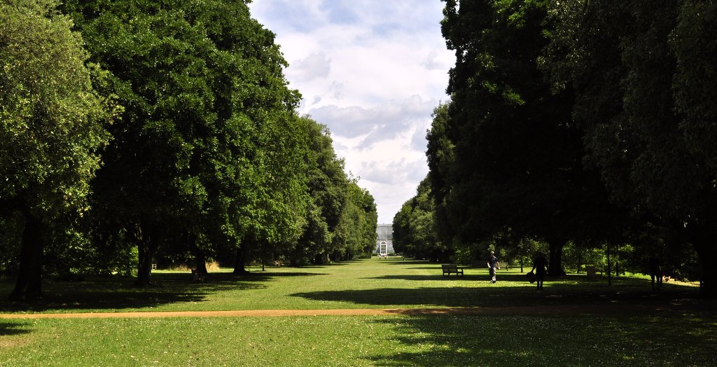
The day dawned fair, and as so often this summer, Steph and I took full advantage of the weather last Wednesday to take in yet another National Trust property. Heading 73 miles southeast from our home just south of Birmingham, our destination was Waddesdon Manor, built by Baron Ferdinand de Rothschild in 1874. Surrounded by mature parkland (these house builders from previous centuries certainly had a long term vision) full of majestic trees, Waddesdon Manor sits on a hill with magnificent views over the Vale of Aylesbury, the Chilterns, and west towards Oxford and the Thames Valley.
Designed in the style of a Renaissance French chateau, the property comprises the main house (with its separate ‘bachelor’ wing), overlooking an impressive parterre that the National Trust gardeners maintain to an impressive standard, a rococo aviary stocked with many species from Southeast Asia that we are familiar with from our nineteen years in the Philippines and, at some little distance from the main house, a stable block that now houses visiting exhibitions and dining outlets.
The North Front and main entrance
Waddesdon Manor, home of the Rothschilds
The entrance drive from the first floor
The South Front
Looking across the Parterre and Fountain Pool
The Parterre from the first floor
A fine example of the many flower beds, statuary and garden furniture found all around the Waddesdon park
The aviary
The stables
The National Trust has recently built a car park for 1000 cars, which goes to show just how popular visits to Waddesdon can be. We were quite lucky, and it was not too busy during our visit. There’s a regular shuttle every 10 minutes from the car park to the house. The walk takes a suggested 15 minutes (but we think much longer). Entry to the house is by timed ticket that can be booked online ahead of your visit.
There’s no doubt that Waddesdon Manor is one of the most impressive houses we have visited. Everything has been cared for, and the house certainly does not have the feel of a museum, even though it’s stacked to the rafters with the most exquisite objets d’art – but more of that later. Even as early as the last years of the 19th century Baron Ferdinand’s sister Alice was aware of the effect of sunlight on the furnishings, and from then till now, the house contents have been shielded in good part from the worst effects of light. Surprisingly, photography is permitted throughout the house (unless indicated otherwise, but there were no restrictions during our visit), but as with all National Trust properties, the use of a flash is not permitted. Thank goodness for the advanced settings on digital cameras that permit photography even in low light levels.
But it’s the interiors of Waddesdon Manor that leave one feeling rather slack-jawed. The opulence – and ostentation – is overpowering. Priceless clocks, ceramics, silverware, and sculpture adorn almost every available surface. Old Masters cover the walls. There is magnificent furniture dating back several centuries in almost every room. This is a Rothschild expression of wealth and power, kept in the family by a series of astute marriages between quite close relatives.
Paneling in the breakfast room, off the West Gallery
The Conservatory, off the Breakfast Room
Anteroom between the Conservatory and the Dining Room
The Dining Room
The Red Drawing Room
The ceiling of the Red Drawing Room
The Grey Drawing Room
An urn, 1m tall, in solid malachite, was a gift from the Tsar of Russia,
The Billiards Room in the bachelor wing
While you can’t help marveling at the wonder and beauty of the enormous collection assembled by Baron Ferdinand, I came away from Waddesdon Manor with a sense of unease. I have now visited quite a few National Trust properties over the past three years, many of them built and furnished by individuals who, in their time, were fabulously wealthy. Was Baron Ferdinand de Rothschild any different, or is it that the construction and furnishing of Waddesdon Manor is comparatively recent compared to many of the other properties? I read that Baron Ferdinand built Waddesdon to house his collection of fine objets d’art, to show off to his friends. So I got the feeling that he somehow assembled such a fantastic collection just because he could, not because he really appreciated their beauty. They were there to be displayed, not to add to the aesthetics of the Manor. Certainly there is so much to see, so much to take in, that it really is challenging to appreciate everything there.
Waddesdon was bequeathed to the National Trust in 1957, but the family still have an interest in the property. And one of these is the sale of fine wines from the Rothschild vineyards in the Bordeaux region of France. A visit to the wine cellars under the west wing is fascinating, with one of the galleries stretching for many tens of meters, and stacked, floor to ceiling, with boxes of wine ready for sale.
So although I’m glad I visited Waddesdon, and did marvel at the beauty of the many things we saw, it won’t be high on my list for a second visit any time soon.
And, it seems, that Lancelot ‘Capability’ Brown in one of his earliest commissions helped to realize the vision of the 6th Earl of Coventry to create Croome Court and Park, a neo-Palladian mansion in deepest Worcestershire, less than 10 miles southeast of Worcester, and 20 miles from our home in Bromsgrove in the north of the county.
Capability Brown
The 6th Earl of Coventry
Work started on Croome in 1751 and over more than a decade work continued to replace an earlier building on the site. But even as late as the 1790s changes were being made to the park.
While Brown was involved in the design of the hall itself, and of course his signature landscape design, many of the interiors of the hall were designed by equally famous neoclassical architect and interior designer Robert Adam who, with his rival James Wyatt, also designed many of the features – temples and the like – that are dotted about the park, and even follies some distance from the park itself, such as Dunstall Castle to the south and Pirton Tower to the north. The 1¾ mile lake, the Croome River, took 12 years alone to dig out by hand.
From the park there are good views of the Malvern Hills due west, and Bredon Hill, an outlier of the Cotswolds, further southeast. These aristocrats certainly knew just where to build a fancy residence!
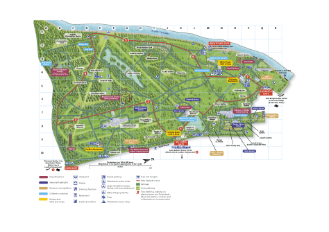
From the Visitor Centre (1 on the map, and once the sick quarters of nearby WWII airfield, RAF Defford), the footpath through a bluebell wood to Croome Park brings you out onto a hillside beside the Church of St Mary Magdalene (5), and impressive views out over the park and house.
And from that vantage point, there are long walks available in all directions throughout the park and beyond and lots of features to explore as shown in the map below and the subsequent photos.
5. Church of St Mary Magdalene An earlier church once stood here, but it was replaced by Capability Brown with this rather plain one, but with some impressive tombs inside.
7. Ice House Many country houses have an ice house – the National Trust has carefully restored this one.
29. Evergreen Shrubbery
27. Temple Greenhouse Designed by Robert Adam, there are fine views across the park to the main house itself. Glass windows have now been added.
26. Druid This statue was designed by James Wyatt, and after very careful scrutiny, we did discover the hidden date stamp – 1793!
25. Dry Arch Bridge The carriage drive built by Brown passes over the top, and here is also a detail of one of the facing stones.
22. The Grotto and Sabrina You can see the statue of Sabrina reclining on the left hand side of the Grotto, which is itself constructed from tufa.
23. Worcester Gates
28. Statue of Pan
21. Island Pavilion This is an elegant pavilion, which has undergone extensive restoration particularly to remove decades if not centuries of graffiti from the inside walls. The plaque on the rear wall shows a wedding scene.
15. Croome Court This building is both plain and elegant. From the rear, north side, it does appear very attractive at. But the South Portico, with reclining sphinxes either side of the elegant steps up to the door, is something else instead. Although the exterior design is attributed to Capability Brown, Robert Adam was responsible for some of the interiors, particularly the long gallery. The plaster work throughout has been extensively restored as part of the National Trust’s more than £5 million scheme. Only the ground floor and part of the cellars is currently open to visitors. We first visited Croome in March 2011. Three years later one of the rather dilapidated side wings has now had its roof and windows replaced and is on track for a complete restoration. Some other buildings at Croome were converted years ago into private apartments.
When we visited Croome in 2015, the house was encased in scaffolding and swathed in polythene, now removed. We have toured the house just once, in 2011. Work continues with the refurbishment inside, but because Croome was rather busy two days ago, we just enjoyed our walk around the park. I think a visit nearer Christmas might be appropriate to see how the house has changed over the past six years or so.
13. Rotunda This building lies about 150 m to the east of the south portico where the land rises away from the main park and Croome River. It has an impressive ceiling and other moldings.
16. Chinese Bridge (and Croome River) It’s hard to imagine the number of laborers it took to dig this ‘river’ if it took 12 years. There are footpaths all round the lake, where you can mix with the local livestock, and various water birds: coots, mallard, great-crested grebe, and Canada and grey lag geese (on the most recent visit).
17. Park Seat This sited on a high point looking north over the park towards the house. You can imagine what it must have been like in its heyday – a stroll or ride through the park, perhaps a picnic at the Park Seat. Elegance!
18. Carriage Splash
This is the view along the Croome River from the Carriage Splash.
9. London Arch
This is an impressive entrance to Croome on the east of the property, but now provides access, via a private road, to apartments that have been developed in some of the outbuildings of the house.
Croome Court has seen some changes during its history. George III visited, as did Queen Victoria and George V. It’s reported to have housed the Dutch royal family in exile during WWII. The Coventry family sold the house in 1948. It subsequently became a Catholic school, and even owned by the Hare Krishna sect. Today, while the garden and park are owned by the National Trust, the house itself is owned by the Croome Heritage Trust and leased to the National Trust.
So if you want to enjoy some culture and the opportunity for a brisk and bracing walk, Croome Court and Park is the place to visit. The photos in this post were all taken along the Park Seat Walk (in yellow on the map below, around 3½ miles).
Beyond the park, and towards the west and the Malvern Hills, stands the Panorama Tower (B on the map).
Celebrate Croome for its inherent, natural beauty.
Celebrate Capability Brown, who could realise the vision of his patron, and made an impact on English landscapes like no other before or since.
And celebrate the 6th Earl of Coventry, who had a vision, and the financial resources to do something about it.
Before Monday I’d never heard of Hailes Abbey. Owned by the National Trust, but managed by English Heritage, Hailes Abbey (or what now remains of it), is a 13th century Cistercian monastery, nestling under the Cotswolds escarpment, a few miles east of Tewksbury in Gloucestershire.
Having seen that the weather would be fine this week, we began to plan another day out. on Tuesday. Browsing through the Trust’s handbook for members it soon became clear that several properties we wanted to visit were not open on a Tuesday. That’s when I turned to a neat National Trust app on my new iPad mini. And that’s when I ‘discovered’ Hailes Abbey (and also a 14th century tithe barn in a village we would pass on our way home).
Royal connections Founded in 1246 by Richard, Duke of Cornwall, son of King John, and younger brother of Henry III, I was surprised to learn that Hailes had been an important house in the network of Cistercian monasteries founded all over England, and certainly one to rival Fountains Abbey or Rievaulx Abbey, although perhaps not quite on the same scale.
But that’s actually quite hard to fathom, since so little of the original buildings remain, that were constructed from the local oolitic limestone. It is clear however that, from the dimensions of the church at Hailes, it must have been a pretty impressive community, like many others that were founded more or less around the same time. Of course, Hailes suffered the same fate as other religious houses under Henry VIII’s dissolution of the monasteries in the early 16th century.
The monks gained much of their income from wool – supposedly they kept up to 4,000 sheep (the famous Cotswolds breed, perhaps). Also, the community had a relic of the ‘True Blood of Christ’ (and later on even a relic of ‘The True Cross’). Pilgrims apparently flocked to Hailes, and made donations for the privilege of venerating the relics.
Just a few walls are still standing today, and some of the surviving stone carvings have been removed to a small museum on site. Nevertheless, the dimensions of many of the buildings and rooms are still visible. And from the dimensions of the walls, and from what is still visible, it’s not too hard to imagine a grand church vaulting skywards.
Hailes Abbey, a 13th century Cistercian abbey
The surviving walls of the cloister
View of the church nave, looking to the east
The chevet – a series of radiating polygonal chapels
Looking west down the nave
On most days it would be an extremely peaceful site to visit, and in most respects it was. But the staff were busy mowing the grass, so for much of our visit there was the background drone of mowers and strimmers.
Just across the road from the Abbey is a small chapel, older than the abbey, and constructed in the mid-12th century, with some impressive frescoes still visible. I guess many churches were decorated like this before the Reformation. And behind the chapel is the site of a former castle, but no signs of it at all are visible today. Instead the fields are owned by a plant breeding company, and laid out to wheat variety trials.
Floor tiles below the altar, possibly taken from the abbey after the Dissolution
The twelve apostles
St Catherine of Alexandria, patron saint of teachers and philosophers
A hunting scene above the chapel door
Another medieval tithe barn
In August last year, we visited a tithe barn in Bredon. Just a few miles upstream, at Middle Littleton (just northeast of Evesham and south of Bidford-on-Avon), is another 13th century tithe barn. It’s certainly an impressive structure, and although we were there for only about 30 minutes, it’s worth stopping by. The stone roof is particularly interesting, especially seeing how the roofers accommodated changes in pitch and angle. The beam structure underneath holding it up is also impressive. It’s open every day from 2-5 pm, between 1 April and 31 October.
Although the weather yesterday wasn’t as bright as had been forecast a few days previously, we thought we would miss any showers that came along, so decided to push ahead with our visit to Attingham Park, a late 18th century mansion just southeast of Shrewsbury. And apart from one short shower, the weather did behave.
Built in 1785 for the 1st Lord Berwick, Noel Hill, politician and supporter of William Pitt the Younger, Attingham Park replaced an earlier house, Tern Hall. It had a chequered history, and the estate today (at around 3500 acres) is half the size it was at the beginning of the 19th century. The Berwick title became extinct in 1953 on the death of the ninth baron.
Attingham Park, near Shrewsbury
The west wing
Along the River Tern in the park
The main entrance portico
The portico
The stable yard
The north entrance and clock tower from the Inner Courtyard
Stables
But it has a cornucopia of treasures inside, many collected by the 2nd and 3rd barons during their travels in Europe. A picture gallery and staircase, designed by architect John Nash (who designed other famous buildings such as te Brighton Pavilion and extensions to Buckingham Palace) were added in 1805. The roof of the gallery – considered a piece of outstanding architecture in its own right, but which leaked from the very beginning – is undergoing extensive refurbishment today. Apart from one or two glimpses here and there, the roof is not visible from the inside, but I’m sure it will look magnificent once fully restored.
Entrance hall
Inside Attingham Park
Ceiling of the dining room
Ceiling above the Nash staircase
The kitchen
The servants hall
Visitors to Attingham Park today have extensive access to rooms on three floors – in fact one of the better properties in this respect that the National Trust manages. Together with long walks through the Park, a tour of the impressive walled garden, as well as the house itself, Attingham Park is certainly worth a visit.
The bothy in the walled garden
Inside the bothy
Root store
Bee house
But as the title of this post suggests, this was not my first visit to Attingham Park. For almost 25 years from 1948, it was run as an adult education centre, and the warden was Sir George Trevelyan (of the Wallington House in Northumberland Treveleyans). In 1966 ( I think it was) I attended a weekend residential course – I was in high school at the time. I don’t remember seeing may of the treasures that were on display yesterday. Maybe we were kept well away.
Just three miles west of the centre of Wolverhampton lies one of the most outstanding properties in the National Trust’s portfolio: Wightwick Manor and Gardens.
The entrance to Wightwick is on the Bridgnorth Road, west (to the left) of the crossroads (Windmill Lane) and The Mermaid public house on the corner.
Built by Wolverhampton industrialist Theodore Mander and his wife Flora in 1887, and extended (in fact the house doubled in size) in 1893, Wightwick Manor is a fake Elizabethan half-timbered Victorian Manor House (along the lines of Little Moreton Hall), and looks almost genuine. But what defines Wightwick is the incredible interior decoration and furnishing under the influence of the Arts and Crafts Movement. Theodore Mander and his wife were also influenced by the Aesthetic Movement and a lecture by Oscar Wilde on The House Beautiful. The house is exquisitely furnished with William Morris wallpapers and fabrics, De Morgan tiles, and Kempe glass, as well as hundreds of pre-Raphaelite paintings and other works of art.
His son Sir Geoffrey Mander, Liberal MP for Wolverhampton East, persuaded the National Trust to take over Wightwick in 1937 – a controversial move at the time since the house was only 50 years old. The family retains some interest in Wightwick Manor. Because of copyright issues, photography is not permitted inside the house – more’s the pity.
For a detailed account about Wightwick, follow this useful link. And you can find out more about the Mander family here.
A couple of days ago, Steph and I had a day out at Kew Gardens, followed by a lovely afternoon tea (with all the works: sandwiches, scones with jam and cream, pastries, cake) at a ‘nearby’ hotel in Richmond (the Richmond Gate).
But why ‘Christmas in July’? That’s because Hannah and Michael, Philippa and Andi had given us a Virgin Experience Days Gift Pack for Christmas, with vouchers for Kew and afternoon tea. And we only got around to using them this week.
Not only had we been waiting for the most appropriate and convenient date to travel to London, but we had been keeping an eye on the weather. And as it turned out, the weather could hardly have been better on Wednesday: broken cloud, and warm and sunny (even hot at times) all day.
Getting to London
Once we’d settled on a date, then we had to decide how to travel to London. Of course we could have ‘let the train take the strain’. But as Kew is quite a distance west from central London (the terminus for several train companies from here in the Midlands), the Kew Underground station is not so close to the gardens, and the ‘nearby’ hotel was three miles from Kew, public transport looked inconvenient – and expensive.
So I decided to drive, not something I was looking forward to. The drive down the M40 and M4 was only about 110 miles, but leaving at around 8 am as we did, I was worried about traffic congestion at various points in the journey (especially closer to London), and of course the major question: where to park?
Kew Gardens does not offer much parking, and there are restrictions on all the streets nearby, except Kew Road (which quickly fills up, apparently) but only after 10 am. Searching the Internet last weekend, I came across a site I’d never encountered before: JustPark (rebranded from ParkatmyHouse.com), through which homeowners offer parking spaces at their homes, for a fee. An excellent idea. It’s just like making a hotel reservation. You just choose where you’d like to park (all interactive on Google maps), check whether it’s available, pay the fee, and Bob’s your uncle. We found a space just five minutes walk from Kew’s main entrance, the Elizabeth Gate, off Kew Green. It couldn’t have been better. And it was also on the South Circular A205 that we had to take to reach our afternoon tea destination.
We set off just a few minutes after 8 am, and I parked the car at Kew just after 10. Remarkable. Then we headed off to the Gardens, and spent the next 5½ hours walking a little over 8 miles around Kew.
Enjoying Kew
There wasn’t much that we missed. Many of the main attractions (the Princess of Wales Conservatory, the Davies Alpine House, Rock Garden, the Duke’s Garden, and the Palm and Waterlily Houses are located at the northeast end of the Gardens. It’s almost a 2 mile walk from the Elizabeth Gate to the Pagoda at the far southern end, but we didn’t get that far.
Alstroemerias in one of the borders
Click on the map below to open a PDF file.
Looking east along Syon Vista towards the Palm House
After lunch we set out southwards, however, to find the lake and its relatively new Sackler Crossing, and the Xstrata Treetop Walkway, heading back to the Palm House via the Mediterranean Garden, and a brief stop to look inside the empty Temperate House. This is a huge building, first opened in 1899 but now closed for refurbishment, at a cost of £35 million, until 2018. It was fascinating to see the labyrinth of steel girders that make up the skeleton of this impressive glasshouse. Those Victorians certainly knew how to build on an epic scale. but in the open park there are hundreds of the most magnificent mature trees from all over the world.
The Temperate House – under renovation, taken from the aerial walkway
Highlights
You have to marvel at the construction and design of the various glasshouses. The Davies Alpine House is truly an architectural statement in its landscape.
The Davies Alpine House
Inside the alpine house
The Princess of Wales Conservatory showcases 10 environments under a ‘single’ roof, and the plants are elegantly displayed.
Princess of Wales Conservatory
Inside the Conservatory
While are very familiar with rainforest vegetation from the years we lived in Costa Rica and the Philippines, it’s good to see many of these species displayed in the Palm House.
The Palm House
Inside the Palm House
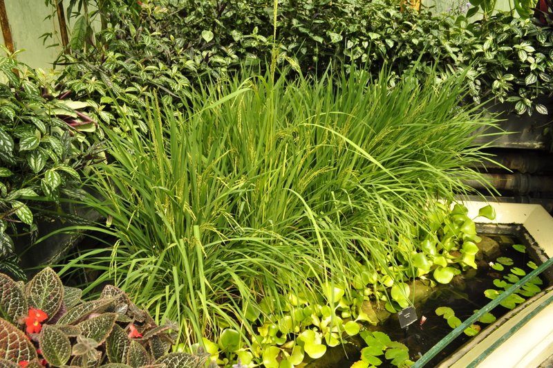
And while many of the economically important cereals were planted in the Grass Garden, there was no rice of course. But we finally tracked it down in two corners of the very hot and humid Waterlily House.
The Rock Garden and the Plant Family beds are separated by a wall and a 150 m path, along which the flower beds are planted exclusively with Salvia species, a lovely sight.
Borders in the Duke’s Garden
The Sackler Crossing over the lake is a relatively new feature at Kew, and is a beautiful addition to the Gardens, curving as it does from one bank to the other.
The Xstrata Treetop Walkway takes you almost above the canopy of the surrounding trees, 18 m above ground. After walking for more than 4 hours, and beginning to feel a little jaded, we opted for the lift to carry us to the top. And what a great view we had from there, although it was a little unnerving to feel the Walkway rock – ever so slightly – from side-to-side.
The Waterlily House is small but contains some beautiful examples of Nymphaea and the giant Victoria cruziana at their best at this time of the year.
In the Waterlily House
Most of the plants are labelled, but it was frustrating not to find one on some plants that we particularly wanted to identify – especially the variety name. Also, Kew has a Plantasia event, with plants all around the Gardens highlighting the life enhancing power of plants – many from Asia used in folk medicines.
Finally, we headed to Kew Palace, once the country retreat of King George III and his family in the 18th century, with its beautiful Queen’s Garden and a sunken herb garden. Exquisite! Of course it’s no longer ‘the country’, but I have to say when walking through the verdant parkland of Kew you can just imagine a world more than two centuries ago, and were it not for the incessant drone of jets landing (almost every minute) at Heathrow (Kew lies directly under the flight-path when aircraft are landing from the east) you wouldn’t know you were just a few miles from the centre of London.
The Queen’s Garden at Kew Palace
Time for tea By 3:30 pm, my ‘dogs were barking’ – that’s to say, my feet were sore. So we headed back to the car and drove the three miles to the Richmond Gate for the other part of our Christmas treat.
Yummy!
After three cups of tea, several finger sandwiches (salmon, ham, egg, all with the requisite cucumber), scones with jam and cream, profiteroles, and Madeira cake, I was a much happier bunny. We were on our way home by about 4:45 pm, and although we encountered traffic congestion approaching the M4 and getting on to the M25 north, it was the open road once we hit the M40 north, and we were home, tired but contented after a great day out, just after 7:15 pm.
Thank you Hannah and Michael, Philippa and Andi for such a lovely treat!
Steph and I have just returned from a three-week vacation in the USA to visit Hannah and Michael and grandchildren Callum and Zoë in St Paul, Minnesota (MN). During our vacation, we took the opportunity of driving from St Paul to Yellowstone National Park in Wyoming (WY) – and stops at all interesting places in between in South Dakota (SD) and Montana (MT). While I will post blogs about the various places we did visit, this post is all about the trip as a whole, and hopefully I can provide a few tips for other lucky travelers.
Almost two thousand miles (actually 1,944 miles from our home base in St Paul to our final hotel in Billings, MT) in eight days might seem excessive to some, but in fact it was quite manageable, and we had time to stop – often for several hours – and enjoy the various places we had chosen to visit on the way. Yes, they were long days, but with open roads and little traffic to hold us up, and the judicious use of cruise control on the main highways, I did not feel particularly tired at the end of the day. In any case, relaxing at our hotel with a couple of cold beers always eased away the tiredness. I kept a couple of packs of beers in the car, and placed some each day in the cooler ready for our arrival the hotel in the evening.
We rented a Kia Sorrento SUV from National at MSP, which cost us USD981 (including a one-way drop-off fee of USD250). We spent only USD274 on gasoline – I hate to think how much a similar journey would have cost in the UK.
And to keep in touch with Hannah and Michael, I purchased a 30-day, 10 cents a minute domestic rate SIM card for my mobile from AT&T (20 cents for text messages); 150 minutes cost USD17 incl. taxes. This was a much better deal than I had been able to find online in the UK. So I would certainly recommend anyone traveling to the US to go to one of the big providers like AT&T (with great coverage throughout the country) and purchase one of these simple SIM plans.
We started our journey west on Monday 2 June, and flew back from Billings to MSP on Tuesday 10 June. This was our itinerary.
Day 1. St Paul, MN – Oacoma (Chamberlain), SD via the Minnesota River valley: 367 miles Route
We left Hannah’s around 08:30 and made swift progress for about the first 10 minutes, until we hit morning rush hour traffic on I-494 W, until we reached our turnoff on US-169 south towards Mankato, MN (site of the largest mass execution in US history on 26 December 1862 of 38 Dakota Sioux native Americans) along the Minnesota River valley. Then we joined US-60 southwest to link up with I-90 heading west into SD. One thing we noticed was how poor the road surfaces were in Minnesota, but they improved dramatically once we crossed the state line into SD, and in fact for the rest of our trip through SD, WY and MT.
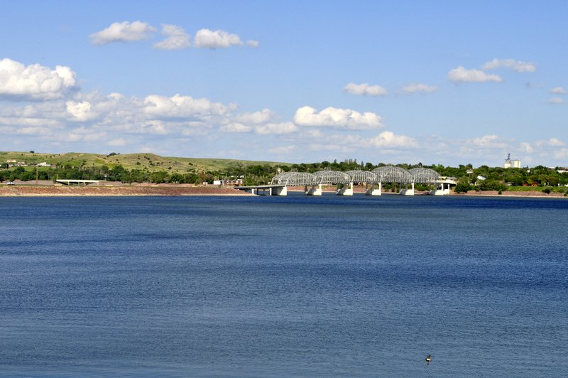
Our destination was Oacoma, a very small community (essentially a motel, RV park, gas station and shops/restaurant) on the west bank of the Missouri River, just across from Chamberlain. We had a glorious day to travel with hardly a cloud in the sky. Here’s a view of the Missouri in the evening sun.
We stayed at the Oasis Inn, Oacoma (score out of 10 = 6); cost (incl. all taxes): USD106
Day 2. Oacoma – Rapid City, SD, via The Badlands: 231 miles Route The day dawned bright and sunny, but we’d seen a warning on The Weather Channel about storms approaching from the west. So although we started out in bright sunshine, it wasn’t too long – in the heart of the Great Plains – that the clouds rolled in, the sky darkened, and the rain came down in sheets. In fact, at one point I found the nearest scenic overlook to turn off I-90 (not that you could see anything) as driving conditions were getting worse by the minute. We saw lots of lightning strikes in the distance, but never felt the full force of the storm – we skirted the northern edge of a major system that wreaked havoc south and east of us, but which had come down from the northwest where, in Billings, baseball size hailstones had done significant damage.
I really was quite naïve when planning this trip way back last February – I didn’t give the possibility of severe weather a second thought. We were lucky since the various storms (that we avoided) did generate tornadoes and even severe thunderstorms had winds of up to 100 mph. You have to take Mother Nature very seriously out on the Plains – there’s nowhere to hide.
However, by the time we reached the turnoff for the The Badlands, it had stopped raining, the clouds lifted, the sun even came out for a while, and we had an excellent four hour trip through the park.
Then we headed for Rapid City and our hotel, where we spent two nights. We ate the first night at the Golden Phoenix Chinese restaurant (very good) and the second at Shooters Wood Fire Grill, just across the street. I had an excellent steak.
Days Inn, Rapid City (7); cost: USD168
Day 3. Mt Rushmore National Memorial and Custer State Park, returning to Rapid City for a second night: 119 miles Route Steph and I both wondered what Mt Rushmore would be like, kitsch or not. And that concern was reinforced on the drive up into the Black Hills from Rapid City – all the many tourist attractions along the highway, and in Keystone, a small community closest to Mt Rushmore. My earliest recollection of Mt Rushmore was in Hitchcock’s North by Northwest (with Cary Grant, James Mason, and Eva Marie Saint).
In fact, Mt Rushmore was very moving and inspiring, we couldn’t have asked for better weather, the cliff-face carvings emphasized by a brilliant blue sky. Then we moved on to Custer State Park south of Mt Rushmore and took our time meandering along the park highways, and through a series of extremely narrow tunnels carved through the hillsides. No RVs here!
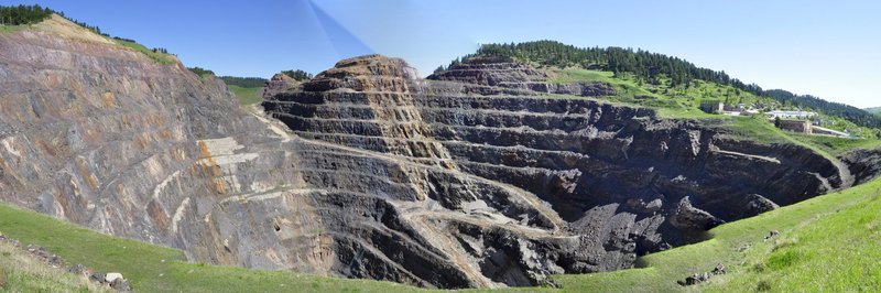
Day 4. Rapid City, SD to Sheridan, WY via The Black Hills, Spearfish Canyon, and Devil’s Tower: 300 miles Route We spent the morning working our way north through the beautiful Black Hills of Dakota and stopped in Lead (as in ‘seed’) to view the huge crater of a former gold mine.
It was the discovery of gold in the Black Hills in about 1870 that exacerbated the conflicts with native Americans. Less than five miles from Lead is Deadwood (of Calamity Jane fame, and the stage), but when we reached the fork on the road junction we turned left to Lead. I regret not turning right and visiting Deadwood because of all its historical connections.
Then we headed north and west to Devil’s Tower, the first site to be declared a national monument, by President Theodore Roosevelt in 1906. Iconic Devil’s Tower featured in Steven Spielberg’s 1977 classic Close Encounters of the Third Kind, and I’d promised myself after seeing the film that I would visit it if I ever had the chance. And I wasn’t disappointed.
Departing Devil’s Tower at about 4 pm, we thought the drive to Sheridan wouldn’t take too long. In fact it was 33 miles to I-90, then, to our surprise (and consternation) we saw that it was still 127 miles to Sheridan! Still, we had a good meal at Sanford’s Pub and Grub.
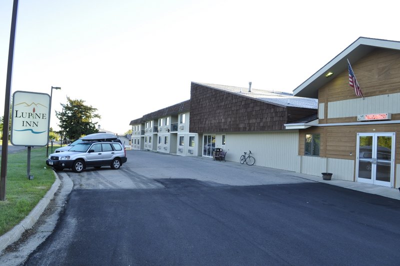
Rodeway Inn & Suites, Sheridan (4); cost: USD93 (in fact, they couldn’t find our reservation. I should have walked away then and found another hotel but after a long drive I was too tired. The room could have done with a more rigorous going-over with the vacuum cleaner).
Day 5. Sheridan to Red Lodge, MT via the Little Bighorn Battlefield: 222 miles Route
This was a big day for me. It dawned overcast and drizzling, with very low cloud, and rather cool compared to the previous days. But as an aficionado of westerns, and I’ve also read quite a bit about the European expansion west during the 19th century, I was intrigued to visit the site of Custer’s Last Stand (I’m currently reading a fascinating account of Custer and Crazy Horse by American author Stephen Ambrose).
There was an interesting display of artifacts in the visitor center, but what I found particularly moving were the marker stones scattered across the battlefield indicating where both US soldiers and native Americans had fallen defending their way of life. And the native American memorial is stunning. But more of this in another separate post.
We stayed this night in Red Lodge, just north of Yellowstone National Park. We had a great pizza at the Red Lodge Pizza Co. on South Broadway Ave.
Lupine Inn, Red Lodge (8); cost: USD88
Day 6. Red Lodge to Jackson, WY via the Beartooth Highway, and Yellowstone and Grand Teton National Parks: 228 miles Route When planning our trip I had no idea of what to expect in traveling into Yellowstone via the northeast gate from Red Lodge. The Beartooth Highway climbs – almost vertically – right over the top of the Beartooth Mountains, and usually remains closed until the end of May when the snow clears. It was a stunning drive.
Yellowstone was both exhilarating – and a disappointment.
There are quite long stretches traveling between tall pine tress, so there’s not much to see. And I guess we have all be spoiled by the amazing wildlife images on TV. While we did see herds of bison, and a few elk, wildlife was not generally conspicuous. I hate to think what then park would be like at the height of the summer season. Bumper to bumper no doubt. Even during our visit we encountered some traffic jams as folks frantically looked for somewhere to pull over to take yet another photo of a lonely bison.
The Tetons are something else. Along Jackson Lake, which lies at just over 6,000 feet, the mountains just rise vertically another 6,000 feet or so. Our destination was Jackson – a winter sports venue for the rich and famous.
Anglers Inn, Jackson (9); cost USD119 (breakfast not included – so we had had the pleasure of that great American tradition: going out for breakfast on the Sunday morning at The Bunnery).
Day 7. Jackson to Cody, WY via Grand Teton and Yellowstone National Parks (Old Faithful): 233 miles Route
We traveled north back into Yellowstone to visit all the hot spring and geyser sites, including Old Faithful. I almost dubbed it ‘Old Faithless’ because we had to wait about 20 minutes longer than expected for it to do its stuff. I say ‘we’ – us and about 500 others. This was no doubt the most crowded part of the park that we visited, but everywhere else we were able to stop, take our time, and take all the photos and video we wanted. Late in the afternoon we headed towards the east entrance to Yellowstone down the highway to Cody – ‘the rodeo capital of the world’, and founded by ‘Buffalo Bill’ Cody. Cody lies about 70 miles east of Yellowstone. We had made hotel reservations outside the national park – at Red Lodge, Jackson, and Cody – and even with having to retrace our steps we decided it was worth it. However, we discovered that the road to the Yellowstone north entrance was being repaired, and significant traffic delays were being reported. So rather than traveling back from Cody to Yellowstone on the last day, we decided to head east.
Grizzly Bear Lodge, Cody (7); cost: USD97
We had dinner at the Proud Cut Saloon, and although the service was rather slow – and I did complain – the flatiron steak I had was one of the best steaks I’ve eaten in a long while.
Day 8. Cody to Billings, MT via the Bighorn Mountains: 244 miles Route And what a smart decision that was, not to travel back into Yellowstone. Instead we headed east into the Bighorn Mountains – and would have reached Sheridan again if we had not turned east again, and then north towards our final destination, Billings.
The Bighorn Mountains rise out of the high plains. On the descent there was a 10% gradient for over 12 miles; sometimes it felt as though we would fall over the edge of the earth. Our hotel in Billings was conveniently located close to the airport. We had a reasonable meal at the local Applebees beside the hotel.
Boothill Inn and Suites, Billings (9); cost: USD128
We spent USD86 on entrance fees to the various national and state parks and national monuments – an exceptionally good deal, since the entrance fee often covers multiple visits over a three to seven day period. Just what we needed for our Yellowstone visit. And the formation brochures that are provided by the National Park Service are excellent. I don’t think we spent more than about USD350 on meals. Each day (except one) we had breakfast (such as it was) in the hotel, and had sandwiches for lunch (or left-overs from the previous night’s meal) supplemented by a yoghurt and a piece of fruit (often filched from the breakfast bar), and a handful of delicious Trader Joe’s Veggie & Flaxseed Tortilla Chips. The evening meal was the ‘expensive’ part of the day, and it was always possible to find somewhere good to eat and not expensive. Not a journey exactly on a shoestring, but not super expensive either.
A long journey, but a great experience. Of course there are so many more details to fill in, and these will be the topics I’ll address in a range of blog posts over the coming weeks.

 The clues are there if you only know how to recognize them. For many landscapes it is quite difficult to determine just what forces of nature sculpted what we see all around us, and frankly take for granted as always having been there.


 Clickety click? You play bingo, don’t you? It’s the 66 ball.


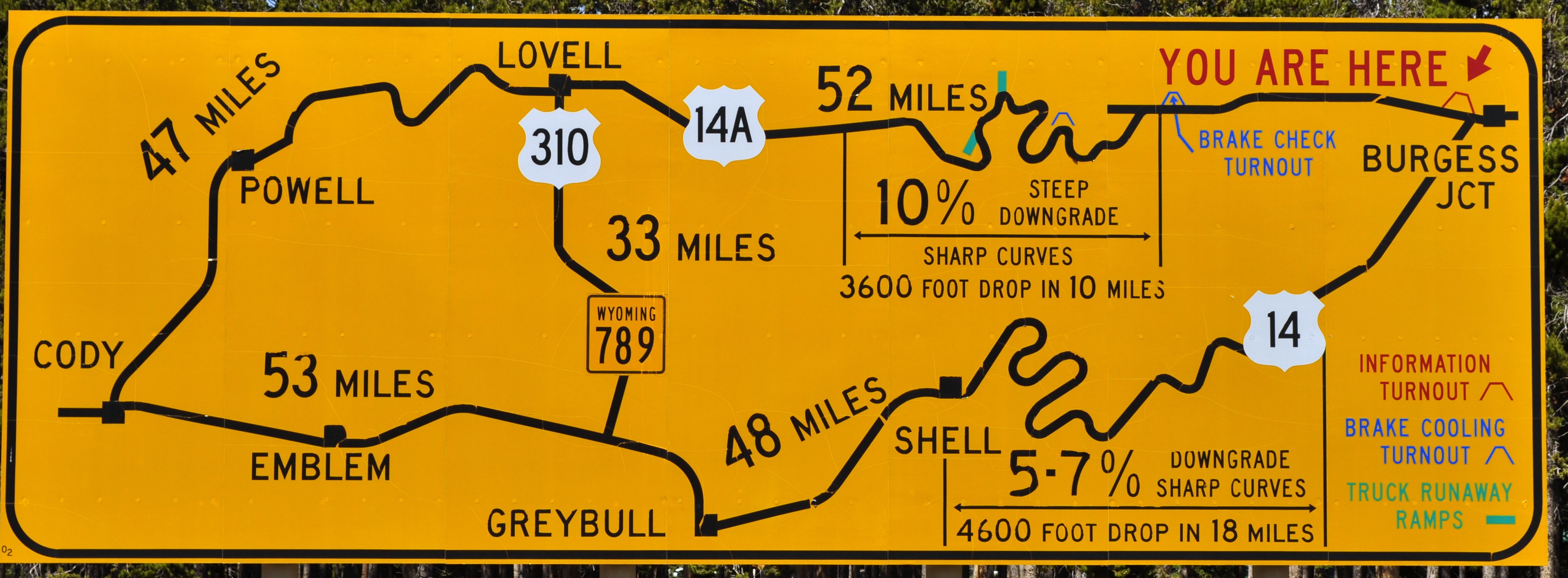
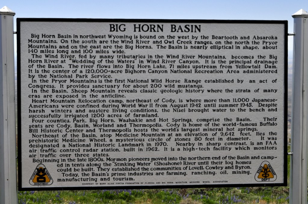


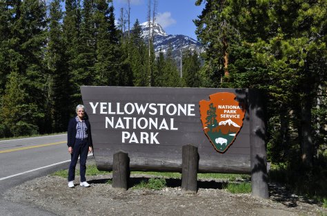


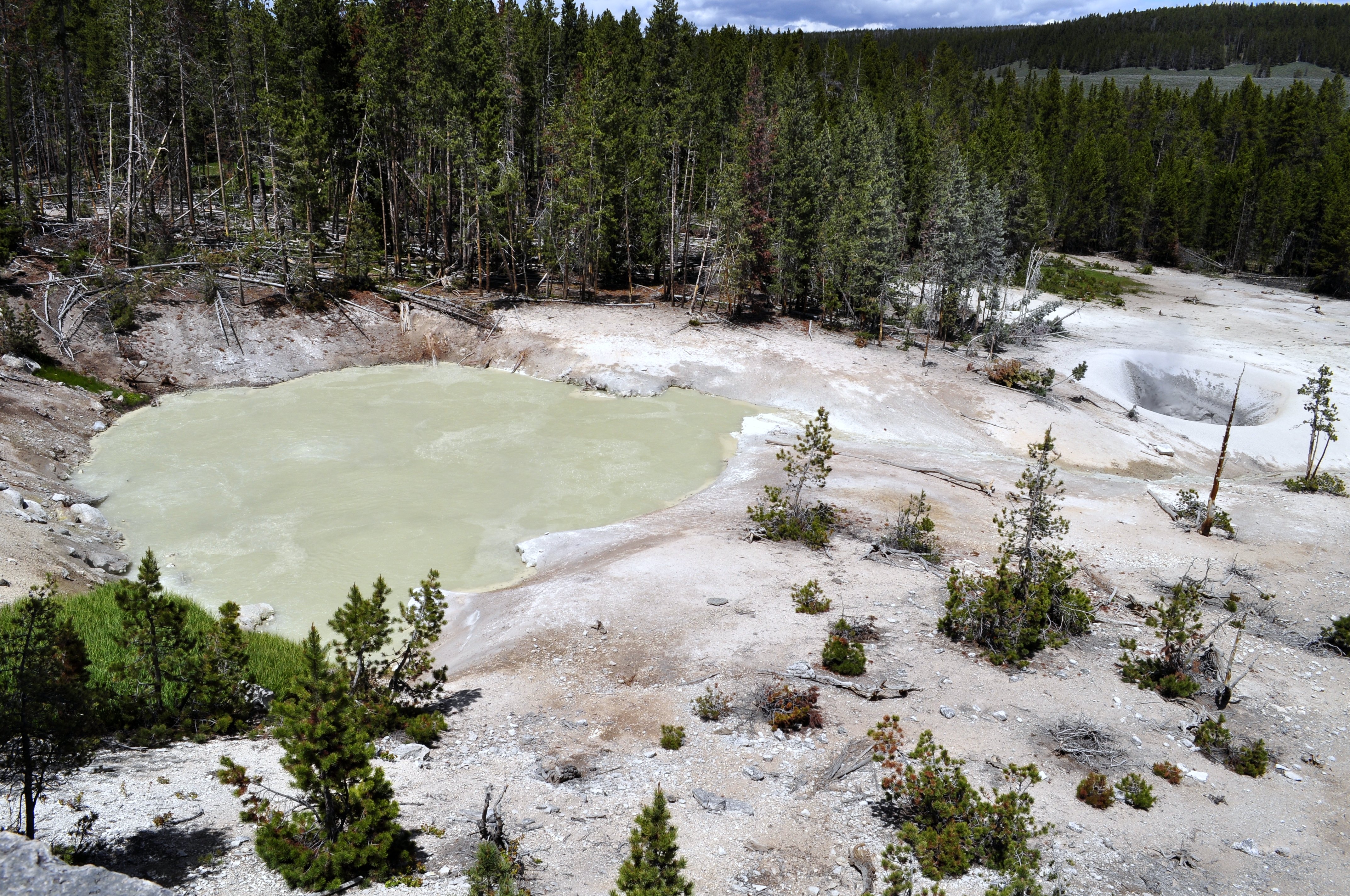


 25 June 1876. Just a few days short of the first centennial of the United States. It took several days for the news to spread to the east coast. Lt. Col. George Armstrong Custer (Bvt. Major General) and many of his 7th Cavalry had been annihilated at the
  Up against Custer on that fateful June day were the combined forces of the Sioux nation – Lakota, Oglala, Minniconjou, and Hunkpapa, as well as Cheyenne, Blackfoot, Arapaho and other allies.
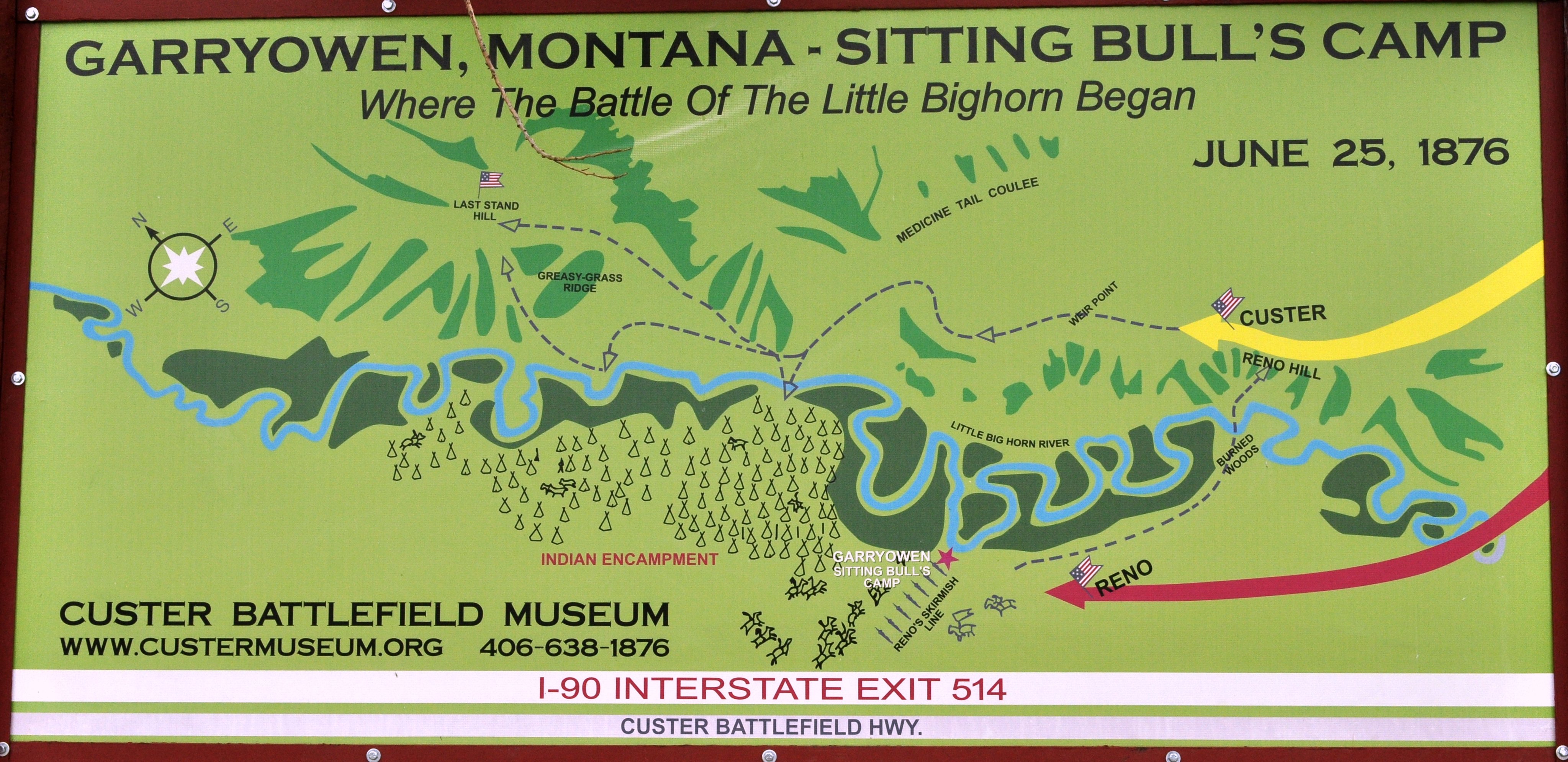
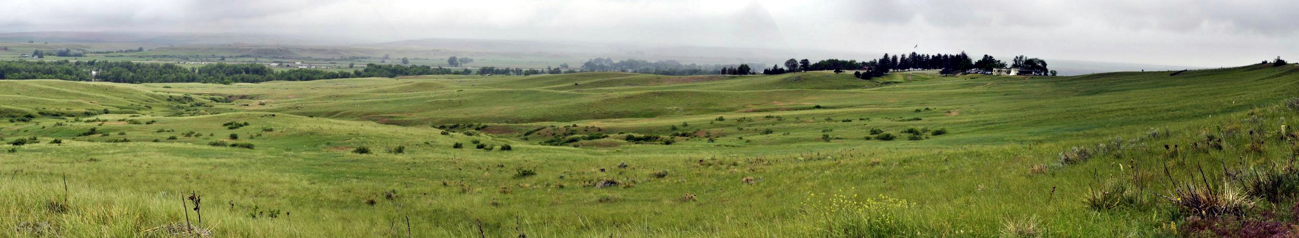


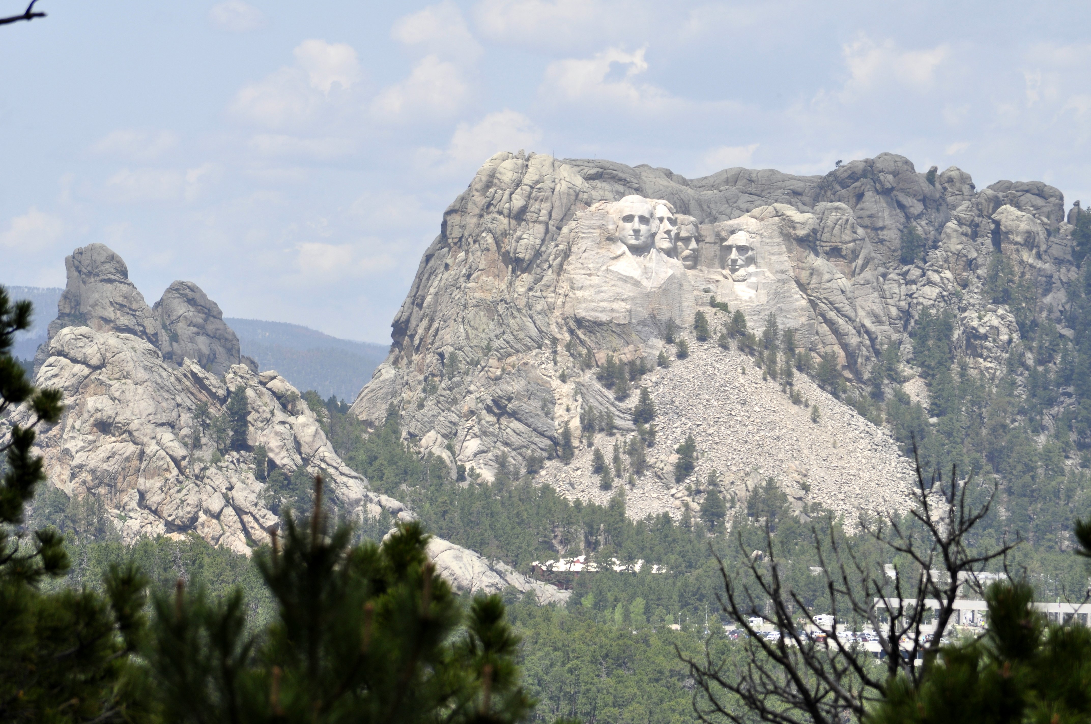
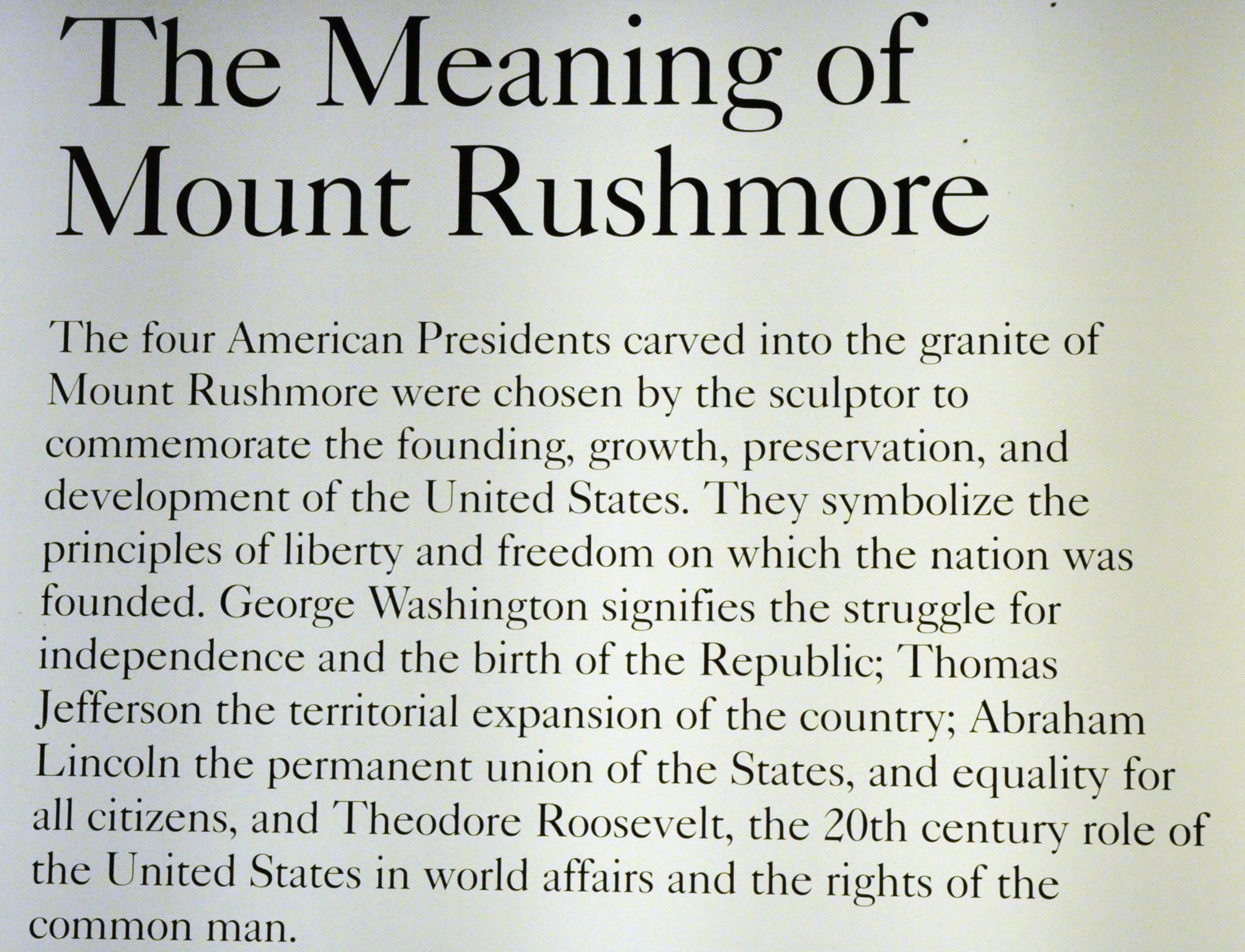


 It was a Tuesday morning, early June. We’d reached Chamberlain, South Dakota on the banks of the Missouri River the evening before, having traveled down from St Paul, MN in glorious sunshine. To the west, however, there was an ominous glower in the sky that was already beginning to darken by breakfast-time. Checking the Weather Channel we learned to expect some thunderstorms as we crossed the Great Plains towards our next destination:
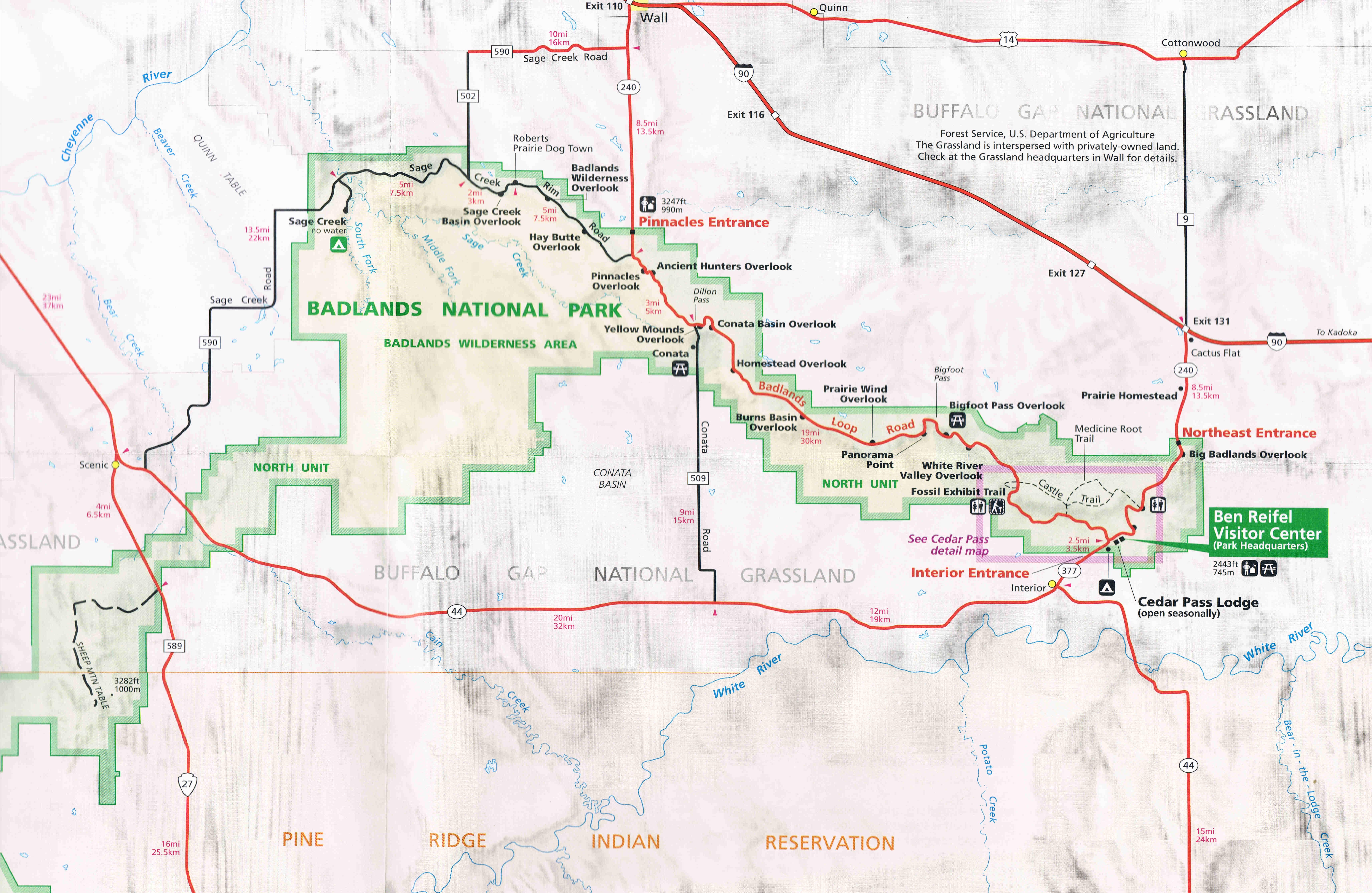
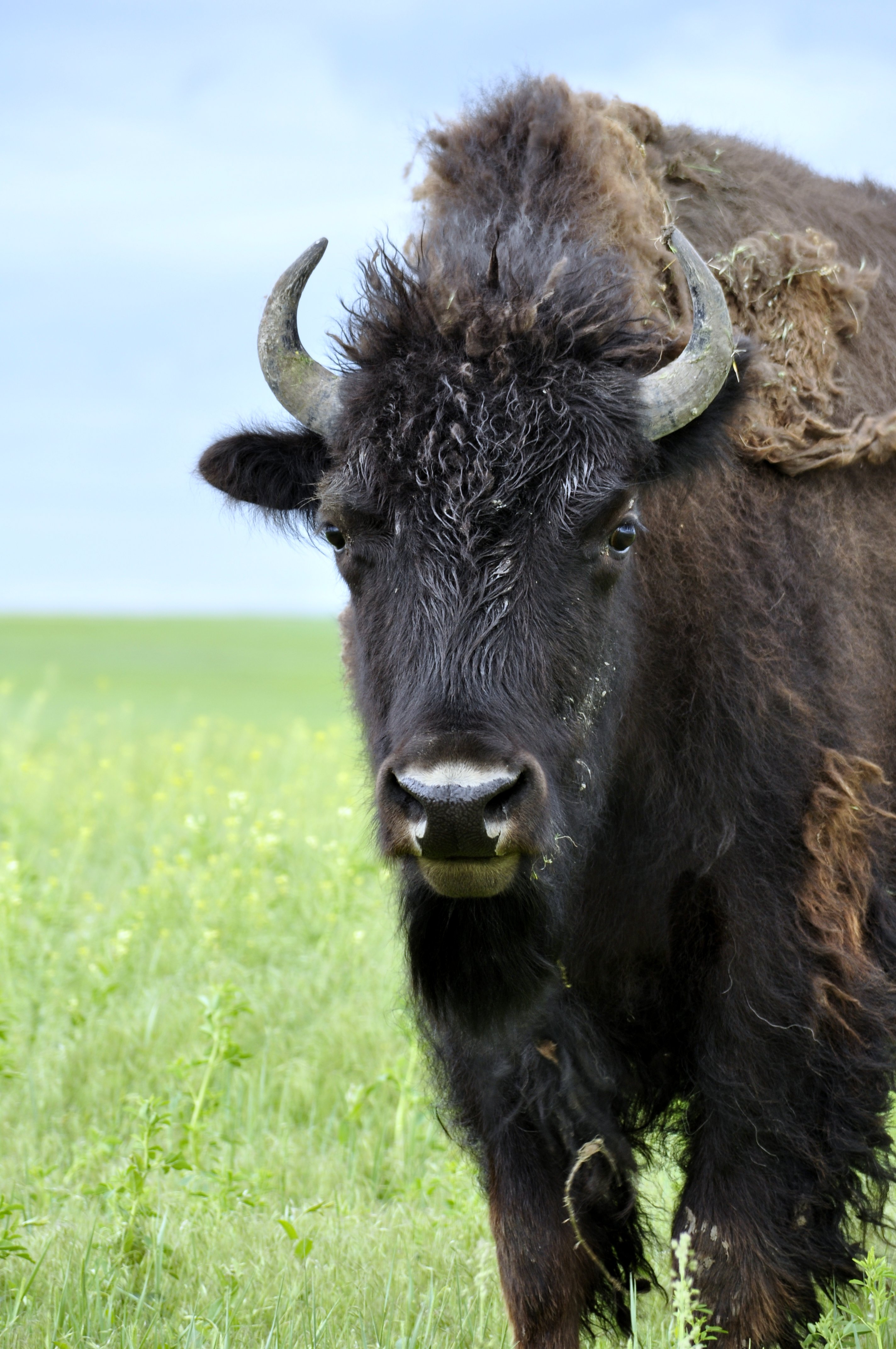


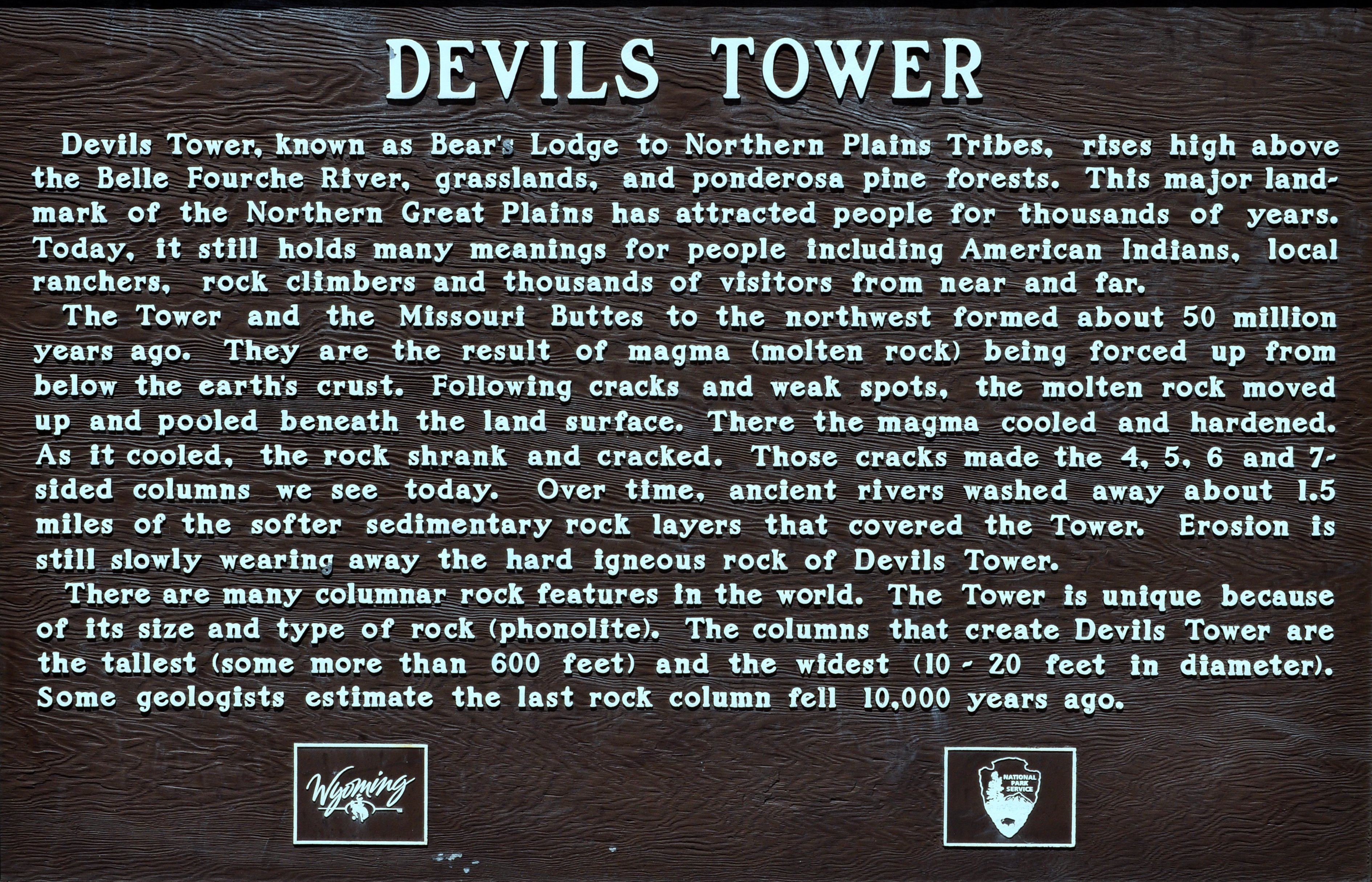
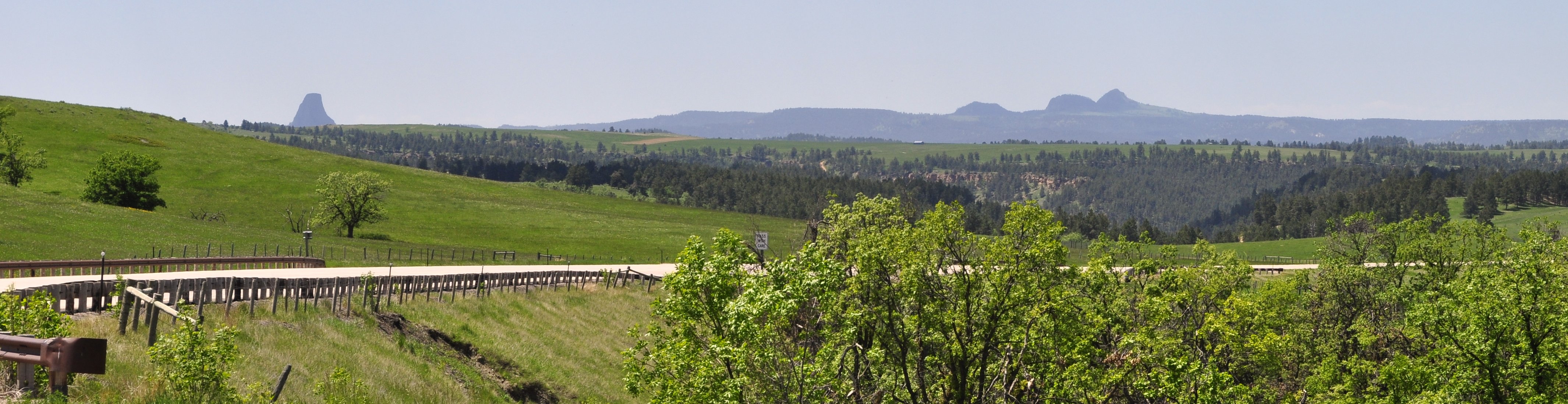
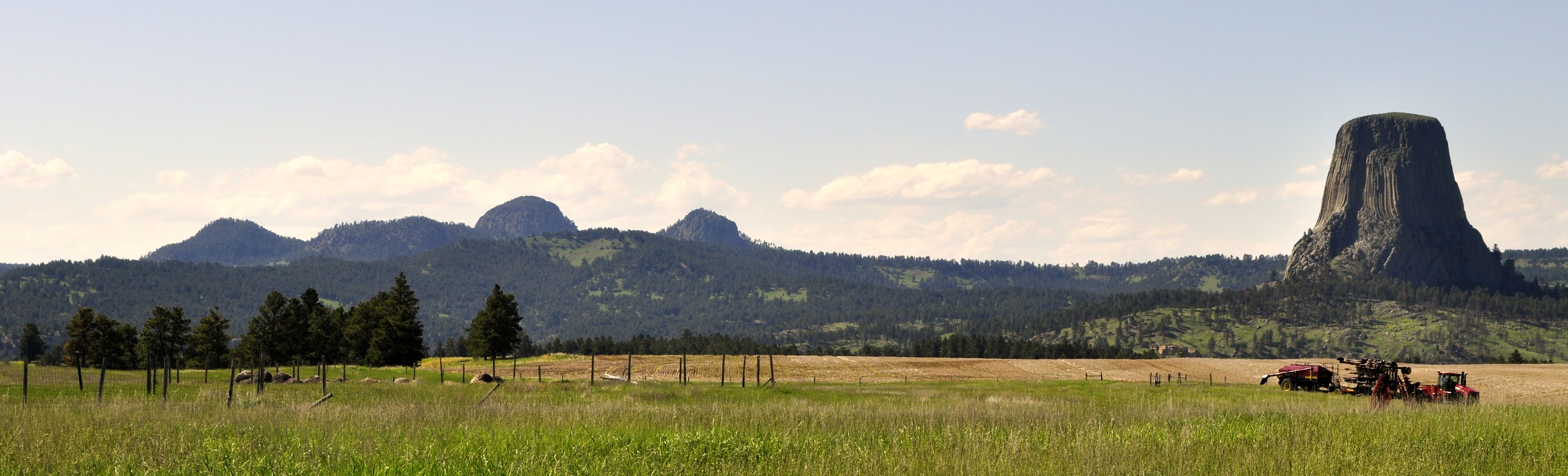
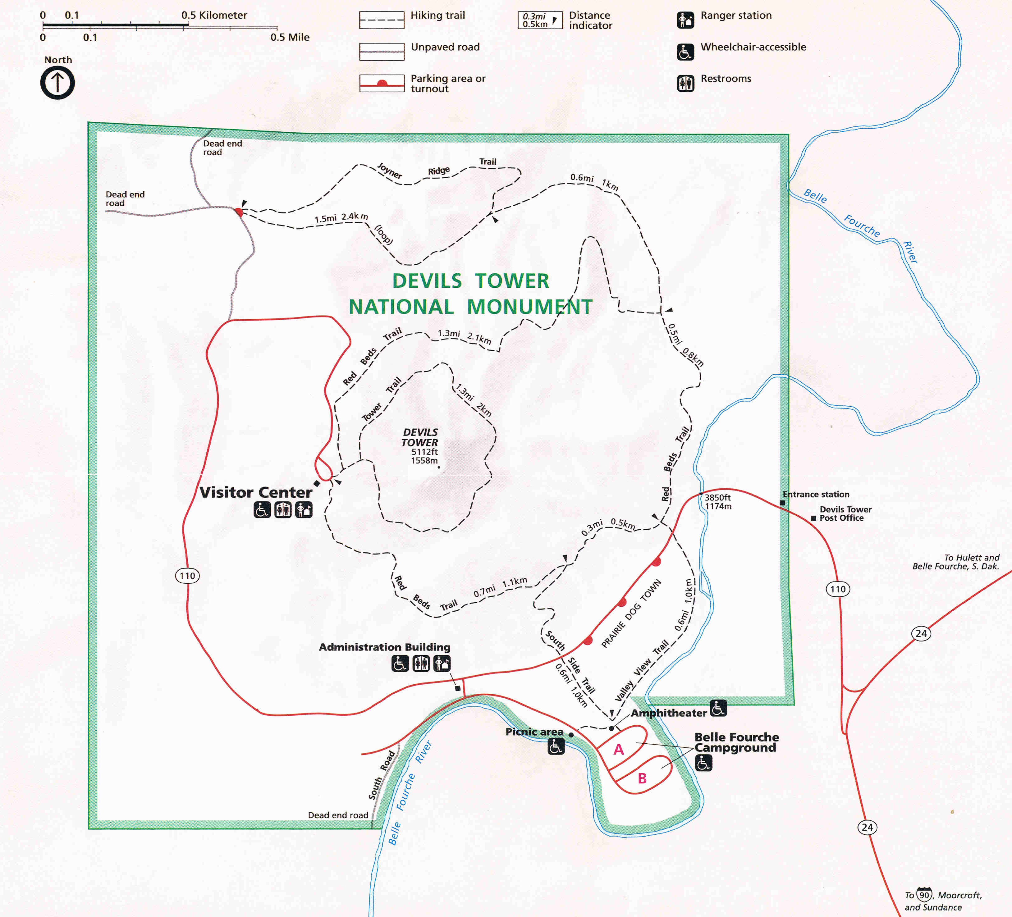


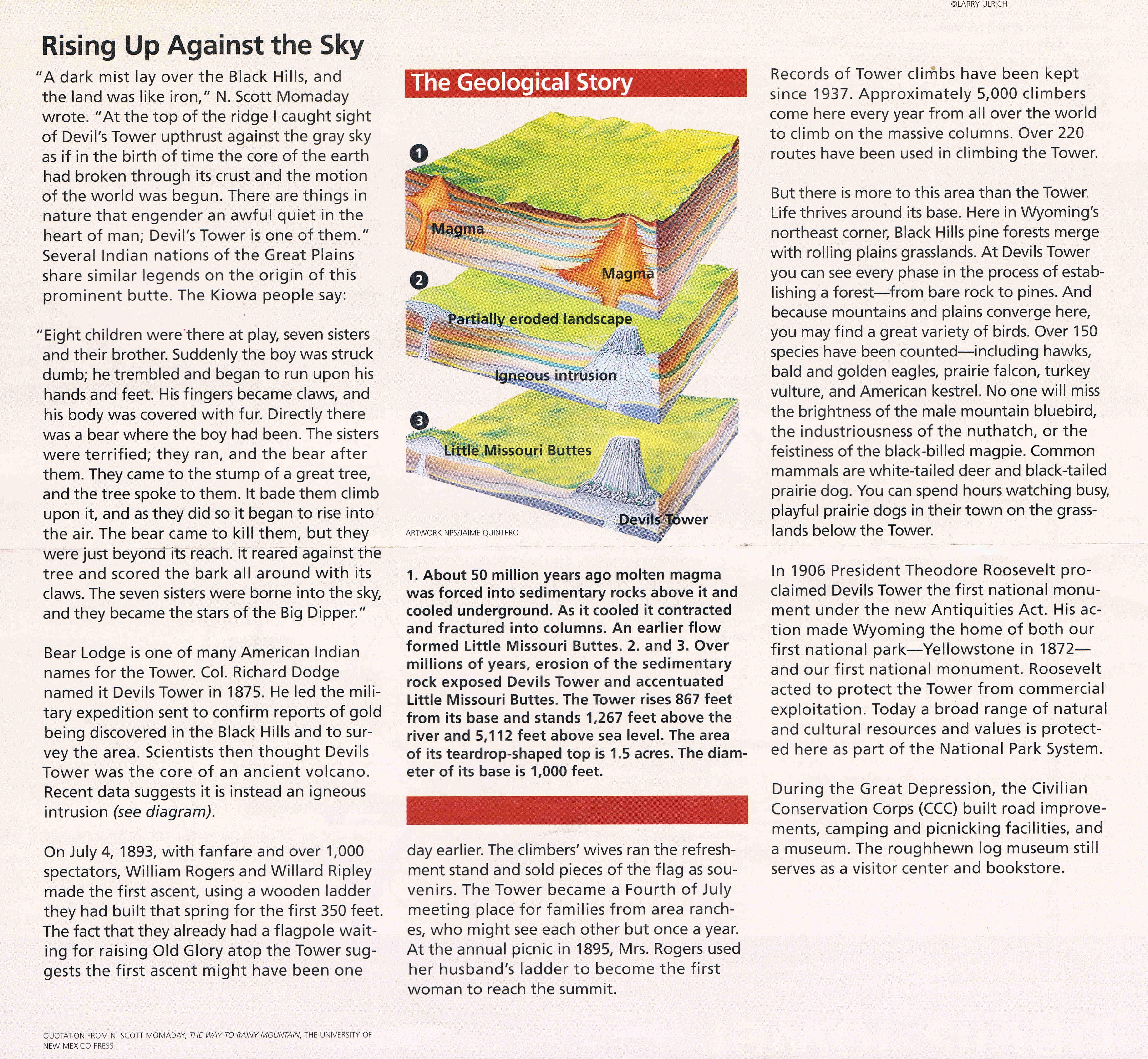
 I began this post last night while waiting for my Emirates flight to Dubai in the Pacific Club Lounge in Terminal 3 at Manila’s Ninoy Aquino International Airport. I am now in Dubai waiting for my onward connection to Birmingham.


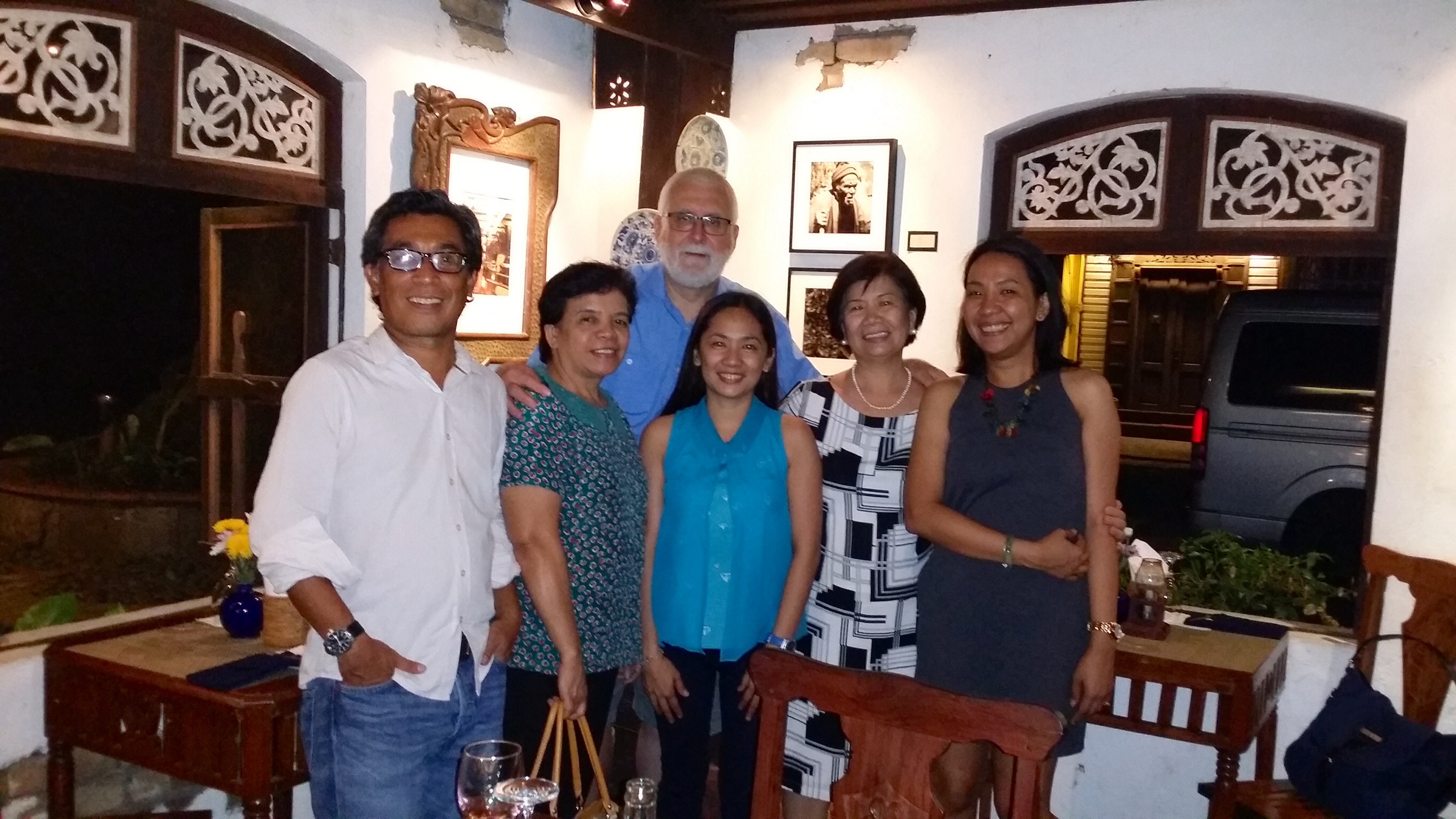


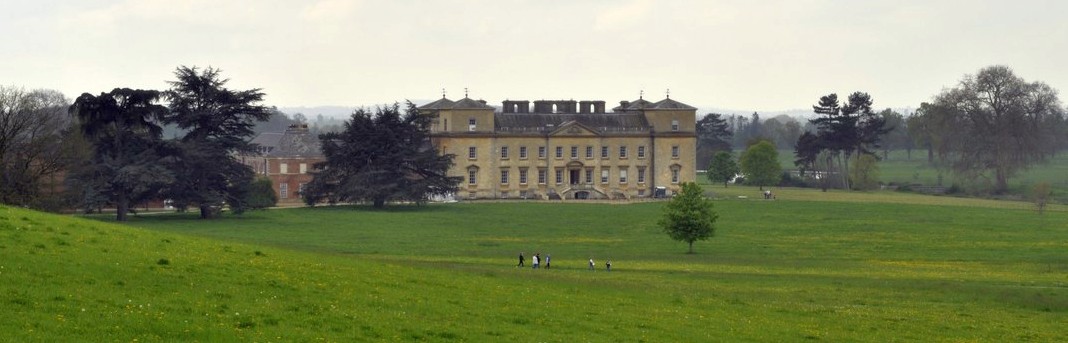
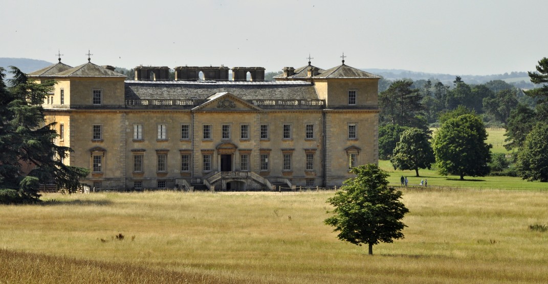
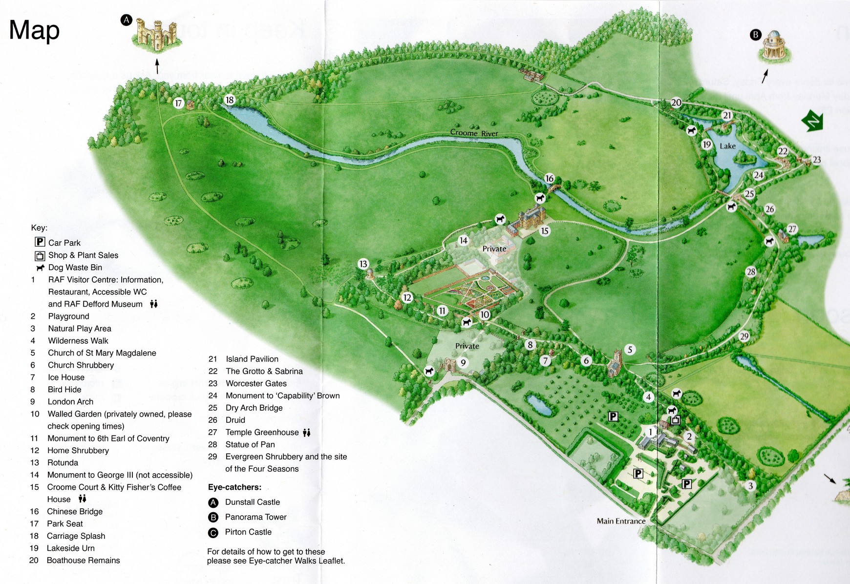


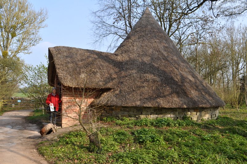
")


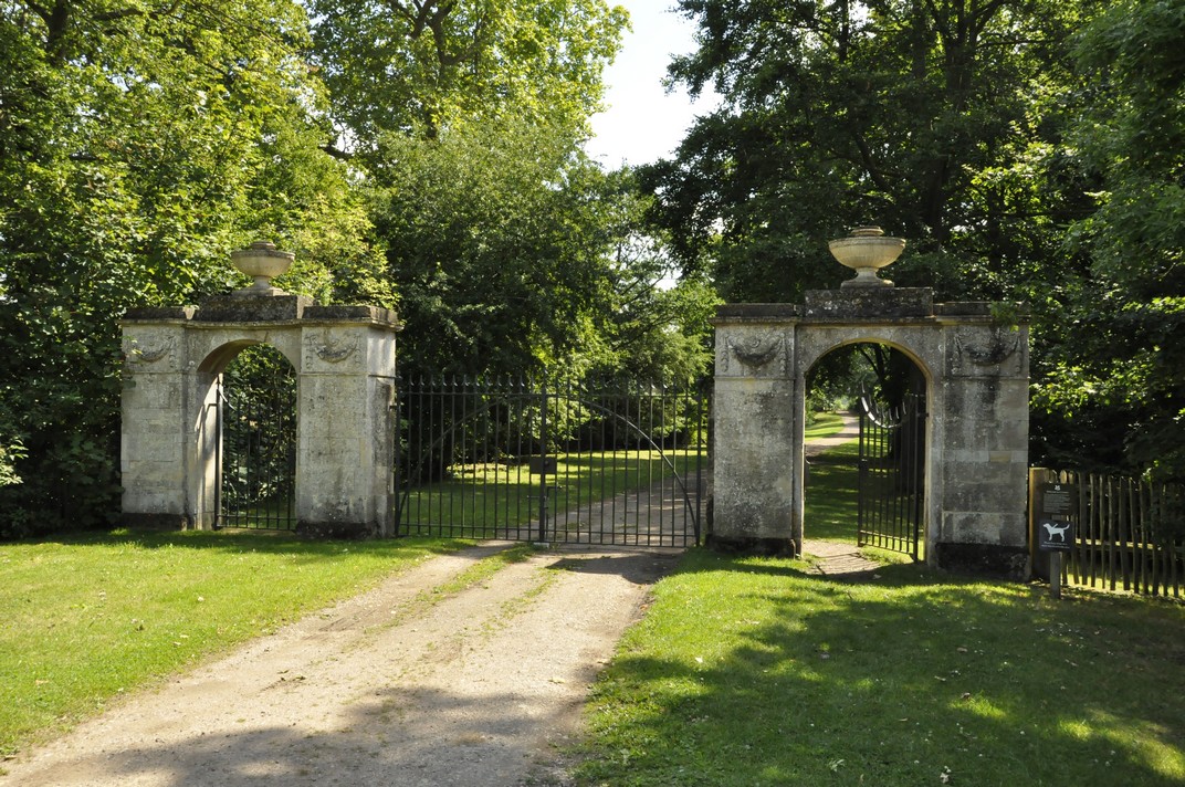


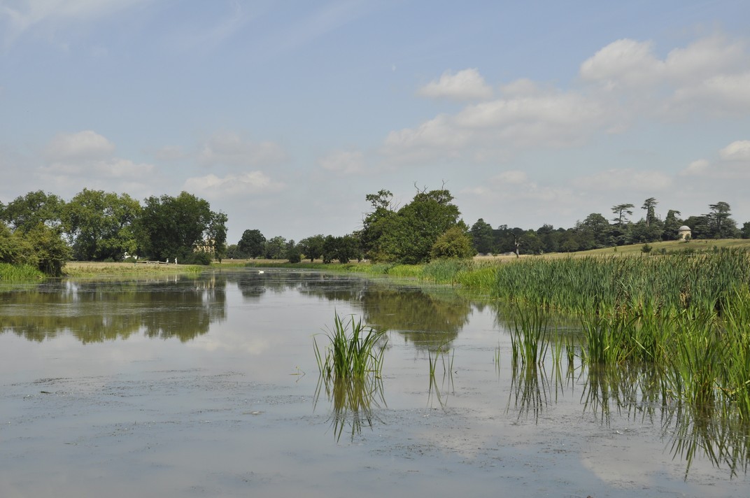
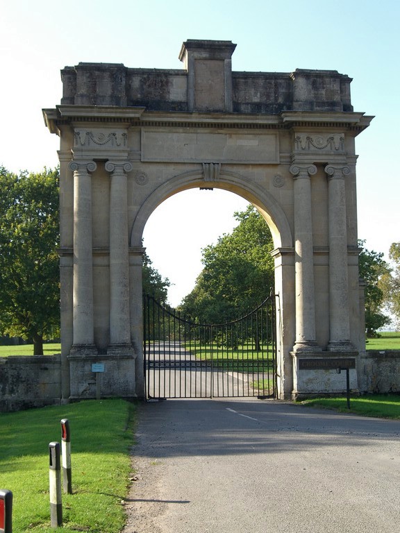
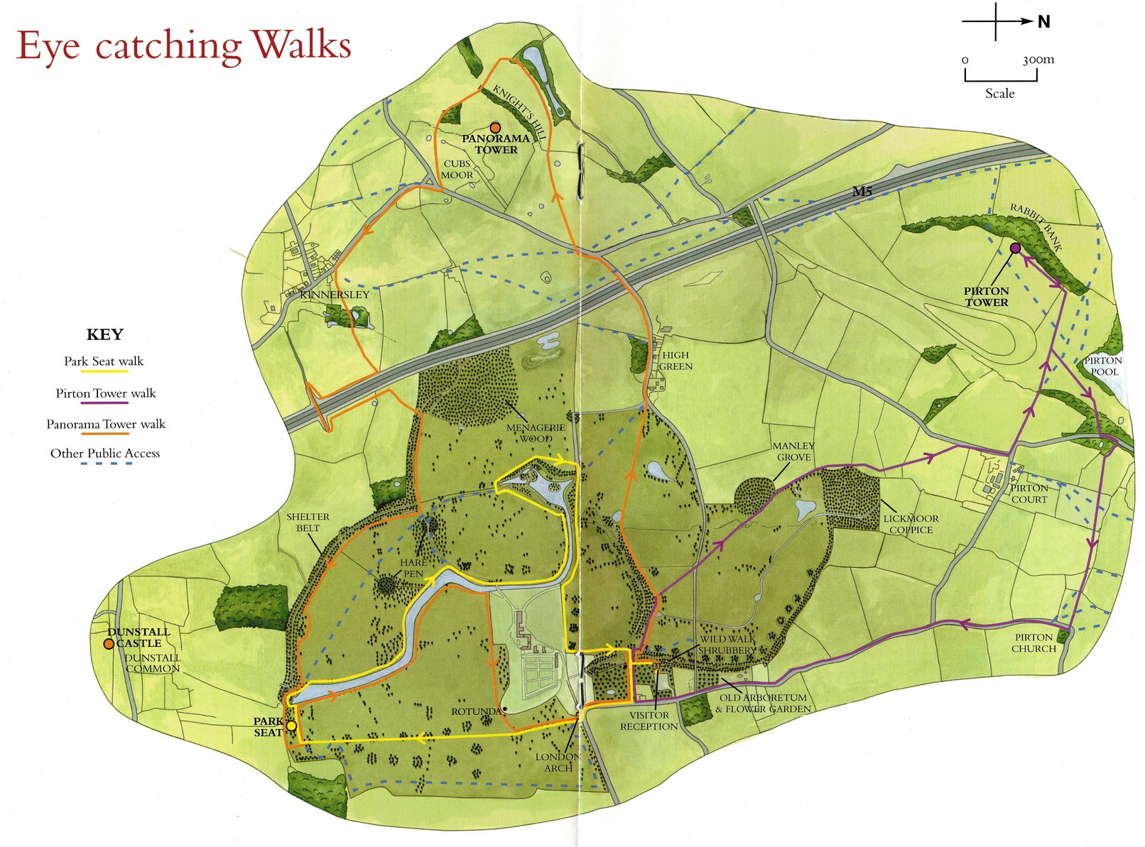


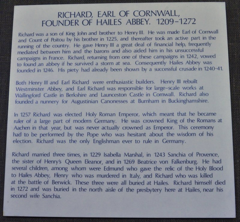
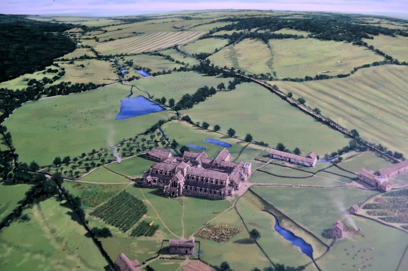


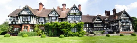


 Kew Gardens does not offer much parking, and there are restrictions on all the streets nearby, except Kew Road (which quickly fills up, apparently) but only after 10 am. Searching the Internet last weekend, I came across a site I’d never encountered before: