USA 2024 (2) – On the road again

Well, after our road trip in 2019 I ‘promised’ myself that would be the last one. And although enjoyable, maybe I pushed myself a little too much; I found it rather tiring.

Tuesday 14 May. And here we were preparing to jet off to Las Vegas to begin another trip, this time across Utah and Colorado over the next seven days.

It was an early start to the airport for the 07:00 flight to LAS.

As I mentioned in my recent post, I already had a route planned and all our hotels booked. But the route was always subject to change, and that’s precisely what happened once we were on the road and could see the progress we made each day.

Now back in Minnesota I’ve been editing >1100 images and have placed them in photo albums at the end of this post.

I also used my dashcam throughout the whole trip, so I’m busy editing >222 GB of footage into short videos, some of which are included in the narrative below.

When I was planning this trip, and in touch with my old friend and former colleague, Roger Rowe, he suggested I should play Willie Nelson’s On the Road Again as a background theme to our travels.

Well, I’m not a particular Willie Nelson fan, but his words certainly resonated each morning as we set out on each leg of the trip, that I’ve documented here with maps and descriptions of the many interesting places we visited along the way, over more than 1600 miles. And, my British readers will be surprised to learn, at a gasoline cost of only £0.06 (6p) per mile.


Day 1: 14 May – Las Vegas, NV to St George-Washington, UT via the Hoover Dam (185 miles)
After a three hour flight from Minneapolis-St Paul (MSP) we landed in Las Vegas on time just after 08:00 and, having only hand luggage, were quickly out of the terminal, catching the shuttle bus to the car rental center south of the airport. Which was a good location for us as we were headed southeast to the Hoover Dam.

I’d booked an intermediate SUV through Alamo, and the pickup in LAS was quick and efficient. Choosing a VW Tiguan (with California plates) among several options on offer, we must have been on the road just after 09:00, heading for a supermarket en route to pick up supplies of drinking water, fruit, and other snacks for the trip.

Construction of the Hoover Dam, straddling the Nevada-Arizona state line, began over 90 years ago, and it was commissioned in 1935. What a magnificent example of engineering expertise of the time. Walking across the dam, and taking in its art deco features, you can’t help wonder at the sheer scale of its construction. And the Mike O’Callaghan-Pat Tillman Memorial Bridge, which opened in 2010, is the second highest in the USA and carries Interstate 11 and US Route 93 over the Colorado River. You can really appreciate the scale of this bridge in this video.

We arrived late morning, parked in the covered car park (worth it, at $10 a time, since the temperature was approaching 100°F). Later on we drove across the dam to the Arizona side (and a different time zone) to eat our lunch overlooking Lake Mead, and noting just how low the water level had become.

Then it was time to head north for our first stop of the trip in St George-Washington just over the Arizona-Utah state line.

The route we took passed through the Lake Mead National Recreational Area, offering great views of the lake and the mountains in the distance, before joining Interstate 15 for the final 70 miles.

Day 2: 15 May – St George-Washington to Bryce Canyon City via Zion National Park and Bryce Canyon N.P. (207 miles)

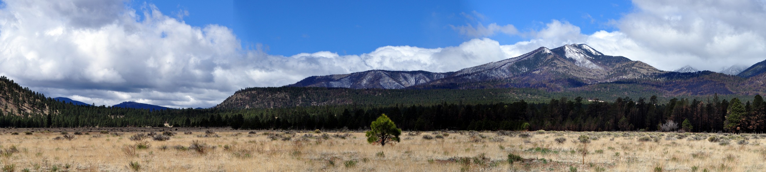
First stop of the day was Kolob Canyons, part of Zion National Park, some 30 miles north of St George-Washington.

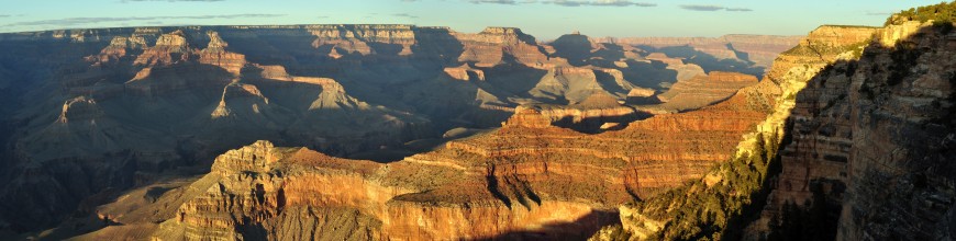
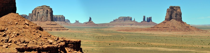
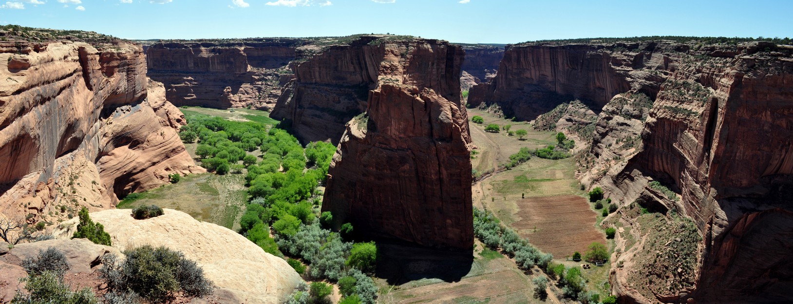
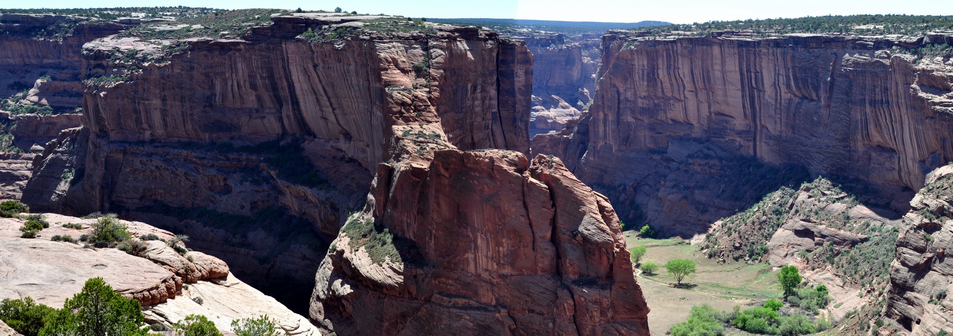
There’s just a 5 mile road from the Visitor Center to an overlook point over the canyons to the east. This was our first introduction to ‘canyon country’ on this trip (we’d visited the Grand Canyon and Monument Valley in 2011).

Then, retracing our steps a few miles, we took Utah Scenic Highway 9 through Zion National Park eastwards to Carmel Junction.

Zion was heaving with tourists and this wasn’t by any stretch of the imagination the peak season. All campgrounds were full, and there was no parking available at the Visitor Center.

It was never our intention to take the shuttle into the canyon itself, but just drive through. And what a drive it was with magnificent red sandstone cliffs rising all around.

Even though we took our time to drive through the park, we realised that we would reach Bryce Canyon by mid-afternoon. And, rather than delay that visit until the following morning, decided to enter the park there and then, and actually benefitted by seeing some of the more iconic landscapes in the late afternoon sun. Landscapes to make your heart sing. As the park brochures states: Red rocks, pink cliffs, and endless vistas! The sandstone pillars reminded me of China’s Terracotta Army.

Day 3: 16 May – Bryce Canyon City to Moab, UT via Grand Staircase – Escalante National Monument (290 miles)
We set out early on Day 3, knowing we had one of the longest drives of the trip to reach Moab. As we had originally planned to tour Bryce Canyon that morning, I had chosen a route to Moab taking in the major roads, knowing it was likely to be faster. But with the whole day to reach Moab, and discovering that the route across the desert, Scenic Byway Route 12 (SR-12), through the Grand Staircase-Escalante National Monument, is also designated as an All-American Road, and not as remote as I had imagined just looking at a highways map.

What an experience, and definitely a must-travel route if you are ever in that area.

Look out for the ‘Hogback’, where the road has sheer drops on both sides, just after 18 minutes in the video below.

Reaching I-70 by mid-afternoon, we made good progress to Moab as the speed limit on this interstate was 80 mph. A mostly boring drive, but with one spectacular section.

Day 4: 17 May – Moab to Grand Junction, CO via Arches N.P. and Canyonlands N.P. (231 miles)

Arches National Park is just a few miles north of Moab, and beyond the park entrance, there’s an impressive climb along the cliff face to enter the park proper. Admission to the park is by timed tickets, and I’d reserved a slot for 08:00 as soon as they became available in early April.

Arches is a ‘closed’ park, with entrance and exit the same, with a drive of about 18 miles to the furthest point, the Devil’s Garden Trailhead. I was quite surprised how fast and determined many drivers seemed to be heading there, until we also arrived there about three hours later and found there were no parking spaces at all.

But that didn’t bother us, as we were more than happy to potter along, stopping wherever we could and just taking in the most incredible scenery, and views of the La Salle Mountains to the southeast.

We spent most time walking up to the Two Windows arches and Turret Arch (I guess a little over a mile in total), where there were wonderful views over the park.

We saw the free-standing Delicate Arch from a lower viewpoint. The walk to the arch, about a mile, up a steep cliff face, and in the blistering heat was beyond our capabilities by that point.

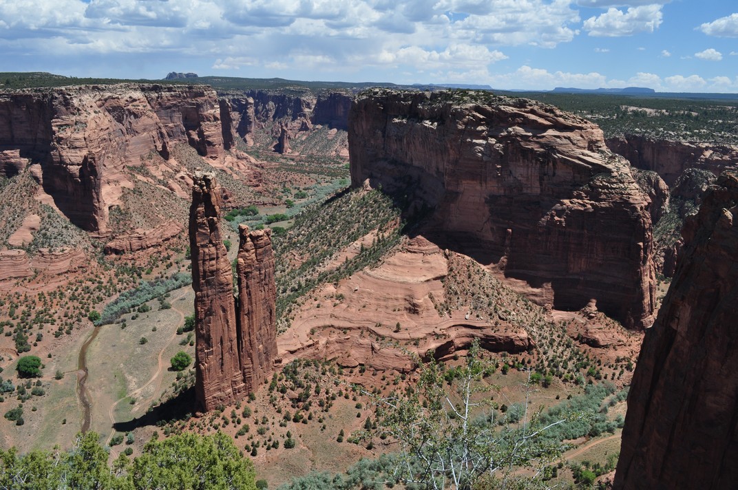
After a picnic lunch at Panorama Point, we headed out of the park north to where UT 313 peels west from US191, towards the entrance gate to Canyonlands National Park. It’s a 34 mile drive southwest to the furthest point at Grand View Point.

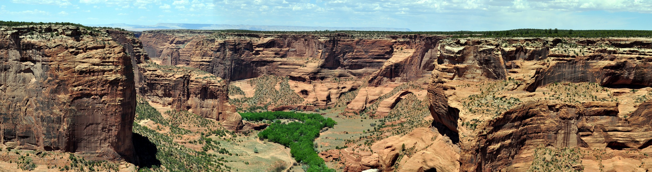
Canyonlands is the Grand Canyon on a smaller scale, overlooking the Colorado and Green Rivers and their confluence to the south. It’s so vast it was hard to take it all in.

Late afternoon, and we headed north again to re-join I-70 for the remaining 81 miles to Grand Junction, CO and our next hotel stop.

Day 5: 18 May – Grand Junction to Durango via the ‘Million Dollar Highway’ and Mesa Verde N.P. (291 miles)
This was always going to be the most challenging day of driving, crossing several passes in the San Juan Mountains, on the ‘Million Dollar Highway’ between Ouray and Silverton.

I’d already done my research about the ‘Million Dollar Highway, read reports, and watched various videos on YouTube. Almost all said the highway was not for the faint-hearted, because of the gradients, sharp curves, and steep and deep drop-offs with no guard rails. Had it been raining heavily (we only had a short shower as we left Ouray), foggy, or icy I probably would have chosen another route to Durango.

However, looking back on this section of our trip, it was not as challenging as others would have you believe. We went slowly, and I used semi-automatic use of low gears whenever necessary. Frightening? No, it was exhilarating, crossing three passes at over 10,000 feet, the highest being Red Mountain Pass at 11,013 feet (or 3358 m).

There were few places to stop to take photos, although I was able to capture stills from the video footage.

Having left Grand Junction by 08:00, and even taking into consideration the slower traverse of the mountains, we arrived in Durango by early afternoon, so decided to continue on to Mesa Verde National Park, about 35 miles west, rather than leaving the visit for the following morning.

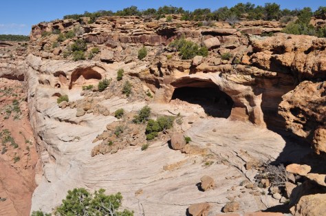
The park is a World Heritage Site, where communities of Ancestral Pueblo people lived for over 700 years, building dwellings on the mesa and cliffs. It’s hard to imagine what drove these Ancestral Puebloans to choose such sites for their houses and temples half way up sheer cliff faces. Caught in the late afternoon sunshine they were indeed impressive.

One location we stopped at was the Montezuma Valley Overlook (map). In July 1958, while leading an expedition to collect wild potato species in the USA, Mexico, and Central America, my PhD supervisor and mentor, Professor Jack Hawkes, stopped here and took the photo on the left below. Here I am at the same spot almost 66 years later.

Then it was back into Durango for the night, just in time to catch one of the best grass-fed beef burgers I’ve tasted in a long while.

Day 6: 19 May – Durango to Cañon City, CO via Chimney Rock National Monument (272 miles)
I’d chosen Cañon City as our next destination as I wanted to view the Royal Gorge Bridge (‘America’s Bridge’, and the highest in the country) standing 955 feet (or 291 m) above the Arkansas River.

This was just a travel day, with no scheduled stops. That is until we saw a sign, about 29 miles east of Durango, that the Chimney Rock National Monument was just 26 miles ahead. Well I’d never heard of this location, nor had spotted it on the maps I had prepared for the trip.

Anyway, at the turn-off, we noted that the monument was just a handful of miles south from the main road US-160E. What a find!

Chimney Rock National Monument is an Ancestral Puebloan site, with an impressive kiva on the summit of the mesa, and just a stone’s throw from the twin peaks, Chimney Rock and Companion Rock, that give the site its name. Fortunately there’s a dirt road almost to the summit of the mesa, and from there to the buildings is a quarter mile walk, and 200 foot ascent (which I did very carefully).

But what a view from the summit, all the way into New Mexico.

At Chimney Rock, we’d hardly dented our journey to Cañon City, and having spent just under two hours there, with more than 200 miles more to travel (and over several mountain ranges), we didn’t reach our destination until around 19:00. And we were lucky to find somewhere to dine, as it was a Sunday evening.

This next video shows the ascent into the mountains on US-160 beyond Pagosa Springs, crossing Wolf Creek Pass summit at 10,856 feet, and descending towards South Fork.

Day 7: 20 May – Cañon City to Denver via Royal Gorge Bridge and the Florissant Fossil Beds National Monument (184 miles)
Built in just six months in 1929, the Royal Gorge Bridge used to carry a road over the gorge, but is now closed to traffic. It stands within a resort and theme park, and pedestrians are allowed to cross – if they dare! It wouldn’t suit me; I suffer from vertigo.

I failed to find an unofficial viewpoint that would have given us a great view down the deep gorge, so had to make do with those from the resort car park.

Then it was off to the Florissant Fossil Beds National Monument, just under 50 miles north, one of the richest and most diverse fossil deposits in the world. Petrified redwood stumps up to 14 feet wide and thousands of detailed fossils of insects and plants reveal the story of a very different, prehistoric Colorado.

Even though off the beaten track, so to speak, we were somewhat surprised how many other visitors showed up shortly after we arrived a few minutes after the opening time of 10:00.

The fossilised redwood trees are indeed impressive, buried in a volcanic mudflow or lahar 34 million years ago, as was the revelation that the monument is probably one of the fossil hotspots in the world. Here’s a film from the National Parks Service about the site.

We took the Petrified Forest Trail (about 1½ miles), viewing some of the redwoods, including Big Stump.

Then, we headed to Denver for our last night on the road, at a hotel near the airport, just as a major storm hit town with hailstones the size of marbles. In fact the last 60 miles after we joined US-285 and then I-70 once again, with several lanes of fast moving traffic, were quite a shock to the system after driving along relatively deserted rural roads for the previous week.


But we reached Denver safely, enjoyed a good night’s sleep before departing for the car rental center around 08.15, in order to catch our flight back to Minnesota at 11:15.

It’s quite illuminating to compare the landscapes around Denver (big agriculture, and very flat with the Rockies to the far west of Denver) with the arrival into leafy Minneapolis-St Paul.

What a wonderful trip! It’s quite hard to choose the highlights, but from a landscape point of view I’d have to choose Bryce Canyon, and the ‘Million Dollar Highway’ and other routes over the Rockies.

Hotels were variable. We always choose a budget or mid-range chain. All we want is a clean room, bed, and bathroom before moving on the next day. What we did notice, however, is how much more expensive hospitality and accommodation has become in the US.

So that’s that for 2024, abroad at least. We are having a week away in East Anglia in the UK during September.

Will we make another US road trip in 2025? Maybe, but currently we’re more inclined towards a three day break in New Orleans, a city we’ve wanted to visit for a long time.


One of the most beautiful places I have visited . . .

Recently, I was asked to choose one of the most beautiful places I have visited. Well beauty lies, as the saying goes, in the eyes of the beholder. What one person finds appealing leaves another cold.

However, to choose just one place, that really is a challenge. But I’m up for it!

I have visited more than 60 countries, and whenever possible, took a day or so from my busy schedules (mainly at weekends) for some sightseeing. So there are many candidates to choose from.

I lived abroad for almost 28 years, in Peru and Costa Rica between 1973 and 1981, and in the Philippines from 1991 to 2010. Our elder daughter lives in the USA (in Minnesota) and Steph and I have visited each year since 2010 and traveled extensively across that vast country. Until Covid put paid to our plans, that is.

In the Americas, I could choose Crater Lake in Oregon, the Grand Canyon and Monument Valley in Arizona, or the giant redwoods of northern California. Not to mention the many spectacular rivers we have crossed or the mountains like the Tetons and Appalachians we have traveled along.

In Central America, we visited the Aztec temples north of Mexico City, the ruins of Tikal in Guatemala, and the Monteverde Cloud Forest in Costa Rica. In Peru, there’s the awe-inspiring Machu Pichu, and well as the beauty of the Andes mountains.

In Europe, I fulfilled a life-long ambition to see the Matterhorn, and almost anywhere you travel in Switzerland is chocolate box beauty.

My travels in Africa have taken me to Ethiopia and Kenya in the east, and the magnificent Rift Valley, and to regularly to Nigeria and Ivory Coast in the west.

Water buffalo in the Nairobi National Park, Kenya

Traveling around Asia, I spent many happy times in Laos, and on one occasion Steph and I managed to snatch a weekend away in the ancient capital of Luang Prabang, and take a trip up the Mekong River. In Cambodia, we’ll never forget our visit to Angkor Wat, while the beauty of the Bali landscape and beaches is firmly embedded in my mind. In the Philippines, we visited the coast at Anilao as frequently as possible, about nine visits a year, where Steph would snorkel and I would scuba dive over some of the most diverse coral reefs in the world. And again, there’s the wonder of the rice terraces in the mountains.

Heading further south, our travels have taken us on several occasions to Australia and one memorable road trip of 1000 miles from Sydney to Melbourne taking in the spectacular coastline.

Wilson’s Promontory, Victoria, Australia

And not to miss out on locations closer to home such as the Giant’s Causeway in Northern Ireland, or the landscapes and beaches along the Northumberland coast where we now live.

But how can I distill all these experiences down to just a single choice? It’s very hard indeed. But in doing so, and I will reveal my choice shortly, I have also taken into consideration not only its intrinsic beauty, but the location, history, and emotions it stirred. And when I combine all these elements, I have chosen the one place (not yet mentioned) I would return to tomorrow, given half the chance.

And where is this particular jewel? Canyon de Chelly National Monument (pronounced Canyon de Shay), in northeast Arizona. Just zoom out on the map below to reveal its location.

It’s certainly not on the same scale as its ‘near’ neighbor the Grand Canyon. But there’s something about Canyon de Chelly that really caught my imagination. And Steph and I have the good fortune to visit there in May 2011.

So how did I come to learn about Canyon de Chelly? It’s not a name that rolls off the tongue.

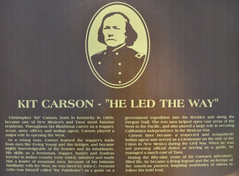
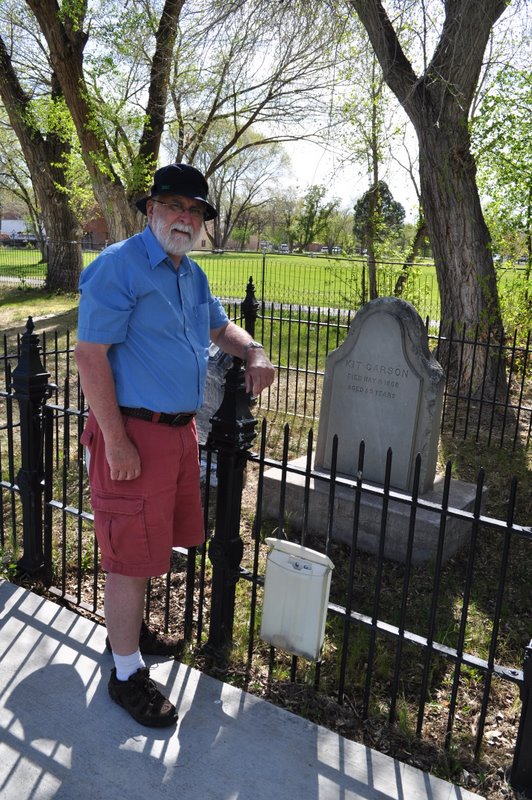
Well, in early 2011 I came across a book in the public library in Bromsgrove (in Worcestershire where I used to live) about US army officer, Indian fighter, explorer and adventurer, Colonel Christopher Houston ‘Kit’ Carson (1809-1868). Kit Carson was a western ‘hero’ of my boyhood, a figure in popular western culture and myth.

In 1863, he led an expedition into Canyon de Chelly to vanquish the resident Navajo tribe, killing more than 20 persons, stealing 200 or more sheep, destroying their homes (known as hogans) and their precious peach orchards. Not something to be proud of or remembered for as a hero. Anyway, this biography of Carson had me intrigued, and as I began to plan our road trip to the American Southwest for May, I decided to see if it would be possible to include Canyon de Chelly in the itinerary. It fitted in just right.

Landing in Phoenix, we headed north through Sedona Valley to Flagstaff, and on to the Grand Canyon the next day via Sunset Crater Volcano National Monument and Wupatki National Monument. After a couple of nights at the Grand Canyon, we headed east to Chinle (the nearest town to Canyon de Chelly) via Monument Valley.


The Canyon de Chelly National Monument actually comprises three interconnected canyons: Chelly, del Muerto, and Monument. It was designated a national monument in 1931. It’s the ancestral home of the Navajo, but throughout there are the relics of Ancestral Pueblans or Anasazi built into the cliff faces.

Access to the floor of the canyon is limited, with just one trail—to the White House—open to the public (although currently closed due to safety and ‘law enforcement’ issues). Otherwise, visitors must take one of the guided tours to travel along the canyons.

However, there are rim drives on the north and south sides of the canyon, with several overlooks providing spectacular (awe-inspiring even) views. Steph and I set out early from our motel, before the day became too hot, to explore as much as possible along both rim drives.

The approach to Canyon de Chelly from Chinle is not particularly impressive. In the canyon bottom there are groves are cottonwoods springing up beside the creeks that run through.

But it’s not until you begin to climb further along the rim drives that the true nature of Canyon de Chelly reveals itself, with sheer sandstone cliffs rising from the canyon floor.

In places these cliffs are 700 feet or more high.

Among the impressive Ancient Pueblan ruins are Mummy Cave and Antelope House (seen from the north rim drive), and the White House from the south.

Mummy Cave

Antelope House

White House

There is also a cave, fairly close to the rim on the north side known as Massacre Cave where, in 1825, the Navajo were slaughtered by invading Spanish troops.

Massacre Cave

The drive along the south rim eventually brings you to the Spider Rock overlook. Spider Rock is a free-standing sandstone pillar, over 700 feet tall, named after Spider Woman, a prominent character in Navajo lore.

Spider Rock, with the Chuska Mountains on the Arizona-New Mexico border on the horizon.

There were few people visiting at the same time as us, and it felt as though we had the whole canyon to ourselves. While we didn’t descend to the canyon floor, the overlook points along both the north and south rim drives provide excellent visual access to the canyon from above.

Spider Rock overlook

Now I’d like to return, taking several days to really explore, understand better the Navajo relationship with Canyon de Chelly, how they came to occupy it, and how their agriculture has evolved over the centuries. In fact, I’d like to understand more about the evolution of human societies in the American southwest.

The grave of Col. ‘Kit’ Carson in Taos cemetery, New Mexico.

Canyon de Chelly has featured in at least 26 movies or TV specials, among the most notable being The Lone Ranger (2013) with Johnny Depp, Wild Wild West (1999) with Will Smith, Kenneth Branagh, and Kevin Kline, Mackenna’s Gold (1969) with Gregory Peck and Omar Sharif, How The West Was Won (1962) with a host of ‘Western’ stars, and The Big Country (1958) with Gregory Peck, Jean Simmons, and Charlton Heston.

Heading east from Arizona, we found ourselves in Taos in northern New Mexico where I visited the grave of Kit Carson.

If you ever find yourself on the border of Arizona and New Mexico, make a beeline for Canyon de Chelly. You won’t regret it.

Discovering pre-Columbian humanity in the Americas

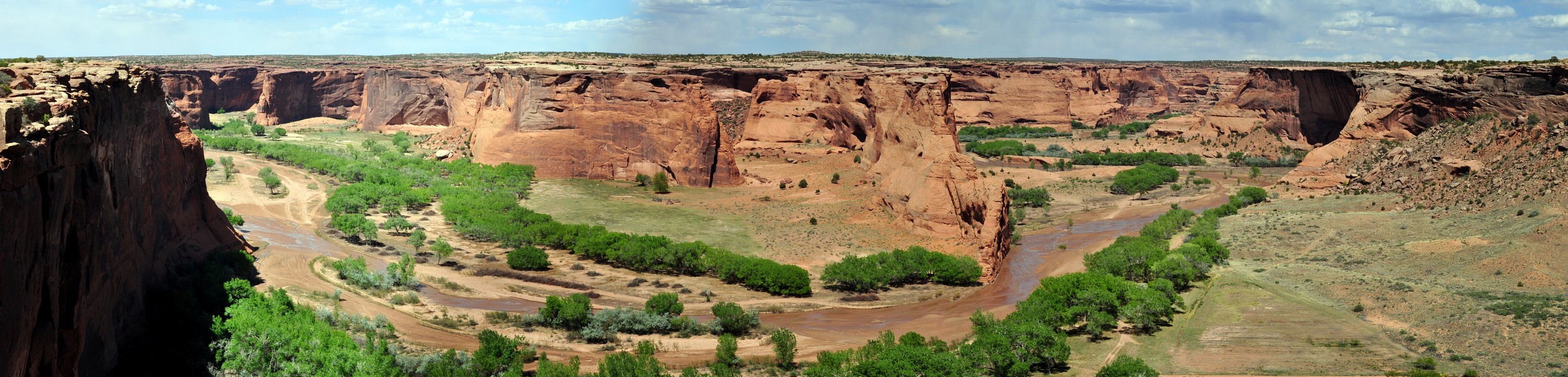
Over recent weeks, Steph and I have been enjoying the latest series of Digging for Britain on BBC2, hosted by Alice Roberts who is Professor of Public Engagement in Science at the University of Birmingham. In this ninth series (as in the earlier programs) she visited digs all over the UK where archaeologists were busy uncovering our distant (and not-so-distant) past, and the lives of the people who lived there.

In one program she visited a (secret) site in Rutland (England’s smallest county in the East Midlands) where, in a farmer’s field, the most remarkable Roman mosaic floor had been uncovered, depicting scenes from the Trojan War. This was only one of many treasures that were ‘discovered’ during the series.

The British landscape has been transformed by multiple waves of immigration and conquest over thousands of years. But scrape away the surface, as archaeologists are wont to do, and fascinating histories begin to emerge, from prehistoric times through to the arrival of the Romans in AD 43, and in the centuries afterwards.

Sites like Stonehenge or the Avebury Stone Circle remind us that humans were living in and modifying these landscapes thousands of years before the Romans arrived on these shores.

Avebury Stone Circle.

Northumberland in the northeast of England (where I now live) is particularly rich in Roman remains. Besides the iconic Hadrian’s Wall, forts like Housesteads or Chew Green, and towns like Corbridge and Vindolanda are a visible reminder that these islands were once under the military control of an empire the like of which the world had never seen before. Northumberland was the northwest frontier.

And after the Romans departed in the 5th century AD, northern tribes such as by Angles, Saxons, and Jutes from continental Europe made these islands their home.

However, I often view our landscape as essentially post-Norman (that is, after 1066) since the Normans (and their descendants) left so many statements of their hegemony: magnificent castles (such as Prudhoe, Warkworth, and Dunstanburgh that stand as proud ruins even today), manor houses, churches and abbeys, and royal hunting parks.


I guess our appetite for the archaeological past was whetted when we moved to Peru in 1973. Within two weeks of landing in Lima in January I had already visited Machu Picchu while attending a meeting in Cuzco. Then, after Steph arrived in Lima in July, we spent many weekends exploring the coast and heading off into the numerous valleys that lead inland from Lima. In December, I took her to Machu Picchu (for a delayed honeymoon!)

Over the three years we spent in Peru, five in Central America, and more recently in the southwestern United States, we have visited a number of iconic pre-Columbian archaeological sites, and others less well known.

It’s not just the remains that various cultures have left behind, however. It’s also understanding their connection with the environment, the types of agriculture practiced for example, and the crops that were domesticated and brought into cultivation (a particular interest of mine).

So permit me to take you on a brief archaeological travelogue through the Americas.


Hiram Bingham III

As I’ve already mentioned Machu Picchu, perhaps I should start there. I guess it’s not only the location of this Incan refuge, but something of the mystery that surrounds it until it was ‘discovered’ by Hiram Bingham III in 1911 (although there are earlier claimants).

But tales of a lost city in Peru certainly caught the public imagination, and soon Machu Picchu was a notable tourist destination. In 1973, the rail journey between Cuzco and Machu Picchu was slow and left early in the morning. Nowadays the line has been upgraded and beside the river (way below the ruins) a small town has sprung up to accommodate the multitude of tourists who descend on Machu Picchu daily from all over the world.

I made just a day visit there in January 1973. However, Steph and I were lucky to reserve a room at the turista hotel that once stood just outside the ruins. So, once most tourists had returned to Cuzco late in the afternoon, we (and a handful of other hotel guests) had the ruins to ourselves. Next morning we breakfasted early to watch the sun rise, and enjoy the peace and quiet of this iconic site until, late morning, it was thronging once again with a trainload of tourists.

In many ways it’s not surprising that Machu Picchu remained ‘undiscovered’ for so long, five centuries after the last Inca took refuge there. Other ruins, further out into the jungle, have been uncovered in recent years, like Choquequirao, a two day hike from Cuzco.


What is remarkable about Cuzco, the Inca capital before the Spaniards arrived in the 16th century, is the juxtaposition of Incan and colonial architecture, in many places the latter built over the former. The beautiful Incan stonework is epitomized, for example, in the 12-sided stone in Calle Jatun Rumiyoc, east of the Plaza de Armas (the city’s main square).

Or the foundations of the Qorikancha temple (right) on which the colonizing Spaniards built the Santo Domingo convent five centuries ago.

Outside and overlooking Cuzco from the north is the impressive Inca fortress Sacsayhuamán (below). It’s not only its size, but especially the precision with which the stones have been placed together, some stones (like that shown below) weighing tens of tons at the very least.

Just 32 km to the northeast of Cuzco, and standing at the head of the Sacred Valley of the Incas is the market town of Pisac. Even in 1973 it was a major tourist attraction, even though it had changed little from almost 40 years previously when my PhD supervisor Professor Jack Hawkes had visited as a young man of 24. Check out these photos I took in 1973, and compare them with scenes in the film that Jack made in 1939 (after minute 25:25).

Above the town, 15th century terraces or andenes stretch up the hillside, where there are also temple remains; due to limited time we didn’t have an opportunity of exploring those nor travel further down the valley to Ollantaytambo where there are also impressive Inca remains.

Andenes above the town of Pisac.

But what is particularly remarkable about the Incas is the relative short period (perhaps a little over 300 years until the Spanish conquest in the mid-16th century) in which they held domain over many of the other cultures that had gone before them. Not only in the mountains, but on the coast as well, as I shall describe a little later.


But talking of terraces, I was fortunate to visit the small town of Cuyo Cuyo in Puno in the far south of Peru, in February 1974 while undertaking some fieldwork for my PhD research. Agricultural terraces built centuries ago are still being farmed communally today (at least when I visited almost 50 years ago).

Potato terraces at Cuyo Cuyo, Puno in southern Peru.

While some terraces had fallen into disrepair, the majority were still being carefully tended, and planted with a rotation of potatoes-oca (a minor Andean tuber crop)-barley or beans-fallow over about an eight year period. Impressive as they are, terraces like those at Cuyo Cuyo can be seen in many valleys all over Peru, but perhaps not so actively farmed as there.


Puno is one of the highest cities in the world, at just over 3800 m (12,556 ft), alongside Lake Titicaca, the highest navigable lake.

On a peninsula overlooking a lake about 33 km northwest of Puno stands a cluster of rather peculiar round towers, known as chullpas, of the most exquisite masonry, mostly ruined. Some of these stand 12 m tall. This is Sillustani, a pre-Incan Aymara cemetery site.

It seems that once this area came under Inca control, many of the chullpas were redressed with Incan masonry, much of what we see today.


One could be forgiven for imagining that the coastal desert of Peru is one huge cemetery, such is the extent of the burial sites where Moche (AD 100 -AD 800) and Chimú civilizations (AD 900 until about AD 1470 when the Incas arrived on the scene), and others, held sway leaving behind a vast array of artefacts that tell us so much about them. Having no written language, their pottery tells us much about the crops they grew, the animals they kept, even their sex lives.

Mummy bundles have been excavated in their thousands, and many of the contents are now carefully stored in one of Lima’s most prestigious museums, with just a fraction on display at any one time. Take a moment to read about the museum and its contents that I published in 2017.

All along the coast there are temples built of mud bricks, like the one below. I don’t remember exactly where this was located, but I think maybe in one of the valleys inland from the coast, 4-500 km north of Lima.

One of the more important ones lies just 40 km (or 25 miles) south of Lima. Pachacamac covers about 240 hectares, and was continuously occupied from about AD 100 until the Spanish conquest, 1300 years later.

North of Lima there are two interesting sites.

Just outside the coastal city of Casma (about 350 km or 165 miles north of Lima) stand the unusual remains of Cerro Sechín, an archaeological complex covering many hectares, and one of the oldest sites in Peru, dating back about 4000 years. The striking elements of this site are the bas-reliefs etched into the stonework depicting war-like scenes, of warriors, mutilation and the like. It really is a most unusual site. Steph and I visited there (with our CIP friends John and Marian Vessey) in 1974.

At Sechín, as at other coastal sites, the archaeological evidence shows that not only did the inhabitants practice agriculture (maize and beans being the domesticated staples) but depended on the abundant marine resources close by.

Further north, outside the city of Trujillo stand the degraded remains of Chan Chan, once the great Chimú capital covering 20 km², and built of adobe bricks. It’s regarded as the largest adobe-built city in the world. The complex comprises plazas and citadels, and because of the extremely arid conditions, many of the walls (and their carvings of animals, birds and marine life) have survived to the present.

While the coastal desert is one of the driest in the world, it does rain heavily from time-to-time, and when we visited the walls were being protected from further rain erosion.

Unfortunately, I never got to view the world-famous Nazca Lines from the air. As you cross the Nazca plain (over 400 km south of Lima) you can see some of the lines stretching into the distance but with no comprehension of what they might represent. Furthermore, indiscriminate vehicular access to this area in the past (even army manoeuvres!) has left indelible tracks across the desert, desecrating some of the incredible figures there.

The Nazca Plain from the Panamericana Sur. You can see vehicle tracks heading off into the desert.

The monkey on the Nazca lines.


On the southeastern side of the Cordillera Blanca in the Department of Ancash the ruins at Chavín de Huántar, a site that was occupied over 3000 years ago, and regarded as the oldest highland culture in Peru.

‘El Castillo’ at Chavín de Huántar.

A stone head or tenon at Chavín de Huántar.

I visited there in May 1973 when collecting potatoes in that part of Peru, and again with Steph and the Vesseys a year later.

Just outside the highland city of Cajamarca (2750 m, about 180 km inland from the coast between Trujillo and Chiclayo) are the Ventanillas de Otuzco, and ancient necropolis (over 2000 years old) carved in the rock face.


Steph and I lived in Costa Rica in Central America for almost five years from April 1976. There are few remains of indigenous cultures around the country (unlike Guatemala or Mexico for instance).

However, just under 20 km north of Turrialba (where we lived) lie the enigmatic remains of Guayabo National Monument, which I wrote about in October 2017.

There’s good evidence however that this site was first occupied over 2000 years ago, until the beginning of 15th century.

In the jungle of northeast Guatemala stands the ruins of ancient Tikal, a Mayan complex dating back more than 2400 years, surely one of the most iconic archaeological sites on the planet (and which even featured in the very first Star Wars movie).

Steph and I flew there in 1977, on an Aviateca DC3, spending one night in one of the lodges. Back in the day it was possible to reach Tikal only by air, but the whole region has now opened up via roads and even an international airport in the nearby city of Flores, just 64 km to the south. I guess the site must now be overrun to some extent by tourists, much like has happened at Machu Picchu. We were fortunate to visit here, as with many of the sites I have described, before they appeared on the everyday tourist routes.

We spent hours wandering around this huge site, and managing to see just a fraction probably. It’s hard to imagine just how steep the temple steps are. No wonder Steph was out of breath. We later learned that she was pregnant when we were there.

It seems that Tikal was conquered, around the 4th century AD, from Teotihuacán from the valley of Mexico. And it’s there, north of present day Mexico City that the important temple complex of Teotihuacán can be found. Its famous Temple of the Sun and others are significant Mesoamerican pyramids standing on a site that covers 21 km². We visited there in April 1975 on our way back to the UK, staying with our friends John and Marian Vessey who had left CIP to join a sister research center, the International Maize and Wheat Improvement Center (CIMMYT) that is located not far from Teotihuacán. I’ve been back there a couple of times in the 1990s and 2000s.


Our elder daughter Hannah moved to Minnesota in 1998 to complete her undergraduate degree at Macalester College in St Paul, then registered at the University of Minnesota for her PhD in psychology. In 2006 she married Michael, and they set up home in St Paul. Grandchildren Callum and Zoë came along in 2010 and 2012, respectively. And since I retired from IRRI in 2010 and returned to the UK, Steph and I have visited them every year, and made some pretty impressive road trips across many parts of the USA. That is until Covid 19 put paid to international travel for the time being.

In 2011, we had the opportunity of fulfilling a lifetime ambition: to travel to the Grand Canyon in Arizona. So we flew from Minneapolis-St Paul (MSP) to Phoenix (PHX) to take in the Grand Canyon, and travel extensively through Arizona and New Mexico. We visited three sites on this trip, but only one, the Canyon de Chelly, was a pre-trip destination. We fortunately came across the other two during the course of our travels.

We stopped in Flagstaff on our first night, having traveled north from Phoenix through the Sedona valley and having our first taste of the magnificent red-rock buttes. Then, the following day as we headed north on US89, we saw a sign to Sunset Crater Volcano National Monument.

Checking the map, I saw that we could make a useful diversion, and also taking in further north Wupatki National Monument, a 100-room pueblo and other buildings in the surrounding small ‘canyons’. It is believed that peoples first gathered here around 1100 AD, just a century after the Sunset Crater Volcano erupted. Even today, Wupatki is revered by the Hopi, Zuni, and Navajo tribes.

After a couple of nights at the Grand Canyon (South Rim), and a detour to Monument Valley we found ourselves in Chinle, in northeast Arizona.

In the heart of the Navajo Nation, Chinle is the gateway to the Canyon de Chelly National Monument. Occupied for thousands of years, Canyon de Chelly is a very special place, and somewhere in the USA that I would return to tomorrow, given half the chance.

It was settled by ancient Puebloans at least 4000 years ago, finding the steep-sided canyon an ideal place to settle, raise their families in a safe environment, and raise their crops. These included, after the Spanish arrival in the Americas in the 16th century, peaches that were destroyed during reprisal raids by the US Army in the late 19th century, led by Indian agent and Army officer Kit Carson. In fact, it was reading a biography of Kit Carson in February 2011 that was the impetus to visit Canyon de Chelly.

We viewed the canyon from the rim only. Access to the canyon floor is limited to just one access point to visitors on foot, who can climb the long way down (800-1000 feet) to view houses built into the cliff face. We could see that from the rim, as well as two others at different locations and at different heights on the canyon wall. The Navajo must have felt they were safe from invaders, but unfortunately not, making a last stand at the tall pillar Spider Rock that you can see in one of the images below.

The Navajo do provide guided tours into the canyon, and if I ever return, I’ll spend several days there and take the tour.

On the penultimate day of our road trip, passing through Los Alamos (where the first atom bombs were designed) in New Mexico, we’d seen signposts to Bandelier National Monument. There’s good evidence of human settlement in this area over 10,000 years ago; ancestral Puebloan peoples settled here 2000 years ago, but had moved on by the mid-16th century.

Rooms were carved into the soft rock or tuff, with ladders used to scale the cliff face. In a few places rock art can be seen. There is also good evidence of agriculture based on the staple triumvirate of maize, beans, and squashes, as well as hunting for deer. Since we had to make progress towards Albuquerque for the last night before flying back to MSP, we were not able to spend as much time exploring the site as we wanted.

Nevertheless, with our visits to Wupatki, Canyon de Chelly, and Bandelier, we gained an appreciation of ancient lives in these desert environments. Of course there’s more to see and learn about the Chaco culture that thrived in New Mexico. Ancient settlements are scattered all over Arizona, New Mexico, and Colorado.