In the footsteps of the Ancestral Puebloans

Over the past 14 years, Steph and I have made several awesome road trips across the USA, covering 36 states and visiting many national parks and national monuments. I can’t decide which trip I enjoyed most, but the two we made to the American Southwest stand out for the amazing desert landscapes and the fascinating archaeology there.

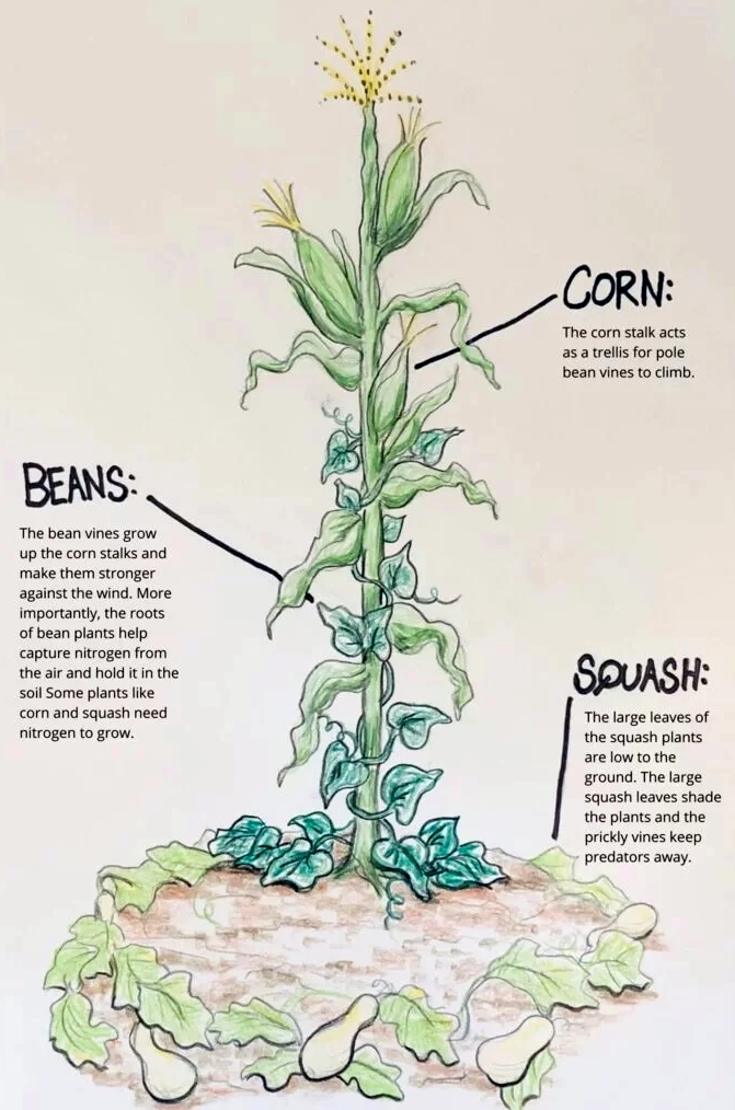
The ‘three-sisters’ of indigenous American agriculture.

The Ancestral Puebloans (formerly known as the Anasazi) inhabited the southwest in a region known as the Four Corners (where Arizona, New Mexico, Colorado, and Utah meet) from about 500 CE and were known for their pit houses, and cliff dwellings constructed in alcoves along the walls of sandstone canyons.

Where did these people come from, who taught them subsistence agriculture (based on the ‘three sisters‘ polyculture of corn, beans, and squashes), and why did they abandon many of their settlements around 1300 CE?

Since corn (Zea mays) was domesticated in southern Mexico, thousands of years earlier, the Ancestral Puebloans must have had links with other peoples to the south with whom they traded.

I’m still trying to understand North American indigenous cultures, so I’m not going to make any attempt here to explain the Ancestral Puebloans as such. But I have included links where you can find more information.


In 2011, we spent about 10 days exploring Arizona and New Mexico. This past May, over seven days, we drove from Las Vegas, NV to Denver, CO across Utah.

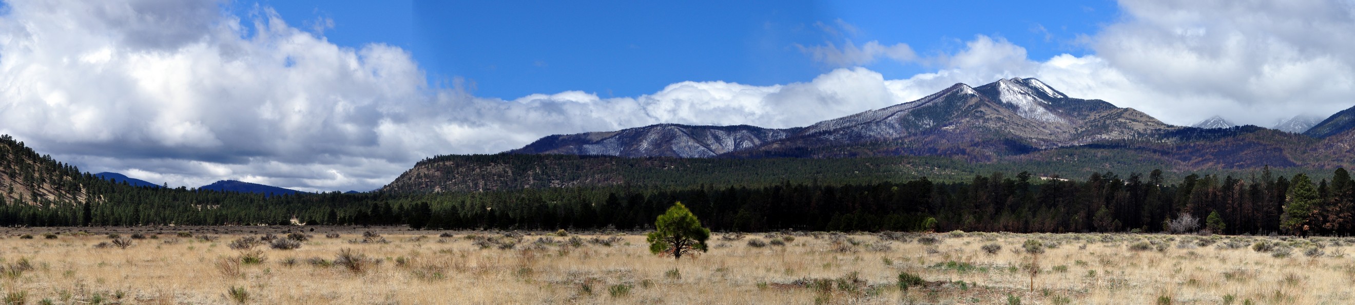
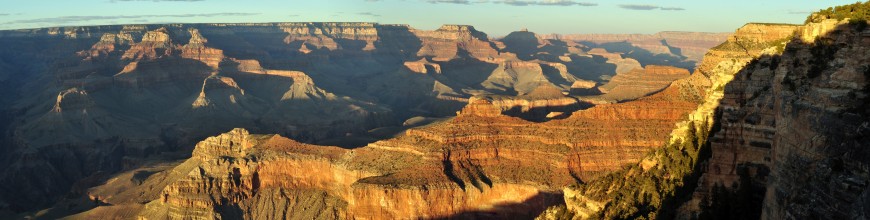
We first came across Ancestral Pueblo settlements on that 2011 trip when, heading north from Flagstaff, AZ to the Grand Canyon, we took a diversion east and visited Wupatki National Monument, and three different sites there: Wukoki Pueblo, Wupatki Pueblo, and Box Canyon. It was a bustling community at its zenith in the 12th century CE, but had been largely abandoned by the first quarter of the 13th.

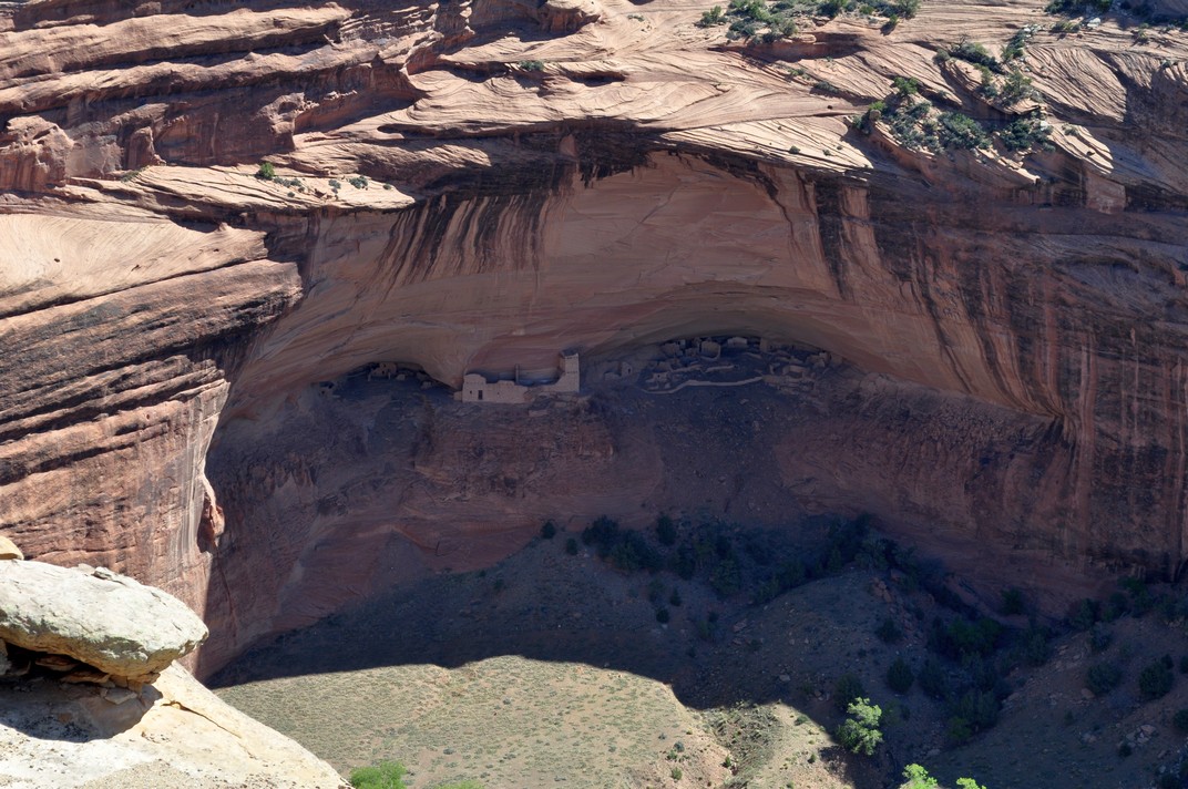
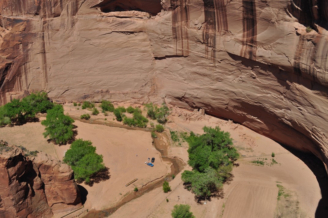
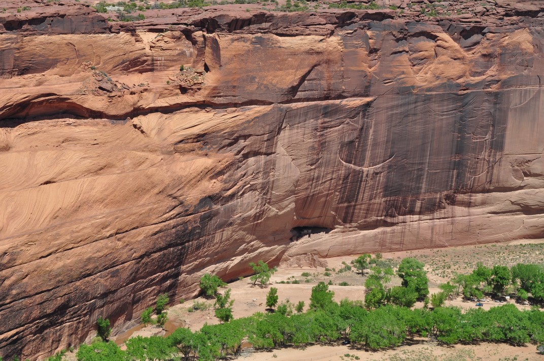
Then it was on to Canyon de Chelly National Monument in northeast Arizona. We viewed three settlements from the rim of the canyon. Mummy Cave, high on the canyon wall (upper image below), was occupied for a thousand years from about 300 CE, so I have read. Antelope House (middle image), and another, White House ruin (lower image, built in the early 11th century CE), nearer the canyon floor, and the only ruin accessible (from the canyon rim) to tourists on foot. Other visits to the canyon have to be organized with local Navajo tour guides.

On that same trip we drove into New Mexico, passing nearby but not visiting two World Heritage sites: Chaco Culture National Historical Park, a major center of Ancestral Puebloan culture dating between 850 and 1250 CE, and Taos Pueblo, home to Native Americans for over a thousand years. Near Los Alamos, we did visit Bandelier National Monument, a site dated to a later Ancestral Puebloan era, from around 1150 CE to 1600 CE, with rooms carved into the cliff face.


This year, however, Mesa Verde National Park in southwest Colorado (some 35 miles west of Durango) was very much on our itinerary. Ancestral Puebloan remains there span the whole 750 year occupation from about 550 CE up until c. 1300 CE.

The route I’d planned south to Durango took us from Grand Junction in northwest Colorado over the Million Dollar Highway, a 25 mile section of US 550 between Ouray and Silverton in the San Juan Mountains. I had expected the 165 mile drive to take all day, and had planned accordingly, since the Million Dollar Highway is claimed to be one of the most challenging—and dangerous—highways in the USA. In many places there are no guard rails. You can view the route in a couple of videos here. Just scroll down to ‘Day 5’.

However, it took only half a day, so we decided to head to Mesa Verde that same afternoon rather than waiting for the next morning. I guess we must have arrived at the Visitor Center by about 3 pm. Like our visit to Bryce Canyon a few days earlier, arriving mid-afternoon was really quite fortuitous. Many visitors were already leaving and none of the parking lots at the various sites along the park drive was busy, making for a tranquil appreciation of all the park had to offer. And, as an added bonus, visiting Mesa Verde that afternoon freed up time the next day for the 260 mile drive east to Cañon City.

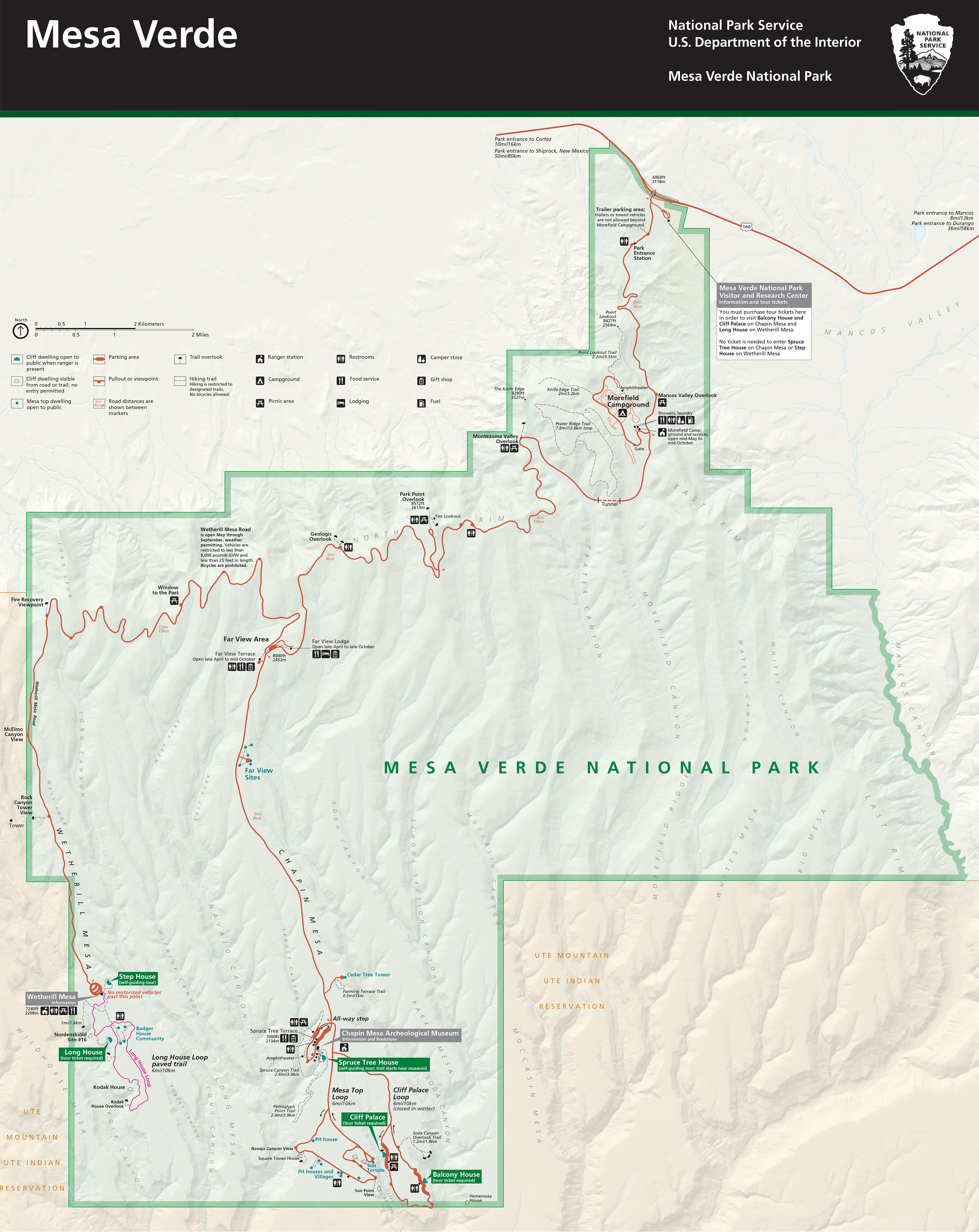
From the Visitor Center it’s a 23 mile drive to the southernmost point on the Mesa Top Loop where some of the most complete ruins are located. The park has 5000 known archaeological sites, and over 600 cliff dwellings. Although famous for its cliff dwellings, these were occupied for a short period, not long before the people abandoned Mesa Verde for reasons not fully understood, and moved south. Click on the map below to open an enlarged version.

The park road climbs steeply on to the mesa top, which lies around 7-8000 ft above sea level. So, in summer it’s blisteringly hot, and bitingly cold in winter. No wonder it was a challenge to live here.

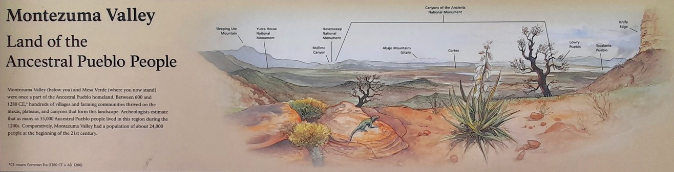
On the way south, one of our first stops was the Montezuma Valley Overlook, from where there is an impressive view of the landscape west into Utah. Click on this image to open a larger version.

I recently came across the video below, posted by explorer and YouTuber Andrew Cross (Desert Drifter – more later). On a recent visit to southeast Utah in Montezuma Canyon, a group from The Archaeological Conservancy explored the extensive settlements there.

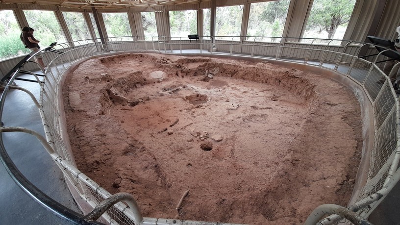
The first Ancestral Puebloans lived in pit houses on the mesa tops, and constructed partially underground. The earliest date from the 6th century CE.

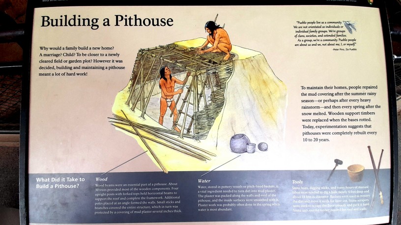
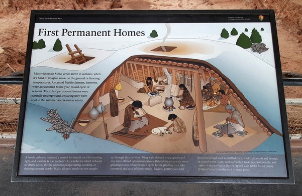
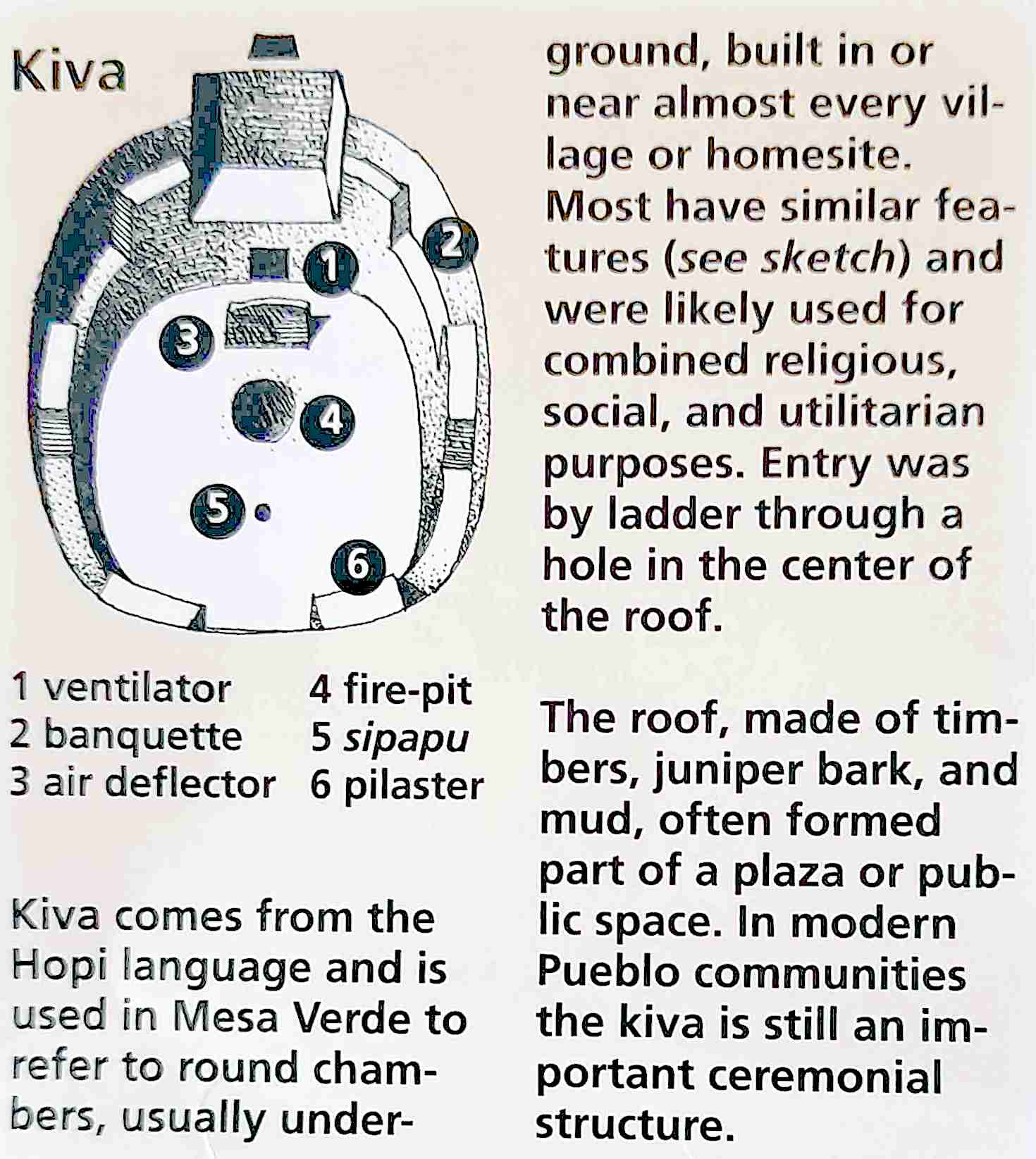
Then, several centuries later, larger villages were established (like those we saw at Wupatki) but also the cliff dwellings comprised of multiple houses and rooms, and round, ceremonial courtyards known as kivas, and which can also be seen in the Bandelier images above.

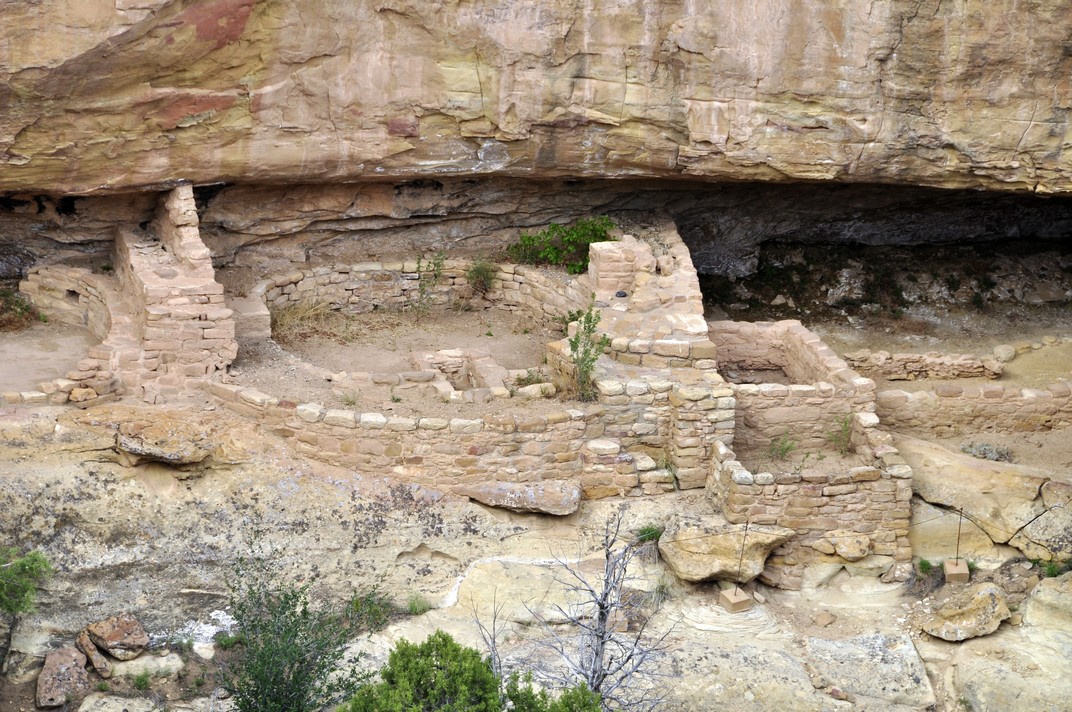
Two of the sites on the Mesa Top Loop, the Cliff Palace and Balcony House are only accessible on a guided tour, which we didn’t take. In any case, access to both requires scrambling up ladders, which I would not have managed (I’m currently using a stick due to an on-going back problem). The Cliff Palace and several other buildings close by can be viewed from an overlook. All very impressive.

The Ancestral Puebloans gained access to the cliff dwellings through handholds in the rock face, or using ropes. Certainly their difficult accessibility must have been a key feature for defence.

So, from the original sparsely settled villages of pit houses, to the more densely populated cliff dwellings, it’s estimated that Mesa Verde was once home to thousands of families. But by about 1300 CE they had upped sticks and moved on. Why? No-one really knows but it could have been due to drought affecting agricultural productivity. Or maybe conflicts had broken out, thus the reasons for more defensive villages in the cliff dwellings. The Ancestral Puebloans certainly left a strong legacy behind.


Earlier I mentioned Andrew Cross (right) and his Desert Drifter channel. It’s certainly worth a watch. His videos document his backpacking trips into canyon country looking for signs of the Ancestral Puebloans (and other indigenous peoples) that he has discovered through careful study of Google Earth images.

And he has come across some remarkable settlements, often sufficient to support just one or two families at most, who left behind evidence of their occupancy 1000 years ago in the form of pottery shards (typically black stripes on a white background), arrow heads, various tools for grinding corn, and ancient corn cobs as well. And the Puebloans also left behind incredible pictographs (paintings) and petroglyphs (etched into the rock surface) of fantastical humans, animals, and symbols. Hand prints are common everywhere.


The day after visiting Mesa Verde, we set off early from Durango to cross the mountains east of Pagosa Springs, before heading northeast to Cañon City.

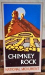
About 16 miles short of Pagosa Springs we saw a road sign to Chimney Rock National Monument, which was just under 4 miles south from the main highway, US 160. I hadn’t noticed this when planning the trip, but as we now had extra time, we decided to explore. We were not disappointed.

Chimney Rock, an outlier from the Chaco Canyon Regional system, ‘. . . covers seven square miles and preserves 200 ancient homes and ceremonial buildings, some of which have been excavated for viewing and exploration: a Great Kiva, a Pit House, a Multi-Family Dwelling, and a Chacoan-style Great House Pueblo. Chimney Rock is the highest in elevation of all the Chacoan sites, at about 7,000 feet above sea level.’

From the Visitor Center, it’s a a 2½ mile drive, on a gravel road, to a parking lot just below the summit of the mesa, and the ruins there. From the parking lot, it’s a steady climb over about a quarter of mile to reach the summit, at 7620 feet.

The panorama there takes in the Rockies to the east, and southwest into New Mexico towards Chaco Canyon, about 90 miles away.

You can view my Chimney Rock photo album here.


Our visits to these extraordinary sites have, for me, generated more questions than answers. I need to spend some time researching human expansion across North America over the millennia. And the story of how agriculture developed in this region of the Four Corners continues to fascinate me.

Discovering pre-Columbian humanity in the Americas

Over recent weeks, Steph and I have been enjoying the latest series of Digging for Britain on BBC2, hosted by Alice Roberts who is Professor of Public Engagement in Science at the University of Birmingham. In this ninth series (as in the earlier programs) she visited digs all over the UK where archaeologists were busy uncovering our distant (and not-so-distant) past, and the lives of the people who lived there.

In one program she visited a (secret) site in Rutland (England’s smallest county in the East Midlands) where, in a farmer’s field, the most remarkable Roman mosaic floor had been uncovered, depicting scenes from the Trojan War. This was only one of many treasures that were ‘discovered’ during the series.

The British landscape has been transformed by multiple waves of immigration and conquest over thousands of years. But scrape away the surface, as archaeologists are wont to do, and fascinating histories begin to emerge, from prehistoric times through to the arrival of the Romans in AD 43, and in the centuries afterwards.

Sites like Stonehenge or the Avebury Stone Circle remind us that humans were living in and modifying these landscapes thousands of years before the Romans arrived on these shores.

Avebury Stone Circle.

Northumberland in the northeast of England (where I now live) is particularly rich in Roman remains. Besides the iconic Hadrian’s Wall, forts like Housesteads or Chew Green, and towns like Corbridge and Vindolanda are a visible reminder that these islands were once under the military control of an empire the like of which the world had never seen before. Northumberland was the northwest frontier.

And after the Romans departed in the 5th century AD, northern tribes such as by Angles, Saxons, and Jutes from continental Europe made these islands their home.

However, I often view our landscape as essentially post-Norman (that is, after 1066) since the Normans (and their descendants) left so many statements of their hegemony: magnificent castles (such as Prudhoe, Warkworth, and Dunstanburgh that stand as proud ruins even today), manor houses, churches and abbeys, and royal hunting parks.


I guess our appetite for the archaeological past was whetted when we moved to Peru in 1973. Within two weeks of landing in Lima in January I had already visited Machu Picchu while attending a meeting in Cuzco. Then, after Steph arrived in Lima in July, we spent many weekends exploring the coast and heading off into the numerous valleys that lead inland from Lima. In December, I took her to Machu Picchu (for a delayed honeymoon!)

Over the three years we spent in Peru, five in Central America, and more recently in the southwestern United States, we have visited a number of iconic pre-Columbian archaeological sites, and others less well known.

It’s not just the remains that various cultures have left behind, however. It’s also understanding their connection with the environment, the types of agriculture practiced for example, and the crops that were domesticated and brought into cultivation (a particular interest of mine).

So permit me to take you on a brief archaeological travelogue through the Americas.


Hiram Bingham III

As I’ve already mentioned Machu Picchu, perhaps I should start there. I guess it’s not only the location of this Incan refuge, but something of the mystery that surrounds it until it was ‘discovered’ by Hiram Bingham III in 1911 (although there are earlier claimants).

But tales of a lost city in Peru certainly caught the public imagination, and soon Machu Picchu was a notable tourist destination. In 1973, the rail journey between Cuzco and Machu Picchu was slow and left early in the morning. Nowadays the line has been upgraded and beside the river (way below the ruins) a small town has sprung up to accommodate the multitude of tourists who descend on Machu Picchu daily from all over the world.

I made just a day visit there in January 1973. However, Steph and I were lucky to reserve a room at the turista hotel that once stood just outside the ruins. So, once most tourists had returned to Cuzco late in the afternoon, we (and a handful of other hotel guests) had the ruins to ourselves. Next morning we breakfasted early to watch the sun rise, and enjoy the peace and quiet of this iconic site until, late morning, it was thronging once again with a trainload of tourists.

In many ways it’s not surprising that Machu Picchu remained ‘undiscovered’ for so long, five centuries after the last Inca took refuge there. Other ruins, further out into the jungle, have been uncovered in recent years, like Choquequirao, a two day hike from Cuzco.


What is remarkable about Cuzco, the Inca capital before the Spaniards arrived in the 16th century, is the juxtaposition of Incan and colonial architecture, in many places the latter built over the former. The beautiful Incan stonework is epitomized, for example, in the 12-sided stone in Calle Jatun Rumiyoc, east of the Plaza de Armas (the city’s main square).

Or the foundations of the Qorikancha temple (right) on which the colonizing Spaniards built the Santo Domingo convent five centuries ago.

Outside and overlooking Cuzco from the north is the impressive Inca fortress Sacsayhuamán (below). It’s not only its size, but especially the precision with which the stones have been placed together, some stones (like that shown below) weighing tens of tons at the very least.

Just 32 km to the northeast of Cuzco, and standing at the head of the Sacred Valley of the Incas is the market town of Pisac. Even in 1973 it was a major tourist attraction, even though it had changed little from almost 40 years previously when my PhD supervisor Professor Jack Hawkes had visited as a young man of 24. Check out these photos I took in 1973, and compare them with scenes in the film that Jack made in 1939 (after minute 25:25).

Above the town, 15th century terraces or andenes stretch up the hillside, where there are also temple remains; due to limited time we didn’t have an opportunity of exploring those nor travel further down the valley to Ollantaytambo where there are also impressive Inca remains.

Andenes above the town of Pisac.

But what is particularly remarkable about the Incas is the relative short period (perhaps a little over 300 years until the Spanish conquest in the mid-16th century) in which they held domain over many of the other cultures that had gone before them. Not only in the mountains, but on the coast as well, as I shall describe a little later.


But talking of terraces, I was fortunate to visit the small town of Cuyo Cuyo in Puno in the far south of Peru, in February 1974 while undertaking some fieldwork for my PhD research. Agricultural terraces built centuries ago are still being farmed communally today (at least when I visited almost 50 years ago).

Potato terraces at Cuyo Cuyo, Puno in southern Peru.

While some terraces had fallen into disrepair, the majority were still being carefully tended, and planted with a rotation of potatoes-oca (a minor Andean tuber crop)-barley or beans-fallow over about an eight year period. Impressive as they are, terraces like those at Cuyo Cuyo can be seen in many valleys all over Peru, but perhaps not so actively farmed as there.


Puno is one of the highest cities in the world, at just over 3800 m (12,556 ft), alongside Lake Titicaca, the highest navigable lake.

On a peninsula overlooking a lake about 33 km northwest of Puno stands a cluster of rather peculiar round towers, known as chullpas, of the most exquisite masonry, mostly ruined. Some of these stand 12 m tall. This is Sillustani, a pre-Incan Aymara cemetery site.

It seems that once this area came under Inca control, many of the chullpas were redressed with Incan masonry, much of what we see today.


One could be forgiven for imagining that the coastal desert of Peru is one huge cemetery, such is the extent of the burial sites where Moche (AD 100 -AD 800) and Chimú civilizations (AD 900 until about AD 1470 when the Incas arrived on the scene), and others, held sway leaving behind a vast array of artefacts that tell us so much about them. Having no written language, their pottery tells us much about the crops they grew, the animals they kept, even their sex lives.

Mummy bundles have been excavated in their thousands, and many of the contents are now carefully stored in one of Lima’s most prestigious museums, with just a fraction on display at any one time. Take a moment to read about the museum and its contents that I published in 2017.

All along the coast there are temples built of mud bricks, like the one below. I don’t remember exactly where this was located, but I think maybe in one of the valleys inland from the coast, 4-500 km north of Lima.

One of the more important ones lies just 40 km (or 25 miles) south of Lima. Pachacamac covers about 240 hectares, and was continuously occupied from about AD 100 until the Spanish conquest, 1300 years later.

North of Lima there are two interesting sites.

Just outside the coastal city of Casma (about 350 km or 165 miles north of Lima) stand the unusual remains of Cerro Sechín, an archaeological complex covering many hectares, and one of the oldest sites in Peru, dating back about 4000 years. The striking elements of this site are the bas-reliefs etched into the stonework depicting war-like scenes, of warriors, mutilation and the like. It really is a most unusual site. Steph and I visited there (with our CIP friends John and Marian Vessey) in 1974.

At Sechín, as at other coastal sites, the archaeological evidence shows that not only did the inhabitants practice agriculture (maize and beans being the domesticated staples) but depended on the abundant marine resources close by.

Further north, outside the city of Trujillo stand the degraded remains of Chan Chan, once the great Chimú capital covering 20 km², and built of adobe bricks. It’s regarded as the largest adobe-built city in the world. The complex comprises plazas and citadels, and because of the extremely arid conditions, many of the walls (and their carvings of animals, birds and marine life) have survived to the present.

While the coastal desert is one of the driest in the world, it does rain heavily from time-to-time, and when we visited the walls were being protected from further rain erosion.

Unfortunately, I never got to view the world-famous Nazca Lines from the air. As you cross the Nazca plain (over 400 km south of Lima) you can see some of the lines stretching into the distance but with no comprehension of what they might represent. Furthermore, indiscriminate vehicular access to this area in the past (even army manoeuvres!) has left indelible tracks across the desert, desecrating some of the incredible figures there.

The Nazca Plain from the Panamericana Sur. You can see vehicle tracks heading off into the desert.

The monkey on the Nazca lines.


On the southeastern side of the Cordillera Blanca in the Department of Ancash the ruins at Chavín de Huántar, a site that was occupied over 3000 years ago, and regarded as the oldest highland culture in Peru.

‘El Castillo’ at Chavín de Huántar.

A stone head or tenon at Chavín de Huántar.

I visited there in May 1973 when collecting potatoes in that part of Peru, and again with Steph and the Vesseys a year later.

Just outside the highland city of Cajamarca (2750 m, about 180 km inland from the coast between Trujillo and Chiclayo) are the Ventanillas de Otuzco, and ancient necropolis (over 2000 years old) carved in the rock face.


Steph and I lived in Costa Rica in Central America for almost five years from April 1976. There are few remains of indigenous cultures around the country (unlike Guatemala or Mexico for instance).

However, just under 20 km north of Turrialba (where we lived) lie the enigmatic remains of Guayabo National Monument, which I wrote about in October 2017.

There’s good evidence however that this site was first occupied over 2000 years ago, until the beginning of 15th century.

In the jungle of northeast Guatemala stands the ruins of ancient Tikal, a Mayan complex dating back more than 2400 years, surely one of the most iconic archaeological sites on the planet (and which even featured in the very first Star Wars movie).

Steph and I flew there in 1977, on an Aviateca DC3, spending one night in one of the lodges. Back in the day it was possible to reach Tikal only by air, but the whole region has now opened up via roads and even an international airport in the nearby city of Flores, just 64 km to the south. I guess the site must now be overrun to some extent by tourists, much like has happened at Machu Picchu. We were fortunate to visit here, as with many of the sites I have described, before they appeared on the everyday tourist routes.

We spent hours wandering around this huge site, and managing to see just a fraction probably. It’s hard to imagine just how steep the temple steps are. No wonder Steph was out of breath. We later learned that she was pregnant when we were there.

It seems that Tikal was conquered, around the 4th century AD, from Teotihuacán from the valley of Mexico. And it’s there, north of present day Mexico City that the important temple complex of Teotihuacán can be found. Its famous Temple of the Sun and others are significant Mesoamerican pyramids standing on a site that covers 21 km². We visited there in April 1975 on our way back to the UK, staying with our friends John and Marian Vessey who had left CIP to join a sister research center, the International Maize and Wheat Improvement Center (CIMMYT) that is located not far from Teotihuacán. I’ve been back there a couple of times in the 1990s and 2000s.


Our elder daughter Hannah moved to Minnesota in 1998 to complete her undergraduate degree at Macalester College in St Paul, then registered at the University of Minnesota for her PhD in psychology. In 2006 she married Michael, and they set up home in St Paul. Grandchildren Callum and Zoë came along in 2010 and 2012, respectively. And since I retired from IRRI in 2010 and returned to the UK, Steph and I have visited them every year, and made some pretty impressive road trips across many parts of the USA. That is until Covid 19 put paid to international travel for the time being.

In 2011, we had the opportunity of fulfilling a lifetime ambition: to travel to the Grand Canyon in Arizona. So we flew from Minneapolis-St Paul (MSP) to Phoenix (PHX) to take in the Grand Canyon, and travel extensively through Arizona and New Mexico. We visited three sites on this trip, but only one, the Canyon de Chelly, was a pre-trip destination. We fortunately came across the other two during the course of our travels.

We stopped in Flagstaff on our first night, having traveled north from Phoenix through the Sedona valley and having our first taste of the magnificent red-rock buttes. Then, the following day as we headed north on US89, we saw a sign to Sunset Crater Volcano National Monument.

Checking the map, I saw that we could make a useful diversion, and also taking in further north Wupatki National Monument, a 100-room pueblo and other buildings in the surrounding small ‘canyons’. It is believed that peoples first gathered here around 1100 AD, just a century after the Sunset Crater Volcano erupted. Even today, Wupatki is revered by the Hopi, Zuni, and Navajo tribes.

After a couple of nights at the Grand Canyon (South Rim), and a detour to Monument Valley we found ourselves in Chinle, in northeast Arizona.

In the heart of the Navajo Nation, Chinle is the gateway to the Canyon de Chelly National Monument. Occupied for thousands of years, Canyon de Chelly is a very special place, and somewhere in the USA that I would return to tomorrow, given half the chance.

It was settled by ancient Puebloans at least 4000 years ago, finding the steep-sided canyon an ideal place to settle, raise their families in a safe environment, and raise their crops. These included, after the Spanish arrival in the Americas in the 16th century, peaches that were destroyed during reprisal raids by the US Army in the late 19th century, led by Indian agent and Army officer Kit Carson. In fact, it was reading a biography of Kit Carson in February 2011 that was the impetus to visit Canyon de Chelly.

We viewed the canyon from the rim only. Access to the canyon floor is limited to just one access point to visitors on foot, who can climb the long way down (800-1000 feet) to view houses built into the cliff face. We could see that from the rim, as well as two others at different locations and at different heights on the canyon wall. The Navajo must have felt they were safe from invaders, but unfortunately not, making a last stand at the tall pillar Spider Rock that you can see in one of the images below.

The Navajo do provide guided tours into the canyon, and if I ever return, I’ll spend several days there and take the tour.

On the penultimate day of our road trip, passing through Los Alamos (where the first atom bombs were designed) in New Mexico, we’d seen signposts to Bandelier National Monument. There’s good evidence of human settlement in this area over 10,000 years ago; ancestral Puebloan peoples settled here 2000 years ago, but had moved on by the mid-16th century.

Rooms were carved into the soft rock or tuff, with ladders used to scale the cliff face. In a few places rock art can be seen. There is also good evidence of agriculture based on the staple triumvirate of maize, beans, and squashes, as well as hunting for deer. Since we had to make progress towards Albuquerque for the last night before flying back to MSP, we were not able to spend as much time exploring the site as we wanted.

Nevertheless, with our visits to Wupatki, Canyon de Chelly, and Bandelier, we gained an appreciation of ancient lives in these desert environments. Of course there’s more to see and learn about the Chaco culture that thrived in New Mexico. Ancient settlements are scattered all over Arizona, New Mexico, and Colorado.


Kit Carson: he led the way . . .

Early in 2011, Steph and I began to plan our next visit to Minnesota to visit daughter Hannah, husband Michael, and grandson Callum, scheduled for May when Callum would be around nine months, and almost at the crawling stage.

I suggested that we should take the opportunity of being in the US to fulfil one of our long-held ambitions, namely to visit the Grand Canyon. Well, as chance would have it, I’d been reading a biography of 19th century frontiersman and Indian agent and fighter, Kit Carson. And I discovered that much of his life had been spent in northern Arizona and north-west New Mexico. This got me thinking. Why not combine a visit to the Grand Canyon to a number of the sites mentioned in the book I’d been reading? And so we planned an itinerary that would take in the Grand Canyon, Monument Valley, the Canyon de Chelly (pronounced shay), the Petrified Forest National Park and the Painted Desert in Arizona, and the mountains of north-west New Mexico, including the Rio Grande gorge, and the mountains near Los Alamos, where the first atomic bomb was assembled. During our trip we visited Carson’s grave in Taos, NM.

The grave of Kit Carson in Taos, NM

 Click on the images below to view various web albums.

After spending a few days chez Foldes in St Paul, we flew to Phoenix, AZ and drove up to Flagstaff via the Sedona Valley. This was our first introduction to canyon country, red buttes and all. After an overnight stop in Flagstaff (where it began to snow!), we headed north via the Sunset Crater National Park and Wupatki National Monument (a series of Pueblo Indian settlements in the desert) to reach the Grand Canyon.

Words cannot describe the awesome spectacle as you gaze over the canyon for the first time at Desert View (just after entering the Grand Canyon National Park).

We spent a couple of nights at Grand Canyon Village, in very comfortable motel-style accommodation. Since it was the beginning of May (and even though the various hotels/motels were full), the area was not heaving with tourists. On the second full day there, we took the bus on the crater rim route to the west, getting down after a couple of stops, and walking a few kilometres along the rim – literally just a meter or so from a sheer drop to the canyon floor below. Not for the faint-hearted! Now I’m haven’t got the best of heads for heights, and at one viewpoint, with sheer drops on three sides, and just a narrow neck of path to walk along, my legs went to jelly. And since it was also rather windy, I began to doubt whether I could overcome my feeling of helplessness, and actually make it to the end, and look over and around. I sat down, and told myself not to be so silly, that having come all this distance, it would be silly to let a little vertigo get in the way of enjoying some spectacular vistas. It took about 10 minutes, but eventually I made my way gingerly to the guard rail, and after that, I had little difficulty in standing on the edge. For much of the crater rim walk, there were no safety rails, and so I just concentrated on looking ahead at the path, and not over the lip.

Too soon our Grand Canyon visit was over, and we headed east and north to Monument Valley, which straddles the Arizona-Utah state line, and which was used by film director John Ford on several occasions as the location for films such as Stagecoach, The Searchers, and She Wore a Yellow Ribbon, all starring John Wayne. Monument Valley is iconic mesa and butte country, owned by the Navajo Nation. We were able to drive through the valley, and saw very few other cars. We had been advised to get to the valley as early as possible because of potential tourist congestion, but that just wasn’t a problem for us. Maybe a few weeks later, once the grade schools were on vacation, the situation would have been very different. But in mid-May and throughout our whole trip, we saw very few tourists.

Our next stop was the Canyon de Chelly National Monument that bisects a range of mountains in the north-east of Arizona.


Canyon de Chelly is a magical and mystical place, and although the canyon itself is not as deep or wide, Steph and I actually preferred this to the Grand Canyon. It was much more intimate, so-to-speak, and still occupied and farmed by the Navajo. At a number of places throughout the canyon there are ancient ruins of settlements. There were fantastic viewpoints at several sites on the north and south sides of the canyon, and spectacular views of Spider Rock. Canyon de Chelly was the site of several massacres of the Navajo in past centuries – by the Spanish, and later in the 19th century, by the US government. The sides of the canyon are sheer, often dropping 1,000 feet straight down to the canyon floor. Had I not read the Carson biography I would never have dreamt of visiting Canyon de Chelly, which was certainly for me the highlight of the vacation.

We drove south to the Painted Desert and the Petrified Forest National Park. The Painted Desert has to be seen to be believed – I’ve never seen horizontal sedimentary layers like these, all banded in different colours.

We then headed north-east, and into New Mexico. Time was pushing on, and although we passed close by, were were unable to visit Shiprock or the Four Corners (where Arizona, Utah, Colorado and New Mexico meet).

Heading over the mountains in north-west New Mexico, we dropped down to the Rio Grande and Taos, and then headed south towards Albuquerque, and up into the Valles Caldera. Quite often we saw road signs indicating possible congestion on the road ahead, but in all our 1,200 miles over eight days we never encountered any hold-ups. In fact sometimes we drove for an hour or more without seeing another vehicle.

All too soon our holiday in the southwest was over and we flew back to St Paul to enjoy several more days with Callum.

Here is our route in two maps:

  • Phoenix – Flagstaff – Grand Canyon – Monument Valley – Canyon de Chelly (route)
  • Chinle – Petrified Forest – Farmington – Taos – Los Alamos – Albuquerque (route)