I went to Barnard Castle . . . but not for an eye test

I guess many folks south of the Watford Gap (often seen as the gateway between Northern England and Southern England) would have seldom if ever heard of Barnard Castle, a small market town in County Durham in the northeast of the country.

That is until May 2020 (during the height of the Covid-19 pandemic) when Dominic Cummings (right), a political strategist and chief adviser to then Prime Minister Boris Johnson was accused of breaking the strict lockdown regulations. Having taken his family north to County Durham from London (over 270 miles) in mid-April to stay with his parents, the family drove 30 miles to Barnard Castle to test—so Cummings claimed in a press conference—whether he was well enough to drive, having some problems with his eyesight. Since the majority of the population had isolated as required, Cummings’ apparent breach of the lockdown rules caused quite a scandal.

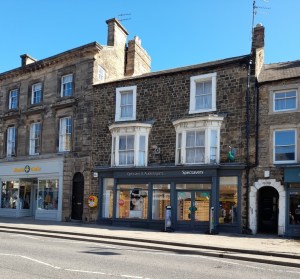
Even the local optician, Specsavers (whose strapline is ‘Should have gone to Specsavers‘) got in on the act offering free eye tests for anyone visiting the town. Needless to say that the visit Steph and I made to this delightful Durham town a couple of weeks ago was not for an eye test.

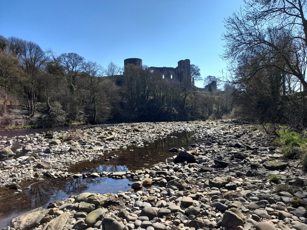
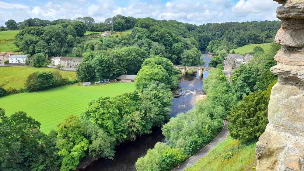
No, we were there to explore the medieval castle built on a craggy outcrop overlooking the River Tees, as well as the ruins of Egglestone Abbey just a couple of miles southeast from the town center. And we planned a drive home over the glorious moorland between Teesdale and Weardale.

And we couldn’t have asked for better weather.

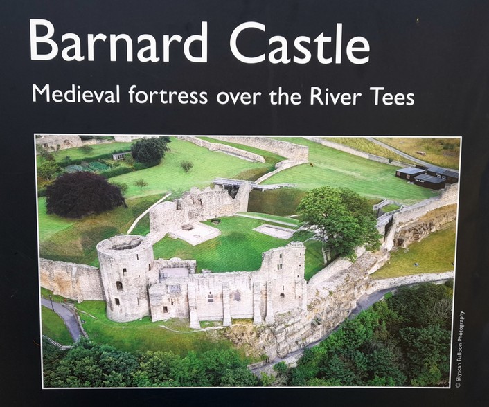
There is a comprehensive description and chronology of the castle’s history on the English Heritage website, so I am not going to elaborate further here, save to post the introduction on that particular page:

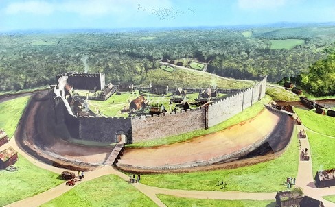
Barnard Castle was begun soon after 1093 on a dramatic site above the river Tees.

The castle was built to control a river crossing between the Bishop of Durham’s territory and the Honour of Richmond. Much of the present castle was built during the 12th and early 13th centuries by the Balliol family. The clifftop inner ward shows the remains of fine domestic buildings, including a magnificent round tower of around 1200.

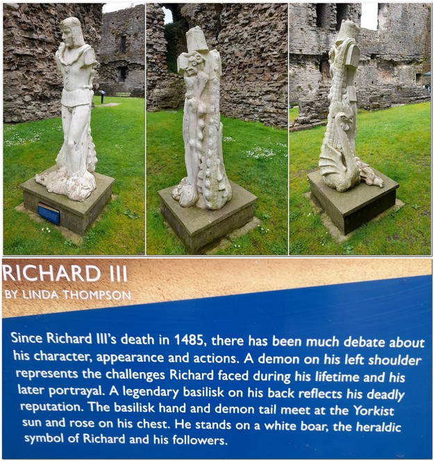
From the 14th century onwards, the castle belonged to the earls of Warwick, and from 1471 to 1485 to the Duke of Gloucester, later Richard III.

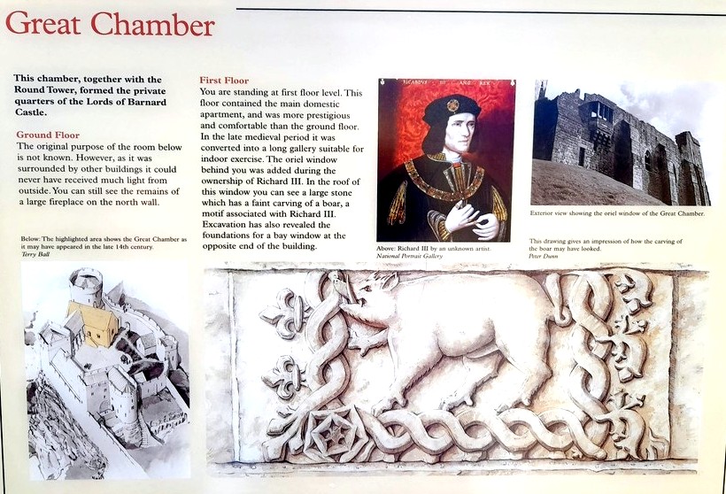
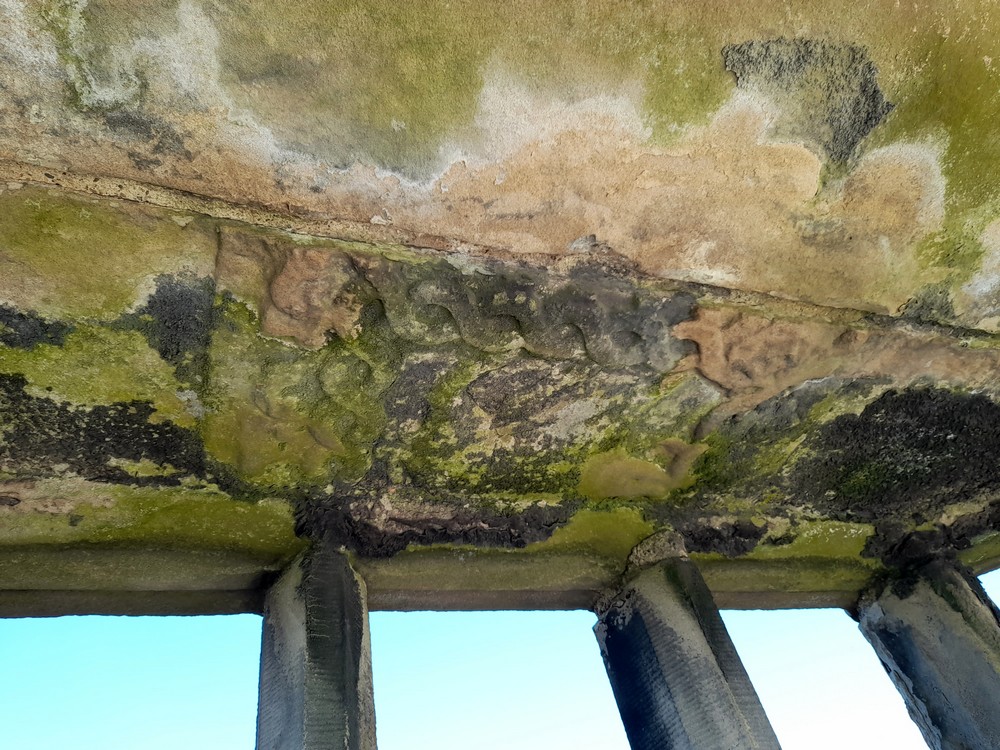
This is the remains of the image of Richard III’s boar above the oriel window.

The round tower and oriel window from below.

After a fierce siege in 1569, when the castle was bombarded by rebels, the castle went into steep decline and was effectively abandoned by the early 17th century. It has remained an imposing ruin ever since.

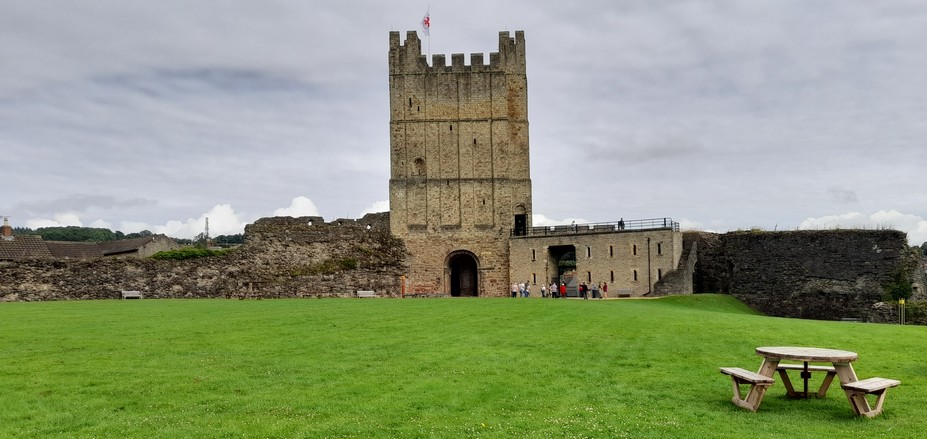
Richmond Castle is just 15 miles southeast, and Middleham Castle (the boyhood home and northern stronghold of Richard III) is another 11 miles south.

Before heading to Barnard Castle, a neighbour had mentioned there was little to see there. Perhaps the ruins of the castle are not as extensive as others we have visited, but all around the site, English Heritage has placed explanatory information boards that put everything in perspective. And the young employees on reception were most helpful in pointing out different points of interest, and where precisely to view the Richard III boar!

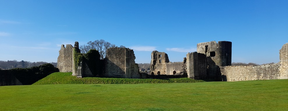
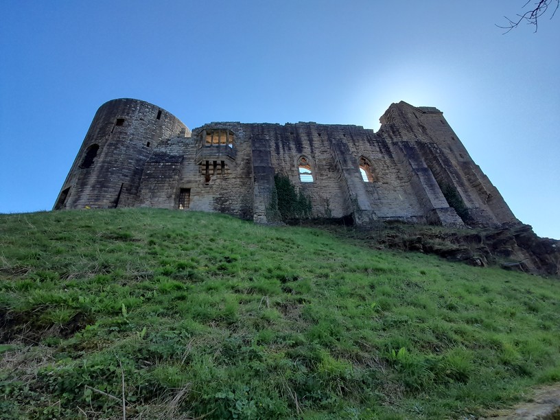
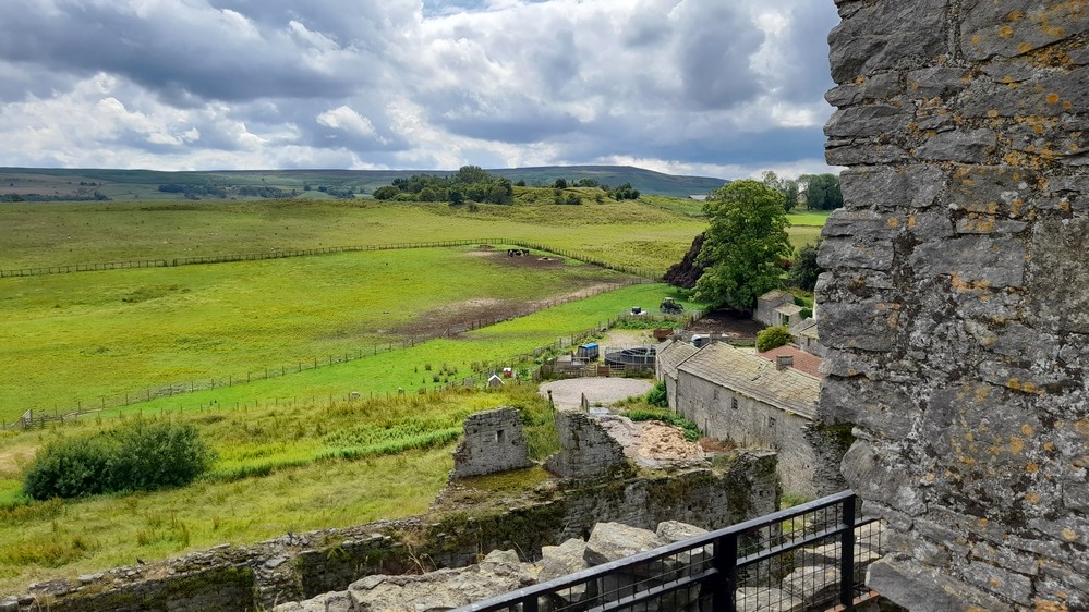
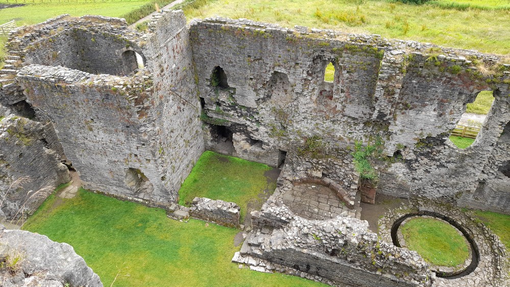
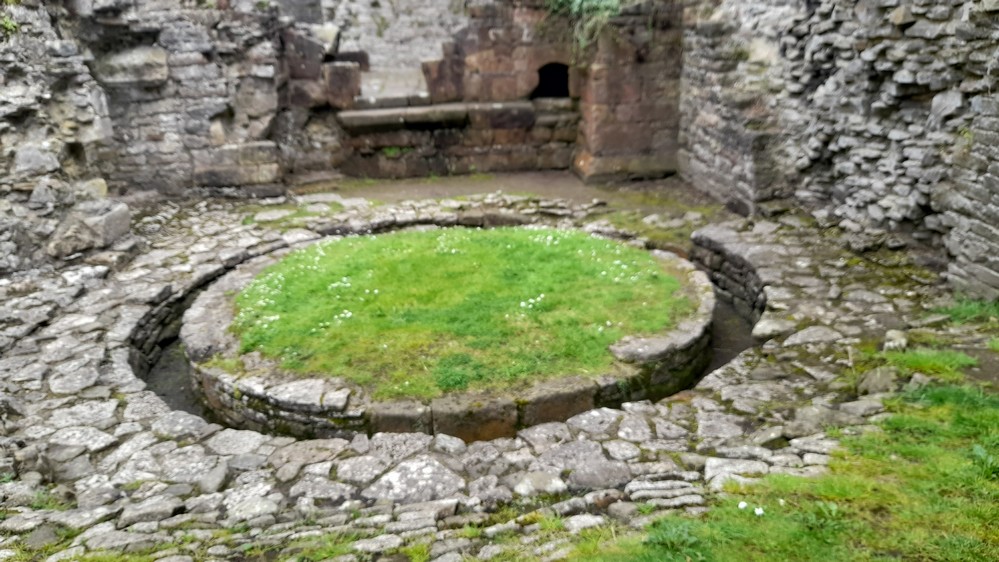
The layout of the castle is a series of courtyards or wards, enclosed in a curtain wall, with the strongest and best fortified being the Inner Ward surrounding the Round Tower, Great Hall, and ancillary buildings like the bakery. The Inner Ward was also protected on two sides by the Great Ditch, and of course on the others by the cliff on which the castle had been built. Click the image below to see a detailed ground plan.

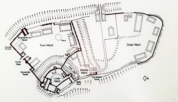
Entering through the main or North Gate, the expanse of the Tower Ward stretches to the Outer Ward.

The Great Ditch is rather impressive, and the Inner Ward is protected by a huge wall across the ditch.

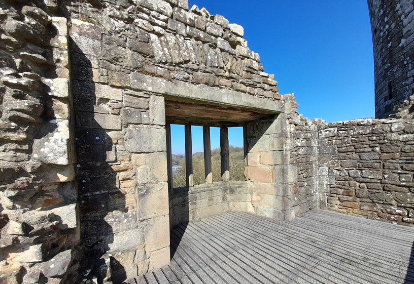
What particularly impressed me about the Round Tower was the beauty of the dressed stone which covers the outer surface. English Heritage has opened the narrow stairs around the tower that take you up to the upper levels, with interesting views inside. Of course all the floors have long disappeared.

You can see the complete album of photos (together with images of the information boards) here.

After a walk down to the river so we could observe the castle in all its splendour on top of the crag, we headed back into the town, passing again past the impressive butter market (officially the Market Cross) built in 1747. It’s had several uses including town hall, fire station, prison, and dairy market.

I should add, for the benefit of anyone contemplating visiting Barnard Castle, that it is a busy town. There is no English Heritage parking at the castle. We parked at the long-term Queen Street car park (cash, cards, and app payment), £1.10 for 4 hours. There are 65 spaces, including two electric charging points. Great value. Well done Durham County Council!


Egglestone Abbey (formally the abbey of St Mary and St John the Baptist) was founded between 1195 and 1198 for Premonstratensian or ‘white’ canons. The only other abbey or priory of this order we have visited was in Kent, at Bayham Old Abbey.

The abbey was never prosperous, indeed quite small. It stands on a rise overlooking the Tees. English Heritage have a comprehensive history account on its website. A ground plan can be accessed here.

Today, the ruins comprise parts of the nave (with both Norman and Gothic doors), the outlines of the cloister and several other buildings, and the east range which was rebuilt in the 16th century, presumably after the Dissolution of the Monasteries. There is some particularly fine stonework.

I have posted more photos of the site and information boards in this album.


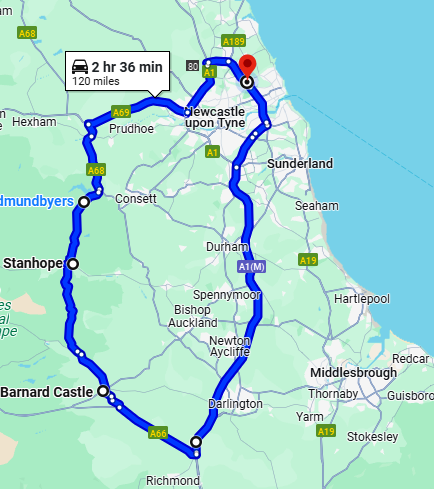
Then it was time to head home, a round trip of 120 miles.

The North Pennines National Landscape is truly spectacular, especially if the weather is good. Here is a video I made from my dashcam. It starts just before reaching Eggleston where we turned on to the B6278 to cross from Teesdale into Weardale, reaching almost 1700 feet at the highest point. It must be grim up there in mid-winter.

In July 2024 we’d visited High Force waterfall, further west up Teesdale from Barnard Castle, and crossed over from Teesdale to Weardale there. In this post you can view the video of that western route, as well as from Weardale to the Tyne Valley. We also took that latter route on our recent trip.


Two castles in one day . . .

The weather during June and July was appalling, very wet and cool. However, summer returned temporarily mid-July so we grabbed that rare opportunity to visit two castles in North Yorkshire, around 62 miles south from home.

Richmond Castle (founded in the 1070s) and 12th century Middleham Castle (just 10 miles south of Richmond) in Swaledale and Wensleydale respectively, are among the most important castles in the north of England, perhaps in the country as a whole. They simply exude history! The former was at the heart of one of the largest post-Norman Conquest estates; the other was the boyhood home and later power base of one of England’s most notorious kings.

I have to admit to being a little disappointed initially with Richmond Castle. Until viewed from the south (which we did as we headed to Middleham, but could not stop because of parking restrictions), it’s not easy at ground level to appreciate just how magnificent it must have been in its heyday. 

Richmond Castle from the south, with the residential accommodation on the right, and the later Keep behind.

Richmond Castle from the air, clearly showing the size of the enclosure which must have been full of other ‘temporary’ buildings when the castle was originally occupied. The residential accommodation is in the top right corner, with the Cockpit Garden beyond.

The original castle was built by Alan Rufus (a cousin of William I, the Conqueror) after 1071 but it wasn’t until the 12th century that the magnificent Keep was added.

An artist’s impression of how the castle must have looked not longer after its foundation in the late 11th century.

By the middle of the 16th century the castle had become derelict, but was revived centuries later and a barracks was built along the western wall in the 19th century, as well as a cell block adjoining the keep. In fact the castle was occupied during the Great War (1914-18) and housed conscientious objectors, with some kept as prisoners in the cell block.

I’m not going to describe in detail the history of Richmond Castle here. There is much more information on the English Heritage website, where you can also find a detailed site plan.

From the roof of the Keep there are magnificent views over the castle enclosure and to all points of the compass around Swaledale and the town of Richmond itself. The castle stands to one side of the market place.

The residential block (Scolland’s Hall), on the southeast corner of the enclosure is contemporaneous with the late 11th century curtain wall, but service buildings were added around 1300.

To the east of this area lies the Cockpit Garden (mainly yew shrubs and lawn) surrounded by walls built in the 12th century and some of uncertain age. English Heritage has developed an ornamental section on the north side.

On the eastern wall there is a small chapel, dedicated to St Nicholas and dating from the late 11th century.

The 19th century barracks block has long since been demolished, but a cell block adjoining the Keep, also from the 19th century still stands, and via steps on to its roof provide easier access to the first floor of the Keep rather than the very narrow and steep spiral staircase in the southwest corner of the ground floor.

There is an excellent exhibition on the floor above the visitor entrance and shop. I wish I’d taken more time to look at the various posters, especially those dealing with the incarceration of conscientious objectors in WW1. Read all about their fate on the English Heritage website

But we’d already decided to move on to Middleham Castle, and having enjoyed a picnic lunch beside the River Swale (reportedly one of the fastest-flowing rivers in England), that’s precisely what we did, crossing over the bridge that replaced an original medieval one.

Middleham Castle is much more impressive, and it’s remarkable how much has survived the ravages of the centuries.

Middleham Castle from the southwest, probably from the site of William’s Hill where an original fortification was constructed shortly after the Norman Conquest.

From the moment you walk through the impressive gatehouse, it’s impossible to ignore the grandeur of this castle, which was more a palatial residence than a fortification.

Close by the castle are the remains of an early castle, probably constructed after the Norman Conquest in 1066. Known as William’s Hill, it can easily be seen from the top of Middleham’s south-east turret as the cluster of trees on the skyline in the image below.

Construction of the stone castle began in the later 12th century, and was extended over several centuries. In 1260, the castle passed into the Neville family, one of the most powerful in the kingdom. Richard Neville (1428-1471), the 16th Earl of Warwick and 6th Earl of Salisbury came to be known as ‘Warwick the Kingmaker’ given the power and influence he wielded.

Middleham’s central keep was one of the largest of any castle in the country, and the oldest part of the castle. There are extensive basements with kitchens, above which were the main hall and family apartments. Surrounding the keep is a curtain wall, with several towers, only one of which is round, the Prince’s Tower on the southwest corner.

English Heritage has a detailed ground plan of the castle on its website. There is also a comprehensive historical account here and illustrations of how the castle must have looked in its heyday. It certainly has the feel of a family residence, a show of wealth and opulence. One feature that English Heritage highlights in its introduction and on ground plan is the large number of latrines, with some dedicated latrine towers. It seems that no-one was ever caught short at Middleham.

The original entrance to the castle was on the east side, but this was changed around 1400 to a gatehouse on the north wall. The entrance to the keep is via a modern stairway to the first floor. As I ascended those stairs I imagined what it must have been like all those centuries ago as guests arrived at the castle and were escorted to their rooms. And ascending to the top of the south-east turret gives a wonderful view over the ruins and the wider landscape of Wensleydale.

Surrounding the central keep on the north, west and south sides, are a series of chambers that must have once been accommodation for staff.

One interesting feature inside the south wall is a large circular ‘trough’, and a raised circular platform next to it. While the left hand feature in the image below is described as ‘ovens’ on the ground plan, there is no description for the trough. 

The ovens and ‘trough’ from the south-east turret.

Both date from the 16th century when, apparently, the local folk were allowed into the castle to use the ovens and the trough. I had to ask, and the best guess is that the trough was a cider press, perhaps as shown in this illustration.

Richard, Duke of Gloucester (1452-1485) was the youngest brother of Edward IV, who spent his boyhood at Middleham (along his elder brother George, who was created Duke of Clarence). The Kingmaker’s two daughters Isabel and Anne grew up at Middleham. Isabel married Clarence, and Anne married Gloucester.

Middleham became Gloucester’s northern stronghold, a base from which to gain power and eventually the crown, becoming King Richard III in June 1483. There is a commemorative statue of Richard just inside the castle.

He was defeated by Henry Tudor (who would become King Henry VII) at the Battle of Bosworth Field (the last significant battle of the Wars of the Roses) in August 1485, where he was killed. And disappeared from history so to speak until his body was discovered beneath a car park in Leicester in 2012-13.

Two castles in one day. Being just a few miles apart it was an easy excursion for us from North Tyneside, and well worth the journey south. A highly recommended day out!

Neither castle has dedicated parking. In Richmond we chose the Fosse Car Park just below the castle. I think it was £3 for 4 hours. There is parking available in the Market Place beside the castle, but I believe it’s more time limited. In Middleham, we parked in Back Street just outside the castle, where there was space for just a handful of vehicles. Parking would be trickier, I guess, on a busier day.


Photo album for Richmond Castle

Photo album for Middleham Castle

The missing monarchs . . .

Although I studied botany and geography as an undergraduate, and then went on to complete graduate degrees in botany, I have often hankered to become an historian. For the past decade much of my reading material has been history – I devour almost anything that looks interesting, and I actively seek out books by authors who I have already enjoyed. And when I retired I did consider taking another undergraduate degree in history.

I find the 18th century a particularly interesting one, because of the significant social changes and transition from an rural-agricultural society to an urban-industrial one. But I don’t focus on that century exclusively.

I have begun to find medieval history rather fascinating, and it comes to mind that the 15th century must be the most violent perhaps in our history. The century began with the usurpation of Richard II’s throne by Henry IV, there was a continuation of the wars with the French, with remarkable success under Henry V (despite the success at Agincourt in 1415, all was lost less than a generation later under the more pacific Henry VI), and of course the Wars of the Roses between the Yorkists and the Lancastrians.

The most brutal and bloody battle of those wars was the Battle of Towton in March 1461, when Yorkist Edward IV defeated the troops of Henry VI. It’s said that more than 28,000 soldiers lost their lives. But despite its tragic cost, I read somewhere that there was proportionately greater loss of life during the English Civil Wars from 1642-1651 than in any other conflict in these islands. No doubt the Black Death of the late 14th century must also have been a serious genetic bottleneck for the population at large to survive.

But I digress. We know the burial sites for all English monarchs from William the Conqueror until the accession of James VI and I in 1603, for the Stuart kings and queens of both England and Scotland, and monarchs of the United Kingdom from 1714 onwards when George I (great grandson of James VI and I through his eldest daughter Elizabeth of Bohemia, the so-called Winter Queen) came to the throne.

With the exception of two – but that may be about to change.*

Richard_III_earliest_surviving_portraitI refer of course to Edward V (never-crowned elder son of Edward IV, and one of the Princes in the Tower) and Richard III.

It’s always thought that the princes, Edward and his brother Richard, were murdered on the orders of Richard III when he, shall we say, extended his powers as Lord Protector, and had himself crowned king in 1483. Although skeletons thought to be those of the princes were found in the Tower in 1674 and later re-interred in Westminster Abbey on the orders of Charles II, we cannot be sure that these remains are theirs.

Our image of Richard III – who was widely admired, and loved even, in his northern lands during his lifetime – comes down to us from Shakespeare and Tudor propaganda. After the Battle of Bosworth Field in 1485, when Richard III was killed, Henry Tudor (who became Henry VII) established the Tudor dynasty on the flimsiest of claims, and he and his son, Henry VIII, did their best to eliminate any possible Yorkist rivals (and any others who might have a better claim to the throne than themselves). Best not to think of Laurence Olivier’s cinema portrayal of Shakespeare’s Richard III, although I fear that’s the wicked image many of us continue to carry in our minds.  Of course there are those who have always felt that Richard III was maligned.

http://youtu.be/px5hvNWoVLE

Now although there’s a tomb for Richard III in Leicester Cathedral, there’s no body – it was lost after Bosworth, but reportedly buried in Greyfriars priory in Leicester that was subsequently destroyed, and now the site of a car park.

And that’s what we hope to find out very soon. Bringing together the best of modern science: GIS, geophys (as Time Team‘s Tony Robinson would say) to explore underground structures, carbon dating, and DNA analysis (presumably of mitochondrial DNA), a team of archaeologists from the University of Leicester descended some months ago on Greyfriars car park in the city. Very soon they discovered a skeleton that had obviously undergone some trauma, as well as showing a deformation of the spine, or scoliosis, that Richard was reported to suffer from.

Could these be the remains of Richard III, and if so, where should he be reburied? Soon we will find out, once the carbon dating and DNA analysis are completed by the beginning of February. How exciting! Reports leaking to the media are definitely supporting the Richard III identity. Here’s a link to a recent interview given by the project team.

If we have found our last remaining monarch, where should he be buried? The Ministry of Justice will make a decision, it’s said, next week. In any case, one of the conditions of the excavation and exhumation of the skeleton was that any remains would be re-interred in Leicester. And as I mentioned earlier, he already has a tomb in the cathedral, albeit empty. The residents of York would like him buried in York Minster, and there are those who argue he should be buried alongside other monarchs in Westminster Abbey in London. After all, that’s where Richard’s queen, Anne, is buried.

So, fingers crossed, we’ll soon have an answer to a long-standing mystery, and one that modern science is helping to solve.

* Today (4 February 2013) the archaeologists at the University of Leicester have announced that the skeleton unearthed in the Greyfriars carpark in Leicester is indeed that of King Richard III.