There’s water everywhere, notwithstanding all the lakes that characterise Minnesota. It’s not for nothing that Minnesota is known as ‘The Land of 10,000 Lakes’.
The Minneapolis-St Paul metro area (the Twin Cities) is surrounded (almost) by water. I’m talking about rivers. Large rivers.
The mighty Mississippi River bisects the cities. The Minnesota River is a southern boundary to Minneapolis. And the St Croix River is the state line between Minnesota and Wisconsin just east of St Paul, and its confluence with the Mississippi is just south of St Paul.
The Twin Cities (and surrounding areas) have their fair share of bridges – road and rail – that cross all of these rivers. There are twenty six highway bridges across the Mississippi, eight across the Minnesota River, and five across the St Croix (and another being constructed to relieve Stillwater of its congestion at the Lift Bridge.
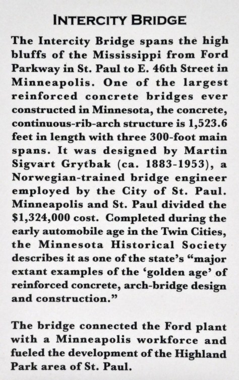
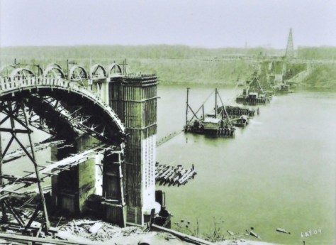
Closest to where our daughter and her family live in the Highland Park neighbourhood of St Paul is the Mississippi River Bridge. Or should that be the Intercity Bridge, the Ford Parkway Bridge, or even the 46th Street Bridge? Its official name is ‘Intercity Bridge’, but at both ends there is a plate stating that the name is ‘Mississippi River Bridge’.
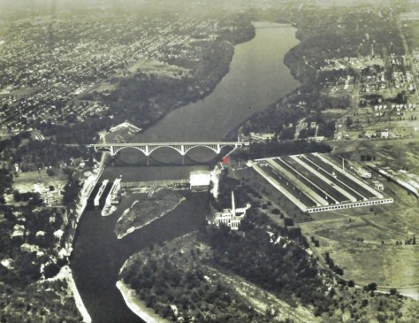
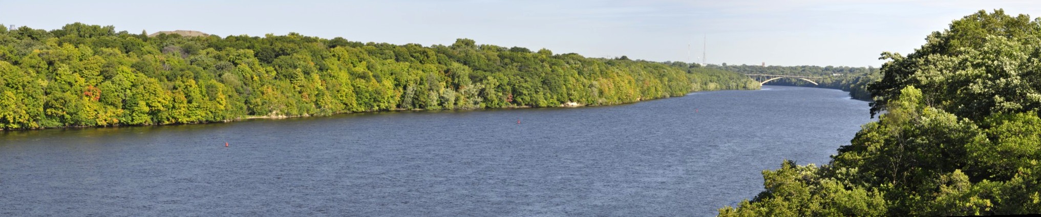
The Intercity Bridge, looking north from the Lock and Dam 1. Photo downloaded from the Minnesota Department of Transportation website.
Work began on this beautiful bridge in 1925, and it was completed two years later. It connected Minneapolis with the Ford Motor plant on the St Paul side of the river, now closed and demolished.
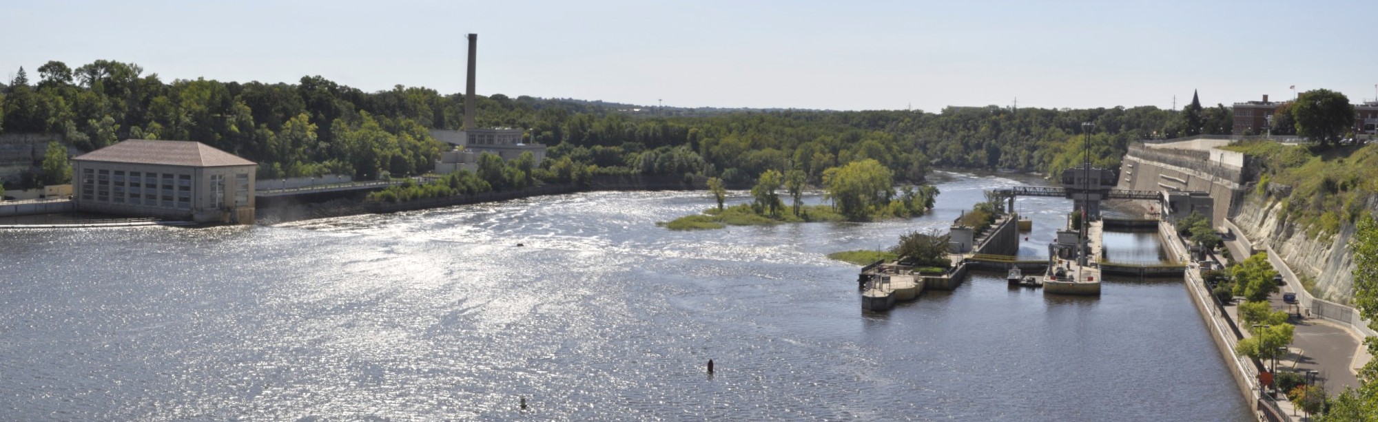
The following five photos were taken from an information booth above the old hydroelectric plant.
The Ford Motor plant is on the eastern side of the Intercity Bridge. Below the bridge is the hydroelectric plant that provided power for Ford.
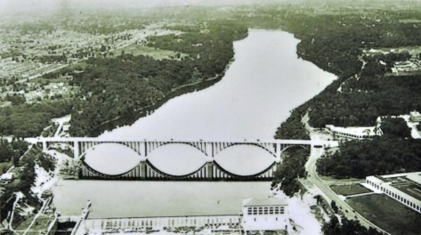
Now that the trees have matured along the banks of the Mississippi, there are few clear views of the bridge from the banks, even from the viewpoints.
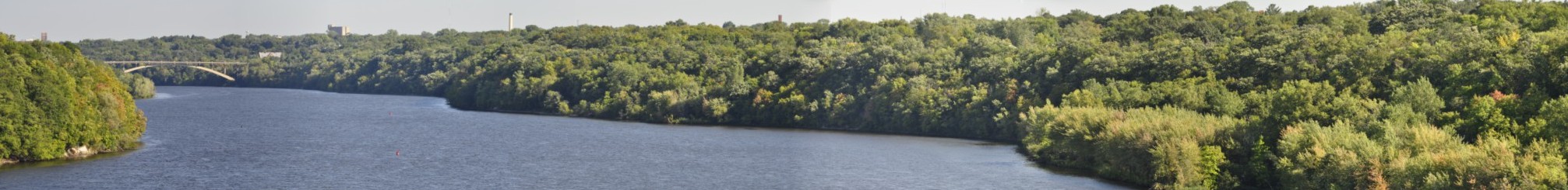
The next bridge upstream is the Marshall Avenue bridge, and can just be seen from the Intercity Bridge. Our daughter Hannah now lives just beyond the river bank treeline on the right of these photos, on Mississippi River Boulevard.
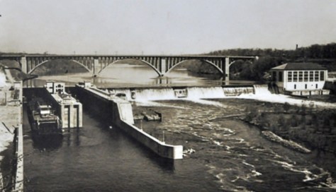
This is the view today of the hydroelectric power station, the dam and lock below the bridge.
About a mile further down river is Hidden Falls Regional Park. The road drops steeply down the bluff to the water’s edge. And there you get a real appreciation of the majesty and power of the flow of the Mississippi, even though it’s over 1200 miles to the ocean at the Gulf of Mexico.
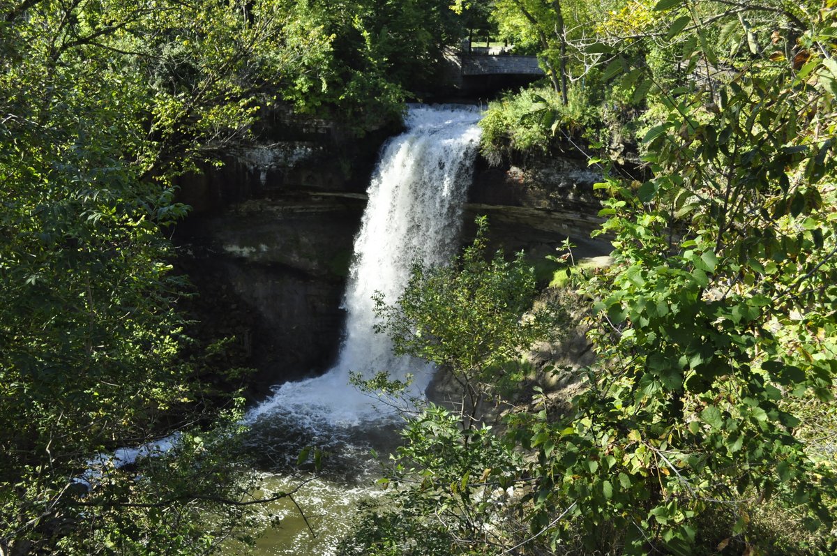
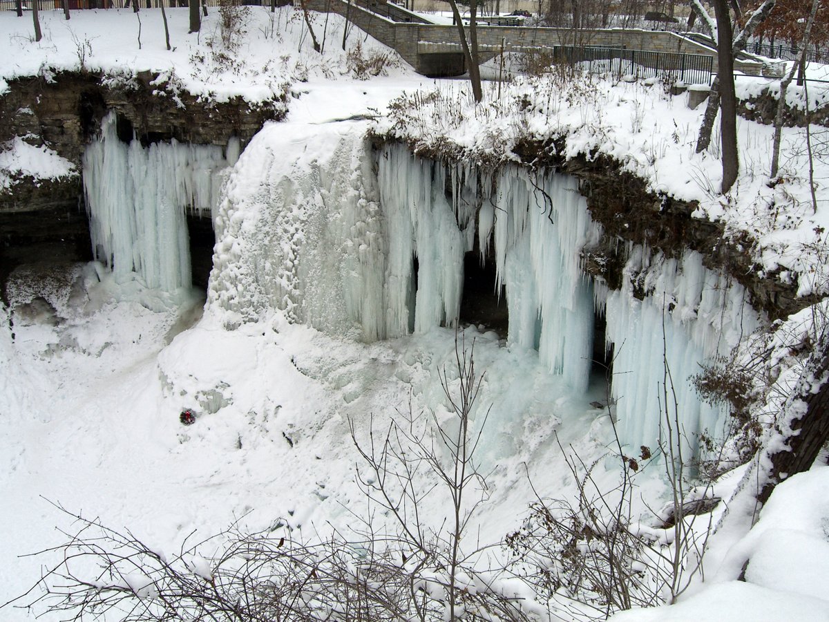
Just over the Intercity Bridge on the Minneapolis side is Minnehaha Regional Park, and the beautiful Minnehaha Falls. On a visit to St Paul at Christmas 2007 we saw these Falls under very different circumstances: completely frozen. But not yesterday.
Size does make a difference after all. Well, at least when it comes to airline seats. Not that the actual dimensions of Delta Comfort+ and regular Economy seats are different. It’s just that there are an extra four inches or so between the rows in Delta Comfort+ section of the cabin.
And what a difference those four inches actually make, as I commented last year. So, even though the cost of the Comfort+ upgrade had increased by £100, we felt that the added space and comfort (really the ability to move around in one’s seat, and not have the seat in front in your face) was worth the extra expense.
And that’s how we travelled to Minnesota just a couple of days ago, for our annual visit to St Paul to stay with Hannah and Michael, and grandchildren Callum and Zoë.
We arrived to Birmingham airport (BHX) around 09:10 for our 11:25 flight (operated by KLM Cityhopper) to Amsterdam Schipol (AMS, that takes around 55 minutes), only to discover that the check-in desks did not open until 09:25. Not the best situation for me these days, standing around on my weakened right leg. Anyway, once we had checked in our bags, we went through security quite quickly, although Steph was given a random check for explosives, and the hand gel that I was carrying was given special scrutiny.
Sitting in the departure lounge at BHX waiting for our flight DL9415 (operated by KLM Cityhopper) to Amsterdam Schipol (AMS).
Our flight (an Embraer 190 aircraft) was boarded quickly, and the captain advised us that, at 11:10, we were ready to depart early. Only to come back on the blower just a couple of minutes or so later to tell us that two passengers had decided not to fly after all, and their bags would have to be found and removed from the aircraft. After all this we actually departed about 10 minutes late!
Being a Cityhopper flight, we arrived to a ‘bus gate’ at Schipol. This was actually rather convenient, since the entrance into the D pier was close to Gate D1 that Delta uses exclusively to process all its passengers but does not actually board any flight from there. And even better, our Minneapolis-St Paul flight DL165 was scheduled to depart at 15:35 from Gate D3. No long walks for me in Schipol last Tuesday, which was quite a relief.
I asked for priority boarding, and Steph and I were the first passengers on board the Delta A330-300, and quickly settled into our seats.
Around 15:30 (after we’d been on board for about 40 minutes) the captain said we were ready to depart, but then advised us that engineers were working on a fault with the water and vacuum system for the toilets (now that was an issue I’d experienced recently on my flight from Lima to Cali, Colombia), and there would be a slight delay. Ultimately we departed about 25 minutes late (and arrived into MSP delayed by about the same time).
Once we were on the move, we had a very smooth takeoff from runway 24, and climb out of the gloom over Amsterdam.
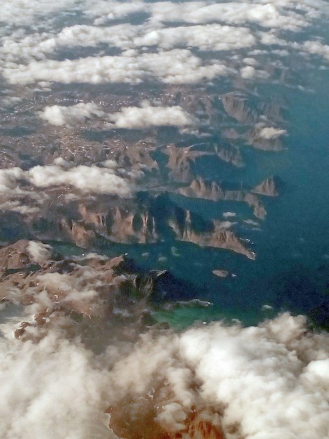
Initially, our flight headed towards London, and didn’t turn northwest until we had passed Bristol. That’s quite unusual based on previous flights, when we headed out from AMS towards Scotland. Anyway, we crossed Ireland, passed south of Iceland and Greenland, and heading in over North America on the coast of Newfoundland and Labrador, over Hudson Bay and Ontario in Canada, before the long descent into MSP once we had crossed the US-Canada border north of Duluth.
There wasn’t a great deal to see until we crossed the coast of Newfoundland, and then there was a spectacular view of the rugged coastline, with inlets bordered by precipitous cliffs.
The spectacular coastline of Newfoundland and Labrador.
Mostly it was cloudy, with odd view of an island or two as we crossed the southern part of Hudson Bay.
But for once, it was an incredibly smooth flight almost the whole way. In fact I can say that we experienced no turbulence at all, apart from the occasional little bump. And even though stormy weather had been predicted for our arrival around 18:00 in MSP, and the captain advised us during the descent that the approach could be rather bumpy, we had no bumps at all.
Nevertheless, a nine hour flight is a long time. Having made the same flight before in a regular Economy seat, and knowing how uncomfortable I was, the upgrades to Comfort+ have been worth every penny.
Also, the odd Bombay Sapphire or three during the flight certainly helps. I read something today that drinking gin is good for you. I don’t need any excuse. I enjoy it for itself, and also for the fact that it relaxes me during flights such as Tuesday’s.
Delta serves a limited menu in Economy Class: chicken and . . . Having previously opted for the hot dish (and invariably regretted having done so), I decided to try the cold chicken salad, and surprisingly quite satisfied with my choice. About four hours afterwards the cabin crew came around with a snack – quit bizarre, but nice nevertheless. It comprised crackers and a red bell pepper spread, and a sachet of about a dozen green pitted olives. Never had anything like that on any flight before. Then just 90 minutes out from MSP we were served a hot cheese and chicken sandwich, and some ice cream.
On arrival at MSP we were off the plane quickly and among the first passengers through Immigration. Our bags arrived quickly and before we knew it we were out and meeting Michael and the grandchildren.
Yesterday was still quite stormy and wet in St Paul, and we didn’t manage a short walk until quite late in the afternoon. Hannah and Michael moved house a few months back, just a few blocks from where they had been living. But it’s a larger house, and along the Mississippi River Gorge. These next photos were taken just a couple of minutes away from their house.
We are here in St Paul for the next three weeks. Although we don’t yet have any firm plans to travel, we are contemplating a short break in the north of the state, at the headwaters of the Mississippi and Itasca State Park. Some of the trees here in St Paul are already beginning to show the first signs of autumn colour. Perhaps we will see a more spectacular display in northern Minnesota.
I’m a bit of a news junkie, so I’ve been avidly following presidential election campaigns in three countries in online newspapers and on social media.
News from the US presidential election is never absent from the daily headlines, mainly because the two principal contenders on the Republican side, billionaire Donald Trump (or is that Donald Drumpf)¹ and evangelical Senator Ted Cruz, battling it out to win the nomination, increasingly descend to ever lower levels of political debate. Political debate? Their exchanges are not worthy of that epithet. Trump is hardly running an election campaign. I think it would be better to describe it as an election ego-trip.
You would hardly know there’s also an interesting contest on the Democrat side between former First Lady, New York Senator, and Secretary of State Hillary Clinton and Vermont Senator Bernie Sanders. At least they seem to be having a sensible debate.
The other campaigns that interest me are taking place in Peru in April, and in the Philippines in May. Why? Because I have lived and worked in both those countries.
Reading about the three campaigns, two quotations come to mind:
Toute nation a le gouvernement qu’elle mérite(Every nation gets the government it deserves) — attributed to Joseph de Maistre (1753 – 1821)
Democracy is being allowed to vote for the candidate you dislike least — Robert Byrne
Goodness knows what sort of campaign there will be in the US after the party conventions if Trump really does become the Republican candidate. He’s both scary and a worry. What will happen if he is ‘denied’ the nomination, and how will his supporters react. The violence we have seen so far directed by these folks against anti-Trump protesters does not bode well for the future.
But there are scary things going on in the Cruz camp as well. He is a right-wing evangelical Christian. And I’ve recently seen footage of him sharing the stage with a fundamentalist Christian preacher who, through his language was inciting Christians to violence, death even, against homosexuals. Because it says so in the Bible.
On the Democrat side, I’m actually surprised how well Bernie Sanders is doing, although I can’t believe he can win the nomination. Nor can I see a 74 year old candidate moving on to be a successful president.
In Peru and the Philippines, some of the candidates are as old as Sanders, but the political situation there is very different from the USA.
The polls in Peru seem to be dominated by Keiko Fujimori, daughter of the disgraced and gaoled former President Alberto Fujimori (who I met in the Philippines during his visit to IRRI). But Fujimori – daughter is also a controversial politician, believed to have benefited personally from her father’s corrupt government. Nevertheless, she is predicted to win the first round of voting. Another discredited candidate is the APRA former president Alan García who served two terms already (1985-1990, 2006-2011).
In the Philippines, which has a party system even weaker than that in Peru, the lists of candidates for both president and vice-president are filled with controversial characters. The posts of President and Vice-President are voted for separately (not as a single ticket in the USA), and it’s often the case that elected candidates come from different political persuasions and diametrically-opposed political platforms.
The current Vice-President Jejomar Binay heads yet another political dynasty, and has been accused of overwhelming corruption. The Mayor of Davao City (in Mindanao) Rodrigo Duterte has served his city for more than two decades, successfully apparently, and regarded as a political ‘hard man’. How a Duterte Administration would pan out nationally is anyone’s guess. Senator Miriam Defensor Santiago is an outspoken – and (formerly) popular – international lawyer who, once she had declared her candidacy (despite being near death’s door from Stage 4 lung cancer only a short time before), was thought to be well placed to win the presidency. Until, that is, she chose Senator Ferdinand Marcos, Jr. (aka ‘Bongbong’) as her running mate for vice-president. Son of former dictator Ferdinand Marcos (ousted in a popular uprising in 1986), Bongbong is widely regarded as corrupt and implicated in many of the worst human rights excesses of his father’s regime. Another, Senator Grace Poe, has had her candidacy questioned because of her nationality, having taken US citizenship at one time, which she has now renounced. Which leaves us with the ‘administration’ candidate and Secretary of the Interior and Local Government, Mar Roxas (a scion of yet another political dynasty). Is his wife Korina Sanchez a political liability??
So, in all three countries, the electorates are faced with choosing Presidents or Vice-Presidents from lists of some unsavory candidates, several of whom do not qualify (in my opinion) on ethical or moral grounds to ask for anyone’s vote, never mind political acumen or leadership potential, not even for the most humble elected post.
There will be bumpy political times and roads ahead in all three countries, whatever the election outcomes. Although not a General Election, we face an uncertain political (and economic) future here in the UK with the referendum on continuing membership of the European Union being held on 23 June. Political campaigning and false arguments have not brought out the best on either side of the referendum debate.
~~~~~~~~~~~~~~~~~~~~~~~~~~~~~~~~
¹ See the full 22 minute video here.
Over the years, I’ve had the opportunity of visiting many of the ‘great’ cities in the USA: New York, Washington DC, St Louis, San Francisco, Seattle, and Chicago (most recently). But the city (or should I say cities) I have visited most over the years are the Twin Cities of Minneapolis and St Paul in the heart of Minnesota.
And for good reason. First, when I was traveling to the USA in the early 1990s, the international airport in the Twin Cities (MSP) was the hub for Northwest Airlines (now absorbed into Delta), and was the most convenient way for travel from Manila in the Philippines into the USA.
Since September 2008, however, St Paul has been home to our elder daughter Hannah. After completing two years of her 3-year psychology and anthropology degree at Swansea University in the UK, she asked us if she could transfer to Macalester College in St Paul, a highly-respected—but small (maybe 2000 undergraduates)—private liberal arts college that counts former US Vice President Walter Mondale and UN Secretary General Kofi Annan among its notable alumni. The most recent winner of the Man Booker Prize for an original novel in the English language is Macalester professor Marlon James.
So, over the years we have visited many times and come to know and appreciate the Twin Cities, although St Paul is the half of this metropolitan duo that we know much better. There’s a vibrant community, and the cities have something for everyone. It’s pretty laid back, but I guess you could say that about Minnesotans in general. Maybe that’s why I like Minnesota so much.
Among the things I like are the breakfast diners (I like the Grandview Grill on Grand Ave, just below Macalester), some of the best ice cream I’ve tasted anywhere at Izzy’s on Marshall Ave, and only St Paul can boast the Fitzgerald Theater, home of Garrison Keillor’s A Prairie Home Companion.
But what sets the Twin Cities apart, for me at least, are the numerous lakes dotted around the Minneapolis side, and the tree-lined avenues everywhere. In fact, it’s hard to imagine cities that are more leady. And taking into account that Minneapolis-St Paul was founded on the banks of the Mississippi River, and on the ‘edge of the prairie’, the amount of tree planting over a century or more is implrsssive. Certainly the avenues are lined with some of the most impressive specimens I’ve seen anywhere, often up to 100 feet tall.
In the (speeded) video clip below, our recent return flight to Amsterdam took off from Runway 30L to the northwest, climbing over the Tangletown and Linden Hills districts of Minneapolis, over Lakes Harriet and Calhoun, before turning right, and heading northeast over the Mississippi just north of downtown Minneapolis, and continuing over the norther suburbs of St Paul.
There are some pretty fancy properties around the two lakes, but you can’t see them for the trees. It would be the same if you landed from the west or took off to the east and had a view over St Paul, which lies on the eastern bank of the Mississippi. Trees everywhere. And of course north of the Twin Cities, the landscape is dotted with lakes large and small. Not for nothing is Minnesota known as the state of the Thousand Lakes.
Hannah and her family live between the Macalester-Groveland and Highland districts of St Paul, just three blocks from the mighty Mississippi. Steph and I have mostly visited during the spring or summer months, so we get to see everywhere at its best in terms of flowering and in leaf. And this is what so impresses us as we take our daily constitutional down to the bank of the Mississippi and along boulevards lined with the most impressive trees. And of course there are some very fancy properties along there as well.
The view from the Ford Parkway bridge crossing over the Mississippi River, and looking north towards the Marshall Avenue bridge. Hannah lives just three blocks east of the river.
But having so many tall trees so close to residences has its drawbacks as well, as we saw in June 2013 after a short-lived but rather violent storm passed through (tornadoes are not unknown, but infrequent). Just close to where Hannah lives several large trees had been brought down, and fortunately the damage to houses was much less than we first feared.
Now although we’ve visited mainly in the summer months as I mentioned, we did spend one Christmas with Hannah and Michael in 2007. And what a baptism of cold it was. I don’t think I’ve ever experienced such cold. And don’t forget we had left the tropical weather behind having just flown in from the Philippines! Nevertheless it was fun, and once suitable wrapped up against the cold we did get out and about on foot to savour the experience.
One interesting comparison we were able to make this September was when we walked from Hannah’s home to Minnehaha Park, just under two miles away. There is an impressive waterfall, which we have now seen in two contrasting seasons.
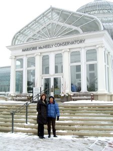
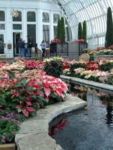
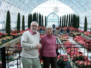
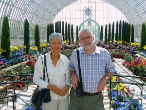
One of our favorite places to visit is Como Park, where there’s a small zoo and the Marjorie McNeely Conservatory. The conservatory is most exquisitely planted all year round. On a cold day in December it was a wonderful place to get out of the cold, and escape from the grey-out of a cold Minnesota day. But the conservatory was the location where Hannah and Michael were married in May 2006. We had the whole place to ourselves, and it had recently been planted with summer bedding plants. What a delight!
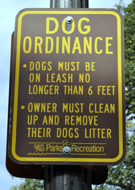
There’s also one aspect of walking around the Mississippi River area that we appreciate. It’s both human and dog friendly, because there are strict ordinances restricting the length of dog leashes.
Crossing the Great Plains east to west, and west of the Badlands, you become aware of a dark line on the horizon. Is that an approaching storm? It could well be. But as you get closer you realize it’s an isolated range of hills, rising about 4,000 feet above the surrounding plains. These are the Black Hills of South Dakota, which have their maximum elevation in Harney Peak (7,244 feet). Sacred to many of the Native American tribes of the Great Plains – principal among which were the Sioux – their sanctity was violated when the 1868 Treaty of Fort Laramie (which had ‘supposedly guaranteed ownership of the Black Hills to the Lakota and other tribes) was broken following by the discovery of gold (ironically by General George Armstrong Custer). The United States government was unable (or incapable) of preventing the invasion of the Black Hills by miners. Conflict between the settlers and the Native Americans was inevitable.
For many – certainly on this side of the Atlantic – their first introduction to the Black Hills must have come from the 1953 movie Calamity Jane starring Doris Day in the title role and Howard Keel as Wild Bill Hickok. Certainly it was a highly sanitized (and fantasized) interpretation of events around that time. But who can forget this particular song? Released as a Doris Day solo, I certainly remember it very well from my childhood right through the 1950s.
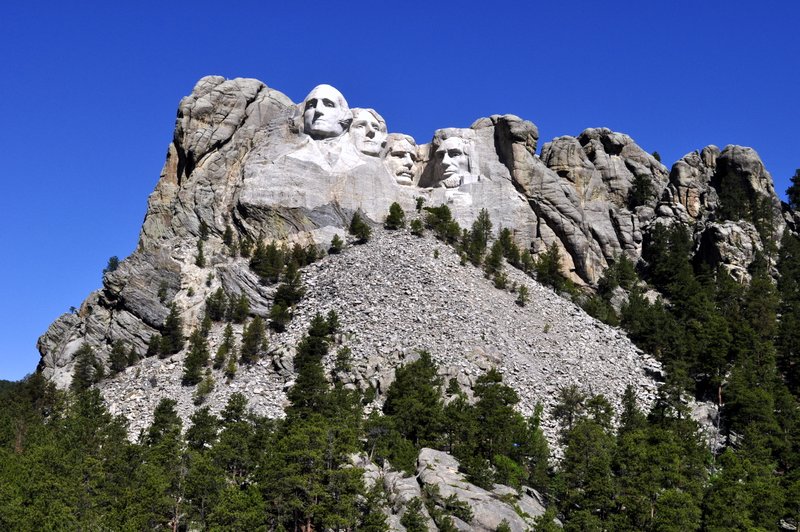
Mount Rushmore
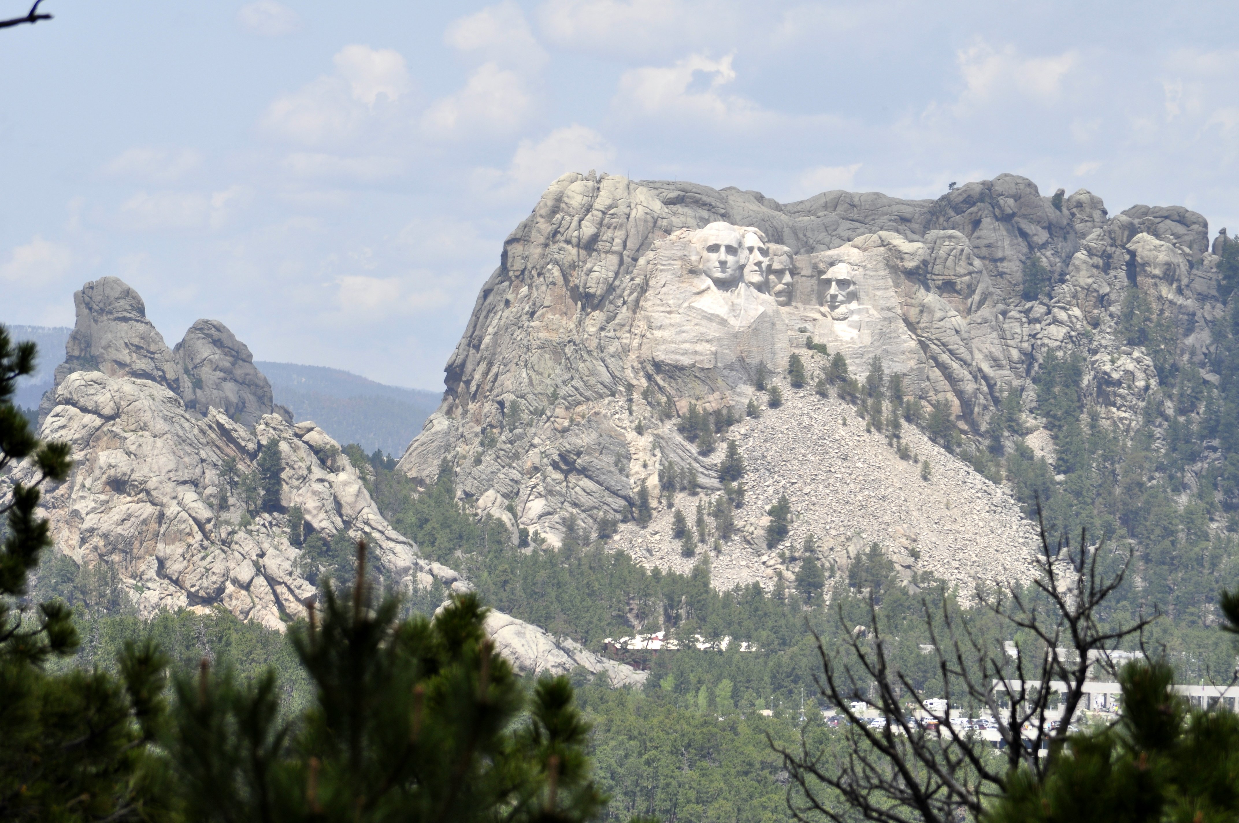
We were heading for Rapid City and the Black Hills with one particular destination in mind: Mount Rushmore National Memorial. Under normal circumstances, I wouldn’t normally visit an attraction like Mount Rushmore. Like many others I’d seen my first images of this iconic location in Alfred Hitchcock’s North by Northwest. I guess I thought the whole experience would be rather kitschy – and my fears were not allayed as we drove from Rapid City to Keystone in the heart of the Black Hills, and on to Mount Rushmore, just a mile or so beyond. Either side of the highway were various tourist attractions that I would never visit in a month of Sundays. Just not to my taste.
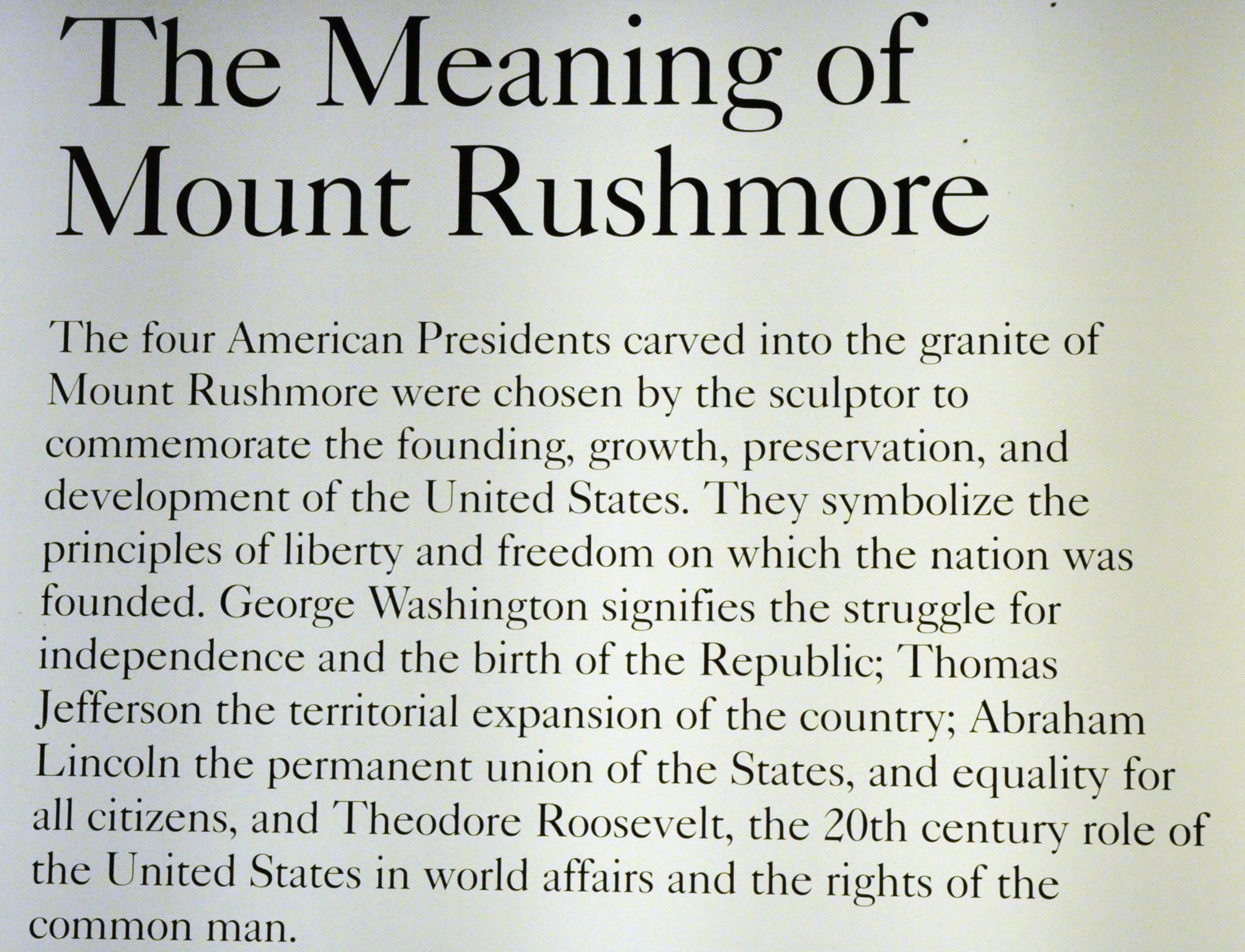
But how wrong I was about Mount Rushmore. In fact it was almost an emotional experience. The day was superb; hardly a cloud in the sky, and we joined several thousand more tourists (many from Asia) to marvel at the wonder of the Mount Rushmore National Memorial and how the faces of four famous presidents Washington (#1), Jefferson (#3), Roosevelt (#26), and Lincoln (#16) came to be carved into the side of a mountain. And why these four presidents were chosen from all the possible candidates. Although I guess the contributions of some presidents to the development and well-being of the United States are best forgotten.
There is so much more written about Mount Rushmore in the link provided above – and more than I can eloquently draft; other details are provided by the National Park Service.
I was overwhelmed by Mount Rushmore – no doubt the beautiful day helped. But I was also inspired, not only about the people who had the foresight to create this national memorial, but also that the choice of these four presidents encapsulates the history of their diverse nation. So let me tell some of my Mount Rushmore story through the images I captured that June day.
Before the work began . . .
Mount Rushmore, SD
Four presidents in the sky
The Black Hills and Custer State Park
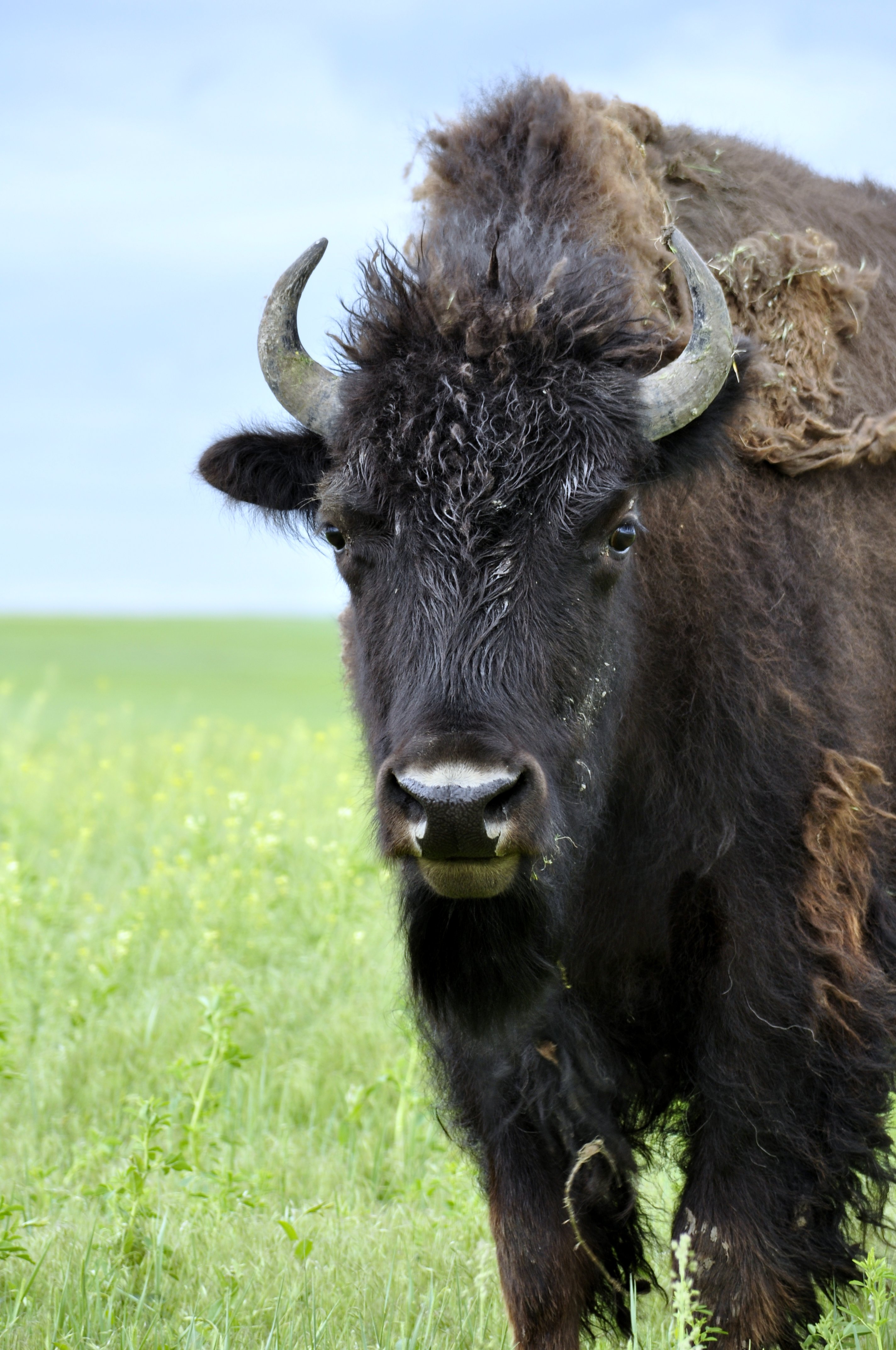
Traveling south from Mount Rushmore, and passing through several tunnels just wide enough for a SUV but no bigger, there is an opportunity of experiencing the beauty of the Black Hills – and appreciate why Native Americans held this place to be so special. In Custer State Park there is a healthy herd of about 1,300 bison, some of which we came across. A hugely damaging fire in 1990 opened up much rangeland, but even so, there is a bison round-up each September to manage the herd, and sell several hundred animals and keep the herd at a level which the park can sustain.
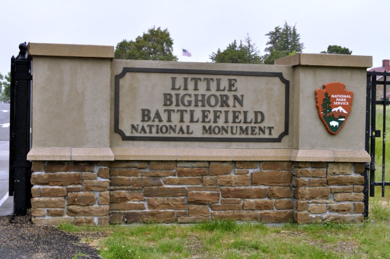
Taking a roundabout route back to Rapid City, we enjoyed the Needles Highway between Custer State Park and Hill City, and traveling north, we then took the back highway Sheridan Lake Road into Rapid City for our second night there. We didn’t visit the half-finished Crazy Horse Memorial, however. It was rather out of our way, but also it seemed to me to be a rather more exploitative and touristic attraction. There’s actually no known image/photo of Crazy Horse – one of the most important Indian leaders who played a pivotal role in the defeat of General Custer at the Battle of the Little Bighorn in June 1876, and who perhaps deserves a more fitting memorial in any case.
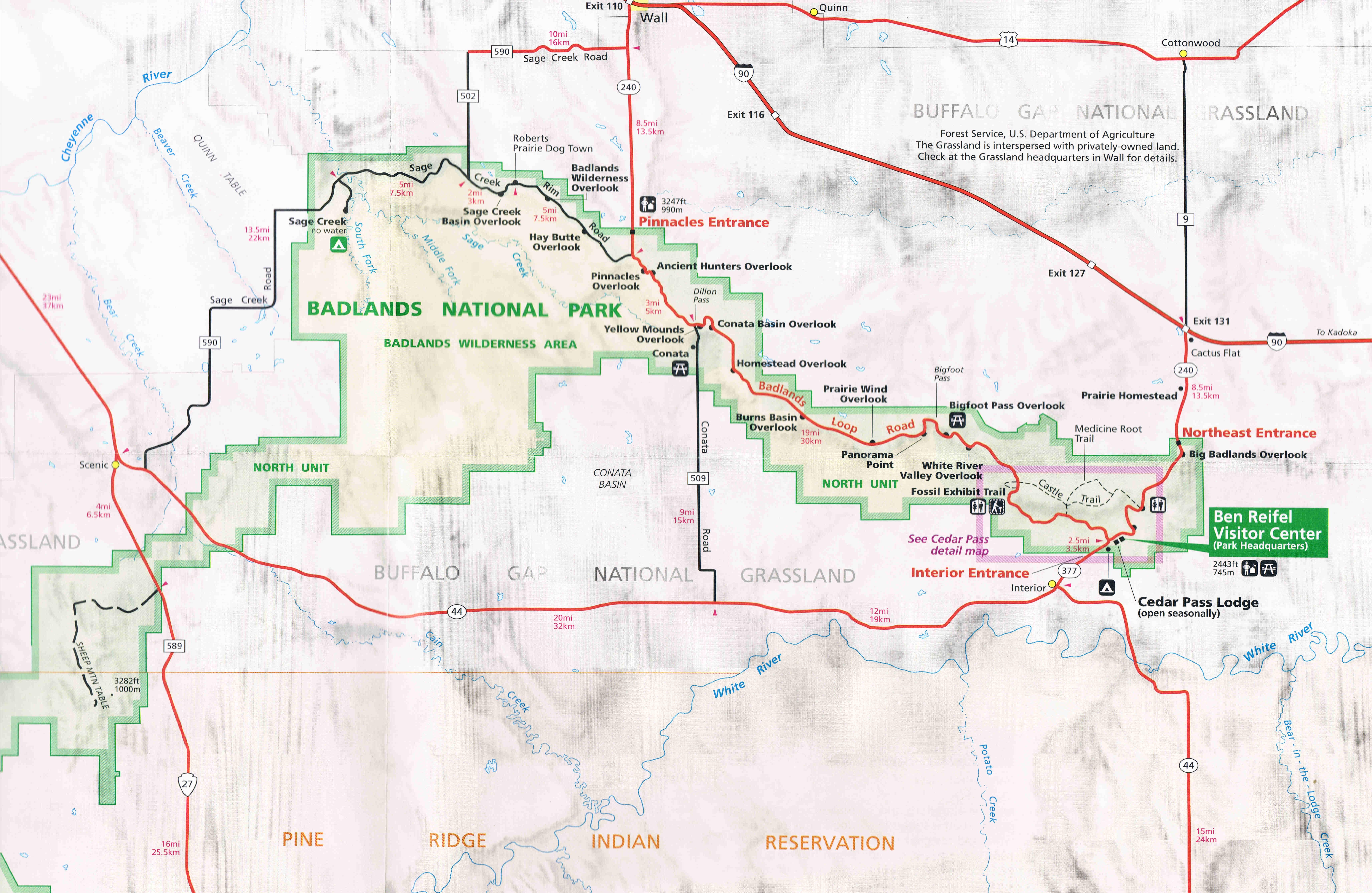
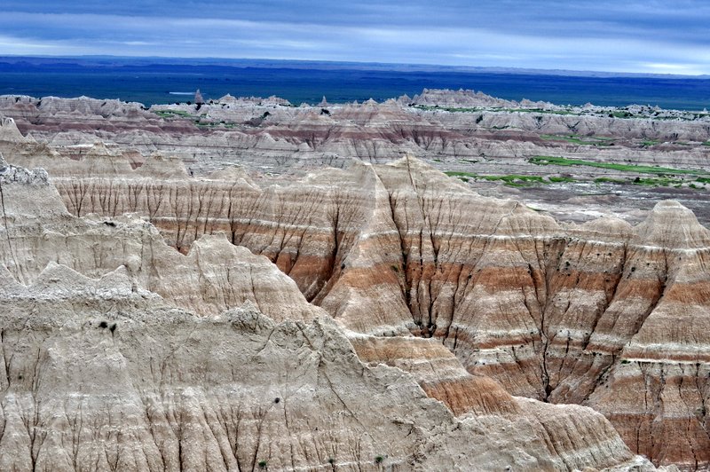
It was a Tuesday morning, early June. We’d reached Chamberlain, South Dakota on the banks of the Missouri River the evening before, having traveled down from St Paul, MN in glorious sunshine. To the west, however, there was an ominous glower in the sky that was already beginning to darken by breakfast-time. Checking the Weather Channel we learned to expect some thunderstorms as we crossed the Great Plains towards our next destination: the Badlands.
Stormy weather? That was that half of it. At one point it was raining so heavily I had to pull off the highway (I90) at one of the designated viewpoints. Not that we could see anything. However, after about 30 minutes we were able to continue our journey, and later found out that we had skirted the northern edge of a major storm tracking across the plains from west to east, accompanied in some places by baseball size hailstones. Luckily we missed those, and by the time we reached the Badlands National Park, the storm had passed, the skies brightened (a little) and we were able to enjoy the Badlands formations in all their glory.
Having now traveled across the Great Plains for several hundreds of miles, my respect has increased enormously for the early pioneers who crossed these open spaces in the 19th century on their way to the west coast, in California and Oregon, to make a better life for themselves. Not only did they have to combat the natural obstacles of the landscape – the plains, the Rockies, and the Sierra Nevada – but also hostility from the native Americans whose land they were crossing. When the era of the building of the transcontinental railway began in the 1860s, tensions and hostilities multiplied, but by the 1890s the various native American tribes had been defeated (massacred in many instances), moved to reservations, and their nomadic way of life (along with the vast herds of bison) had disappeared for ever.
Surrounding the Badlands is the Buffalo Gap National Grassland, and one can imagine what the Great Plains must have looked like in their original pristine state. There are also some important Indian reservations to which various tribes were banished in the last quarter of the 19th century – Wounded Knee is quite close by as well, where the infamous massacre took place in December 1890.
Leaving I90, you turn south to reach the Badlands National Park Northeast Entrance, passing by Minuteman Missile National Historic Site – which we didn’t bother to visit. We were much more interested in beautiful landforms, that echoed our visited in 2011 to Arizona’s Painted Desert (although it is much warmer there). The winds really blow on the Great Plains.
In the park we took the main Loop Road, but then continued on the Sage Creek Road for about 5 miles before turning north and rejoining I90 at Wall.
All the main viewpoints (‘overlooks’) are well sign-posted, the views spectacular, and on the day we visited, the contrast between the landscapes and the sky gave us some pretty dramatic images to cherish. Stretches of grassland are home to a herd of bison, and you are left wondering what these areas must have looked like in the mid-19th century when these magnificent beasts could be counted in their millions.
It gets windy on the Great Plains
The Badlands
The Badlands, SD
All in all, South Dakota’s Badlands are worthy of anyone’s time – they are truly magnificent.
I posted my first story about our USA vacation, across the Great Plains to Yellowstone National Park, at the end of June. A lot of things have generally kept me away from my blog over the past couple of months, but once my commitments to the 4th International Rice Congress are completed by the beginning of November, then I’ll be able to turn my attention full-time to this personal blog.
I’ve decided not to write the account of our trip in chronological order. Each day was different, with new sights to see, places to explore.
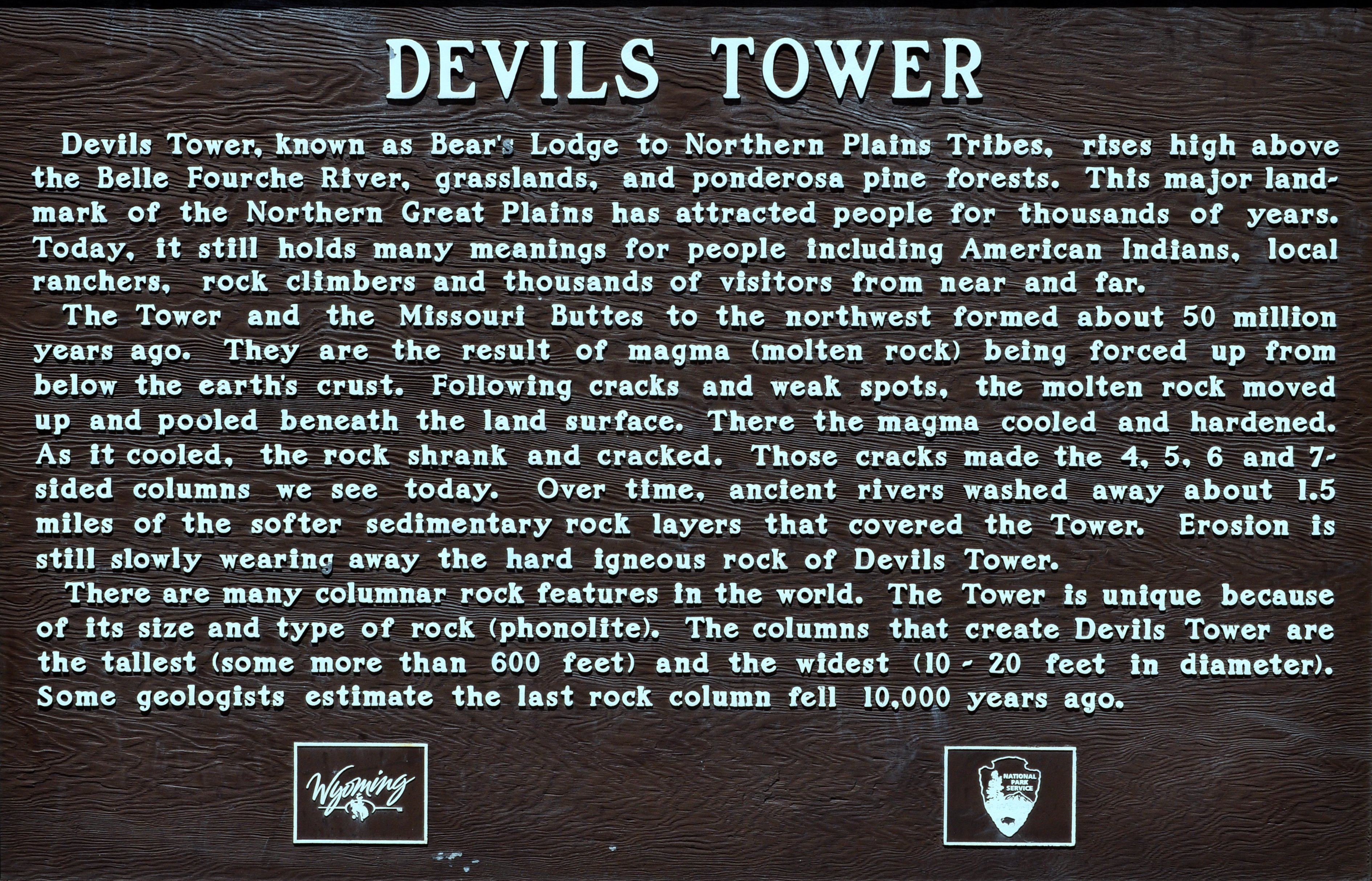
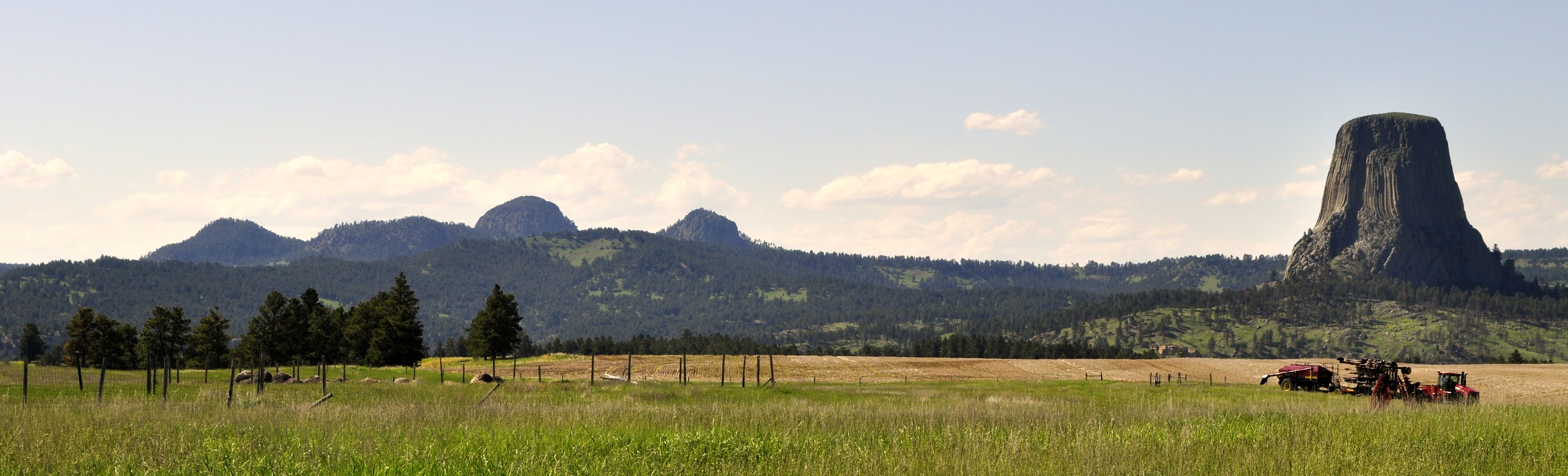
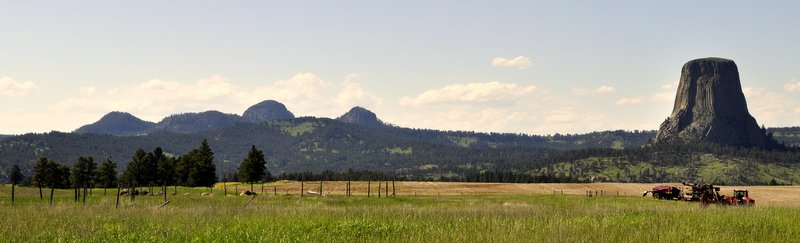
On Day 4, we left the beauty of South Dakota’s Black Hills and headed north through Spearfish Canyon into southeast Wyoming. Our destination? Devil’s Tower, that iconic volcanic plug immortalized in Steven Spielberg’s 1977 movie Close Encounters of the Third Kind.
While our vacation route followed I90 more or less the whole way, we could make diversions from that artery to explore various places that took our fancy. When I was planning our trip way back at the beginning of the year, I discovered that Devil’s Tower, in northeast Wyoming, was a relatively short diversion (in USA road travel terms) north of I90.
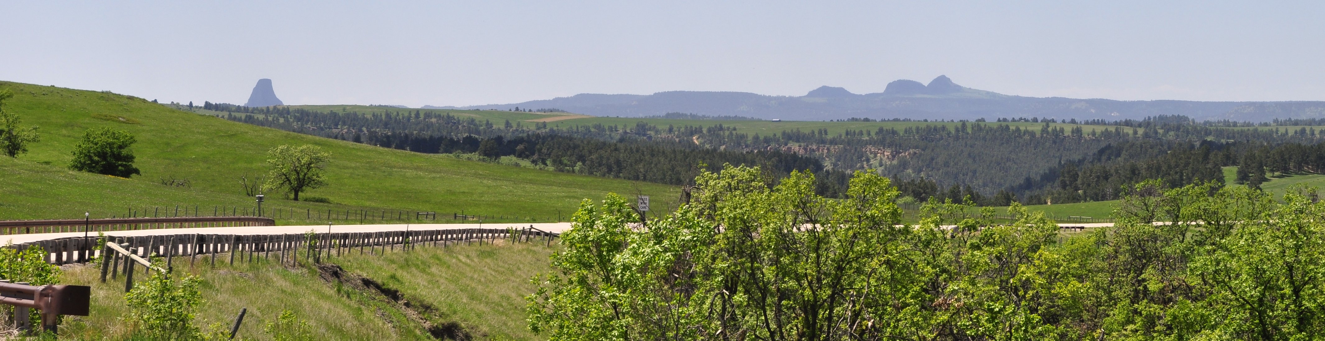
Heading west and cresting a low hill on the undulating plains, there was Devil’s Tower dominating the landscape on the distant horizon. It’s certainly a feature that you can’t mistake for anything else. And as we approached it just seemed to rise up in majesty from the surrounding countryside. This was our first glimpse of the rock, and we pulled into a viewpoint lay-by to have a picnic lunch.
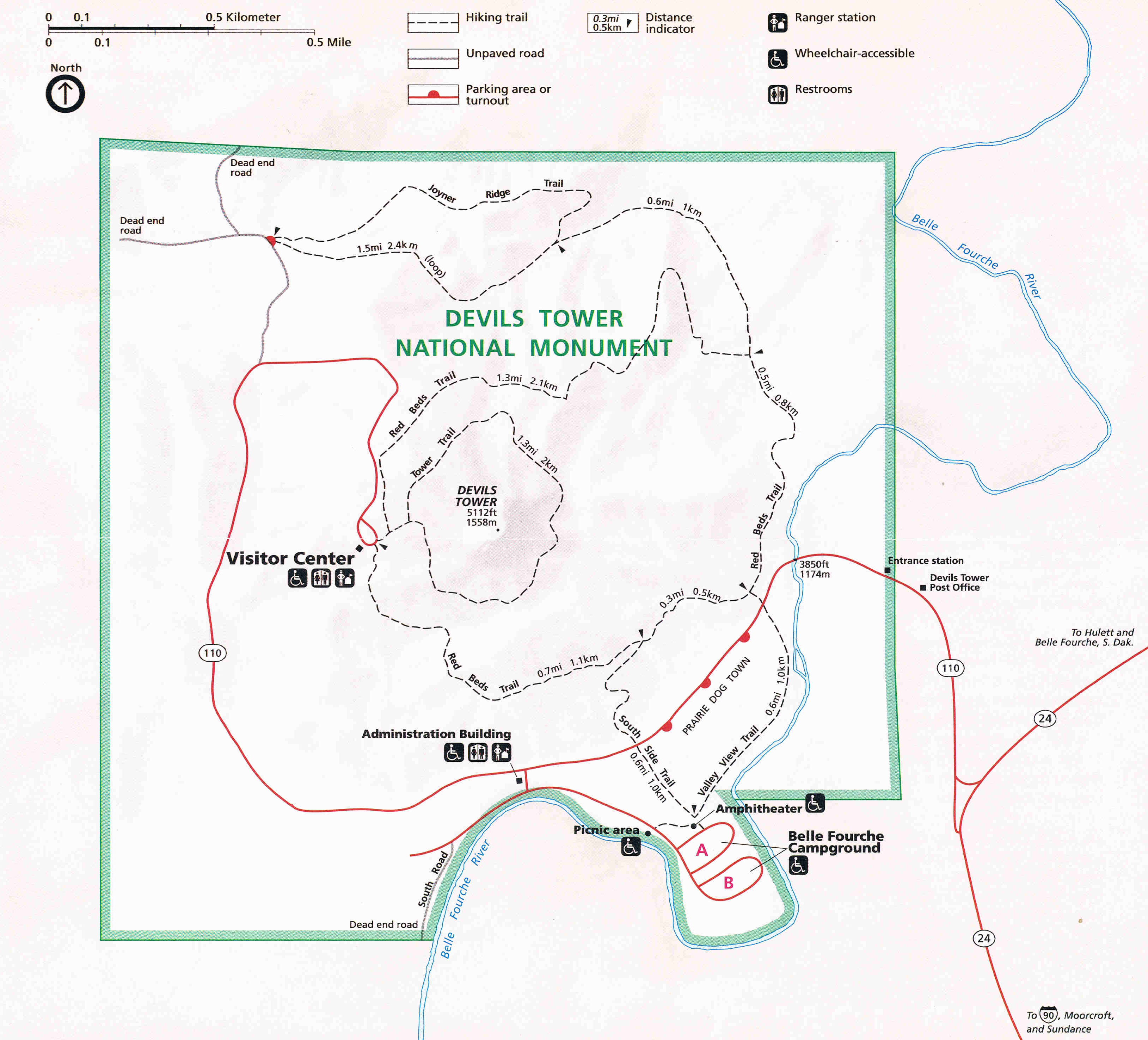
Being a bright sunny day, with hardly a cloud in the sky, Devil’s Tower was quite busy as one might expect, but not as busy as it was likely to become later on in the season once the school-age children were on vacation. Parking, right at the base of the Tower, was easy and plentiful, and it was just a short 100-200 m walk from there to the Tower itself. And somewhat extraordinarily, this is as far as most visitors reached. Steph and me like to get our money’s worth, and decided to circumnavigate Devil’s Tower on the Tower Trail, a walk of about 1½ miles.
Once we were only about 100 m round the south side of the rock, there were hardly no visitors, and we had the place to ourselves. Peace and silence, generally. Just the tweeting of birds in the bushes, and calls of falcons soaring along the sides of the rock itself.
The first national monument in the USA
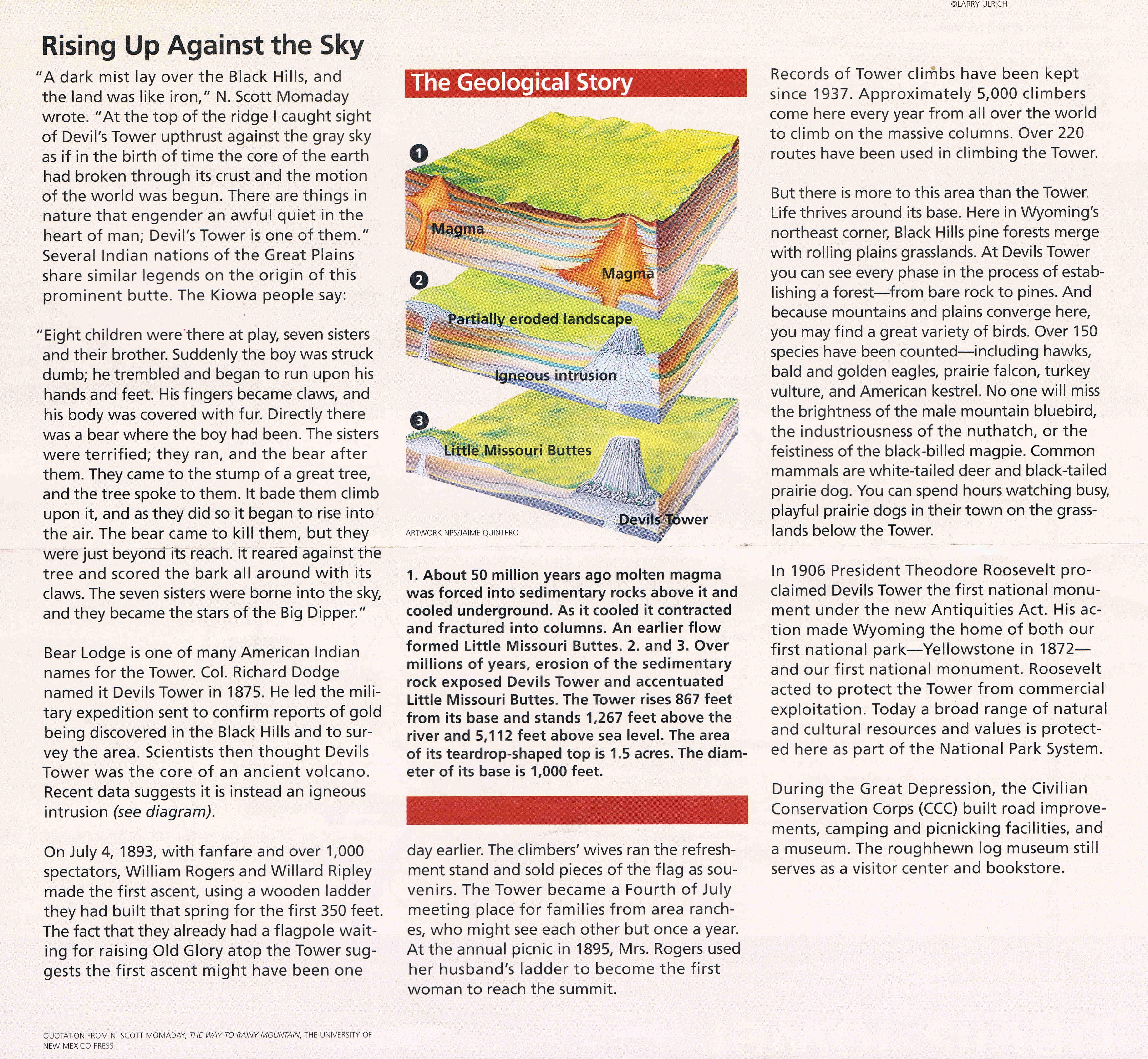
Devil’s Tower is sacred to many Native American tribes, and visitors are requested to respect any artifacts that might have been placed there. In 1906, Devil’s Tower became the first national monument, proclaimed by President Theodore Roosevelt.
I guess we must have left Devil’s Tower around 16:30 after about three hours. Distances can be so deceptive on a road map, and I anticipated it would take about 15 minutes to travel to I90. In fact it was nearer 40 miles. And then when we did reach I90 we discovered that Sheridan (our base for that night) was a further 127 miles! No matter. I put the Kia into cruise mode, and off we headed through some rather bleak terrain (it reminded me of the Pennines in the UK), and one of the world’s largest coalfields near Gillette, WY. But as we descended towards Sheridan, there to the west were the Bighorn Mountains which, at that time, we had not figured on visiting. We changed our itinerary later in the trip, as you can read soon in another post.
Steph and I have just returned from a three-week vacation in the USA to visit Hannah and Michael and grandchildren Callum and Zoë in St Paul, Minnesota (MN). During our vacation, we took the opportunity of driving from St Paul to Yellowstone National Park in Wyoming (WY) – and stops at all interesting places in between in South Dakota (SD) and Montana (MT). While I will post blogs about the various places we did visit, this post is all about the trip as a whole, and hopefully I can provide a few tips for other lucky travelers.
Almost two thousand miles (actually 1,944 miles from our home base in St Paul to our final hotel in Billings, MT) in eight days might seem excessive to some, but in fact it was quite manageable, and we had time to stop – often for several hours – and enjoy the various places we had chosen to visit on the way. Yes, they were long days, but with open roads and little traffic to hold us up, and the judicious use of cruise control on the main highways, I did not feel particularly tired at the end of the day. In any case, relaxing at our hotel with a couple of cold beers always eased away the tiredness. I kept a couple of packs of beers in the car, and placed some each day in the cooler ready for our arrival the hotel in the evening.
We rented a Kia Sorrento SUV from National at MSP, which cost us USD981 (including a one-way drop-off fee of USD250). We spent only USD274 on gasoline – I hate to think how much a similar journey would have cost in the UK.
And to keep in touch with Hannah and Michael, I purchased a 30-day, 10 cents a minute domestic rate SIM card for my mobile from AT&T (20 cents for text messages); 150 minutes cost USD17 incl. taxes. This was a much better deal than I had been able to find online in the UK. So I would certainly recommend anyone traveling to the US to go to one of the big providers like AT&T (with great coverage throughout the country) and purchase one of these simple SIM plans.
We started our journey west on Monday 2 June, and flew back from Billings to MSP on Tuesday 10 June. This was our itinerary.
Day 1. St Paul, MN – Oacoma (Chamberlain), SD via the Minnesota River valley: 367 miles Route
We left Hannah’s around 08:30 and made swift progress for about the first 10 minutes, until we hit morning rush hour traffic on I-494 W, until we reached our turnoff on US-169 south towards Mankato, MN (site of the largest mass execution in US history on 26 December 1862 of 38 Dakota Sioux native Americans) along the Minnesota River valley. Then we joined US-60 southwest to link up with I-90 heading west into SD. One thing we noticed was how poor the road surfaces were in Minnesota, but they improved dramatically once we crossed the state line into SD, and in fact for the rest of our trip through SD, WY and MT.
Our destination was Oacoma, a very small community (essentially a motel, RV park, gas station and shops/restaurant) on the west bank of the Missouri River, just across from Chamberlain. We had a glorious day to travel with hardly a cloud in the sky. Here’s a view of the Missouri in the evening sun.
We stayed at the Oasis Inn, Oacoma (score out of 10 = 6); cost (incl. all taxes): USD106
Day 2. Oacoma – Rapid City, SD, via The Badlands: 231 miles Route The day dawned bright and sunny, but we’d seen a warning on The Weather Channel about storms approaching from the west. So although we started out in bright sunshine, it wasn’t too long – in the heart of the Great Plains – that the clouds rolled in, the sky darkened, and the rain came down in sheets. In fact, at one point I found the nearest scenic overlook to turn off I-90 (not that you could see anything) as driving conditions were getting worse by the minute. We saw lots of lightning strikes in the distance, but never felt the full force of the storm – we skirted the northern edge of a major system that wreaked havoc south and east of us, but which had come down from the northwest where, in Billings, baseball size hailstones had done significant damage.
I really was quite naïve when planning this trip way back last February – I didn’t give the possibility of severe weather a second thought. We were lucky since the various storms (that we avoided) did generate tornadoes and even severe thunderstorms had winds of up to 100 mph. You have to take Mother Nature very seriously out on the Plains – there’s nowhere to hide.
However, by the time we reached the turnoff for the The Badlands, it had stopped raining, the clouds lifted, the sun even came out for a while, and we had an excellent four hour trip through the park.
Then we headed for Rapid City and our hotel, where we spent two nights. We ate the first night at the Golden Phoenix Chinese restaurant (very good) and the second at Shooters Wood Fire Grill, just across the street. I had an excellent steak.
Days Inn, Rapid City (7); cost: USD168
Day 3. Mt Rushmore National Memorial and Custer State Park, returning to Rapid City for a second night: 119 miles Route Steph and I both wondered what Mt Rushmore would be like, kitsch or not. And that concern was reinforced on the drive up into the Black Hills from Rapid City – all the many tourist attractions along the highway, and in Keystone, a small community closest to Mt Rushmore. My earliest recollection of Mt Rushmore was in Hitchcock’s North by Northwest (with Cary Grant, James Mason, and Eva Marie Saint).
In fact, Mt Rushmore was very moving and inspiring, we couldn’t have asked for better weather, the cliff-face carvings emphasized by a brilliant blue sky. Then we moved on to Custer State Park south of Mt Rushmore and took our time meandering along the park highways, and through a series of extremely narrow tunnels carved through the hillsides. No RVs here!
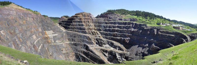
Day 4. Rapid City, SD to Sheridan, WY via The Black Hills, Spearfish Canyon, and Devil’s Tower: 300 miles Route We spent the morning working our way north through the beautiful Black Hills of Dakota and stopped in Lead (as in ‘seed’) to view the huge crater of a former gold mine.
It was the discovery of gold in the Black Hills in about 1870 that exacerbated the conflicts with native Americans. Less than five miles from Lead is Deadwood (of Calamity Jane fame, and the stage), but when we reached the fork on the road junction we turned left to Lead. I regret not turning right and visiting Deadwood because of all its historical connections.
Then we headed north and west to Devil’s Tower, the first site to be declared a national monument, by President Theodore Roosevelt in 1906. Iconic Devil’s Tower featured in Steven Spielberg’s 1977 classic Close Encounters of the Third Kind, and I’d promised myself after seeing the film that I would visit it if I ever had the chance. And I wasn’t disappointed.
Departing Devil’s Tower at about 4 pm, we thought the drive to Sheridan wouldn’t take too long. In fact it was 33 miles to I-90, then, to our surprise (and consternation) we saw that it was still 127 miles to Sheridan! Still, we had a good meal at Sanford’s Pub and Grub.
Rodeway Inn & Suites, Sheridan (4); cost: USD93 (in fact, they couldn’t find our reservation. I should have walked away then and found another hotel but after a long drive I was too tired. The room could have done with a more rigorous going-over with the vacuum cleaner).
Day 5. Sheridan to Red Lodge, MT via the Little Bighorn Battlefield: 222 miles Route
This was a big day for me. It dawned overcast and drizzling, with very low cloud, and rather cool compared to the previous days. But as an aficionado of westerns, and I’ve also read quite a bit about the European expansion west during the 19th century, I was intrigued to visit the site of Custer’s Last Stand (I’m currently reading a fascinating account of Custer and Crazy Horse by American author Stephen Ambrose).
There was an interesting display of artifacts in the visitor center, but what I found particularly moving were the marker stones scattered across the battlefield indicating where both US soldiers and native Americans had fallen defending their way of life. And the native American memorial is stunning. But more of this in another separate post.
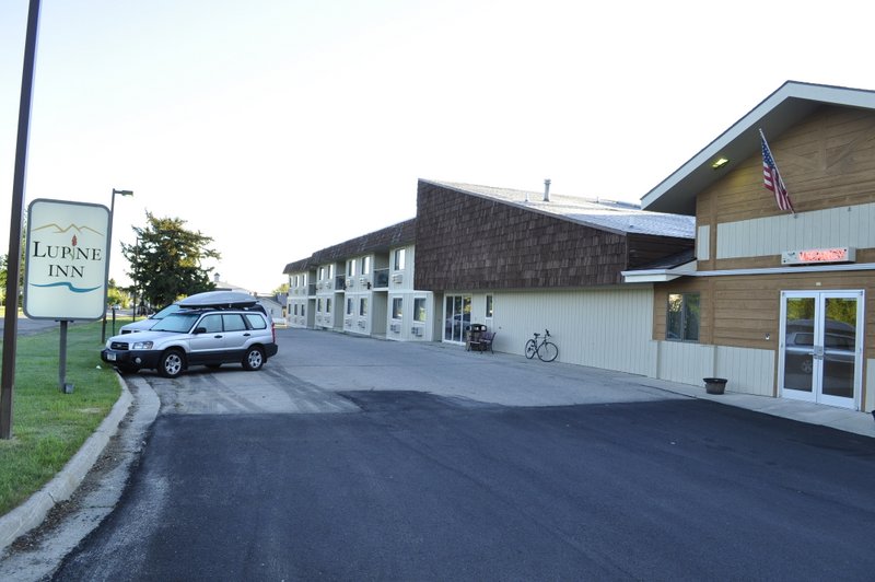
We stayed this night in Red Lodge, just north of Yellowstone National Park. We had a great pizza at the Red Lodge Pizza Co. on South Broadway Ave.
Lupine Inn, Red Lodge (8); cost: USD88
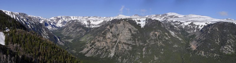
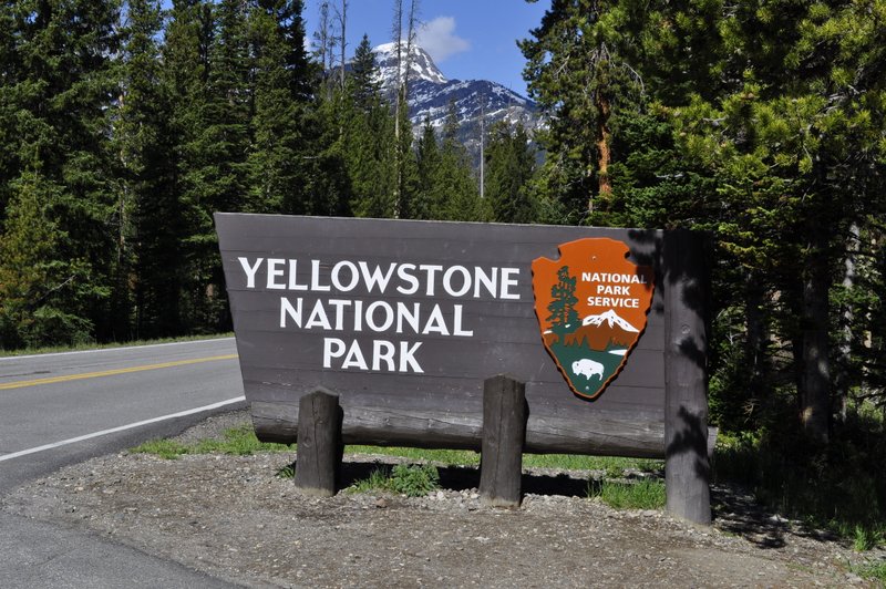
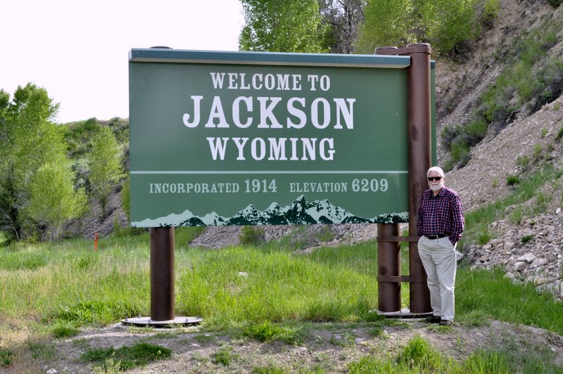
Day 6. Red Lodge to Jackson, WY via the Beartooth Highway, and Yellowstone and Grand Teton National Parks: 228 miles Route When planning our trip I had no idea of what to expect in traveling into Yellowstone via the northeast gate from Red Lodge. The Beartooth Highway climbs – almost vertically – right over the top of the Beartooth Mountains, and usually remains closed until the end of May when the snow clears. It was a stunning drive.
Yellowstone was both exhilarating – and a disappointment.
There are quite long stretches traveling between tall pine tress, so there’s not much to see. And I guess we have all be spoiled by the amazing wildlife images on TV. While we did see herds of bison, and a few elk, wildlife was not generally conspicuous. I hate to think what then park would be like at the height of the summer season. Bumper to bumper no doubt. Even during our visit we encountered some traffic jams as folks frantically looked for somewhere to pull over to take yet another photo of a lonely bison.
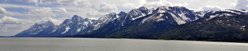
The Tetons are something else. Along Jackson Lake, which lies at just over 6,000 feet, the mountains just rise vertically another 6,000 feet or so. Our destination was Jackson – a winter sports venue for the rich and famous.
Anglers Inn, Jackson (9); cost USD119 (breakfast not included – so we had had the pleasure of that great American tradition: going out for breakfast on the Sunday morning at The Bunnery).
Day 7. Jackson to Cody, WY via Grand Teton and Yellowstone National Parks (Old Faithful): 233 miles Route
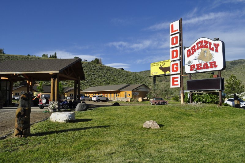
We traveled north back into Yellowstone to visit all the hot spring and geyser sites, including Old Faithful. I almost dubbed it ‘Old Faithless’ because we had to wait about 20 minutes longer than expected for it to do its stuff. I say ‘we’ – us and about 500 others. This was no doubt the most crowded part of the park that we visited, but everywhere else we were able to stop, take our time, and take all the photos and video we wanted. Late in the afternoon we headed towards the east entrance to Yellowstone down the highway to Cody – ‘the rodeo capital of the world’, and founded by ‘Buffalo Bill’ Cody. Cody lies about 70 miles east of Yellowstone. We had made hotel reservations outside the national park – at Red Lodge, Jackson, and Cody – and even with having to retrace our steps we decided it was worth it. However, we discovered that the road to the Yellowstone north entrance was being repaired, and significant traffic delays were being reported. So rather than traveling back from Cody to Yellowstone on the last day, we decided to head east.
Grizzly Bear Lodge, Cody (7); cost: USD97
We had dinner at the Proud Cut Saloon, and although the service was rather slow – and I did complain – the flatiron steak I had was one of the best steaks I’ve eaten in a long while.
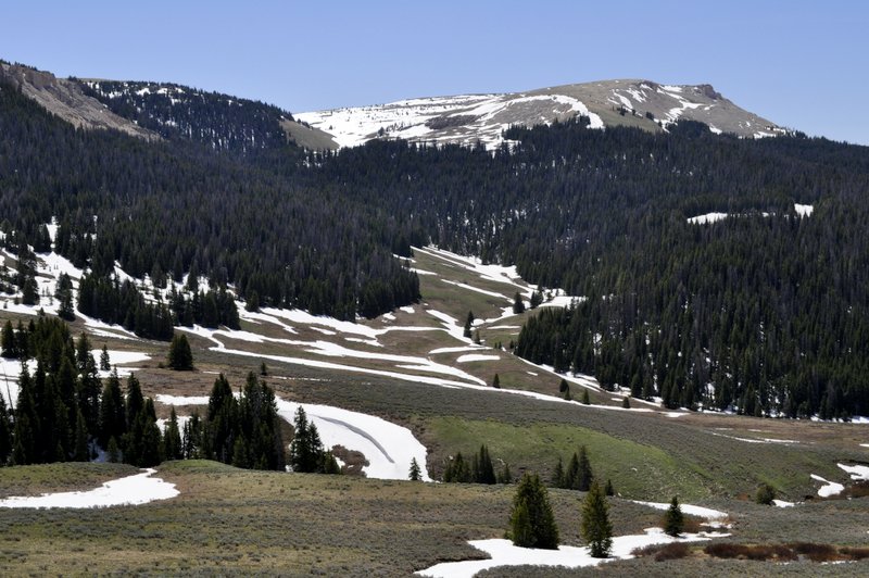
Day 8. Cody to Billings, MT via the Bighorn Mountains: 244 miles Route And what a smart decision that was, not to travel back into Yellowstone. Instead we headed east into the Bighorn Mountains – and would have reached Sheridan again if we had not turned east again, and then north towards our final destination, Billings.
The Bighorn Mountains rise out of the high plains. On the descent there was a 10% gradient for over 12 miles; sometimes it felt as though we would fall over the edge of the earth. Our hotel in Billings was conveniently located close to the airport. We had a reasonable meal at the local Applebees beside the hotel.
Boothill Inn and Suites, Billings (9); cost: USD128
We spent USD86 on entrance fees to the various national and state parks and national monuments – an exceptionally good deal, since the entrance fee often covers multiple visits over a three to seven day period. Just what we needed for our Yellowstone visit. And the formation brochures that are provided by the National Park Service are excellent. I don’t think we spent more than about USD350 on meals. Each day (except one) we had breakfast (such as it was) in the hotel, and had sandwiches for lunch (or left-overs from the previous night’s meal) supplemented by a yoghurt and a piece of fruit (often filched from the breakfast bar), and a handful of delicious Trader Joe’s Veggie & Flaxseed Tortilla Chips. The evening meal was the ‘expensive’ part of the day, and it was always possible to find somewhere good to eat and not expensive. Not a journey exactly on a shoestring, but not super expensive either.
A long journey, but a great experience. Of course there are so many more details to fill in, and these will be the topics I’ll address in a range of blog posts over the coming weeks.
Early in 2011, Steph and I began to plan our next visit to Minnesota to visit daughter Hannah, husband Michael, and grandson Callum, scheduled for May when Callum would be around nine months, and almost at the crawling stage.
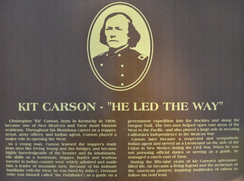
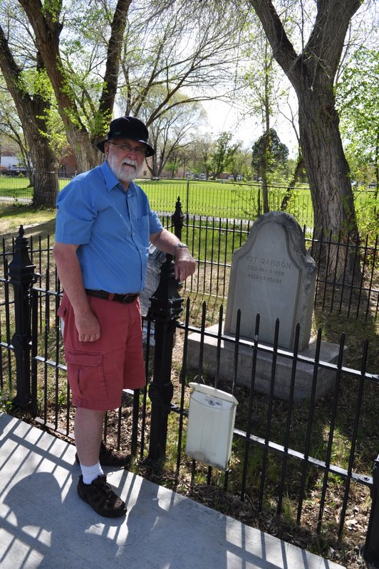
I suggested that we should take the opportunity of being in the US to fulfil one of our long-held ambitions, namely to visit the Grand Canyon. Well, as chance would have it, I’d been reading a biography of 19th century frontiersman and Indian agent and fighter, Kit Carson. And I discovered that much of his life had been spent in northern Arizona and north-west New Mexico. This got me thinking. Why not combine a visit to the Grand Canyon to a number of the sites mentioned in the book I’d been reading? And so we planned an itinerary that would take in the Grand Canyon, Monument Valley, the Canyon de Chelly (pronounced shay), the Petrified Forest National Park and the Painted Desert in Arizona, and the mountains of north-west New Mexico, including the Rio Grande gorge, and the mountains near Los Alamos, where the first atomic bomb was assembled. During our trip we visited Carson’s grave in Taos, NM.
The grave of Kit Carson in Taos, NM
Click on the images below to view various web albums.
After spending a few days chez Foldes in St Paul, we flew to Phoenix, AZ and drove up to Flagstaff via the Sedona Valley. This was our first introduction to canyon country, red buttes and all. After an overnight stop in Flagstaff (where it began to snow!), we headed north via the Sunset Crater National Park and Wupatki National Monument (a series of Pueblo Indian settlements in the desert) to reach the Grand Canyon.
Words cannot describe the awesome spectacle as you gaze over the canyon for the first time at Desert View (just after entering the Grand Canyon National Park).
We spent a couple of nights at Grand Canyon Village, in very comfortable motel-style accommodation. Since it was the beginning of May (and even though the various hotels/motels were full), the area was not heaving with tourists. On the second full day there, we took the bus on the crater rim route to the west, getting down after a couple of stops, and walking a few kilometres along the rim – literally just a meter or so from a sheer drop to the canyon floor below. Not for the faint-hearted! Now I’m haven’t got the best of heads for heights, and at one viewpoint, with sheer drops on three sides, and just a narrow neck of path to walk along, my legs went to jelly. And since it was also rather windy, I began to doubt whether I could overcome my feeling of helplessness, and actually make it to the end, and look over and around. I sat down, and told myself not to be so silly, that having come all this distance, it would be silly to let a little vertigo get in the way of enjoying some spectacular vistas. It took about 10 minutes, but eventually I made my way gingerly to the guard rail, and after that, I had little difficulty in standing on the edge. For much of the crater rim walk, there were no safety rails, and so I just concentrated on looking ahead at the path, and not over the lip.
Too soon our Grand Canyon visit was over, and we headed east and north to Monument Valley, which straddles the Arizona-Utah state line, and which was used by film director John Ford on several occasions as the location for films such as Stagecoach, The Searchers, and She Wore a Yellow Ribbon, all starring John Wayne. Monument Valley is iconic mesa and butte country, owned by the Navajo Nation. We were able to drive through the valley, and saw very few other cars. We had been advised to get to the valley as early as possible because of potential tourist congestion, but that just wasn’t a problem for us. Maybe a few weeks later, once the grade schools were on vacation, the situation would have been very different. But in mid-May and throughout our whole trip, we saw very few tourists.
Canyon de Chelly is a magical and mystical place, and although the canyon itself is not as deep or wide, Steph and I actually preferred this to the Grand Canyon. It was much more intimate, so-to-speak, and still occupied and farmed by the Navajo. At a number of places throughout the canyon there are ancient ruins of settlements. There were fantastic viewpoints at several sites on the north and south sides of the canyon, and spectacular views of Spider Rock. Canyon de Chelly was the site of several massacres of the Navajo in past centuries – by the Spanish, and later in the 19th century, by the US government. The sides of the canyon are sheer, often dropping 1,000 feet straight down to the canyon floor. Had I not read the Carson biography I would never have dreamt of visiting Canyon de Chelly, which was certainly for me the highlight of the vacation.
We drove south to the Painted Desert and the Petrified Forest National Park. The Painted Desert has to be seen to be believed – I’ve never seen horizontal sedimentary layers like these, all banded in different colours.
We then headed north-east, and into New Mexico. Time was pushing on, and although we passed close by, were were unable to visit Shiprock or the Four Corners (where Arizona, Utah, Colorado and New Mexico meet).
Heading over the mountains in north-west New Mexico, we dropped down to the Rio Grande and Taos, and then headed south towards Albuquerque, and up into the Valles Caldera. Quite often we saw road signs indicating possible congestion on the road ahead, but in all our 1,200 miles over eight days we never encountered any hold-ups. In fact sometimes we drove for an hour or more without seeing another vehicle.
All too soon our holiday in the southwest was over and we flew back to St Paul to enjoy several more days with Callum.
Here is our route in two maps:
Phoenix – Flagstaff – Grand Canyon – Monument Valley – Canyon de Chelly (route)


 - Transferred from en.wikipedia(Original text : self-made), CC BY-SA 3.0, https://commons.wikimedia.org/w/index.php?curid=3732878")


 I’m a bit of a news junkie, so I’ve been avidly following presidential election campaigns in three countries in online newspapers and on social media.
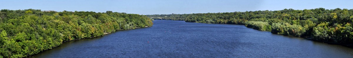


 It was a Tuesday morning, early June. We’d reached Chamberlain, South Dakota on the banks of the Missouri River the evening before, having traveled down from St Paul, MN in glorious sunshine. To the west, however, there was an ominous glower in the sky that was already beginning to darken by breakfast-time. Checking the Weather Channel we learned to expect some thunderstorms as we crossed the Great Plains towards our next destination: