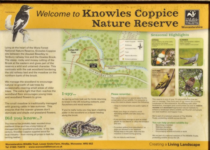
Kernow a’gas dynergh – Welcome to Cornwall (3): Stepping back in time

Almost 2000 years.

English Heritage preserves several important sites in Cornwall, and during our week long break there, we got to visit four that span about 2000 years of British history, from the Roman occupation of these islands, through the Dark Ages, the 12th century under the Normans, and from the Tudors until the Second World War:

  • Chysauster Ancient Village, on the Land’s End Peninsula
  • Tintagel Castle, on Cornwall’s north coast
  • Restormel Castle, near Bodmin
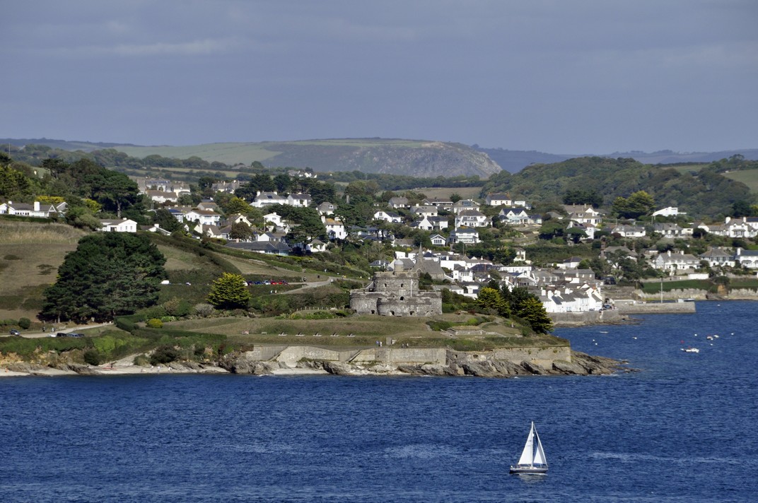
  • Pendennis Castle, overlooking Carrick Roads near Falmouth

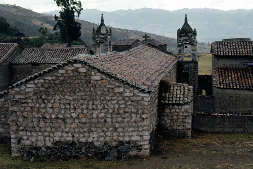
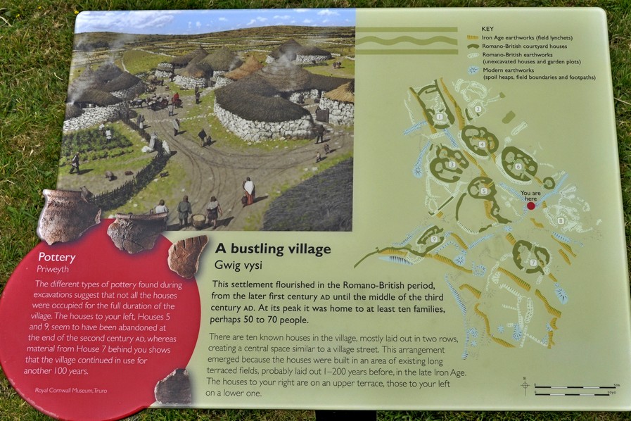
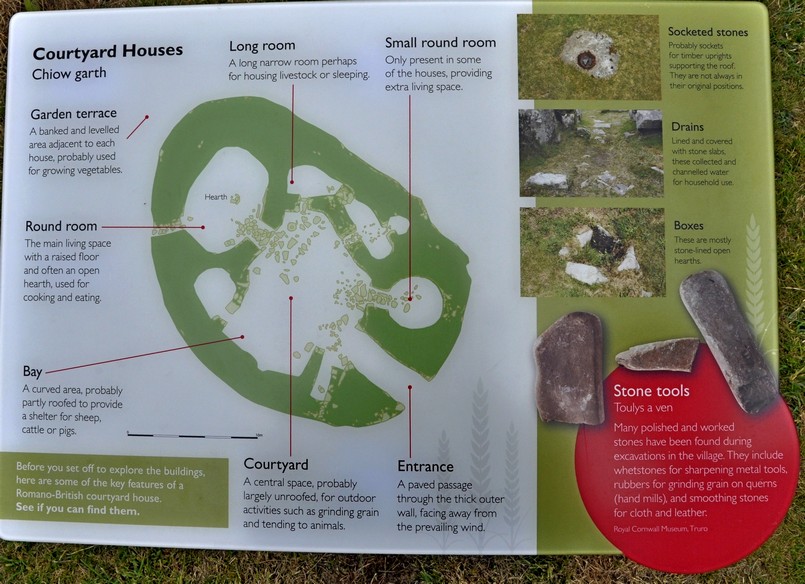
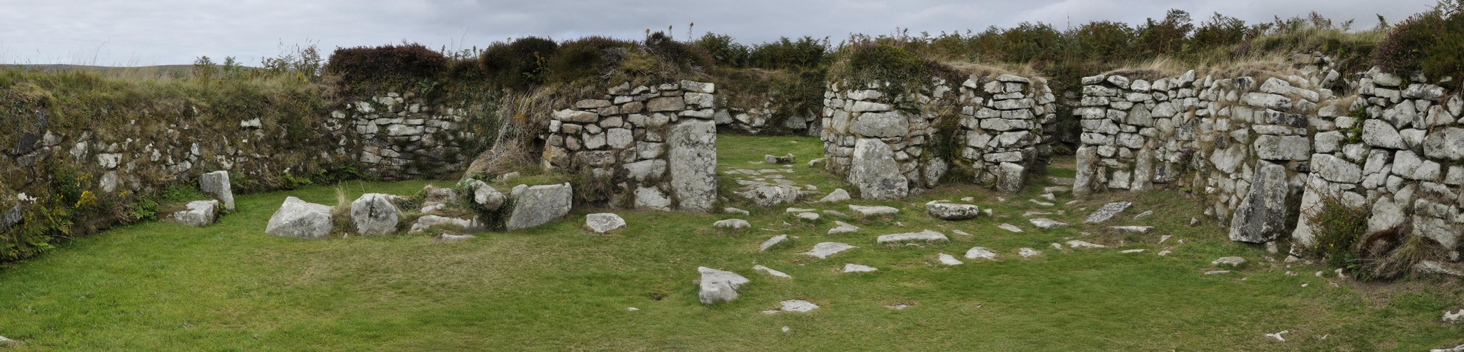
Chysauster Ancient Village (pronounced ‘chy-soyster’, with ‘ch’ as in church)
Sylvester’s House. That’s what Chysauster means; ‘chy’ is Cornish for house or home. But whether Sylvester ever lived there and who he was I guess we’ll never know. Because the remains of this Iron Age village date from Romano-British times, some 1800-2000 years ago.

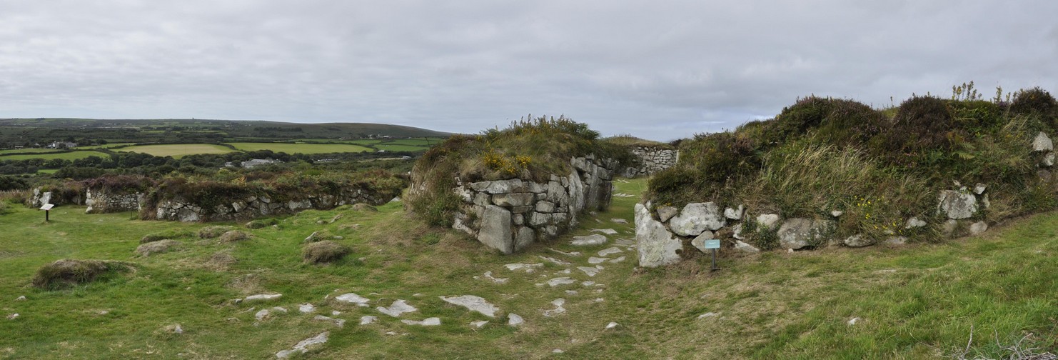
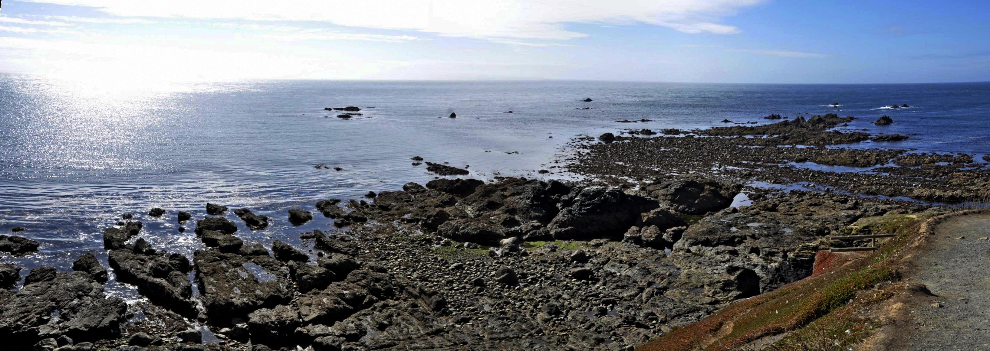
The Romans never really penetrated into Cornwall, apparently. Thus Chysauster, with its unique courtyard houses (found only in Cornwall and the Scilly Isles), is a very important site in the nation’s history. Courtyard houses are found in several locations, but the village at Chysauster is one of the best preserved.

As I walked on to the site I had this feeling that the village had once been a thriving community. I could imagine children playing among the houses, smoke rising from each roof. A busy place.

We spent about an hour walking from one building to the next, fascinated by the layout of each house with its rooms off the central courtyard, and even a backdoor.

Take a look at more photos here. This is the link to English Heritage.


Tintagel Castle
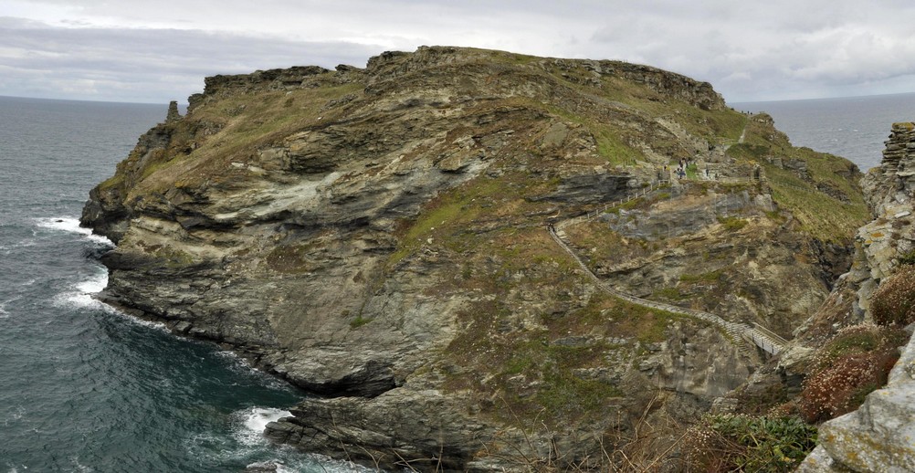
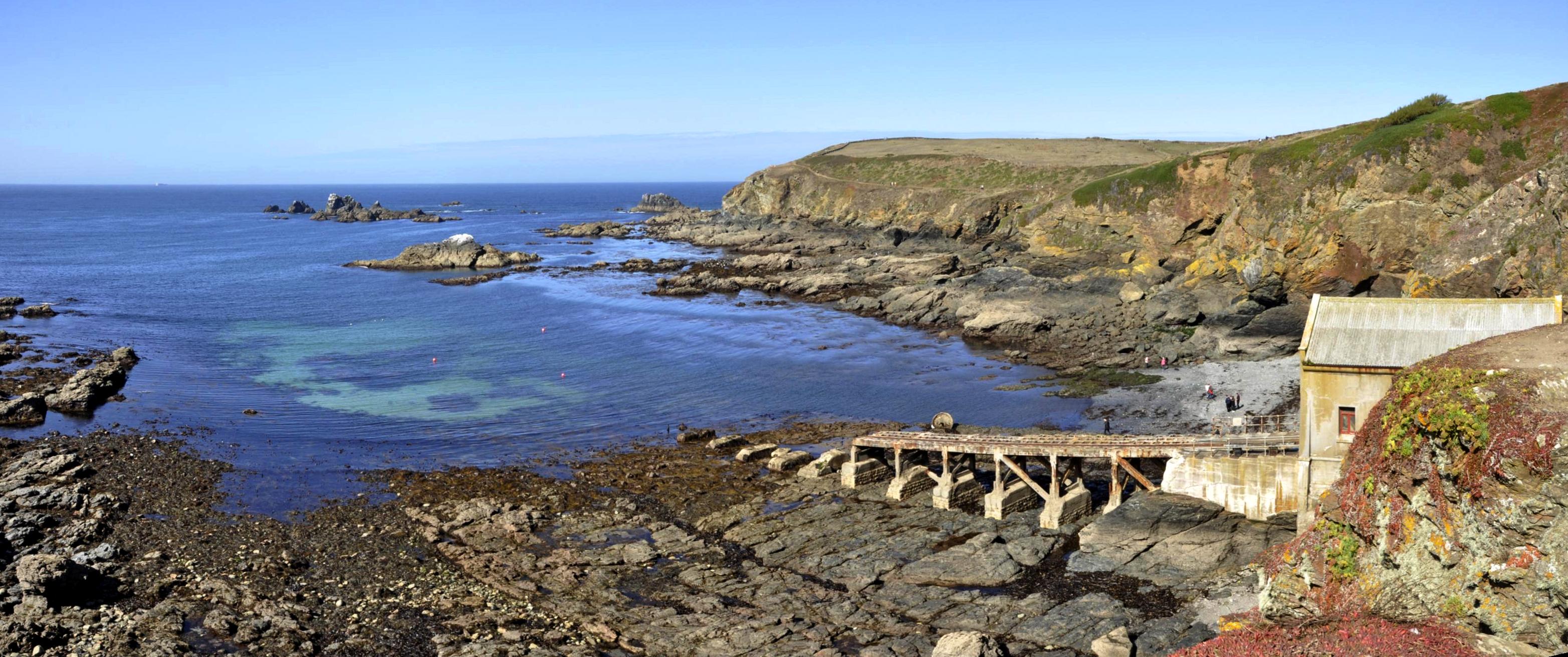
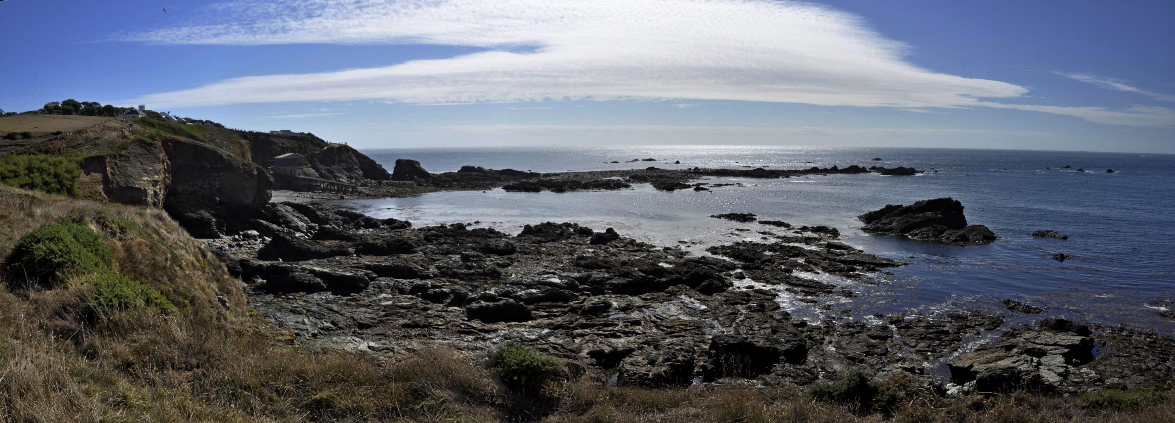
Did King Arthur live here? Did he even exist? Whatever the truth of the myth, Tintagel Castle will forever be linked with his name. It’s certainly an iconic site jutting out into the North Atlantic, battered constantly by winds and storms. It was quite windy on the day of our visit, but thankfully dry.

Tintagel Castle from the Upper Mainland Courtyard (4)

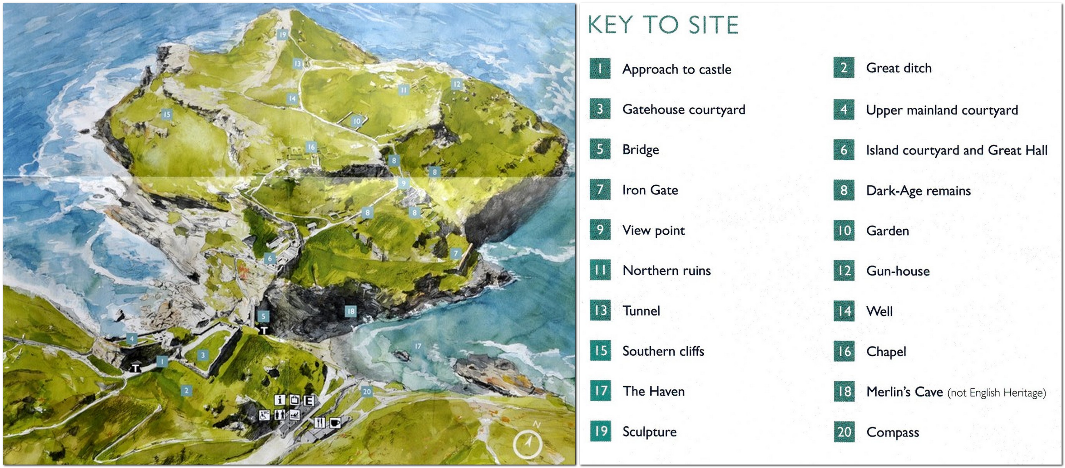
Click here to download a phased plan of the castle, which shows its occupation over almost a thousand years.

Geoffrey of Monmouth has a lot to answer for, because much of what we ‘know’ of our history prior to the 12th century is a mixture of fact and fiction that he wrote in his History of the Kings of Britain.

Among the many myths that he conjured up is the tale of King Arthur and his links with Tintagel Castle where, claimed Geoffrey, Arthur was conceived.

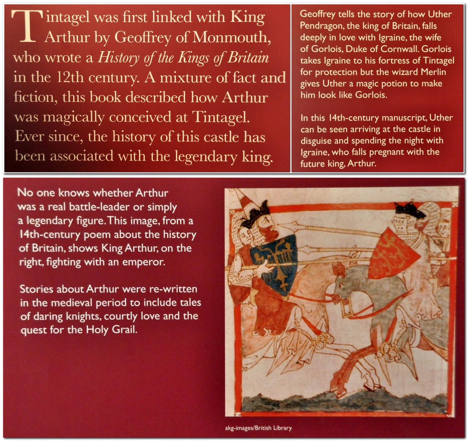
Tintagel Castle was once home to a thriving community of more than 300 persons. But since much of its history derives from the so-called Dark Ages (the period between the exodus of the Romans in the 5th century AD and the arrival of the Normans in the 11th). Tintagel Castle island is dotted with the remains of many houses.

We arrived at Tintagel just before 09:30. I wanted to be sure of a parking place knowing that it can become very busy. The castle opened at 10:00, so we took a slow walk down to the entrance, about half a mile, and quite steep in places. We opted for the Land Rover ride (at £2 each) back up to the car park after our visit.

The cafe was just opening, so we enjoyed a quick coffee before registering for our visit, and getting some wise advice about how to tackle the site. There are lots (and I mean lots) of steps at Tintagel, some very steep indeed. The person on the ticket counter advised us to enter the site through the upper entrance (just before 1), and straight into the mainland courtyards (3 and 4) that overlook the main entrance and island courtyard and Great Hall (6).

There is a set of extremely steep steps down the cliff to then cross a bridge and climb into the main ruins. The walk up to the upper entrance and courtyards was certainly gentler than had we visited the main island first then returned to view the courtyards (and climb that set of stairs) as we saw many other visitors doing later one. And by visiting the courtyards first, we had a panorama over the island ruins to get our bearings.

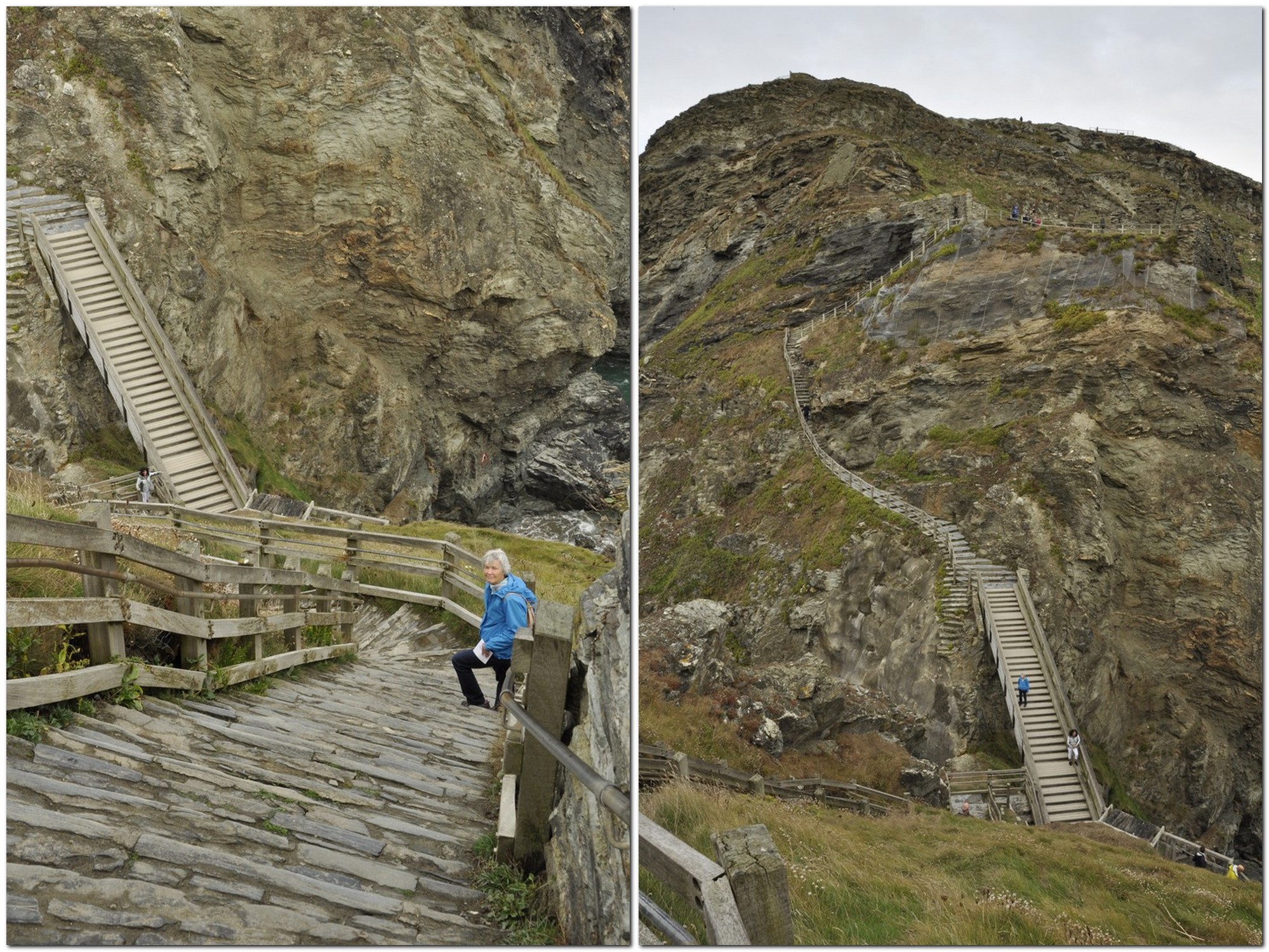
What goes down must go up . . .

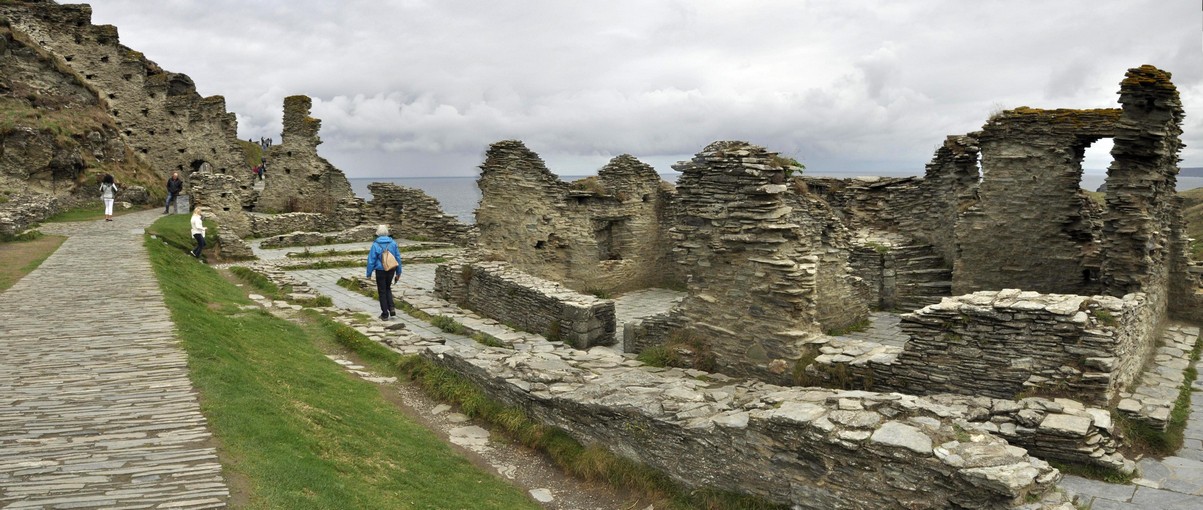
The island courtyard and Great Hall (6)

Check out the full album of photographs. It takes about an hour and a half to walk round the ruins and appreciate everything that Tintagel has to offer. The views over the cliffs, north and south down the coast are typical Cornwall, and you’re left wondering how a community managed to survive for so long in this rather desolate spot.
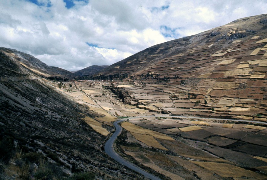
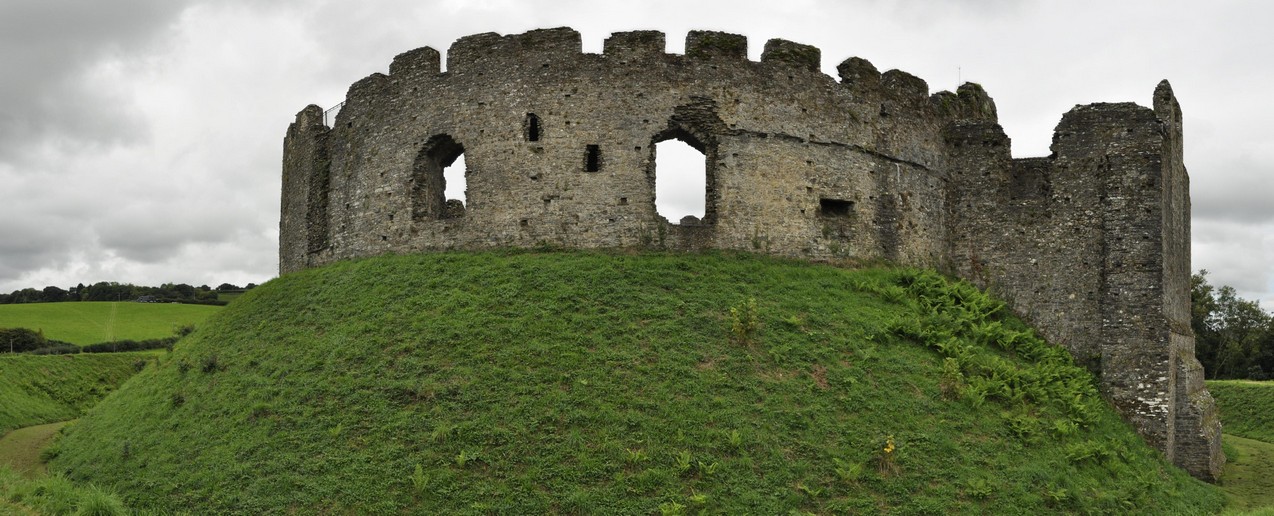
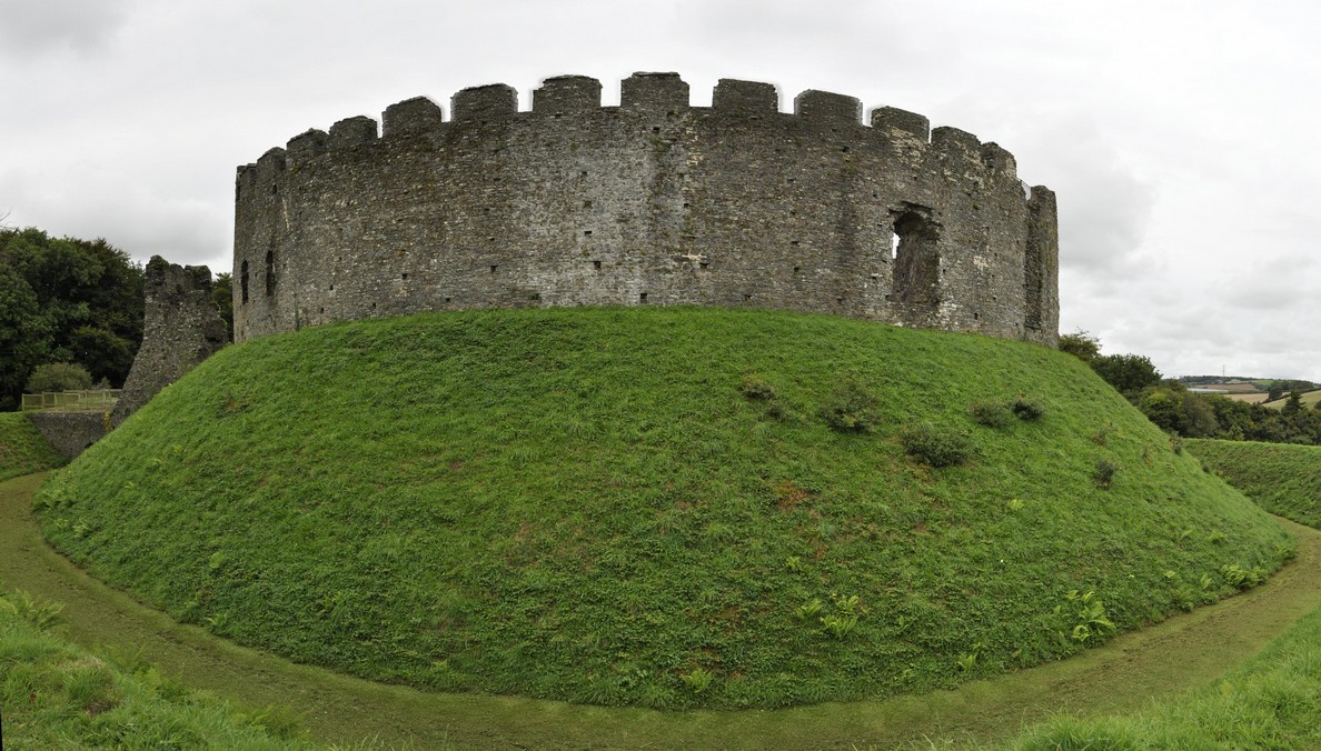
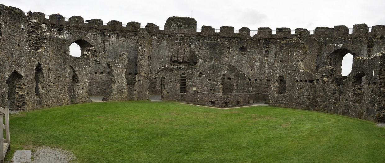
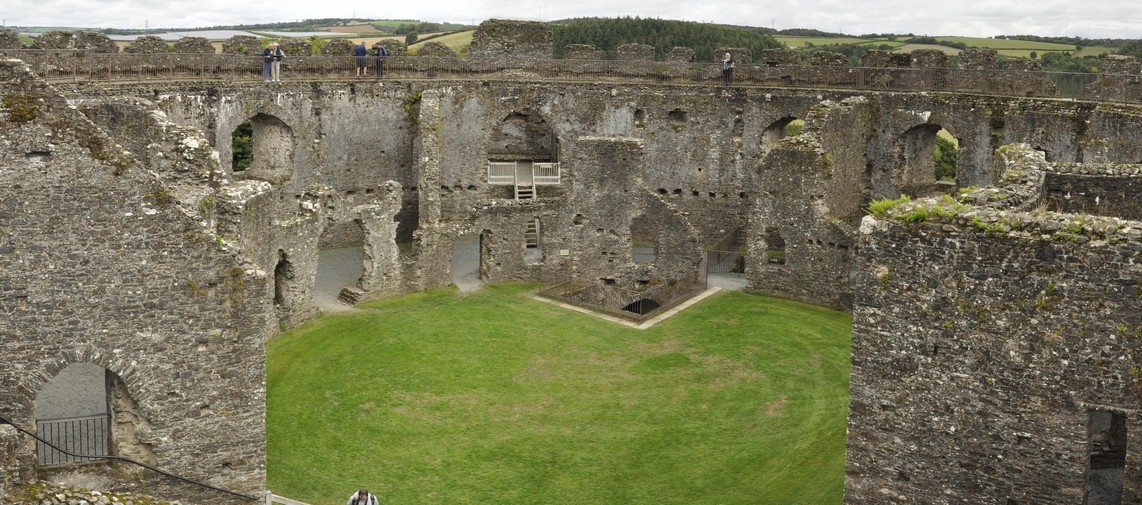
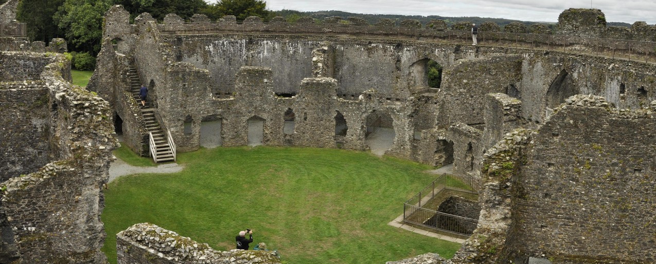

Restormel Castle
Moving forward to the 12th century, Restormel is a Norman castle alongside the River Fowey in Lostwithiel. Its circular shell keep is unusual (the round tower at Windsor Castle is also a shell keep), built on a mound surrounded by a dry (and quite deep) ditch. The ruins are remarkably well preserved, and in addition to wandering through the various rooms at ground level, English Heritage has provided access to the battlements, from which there is a good panoramic view over the surrounding countryside.

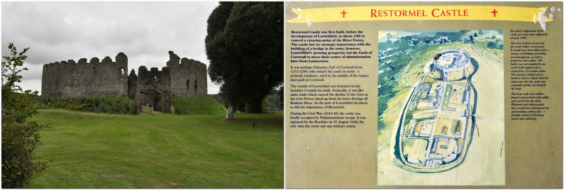
You can read a detailed history of Restormel here.
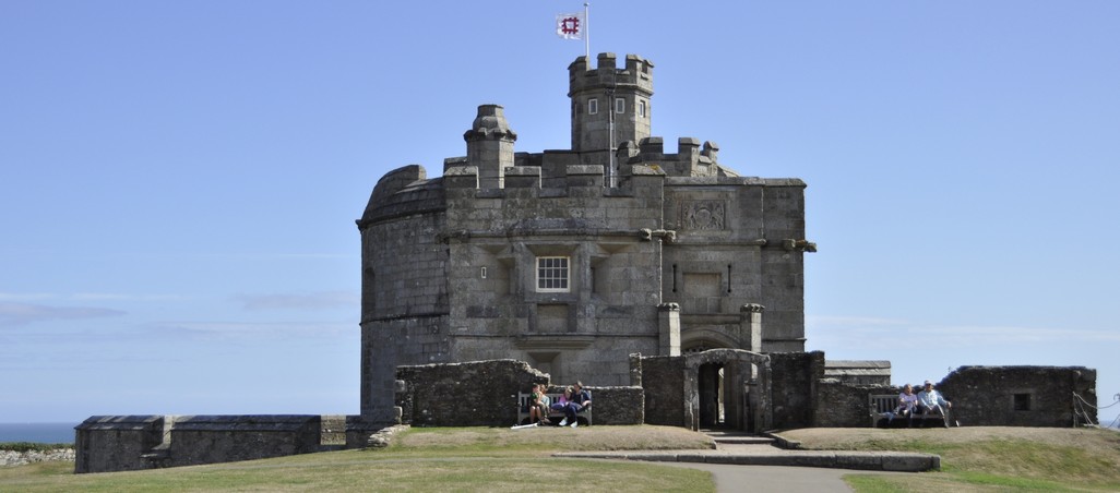
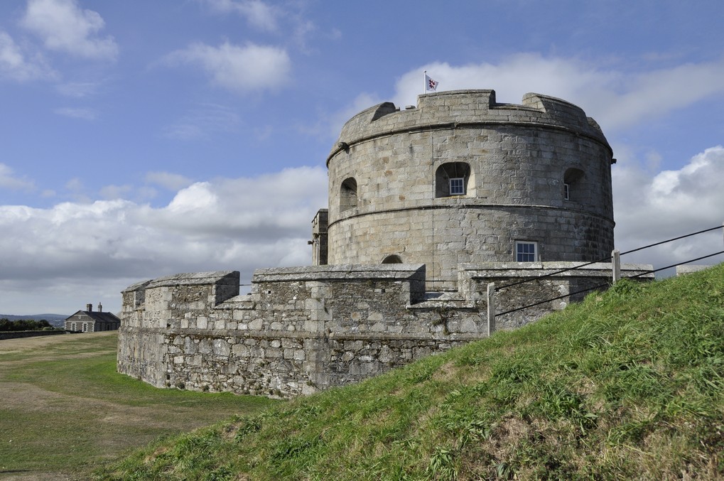
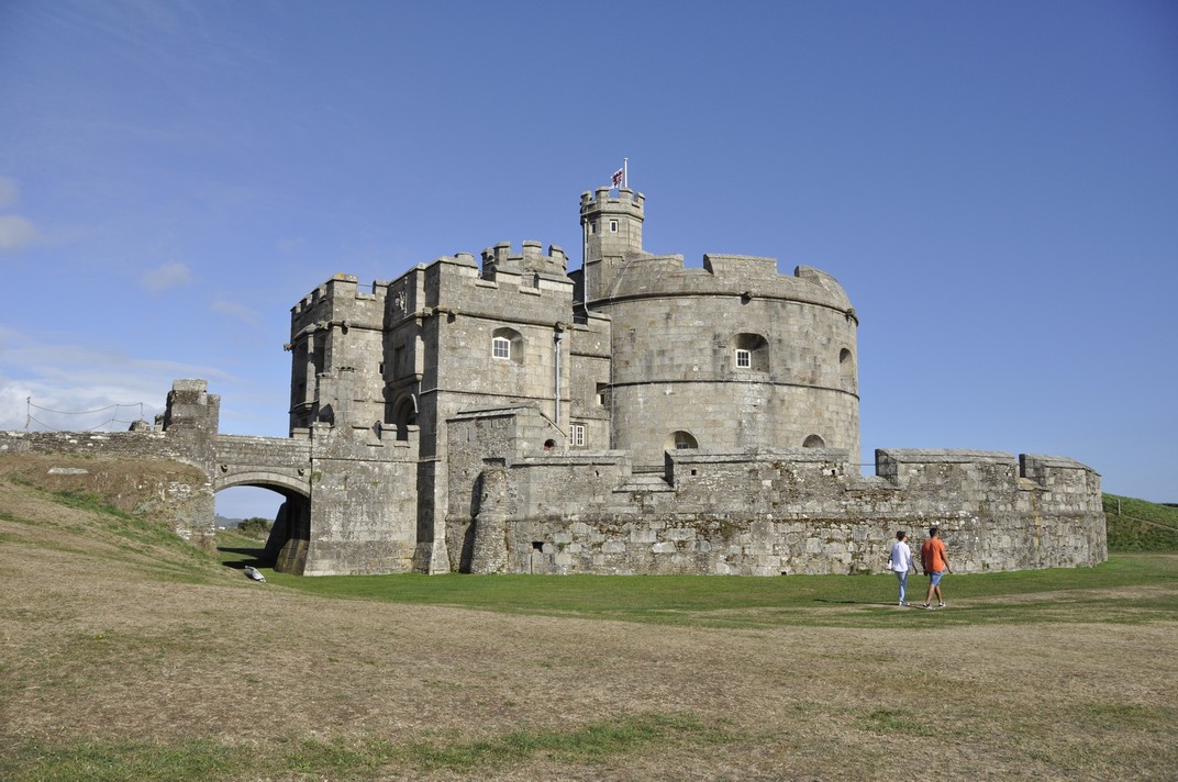

Pendennis Castle
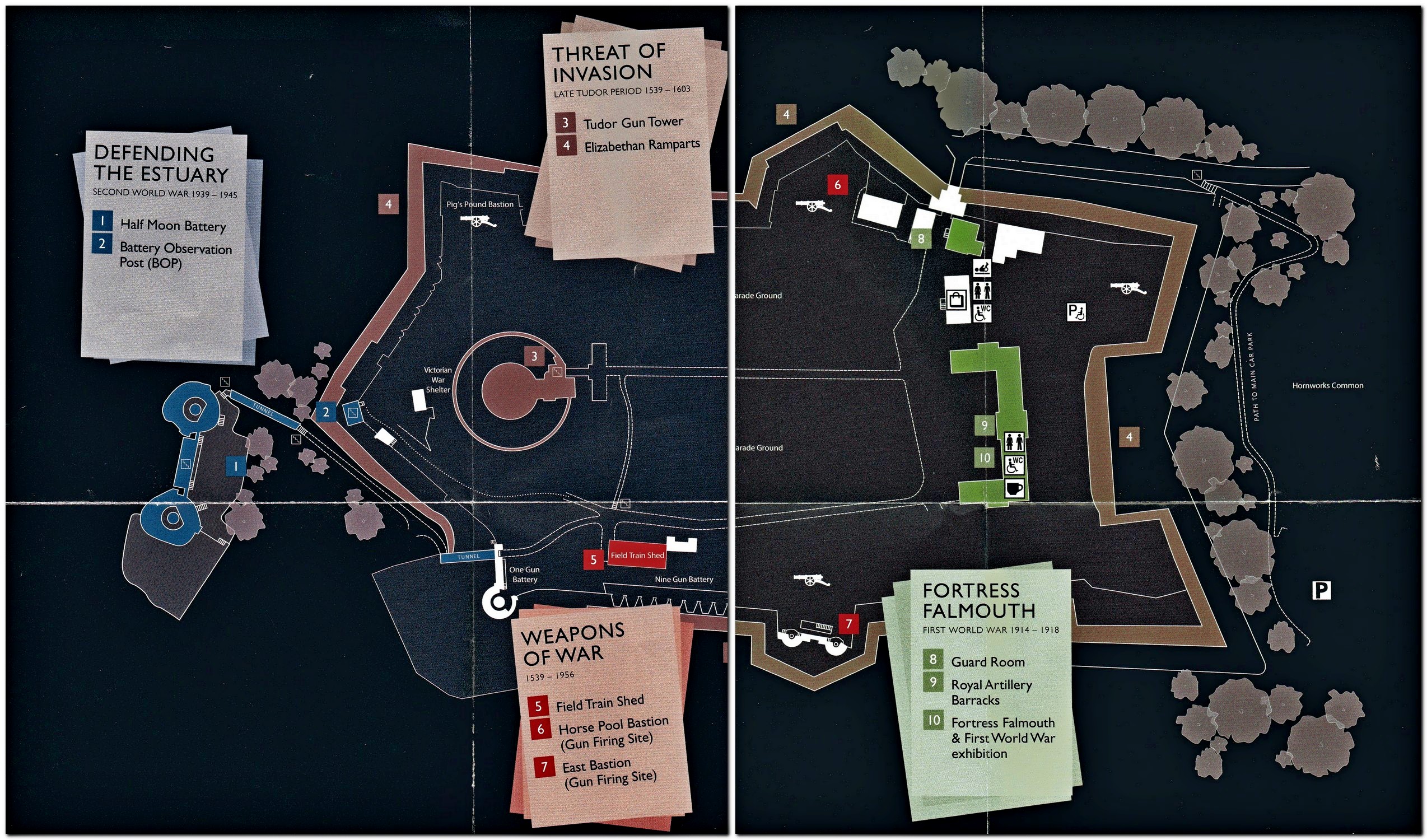
Guarding the approaches to Falmouth, Pendennis Castle has proudly stood on a peninsula overlooking Carrick Roads since the time of Henry VIII in the sixteenth century. And it remained an important fortress right up to the Second World War when guns were installed to combat any threat from German naval vessels.

Across the estuary is another Tudor fortress, St Mawes Castle, a mirror image of Pendennis. During Tudor times, the guns from each could reach half way across the estuary, this protecting Falmouth and its harbor from both sides.

In July 2016 we visited Calshot Castle, that guards the approaches to The Solent near Southampton, and is another of Henry VIII’s coastal fortresses.

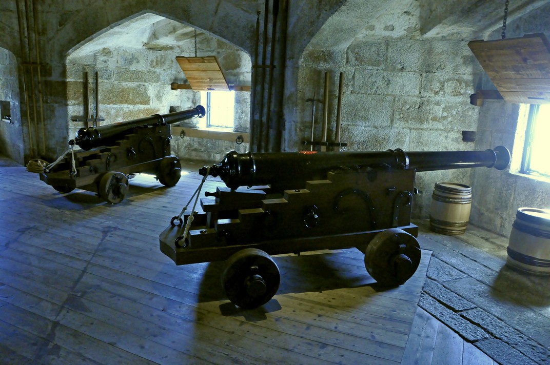
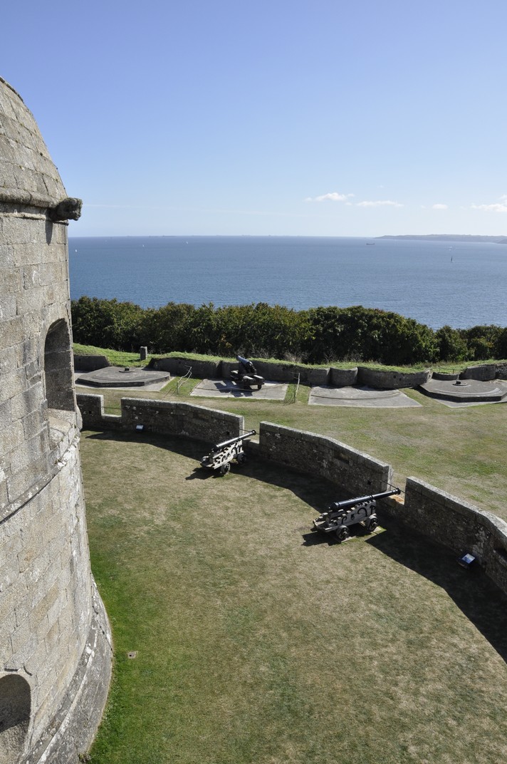
Pendennis has a fine collection of cannons inside and also on the battlements, as well as the Second World War guns at Half Moon Battery.

Looking southwest to the mouth of the Helford River

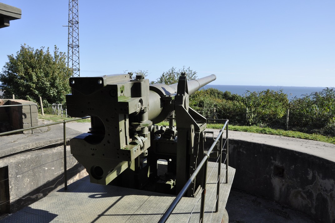
At Half Moon Battery

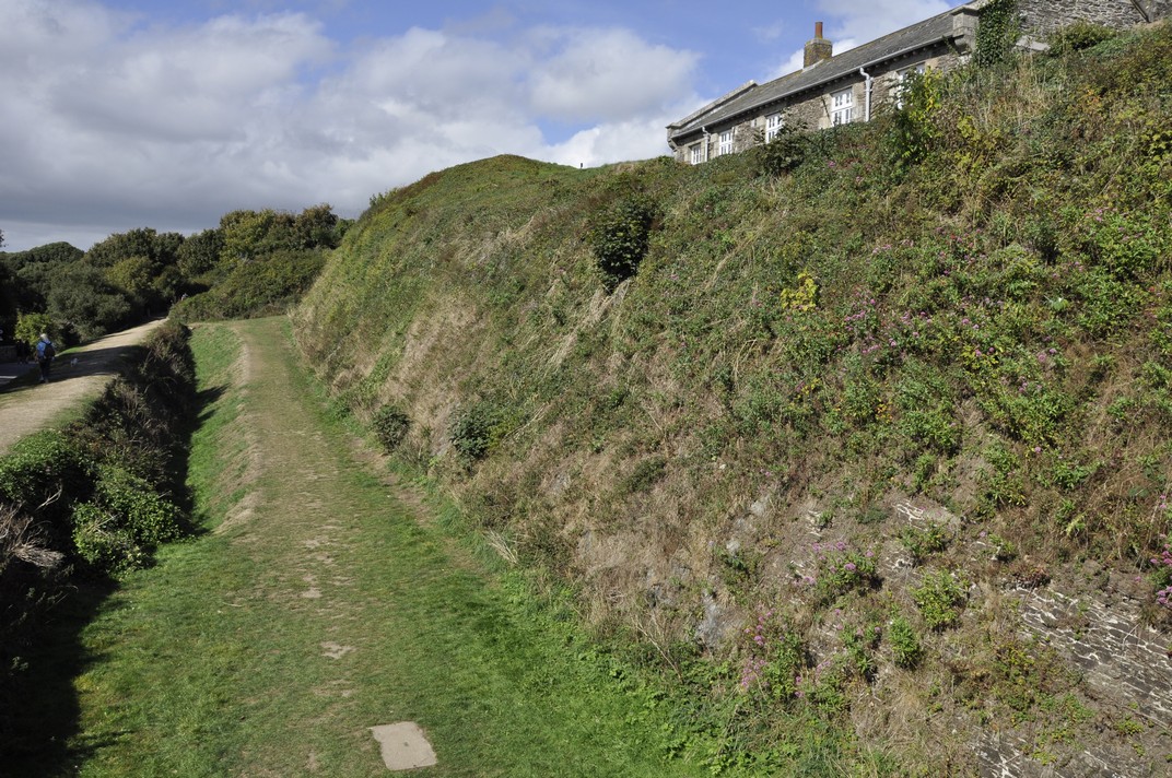
The castle is not just the round tower. There are extensive 18th century barracks and parade grounds enclosed within major earthworks, ramparts constructed during the reign of Elizabeth I.

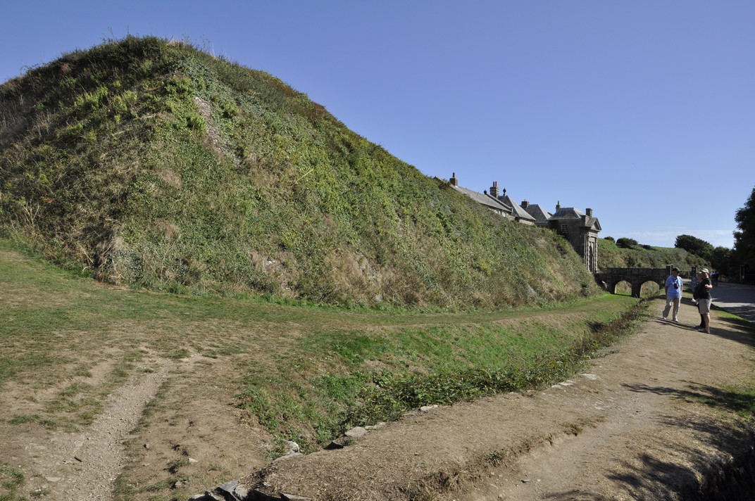
Earthworks leading to the main entrance (and below as well)

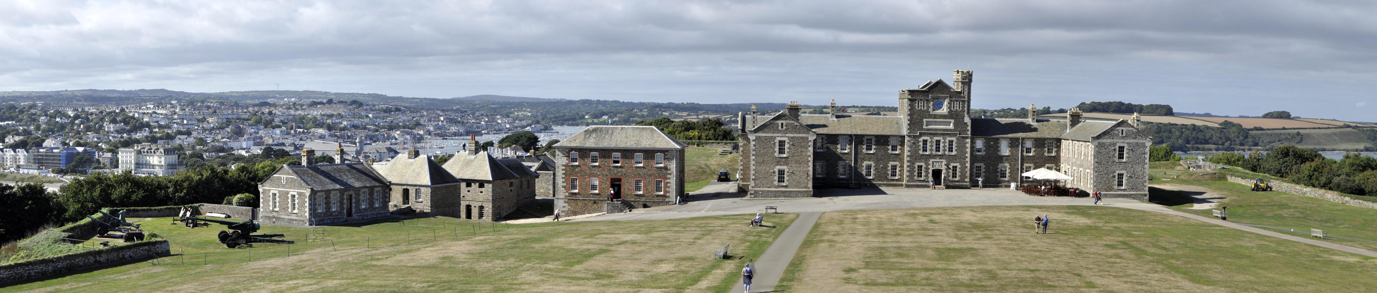
The barracks (on the right) and guardhouse on the left, from the roof of the Tudor round tower.

Check out more photos here.


These are the other four stories in this Cornwall series:

Kernow a’gas dynergh – Welcome to Cornwall (1): The journey south . . . and back

Kernow a’gas dynergh – Welcome to Cornwall (2): Coast to coast

Kernow a’gas dynergh – Welcome to Cornwall (4): An impressive horticultural legacy

Kernow a’gas dynergh – Welcome to Cornwall (5): Magnificent mansions

Kernow a’gas dynergh – Welcome to Cornwall (2): Coast to coast

On reflection, I’m not completely sure our choice of holiday accommodation was appropriate.

It was located in the far south of Cornwall, just north of Helston, excellent for visiting the coast around the Lizard and Land’s End Peninsulas, but not so handy for any of the other sites we wanted to visit in the north of the county. So on two or three days we had 100 mile plus round trips. Maybe we should have looked harder to find a cottage in the center of the county.

Nevertheless, it was very comfortable, and in terms of facilities and cost, it was just what we were looking for. And we were very happy with our week’s stay there.

Having traveled more than 250 miles south on the Saturday to reach Cornwall, we decided to spend the first two days, Sunday and Monday, exploring the coast in the far south. In any case, perusal of the weather forecast indicated that these two days would be favored by warm and sunny weather, ideal for enjoying the coast.

First port of call was Lizard Point (owned by the National Trust), the most southerly point on the British mainland. We always hear about John o’ Groats to Land’s End. But I think it should be Dunnet Head, the most northerly point on the mainland, in Caithness (which we visited in 2015) to Lizard Point.

Lizard Point, from the east

Having found the National Trust car park, we set off east along the cliff path towards Lion’s Den, a hole in the cliff created when a cave collapsed in the mid-1800s, overlooking Housel Bay.

The cave fall lies immediately in front, overlooking Housel Bay

Just as we approached Lion’s Den, I saw two black birds take to the air from a field to the side of the path, and fly down into Lion’s Den. Could those be choughs, I asked myself.

I hadn’t seen the distinctive reddish-orange curved bill and legs, but their call and size were different from either crows or jackdaws that were common in the area, especially jackdaws.

A local naturalist confirmed they were choughs, a resident pair that had nested at the Lizard in 2018. A few minutes later and he showed us a photo he’d just managed to take (with a super telephoto lens) of one of the birds deep down inside Lion’s Den.

So we returned to the spot, a few meters away where he took the photo, and waited. We could hear them calling. Our patience was rewarded, for after a couple of minutes, one of the birds hopped on to a ledge in full sunlight, and I had a brilliant view of this remarkable rare bird. Once common in Cornwall, choughs only returned to the Lizard in 2001, although more can be seen on the north coast of the county. We’d seen the Lizard’s only choughs! Needless to say, we were chuffed! Magic!

Returning to Lizard Point, we heard this eerie crying, wailing almost, coming from Enoch Rock just offshore. Talk about mermaids enticing unsuspecting sailors to their doom, shipwrecked on hidden rocks (no wonder the lighthouse was built there). A group of Atlantic grey seals was basking in the midday sunshine and calling to one another.

We enjoyed a coffee, overlooking Polpeor Cove, at Britain’s most southerly cafe, before heading west to follow the path towards Old Lizard Head through Pistil Meadow. On the way there were great views of the old lifeboat station, home to the RNLI’s biggest rescue in March 1907.

The following day, we headed to the north coast of the Land’s End peninsula, and the National Trust’s Levant Mine and Beam Engine (that had just shut down when we arrived there).

Levant Mine is located on Cornwall’s ‘Tin Coast’ (part of the Cornish Mine World Heritage Site), west of Lower Boscaswell (map). The 1840s beam engine has been fully restored. Both copper and tin were mined here, and the mine stretched for 1.6 miles out sea, and more than 500 of feet below the seabed. The mine closed in 1930.

There’s a small museum providing a window into the past and who were the miners and their families (particularly young women) who worked at the mine, underground and at the surface sorting and cleaning the ore. The coast path passes by the mine, but we didn’t walk too far; it was just too blustery and at the end of the day (after several other visits) we were feeling a little tired. The landscape is dotted with the remains of engines houses and chimneys of mines and their shafts long abandoned.

Continuing round the coast near St Just, we ended the day at Cape Cornwall (map). We had already decided to give Land’s End a miss: too commercialized. Cape Cornwall in the late afternoon sun was more than an adequate substitute. What glorious views west over the Atlantic Ocean (next stop: North America); and south to Land’s End, jutting just that little further out into the Atlantic, with the Longships Lighthouse just over a mile offshore.

At the end of our week in Cornwall, we visited Marazion and its the sandy beach before crossing over to St Michael’s Mount.

St Michael’s Mount at Marazion at low tide

And to Tintagel on the north coast, where (after visiting the castle and the Old Post Office) we enjoyed a picnic lunch overlooking the Atlantic from the National Trust’s car park at Glebe Cliff beside the Church of St Materianna, that can be seen from Tintagel Castle.

There’s no doubt that Cornwall has a spectacular coastline; cliffs and beaches, waves for even the bravest surfer. The places we chose fitted in with our National Trust and English Heritage itinerary – and didn’t disappoint.


These are the other four stories in this Cornwall series:

Kernow a’gas dynergh – Welcome to Cornwall (1): The journey south . . . and back

Kernow a’gas dynergh – Welcome to Cornwall (3): Stepping back in time

Kernow a’gas dynergh – Welcome to Cornwall (4): An impressive horticultural legacy

Kernow a’gas dynergh – Welcome to Cornwall (5): Magnificent mansions

Kernow a’gas dynergh – Welcome to Cornwall (1): The journey south . . . and back

Steph and I began planning a short, one week break in Cornwall way back in the Spring. As followers of my blog will know by now, we are avid members of the National Trust and English Heritage, and throughout the year we try to make as many visits as the weather and other commitments permit. In Cornwall, we wanted to explore as many NT and EH properties as we could fit into the six days, and the two days of travel. Eighteen was our tally!

We chose a small studio cottage, suitable for a couple, just north of Helston on the south coast, a round trip of more than 500 miles (including the side trips to a couple of National Trust properties on the way there and back – see map). Dovecote Cottage was located at the end of a 2 mile drive down a narrow lane (with passing places), next to a former farmhouse. It was very peaceful, and comfortable.

Dovecote Cottage

Our home (in Bromsgrove, in northeast Worcestershire) is less than 5 miles from the M5 motorway, the main arterial to the southwest. The M5 and roads south into Cornwall like the A30 can be notoriously busy during the summer, and delays of many hours are not uncommon as lines of motorists (many towing caravans) snake their way to the coast and sunshine. On the way south we had a traffic-free journey, but on our return on the following Saturday we had to make one detour to avoid a jam at road works near Tiverton (on our way to Knightshayes), and we also hit a long queue of traffic attempting to navigate the bridge over the River Avon, backing up about 10 miles although constantly moving.

During the six days touring Cornwall we clocked up another 500 miles, for a total of 1086 miles for the whole holiday.


Heading south, and just 12 miles east of the M5 near Taunton, we visited Barrington Court, a Tudor manor house built between 1538 and the 1550s. It was the first house acquired by the National Trust (in 1907) and became the residence of Col. Abram Arthur Lyle (of the sugar refining company Tate & Lyle) who refurbished the property, installing his collection of historic woodwork, and converting the next door 17th century stable block, Strode House, into a residence. Check details of Barrington Court on the National Trust website.

The south face of Barrington Court (on the right) and Strode House on the left. The connecting corridor between the two can be clearly seen.

Barrington Court is unfurnished, but that also permits better appreciation perhaps of the fine woodwork. The long gallery on the top floor is particularly impressive.

In several of the bathrooms, reclaimed Delft tiles surround baths and wash basins.

During the 1920s refurbishment Lyle had asked Gertude Jekyll to design a series of formal gardens surrounding the house. In the eventuality not all were constructed, but what there are now are beautiful accompaniments to an elegant house.

A full album of photographs of Barrington Court can be opened here.


A week later, and we were headed north to take in Knightshayes, an imposing Gothic Revival mansion standing on a hillside overlooking Tiverton in Devon.

Knightshayes is a late Victorian house (built between 1869 and 1874), designed by William Burges, whose design excesses never made it completely into the interior of the house (although the National Trust has refurbished one room following his designs). The gardens were designed by Edward Kemp.

It was the home of the Heathcoat-Amory family for more than 100 years, and was handed over to the national Trust in 1972. The last occupants, Sir John Heathcoat-Amory and Lady Joyce carried out extensive work on the gardens in the 1950s and 1960s; both were awarded Gold Medals by the Royal Horticultural Society. Lady Joyce (née Wethered) was a world class golfer with many titles to her name.

The interiors at Knightshayes are impressive indeed.

The woodwork and decoration on the ceilings in many rooms is quite stunning.

A few photographs displayed here cannot do justice to Knightshayes, so please take a look at a more complete (and annotated) album of photographs here.

Knightshayes also has one of the largest walled gardens we have ever seen, and on the day of our visit there was a ‘heritage tomato event’.

One of the paintings on display at Knightshayes was recently featured in BBC Four’s Britain’s Lost Masterpieces. A small painting, not much more than 12 x 15 inches perhaps has been attributed to Rembrandt. Using the tool beloved of all art historians, a torch, we could highlight and see the detail in this beautiful small painting.

Rembrandt as a young man – self portrait attributed to the artist

But is it a Rembrandt? Perhaps.


These are the other four stories in this Cornwall series:

Kernow a’gas dynergh – Welcome to Cornwall (2): Coast to coast

Kernow a’gas dynergh – Welcome to Cornwall (3): Stepping back in time

Kernow a’gas dynergh – Welcome to Cornwall (4): An impressive horticultural legacy

Kernow a’gas dynergh – Welcome to Cornwall (5): Magnificent mansions

Relaxing in Minnesota

Following our epic drive in mid-June from Maine to Minnesota (after already having crossed Massachusetts, Vermont, and New Hampshire, and explored parts of western Maine for six days), Steph and I settled into a couple of weeks of relaxation with our elder daughter Hannah and family in St Paul, MN before heading back to the UK on 10 July.

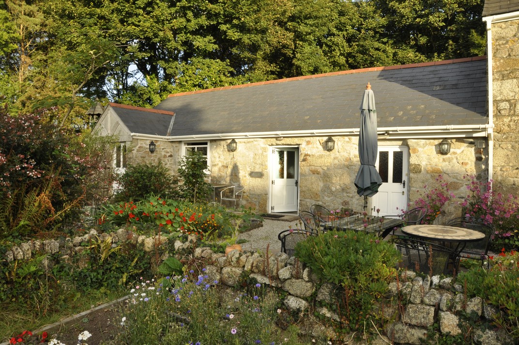
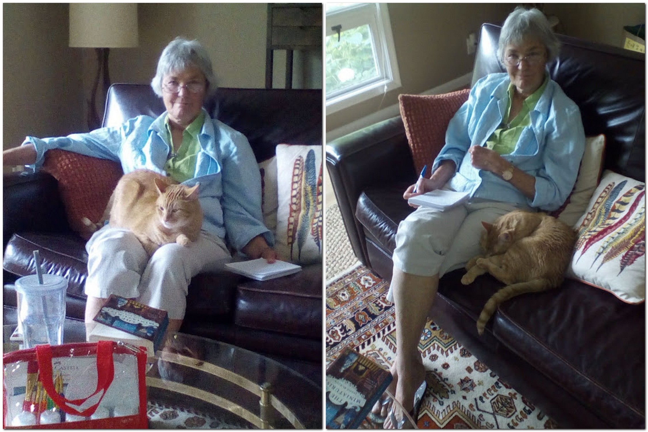
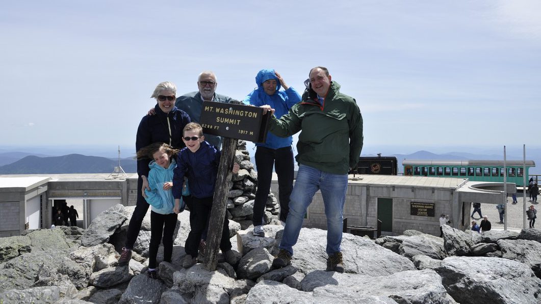
My son-in-law, Michael, is – like me – a beer aficionado, and keeps a well-stocked cellar of many different beers. It’s wonderful to see how the beer culture has blossomed in the USA, no longer just Budweiser or Coors. I had opportunity to enjoy a variety of beers. Those IPAs are so good, if not a little hoppy sometimes. However, my 2018 favorite was a Czech-style pilsener, Dakota Soul from the Summit Brewing Company based in St Paul.

Relaxing in St Paul was also an opportunity catch up with some of my blogging, while Steph spent time in Hannah’s garden making sure everything was coping with the very hot weather. Notwithstanding the regular watering, we did experience a couple of quite spectacular downpours the like of which I haven’t seen for some time.

And our lively grandchildren, Callum (eight just two days ago) and Zoë (6) kept us on our toes. For one of the two weeks we stayed in St Paul, I was their summer camp chauffeur, dropping them off at the bus just after 8 am each day, and picking them up late in the afternoon. We were also ‘babysitters’ over six days and five nights. That’s the first time we’ve taken on this role; it was the first time that Hannah and Michael left the children with grandparents for more than just an overnight stay, while they celebrated their 40th birthdays with a visit to California’s Napa Valley.

Outcome? I think Callum and Zoë survived us – no permanent harm done!

There’s quite a lot of ambiguity associated with looking after someone else’s children – and they know it! Even though it was made clear to both that ‘Grandad and Grandma were in charge’, you’re often faced with situations asking yourself how Mum and Dad would react. Obviously we haven’t looked after small children for more than three decades since Hannah and Philippa were small. Although we had TV in the 1980s, there were no video games, or subscription channels like Netflix offering up a continuous menu of cartoons.

Both Hannah and Philippa had quite a large circle of friends within easy distance of home, some just a few doors away. So whenever the weather was fine – or even if it was not – one or the other would be round a friend’s house, or the friends at ours. It’s a sign of the times but ‘play dates’ have to be arranged for both Hannah’s and Philippa’s children. This is not only a reflection of busy lives for Mums and Dads, but also that no friends live next door.

We had fun with Callum and Zoë, although they might not perhaps reflect well on the occasions when I had to ‘lay down the law’. We went bike riding (they did the riding while we followed on foot), and explored the fascinating glacial potholes at the Interstate State Park 53 miles northeast from St Paul beside the St Croix River at Taylors Fall.

Afterwards we spent time at a splendid children’s playground at Stillwater. We ate out one night, went out for breakfast on the Sunday, and had a BBQ. Here are some more photos of that outing.

Grandma Mary (Michael’s mother) took the children to the Minnesota Zoo one day so Steph and I could enjoy a day at the Minnesota Landscape Arboretum (here are the 2018 photos), somewhere we have visited a couple of times in the past.

Beautiful echinaceas, a typical species of the prairies

And any visit to St Paul would not be complete without checking out the Marjorie McNeely Conservatory at Como Park (map).

We’ve been going there since 2006 when it was the venue for Hannah and Michael’s wedding. The floral displays change with the seasons, and we always enjoy seeing what the gardeners have prepared for their many visitors. This summer’s display was much more subdued compared to other years.

May 2006

December 2007

July 2016

June 2017

June 2018

I would certainly recommend a visit to Como Park  if you’re ever in St Paul. There is also a small zoo and fun fair, very popular with the children.

The Mississippi River is just 50 m from Hannah’s front door, but at least 50 m below. There are some lovely walks and parks along the river, Hidden Falls Regional Park, about a mile from Hannah’s, being one of them. But the river was high this year, with flooding closing several of the walks nearby. The St Croix River at Stillwater was the highest we have ever experienced.

Beside the Mississippi at Hidden Falls Regional Park.

The St Croix River at Stillwater. That’s Wisconsin on the far (east) bank.

Finally, this commentary about relaxing in Minnesota would not be complete without mention of Hobbes, a lovely ginger rescue cat who has his moments, going from sweet and docile to full on attack mode at the drop of a feather. But over our time at Hannah and Michael’s he did begin to relax with us and, more often than not, this is how he spent much of his time.

Blown away by Mt Washington . . .

Or, rather, blown away on top of Mt Washington.

Compared to the mountain ranges in the west of the USA, Mt Washington (at 6288 ft – 1917 m) and nearby peaks in the Presidential Range of New Hampshire’s White Mountains are mere foothills. From their base, however, they still look pretty impressive. Mt Washington is the highest mountain in the northeastern USA and experiences some pretty spectacular weather.

Steph and I got our first glimpse of Mt Washington as we crossed New Hampshire recently on the first part of our road trip that also took us through Massachusetts and Vermont on our way to Maine to spend a week there with our elder daughter Hannah and her family, who had flown in from Minnesota.

I’d chosen a route from Burlington, VT taking us north towards the Canadian border, then dipping down to the southeast through the White Mountains close to Bretton Woods, site of the momentous 1944 conference that aimed at regulat[ing] the international monetary and financial order after the conclusion of World War II. The conference led to the founding of the World Bank (or International Bank for Reconstruction and Development) and the International Monetary Fund.

Having worked for many years for two of the centers funded through the Consultative Group on International Agricultural Research (CGIAR), that had been established in 1971 under the auspices of the World Bank, I was interested to see the location where it had all started, so to speak.

And as we skirted a bend on US302, heading southeast, there was the famous hotel off to the left, nestling under the Presidential Range. In the middle was Mt Washington (just left of center in the photo below), clearly higher than surrounding peaks, and on which we could just make out some infrastructure we later discovered to be part of an observation station.

During our week in Maine we made several excursions, and one of those was the seven mile drive on the Mt Washington Auto Road that takes you to just below the summit, from 1500 ft the park entrance west off NH16 (White Mountain Road).

Amazingly, construction of the Auto Road (originally the Carriage Road) commenced in 1854, and was completed in 1861, opening to the public on 8 August that year. Over the past 157 years, more than 4 million tourists have reached the summit.

The fastest ascent on foot (in 2004) took just a few seconds short of 57 minutes (and only seven minutes quicker by bike). By car, Mt Washington has been climbed in just 6 minutes 9 seconds (in 2014). We took rather longer, at least 30 minutes, as we stopped whenever possible to enjoy the spectacular views, as well as negotiating some of the curves rather gingerly.

The road is paved most of the way, although near the summit there is a short gravel section.

The summit can also be reached by a cog railway! The train ascends on the western flank of the mountain; the station is situated a short distance beyond the hotel at Bretton Woods.

The cog railway, heading ‘vertically’ up the mountain can be seen just right of center.

Apparently the summit is hidden in clouds for about 60% of the year. Not so on the day of our visit. We couldn’t have asked for better weather, and the views, in all directions, were just awesome.

That’s Bretton Woods in the distance . . .

It wasn’t too windy either, blowing between 40-60 mph. Even so, we struggled to keep upright at the summit signpost.

60 mph is nothing on Mt Washington. On 12 April 1934 the world record wind speed (observed by humans) was recorded at 231 mph! Can you imagine that? Besides a small cafeteria, there is a small but interesting exhibition at the summit, with some of the instruments used and observations recorded on that momentous day 84 years ago.

I guess we spent a little under two hours at the summit, enjoying the panoramas in all directions. We couldn’t have hoped for a better day. Once we were down, there was time to relax in the sun, enjoy a picnic, and even take forty winks. We were even given a certificate for ascending the mountain.

So, if you are ever in the vicinity, and the weather looks half decent, I’d recommend the drive up the Auto Road. We weren’t disappointed.

~~~~~~~~~~~~~~~~~~~~~~~~~~~~~~~~~~~~~

Here is a link to a bigger album of photos taken at Mt Washington.

Sometimes, history just passes me by . . . particularly in Ohio

William Tecumseh Sherman. Red-haired. Union Major-General in the American Civil War. Outstanding military strategist. Commander of the Army of the Tennessee. Mastermind of the March to the Sea (that culminated in the capture of Savannah, GA) and the Carolinas Campaign, both of which contributed significantly to the end of the Civil War in 1865.

Born in 1820, Sherman was a native of Lancaster, Ohio (map). I wish I’d known that just a few weeks ago.

As Steph and I crossed Ohio on our road trip from Massachusetts to Minnesota, we passed through Lancaster on the route I’d planned from Canton, OH to Bloomington, IN. I do recall saying to Steph how prosperous it looked compared to others.

I only learned of the Sherman connection from a biography that I’m reading right now¹, and which I picked up at my favorite bookstore in St Paul, Half Price Books on Ford Parkway in the Highland Park area. This year I added three more to my American Civil War collection.

I could have made the Sherman connection in Lancaster had I looked in my rear-view mirror at the right moment, but I was too intent on following the sat nav instructions.  There, on a west-facing wall on Main Street (we were heading west) is a full height mural of Sherman. I didn’t see it, more’s the pity. I would have stopped to explore further.

During the first part of our 2017 USA road trip, from Atlanta, GA (which Sherman ransacked in 1864) to Savannah, our route more or less mirrored Sherman’s March to the Sea. In the historic neighborhoods of Savannah his name appears on several historical markers, as you might expect.

And there were other surprises. Just 18 miles northeast of Lancaster is the small community of Somerset, OH. It has a lovely town square, in the middle of which is an impressive statue of a mounted soldier, Philip Sheridan, a Major-General of Cavalry during the Civil War, who was eventually promoted to four star rank. Sheridan grew up in Somerset. After the Civil War he served on the Great Plains during the Indian Wars. He was also instrumental in developing Yellowstone as a national park.

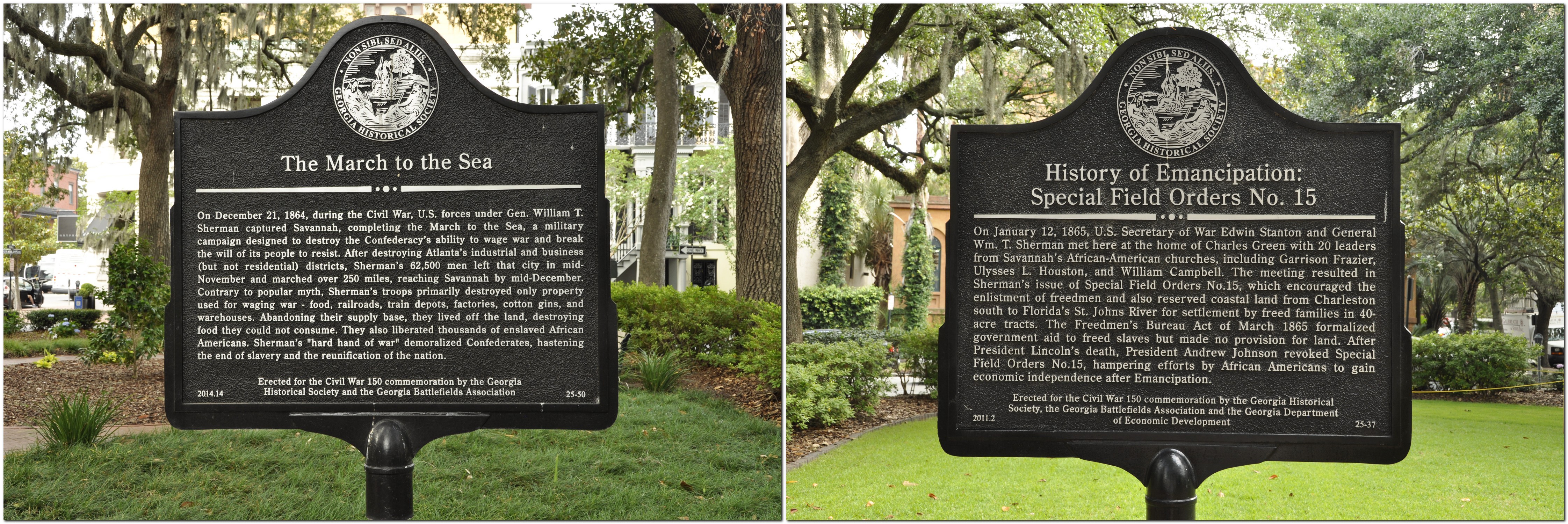
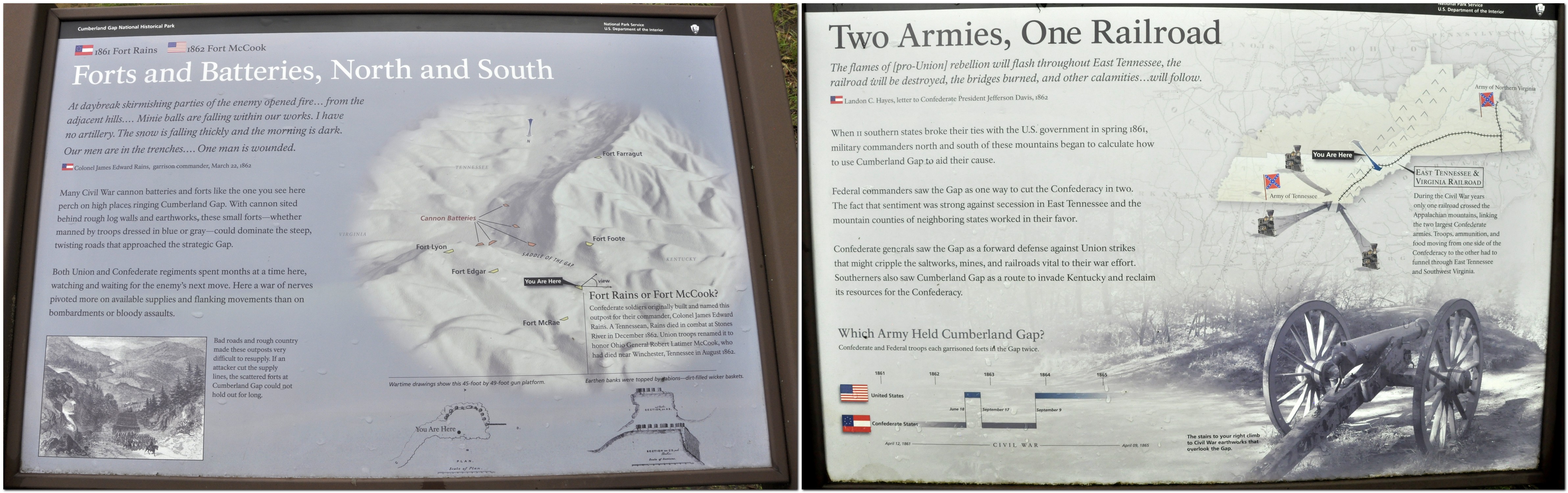
Despite its incredibly bloody outcomes and destructive consequences, the American Civil War, 1861-65 holds a certain fascination. To a large extent, it was the first war to be extensively documented photographically, many of the images coming from the lens of Mathew Brady.

But in terms of the war’s theater of operations, much of the fighting took place east of the Mississippi River, across the southern states, and into the maritime states as far north as Pennsylvania.

Imagine the topography, especially in the Appalachians, across which huge armies marched and fought each other. Imagine the effort needed to transport tens of thousands of men and their equipment and supplies over almost impenetrable terrain, along river valleys, crossing ridges, swamps, and huge rivers, while constantly being harassed by and engaging with the enemy.

We saw much of this landscape along our 2017 road trip. At Cumberland Gap there were even reminders how the opposing armies had fought to gain the upper hand and strategic overlook that was afforded on the hills surrounding this important pass through the mountains.

In that Sherman biography, I also learned that his superior, Major-General (then Brigadier General) Ulysses S Grant² (yet another Buckeye from Point Pleasant [map], just across the Ohio River from where we traveled this year) had his headquarters at Cairo (map) at the southern tip of Illinois in 1861, just a couple of miles north of Fort Defiance on the promontory at the confluence of the Mississippi and Ohio Rivers. Fort Defiance was on our route west in 2017.

Southwest from Canton, OH we passed by close to Dover (map), birthplace of one the Civil War’s most notorious Confederate raiders or bushwhackers, William Clarke Quantrill³. His theater of operations was the Kansas-Missouri border, an area that was already experiencing conflict between abolitionists and those who wanted to keep slavery in Missouri as early as 1858. Quantrill’s Raiders were the perpetrators of one of the Civil War’s most outrageous atrocity, the Lawrence (Kansas) massacre. Sherman’s brother-in-law, Thomas Ewing, Jr was a key Union general opposing Quantrill.

So while I may have missed out on some interesting historical aspects during this year’s road trip, that was not the case in 2011 when we toured extensively in Arizona and New Mexico. Earlier that year I had read an interesting biography of mountain man and Indian fighter Kit Carson whose campaigns against the Navajo are well documented. I planned parts of the trip around locations where he had been active. He is buried in Taos, NM, and after spending time at the Canyon de Chelly (site of a massacre of Navajos) in northeast Arizona, we headed for Taos.

Spider Rock in the Canyon de Chelly.

History is undoubtedly one of my principal hobbies, and occupies much of my reading. On retirement eight years ago I almost enrolled for a history degree with the Open University, but eventually decided to keep it just as a hobby. I read very little fiction, and the catalyst for my 2017 challenge – to read all of the novels by Charles Dickens – was a book (also bought at Half Price Books) about the terrible plight of children (early in the 19th century) in factories and cotton mills in the north of England.

Here in the UK, Steph and I are very active members of the National Trust and English Heritage. Whenever we get the opportunity, we head off to one of their many properties (stately homes, castles, archaeological sites, gardens) open to the public. And we learn a little more each time about the history of this country and the people who shaped events over the centuries, for better or worse.

~~~~~~~~~~~~~~~~~~~~~~~~~~~~~~~~~~~~~~~~~~~~~

¹ Robert L O’Connell (2014). Fierce Patriot – The Tangled Lives of William Tecumseh Sherman. Random House. ISBN 978-0-8129-8212-1.

² I picked up this biography of Grant which I have yet to start: HW Brands (2012). Ulysses Grant in War and Peace. Anchor Books. ISBN 978-0-307-47515-2.

³ I started this book about Quantrill’s Raiders first. Jesse and Frank James were members of Quantrill’s guerilla band. Edward E Leslie (1998). The Devil Knows How to Ride – the True Story of William Clarke Quantrill and His Confederate Raiders. Da Capo Press. ISBN 0-306-80865-X.


Driving on the ‘wrong’ side

Since 2011, my wife and I have made several long-distance road trips across the USA. And although I’d driven some short distances around Seattle and the Twin Cities of Minnesota, I’d never done any serious driving until then. So, it’s not uncommon for someone to ask whether I find driving in the USA difficult.

Answer: not really. Most don’t know that I spent over 27 years driving on the ‘wrong’ side, i.e. the right, while living in Peru, Costa Rica, and the Philippines.

So driving on the ‘wrong’ side is as normal for me as driving in the UK, on the ‘right’ side on the left. It’s just a case of learning the dos and don’ts, and the manners of the road.

Driving in the USA is (mostly) a pleasure (and straightforward), since away from the cities and main highways, the roads are generally quite quiet. However, some of the Interstates can be quite daunting, especially when two or more come together or diverge like large bowls of spaghetti, often with three or more lanes. Choosing which lane to occupy and when is a challenge. My sat nav during our latest trip was a godsend.

Finding your way around however is not too difficult. The road numbering system is quite clear, but the same road can have more than one name if two highways merge for a section. The Interstates (like the motorways in the UK or autobahns in Germany for example) connect centers of population across the country and are a legacy of President Dwight D Eisenhower, from the 1950s. Then there are the US highways, state roads, and county roads. Each has its own road symbol.

US highways are often divided highways, or dual carriageways as we say in the UK. The one big difference between the Interstates and US highways however, are junctions on the latter (often controlled by traffic lights) where you might have to stop. Most state and county roads are single lane carriageways in each direction.

Compared to the UK, speed limits are generally lower in the US. The norm for Interstates is 70 mph (I’ve seen 75) with a minimum of 40 mph. The maximum speed on US highways is 60 mph (occasionally 65), but most often 55 mph widely applied across the country. In towns the limit is often as low as 25 mph, and special lower restrictions (15 mph) often apply near schools when in session.

Speed limits and driving restrictions around school and school buses are rigorously enforced. When a school bus stops, lights flashing and the Stop sign extended from the rear offside of the bus, you’d better stop or else, whether you’re behind or approaching the bus. I must admit that I didn’t initially realize that the rule applied to oncoming traffic. I remember when we were traveling on US101 in northern California that I passed a stationary bus. Luckily there was no speed cop waiting to ‘ambush’ me.

Roads are more congested with trucks (lorries) in the UK than in the USA, but trucks are behemoths in the USA in comparison, and consistently travel at much higher speeds, often well over 70 mph on the Interstates.

This was one ‘extra’ size load that we saw in Wisconsin.

The idea of overtaking on both sides is something I still cannot reconcile. But it’s common in the USA on roads with more than two lanes. Just maneuvering between lanes can be a nightmare, having to check fast-approaching vehicles on both sides. Also, drivers tend to join a highway high speed; they ‘take no prisoners’, and just keep coming on despite other traffic approaching and occupying the lane they will join.

I often find US drivers reluctant to overtake on single carriageway roads. Admittedly there are oftentimes fewer opportunities to overtake. As I mentioned, we like to take the byways when making one of our road trips, mostly on single carriageway highways, and I try to keep more or less to the speed limit. So I find it aggravating when a ‘local’ starts to tailgate me, ‘encouraging’ me to go faster. But when the opportunity to overtake presents itself, they just remain tucked in behind. Clearly they want to go faster but are not prepared to exceed the speed limit to overtake.

Turning right on a red light 
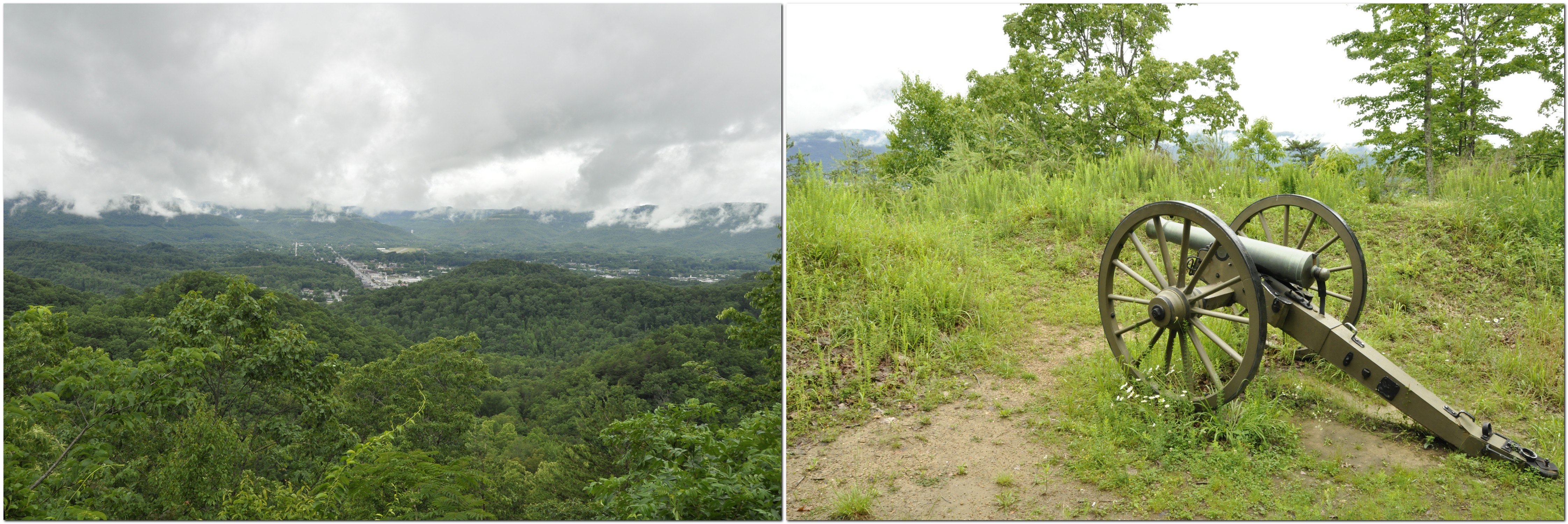
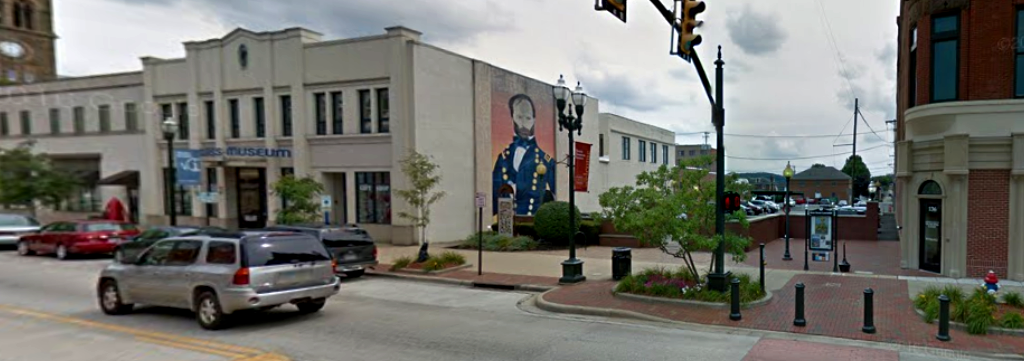
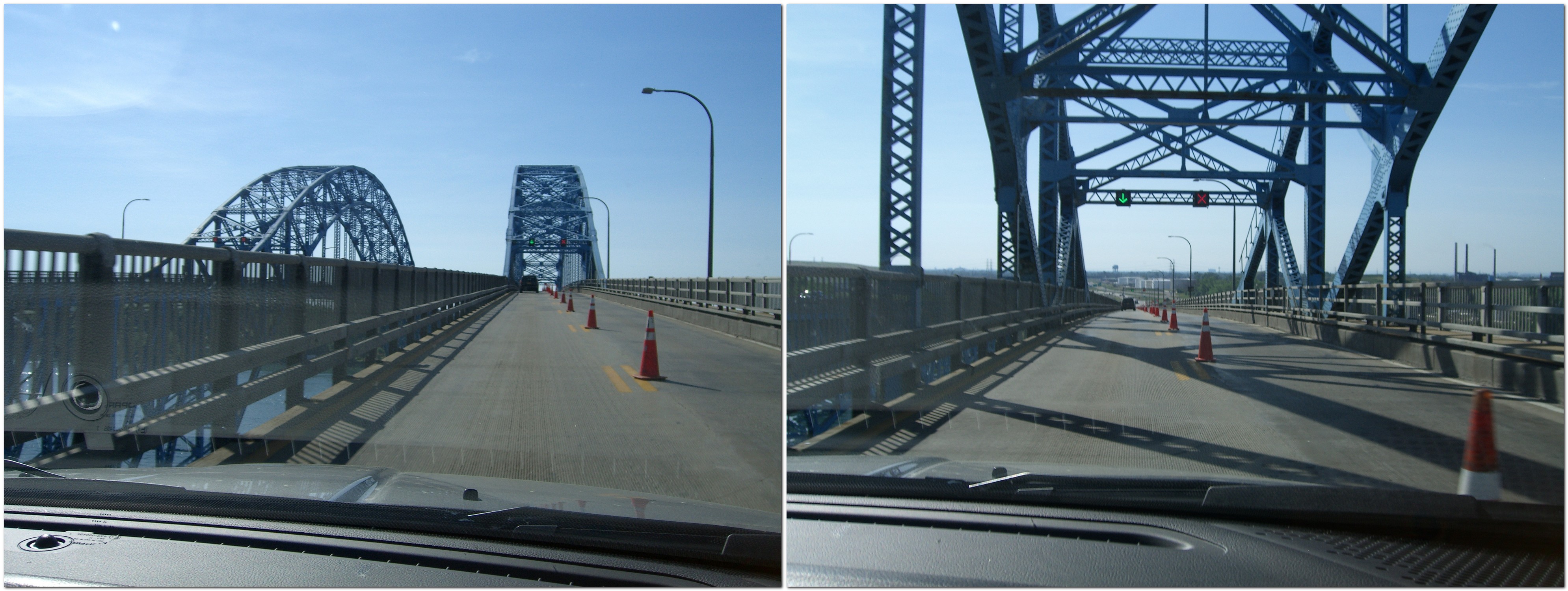
takes some getting used to. I now understand that unless it specifically states not to turn, it’s OK to make that turn. Not something we’re used to in the UK. Red means red! And also, having to be aware that if you turn right on a red light, there may be pedestrians crossing as they will have right of way.

‘Right lane must turn right’ (or left) is a common sign on most roads. In fact, it’s useful to have a sort of slip road for departing traffic even on single carriageway highways. But it can be confusing at a junction, when you suddenly find yourself in the right lane and are forced to turn even though you want to go straight ahead. Fortunately my sat nav helped in this respect, and having become accustomed to this situation, I try to position myself in the left lane at a junction to avoid an unwanted manoeuvre.

Roundabouts are common in the UK. Near my home in Bromsgrove there are five within the space of 2 miles. Not so in the USA. Instead there of full stop, all way junctions, governed by a particular road etiquette: the first vehicle arriving at the junction gets to manoeuvre first, but only after coming to a full stop.

When I look over what I have just written, it seems to me that my driving concerns in the USA are not really very important at all. We’ve now covered somewhere in the region of 15,000 miles I guess in our trips. Plenty of time to get accustomed to driving on the wrong side.

However, thinking about the dos and don’ts of driving made me ponder on some other aspects of visiting the USA. And, as it happens, I came across this article, by Sophie-Claire Hoeller (a trilingual journalist who grew up in Germany) in Business Insider: 51 things Americans are doing wrong.

For ease of reading, I also copied her list of ‘things’ into a file.

So, how do these resonate with me? Several on the list are bugbears of mine: (4) Portion sizes; (6) Tipping; (7) Taxes; (12) So. Many. Questions; (16) Checking ID; and (49) Serving a salad first.

I never cease to be amazed by the amount of food that is served in restaurants. Portions are huge compared to the UK. No wonder there’s an obesity problem. I’d rather portions were smaller and bills lower.

Ten per cent is the norm in the UK when tipping – if you think the service warranted a tip. Not so in the USA, where tops as high as 25% are the norm AND expected. I agree with journalist Sophie-Claire. Why should I pay someone else’s wages? In one restaurant recently, where I’d left a 15% tip on the table for our server, I was faced with adding a tip of 25% (no lesser amount) – or none – when using my debit card at the checkout.

Why don’t retailers in the US just include the sales tax in the price listed? How many times have I been caught out at the till, having to add on the tax. Thank goodness for plastic money, and although I used my debit card more this last trip for everyday expenses than I had in previous years, I still ended up with a purse-full of small change. The grandchildren’s piggy banks benefited!

While we were traveling from Massachusetts to Minnesota, we would buy sandwiches, often from Subway, so we could stop anywhere on the route to have our lunch. Then the questions start: wheat or wholemeal, Italian, this meat or that, cheese, mayo, pickles . . . etc., etc. Phew!

I’m almost 70, yet, when buying a couple of cases of beer at Target in St Paul recently, I was asked for my ID! Fortunately the lady at the checkout was from Scandinavia (and had lived in the UK for several years) so recognized my UK photo driving licence. She told me that normally it would have to be a US or Canadian driving licence or passport. Good grief, 70 years old and having to present a passport just to buy a beer! And then there was $2.36 sales tax to add to the offer of $25 for two cases that had attracted my attention.

Salads should be served on the side. Period. I got a strange look from one server when I asked her to bring my salad with the entree. That’s how I like to eat my salad, not as a meal in itself before any other course.

Yes, the UK and USA, two countries separated by a common language (and with Trump in charge, many other things unfortunately), according to George Bernard Shaw. But we enjoy our visits there. It’s a vast – and sometimes quirky – country. Lots more to explore!


Planning a USA road trip

Steph and I like to explore.

Since 2011, we have made five major road trips across the USA, and two of shorter duration.

That first year, we headed for Arizona and New Mexico, taking in the Grand Canyon, Canyon de Chelly and other interesting sites in those dry climates.

We decided to stay closer to home (home being where our daughter Hannah and her family live in St Paul MN) in 2012, just visiting the Boundary Waters Wilderness Region and the Gun Flint Trail of northern Minnesota .

2013 saw us on the Pacific coast of Oregon, and a trip as far south as Sacramento in California, taking in Oregon’s Crater Lake and the Californian redwoods on the way.

We headed west from St Paul across the prairies in 2014, the first of our really long trips, taking in the Badlands and Mt Rushmore in South Dakota, Devil’s Tower in Wyoming, the Bighorn Battlefield in Montana, and Yellowstone National Park.

We toured Scotland in May-June 2015 so decided not to make any road trip in the USA, instead choosing to take Amtrak to Chicago for three days.

I broke my leg in January 2016, so any long road trip was out of the question. However, we made a short trip north of the Twin Cities to find the source of the Mississippi River.

The Appalachians called us in 2017, so we flew into Atlanta and drove back to Minnesota through Georgia, South Carolina, North Carolina, Tennessee, Virginia, West Virginia,Kentucky, Illinois, Missouri, and Iowa.

We were equally ambitious this year, taking in New England (Massachusetts, Vermont, New Hampshire, and Maine) before heading west to Niagara Falls in New York, and then south and west through Pennsylvania, Ohio, Kentucky and Indiana, before heading north into Michigan, crossing Lake Michigan on the car ferry, and driving across Wisconsin to end up, once again, in the Twin Cities.

Until this year, I had planned our trips using various maps. For the Arizona/New Mexico and Oregon/California trips in 2011 and 2013, and for trips around Minnesota, I purchased a DeLorme Atlas & Gazetteer for each state. These are very detailed and comprehensive, and show even the most minor of roads. Since we like to take highways and byways (US roads, state highways, and even county roads) as much as possible and avoid the busy Interstates, these DeLorme publications allowed me to draw up quite detailed itineraries.

But they are heavy! And once we planned to drive from Georgia to Minnesota in 2017, carrying around a DeLorme Atlas for each state was not an option.

Instead, I purchased Rand McNally road maps for each state, and plotted a route using Google maps, then transferring it to the map itself, as shown in the image below. I also verified the route using Google Street View, especially to check out the various road junctions.

Steph was the navigator – which had the unfortunate consequence that she had to have her head in a map day in and day out. To assist with navigation I also drew up detailed route instructions on separate cards for each day. One of these is shown in the upper image above. These provided information on the road numbers (roads in the US can carry more than one number as roads combine for short or long distances), junctions, and any other special feature or attraction that we had decided to visit.

However, at Christmas 2017, I received a Garmin DriveSmart™ 51 LMT‑S GPS Navigator with a 5″ display, which came with UK and Ireland maps installed (that are regularly updated).

One of the features I really like is the accompanying BaseCamp software installed on my laptop that allows me to plan routes, with any degree of detail, and transfer them to the sat nav. Once I’d got the hang of its idiosyncrasies, I began plotting routes from home in the UK, finding the best options, and at the same time learning the various features of the sat nav itself.

In BaseCamp I found the easiest way to plot a route was to choose the starting and destination waypoints, and let the software ‘find’ the optimum route. In this example below, I plotted a route from Niagara Falls NY to Canton OH, which was the third day of our recent trip after leaving Maine.

As you can see if you open a larger image, the route calculated would have taken us on the interstate close to the shore of Lake Erie. But I wanted to cut across country and travel through the Allegheny Forest of Pennsylvania.

BaseCamp allows you to shape any route by adding ‘via points’, as many as needed to develop an unambiguous route when it is recalculated by the sat nav itself once transferred.

Then, once all the via points have been added, your final route, below, is transferred to the sat nav.

My Garmin proved invaluable during this trip, especially when we did travel on the Interstates, and these merged with one another, giving me advice when lane changes were necessary, changes to speed limits, and always anticipating any junctions half a mile ahead.

We only had a couple of glitches. Once, after we’d arrived at our hotel, I discovered the reason why the sat nav had asked me to make a U-turn on one street earlier in the day. I’d programmed in the same via point twice. Another time, in deepest Ohio, one of the roads I’d chosen was closed some miles ahead, so we had to follow a set detour. The sat nav didn’t like that, urging me to make a U-turn, or turn at the next junction. Having completed the detour, our original route appeared on the screen, and on we continued. On another occasion, crossing Kentucky along the Ohio River, we had to make another detour, and suddenly the icon for the vehicle was moving across a blank screen – until we reached another road that it recognized. I think we had been diverted on to a new road that wasn’t programmed into the USA maps I’d bought before the trip.

With the installed UK and Ireland maps, I receive updates all the time. The USA (and Canada and Mexico) maps are a one-time purchase, not particularly cheap, but well worth it. It’s just a pity that Garmin does not offer regular updates for these purchased add-on maps as well.

The sat nav is great, but we also found it useful to have a map to refer to see the bigger picture. We were able to find road maps for some states in hotel receptions or at state information centers.

And one of the biggest advantages of using a sat nav? Steph no longer has to navigate hour after hour, and can enjoy looking at the changing landscapes. I wouldn’t say I was particularly stressed on any of my earlier road trips. But with the sat nav I did find that my anticipation level was much lower, and I could also enjoy seeing the countryside we were passing through, knowing that I would be navigated safely to our destinations, especially through built-up areas.

Massachusetts to Minnesota (4): heading west through NY, PA, OH, KY and IN, then on to MN

Leaving Niagara Falls via the Niagara Scenic Parkway on the Sunday morning, we headed south, skirting Buffalo and the eastern shore of Lake Erie towards Pennsylvania, and the Allegheny National Forest. Our destination was Canton in Ohio, just south of Akron, a journey of 313 miles.

Along the Niagara Scenic Byway, there are two impressive bridges across the Niagara River on I-190.

There was little traffic around Buffalo, fortunately, even though it was a fine morning for Father’s Day. Soon enough we were outside the city limits and heading south into Pennsylvania.

Pennsylvania was a ‘new’ state for us (as were OH and IN), and I particularly wanted to travel through the Allegheny National Forest.

We travel on the interstates as little as possible, taking US highways and county roads in preference. You get to see a lot more of rural America that way. But roads are none too wide with few places to stop. And certainly no easy stops for photography. So on these two days we have little to show, photographic-wise, for our long days on the road.

The next morning we had an early start as we decided to cover the whole route that I’d planned, some 447 miles south through Ohio, crossing the Ohio River into Kentucky, before crossing the river again further west into Indiana to reach our next destination, Bloomington.

The drive through OH took us through some delightful towns and villages, and productive agricultural landscapes. Although we saw road signs to be aware of Amish buggies on the road, we only saw a couple.

Somerset is a small town about 110 miles south of Canton. In the middle of its impressive town square (which had a very English feel to it) there was a statue to a famous son of Somerset, Union General Phil Sheridan.

We also passed by Dover OH, home to infamous Confederate guerilla leader William Clarke Quantrill (I just bought a biography to read), and also Bainbridge, home to the first dental school in the USA, opened in 1825.

Eventually we reached the Ohio River at Aberdeen OH. The Ohio is a very impressive river and as I commented in a post after last year’s road trip, its flow is greater than the Mississippi. No wonder that rivers like the Ohio were used to open up the interior of the country.

This is the bridge that carries US68 into Kentucky. We crossed a little further west on the William H Harsha Bridge, carrying US62.

Aberdeen is also the terminus of Zane’s Trace, the first continuous road through Ohio, from 1798.

Crossing into northern Kentucky, we were less than 50 miles north of where we had driven through the state in 2017. Then it was over the Ohio again, and into southeast Indiana. Our good friend and former IRRI colleague Bill Hardy (a native born Hoosier) told us that we should see the southern part of the state, since the northern half was flat and rather uninteresting, maize upon mile of maize. He was right. The drive into Bloomington was delightful in the early evening sunshine, with Highway 46 weaving through the trees, up and down dale.

After a restful night in Bloomington (yet another Comfort Inn!) we set off the next day for the penultimate sector of our trip that would take us to Ludington on Lake Michigan in the state of that name. This was another long drive, over 400 miles, north to Gary IN, and then wending our way north along the eastern shore of the lake.

Just over the state line into Michigan we stopped to have a quick picnic lunch at a rest area (and Michigan information center) on I-94. We were very impressed with the amount of tourist literature and maps available at the information center; Michigan certainly knows how to sell itself.

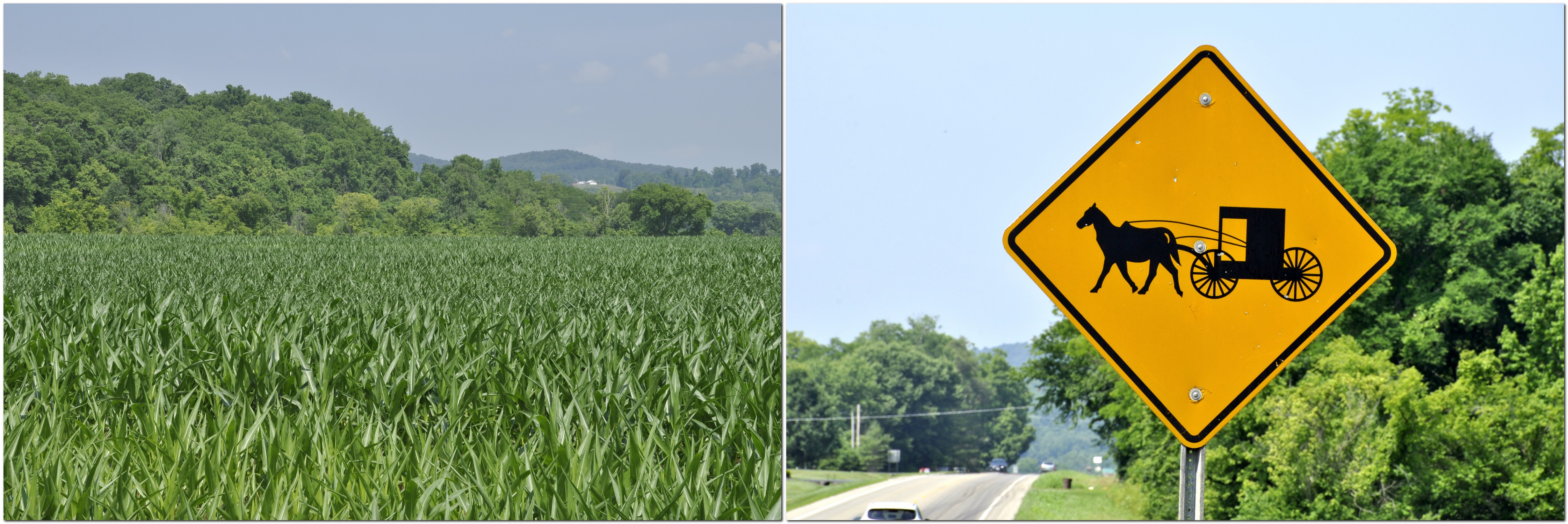
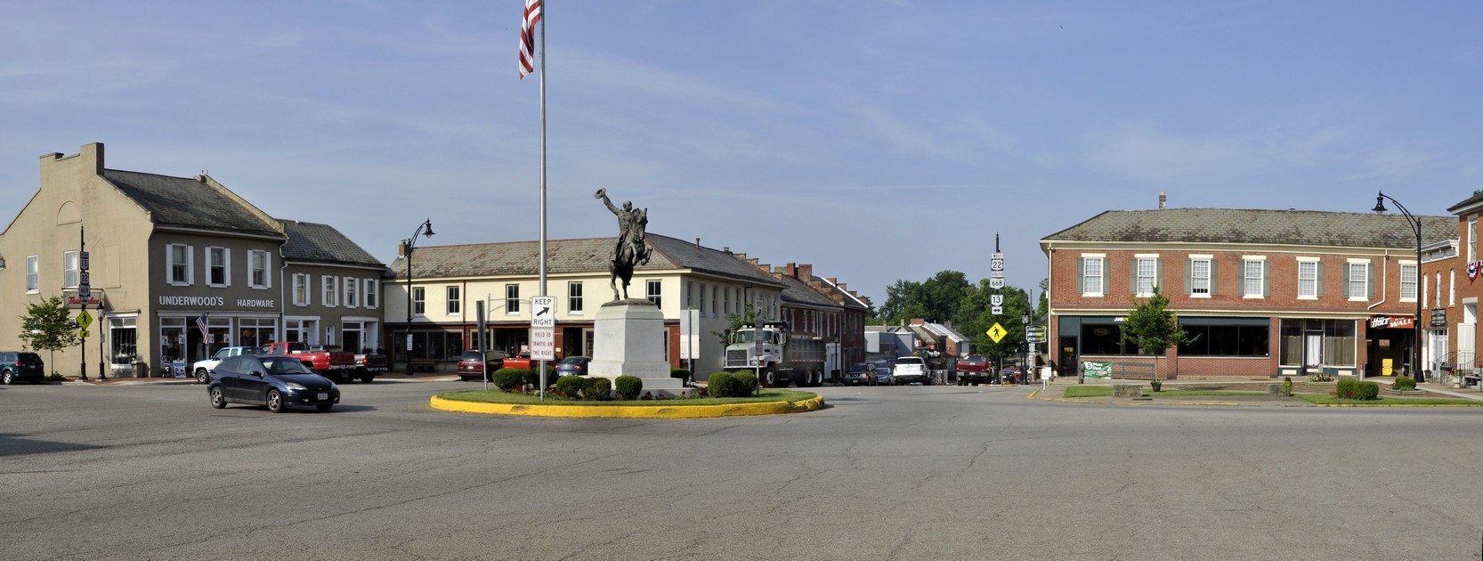
Just north of the state line we took a short detour to Warren Dunes State Park. Lake Michigan is like a vast internal sea, and along its shores, certainly the eastern shore, there are huge sand dunes, now covered with mature woodland. The sand is extremely soft, and hard to walk across. Just like being at the seaside, and although the day was overcast, enough brave souls were enjoying beach to the maximum.

This is Tower Hill Dune that rises to more than 230 feet above Lake Michigan.

Then it was back on the road again, heading for our last night stop of the trip, at Ludington, before taking the ferry across Lake Michigan the next morning to Manitowoc on the Wisconsin shore.

The ferry, SS Badger, across Lake Michigan is operated by LMC – Lake Michigan Carferry. Badger is the last coal-fired ferry operating in the world.

It is 393 feet long, and has a beam of almost 60 feet. It was built in 1953 in Sturgeon Bay, WI. Its sister ship, Spartan, has been laid up in Ludington for many years. Originally the ferries carried rail cars.

The 60 mile crossing of the lake takes four hours, but you gain 1 hour moving from Eastern Standard Time to Central Time. As it was a Wednesday in mid-June, before the height of the tourist season, the boat was far from busy. The slow, easy-paced crossing was just my opportunity to catch up on some sleep, in readiness for the final push into the Twin Cities from Manitowoc across Wisconsin, some 321 miles.

We were at the dockside a little after 07:30, and they started to board the vehicles shortly afterwards for an on-time departure from Ludington at 09:00. Vehicles are driven on board by company staff. So before we sailed we had a good look around the vessel.

Soon enough we were headed out of Ludington harbor.

And before we knew it, Manitowoc was coming into view, and everyone was getting ready to disembark.

I had planned a route across Wisconsin that took us from Manitowoc through Stevens Point on US10. We took I-43 north for a couple of miles or so, then came off to take US10, only to see a sign stating that the road was closed some miles ahead. With that, I changed the settings on my satnav to take the quickest route to St Paul, rejoining I-43 around Green Bay, and west on Highway 29, until we joined I-94 west of Chippewa Falls for the final 75 miles into the Twin Cities. Highway 29 was a nightmare. Although a dual carriageway (a divided highway) it just went on and on, unrelentingly, in a straight line across Wisconsin. However, we did arrive to Hannah and Michael’s almost an hour earlier than anticipated.

Thus ended our 2018 road trip across twelve states: MA, VT, NH, ME, NY, PA, OH, KY, IN, MI, WI, and MN.

In nine days we covered 2741 miles, plus another 477 miles in Maine itself during the six days we stayed at the cabin. We used 133 gallons of gasoline, at a cost of $384 ($2.89/gallon, less than half of what we would have to pay in the UK for the same amount of fuel), at an average consumption of 24.19 mpg.

I’m already planning for 2019; Georgia to Texas through the southern states seems a distinct possibility.

~~~~~~~~~~~~~~~~~~~~~~~~

See the other posts in this series:

Massachusetts to Minnesota (1): the first three days in MA, VT and NH

Massachusetts to Minnesota (2): a week in Maine

Massachusetts to Minnesota (3): onwards to Niagara Falls

Massachusetts to Minnesota (3): onwards to Niagara Falls

Leaving Waterford, ME for Niagara Falls early on the morning of 15 June, we allowed two days for this sector of our trip, 366 miles on the first day, and 289 on the second.

We headed west to the Kancamagus Highway through the southern part of the White Mountains of New Hampshire, and a slow climb to reach the the pass at 2855 feet. The cloud level was quite low, and at some scenic overlooks there was sometimes very little to see. But luck was on our side, and we did have some spectacular views in all directions, particularly at Pemigewasset Overlook northwards.

There were many road signs warning of the presence of moose along the highway throughout much of the trip in New England. But we saw neither hide nor hair, not even an antler. Roadkill raccoons were two a penny. This road sign (courtesy of Trip Advisor) warns drivers at the start of the Kancamagus Highway.

Once across the mountains, we turned south for about 30 miles on I-93, to join US4 to cross Vermont, a section we had more or less traveled the week before.

About 10 miles south on I-93 we saw a sign for road works ahead, and we could see the traffic slowing. But then I could also see vehicles moving beyond the ‘obstruction’, one at a time. Funny situation, I thought to myself. Anyway, to cut a long story short, agents (maybe 20 or more, plus dogs) of the US Customs & Border Protection were checking all vehicles for occupants. And, having British passports, we were asked to pull over while I retrieved our passports from a suitcase in the back. Once checked, we were waved on our way. By coincidence, I had read earlier that day a story about these ‘border checks’ miles and miles from any international border (with Canada in our case, or in the south with Mexico).

Once in Vermont we passed through a pretty town named Woodstock. No, not that one – that’s in NY. There was an interesting covered bridge, constructed in 1969 to replace an iron one that had been put across the river in 1877. Apparently this wooden construction was cheaper than other options.

Our destination for this night was Herkimer, NY, about 10 miles east of Utica. Crossing from Vermont into New York, we headed north into the Adirondacks Regions and west around Indian Lake, following for the first part, the valley of the Hudson River.

The following day, we headed west from Herkimer towards Ithaca (home of Cornell University). We passed through many delightful villages, among them Sauquoit where Steph spotted a memorial plaque. I regret not stopping, since it commemorated Asa Gray, born 18 November 1810 (same birthday as me), who is considered the preeminent American botanist of the 19th century.

We enjoyed the rolling landscape, dotted with small farms, the chapels in the villages.

St Paul’s Church, Paris Hill, established in 1797. This is the oldest parish in Western New York, from 1838.

At Ithaca, we stopped to have a picnic lunch beside Lake Cayuga, one of the Finger Lakes that characterize this part of upstate New York.

This is also wine country, and the views across Lake Seneca heading north towards Geneva were stunning. Wineries everywhere!

As we had a prior engagement in Niagara Falls NY that evening, I changed our route, joining I-90 west just north of Geneva rather than cutting across country (a much longer route) as I originally intended.

We arrived in Niagara Falls just before 5 pm, and after checking into our hotel close to the city center and the Falls, we decided to stretch our legs by taking the short walk to the American Falls. The light was just right, and although it was quite busy, I’m sure later in the season this site could be heaving with tourists.

So what was this prior engagement? We had arranged to meet my cousin Patsy and her husband David, who had driven down from Ottawa the day before and were staying on the Canadian side. They had never been to Niagara Falls before either. I had met Patsy just once, in the summer of 1972 a few months before I headed off to Peru. Patsy (just 12 then) and her elder sister Karen had come over to the UK with their mother Bridie, one of my Mum’s younger sisters, to meet the Healy side of the family.

We had arranged to meet for dinner at a small Italian restaurant, La Cuccina Di Mamma on Rainbow Boulevard. What a lovely time we had: great company, good food, and heaps of reminiscing! Steph and David were most indulgent towards Patsy and me.

The next day we were up early to take advantage of the good weather, and to view the Horseshoe Falls from Terrapin Point on Goat Island, and the American Falls in the other direction from Luna Island.

The best views of the Falls (mist permitting) are from the Canadian side, but we decided not to cross over. Instead, Patsy sent me these two photos of the American and Horseshoe Falls from their side of the border.

And this short (<3 minute video) illustrates the awesome power of the falls, with a flow of 675,000 gallons/second over the Horseshoe Falls, and 75,000 gallons/second over the American Falls (both relating to summer daytime flow).

Around 10 am, we’d explored all that we wanted, and so set off on the next stage of our journey, 760 miles over two days southwest through New York into Pennsylvania, Ohio, a brief stretch through Kentucky along the Ohio River, and on to Bloomington, Indiana.

~~~~~~~~~~~~~~~~~~~~~~~~

See the other posts in this series:

Massachusetts to Minnesota (1): the first three days in MA, VT and NH

Massachusetts to Minnesota (2): a week in Maine

Massachusetts to Minnesota (4): heading west through NY, PA, OH, KY and IN, then on to MN

Massachusetts to Minnesota (2): a week in Maine

It has been great to meet up with our elder daughter, Hannah, and her family (Michael, Callum, and Zoë) for a week in a cabin at Waterford in Maine, taking a short break in our road trip. They flew in from St Paul (Minnesota) three days after we landed in the USA, and on the day that we drove over from Burlington in Vermont, crossing the White Mountains in New Hampshire.

And what fun we have all had together. It’s wonderful to see them again. It has been a year since we were last over on this side of the Atlantic.

On Saturday we decided not to stray far from the cabin, just the short distance to Hawk Mountain to take in the breathtaking panoramas south and west of Waterford.

Sunday was Michael’s 40th birthday so we celebrated by a visit to Attitash Mountain Resort, about 50 miles west of the cabin along US302. This map shows all the excursions we made during the six days we spent in Maine.

I’d been expecting huge crowds, and long queues for the rides. But no! Although school was out in some areas, the resort was quiet, and we could take as many rides up and down the mountain as we liked, and no waiting.

There were two rides that we enjoyed: the Alpine Coaster, and the Alpine slide. Never having experienced either, Steph decided to ride with Hannah on her Coaster ride; I took Zoë. Callum rode with Michael.

I’d seen videos on YouTube of alpine coasters around the USA. The one at Attitash is advertised as the longest. This is what it looks like.

Michael managed to capture me on his cellphone during one of my descents.

The Coaster was quite a bone shaker. More fun for us ‘oldies’ was the mile long and awesome descent on the Alpine Slide. It’s a bit like the Olympic luge. And we could all take our own carts, even Callum and Zoë.

Here’s what it looks like from a rider’s perspective, from a video I found on YouTube.

To begin the ride, it was necessary to take the chairlift up the mountain, about a 10 minute ride, with incredible views over the surrounding mountains.

And when it all got too much, it was nice just to sit back, relax in the sun, and watch the others having the time of their lives.

Being Michael’s special day, we stopped off for dinner at a recommended restaurant, where he enjoyed lobster, and the rest of us something not quite so exotic. The end to a great day.

After all the excitement of the previous day, we decided to take it easy on the Monday. So Hannah and Michael took the children around McWain Pond in a canoe.

Meanwhile, this was a great opportunity for me to enjoy yet another cold beer in the sunshine, and Steph to knock off another couple of chapters of the book she’d brought with her.

On the Tuesday we set off for Mt Washington, at 6228 feet the highest mountain in the northeast of the USA, and where the highest wind speed was recorded in the 1930s.

We passed by Mt Washington near Bretton Woods on the west side of the mountain while traveling across New Hampshire the week before.

It’s a seven mile drive up to the summit, and we enjoyed a 360° panorama at the top. We were lucky. For more than 60% of days, the summit is completely fogged in. While it was windy (40-60 mph), it was just about manageable.

There’s also a cog railway that climbs to the top, bringing even more tourists who don’t relish the drive. While we were at the summit several trains arrived, and I was fortunate to capture this shot of three at the summit.

After the slow descent, and heating of the brakes, we found a nice spot to enjoy a picnic, let the car cool down, and a rest for ourselves.

On the way back to Waterford, we finally came across one of New England’s famous covered bridges – at Jackson, NH! They really are fascinating, and from what I could tell from various plaques and information online, they are really cherished.

Wednesday and Thursday were our big excursion to the coast, to Camden on Penobscot Bay for an all-day sail around the bay on Sailing Vessel Owl with Capt Aaron (Lincoln) at the helm, a direct descendant of folks who came to the USA in the 1680s.

Michael used to sail these waters with his mother and stepfather when he was a boy, and was keen for Callum and Zoë to enjoy the same experience. We left the cabin by 06:30, and were ready for boarding the Owl around 09:30.

We set off east into the bay, arriving at the passage between North Haven and Vinalhaven (map) by lunchtime, in time for a short shore excursion on a small island. Until our return it had been warm and sunny, and mostly smooth. But as we set sail for the return to Camden, the wind got up, the waves increased and the temperature fell.

After a long day at sea, about 9 hours, we arrived back in the harbor, and enjoyed a welcome meal of freshly caught haddock. Since the drive from the cabin had taken about 2½ hours, we had already decided to spend the night in Camden, returning mid-morning the next day.

But before we left, we took a stroll around this pretty town and its harbor. In a small park overlooking the harbor there is a statue memorial to soldiers who fell in the American Civil War of the 1860s, referred to interestingly as The Great Rebellion.

There’s considerable wealth in Camden, given the large houses and boats moored in the harbor, owned by some of America’s most illustrious families.

Before heading back to the cabin at Waterford, Steph and I decided to take a look around Rockport, just a couple of miles south of Camden. On the point of a peninsula east of the town, the simple and beautiful Vesper Hill Chapel was built in 1962, and is dedicated to all young people who found God in their lives.

Then it was time to head west so that we would have enough time to pack, and prepare for the long trip even further westwards the next day.

Such was our week in Maine, enjoying time with Hannah and Michael, and the grandchildren. Callum and Zoë took everything in their stride, full of beans, and always ready for the next adventure. They keep us young!

~~~~~~~~~~~~~~~~~~~~~~~~

See the other posts in this series:

Massachusetts to Minnesota (1): the first three days in MA, VT and NH

Massachusetts to Minnesota (3): onwards to Niagara Falls

Massachusetts to Minnesota (4): heading west through NY, PA, OH, KY and IN, then on to MN

Massachusetts to Minnesota (1): the first three days in MA, VT and NH

It’s that time of the year, and here we are, on the road again in the USA. Another potentially daunting road trip that will take us from Boston, Massachusetts (MA) to St Paul, Minnesota (MN) via Vermont (VT), New Hampshire (NH), Maine (ME), New York (NY), Pennsylvania (PA), Ohio (OH), Kentucky (KY), Indiana (IN), Michigan (MI), and Wisconsin (WI), including a ferry crossing of Lake Michigan from MI to WI. This year I’m using my new Garmin DriveSmart 51 sat-nav, for which I purchased the USA-Canada maps. It saves Steph having to navigate, state by state, map by map, as in previous years, so she can enjoy looking at the passing scenery.

We are also spending a week near Waterford in western Maine, with our daughter Hannah and family (Michael, Callum, and Zoë) at a cabin on the shore of McWain Pond, one of the many small lakes that dot the landscape.

Anyway, it all started last Wednesday morning, very early, when a taxi picked us up from home at 04:00 to take us to Birmingham Airport (BHX) for our 06:00 KLM flight to Amsterdam Schipol (AMS), connecting with Delta 259 at 11:15 to Boston Logan International Airport (BOS).

Apart from a rather rude Delta ground agent at Schipol, our connection was uneventful, as was boarding (Sky Priority), and I was soon enjoying my first G&T on the 6 hour 55 minute flight, on a comfortable Airbus A330-300. When we landed in BOS there was a delay of more than 20 minutes while the ground crew figured out how to connect the air-bridge to the aircraft. But soon enough, we were checked through immigration on one of the newfangled automated passport control (APC) machines. I still had to pass through regular immigration (and facing another rude official who even queried me about any visits I’d made to the Middle East). Before long, luggage in hand, we were at the car rental center and picking up our SUV from Budget. The Mitsubishi we had been assigned had a flat battery, so Budget upgraded us to a full-size SUV, a Dodge Journey V6—rather larger than we needed, but extremely comfortable nevertheless, if a little heavy on fuel (about 25 mpg). But at USD3 a gallon, that’s not really an issue. It would be in the UK, however, where gasoline is more than twice the price!

We successfully navigated our way out of the airport and through the tunnels under Boston city center on I-90, after finally getting the sat-nav to behave itself. Our Wednesday night stop was in Hadley, in central MA, just over 100 miles west of Boston, and southwest by a handful of miles of Amherst.

Over the next two days we took in northwest MA, the Green Mountains of VT as far north as Burlington, and then over the White Mountains of NH, to arrive at our cabin destination in Waterford, ME.

Heading northwest from Hadley on Thursday, it was slow-going for the first 20 miles or so as we encountered school traffic and people heading to work. But soon we were in open country, on scenic byway 112 and often had the road to ourselves for long stretches (as we have enjoyed in past road trips). After about an hour we joined MA2, the Mohawk Trail, and followed that until North Adams where we turned north and crossed over into VT.

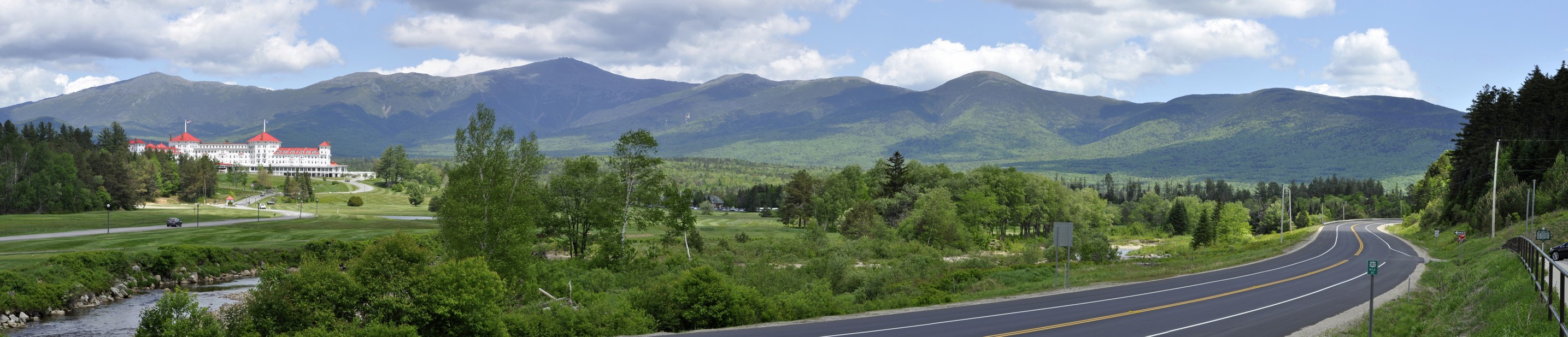
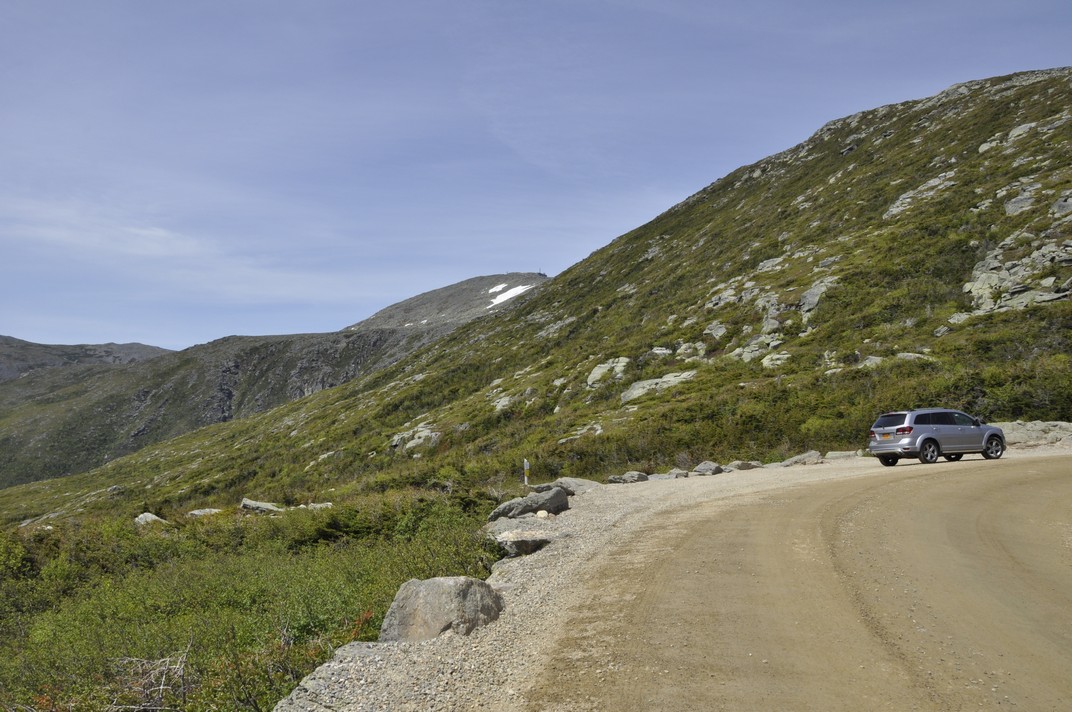
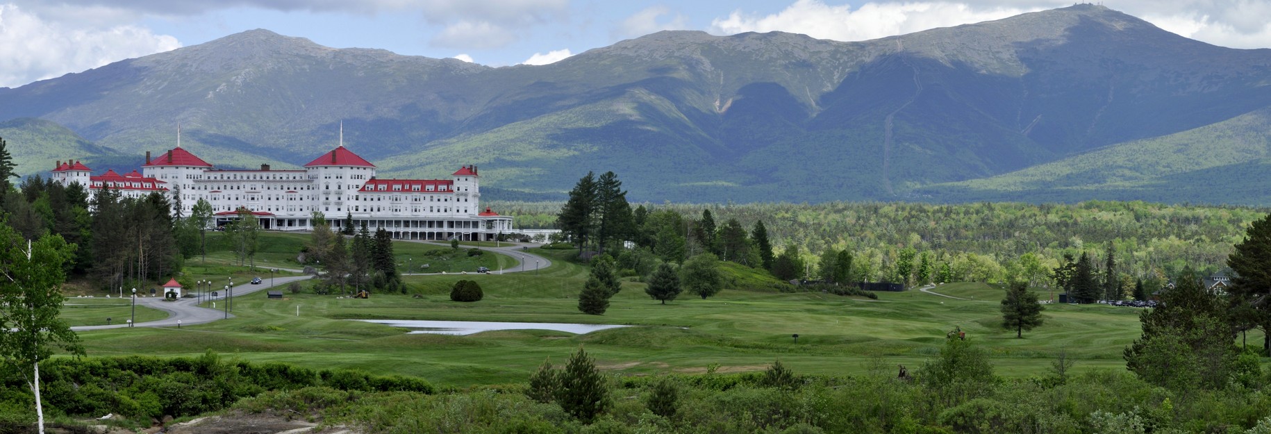
There was a glorious view south from Whitcomb Summit, and some miles further on, just short of North Adams, there is a spectacular view north into southern Vermont, reminding us of the views we saw when exploring the Appalachians in 2017.

Vermont is a beautiful state, with forested hills and mountains as far as the eye can see.

North of Wilmington, VT we stopped at a general store and deli to buy sandwiches and were intrigued with the Mini Cooper parked outside with an interesting registration plate BONKS. There was also a Golden Retriever with a Union Jack collar. We discovered that the proprietor was British, from Guildford in Surrey (near London)!

We spent Thursday night on the east side of Burlington, conveniently located for the next day’s travel northeast into New Hampshire and Maine, beginning around 08:00.

Most of the small communities we passed through have a general store or two, offering a whole range of produce, and many selling fresh sandwiches from a deli counter. We enjoyed a coffee in the sun at Westfield in the far north of the state, just south of the border with Canada.

Crossing into New Hampshire, we headed towards the White Mountains and were not disappointed with the fantastic view of the Presidential Range and the Mt Washington Hotel Resort at Bretton Woods. That’s Mt Washington just left of center, at 6288 ft the highest mountain in the northeast USA.

But Bretton Woods also has special significance for me. Why? Well, I worked for 27 years at two international agricultural centers, CIP and IRRI,  sponsored by the CGIAR (Consultative Group on International Agricultural Research). The CGIAR was founded in 1971 under the auspices of the World Bank. In July 1944, an international conference was held at the hotel to plan for a post-war world, following which the World Bank and the International Monetary Fund were created.

Stopping at Conway to pick up a supply of groceries, we finally reached the cabin around 17:00. A long enough day, followed by a couple of cold beers, an early night, but still far short of some of the travel we have yet to make.

Watch this space!

~~~~~~~~~~~~~~~~~~~~~~~~

See the other posts in this series:

Massachusetts to Minnesota (2): a week in Maine

Massachusetts to Minnesota (3): onwards to Niagara Falls

Massachusetts to Minnesota (4): heading west through NY, PA, OH, KY and IN, then on to MN

Almost 400 years of history in the vicinity . . .

Yesterday, Steph and I traveled some 40 miles southeast from our home in Bromsgrove in north Worcestershire, to revisit the National Trust’s Upton House and Gardens near the village of Edgehill in Warwickshire, that lies some seven miles northwest from Banbury (map).

We were last there in July 2012, combined with a trip to nearby Farnborough Hall. Take a look at a web album of photos that I posted afterwards.

Edgehill was the site of the first major battle of the First English Civil War, on Sunday 23 October 1642. Here the Royalist supporters of King Charles I clashed with Parliamentary forces under the Earl of Essex. The King had commanded the high ground and his troops marched down the Cotswolds escarpment to join battle with the enemy, arrayed below. The battle ended in stalemate.

The roar of cannons has long faded, as have the tramp of troops or galloping of horses, the clash of steel on steel, and the screams of wounded and dying men. Over the past four centuries the landscape must have changed immeasurably. Probably back in 1642 there were no fields, just open country, intermittently broken by woodland. And there certainly were no vivid blotches of bright yellow oilseed rape that are so typical of farming in the UK today.

A panorama over the site of the Battle of Edgehill, and north across Warwickshire.

We could see almost 40 miles west to the Malvern Hills, just visible (using binoculars) through the distant murk of an approaching weather front (that finally arrived with a vengeance overnight, and it has been raining heavily since). But what a magnificent view we had, almost perfect weather on May Day, even if a little chilly.

We had been intending to visit Upton just a few weeks ago, and enjoy the National Trust’s recommended ‘What a View’ Walk from Upton house, that takes in the Edgehill escarpment and the glorious view, a circular walk of just under 2½ miles that took around 1½ hours before arriving back at the car park to enjoy a welcome picnic.

We decided just to take a look at the gardens, rather than tour the house again. That would be a better option when the weather is inclement. Yesterday, after weeks of poor weather, it was just too nice to be inside.

The south front of the house overlooks the Main Lawn towards a ha-ha that disguises a steep drop to the Mirror Pool in the valley bottom.

The Main Lawn, looking south to the ha-ha, from where the garden drops steeply to the Mirror Pool. The open fields can be seen beyond the brick wall of the garden (see image immediately below).

The Mirror Pool from the ha-ha, with the Hazel Bank and Sunken Lawn on the right.

It’s remarkable how the landscape was adapted to create quite an intimate garden. We really must return again a little earlier in the year and enjoy the Spring bulbs. Most had already flowered, although there were some patches of Narcissi and beds of tulips adding a vibrancy in the early afternoon sunshine.

Looking west across the Mirror Pool to a magnificent yew behind the Kitchen Garden and the Dry Banks above.

A panorama of the Kitchen Garden and Dry Banks across the Mirror Pool, from the south. The ha-ha is at the top of the terraces, immediately below the Main Lawn.


‘High hills surround the valley, encircling it like a crown’ (Walter Daniel, 1167)

After the Normans conquered England in 1066, they quickly achieved hegemony over much of the country. By 1086 the ‘Great Survey’, the Domesday Book, had been completed for much of England and parts of Wales.

At the same time, different religious orders began to spread their influence and established communities around the country. In a peaceful and secluded valley beside the River Rye in the heart of the North York Moors near Helmsley, a Cistercian community founded Rievaulx Abbey in 1132, their first monastery in the north of England. A second magnificent Cistercian monastery, Fountains Abbey, lies about 27 miles west of Rievaulx.

Originally a cluster of wooden buildings, the abbey expanded over the next four centuries until Henry VIII’s Suppression of the Monasteries (after 1536). The abbey was abandoned and became the ruin we see today, still standing proudly in the landscape where it was founded. Not much can have changed in the intervening centuries. Rievaulx still exudes a profound sense of peace and tranquility.

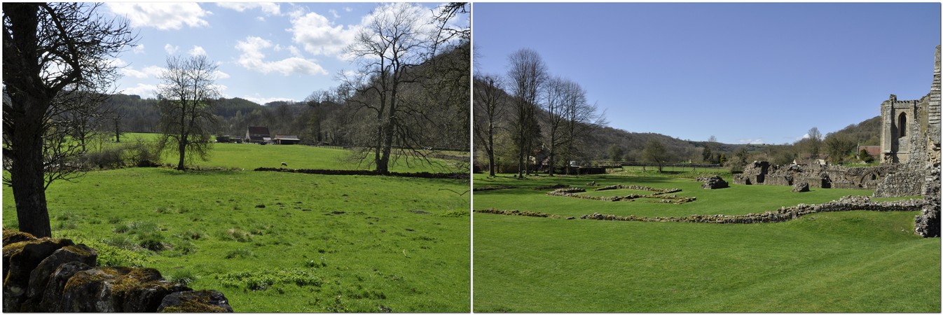
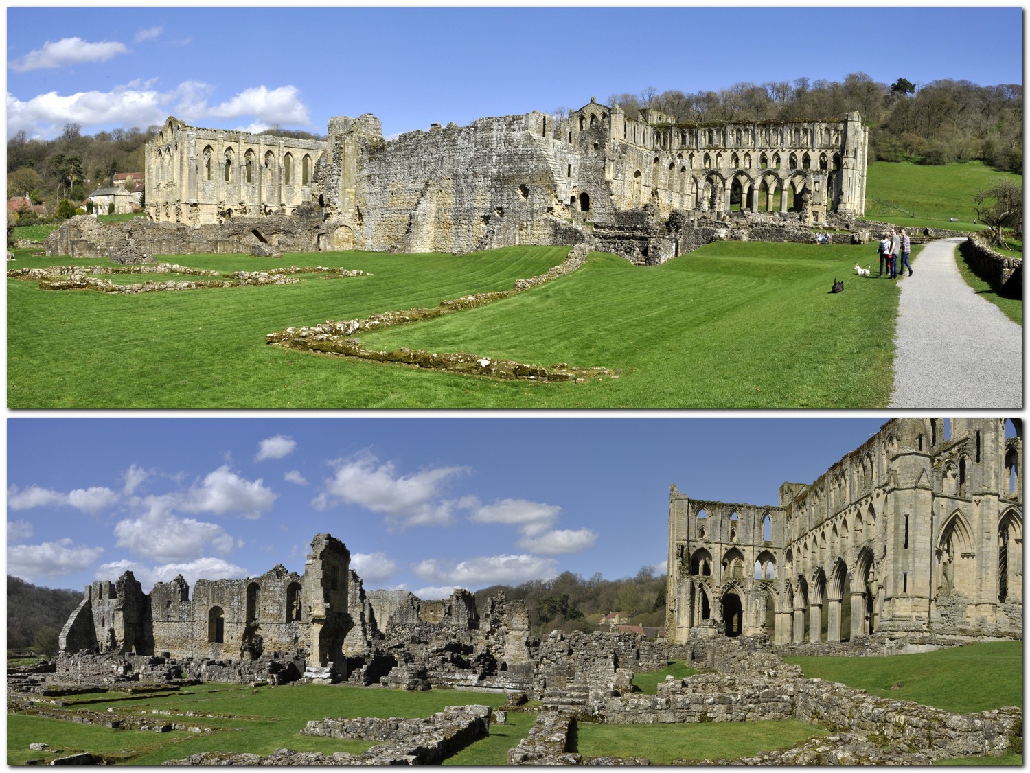
It’s not my intention here to provide a detailed history of Rievaulx Abbey. English Heritage owns and manages the site, and a detailed history of Rievaulx’s founding and growth can be found on its website.

I first visited Rievaulx in the summer of 1968 at the end of my first year at university, when I went on a youth hosteling holiday on the North York Moors. Fifty years ago! I can hardly believe it.

Then, in July 1988, when Hannah and Philippa were ten and six, we made a family visit while on holiday near the coast north of Scarborough. In 2013 we visited the National Trust’s Rievaulx Terrace that overlooks the abbey ruins (see below).

A week ago we took the opportunity of a visit to our younger daughter Philippa and her family in Newcastle upon Tyne—and the improving weather—to visit Rievaulx once again. It’s actually only a few miles off the usual A19 route we take when traveling to Newcastle these days.

It was a glorious sunny day. In fact, we enjoyed the first sensations of summer (the weather has since deteriorated, and it feels more like autumn as I write this blog post). The drive north from home (in Bromsgrove in northeast Worcestershire) took a little under four hours, including a 35 minute coffee and comfort break at the Woodall Services on the M1 south of Sheffield. On arrival at Rievaulx, we enjoyed a quick picnic lunch, then headed off to explore the ruined abbey and museum for about an hour and a half.

Rievaulx Abbey ground-plan (courtesy of English Heritage). Click on the image to open a PDF file of this plan, another one and a map of the valley where the abbey stands.

One’s first impression of Rievaulx are the ruins of the church, with tiers of pointed gothic windows on each side. There are some rounded and earlier Norman arches around the site. The eastern end of the church (enclosing the Sanctuary and Choir) was for use only by the monks. The western end, the nave (now completely demolished except for the bases of the main columns), was used by the lay brothers.

The Cloister and its Arcade must have been magnificent in the abbey’s heyday. Just one small fragment of the Arcade has survived, in the northwest corner of the Cloister. Immediately east of the Cloister are the remains of the Chapter House where monks came for their daily meetings. Several abbots are buried there, but the body of William, the first abbot was moved to its own shrine in the 13th century

This slideshow requires JavaScript.

To the south of the Cloister is large building housing the Refectory, and kitchen. The Day Room is located to the east of the Refectory, and this is where the monks worked on various activities, from mending clothes to copying manuscripts. South of the Day Room are the Tanning Vats where leather was prepared.

This slideshow requires JavaScript.

Further east is the Infirmary Cloister and a staircase to what became the Abbot’s House. Above the doorway is an original in situ figurative sculpture of The Annunciation.

This slideshow requires JavaScript.

There is a small museum displaying some interesting artifacts that have been uncovered on the site, as well as sections of sculptures that once adorned the various buildings of the abbey.

This slideshow requires JavaScript.

During its 400 years Rievaulx Abbey suffered several changes in fortune. There were raids from across the Scottish border, and the Black Death hit during the 14th century. The abbey was finally suppressed in December 1538, and the monks were cast out although they received a pension. The abbey was sold to Thomas Manners, Earl of Rutland although the most precious items were reserved for the crown. Thereafter the abbey buildings fell into ruin as we see today.

But there has long been a fascination with Rievaulx Abbey, and in the mid-eighteenth century, Thomas Duncombe II constructed Rievaulx Terrace high on the hillside above the abbey ruins where his guests could be entertained and walk. There are some spectacular views of the abbey from there, as we experienced in 2013.

This slideshow requires JavaScript.


Before the ‘Beast from the East’ strikes

Friday 23 February. A bright, sunny day, and not too much of a breeze. Although the day dawned with a covering of frost everywhere, it was not as cold as I feared. Still, there was a need to wrap up warm.

It looks like things will be rather different next week when the Beast from the East hits the UK. Beast from the East? That’s what the weather system from deepest Siberia has been labeled, and due to hit the UK early in the week, with Arctic sub-zero temperatures, and possibly significant snow fall. There’s a more or less stationary high pressure system over Scandinavia to the northeast of the UK, blocking ‘warmer’ weather systems driving in from the Atlantic, and at the same time drawing in all that cold Siberian air on a strengthening easterly air flow.

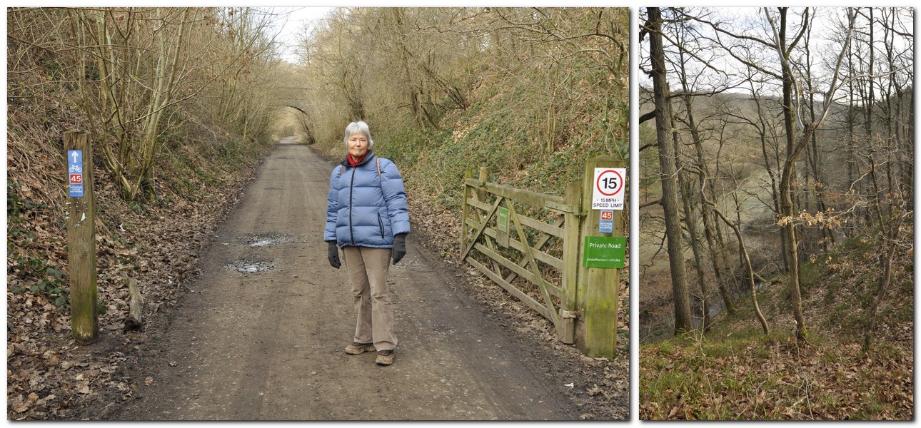
So, with much more inclement weather forecast, Steph and I decided that we’d better take advantage of yesterday’s decent weather and head out for a walk, and visit yet another National Trust property: Knowles Mill, a derelict 18th century flour mill alongside Dowles Brook in the heart of the Wyre Forest on the outskirts of Bewdley, about 18 miles west from Bromsgrove.

Knowles Mill along Dowles Brook in the Wyre Forest, with the mill cottage (privately-owned and undergoing renovation) behind.

There are no National Trust signs to Knowles Mill. It’s located within the Wyre Forest National Nature Reserve, and parking (with space for up to a dozen cars) can be found at the end of the very narrow Dry Mill Lane. We arrived around 10:20, and took one of the remaining spaces. Best to get there early although by the time we departed, just after noon, many of the cars had already left. As with all my blog posts, just click on the images to open a larger version.

We decided to follow the Dowles Brook Trail (marked red on the map below), although there is a public bridleway on the other side of the brook, and a bridge over it at Knowles Mill.

This route initially follows the Wyre Forest Butterfly Trail along the bed of the disused Tenbury and Bewdley Railway that was opened in 1864, and closed in July 1961. Then there’s a steep walk down into the valley, with the path emerging behind the mill and cottage.

So what was a mill doing beside Dowles Brook, how long had it been there, and what was its history?

The millstones and gearing mechanisms inside the mill are still in quite good shape.

On the west side of the mill the skeleton of the water wheel can be seen, and beside that the drained mill pond (although with some standing water today).

I couldn’t help wondering how life at the mill must have changed once construction of the railway began in 1860. The peace and tranquility of the site must have been shattered as the gangs of navvies moved in to build the massive embankments across all the small valleys that cut through the hillside above Dowles Brook.

After visiting the mill, we headed upstream, passing Cooper’s Mill (just a cottage now) before crossing over Dowles Brook and returning to the car park along the disused railway. At the car park we enjoyed a hot cup of coffee (we’d brought a flask with us) before setting off home in time for a later than usual lunch.

The walk, just on three miles, had no challenging sections to speak of, and combined the best of both worlds: local history and the enjoyment of beautiful woodland landscapes.

Note: there are no toilets at the car park.


Mark making tools, paper, and a steady hand

Ask anyone to name a famous English composer and they’d probably mention Ralph Vaughan Williams (1872-1958) or, more probably, Sir Edward Elgar.

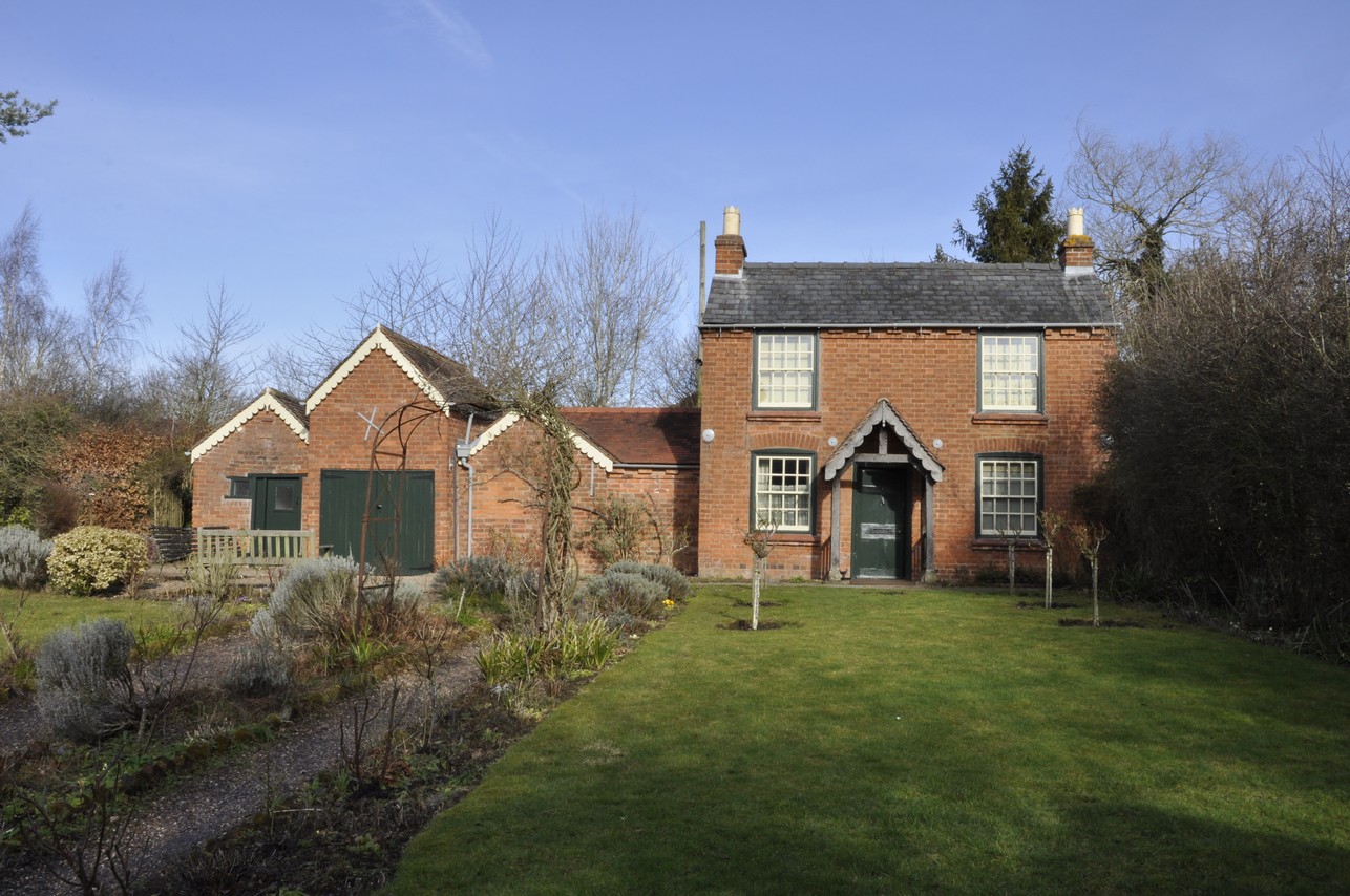
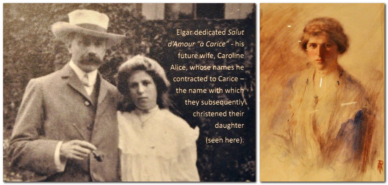
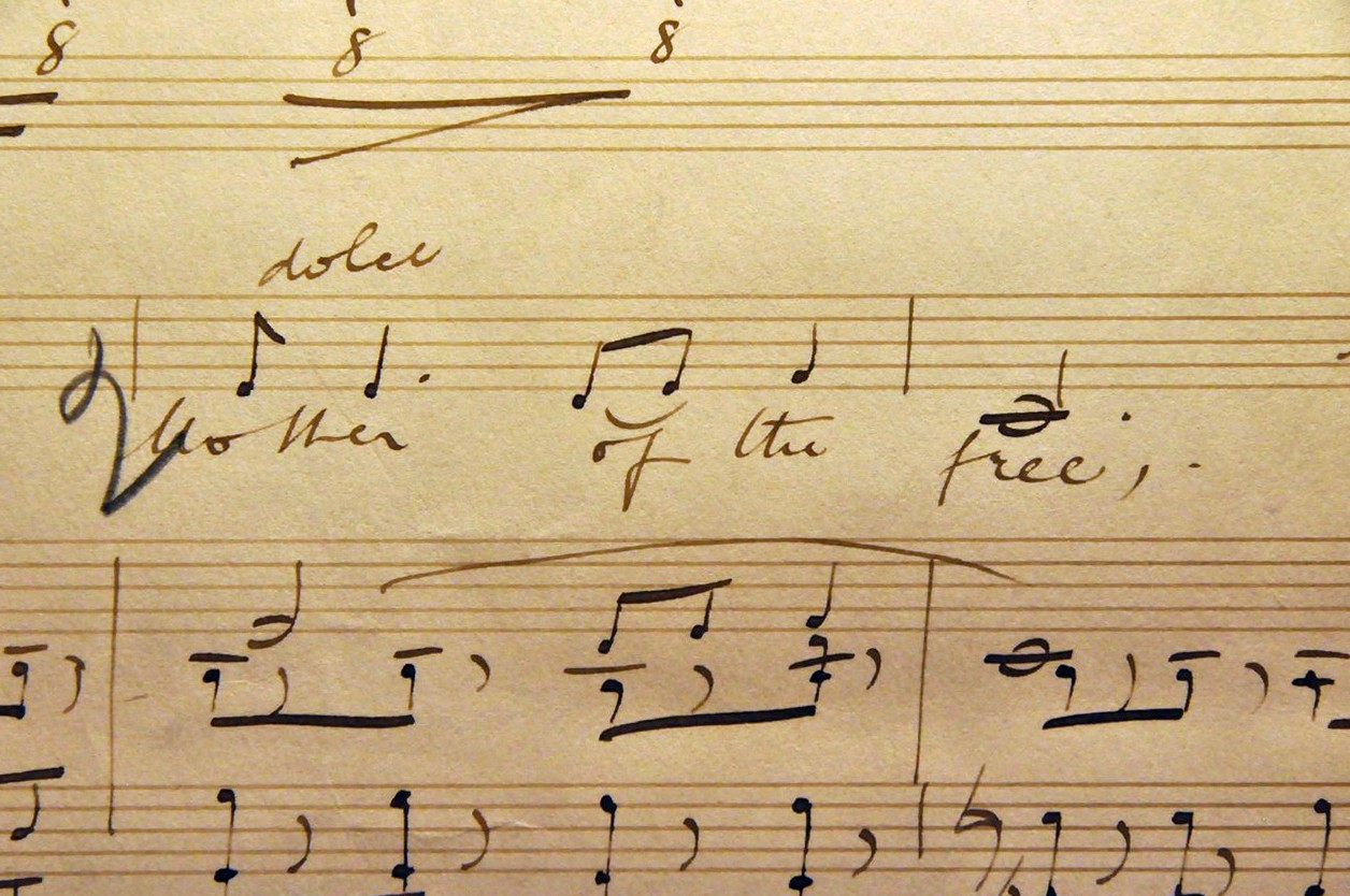
Elgar was born in June 1857 in a small cottage, The Firs, in the village of Lower Broadheath, a stone’s throw west of Worcester, and 20 miles southwest from our home in Bromsgrove. The cottage (formerly the Elgar Birthplace Museum) came into the care of the National Trust in 2016 following an agreement with the Elgar Foundation. Closed for a year for some refurbishment, and the addition of a tea-room at the existing Visitor Centre among other improvements, The Firs re-opened in September 2017.

As the weather forecast for Friday (yesterday) had looked promising from earlier in the week, Steph and I made plans for a day out. But where to go? Looking through the 2018 handbook I came across The Firs (which had not featured in the 2017 handbook for obvious reasons). And with the added attraction of a two-mile circular walk in Elgar country in the vicinity, this was just what the doctor ordered!

Our visit to The Firs was beyond my expectations and unbelievably moving, even bringing me to the point of tears as I watched the 15-20 minute film about Elgar in the Visitor Centre. Throughout our visit, but especially in ‘Elgar’s Study’, I really had the feeling of being in the presence of greatness, and I can’t recall ever having had that reaction before.


Elgar’s parents William and Anne had seven children, although two died young.

William was a piano tuner, and held a warrant from Queen Adelaide (wife of William IV).

Although Elgar moved away to Worcester with his family at the age of two, he retained a life-long attachment to The Firs. At the bottom of the cottage garden (see map) there is a lovely life-size sculpture of Elgar sitting on a bench (by Jemma Pearson) gazing through a gap in the hedge towards the Malvern Hills that he loved so much. It was commissioned by the Elgar Foundation in 2007 to celebrate the 150th anniversary of Elgar’s birth.

Elgar’s daughter, Carice (born in 1890) was the inspiration, in 1935, to acquire The Firs as a memorial to her father.


Entrance to the house is by timed tickets. There’s obviously not a great deal of space inside to accommodate too many visitors at a time.

Inside the entrance porch was a small room with an iron range for heating water and cooking. Today, the National Trust has decorated the room with contemporary though not original-to-the-house items, including a piano tuner’s set of instruments.

On the ground floor, the Parlour (dedicated to Carice Elgar) has a lovely piano, possibly played by Elgar.

At the top of the stairs is a room the full width of the cottage (perhaps earlier divided into two rooms) where Elgar was born. Two other rooms and this one have displays of various musical instruments, his sporting and scientific interests, and other personal belongings such as watches.

Elgar was apparently a keen cyclist, and on one wall of the Visitor Centre there’s a mural of an exuberant cycling Elgar. We were told, although this may well only be anecdotal, that Elgar once cycled from Malvern to Wolverhampton to watch his favorite football team Wolverhampton Wanderers play. A round trip of 100 miles!

Alice and Edward Elgar in 1890

Inside the Visitor Centre, an exhibition illustrates highlights from Elgar’s life and career. He married Caroline Alice Roberts in 1889. Her parents disapproved of Elgar—a ‘jobbing musician’—and did not attend their wedding in the Brompton Oratory in London. I hadn’t realized until yesterday that Elgar was a Catholic.

Alice (who died in 1920) was his inspiration, and early on in their relationship recognized his genius. And that leads to the second point I didn’t know. Elgar received no formal musical training. It wasn’t until 1899, with the first performance of the Enigma Variations, that his growing reputation as a composer was sealed.

In ‘Elgar’s study’ there are original scores of some of his most famous works, as well as the desk at which he worked.

Alice used to prepare the paper on which Elgar composed. Apparently, specially printed paper with the staves was not available, and had to be drawn by hand using the five-pointed pen you can see in a couple of the photos above.

Land of Hope and Glory, Mother of the free‘. Famous words by Arthur C Benson put to music in Elgar’s 1901 Pomp and Circumstance March No. 1, sung here by contralto Clara Butt.

A page from the original score of ‘Land of Hope and Glory’

Who hasn’t heard Land of Hope and Glory? It’s the theme accompanying high school and university graduations around the world. Our two daughters graduated from Manila International School in the Philippines in the 1990s, and it was used then.

Another large room in the Visitor Centre, the Carice Room, is used for concerts, and where we watched the film about Elgar. There was also a lovely exhibition yesterday of watercolors by Worcestershire artist David Birtwhistle.


After a spot of lunch—we even sat outside at one of the many picnic tables—we set off on our walk, which took just over an hour. The walk begins on a public bridleway just behind The Firs, and then crosses three fields sown with oilseed rape and winter barley. By the time we reached terra firma again at Bell Lane, it felt  as though we were carrying half of Worcestershire on our muddy boots.

And at this point I must come back to Vaughan Williams for a moment, because as we were walking across the barley field, and looking back towards Worcester Cathedral to the east, a skylark rose into the air in front of us, singing lustily throughout its ascent and as it glided slowly back to earth.

What a wonderful sight and sound, reminding me instantly of Vaughan Williams’s The Lark Ascending premiered in 1920, although originally written for violin and piano in 1914.


The staff and volunteers at The Firs were outstanding, and their friendliness and readiness to engage with us added to the enjoyment of our visit. As I said at the outset, we didn’t have any particular expectations when deciding to visit Elgar’s birthplace. I came away deeply affected by what I saw, heard, and learned, and I’m sure that the emotion will stay with me for many days to come. And, coincidentally, as I am finishing writing this post, while listening to Classic FM, Elgar’s Cello Concerto in E minor, Op. 85 has just been featured.


Taking in the central sierra . . .

September 1973. One of our first road trips in Peru, a circular route taking in Pisco on the coast south of Lima, before heading up into the Andes to Ayacucho, before heading north to Huancayo, and then back down to Lima. I’m sure the trip today is much easier than 43 or 44 years ago.

On the first day we drove south just as far as Pisco, spending one night there before attempting the next stage over the mountains to Ayacucho. Apart from the coastal Panamerican Highway and the road from Huancayo back to Lima, which were paved, the others were dirt roads in various states of repair. At the highest point on the road between Pisco and Ayacucho, we encountered one particularly stretch of muddy road that I thought we just might halt our trip. But with some expeditious maneuvering, I managed to extricate us from mud almost up to the axles.

The road up from Pisco.

If I remember correctly, the road dropping down to Ayacucho seemed to last forever, a long and relatively gentle decline. It was above Ayacucho where I took this photo, one of my favorites in all I took during our three years in Peru.

Staying at the turista hotel just off the main square, we spent a couple of nights in Ayacucho, and enjoyed its pleasant climate, lying as it does in a wide, fertile valley, just below 2800 m above sea level.

This slideshow requires JavaScript.

North from Ayacucho the road crosses a wide, high altitude plain, dotted everywhere with cacti. Further north, it follows the steep-sided valley of the Mantaro River, and is carved into the side of the mountain. Maybe it has been widened today, but back in the day, it was so narrow that traffic flow was one-way only on alternate days. This had to be factored into our road trip planning of course.

This slideshow requires JavaScript.

It was an easy day’s drive between Ayacucho and Huancayo, and we spent a couple of nights there. As the International Potato Center (CIP) had its highland experiment station close to Huancayo in the Mantaro Valley, and Steph and I would travel there almost every week during the potato growing season between November and May, we took the opportunity of passing through Huancayo to check a few work-related items before passing through on our way back down to Lima along that familiar road that crosses Ticlio at almost 5000m.

This trip must have lasted about seven days, maybe eight. With the others we made, as well as the various potato collecting trips that I made as part of my work, we were fortunate to explore many parts of this beautiful country.

Here is a list of those trips:


And pigs might fly . . .

Steph and I made two road trips together to the small town of San Ramón (see map), that lies at just over 800 m on the eastern slopes of the Andes in the Department of Junín.

Nothing particularly special or interesting in that, you might ask, especially if you know the region. The International Potato Center (CIP) opened an experiment station there in the 1970s, as somewhere it could evaluate potato breeding lines against several pests and diseases that appeared more regularly at this site than at higher elevations. But also for testing potatoes in their ability to grow under higher temperatures than usual for potatoes, a temperate crop that evolved in the Tropics. This emphasis on adaptation to high temperatures, with the aim of potentially expanding potato production worldwide into less favorable environments, was work I would continue once I moved to Costa Rica in 1976.

San Ramón today has a population of 30,000 inhabitants but was very much smaller when we first visited. It was not normally on our itinerary, since Steph’s and my work only took us to Huancayo high up in the central Andes, at over 3000 m.

Our first trip, in August 1973 (with CIP plant pathologist John Vessey and physiologist Ray Meyer) was just a few weeks after Steph joined me in Peru. This was our first experience of the hot and humid lowland tropics. Little did we imagine that just a few years later (from 1976) we would spend almost five years in Costa Rica living under those conditions in Turrialba, nor that almost two decades later we would move to the Philippines for 19 years.

Our second and short vacation trip was in September 1974.

I’ve been back only a couple of times, once in early 1976 before we headed off to Costa Rica, and another¹ in the mid-1980s when, working at The University of Birmingham, I had a research project with CIP, and took the opportunity of a visit to Lima to travel from Huancayo to San Ramón.

Dropping down to San Ramón the only road passes through the town of Tarma, famous for its flower production. What a delight. Higher up, the road sweeps round broad valleys with it patchwork of fields, one of the most attractive views I think I’ve seen in all my travels across the Andes.

Below Tarma, the valley narrows, and winds its way beside a fast flowing river (that becomes the Chanchamayo River beyond San Ramón), with numerous tunnels carved through the rock, and barely wide enough in places for two vehicles to pass. There are steep precipices into the river below at numerous locations.

And given that the San Ramón region and beyond is (was) a particularly important fruit-growing one (especially for papayas), there was always a constant stream of lorries loaded with fruit grinding their way out of the valley to climb over Ticlio (at almost 5000 m) before dropping rapidly to Lima on the coasts.

Steph’s first trip to Huancayo (and San Ramon) in August 1973.

On the second morning of our September 1974 trip, we set off after breakfast along the Chanchamayo River towards La Merced, stopping frequently to look at the vegetation, explore the river bank, and take photos. It’s hard to imagine that La Merced now has a population approaching 170,000. Beyond La Merced we had thoughts of eventually reaching Oxapampa, but as the road deteriorated so did our expectations of being able to travel there and back in a single day. With some regret we turned around. Oxapampa was (is) an interesting community, founded in the 19th century by German immigrants, and retaining much of that influence today.

Our trip on the third day was much more eventful. Following a suggestion by John Vessey, we decided to take advantage of the local light aircraft flights from San Ramón servicing communities further out in the lowland areas (the ‘jungle’) and visit one such beside the Pichis River, Puerto Bermúdez (some 550 m lower in altitude than San Ramón). Today, Puerto Bermúdez is connected by road to La Merced and San Ramón, a drive of some 176 km, and about four hours. There was no road in 1974, and flights were the only option. From satellite images, the town does not appear to have an airstrip anymore. What looks like a former airstrip is flanked by buildings and criss-crossed by streets. Maybe with the road now reaching the town, an air bridge to San Ramón or other towns is no longer economically viable.

Having purchased our tickets, we arrived at the airfield early the next morning, and found ourselves squeezed into the rear seats of a single engine plane (probably a Cessna) for the 45 minute flight to Puerto Bermúdez. We were scheduled to return mid-afternoon, and had decided that we’d try and rent a boat for a trip along the river.

In 1974, Puerto Bermúdez was a very small settlement, and the area is home to one of Peru’s largest indigenous communities in its Amazon region, the Asháninka².

We soon found somewhere to buy a quick cup of coffee, and someone who would rent his boat to us for several hours for a trip along the Pichis, a river that flows north to join the even bigger Ucayali River south of Pucallpa, being some of the headwaters of the River Amazon.

In this gallery of photos, you can see the type of dugout canoes that are common along the river, with their long shaft outboard motors. In the distance along the river you can also see the Andes rising in the west. And also some of the communities we observed along the riverbanks, and the rafts carrying fruits. This was our first experience of an environment like this, and we thoroughly enjoyed ourselves. Everyone was most friendly.

After a quick bite to eat for lunch, we headed back to the airstrip for our mid-afternoon flight back to San Ramón.

And that’s when we had our next surprise. There was an aircraft waiting for the return flight. We were the only passengers. But the aircraft had no seats for us. There was some ‘freight’ to take: several dead pigs that were loaded along with empty beer crates that we were to use as seats. No seat belts!

Communicating with base back in San Ramón, the pilot told us that the weather had ‘closed in’ and that our departure would be delayed. And there we sat, looking westwards towards the Andes and wondering when we would be able to take off. After about an hour, the pilot told us that there was still ‘weather’ along the proposed return route, but ‘bugger it’ or words to that effect in Spanish, he said we should leave, and we’d better climb aboard if we wanted to return to San Ramón that same day.

With some trepidation—that I can still feel after all these years (I’ve never been the world’s best flier)—Steph and I climbed aboard, settled ourselves on our respective beer crates (or maybe they were cases of beer), and held on for dear life to anything we could as the plane hurtled down the runway and took to the air.

All was well for the first half of the flight. We gained height easily (after all the plane was carrying quite a light load  and I was very much lighter than I am, unfortunately, today). We could see the foothills of the Andes approaching, with rain squalls across our path. Needless to say things became rather more uncomfortable as we crossed that weather system, and bounced our way into San Ramón. But we lived to tell the tale.

Given the chance to make a journey like that again, I’d probably decline. The enthusiasm of youth, the risk taking. In any case one might hope that today, safety regulations are much more assiduously applied. The only time I’ve ever shared a flight with three dead pigs.

~~~~~~~~~~~~~~~~~~~~~~~~~~~~~~~~~~~~~~~~

¹ The 1980s were the Michael Jackson years. The singer, not me. Arriving at our hotel in San Ramón, it didn’t take long before a very large crowd of children had assembled outside the hotel and chanting ‘We want Michael Jackson‘. Some mix-up!

² Puerto Bermúdez’s Asháninka suffered during the years of the Sendero Luminoso (Shining Path) guerrilla insurrection of the 1990s, and many inhabitants of the town were massacred.

Heading south to the highest lake in the world

At 3812 m above sea level, Lake Titicaca straddles the border between Peru and Bolivia, and is the ‘highest navigable lake in the world’. It’s more than 1200 km south from Lima by road, and was the destination of a trip that Steph and I made in November 1974. Our first idea was to drive to La Paz, the capital of Bolivia, some 256 km southeast from Puno. However, we decided that would be one sector too far in the time we had available.

Most of the drive follows the Panamericana Sur for 850 km through a coastal desert, one of the driest in the world.

The highway crosses the Nazca Plain about 450 km south of Lima, and is the site of the world famous Nazca Lines (yet another UNESCO World Heritage Site in Peru!), ancient geoglyphs that can only be appreciated from the air. Sadly, we never took the opportunity for a flight over the Lines¹.

The Nazca monkey. Photo taken by renowned archaeologist Maria Reiche in 1953.

Much further south, at Camana, the road branches north towards the southern city of Arequipa, some 180 km away, and at an altitude of around 2330 m. Puno is reached from Arequipa after a climb to well over 4000 m before dropping to 3800 m on the shore of Lake Titicaca, crossing (among other locations) the Reserva Nacional Salinas y Aguada Blanca (and its flamingos).

We had already decided to drive ourselves just as far as Arequipa, then take a colectivo (a communal taxi) for the rest of the journey to Puno, and use taxis to move between the various sites we wanted to visit around Puno. On reflection we could have taken our VW the whole distance given some of the other trips we made around Peru and the state of some of those roads. From Arequipa to Puno we left the asphalt behind, travelling on a graded dirt road.

We spent the first night in Nazca, traveling on to Camana and its turista hotel on the second day. Like most of our travels there were frequent stops to admire the landscape, take photos, and investigate the local flora, especially the various cactus species, a particular hobby of Steph’s at that time.

This cactus, possibly an Echinocactus species, was less than 3 inches in diameter.

The highway crosses quite a number of rivers that flow down from the Andes. In the desert, and along the valleys themselves, irrigated rice cultivation is quite important. I had no idea when looking at these rice paddies in the 1970s that I’d be working on that crop across the other side of the world two decades later².

In Arequipa, we found a garage where we could leave the car safely for a few days while we traveled on to Puno. And then spent the next day and a half walking around the city to enjoy some of its sites.

Arequipa, founded in 1540, is (was) an elegant city, with a skyline dominated by the symmetrical cone of the Misti volcano, rising to over 5800 m. It is seasonally snow-capped, but with the effects of climate change affecting so many mountain ranges in the Andes today, I wonder to what extent Misti now has any snow cover at all during the year.

There were two sites we wanted to visit: the Basilica Cathedral, located on the north side of the Plaza de Armas, Arequipa’s central square. It has a facade of beautifully carved white stone, like the cathedral in Cajamarca that we visited in June 1974.

It was constructed over more than two centuries beginning in the 1540s. Progress was interrupted many times by volcanic eruptions and earthquakes, and the church had to be reconstructed several times. As recently as June 2001, one of its towers was toppled by a powerful earthquake that shook southern Peru. It is a building of great beauty, and dominates the Plaza de Armas.

A short distance north of the Plaza de Armas, the 16th century Dominican Convent of Saint Catherine (Monasterio Santa Catalina) is a quiet haven among the bustle of a busy city, and open for tourists to visit. Well, that was the situation four decades ago, so it must be even more so today. It has the feel of a small Spanish village, with winding streets, open doorways off to the side, and colonnaded hidden courtyards. And all decorated in a glorious umber.

The nuns could not receive visitors inside the convent, but could communicate with the outside world through grills. Natural light brightens the visitors’ corridor through skylights hewn from rock crystal. Inside the convent there are beautiful murals dating from as early as 1516. That’s interesting, because in the article about the convent on Wikipedia linked to above, the founding date is given as 1579, and Arequipa was not founded until 1540. Maybe some early buildings were incorporated into the convent. Nevertheless, there are some date inconsistencies I need to check further.

In Puno, there were three attractions we wanted to visit: the harbour and its large steamships; the floating islands made from the local totora reeds (Schoenoplectus californicus subsp. tatora), and home to a community of indigenous Urus; and the pre-Incan archaeological site of Sillustani, some 32 km northwest from Puno towards the airport town of Juliaca.

Some of the vessels that ply (or used to ply) Lake Titicaca are remarkable for their size. So how did they come to be sailing around the lake? The SS Ollanta was built in 1929 in Kingston upon Hull in England, in kit form, and sent out to Peru in pieces. The original Lego! Transported from the port of Mollendo to Puno by rail, it was riveted together on the shore of Lake Titicaca, and launched in 1931. It is still sailing today, but no longer on any scheduled services.

Tourism was, and must still be, a significant source of income for the Uru community that lives on the totora reed islands just offshore from Puno. Steph and I took the short motor boat trip from Puno to spend a couple of hours there. It is quite a remarkable community, seemingly self-sufficient, and getting around on their beautifully-crafted reed boats (the inspiration for Thor Heyerdahl’s Ra II expedition).

Given my interest in potatoes, I was fascinated to come across this brilliant example of potato hydroponics. Now that’s a good use for an old totora reed boat. Ingenious!

Although we didn’t make it into Bolivia, we did head out along the south shore of the lake towards the border, as far as Juli, just over 80 km southeast from Puno. As with so many small communities in the Andes, the town is dominated by a Catholic church, that we took the opportunity of visiting. The opulence of its interior was quite unexpected.

Our final visit in the Puno area was to the pre-Incan cemetery of Sillustani constructed by the Qulla people on the edges of Lake Umayo, and comprising a series of round towers called chullpas. The stones making up the chullpas are smooth and regular is shape, and one is left, yet again, with a sense of awe, at how such beautiful pieces of architecture were actually constructed. Interestingly, the Qulla are an indigenous people of western Bolivia, northern Argentina, and Chile. Sillustani must have been at the northern limit of their territory and range.

And then the vacation was over and we were headed back to Arequipa, to pick up our car and drive to Camana on the coast for an overnight stop. I think we made it back to Lima from there is one very long day of driving.

Besides this visit, I’d been in Puno on two previous occasions. One of my abiding memories was to seemingly acquire a taste for the algarrobina cocktail, made with Pisco. While I love a delicious Pisco sour, the thought of this rather sweet concoction now sends shivers down my spine. Happy days!

~~~~~~~~~~~~~~~~~~~~~~~~~~~~~~~~~~~~~~~~

¹ The Greenpeace delinquents who staged a protest on and defaced the Lines in December 2014 should have faced the full force of the law.

² In about 1996, the then President of Peru, Alberto Fujimori (now disgraced and serving a prison term for various human rights crimes, among others), visited the International Rice Research Institute (IRRI) in Los Baños, Philippines. I showed him around the genebank, and then joined discussions with IRRI’s Director General George Rothschild about rice production in Peru. Peru grows a number of IRRI varieties that have fallen out of favor in other parts of the world because of their susceptibility to pests and diseases. These, including IR43 and IR48 were less affected in Peru.

Coast and mountains – remembering a 1974 road trip in northern Peru

During the three years that Steph and I lived in Peru between 1973 and 1976, we made several long-distance road trips. In those days, once you turned off the main coastal highway, the Panamericana, you left the asphalt behind and traveled only on graded dirt roads.

We also drove a car—a Volkswagen Variant—that had good clearance, and traveled comfortably on these roads. We had also fitted heavy-duty shock absorbers as well as a good set of radial tyres. So we were never concerned about leaving the paved highways. In fact, we often spent time during the weekends visiting one of our favorite destinations on the eastern side of Lima, climbing route 116 into the Andes mountains in the Santa Eulalia valley near Chosica. We enjoyed hunting for wild potatoes on the higher slopes.

In the Santa Eulalia valley, hunting for wild potatoes

In May 1973 and May 1974 I’d made two trips into the Departments of Ancash and La Libertad, and Cajamarca, respectively to collect cultivated varieties of potatoes to add to the world germplasm collection curated by the International Potato Center (CIP) for which I was working as a germplasm expert and Associate Taxonomist. Steph also worked in the germplasm program as an Associate Geneticist.

Both trips took me through some stunning landscapes, and interesting cities like Cajamarca. So, in June 1974 we made an eight-day trip to visit some of those same places. Joining us on the trip were our friends and fellow Brits, John and Marion Vessey. They were our witnesses when Steph and I married in October 1973, in the Lima suburb of Miraflores.

After our wedding ceremony in the Miraflores Municipalidad, we enjoyed lunch at the Granja Azul near Chosica.

John also worked as a plant pathologist at CIP on the same bacterial wilt disease that I’d spend several years studying when I transferred to Costa Rica in 1976. John’s work often took him to Cajamarca and beyond, almost always by road, a round trip of almost 1700 km.

Anyway, our plan was to visit the Callejon de Huaylas in Ancash, see the highest mountains in the country, and from there returning to the coast and traveling north to Cajamarca via Trujillo, taking in several interesting archaeological sites on the way both in the mountains and on the coast.

This was a round trip of almost 2800 km or thereabouts, and John and I shared the driving. Setting out from Lima early one morning, our first destination was Huaraz, the departmental capital of Ancash, in the heart of the Callejón de Huaylas, with the highest mountains of the Cordillera Blanca on the east side (including Peru’s highest peak, Huascarán) and the lower Cordillera Negra on the west (or coastal) side.

Looking north along the Callejón de Huaylas towards Nevado Huascarán.

The gallery below shows Cordillera Blanca mountains at the southern approaches to the Callejón de Huaylas, near the turn-off to Chavín de Huántar. The last image in the gallery shows the Cordillera Negra on the western side of the Callejón de Huaylas.

The Callejón de Huaylas runs north-south, parallel to the coast, and was the site of a major earthquake in May 1970 that destroyed the towns of Ranrahirca and Yungay north of Huaraz, and killing tens of thousands of inhabitants. The gallery below shows where the landslide fell from Huascarán, with boulders the size of houses, obliterating Yungay and Ranrahirca. In Yungay, just a few palm trees and a statue of Christ at the cemetery were all that remained of the town in 1974.

We spent three nights in the turista hotel in Huaraz, traveling on the day after our arrival to Yungay, and then higher still to a lake nestling in a valley beneath Huascarán, Laguna de Llanganuco at 3850 m above sea level.

The day after we made a side trip of just under 100 km each way to the east of the Cordillera Blanca, to visit the ruins at Chavín de Huántar, a UNESCO World Heritage Site, built by a pre-Inc culture at least 3000 years ago.

On the journey to Chavín (I was driving at the time), and only a few km short of the town, I was coming round a blind bend, and found myself facing some difficulty to avoid a rather large rock in the middle of the road. So I attempted to straddle it, but was unsuccessful; some part of the chassis connected with the rock. It sounded bad, but a close inspection underneath the vehicle showed no visible damage, so we carried on. The next morning we loaded the car and set out due west from Huaraz to cross the Cordillera Negra before dropping down to the coast near Casma, where we planned to stop at the archaeological site of Cerro Sechín.

As we climbed out of Huaraz, I could hear unnerving creaks and groans emanating from behind me. So after about 30 minutes we stopped to make another inspection underneath. To my horror I saw that there was a visible crack in one of the shock absorber mounts. I could see daylight! I hadn’t realised just how hard I’d hit that rock the previous day.

Well, we couldn’t continue with that sort of damage, so I carefully reversed the car and we returned—slowly—to Huaraz and found a repair shop alongside the road. When the mechanic jacked up the car, the absorber mount gave way. In such a remote location there was no chance that any dealer would have the exact mount in stock. However, all was not lost, and with great skill the mechanic welded a piece of steel around the fracture, taking less than an hour to make the repair. And we set off, much relieved with a vehicle almost as good as new, although we’d lost about 4 hours in total, putting back our destination for the night at Trujillo further up the coast until after dark.

Cerro Sechín, a few km inland from the Casma, is a very unusual site. Excavations began there 80 years ago, and the site has been dated to almost 4000 years. Its outstanding features are the stone bas-reliefs depicting victorious warrior-priests and their dismembered victims. What do they all mean? Some suggest that this is the site of a battle, others that it commemorates the vanquishing of a rebellion. Perhaps we’ll never know. What I can say is that I never saw any other archaeological site in Peru with any similarity to Sechín.

After spending a night in Trujillo, we took a morning to visit the extensive ruins of Chan Chan just west of the city, whose mud walls and reliefs have survived the ravages of time in this extremely arid desert. Dating from the mid-ninth century AD, it was the capital of the pre-Incan Chimú, who were defeated by the Incas in the fifteenth century. Chan Chan is now a UNESCO World heritage Site.

Along the coast, and even in some of the valleys heading into the mountains, there are mud brick pyramids, known as huacas standing proudly in the landscape, reminders of ancient pre-Incan cultures that once thrived there.

Huacas erected in coastal valleys.

In 1974, the highway to Cajamarca diverged from the Panamericana just north of Trujillo. It climbed along a fertile valley with rice cultivation alongside the river, then crossing over into the valley of Cajamarca at around 2500 m or so.

I’ve visited Cajamarca three times. It is undoubtedly one of my favorite cities in the whole of Peru. Located in a broad and fertile valley, it has an agreeable climate. No doubt it has expanded considerably since I was last there in about 1988.

Cajamarca (from the north) in the early morning light. You can see the steam from the Inca baths on the east of the city.

The beautiful Cathedral of Saint Catherine (Santa Catalina) occupies the northwest side of the main square, the Plaza de Armas. Begun in the seventeenth century, it has the appearance of a half-completed building. But this does not take away anything from the exquisite construction and carving of white stone on the entrance facade.

The Plaza de Armas, with the Cathedral of Sant Catherine on the left.

To the east of the city, by about 3 km lie the Baños del Inca, a site of geothermal hot springs where we luxuriated in the spa’s deep and soothing waters.

It was also in Cajamarca that the army of the last Inca emperor Atahualpa was defeated by Francisco Pizarro and his band of adventurers. Captured and imprisoned by Pizarro, Atahualpa was executed in July 1533 bringing an end to the illustrious Incan culture, and the subsequent colonisation not only of Peru but much of South America by the Spanish.

I’m sure we must have stayed at the turista hotel in Cajamarca close to the Plaza de Armas. Around the square were many small restaurants where, as in so many Andean towns and cities, you could enjoy an excellent and reasonably-priced meal. But Cajamarca is famous for one dish, and a sweet one at that: leche asade (crème caramel), one of my favorite desserts. There was one restaurant on the northeast corner of the Plaza renowned for its leche asada.

After a couple of nights in Cajamarca, we headed back down to Trujillo on the coast, and made it back home to Lima the next day. Quite an eventful trip, taking in some breath-taking sites and landscapes. As I reflect on all those magical Peruvian experiences, I realise more than ever, just what attracted me to want to visit all those years ago when I was just a small boy. Ambition fulfilled, and beyond expectations!