Following our epic drive in mid-June from Maine to Minnesota (after already having crossed Massachusetts, Vermont, and New Hampshire, and explored parts of western Maine for six days), Steph and I settled into a couple of weeks of relaxation with our elder daughter Hannah and family in St Paul, MN before heading back to the UK on 10 July.
My son-in-law, Michael, is – like me – a beer aficionado, and keeps a well-stocked cellar of many different beers. It’s wonderful to see how the beer culture has blossomed in the USA, no longer just Budweiser or Coors. I had opportunity to enjoy a variety of beers. Those IPAs are so good, if not a little hoppy sometimes. However, my 2018 favorite was a Czech-style pilsener, Dakota Soul from the Summit Brewing Company based in St Paul.
Relaxing in St Paul was also an opportunity catch up with some of my blogging, while Steph spent time in Hannah’s garden making sure everything was coping with the very hot weather. Notwithstanding the regular watering, we did experience a couple of quite spectacular downpours the like of which I haven’t seen for some time.
And our lively grandchildren, Callum (eight just two days ago) and Zoë (6) kept us on our toes. For one of the two weeks we stayed in St Paul, I was their summer camp chauffeur, dropping them off at the bus just after 8 am each day, and picking them up late in the afternoon. We were also ‘babysitters’ over six days and five nights. That’s the first time we’ve taken on this role; it was the first time that Hannah and Michael left the children with grandparents for more than just an overnight stay, while they celebrated their 40th birthdays with a visit to California’s Napa Valley.
Outcome? I think Callum and Zoë survived us – no permanent harm done!
There’s quite a lot of ambiguity associated with looking after someone else’s children – and they know it! Even though it was made clear to both that ‘Grandad and Grandma were in charge’, you’re often faced with situations asking yourself how Mum and Dad would react. Obviously we haven’t looked after small children for more than three decades since Hannah and Philippa were small. Although we had TV in the 1980s, there were no video games, or subscription channels like Netflix offering up a continuous menu of cartoons.
Both Hannah and Philippa had quite a large circle of friends within easy distance of home, some just a few doors away. So whenever the weather was fine – or even if it was not – one or the other would be round a friend’s house, or the friends at ours. It’s a sign of the times but ‘play dates’ have to be arranged for both Hannah’s and Philippa’s children. This is not only a reflection of busy lives for Mums and Dads, but also that no friends live next door.
We had fun with Callum and Zoë, although they might not perhaps reflect well on the occasions when I had to ‘lay down the law’. We went bike riding (they did the riding while we followed on foot), and explored the fascinating glacial potholes at the Interstate State Park 53 miles northeast from St Paul beside the St Croix River at Taylors Fall.
Afterwards we spent time at a splendid children’s playground at Stillwater. We ate out one night, went out for breakfast on the Sunday, and had a BBQ. Here are some more photos of that outing.
Grandma Mary (Michael’s mother) took the children to the Minnesota Zoo one day so Steph and I could enjoy a day at the Minnesota Landscape Arboretum (here are the 2018 photos), somewhere we have visited a couple of times in the past.
Beautiful echinaceas, a typical species of the prairies
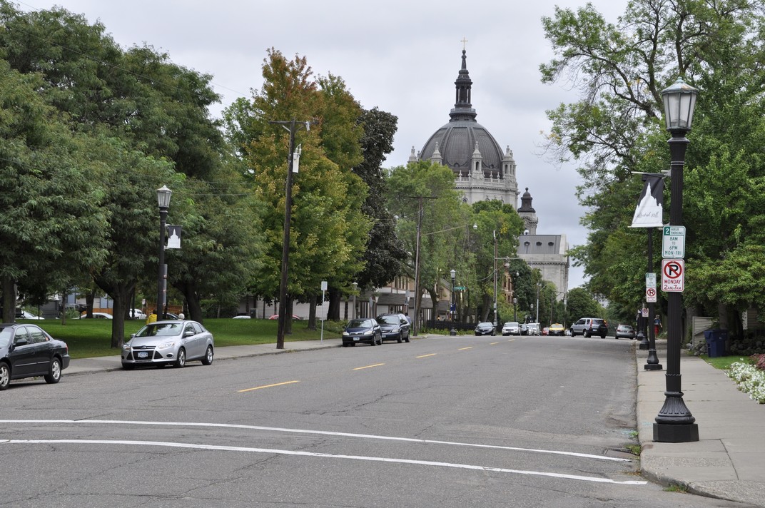
And any visit to St Paul would not be complete without checking out the Marjorie McNeely Conservatory at Como Park (map).
We’ve been going there since 2006 when it was the venue for Hannah and Michael’s wedding. The floral displays change with the seasons, and we always enjoy seeing what the gardeners have prepared for their many visitors. This summer’s display was much more subdued compared to other years.
May 2006
December 2007
July 2016
June 2017
June 2018
I would certainly recommend a visit to Como Park if you’re ever in St Paul. There is also a small zoo and fun fair, very popular with the children.
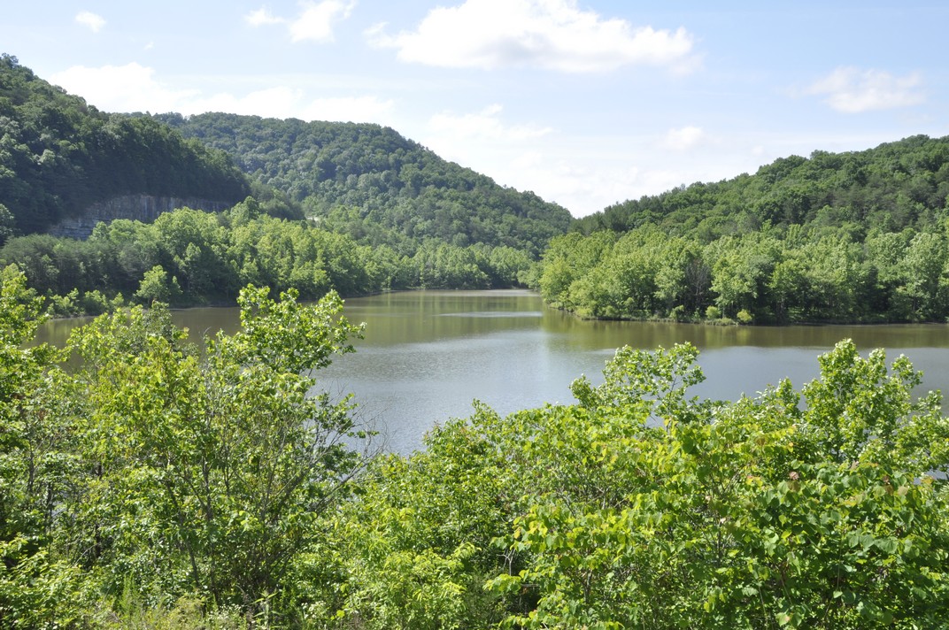
The Mississippi River is just 50 m from Hannah’s front door, but at least 50 m below. There are some lovely walks and parks along the river, Hidden Falls Regional Park, about a mile from Hannah’s, being one of them. But the river was high this year, with flooding closing several of the walks nearby. The St Croix River at Stillwater was the highest we have ever experienced.
Beside the Mississippi at Hidden Falls Regional Park.
The St Croix River at Stillwater. That’s Wisconsin on the far (east) bank.
Finally, this commentary about relaxing in Minnesota would not be complete without mention of Hobbes, a lovely ginger rescue cat who has his moments, going from sweet and docile to full on attack mode at the drop of a feather. But over our time at Hannah and Michael’s he did begin to relax with us and, more often than not, this is how he spent much of his time.
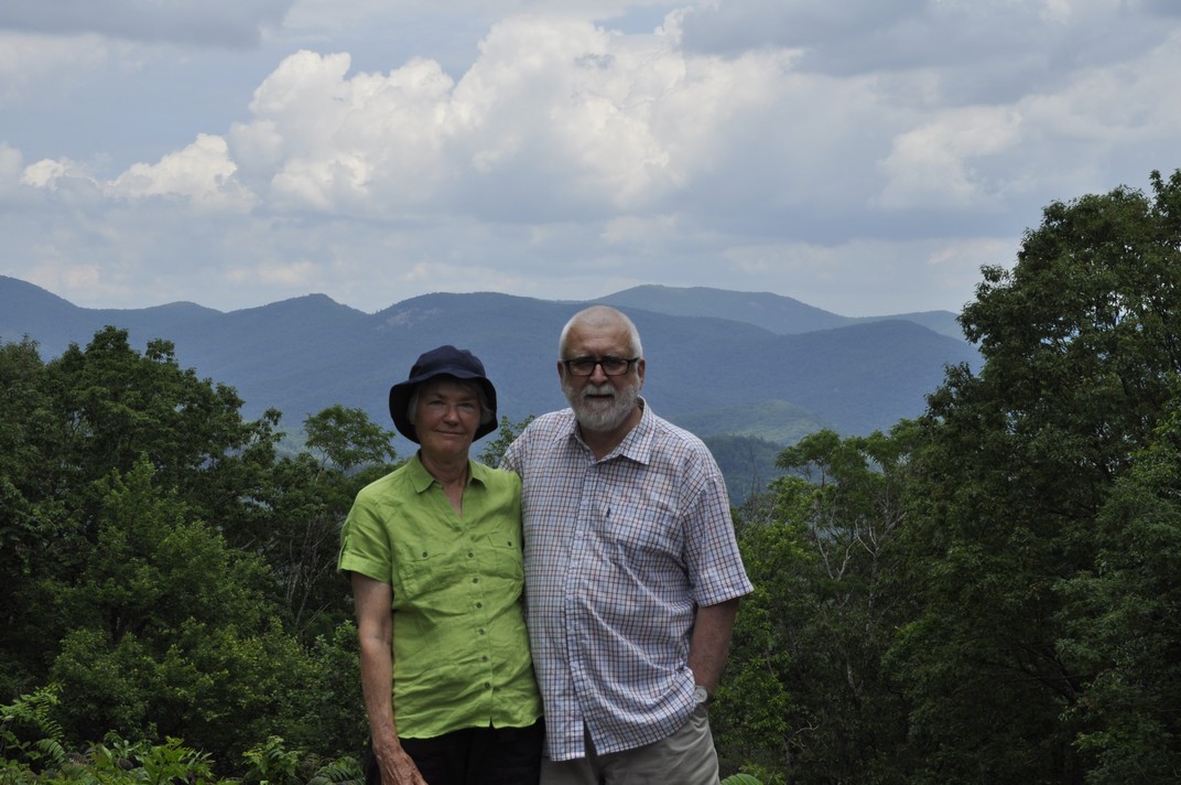
Compared to the mountain ranges in the west of the USA, Mt Washington (at 6288 ft – 1917 m) and nearby peaks in the Presidential Range of New Hampshire’s White Mountains are mere foothills. From their base, however, they still look pretty impressive. Mt Washington is the highest mountain in the northeastern USA and experiences some pretty spectacular weather.
Steph and I got our first glimpse of Mt Washington as we crossed New Hampshire recently on the first part of our road trip that also took us through Massachusetts and Vermont on our way to Maine to spend a week there with our elder daughter Hannah and her family, who had flown in from Minnesota.
I’d chosen a route from Burlington, VT taking us north towards the Canadian border, then dipping down to the southeast through the White Mountains close to Bretton Woods, site of the momentous 1944 conference that aimed at regulat[ing] the international monetary and financial order after the conclusion of World War II. The conference led to the founding of the World Bank (or International Bank for Reconstruction and Development) and the International Monetary Fund.
And as we skirted a bend on US302, heading southeast, there was the famous hotel off to the left, nestling under the Presidential Range. In the middle was Mt Washington (just left of center in the photo below), clearly higher than surrounding peaks, and on which we could just make out some infrastructure we later discovered to be part of an observation station.
During our week in Maine we made several excursions, and one of those was the seven mile drive on the Mt Washington Auto Road that takes you to just below the summit, from 1500 ft the park entrance west off NH16 (White Mountain Road).
Amazingly, construction of the Auto Road (originally the Carriage Road) commenced in 1854, and was completed in 1861, opening to the public on 8 August that year. Over the past 157 years, more than 4 million tourists have reached the summit.
The fastest ascent on foot (in 2004) took just a few seconds short of 57 minutes (and only seven minutes quicker by bike). By car, Mt Washington has been climbed in just 6 minutes 9 seconds (in 2014). We took rather longer, at least 30 minutes, as we stopped whenever possible to enjoy the spectacular views, as well as negotiating some of the curves rather gingerly.
The road is paved most of the way, although near the summit there is a short gravel section.
The summit can also be reached by a cog railway! The train ascends on the western flank of the mountain; the station is situated a short distance beyond the hotel at Bretton Woods.
The cog railway, heading ‘vertically’ up the mountain can be seen just right of center.
Apparently the summit is hidden in clouds for about 60% of the year. Not so on the day of our visit. We couldn’t have asked for better weather, and the views, in all directions, were just awesome.
That’s Bretton Woods in the distance . . .
It wasn’t too windy either, blowing between 40-60 mph. Even so, we struggled to keep upright at the summit signpost.
60 mph is nothing on Mt Washington. On 12 April 1934 the world record wind speed (observed by humans) was recorded at 231 mph! Can you imagine that? Besides a small cafeteria, there is a small but interesting exhibition at the summit, with some of the instruments used and observations recorded on that momentous day 84 years ago.
I guess we spent a little under two hours at the summit, enjoying the panoramas in all directions. We couldn’t have hoped for a better day. Once we were down, there was time to relax in the sun, enjoy a picnic, and even take forty winks. We were even given a certificate for ascending the mountain.
So, if you are ever in the vicinity, and the weather looks half decent, I’d recommend the drive up the Auto Road. We weren’t disappointed.
~~~~~~~~~~~~~~~~~~~~~~~~~~~~~~~~~~~~~
Here is a link to a bigger album of photos taken at Mt Washington.
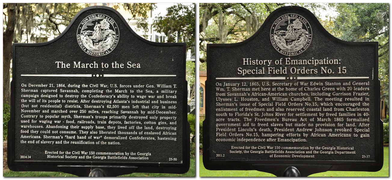
William Tecumseh Sherman. Red-haired. Union Major-General in the American Civil War. Outstanding military strategist. Commander of the Army of the Tennessee. Mastermind of the March to the Sea (that culminated in the capture of Savannah, GA) and the Carolinas Campaign, both of which contributed significantly to the end of the Civil War in 1865.
Born in 1820, Sherman was a native of Lancaster, Ohio (map). I wish I’d known that just a few weeks ago.
As Steph and I crossed Ohio on our road trip from Massachusetts to Minnesota, we passed through Lancaster on the route I’d planned from Canton, OH to Bloomington, IN. I do recall saying to Steph how prosperous it looked compared to others.
I only learned of the Sherman connection from a biography that I’m reading right now¹, and which I picked up at my favorite bookstore in St Paul, Half Price Books on Ford Parkway in the Highland Park area. This year I added three more to my American Civil War collection.
I could have made the Sherman connection in Lancaster had I looked in my rear-view mirror at the right moment, but I was too intent on following the sat nav instructions. There, on a west-facing wall on Main Street (we were heading west) is a full height mural of Sherman. I didn’t see it, more’s the pity. I would have stopped to explore further.
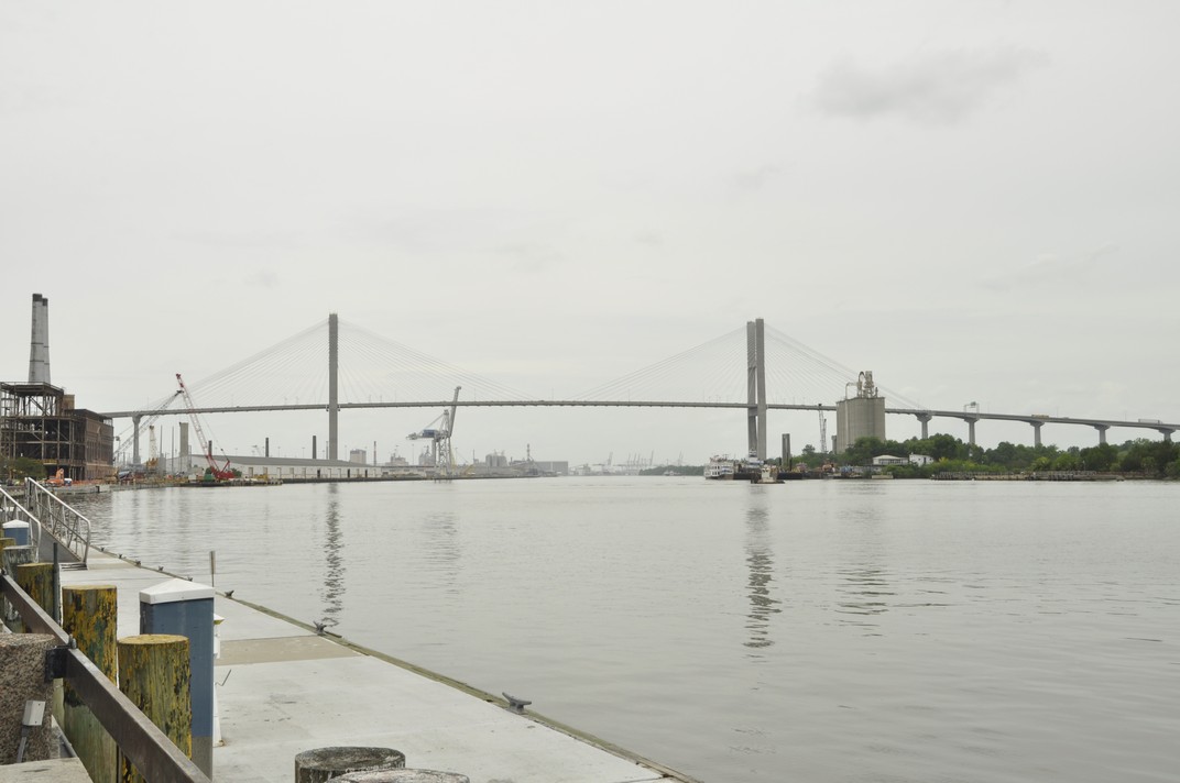
During the first part of our 2017 USA road trip, from Atlanta, GA (which Sherman ransacked in 1864) to Savannah, our route more or less mirrored Sherman’s March to the Sea. In the historic neighborhoods of Savannah his name appears on several historical markers, as you might expect.
And there were other surprises. Just 18 miles northeast of Lancaster is the small community of Somerset, OH. It has a lovely town square, in the middle of which is an impressive statue of a mounted soldier, Philip Sheridan, a Major-General of Cavalry during the Civil War, who was eventually promoted to four star rank. Sheridan grew up in Somerset. After the Civil War he served on the Great Plains during the Indian Wars. He was also instrumental in developing Yellowstone as a national park.
Despite its incredibly bloody outcomes and destructive consequences, the American Civil War, 1861-65 holds a certain fascination. To a large extent, it was the first war to be extensively documented photographically, many of the images coming from the lens of Mathew Brady.
But in terms of the war’s theater of operations, much of the fighting took place east of the Mississippi River, across the southern states, and into the maritime states as far north as Pennsylvania.
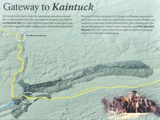
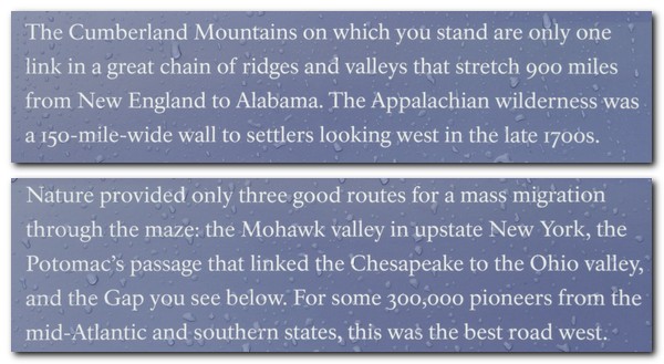
Imagine the topography, especially in the Appalachians, across which huge armies marched and fought each other. Imagine the effort needed to transport tens of thousands of men and their equipment and supplies over almost impenetrable terrain, along river valleys, crossing ridges, swamps, and huge rivers, while constantly being harassed by and engaging with the enemy.
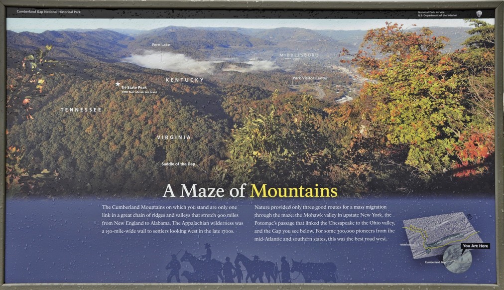
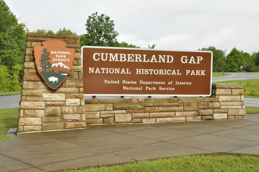
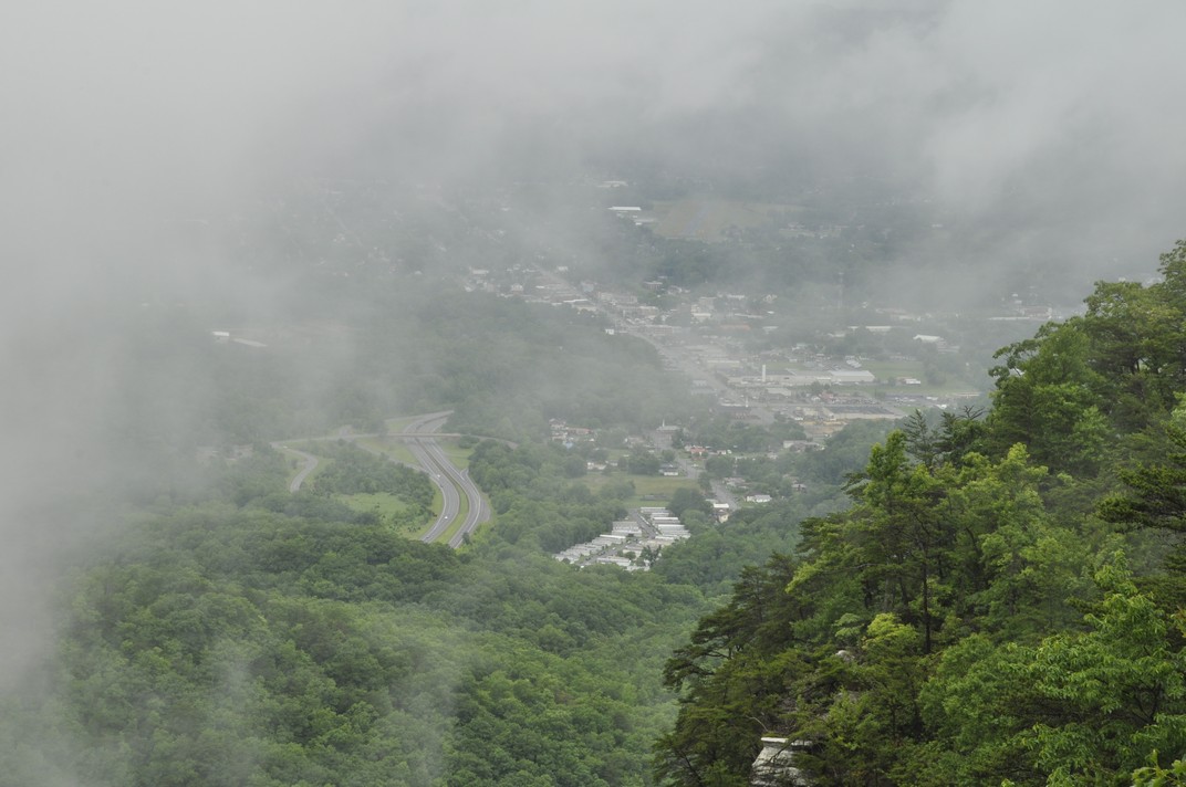
We saw much of this landscape along our 2017 road trip. At Cumberland Gap there were even reminders how the opposing armies had fought to gain the upper hand and strategic overlook that was afforded on the hills surrounding this important pass through the mountains.
In that Sherman biography, I also learned that his superior, Major-General (then Brigadier General) Ulysses S Grant² (yet another Buckeye from Point Pleasant [map], just across the Ohio River from where we traveled this year) had his headquarters at Cairo (map) at the southern tip of Illinois in 1861, just a couple of miles north of Fort Defiance on the promontory at the confluence of the Mississippi and Ohio Rivers. Fort Defiance was on our route west in 2017.
Southwest from Canton, OH we passed by close to Dover (map), birthplace of one the Civil War’s most notorious Confederate raiders or bushwhackers, William Clarke Quantrill³. His theater of operations was the Kansas-Missouri border, an area that was already experiencing conflict between abolitionists and those who wanted to keep slavery in Missouri as early as 1858. Quantrill’s Raiders were the perpetrators of one of the Civil War’s most outrageous atrocity, the Lawrence (Kansas) massacre. Sherman’s brother-in-law, Thomas Ewing, Jr was a key Union general opposing Quantrill.
So while I may have missed out on some interesting historical aspects during this year’s road trip, that was not the case in 2011 when we toured extensively in Arizona and New Mexico. Earlier that year I had read an interesting biography of mountain man and Indian fighter Kit Carson whose campaigns against the Navajo are well documented. I planned parts of the trip around locations where he had been active. He is buried in Taos, NM, and after spending time at the Canyon de Chelly (site of a massacre of Navajos) in northeast Arizona, we headed for Taos.
Spider Rock in the Canyon de Chelly.
History is undoubtedly one of my principal hobbies, and occupies much of my reading. On retirement eight years ago I almost enrolled for a history degree with the Open University, but eventually decided to keep it just as a hobby. I read very little fiction, and the catalyst for my 2017 challenge – to read all of the novels by Charles Dickens – was a book (also bought at Half Price Books) about the terrible plight of children (early in the 19th century) in factories and cotton mills in the north of England.
Here in the UK, Steph and I are very active members of the National Trust and English Heritage. Whenever we get the opportunity, we head off to one of their many properties (stately homes, castles, archaeological sites, gardens) open to the public. And we learn a little more each time about the history of this country and the people who shaped events over the centuries, for better or worse.
~~~~~~~~~~~~~~~~~~~~~~~~~~~~~~~~~~~~~~~~~~~~~
¹ Robert L O’Connell (2014). Fierce Patriot – The Tangled Lives of William Tecumseh Sherman. Random House. ISBN 978-0-8129-8212-1.
² I picked up this biography of Grant which I have yet to start: HW Brands (2012). Ulysses Grant in War and Peace. Anchor Books. ISBN 978-0-307-47515-2.
³ I started this book about Quantrill’s Raiders first. Jesse and Frank James were members of Quantrill’s guerilla band. Edward E Leslie (1998). The Devil Knows How to Ride – the True Story of William Clarke Quantrill and His Confederate Raiders. Da Capo Press. ISBN 0-306-80865-X.
Since 2011, my wife and I have made several long-distance road trips across the USA. And although I’d driven some short distances around Seattle and the Twin Cities of Minnesota, I’d never done any serious driving until then. So, it’s not uncommon for someone to ask whether I find driving in the USA difficult.
Answer: not really. Most don’t know that I spent over 27 years driving on the ‘wrong’ side, i.e. the right, while living in Peru, Costa Rica, and the Philippines.
So driving on the ‘wrong’ side is as normal for me as driving in the UK, on the ‘right’ side on the left. It’s just a case of learning the dos and don’ts, and the manners of the road.
Driving in the USA is (mostly) a pleasure (and straightforward), since away from the cities and main highways, the roads are generally quite quiet. However, some of the Interstates can be quite daunting, especially when two or more come together or diverge like large bowls of spaghetti, often with three or more lanes. Choosing which lane to occupy and when is a challenge. My sat nav during our latest trip was a godsend.
Finding your way around however is not too difficult. The road numbering system is quite clear, but the same road can have more than one name if two highways merge for a section. The Interstates (like the motorways in the UK or autobahns in Germany for example) connect centers of population across the country and are a legacy of President Dwight D Eisenhower, from the 1950s. Then there are the US highways, state roads, and county roads. Each has its own road symbol.
US highways are often divided highways, or dual carriageways as we say in the UK. The one big difference between the Interstates and US highways however, are junctions on the latter (often controlled by traffic lights) where you might have to stop. Most state and county roads are single lane carriageways in each direction.
Compared to the UK, speed limits are generally lower in the US. The norm for Interstates is 70 mph (I’ve seen 75) with a minimum of 40 mph. The maximum speed on US highways is 60 mph (occasionally 65), but most often 55 mph widely applied across the country. In towns the limit is often as low as 25 mph, and special lower restrictions (15 mph) often apply near schools when in session.
Speed limits and driving restrictions around school and school buses are rigorously enforced. When a school bus stops, lights flashing and the Stop sign extended from the rear offside of the bus, you’d better stop or else, whether you’re behind or approaching the bus. I must admit that I didn’t initially realize that the rule applied to oncoming traffic. I remember when we were traveling on US101 in northern California that I passed a stationary bus. Luckily there was no speed cop waiting to ‘ambush’ me.
Roads are more congested with trucks (lorries) in the UK than in the USA, but trucks are behemoths in the USA in comparison, and consistently travel at much higher speeds, often well over 70 mph on the Interstates.
This was one ‘extra’ size load that we saw in Wisconsin.
The idea of overtaking on both sides is something I still cannot reconcile. But it’s common in the USA on roads with more than two lanes. Just maneuvering between lanes can be a nightmare, having to check fast-approaching vehicles on both sides. Also, drivers tend to join a highway high speed; they ‘take no prisoners’, and just keep coming on despite other traffic approaching and occupying the lane they will join.
I often find US drivers reluctant to overtake on single carriageway roads. Admittedly there are oftentimes fewer opportunities to overtake. As I mentioned, we like to take the byways when making one of our road trips, mostly on single carriageway highways, and I try to keep more or less to the speed limit. So I find it aggravating when a ‘local’ starts to tailgate me, ‘encouraging’ me to go faster. But when the opportunity to overtake presents itself, they just remain tucked in behind. Clearly they want to go faster but are not prepared to exceed the speed limit to overtake.
Turning right on a red light takes some getting used to. I now understand that unless it specifically states not to turn, it’s OK to make that turn. Not something we’re used to in the UK. Red means red! And also, having to be aware that if you turn right on a red light, there may be pedestrians crossing as they will have right of way.
‘Right lane must turn right’ (or left) is a common sign on most roads. In fact, it’s useful to have a sort of slip road for departing traffic even on single carriageway highways. But it can be confusing at a junction, when you suddenly find yourself in the right lane and are forced to turn even though you want to go straight ahead. Fortunately my sat nav helped in this respect, and having become accustomed to this situation, I try to position myself in the left lane at a junction to avoid an unwanted manoeuvre.
Roundabouts are common in the UK. Near my home in Bromsgrove there are five within the space of 2 miles. Not so in the USA. Instead there of full stop, all way junctions, governed by a particular road etiquette: the first vehicle arriving at the junction gets to manoeuvre first, but only after coming to a full stop.
When I look over what I have just written, it seems to me that my driving concerns in the USA are not really very important at all. We’ve now covered somewhere in the region of 15,000 miles I guess in our trips. Plenty of time to get accustomed to driving on the wrong side.
However, thinking about the dos and don’ts of driving made me ponder on some other aspects of visiting the USA. And, as it happens, I came across this article, by Sophie-Claire Hoeller (a trilingual journalist who grew up in Germany) in Business Insider: 51 things Americans are doing wrong.
For ease of reading, I also copied her list of ‘things’ into a file.
So, how do these resonate with me? Several on the list are bugbears of mine: (4) Portion sizes; (6) Tipping; (7) Taxes; (12) So. Many. Questions; (16) Checking ID; and (49) Serving a salad first.
I never cease to be amazed by the amount of food that is served in restaurants. Portions are huge compared to the UK. No wonder there’s an obesity problem. I’d rather portions were smaller and bills lower.
Ten per cent is the norm in the UK when tipping – if you think the service warranted a tip. Not so in the USA, where tops as high as 25% are the norm AND expected. I agree with journalist Sophie-Claire. Why should I pay someone else’s wages? In one restaurant recently, where I’d left a 15% tip on the table for our server, I was faced with adding a tip of 25% (no lesser amount) – or none – when using my debit card at the checkout.
Why don’t retailers in the US just include the sales tax in the price listed? How many times have I been caught out at the till, having to add on the tax. Thank goodness for plastic money, and although I used my debit card more this last trip for everyday expenses than I had in previous years, I still ended up with a purse-full of small change. The grandchildren’s piggy banks benefited!
While we were traveling from Massachusetts to Minnesota, we would buy sandwiches, often from Subway, so we could stop anywhere on the route to have our lunch. Then the questions start: wheat or wholemeal, Italian, this meat or that, cheese, mayo, pickles . . . etc., etc. Phew!
I’m almost 70, yet, when buying a couple of cases of beer at Target in St Paul recently, I was asked for my ID! Fortunately the lady at the checkout was from Scandinavia (and had lived in the UK for several years) so recognized my UK photo driving licence. She told me that normally it would have to be a US or Canadian driving licence or passport. Good grief, 70 years old and having to present a passport just to buy a beer! And then there was $2.36 sales tax to add to the offer of $25 for two cases that had attracted my attention.
Salads should be served on the side. Period. I got a strange look from one server when I asked her to bring my salad with the entree. That’s how I like to eat my salad, not as a meal in itself before any other course.
Yes, the UK and USA, two countries separated by a common language (and with Trump in charge, many other things unfortunately), according to George Bernard Shaw. But we enjoy our visits there. It’s a vast – and sometimes quirky – country. Lots more to explore!
Since 2011, we have made five major road trips across the USA, and two of shorter duration.
That first year, we headed for Arizona and New Mexico, taking in the Grand Canyon, Canyon de Chelly and other interesting sites in those dry climates.
We decided to stay closer to home (home being where our daughter Hannah and her family live in St Paul MN) in 2012, just visiting the Boundary Waters Wilderness Region and the Gun Flint Trail of northern Minnesota .
We toured Scotland in May-June 2015 so decided not to make any road trip in the USA, instead choosing to take Amtrak to Chicago for three days.
I broke my leg in January 2016, so any long road trip was out of the question. However, we made a short trip north of the Twin Cities to find the source of the Mississippi River.
The Appalachians called us in 2017, so we flew into Atlanta and drove back to Minnesota through Georgia, South Carolina, North Carolina, Tennessee, Virginia, West Virginia,Kentucky, Illinois, Missouri, and Iowa.
We were equally ambitious this year, taking in New England (Massachusetts, Vermont, New Hampshire, and Maine) before heading west to Niagara Falls in New York, and then south and west through Pennsylvania, Ohio, Kentucky and Indiana, before heading north into Michigan, crossing Lake Michigan on the car ferry, and driving across Wisconsin to end up, once again, in the Twin Cities.
Until this year, I had planned our trips using various maps. For the Arizona/New Mexico and Oregon/California trips in 2011 and 2013, and for trips around Minnesota, I purchased a DeLorme Atlas & Gazetteer for each state. These are very detailed and comprehensive, and show even the most minor of roads. Since we like to take highways and byways (US roads, state highways, and even county roads) as much as possible and avoid the busy Interstates, these DeLorme publications allowed me to draw up quite detailed itineraries.
But they are heavy! And once we planned to drive from Georgia to Minnesota in 2017, carrying around a DeLorme Atlas for each state was not an option.
Instead, I purchased Rand McNally road maps for each state, and plotted a route using Google maps, then transferring it to the map itself, as shown in the image below. I also verified the route using Google Street View, especially to check out the various road junctions.
Steph was the navigator – which had the unfortunate consequence that she had to have her head in a map day in and day out. To assist with navigation I also drew up detailed route instructions on separate cards for each day. One of these is shown in the upper image above. These provided information on the road numbers (roads in the US can carry more than one number as roads combine for short or long distances), junctions, and any other special feature or attraction that we had decided to visit.
However, at Christmas 2017, I received a Garmin DriveSmart™ 51 LMT‑S GPS Navigator with a 5″ display, which came with UK and Ireland maps installed (that are regularly updated).
One of the features I really like is the accompanying BaseCamp software installed on my laptop that allows me to plan routes, with any degree of detail, and transfer them to the sat nav. Once I’d got the hang of its idiosyncrasies, I began plotting routes from home in the UK, finding the best options, and at the same time learning the various features of the sat nav itself.
In BaseCamp I found the easiest way to plot a route was to choose the starting and destination waypoints, and let the software ‘find’ the optimum route. In this example below, I plotted a route from Niagara Falls NY to Canton OH, which was the third day of our recent trip after leaving Maine.
As you can see if you open a larger image, the route calculated would have taken us on the interstate close to the shore of Lake Erie. But I wanted to cut across country and travel through the Allegheny Forest of Pennsylvania.
BaseCamp allows you to shape any route by adding ‘via points’, as many as needed to develop an unambiguous route when it is recalculated by the sat nav itself once transferred.
Then, once all the via points have been added, your final route, below, is transferred to the sat nav.
My Garmin proved invaluable during this trip, especially when we did travel on the Interstates, and these merged with one another, giving me advice when lane changes were necessary, changes to speed limits, and always anticipating any junctions half a mile ahead.
We only had a couple of glitches. Once, after we’d arrived at our hotel, I discovered the reason why the sat nav had asked me to make a U-turn on one street earlier in the day. I’d programmed in the same via point twice. Another time, in deepest Ohio, one of the roads I’d chosen was closed some miles ahead, so we had to follow a set detour. The sat nav didn’t like that, urging me to make a U-turn, or turn at the next junction. Having completed the detour, our original route appeared on the screen, and on we continued. On another occasion, crossing Kentucky along the Ohio River, we had to make another detour, and suddenly the icon for the vehicle was moving across a blank screen – until we reached another road that it recognized. I think we had been diverted on to a new road that wasn’t programmed into the USA maps I’d bought before the trip.
With the installed UK and Ireland maps, I receive updates all the time. The USA (and Canada and Mexico) maps are a one-time purchase, not particularly cheap, but well worth it. It’s just a pity that Garmin does not offer regular updates for these purchased add-on maps as well.
The sat nav is great, but we also found it useful to have a map to refer to see the bigger picture. We were able to find road maps for some states in hotel receptions or at state information centers.
And one of the biggest advantages of using a sat nav? Steph no longer has to navigate hour after hour, and can enjoy looking at the changing landscapes. I wouldn’t say I was particularly stressed on any of my earlier road trips. But with the sat nav I did find that my anticipation level was much lower, and I could also enjoy seeing the countryside we were passing through, knowing that I would be navigated safely to our destinations, especially through built-up areas.
Leaving Niagara Falls via the Niagara Scenic Parkway on the Sunday morning, we headed south, skirting Buffalo and the eastern shore of Lake Erie towards Pennsylvania, and the Allegheny National Forest. Our destination was Canton in Ohio, just south of Akron, a journey of 313 miles.
Along the Niagara Scenic Byway, there are two impressive bridges across the Niagara River on I-190.
There was little traffic around Buffalo, fortunately, even though it was a fine morning for Father’s Day. Soon enough we were outside the city limits and heading south into Pennsylvania.
Pennsylvania was a ‘new’ state for us (as were OH and IN), and I particularly wanted to travel through the Allegheny National Forest.
We travel on the interstates as little as possible, taking US highways and county roads in preference. You get to see a lot more of rural America that way. But roads are none too wide with few places to stop. And certainly no easy stops for photography. So on these two days we have little to show, photographic-wise, for our long days on the road.
The next morning we had an early start as we decided to cover the whole route that I’d planned, some 447 miles south through Ohio, crossing the Ohio River into Kentucky, before crossing the river again further west into Indiana to reach our next destination, Bloomington.
The drive through OH took us through some delightful towns and villages, and productive agricultural landscapes. Although we saw road signs to be aware of Amish buggies on the road, we only saw a couple.
Somerset is a small town about 110 miles south of Canton. In the middle of its impressive town square (which had a very English feel to it) there was a statue to a famous son of Somerset, Union General Phil Sheridan.
We also passed by Dover OH, home to infamous Confederate guerilla leader William Clarke Quantrill (I just bought a biography to read), and also Bainbridge, home to the first dental school in the USA, opened in 1825.
Eventually we reached the Ohio River at Aberdeen OH. The Ohio is a very impressive river and as I commented in a post after last year’s road trip, its flow is greater than the Mississippi. No wonder that rivers like the Ohio were used to open up the interior of the country.
This is the bridge that carries US68 into Kentucky. We crossed a little further west on the William H Harsha Bridge, carrying US62.
Aberdeen is also the terminus of Zane’s Trace, the first continuous road through Ohio, from 1798.
Crossing into northern Kentucky, we were less than 50 miles north of where we had driven through the state in 2017. Then it was over the Ohio again, and into southeast Indiana. Our good friend and former IRRI colleague Bill Hardy (a native born Hoosier) told us that we should see the southern part of the state, since the northern half was flat and rather uninteresting, maize upon mile of maize. He was right. The drive into Bloomington was delightful in the early evening sunshine, with Highway 46 weaving through the trees, up and down dale.
After a restful night in Bloomington (yet another Comfort Inn!) we set off the next day for the penultimate sector of our trip that would take us to Ludington on Lake Michigan in the state of that name. This was another long drive, over 400 miles, north to Gary IN, and then wending our way north along the eastern shore of the lake.
Just over the state line into Michigan we stopped to have a quick picnic lunch at a rest area (and Michigan information center) on I-94. We were very impressed with the amount of tourist literature and maps available at the information center; Michigan certainly knows how to sell itself.
Just north of the state line we took a short detour to Warren Dunes State Park. Lake Michigan is like a vast internal sea, and along its shores, certainly the eastern shore, there are huge sand dunes, now covered with mature woodland. The sand is extremely soft, and hard to walk across. Just like being at the seaside, and although the day was overcast, enough brave souls were enjoying beach to the maximum.
This is Tower Hill Dune that rises to more than 230 feet above Lake Michigan.
Warren Dunes State Park, MI
Then it was back on the road again, heading for our last night stop of the trip, at Ludington, before taking the ferry across Lake Michigan the next morning to Manitowoc on the Wisconsin shore.
The ferry, SS Badger, across Lake Michigan is operated by LMC – Lake Michigan Carferry. Badger is the last coal-fired ferry operating in the world.
It is 393 feet long, and has a beam of almost 60 feet. It was built in 1953 in Sturgeon Bay, WI. Its sister ship, Spartan, has been laid up in Ludington for many years. Originally the ferries carried rail cars.
The 60 mile crossing of the lake takes four hours, but you gain 1 hour moving from Eastern Standard Time to Central Time. As it was a Wednesday in mid-June, before the height of the tourist season, the boat was far from busy. The slow, easy-paced crossing was just my opportunity to catch up on some sleep, in readiness for the final push into the Twin Cities from Manitowoc across Wisconsin, some 321 miles.
We were at the dockside a little after 07:30, and they started to board the vehicles shortly afterwards for an on-time departure from Ludington at 09:00. Vehicles are driven on board by company staff. So before we sailed we had a good look around the vessel.
Soon enough we were headed out of Ludington harbor.
Leaving Ludington, MI to cross Lake Michigan to Manitowoc, WI
And before we knew it, Manitowoc was coming into view, and everyone was getting ready to disembark.
I had planned a route across Wisconsin that took us from Manitowoc through Stevens Point on US10. We took I-43 north for a couple of miles or so, then came off to take US10, only to see a sign stating that the road was closed some miles ahead. With that, I changed the settings on my satnav to take the quickest route to St Paul, rejoining I-43 around Green Bay, and west on Highway 29, until we joined I-94 west of Chippewa Falls for the final 75 miles into the Twin Cities. Highway 29 was a nightmare. Although a dual carriageway (a divided highway) it just went on and on, unrelentingly, in a straight line across Wisconsin. However, we did arrive to Hannah and Michael’s almost an hour earlier than anticipated.
Thus ended our 2018 road trip across twelve states: MA, VT, NH, ME, NY, PA, OH, KY, IN, MI, WI, and MN.
In nine days we covered 2741 miles, plus another 477 miles in Maine itself during the six days we stayed at the cabin. We used 133 gallons of gasoline, at a cost of $384 ($2.89/gallon, less than half of what we would have to pay in the UK for the same amount of fuel), at an average consumption of 24.19 mpg.
I’m already planning for 2019; Georgia to Texas through the southern states seems a distinct possibility.
Leaving Waterford, ME for Niagara Falls early on the morning of 15 June, we allowed two days for this sector of our trip, 366 miles on the first day, and 289 on the second.
We headed west to the Kancamagus Highway through the southern part of the White Mountains of New Hampshire, and a slow climb to reach the the pass at 2855 feet. The cloud level was quite low, and at some scenic overlooks there was sometimes very little to see. But luck was on our side, and we did have some spectacular views in all directions, particularly at Pemigewasset Overlook northwards.
There were many road signs warning of the presence of moose along the highway throughout much of the trip in New England. But we saw neither hide nor hair, not even an antler. Roadkill raccoons were two a penny. This road sign (courtesy of Trip Advisor) warns drivers at the start of the Kancamagus Highway.
Once across the mountains, we turned south for about 30 miles on I-93, to join US4 to cross Vermont, a section we had more or less traveled the week before.
About 10 miles south on I-93 we saw a sign for road works ahead, and we could see the traffic slowing. But then I could also see vehicles moving beyond the ‘obstruction’, one at a time. Funny situation, I thought to myself. Anyway, to cut a long story short, agents (maybe 20 or more, plus dogs) of the US Customs & Border Protection were checking all vehicles for occupants. And, having British passports, we were asked to pull over while I retrieved our passports from a suitcase in the back. Once checked, we were waved on our way. By coincidence, I had read earlier that day a story about these ‘border checks’ miles and miles from any international border (with Canada in our case, or in the south with Mexico).
Once in Vermont we passed through a pretty town named Woodstock. No, not that one – that’s in NY. There was an interesting covered bridge, constructed in 1969 to replace an iron one that had been put across the river in 1877. Apparently this wooden construction was cheaper than other options.
Our destination for this night was Herkimer, NY, about 10 miles east of Utica. Crossing from Vermont into New York, we headed north into the Adirondacks Regions and west around Indian Lake, following for the first part, the valley of the Hudson River.
The following day, we headed west from Herkimer towards Ithaca (home of Cornell University). We passed through many delightful villages, among them Sauquoit where Steph spotted a memorial plaque. I regret not stopping, since it commemorated Asa Gray, born 18 November 1810 (same birthday as me), who is considered the preeminent American botanist of the 19th century.
We enjoyed the rolling landscape, dotted with small farms, the chapels in the villages.
St Paul’s Church, Paris Hill, established in 1797. This is the oldest parish in Western New York, from 1838.
At Ithaca, we stopped to have a picnic lunch beside Lake Cayuga, one of the Finger Lakes that characterize this part of upstate New York.
This is also wine country, and the views across Lake Seneca heading north towards Geneva were stunning. Wineries everywhere!
As we had a prior engagement in Niagara Falls NY that evening, I changed our route, joining I-90 west just north of Geneva rather than cutting across country (a much longer route) as I originally intended.
We arrived in Niagara Falls just before 5 pm, and after checking into our hotel close to the city center and the Falls, we decided to stretch our legs by taking the short walk to the American Falls. The light was just right, and although it was quite busy, I’m sure later in the season this site could be heaving with tourists.
So what was this prior engagement? We had arranged to meet my cousin Patsy and her husband David, who had driven down from Ottawa the day before and were staying on the Canadian side. They had never been to Niagara Falls before either. I had met Patsy just once, in the summer of 1972 a few months before I headed off to Peru. Patsy (just 12 then) and her elder sister Karen had come over to the UK with their mother Bridie, one of my Mum’s younger sisters, to meet the Healy side of the family.
We had arranged to meet for dinner at a small Italian restaurant, La Cuccina Di Mamma on Rainbow Boulevard. What a lovely time we had: great company, good food, and heaps of reminiscing! Steph and David were most indulgent towards Patsy and me.
The next day we were up early to take advantage of the good weather, and to view the Horseshoe Falls from Terrapin Point on Goat Island, and the American Falls in the other direction from Luna Island.
Niagara Falls, NY
The best views of the Falls (mist permitting) are from the Canadian side, but we decided not to cross over. Instead, Patsy sent me these two photos of the American and Horseshoe Falls from their side of the border.
And this short (<3 minute video) illustrates the awesome power of the falls, with a flow of 675,000 gallons/second over the Horseshoe Falls, and 75,000 gallons/second over the American Falls (both relating to summer daytime flow).
Around 10 am, we’d explored all that we wanted, and so set off on the next stage of our journey, 760 miles over two days southwest through New York into Pennsylvania, Ohio, a brief stretch through Kentucky along the Ohio River, and on to Bloomington, Indiana.
It has been great to meet up with our elder daughter, Hannah, and her family (Michael, Callum, and Zoë) for a week in a cabin at Waterford in Maine, taking a short break in our road trip. They flew in from St Paul (Minnesota) three days after we landed in the USA, and on the day that we drove over from Burlington in Vermont, crossing the White Mountains in New Hampshire.
And what fun we have all had together. It’s wonderful to see them again. It has been a year since we were last over on this side of the Atlantic.
On Saturday we decided not to stray far from the cabin, just the short distance to Hawk Mountain to take in the breathtaking panoramas south and west of Waterford.
Looking over ME from Hawk Mtn
Sunday was Michael’s 40th birthday so we celebrated by a visit to Attitash Mountain Resort, about 50 miles west of the cabin along US302. This map shows all the excursions we made during the six days we spent in Maine.
I’d been expecting huge crowds, and long queues for the rides. But no! Although school was out in some areas, the resort was quiet, and we could take as many rides up and down the mountain as we liked, and no waiting.
There were two rides that we enjoyed: the Alpine Coaster, and the Alpine slide. Never having experienced either, Steph decided to ride with Hannah on her Coaster ride; I took Zoë. Callum rode with Michael.
I’d seen videos on YouTube of alpine coasters around the USA. The one at Attitash is advertised as the longest. This is what it looks like.
Michael managed to capture me on his cellphone during one of my descents.
The Coaster was quite a bone shaker. More fun for us ‘oldies’ was the mile long and awesome descent on the Alpine Slide. It’s a bit like the Olympic luge. And we could all take our own carts, even Callum and Zoë.
Here’s what it looks like from a rider’s perspective, from a video I found on YouTube.
To begin the ride, it was necessary to take the chairlift up the mountain, about a 10 minute ride, with incredible views over the surrounding mountains.
And when it all got too much, it was nice just to sit back, relax in the sun, and watch the others having the time of their lives.
Being Michael’s special day, we stopped off for dinner at a recommended restaurant, where he enjoyed lobster, and the rest of us something not quite so exotic. The end to a great day.
After all the excitement of the previous day, we decided to take it easy on the Monday. So Hannah and Michael took the children around McWain Pond in a canoe.
Meanwhile, this was a great opportunity for me to enjoy yet another cold beer in the sunshine, and Steph to knock off another couple of chapters of the book she’d brought with her.
On the Tuesday we set off for Mt Washington, at 6228 feet the highest mountain in the northeast of the USA, and where the highest wind speed was recorded in the 1930s.
We passed by Mt Washington near Bretton Woods on the west side of the mountain while traveling across New Hampshire the week before.
It’s a seven mile drive up to the summit, and we enjoyed a 360° panorama at the top. We were lucky. For more than 60% of days, the summit is completely fogged in. While it was windy (40-60 mph), it was just about manageable.
There’s also a cog railway that climbs to the top, bringing even more tourists who don’t relish the drive. While we were at the summit several trains arrived, and I was fortunate to capture this shot of three at the summit.
After the slow descent, and heating of the brakes, we found a nice spot to enjoy a picnic, let the car cool down, and a rest for ourselves.
On the way back to Waterford, we finally came across one of New England’s famous covered bridges – at Jackson, NH! They really are fascinating, and from what I could tell from various plaques and information online, they are really cherished.
One of the many covered bridges of New Hampshire
Wednesday and Thursday were our big excursion to the coast, to Camden on Penobscot Bay for an all-day sail around the bay on Sailing Vessel Owl with Capt Aaron (Lincoln) at the helm, a direct descendant of folks who came to the USA in the 1680s.
Michael used to sail these waters with his mother and stepfather when he was a boy, and was keen for Callum and Zoë to enjoy the same experience. We left the cabin by 06:30, and were ready for boarding the Owl around 09:30.
We set off east into the bay, arriving at the passage between North Haven and Vinalhaven (map) by lunchtime, in time for a short shore excursion on a small island. Until our return it had been warm and sunny, and mostly smooth. But as we set sail for the return to Camden, the wind got up, the waves increased and the temperature fell.
After a long day at sea, about 9 hours, we arrived back in the harbor, and enjoyed a welcome meal of freshly caught haddock. Since the drive from the cabin had taken about 2½ hours, we had already decided to spend the night in Camden, returning mid-morning the next day.
But before we left, we took a stroll around this pretty town and its harbor. In a small park overlooking the harbor there is a statue memorial to soldiers who fell in the American Civil War of the 1860s, referred to interestingly as The Great Rebellion.
There’s considerable wealth in Camden, given the large houses and boats moored in the harbor, owned by some of America’s most illustrious families.
Before heading back to the cabin at Waterford, Steph and I decided to take a look around Rockport, just a couple of miles south of Camden. On the point of a peninsula east of the town, the simple and beautiful Vesper Hill Chapel was built in 1962, and is dedicated to all young people who found God in their lives.
Then it was time to head west so that we would have enough time to pack, and prepare for the long trip even further westwards the next day.
Such was our week in Maine, enjoying time with Hannah and Michael, and the grandchildren. Callum and Zoë took everything in their stride, full of beans, and always ready for the next adventure. They keep us young!
It’s that time of the year, and here we are, on the road again in the USA. Another potentially daunting road trip that will take us from Boston, Massachusetts (MA) to St Paul, Minnesota (MN) via Vermont (VT), New Hampshire (NH), Maine (ME), New York (NY), Pennsylvania (PA), Ohio (OH), Kentucky (KY), Indiana (IN), Michigan (MI), and Wisconsin (WI), including a ferry crossing of Lake Michigan from MI to WI. This year I’m using my new Garmin DriveSmart 51 sat-nav, for which I purchased the USA-Canada maps. It saves Steph having to navigate, state by state, map by map, as in previous years, so she can enjoy looking at the passing scenery.
We are also spending a week near Waterford in western Maine, with our daughter Hannah and family (Michael, Callum, and Zoë) at a cabin on the shore of McWain Pond, one of the many small lakes that dot the landscape.
Anyway, it all started last Wednesday morning, very early, when a taxi picked us up from home at 04:00 to take us to Birmingham Airport (BHX) for our 06:00 KLM flight to Amsterdam Schipol (AMS), connecting with Delta 259 at 11:15 to Boston Logan International Airport (BOS).
Apart from a rather rude Delta ground agent at Schipol, our connection was uneventful, as was boarding (Sky Priority), and I was soon enjoying my first G&T on the 6 hour 55 minute flight, on a comfortable Airbus A330-300. When we landed in BOS there was a delay of more than 20 minutes while the ground crew figured out how to connect the air-bridge to the aircraft. But soon enough, we were checked through immigration on one of the newfangled automated passport control (APC) machines. I still had to pass through regular immigration (and facing another rude official who even queried me about any visits I’d made to the Middle East). Before long, luggage in hand, we were at the car rental center and picking up our SUV from Budget. The Mitsubishi we had been assigned had a flat battery, so Budget upgraded us to a full-size SUV, a Dodge Journey V6—rather larger than we needed, but extremely comfortable nevertheless, if a little heavy on fuel (about 25 mpg). But at USD3 a gallon, that’s not really an issue. It would be in the UK, however, where gasoline is more than twice the price!
We successfully navigated our way out of the airport and through the tunnels under Boston city center on I-90, after finally getting the sat-nav to behave itself. Our Wednesday night stop was in Hadley, in central MA, just over 100 miles west of Boston, and southwest by a handful of miles of Amherst.
Over the next two days we took in northwest MA, the Green Mountains of VT as far north as Burlington, and then over the White Mountains of NH, to arrive at our cabin destination in Waterford, ME.
Heading northwest from Hadley on Thursday, it was slow-going for the first 20 miles or so as we encountered school traffic and people heading to work. But soon we were in open country, on scenic byway 112 and often had the road to ourselves for long stretches (as we have enjoyed in past road trips). After about an hour we joined MA2, the Mohawk Trail, and followed that until North Adams where we turned north and crossed over into VT.
There was a glorious view south from Whitcomb Summit, and some miles further on, just short of North Adams, there is a spectacular view north into southern Vermont, reminding us of the views we saw when exploring the Appalachians in 2017.
Vermont is a beautiful state, with forested hills and mountains as far as the eye can see.
North of Wilmington, VT we stopped at a general store and deli to buy sandwiches and were intrigued with the Mini Cooper parked outside with an interesting registration plate BONKS. There was also a Golden Retriever with a Union Jack collar. We discovered that the proprietor was British, from Guildford in Surrey (near London)!
We spent Thursday night on the east side of Burlington, conveniently located for the next day’s travel northeast into New Hampshire and Maine, beginning around 08:00.
Most of the small communities we passed through have a general store or two, offering a whole range of produce, and many selling fresh sandwiches from a deli counter. We enjoyed a coffee in the sun at Westfield in the far north of the state, just south of the border with Canada.
Crossing into New Hampshire, we headed towards the White Mountains and were not disappointed with the fantastic view of the Presidential Range and the Mt Washington Hotel Resort at Bretton Woods. That’s Mt Washington just left of center, at 6288 ft the highest mountain in the northeast USA.
But Bretton Woods also has special significance for me. Why? Well, I worked for 27 years at two international agricultural centers, CIP and IRRI, sponsored by the CGIAR (Consultative Group on International Agricultural Research). The CGIAR was founded in 1971 under the auspices of the World Bank. In July 1944, an international conference was held at the hotel to plan for a post-war world, following which the World Bank and the International Monetary Fund were created.
Stopping at Conway to pick up a supply of groceries, we finally reached the cabin around 17:00. A long enough day, followed by a couple of cold beers, an early night, but still far short of some of the travel we have yet to make.
A couple of months back, I enjoyed an excellent 672 page biography of Confederate Major General Thomas J ‘Stonewall’ Jackson. Written by SC Gwynne in 2014, Rebel Yell: The Violence, Passion, and Redemption of Stonewall Jacksonis an account of Jackson’s theatre of operations in Virginia (and in those areas that became West Virginia after it broke from Virginia in 1863), which centered on the Shenandoah Valley, a region just north of where Steph and I travelled across the Appalachians in June this year.
Jackson’s death (from pneumonia after he was wounded in the arm by friendly fire) following the Battle of Chancellorsville in Virginia from 30 April to 6 May 1863 is perhaps among the most significant ‘What if’s’ of the American Civil War. Stonewall was undoubtedly one of the Confederacy’s most successful generals, and history is left to ponder what the outcome of the Civil War might have been had he lived longer, and his success rate against Union forces maintained.
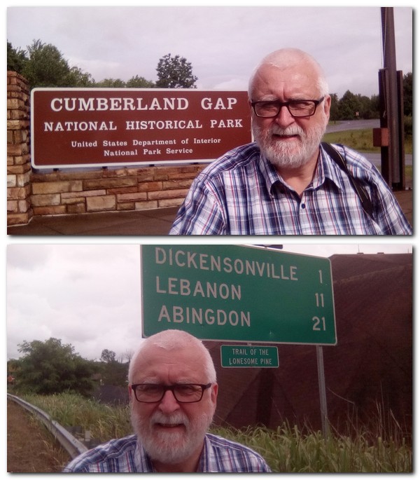
Steph and I saw evidence of the conflict, the to-ing and fro-ing of opposing forces, when we visited the Pinnacle at Cumberland Gap on the borders between Virginia, Kentucky and Tennessee. Successive Union and Confederate forces fought over and continually swapped possession of this key passage through the mountains.
And now I have just finished another book, Noah Andre Trudeau’s 2008 Southern Storm: Sherman’s March to the Sea(at 671 pages) based in large part on the personal accounts of officers and men among the 60,000 who took part in the November-December 1864 campaign in Georgia (the Empire State of the South) led by Union Major General William Tecumseh Sherman, from Atlanta to Savannah, 250 miles to the southeast on the Atlantic coast. They were divided into different columns, and lived off the land as they moved south, through landscapes that hindered their progress as much as did the continual harassment from Confederate forces on their periphery.
Our 2017 USA road trip began in Atlanta, and paralleled, I now discover, the route of Sherman’s March to the Sea although his route took him further east. His occupation of Savannah (where we stayed for a night), and subsequent move up through South Carolina (just as we did) marked the beginning of the end for the Confederacy, as Sherman and his superior, Ulysses S Grant, closed in on Confederate capital Richmond in Virginia, and the final capitulation of Confederate forces under General Robert E Lee at the Appomattox Courthouse in April 1865.
Arriving in Savannah, Union forces found an elegant city of wide, tree-lined boulevards (hanging with Spanish moss) and quiet squares, much as Steph and I did on our trip. Savannah was a delight.
After the end of the Civil War, Sherman’s ‘exploits’ in Georgia were immortalised in Marching Through Georgia, composed by Henry Clay Work.
To me, three aspects of the Civil War stand out. This must have been one of the first wars in which an extensive railway network transported troops and supplies over long distances. In Georgia, Sherman’s troops ripped up hundreds of miles of railway tracks on their March to the Sea. Second, the electric telegraph was an essential (but not always available) system of communication between armies and civilian administrations. Thirdly, the war must also be one of the first to be documented in detail photographically. New York-born Matthew Brady was one of the earliest photographers in the country, renowned for his Civil War output.
Having criss-crossed this region and the southern Appalachians myself, I remain in awe of the feats undertaken by both Union and Confederate armies, tens of thousands of men marching across some of the most difficult terrain, under the most adverse weather conditions, and then having to face each other in battle. The casualties on both sides were catastrophic, the wounds inflicted unimaginable, and rudimentary surgery and medical care often leading to as many deaths after the battles as during them. Conditions in camps were frequently squalid, and diseases were rife. In fact, as many soldiers may have died from disease as on the battlefield.
So what has this whole saga got to do with genetic resources? Let me explain. In an earlier post about crop diversity, I’d commented on soldiers’ accounts of the ‘corn fields’ which they passed, the long-strawed varieties grown, and through which they trampled during the Battle of Waterloo.
In their commentaries during the March to the Sea, Union soldiers were fortunate to live quite well off their foraging activities. In fact, this was part of Sherman’s overall strategy, although backed up with sufficient supplies and beef-on-the-hoof for about five to six weeks, and his calculations based on an understanding of the agricultural economy of the region through which his army would pass.
Soldiers report dining on hogs and chicken, potatoes and sweet potatoes in abundance, peanuts, rice, molasses and honey. I think that, in general, ‘potatoes’ probably refers just to sweet potatoes (Ipomoea batatas) rather than so-called Irish potato, Solanum tuberosum. It interesting to note how important were three crops not native to this southeast region of the country, nor the USA in general: sweet potatoes (from the Asia-Pacific region), peanuts from South America, and rice from Africa and Asia.
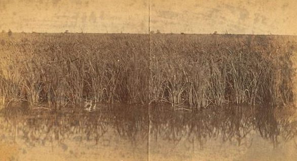
This was, of course, a slave-based economy. Without slave labour, the growing of cotton and rice would have been almost impossible. In antebellum Georgia (as in South Carolina) rice cultivation was very important since the early 18th century. As Sherman’s armies approached Savannah, they encountered rice paddies more frequently. Some had standing crops which they harvested and processed in numerous rice mills once they got them operational again. Other rice paddies, closer to the city, had been flooded (perhaps also with brackish or salt water) and were formidable barriers to infantry. Crossing these wide open landscapes, deep in mud, attacking Union troops were clearly exposed to Confederates entrenched behind carefully-sited defensive lines.
On Monday 19 December 1864, during a manoeuvre on difficult terrain to cross over the Savannah River into South Carolina, one soldier from Massachusetts wrote: We came across rice fields all cut up with ditches from 1 to 10 ft wide, which we had to get over as best we could; part of the way was through rice as high as our heads & all wet with dew. Clearly not a modern HYV! So what could this rice be?
It was probably Carolina Gold, a variety originally thought to have been introduced into South Carolina and Georgia from Madagascar¹. The slaves, many from West Africa, knew all about growing rice, since there is an indigenous rice culture in that part of the continent.
Rice paddy (of Carolina Gold?) near Savannah, GA
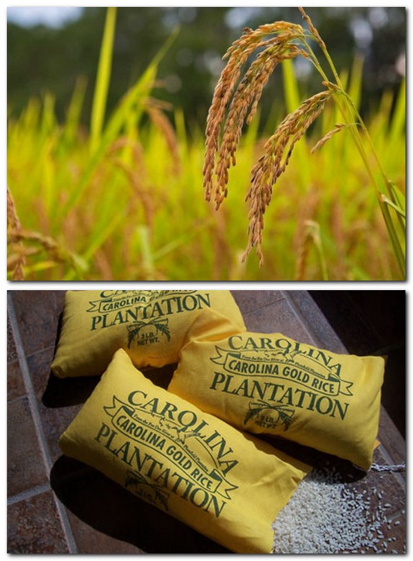
Rice cultivation went into decline after the Civil War, due to many factors including the destruction of paddies, reluctance of emancipated slaves to take on this work, and other global trade pressures. Other parts of the USA became important rice-growing areas, such as California, southern Texas, Louisiana, and Arkansas. By the 1940s Carolina Gold was hardly in cultivation anywhere. Was it lost? Not completely.
In the 1980s, a eye doctor from Savannah by the name of Dr Richard Schulze (and a keen duck hunter) discovered that seeds of Carolina Gold were held in a USDA collection at Beaumont in Texas (the USDA’s rice collection is now held at the Dale Bumpers National Rice Research Center-DBNRRC- in Stuttgart, Arkansas). Scientists at Beaumont multiplied seeds of this accession, sending Schultze some 14 pounds of seeds. By 1988, these had been multiplied to 10,000 pounds. Carolina Gold is now grown quite widely, among other heirloom varieties.
There is even a Carolina Gold Rice Foundation whose mission is to advance the sustainable restoration and preservation of Carolina Gold Rice and other heirloom grains and raise public awareness of the importance of historic ricelands and heirloom agriculture.
In October 2010, my former IRRI colleague, Tom Hargrove (who passed away in January 2011) writing forRice Today about two varieties of rice, Carolina Gold and Carolina White, found along the banks of the Amazon in northeast Peru, conjectured that they were taken there by Confederados, people from the southern US who moved to Brazil around the time of the Civil War. The rice, called Carolino by local farmers, was found by CIAT rice breeder (and an old friend of mine), César Martínez.
When I checked the Genesys database, I found 19 accessions with the name Carolina Gold, in the USDA collection and in the International Rice Genebank Collection at IRRI. Most have available seeds. The accessions at IRRI are duplicates of USDA accessions. Some are breeding materials or selections. I wonder which one was provided to Richard Schulze? In any case, even though they have the same Carolina Gold name, I wonder how genetically distinct they are from one another.
Once again, my interest in the American Civil War (and history more generally) has come together with my other ‘obsession’, the conservation and use of plant genetic resources.
~~~~~~~~~~~~~~~~~~~~~~~~~~~~~~~~~~~~~~~~
¹ Just after I posted this story earlier today, one of my friends from the Crop Trust, Luigi Guarino, Director of Science & Programs at the Crop Trust, told me that he had also posted something about Carolina Gold in the Agricultural Biodiversity Weblog in November 2007. He was commenting on a paper by Anna McLung (Director of the DBNRRC) and a colleague who used molecular markers to assess the affinity of Carolina Gold with other germplasm from Africa. It seems it was more closely aligned with germplasm from Ghana than Madagascar, fitting in better with the slave trade links between West Africa and the early colonies on the east coast of the United States. Hargrove refers to a Madagascar origin for Carolina Gold, and was obviously not aware of the paper by Anna McLung.
And it seems there’s more to be found about Carolina Gold from a whole slew of stories on the Agricultural Biodiversity Weblog.
Steph and I first visited San Francisco in July 1979, en route from Costa Rica (where I was working for the International Potato Center, CIP) to a potato conference in Vancouver, Canada. Then, less than two years later, in March 1981, we were in New York for just a couple of nights. We had passed through JFK in 1975, but not stopped over.
On the west coast
Yes, a potato conference in Vancouver. The 63rd annual meeting of the Potato Association of America where I was to present some of my research on the control of a bacterial disease of potatoes¹. We were taking advantage of CIP’s spouse travel policy for Steph to accompany me, as did our 15 month old daughter, Hannah.
In 1979 there were no direct flights to San Francisco from Costa Rica; that still appears to be the situation today. The most direct routing was via Guatemala City to Los Angeles on Pan Am, and then a ‘local’ connection on to San Francisco. Pan Am used Guatemala City as their Central America regional hub in the 1970s.
As we lived in Turrialba, about 86 km west of San José’s Juan Santamaria Airport, we must have left for the airport in the early hours to catch the morning flight. It was a bit of a hassle in Los Angeles, going through immigration and customs, and transferring terminals. Thankfully, Hannah was mostly a good flier and, as I recall, we had an uneventful journey.
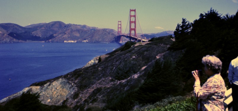
I’d made a hotel reservation in the center of San Francisco, but had wanted to stay at another, the Hotel Beresford on Sutter Street close by Union Square. In those days there was no online booking, of course. So, it wasn’t until we arrived in San Francisco that we discovered the Beresford was just a couple of blocks away, and so transferred the next day. My parents had stayed there when they visited San Francisco on their once-in-a-lifetime post-retirement trip to the USA in 1976.
Mum at the Golden Gate in summer 1976
I think my elder brother Ed had also stayed at the Beresford when he was doing part of his PhD research in the San Francisco area. It came highly recommended, and we certainly felt more comfortable there than our first hotel.
So. You’re in San Francisco for the first time. What do you do, remembering, of course, that anything we planned had to take into account the eating and sleeping needs of a small child? Wandering around the Union Square district we opted for a Gray Line bus tour of the city, taking in a crossing of the Golden Gate Bridge into Marin County among other sights.
Otherwise, we wandered around on foot, or took a taxi to specific places we thought would be interesting. And of course there was the requisite tour of the bay around Alcatraz Island and its former penitentiary, a wander around Fisherman’s Wharf, and dinner on Pier 39.
Steph and Hannah at the Golden Gate Bridge
The Golden Gate Bridge from Marin County side
The Golden Gate Bridge
On the bay boat trip . . .
The entrance to Chinatown
Fisherman’s Wharf
Alcatraz
The Golden Gate
Too soon, our short visit to SF was over and we headed north to Vancouver, the next leg of a journey that would take us also on a road trip from Vancouver to Edmonton, Alberta, a flight to Madison, Wisconsin and a side-trip to the USDA’s potato station in the northeast of Wisconsin at Sturgeon Bay, before returning to Costa Rica via Chicago O’Hare and Miami International.
The Big Apple In March 1981 I resigned from CIP having accepted a lectureship at The University of Birmingham. Although we could have flown directly back to the UK, we planned to travel via New York. We held a bank account with Citibank in New York, and wanted to close that account, withdrawing our savings for transfer to the UK. That meant visiting the bank, completing all the necessary paperwork, then walking out of the bank with a bank draft.
It’s remarkable how smoothly everything went. I’d obviously advised the branch president (manager) of my visit. In those days it was still possible to have personal contact with someone in the bank, and she told me to ask for her when I arrived at the branch. I headed off to the bank first thing in the morning, and was waiting for. She had the forms ready for me to sign, and while she personally transacted the paperwork through the system, gave me several cups of coffee while I waited. After about 45 minutes, I guess, she came back with the cheque, and I went away several thousands of dollars to the better.
That left the rest of the morning and afternoon for sight-seeing, fulfilling two ambitions: a trip to the top of the Empire State Building and a walk round Macy’s. Sight-seeing with Hannah was easier than two years earlier. She was now almost three and seemed to take everything in her stride.
On Park Avenue, looking towards Grand Central Station
The Chrysler Building
Looking north to Central Park
The East Side and East River
Steph and Hannah at the top of the Empire State Building
The East River
Looking south towards the World Trade Center over Lower Manhattan
Statue of Liberty
The World Trade Center
Lowe Manhattan and the towers of the World Trade Center
I’m not sure how we came to choose our hotel, on Park Avenue or close by. Maybe the travel office at CIP in Lima had made the booking for us. The name ‘Loew’s Drake’ comes to mind. But from what I can find through a Google search, that hotel ‘The Drake’ would have been beyond my means. Who knows?
We arrived late to New York on a Lufthansa DC-10 flight from Peru, and went straight to bed. The second night we decided to dine in-house. You can imagine my consternation when I sat down and the maitre d’ placed a jacket on the back of my chair. I hadn’t complied with an implicit (but not obvious) dress code, by not wearing a jacket of my own or a tie.
Deaorting for the UK, we took a British Airways flight from JFK to London Heathrow, occupying a row of three seats (window, middle and aisle), with Hannah in between Steph and me. We must have been about 20 minutes into the flight when I heard a British gentleman in the row in front mutter, rather loudly, to his wife that he hoped the little girl behind wouldn’t bother him throughout the flight. I hadn’t noticed until then that Hannah was sitting with her legs out straight, pushing against the back of this man’s seat. I told her to stop immediately, and she didn’t do it again for the rest of the flight. Anyway, I got out of my seat (I was on the aisle) and moved round to face this man, and explained that I hadn’t noticed what Hannah was up to, it would stop henceforth, and I apologised profusely for the inconvenience. You can imagine how gobsmacked I was when he refused my apology. So I just returned to my seat, somewhat nonplussed. One of the cabin crew had seen this unfold, and as she passed, discreetly encouraged Hannah to continue pushing the seat. We had a good laugh at that.
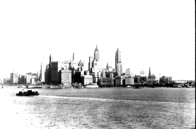
I’ve been back to New York on at least one more occasion since, in the early noughties. It’s a city I’d like to return to and explore more, maybe arriving there on the Queen Mary 2, sailing under the Verrazon-Narrows Bridge, past the Statue of Liberty, and taking in the iconic Manhattan skyline, just as my father did in the 1930s as a ship’s photographer for the Cunard White Star Line. My mother trained as an orthopedic nurse in New Jersey across the river from New York, and watched the Empire State Building being erected in 1930/31. Stories about New York were part of my childhood years.
New York skyline in the early 1930s
~~~~~~~~~~~~~~~~~~~~~~~~~~~~~~~~~~~~~~~~~~~
¹ Jackson, M.T. & L.C. González, 1979. Persistence of Pseudomonas solanacearum in an inceptisol in Costa Rica. Am. Potato J. 56, 467 (abst.). Paper presented at the 63rd Annual meeting of the Potato Association of America, Vancouver, British Columbia, July 22-27, 1979.
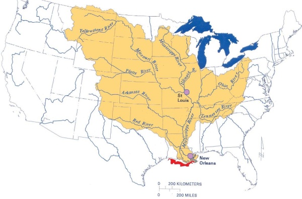
It’s not even the longest river, as such, in North America. From its source at Lake Itasca in northern Minnesota (that we visited in 2016) until the Gulf of Mexico, the Mississippi is 2320 miles long.
The Missouri, on the other hand, which joins the Mississippi near St Louis, MO, flows eastwards for 2341 miles from its source high in the Rockies of western Montana before it reaches that confluence.
One of the other main tributaries of the Mississippi is the Ohio River, at a mere 981 miles, yet its flow is much greater than the Mississippi, and at its deepest point, near Louisville, KY, it is over 130 feet deep. That’s some river! The Mississippi and its tributaries drain almost half the land mass of the the United States.
The Ohio joins the Mississippi at the southernmost point of Illinois, Fort Defiance, just south of Cairo, an almost abandoned town that looks like it has suffered one flooding event too many over the years.
Cairo was, apparently, the prototype for Charles Dickens’ ‘City of Eden’ in his novel Martin Chuzzlewit (which I read recently as part of my 2017 Charles Dickens challenge) published serially between 1842 and 1844. Dickens visited the USA in 1842. He was not impressed with Cairo; neither were we.
We left Cave City, KY just before noon on the Wednesday (Day 8 of our road trip), heading to Troy, IL, and then to follow the Mississippi north through Missouri, Iowa, and southern Minnesota to St Paul. This is our route from Cave City to Iowa City.
Before reaching Fort Defiance, we had already crossed the Tennessee River, which joins the Ohio River near Paducah, KY. Just before Paducah, we turned west and reached the banks of the Mississippi at Wickliffe, just down river from the confluence.
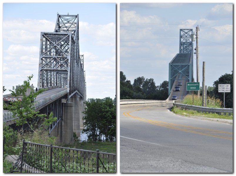
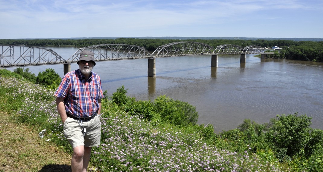
There are two impressive bridges crossing the Ohio and Mississippi. Seeing the enormity of these constructions makes you really wonder at how much an obstacle these rivers were during the westward expansion of the settlers in the 18th and 19th centuries. Today the Mississippi alone boasts more than 130 bridges along its length.
The Cairo Ohio River bridge on the left (5863 feet) and the Cairo Mississippi River Bridge on the right (5175 feet)
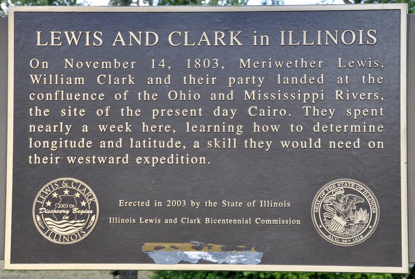
Explorers Meriwether Lewis and William Clark camped here in 1803, and it was a strategic location during the Civil War, for obvious reasons commanding the approaches upriver to both the Ohio and Mississippi.
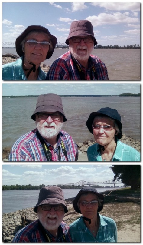
River selfies! We are standing at the tip of Fort Defiance, the southernmost tip of Illinois. Top: the Ohio River, with Kentucky on the far bank. Middle: the confluence of the the Ohio and Mississippi, looking south, with Kentucky on the left bank, and Missouri on the right. Bottom: the Mississippi River, with Missouri on the far bank over the Cairo Mississippi Road Bridge.
Leaving Fort Defiance, we headed north along the Mississippi, on IL3 until Red Bud, when we headed north and skirted around St Louis to the northeast to reach our next stop at Troy, IL.
The following day, the penultimate one of the trip, took us from Troy all the way north to Iowa City, mostly along the banks of the Mississippi. I can’t deny I faced the 43 miles from our hotel on I-270/70 around the north of St Louis with some trepidation. Although it wasn’t quite as busy as I had feared, there was some careful navigation and changing lanes constantly to ensure we headed out in the right direction. Eventually we reached our exit and headed north on MO79, having crossed the Mississippi to cross into Missouri, and then the Missouri River.
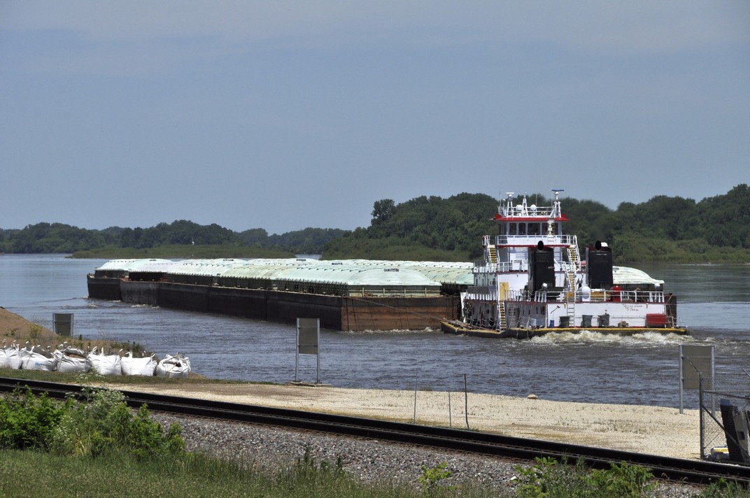
Just over 40 miles north from where we left I-70, the road ran parallel to the Mississippi, and just a few meters away. Having been on the road for a couple of hours, and looking for the inevitable comfort break, we stopped in the small community of Clarksville. There’s a lock and a dam at this point on the Mississippi, and just at that moment a large grain barge (probably empty) was moving through on its way north.
Clarksville has been flooded many times, and some of the riverside properties looked as though they wouldn’t be able to sustain yet another one.
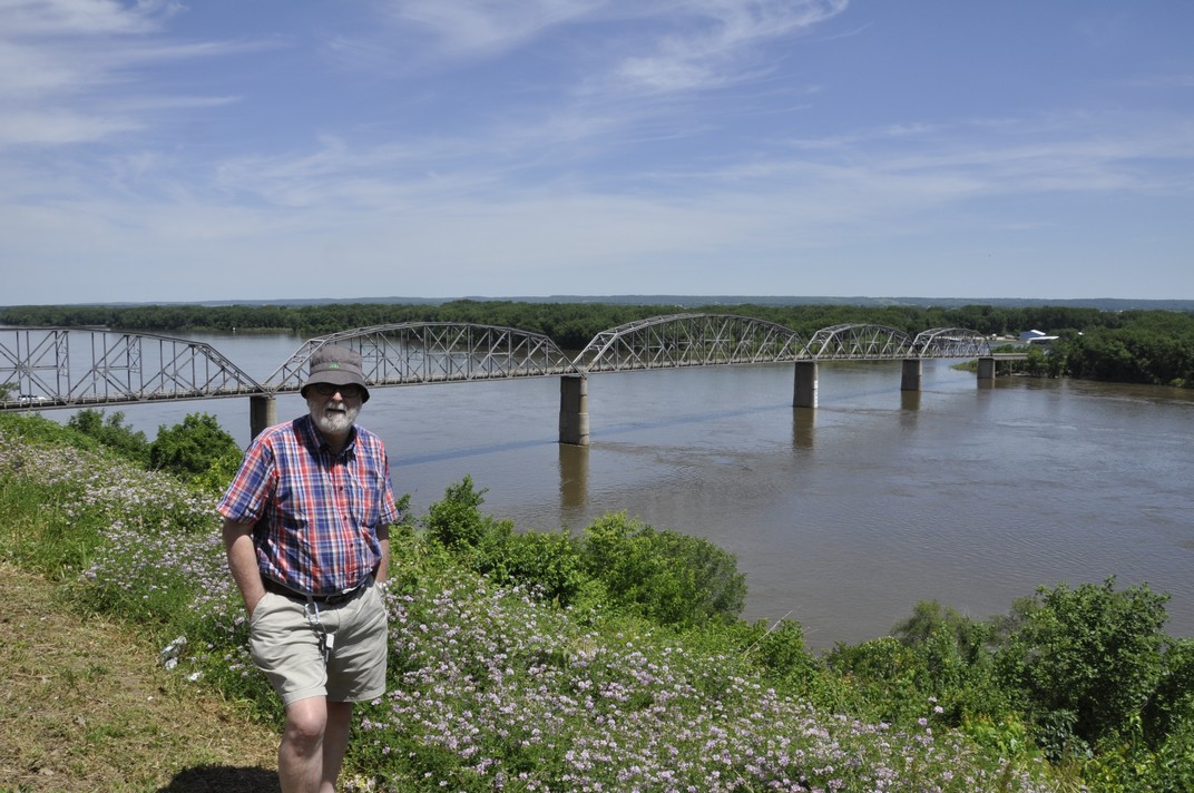
At Louisiana, MO (about 36 miles north of Clarksville) we stopped to view the Champ Clark Bridge from a high vantage point. Built in 1928, this bridge no longer has the capacity for the traffic on US54. By the end of 2019 a new and wider bridge will be in place.
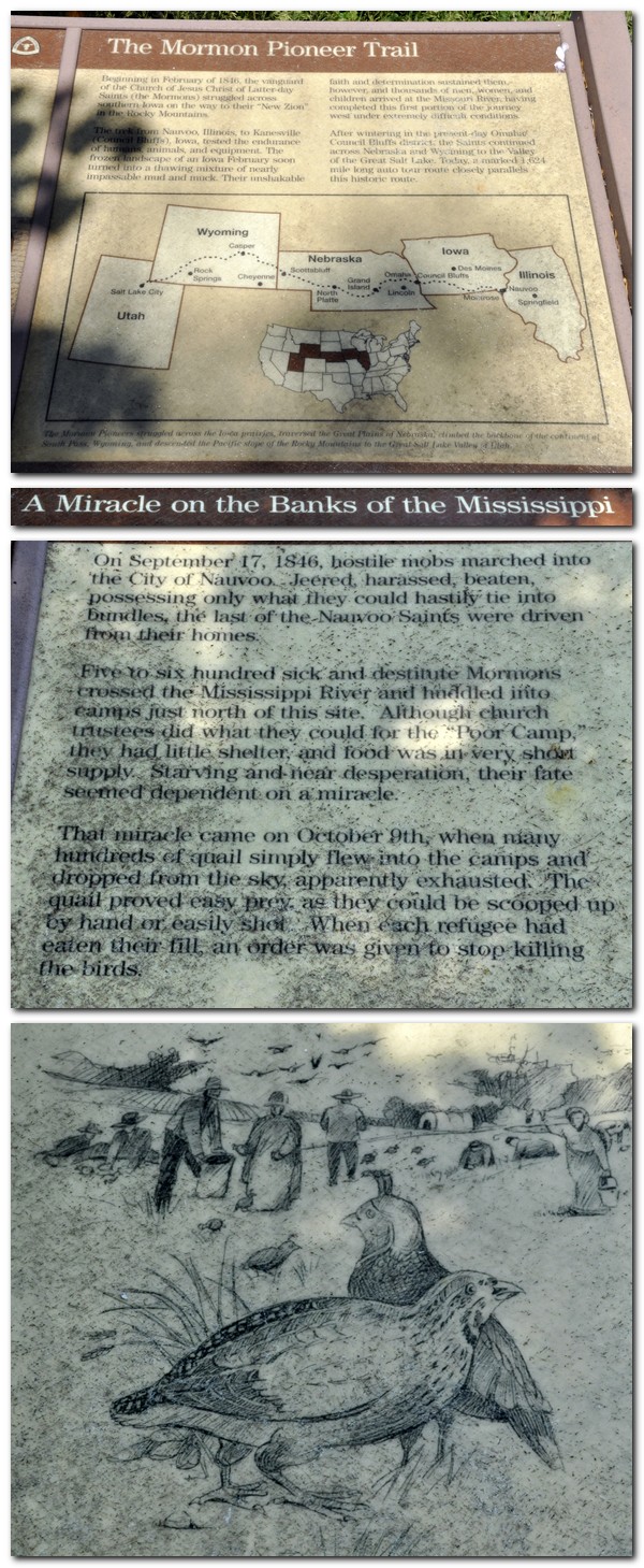
In southern Iowa, north of Montrose, we were reminded once again of the great migration westwards, of pioneers seeking a better life, in this case Mormons heading to Utah. In 1846, Mormons were hounded out of Illinois just across the river, at Nauvoo. The river is well over 1 mile wide here.
A bystander told us that the white building on the opposite bank in Illinois was a Mormon temple, now abandoned.
We turned inland at Muscatine, IA to spend our last night at Coralville, a suburb of Iowa City.
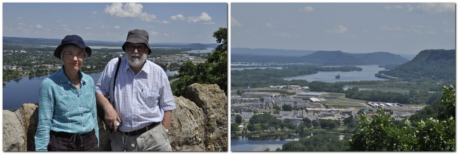
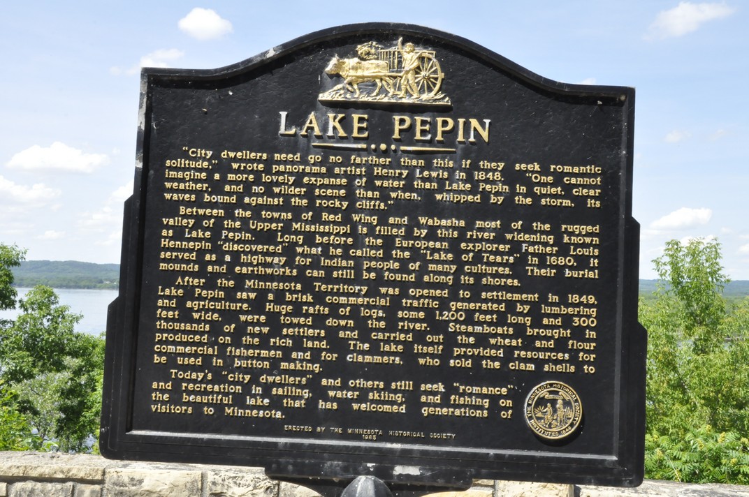
The following morning, we continued our route north across Iowa: flat, rather boring landscape, and mile upon mile of maize. Once we crossed into Minnesota, we turned northeast to Winona and the Mississippi once again. To the west of the town, there is access to Garvin Heights Lookout, some 500 feet above the river. What a view, north and south!
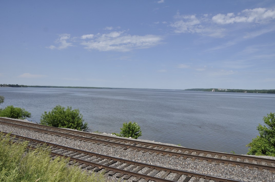
In this stretch of the river, it forms a series of wide lakes. North of Winona, we stopped briefly to view Lake Pepin.
Then it was time to push on, and complete the final 63 miles of our epic road trip via Red Wing and Hastings, MN. Leaving the Mississippi at Hastings and pushing westwards to wards St Paul, we finally arrived at the home of our elder daughter Hannah and her family alongside the Mississippi in the Highland area. The final three days were certainly a Mississippi adventure, although I never aspired to be a latter-day Huckleberry Finn.
The video below covers the final three days of our trip from Fort Defiance to the Twin Cities.
Everyone, every company and organization needs, it seems, a brand. A logo that identifies the brand, and a pithy slogan that suggests orientation, ethos, qualities, aspirations.
Take the International Rice Research Institute (IRRI) for example, where I worked for almost 19 years. It has a distinctive institution logo, in a defined font and font color, and a branding logo and slogan, that succinctly describes the objectives and mission of the institute: Rice Science for a Better World. I was a member (Chair perhaps, I don’t remember) of the committee that came up with this slogan, and my former colleagues in the Communication and Publications Service (CPS) under Ohioan Gene Hettel, then developed the clever logo below.
In the automobile industry, take Ford for example: Go Further . . .
or Nestlé as an example from the confectionery and food industry.
Branding is a real industry, and there’s a lot of ‘science’ behind adopting and deploying the right brand. Even cities get involved.
US states are not immune. As we travelled around the eleven states on our journey from Georgia to Minnesota in June this year, I took photographs of all the state signs at the state lines (except Kentucky – I had to find its brand logo elsewhere). Each of the eleven (with the exception of North Carolina, Missouri, and Minnesota) had a brief slogan to describe itself, such as Virginia is for Lovers, or Wild and Wonderful (West Virginia).
The one that caught my eye, however, and is (as far as I know) quite famous world-wide, is the Kentucky brand.
What an inspiration! Encapsulating, one would think, two of the things that Kentucky is most famous for: the breeding and racing of thoroughbred horses (viz. the Kentucky Derby) and the distillation of fine bourbon whisky.
But these were not, apparently, the ideas behind the brand. Kentucky Unbridled Spirit means that the state is a place where spirits are free to soar and big dreams can be fulfilled. We relish competition and cherish our champions for their willingness to push beyond conventional boundaries to reach new heights of success.
Kentucky has obviously thought in depth about branding. As it states on its website, and citing a Tufts University study, A brand’s purpose is twofold: One – it serves as a major tool to create product differentiation: and Two – it represents a promise of value. From a consumer’s viewpoint, a brand is – above all – a shortcut to a purchasing decision.
Read more about Kentucky’s branding decisions here. I still see racehorses and whisky, and that not so bad really.
Our journey through the Appalachian Mountains (the main focus of our 2017 road trip in the USA) took almost four days traveling through Georgia, North Carolina, Tennessee, Virginia, West Virginia, and Kentucky.
The Appalachians comprise a large system of mountains and valleys, covering a vast area of the eastern USA, and extending into Canada. We explored just the southern end.
Day 4 began in Greenwood, SC where we had stopped the night after traveling north from Savannah, GA the previous day. Leaving our hotel not long after 8 am, we headed west crossing quite soon back into Georgia and working our way northwest through the Chattahoochee National Forest towards Blairsville, GA.
The winding 35 mile climb on GA60 into the Chattahoochee (map) began at Stonepile Gap. With towering trees either side of the road there were few places to stop or see out over the landscape. One of these however was Chestatee Overlook, where we had a first real view of the rolling—and heavily forested—Appalachians.
We expected to arrive in Blairsville after 5 pm, but we were there by 3:30. Rather than heading straight to our hotel, we decided to make a 50 mile circuit to the north and east of Blairsville, and quite by chance came across the entrance to Brasstown Bald, the highest mountain in Georgia, at 4784 feet.
There is a steep drive up to the car park, and a shuttle bus takes you up the final (and very steep) final mile to the observation platform. We arrived around 4:30, just in time to catch the final shuttle of the day, but allowing only about 15 minutes at the summit before the last shuttle would depart for the car park. Given the steepness of the descent (14%), and concerns that my right leg might suffer, we opted for the return shuttle. The visit was somewhat marred by several bikers (who were old enough to know better) using the climb to the car park (a couple of miles at least on a winding road) to ‘race’ their very noisy chopper motorbikes. Quite unnecessary really.
However, it was a glorious afternoon, and the 360° panorama afforded views into North Carolina and Tennessee to the north, and probably Virginia to the east. Just imagine what it must look like in September and October ablaze in all its Fall colours.
The view from Brasstown Bald, GA
The following day, Sunday, our destination was Johnson City, TN taking in the Cherohala Skyway (map), a 50 mile scenic route stating at Tellico Plains, TN and ending at Robbinsville, NC.
The day started fine and sunny, and we weren’t disappointed in the Cherohala. Then we headed to the Great Smoky Mountains National Park, crossing south to north (map) towards Gatlinburg, TN on US441. Unfortunately, by the time we reached the park (one of the busiest in the whole of the country), the weather had deteriorated and it was raining heavily. The Smoky Mountains really were smoky. On the off-chance that we would be above the clouds, we took the seven mile diversion to Clingmans Dome on the North Carolina-Tennessee border, the highest point in the Smokies, at 6643 feet.
There was not a lot to see, to say the least. But dropping down towards Gatlinburg, the clouds did lift and we saw something of the Smokies after all.
Not long after we headed out, we ran into one of the most intense storms I’ve ever experienced. It was raining so hard I could hardly see in front of the car. We did wonder whether our visit to Cumberland Gap would be a wash out. But the closer we got, the weather started to improve, and the sun was even shining as we arrived at the national park. From the Pinnacle Overlook it was hit and miss, now you see it, now you don’t as the clouds closed in, then cleared. But we did have some wonderful views, nevertheless.
The Cumberland Gap has been a major route through the Appalachians for Native Americans and the Europeans who settled there, and wanted to head west.
Overlooking the Cumberland Gap
Cumberland Gap was a strategic route for both Union and Confederate armies during the American Civil War, and exchanged sides from time to time. There are still earthworks high up on the Pinnacle.
The following morning we set off early from Charleston, west into Kentucky. It was going to be a long day, and a rather complex route on minor roads through the Daniel Boone National Forest. This was gently rolling country, but nevertheless magnificent in terms of the trees lining the highways.
Towards the end of the afternoon, we hit the main highways again, heading further west to Cave City, KY for the night, and the next highlight of the trip: Mammoth Cave National Park.
Savannah, Georgia. Founded in 1733, the oldest city in Georgia. It must be one of the most picturesque cities in the whole of the USA. Sitting just 20 miles or so upstream from the mouth of Savannah River on the Atlantic coast.
A city of squares and cobblestone streets, colonial houses, and Spanish moss dangling ubiquitously from trees surrounding the many colonial squares and lining broad avenues that cross the city.
Savannah. A city overflowing with Colonial, Revolutionary War, and Civil War history. A city full of historical markers, and some historical surprises. And, unfortunately, a city with one of the highest gun crime rates in the whole country.
Savannah was the first port of call on our recent road trip from Georgia to Minnesota. I’ve wanted to visit the city for a long time now. Not sure why that was the case, but it is one of those cities that you just have to visit, at least once.
We were not disappointed. And we had just an afternoon and morning to see the sights.
Having arrived to the USA on the Wednesday evening, and traveled just as far as Macon (about 80 miles southeast of Atlanta on I-75), we set off just after 09:00 on the following morning, after a reasonably comfortable night recovering from the journey over from the UK.
South of Macon, I-16 is mostly tree-lined the whole way to Savannah, and there’s little opportunity to see what the landscape is like, other than it’s rather flat. We easily found our hotel, Planters Inn on Reynolds Square, in the historic center of the city (see map), and I’d arranged for valet parking of our vehicle at a nearby multi storey car park.
Once we had settled into our room—upgraded to a larger one with a balcony—we set out to explore the River Street area just north of Reynolds Square, and find a bite to eat for lunch.
There’s so much to see. Along the Savannah River, River Street is lined by cotton warehouses now converted to commercial premises and apartments. Fortunately we were there at the beginning of the tourist season, but I can imagine that later on in the season, this area must be thronging with tourists. I was particularly taken with the wrought iron balconies that were a signature feature of many of the warehouses along River Street. It’s not hard to imagine what the cotton trade must have been like, and ignominy of slavery.
By Thursday evening we were rather tired, enjoyed dinner at the Cotton Exchange Tavern on River Street, and retired early to bed to catch up on our jet lag.
Next morning, with storms threatening by about 10 am, we decided to set out very early to explore the colonial streets of the city to the south of Reynolds Square, and heading to Forsyth Park. We had breakfast at 6:30, and were out of the hotel by 7:30. Within half an hour the first showers appeared, but lasted for just a few minutes, and it was more or less bright thereafter.
There’s one rather interesting surprise in Reynolds Square: a statue of John Wesley, one of the founders of Methodism, who spent a couple of years in Savannah from 1735.
An old cemetery is now the peaceful Colonial Park that we wandered through, the final resting place of so many of the great and good from Savannah’s past. It’s almost next door to Savannah’s Cathedral of St John the Baptist.
Colonial era houses still line Jones Street, and the history of Savannah during the Civil War of the 1860s is evident everywhere. Confederate President Jefferson Davis stayed there. Savannah was occupied by Union troops under General William Tecumseh Sherman after laying waste to Atlanta.
Forsyth Park (some 30 acres) lies at the southern end of the historic district, with an impressive monument to Confederate soldiers.
We returned to the hotel after about three hours, rather hot and sweaty, and took advantage of the hotel offer to use one of the restrooms on the first floor, to freshen up. Having cooled down, settled our bill, and called for our vehicle from the valet parking, we set off for Greenwood, just under 170 miles to the north in South Carolina, over the Talmadge Memorial Bridge around 11:30.
Yes. That’s right. Eleven states in just ten days.
2764 miles to be precise. Ninety-four gallons of gasoline consumed. Almost 30 mpg at just USD209. That’s not bad considering we rented a Jeep Patriot SUV (with a Connecticut licence plate!).
I’d opted for a car rental through Rentalcars.com and chose Alamo as the best deal. Just USD357 for the actual rental, USD250 for the one way drop-off fee, and USD98 for roadside assistance cover and various taxes.
I had planned our route meticulously, taking in various sites and landscape features I thought would be interesting, and avoiding as much as possible any of the interstate highways. I bought Rand McNally road maps for all states except Virginia and Minnesota (we already had a DeLorme Atlas & Gazetteer for MN). I checked precise US and State Routes using Google maps since the scale of the Rand McNally didn’t always show the road name. I even used Google Streetview to check the various intersections, and before we traveled I already had an image in my mind of the entire route.
I prepared daily detailed route plans on cards, which Steph used to navigate us across country from Atlanta to Minnesota, with each map marked at decision points corresponding to the route card details (you can just make out a series of circles on the map below).
Fortunately, US roads are very well signposted and road signs (e.g. US61 or GA23, for example) are posted every few miles. It was hard to go wrong, but we did on three occasions; nothing major, however. My first mistake was leaving the car rental center at Atlanta Hartsfield-Jackson International Airport. I turned on to I-85N instead of I-85S, but was able to turn around within a mile. On two other occasions we made a turn too early, but realised almost immediately. Not bad really for such a long road trip. Nor did we encounter any road works that held us up, or any road accidents. We almost never saw a police car.
These four map links show the actual route we took over the ten days:
We stayed in ‘chain’ hotels like Best Western, Comfort Inn, Quality Inn and the like, about USD100 or so a night. In Savannah we stayed at The Planters Inn on Reynolds Square, close to the river and other historic attractions, and this was our most expensive at around USD230 including taxes and valet parking. Breakfast (if you can call it that) was provided in each hotel. For lunch, eaten by the roadside or at a scenic viewpoint, we picked up a freshly-made sandwich and with some fruit from the hotel, we had enough to keep us going until a substantial dinner in the evening. Surprisingly, we ate Mexican on three nights and had very good meals. There was even beer! Twice we ate at the nearby Cracker Barrel Old Country Store – reasonable food but no beer. Walking into our second Cracker Barrel in Troy, IL it was déjà vu; the layout of the restaurant and the store was identical to the one we patronised in Johnson City, TN.
Anyway, here is a summary of our epic road trip.
31 May, Atlanta, GA – Macon, GA, 82 miles
Our flight (DL73) from Amsterdam landed on time just after 14:15, and despite arriving at an E pier and having to walk the considerable distance over to the new F International Terminal for immigration and customs, then taking a 15 minute shuttle to the new car rentals center beyond the airport perimeter, we were on the road not long after 16:00. We were headed to Macon on I-75, some 82 miles southeast of Atlanta towards Savannah to spend our first night, and recover—to the extent possible—from our long day of travel from Birmingham (BHX), arriving to our hotel (Best Western on Riverside Drive) just around 18:00
Just arrived at Best Western in Macon
We had the room on the right of the balcony, overlooking Reynolds Square
1 June, Macon – Savannah, GA, 167 miles
Since we had only a relatively short journey to reach Savannah, and because I wanted us to get a good rest before setting off once again, we didn’t leave Macon until after 09:00. Our hotel in Savannah (Planter’s Inn on Reynolds Square) had contacted me that morning by SMS asking what time we expected to arrive and hoping to have a room ready then. Not only was our room ready at just after 11:00, but we’d been upgraded to a balcony room. Once we had settled in, we set off on a leisurely stroll around the historic riverside where the old cotton warehouses have been converted to restaurants and other retail outlets, as well as apartments.
Savannah oozes history (and Spanish moss) – a direct line of historical events from the early 18th century, when it was founded, through Colonial times, and the turmoil of the Revolutionary and Civil Wars.
Savannah, GA
2 June, Savannah – Greenwood, SC, 196 miles We spent the morning in Savannah absorbing the Colonial, Revolutionary and Civil Wars history of this beautiful city. The weather didn’t look promising, with thunderstorms forecast, so we left the hotel by 07:30 and wandered through the various squares, parks and colonial streets for three hours, with just a small shower to bother us. After freshening up at the hotel and checking out, we were on the road again by 11:30, headed for Greenwood in the northwest of South Carolina.
The US17 route out of Savannah crosses the Savannah River over the fine-looking Talmadge Memorial Bridge, completed in 1991, 185 feet above the water.
We passed through a heavy rainstorm for the first 20 miles or so, but the weather brightened, and we stopped for a bite to eat beside the road in glorious sunshine. The road north was almost completely straight passing through small towns with names like Denmark, Sweden and Norway. There wasn’t much evidence of much agriculture, just some maize on this coastal plain with rather sandy soils. Communities seemed quite impoverished (according to the 2010 census it is the 7th poorest state). Nevertheless, the Southern Baptist (and some Presbyterian) churches and chapels stood in stark contrast. I’ve never seen so many places of worship so close together. There must be a lot of wicked souls need saving in South Carolina (and surrounding states) to require so many churches, often within just a few hundred yards of each other (or closer).
We were in Greenwood by 17:00, found our hotel, the Hampton Inn, and enjoyed steak and seafood meals at the Red Lobster outlet beside the hotel.
3 June, Greenwood – Blairsville, GA, 195 miles
Distance-wise this was never going to be one of the longest days, but I had planned our route climbing into the Appalachians through the Chatterhoochee National Forest on US60, a winding road among the trees.
We departed from Greenwood around 08:00 and made our first stop at the SC-GA state line to look over the Savannah River at Calhoun Falls. We had another stop at Cleveland, GA to tour the historic courthouse museum, and arrived in Blairsville by about 15:00.
Not wanting to go straight to our hotel, the Comfort Inn, so early in the day, we opted for a 55 mile round trip taking in some of the hills and forest to the north and east of Blairsville, arriving to Brasstown Bald, the highest point in Georgia at 4500 feet, around 16:30 just in time to take the last shuttle bus to the summit, and down again. I decided not to walk the 1 mile descent from the summit to the car park because the average gradient was more than 14%, and Steph and I were concerned that I might hurt my right leg, which is still giving me some grief 18 months after I broke it.
4 June, Blairsville – Johnson City, TN 282 miles
This was our opportunity of really traveling through the Appalachians. I’d chosen to travel east along the Cherohala Skyway in North Carolina. We had expected some poor weather this day, so set off as early as we could get away in order to enjoy the early morning brightness. The Cherohala offers some spectacular views along the way, and we were not disappointed at all.
Looking south from the Cherohala Skyway over North Carolina
But the further east we went, the more cloudy it became, and by the time we reached US441 to cross the Great Smoky Mountains National Park, it was raining quite hard and we didn’t really see very much at all. We took the side route of about seven miles to Clingman’s Dome, the highest point over 6600 feet. Couldn’t see a thing! But lower down on the north side, the weather improved and we did see something of the Smoky Mountains.
We then dropped down to Gatlinburg in Tennessee. If you’ve ever harbored the desire to visit Gatlinburg – don’t. What a tourist disaster! A narrow highway through the center of the town, tackiest tourist souvenir stores lining both sides, and even though this was early in the tourist season, there were throngs of people about. I’m glad we were only passing through. Then it was on to our hotel on the outskirts of Johnson City.
5 June, Johnson City – Charleston, WV, 380 miles
The focus early in the day was the Cumberland Gap, northwest of Johnson City by about 80 miles or so. Not long after leaving Johnson City, along US11, we passed through one of the heaviest rain storms I’ve ever experienced. I could hardly see in front of the car. But by the time we reached Cumberland Gap, the clouds had lifted somewhat, and the sun appeared.
The ‘Cumberland Gap’ is familiar to me from my skiffle days, as sung by Lonnie Donegan.
We went up to the Pinnacle Overlook, hoping to see the views over Tennessee, Virginia, and Kentucky – even as far as North Carolina on a good day. It was only a case of ‘now you see it, now you don’t’ as the clouds came rolling in, then dispersed. As a major pass through the Appalachians, the Cumberland Gap was strategically important for both the Union and Confederacy during the Civil War of the 1860s, and changed sides every so often. There is still evidence of military occupation high on the Overlook.
Looking north into Kentucky and the town of Middlesboro. The highway has just emerged from the tunnel through the Gap.
Then later in the day, heading east towards Charleston, the capital of West Virginia, we traveled along The Trail of the Lonesome Pine in Virginia. Until I was planning this trip, I wasn’t even aware that the Trail was a real entity, not after I’d heard Laurel and Hardy singing about it.
6 June, Charleston – Cave City, KY, 371 miles
Our destination this day was Cave City in central Kentucky where we planned to visit the Mammoth Cave National Park the following day. Heading west out of Charleston on I-64, we turned south at Morehead in Kentucky (about 110 miles west) to head south through the Daniel Boone National Forest.
We traveled some 125 miles along scenic highways and byways. Then we turned west on the Cumberland Parkway west of Somerset, KY for the rest of the day’s trip to make up some time and so as not to arrive to our hotel too late. However, Kentucky is divided into two time zones, so we gained an hour (from Eastern to Central Time) about 80 miles east of Cave City.
7 June, Cave City – Troy, IL, 367 miles
The Mammoth Cave National Park opened at 08:00, and we were at the Visitor Center not long afterwards. I had booked a tour of the Frozen Niagara cave some months back, at 09:20. This was a guided tour, the first of the day, and to a cave that was easily accessible. I didn’t want to contend with scrambling over rocks with my leg. In any case we planned to stay at the Park only until late morning as we still had the whole day’s trip of over 350 miles to make.
We enjoyed the cave, along with a group of fewer than 30 others. The caves are kept closed and it’s generally not possible to visit them alone. What amazed us is that the cave system, at over 440 mapped miles is the largest system in the world. The Park gets very busy during school holidays, and we were fortunate to have visited when we did.
Our next port of call was Fort Defiance at the confluence of the Ohio and Mississippi Rivers, and the southernmost point of Illinois. Most impressive.
That’s the Ohio River behind us and the bridge between Kentucky and Illinois . . .
At Fort Defiance, at the southernmost tip of Illinois, at the confluence of the Mississippi and Ohio Rivers
Then we followed the Mississippi north towards St Louis and our hotel in Troy just northeast of the city, catching a glimpse of the famous Gateway Arch as we skirted the city center on the Illinois side of the river.
8 June, Troy – Iowa City, IA, 332 miles
Our plan was to follow the Mississippi north through Missouri into Iowa. Heading west around the north of St Louis we crossed both the Mississippi and Missouri Rivers close to their confluence. Heading north on MO79, we stopped at Clarksville to stretch our legs, and look at the dam and lock, where a very large combination of barges was being ferried northwards slowly against the current.
Further north we stopped also at Louisiana, MO to view the Champ Clark Bridge that connects MO and IL, from a vantage point high above the river.
Then it was on to our next, and last, overnight stop in Iowa City.
9 June, Iowa City – St Paul, MN, 333 miles
Our last day on the road, heading north on very straight roads, before crossing into southern Minnesota and crossing the Bluff Country eastwards to reach Winona on the Mississippi.
Just south of the Iowa-Minnesota state line we passed through Cresco, IA which proudly advertises itself as the birthplace of Dr Norman Borlaug, father of the Green Revolution in wheat and Nobel Peace Prize Laureate in 1970, who I had the honour of meeting when I worked at IRRI.
In Winona, we took a short diversion to a scenic overlook about 500 feet above the river valley and had a spectacular view north and south.
Then we set off with added determination to arrive to Hannah and Michael’s in the Highland Park area of St Paul by late afternoon, and the end of our enjoyable 2017 road trip adventure.
Here are the individual blog posts about the various places we visited:
I probably wasted a couple of hours yesterday afternoon watching the inauguration of Donald Trump as the 45th President of the United States. I couldn’t help myself. I just wanted to see how Trump would behave. I wasn’t disappointed. I even posted on Facebook while he was delivering his Inaugural Speech that he sounded like he was still on the campaign trail. It must continue to rankle, being such a narcissus I guess, that he won the election by a landslide loss to Hillary Clinton of almost three million votes.
I bet he had his fingers secretly crossed . . .
How depressing the spectacle was, for many reasons (and it seems that despite whatever spin Trump puts on it, his Inauguration was decidedly low-key) I was left at the end with a profound sense of unease, depressed even. It was the same feeling I had (and continue to have) after the EU referendum last June, and the UK voted (by the smallest of margins for such a social, economic, and constitutional—and irrevocable—change) for Brexit.
Is Barron Trump thinking about all the stick he is going to take when he goes back to school in New York on Monday?
After Trump had taken the oath, the former President and Mrs Obama left Washington, DC on board a helicopter bound for the Joint Base Andrews in Maryland, en route to a well-deserved vacation (and period for reflection) in California. The BBC live broadcast captured an image of the helicopter flying northwest over Washington carrying the former president and his wife away.
And I had this feeling that going with them was their dignity, decency, cordiality, ethical behaviour, and vision. Nature abhors a vacuum. It’s now filled with the mean-spiritedness of the Trump Administration, and the crass ostentation that The Donald personifies.
Welcome to the USA – about to become an extension of Trump, Inc. That’s certainly the impression seeing The Donald surrounded by his family. And the photo of him sitting at his desk in the Oval Office later on in the day, with Vice President Pence beside him (how soon will he fade from the limelight?), and Trump’s son-in-law and now Senior Adviser to the President, Jared Kushner (now there’s a prime case of nepotism).
As for Trump’s tie, I found this apt description: Red is an aggressive color that can make us feel passionate, angry, or hungry. The candidates in red ties want you to think they are decisive, bold, assertive, and powerful. Candidates accused of flip-flopping often roll out the red ties. Sound familiar?
We have a personal connection to the USA. Our elder daughter completed much of her education there, in St Paul, Minnesota, where she met her husband Michael, and where she continues to live and work, with children Callum and Zoë. We have visited the USA many times over the past 25 years,and have travelled extensively. Everywhere we went we have been met with warmth, courtesy and cordiality. I don’t recognise that in Trump’s take on America in his Inaugural Speech. No, I don’t deny that there is deprivation in swathes across many states, sites of former heavy industry that has been lost to competition elsewhere, or been overtaken by technology. These folks feel they have been neglected (just as those who voted to Leave the EU last June here in the UK), and Trump tapped into that sense of isolation.
He’s a multiple bankrupt billionaire businessman who is focused on one thing, and one thing only: himself (and his business opportunities of course). It’s unlikely to be America First! Trump First! Just like his branding franchises, will it soon be TRUMP USA?
What interest will he have in the common man and woman. Indeed one of his first Executive Orders, signed just hours after taking the oath of office, was to begin the process of rolling-back the Affordable Care Act. And that will directly affect the very constituency that expect him to perform miracles for them. And then any reference to climate change was removed from the White House website.
Trump has also surrounded himself with like-minded and very rich sycophants in his cabinet (if they are confirmed). Just like Pence, what influence will they actually have? The Tweet is mightier than the sword!
You know, Trump could found his own church (just like a number of fundamentalist preachers in the USA), and become the High Priest. After all, religion is faith, belief. Not fact. His invocation of God several times towards the end of his speech was, by the way, the depth of hypocrisy.
And as a Brit, it sickens me to see all our Conservative politicians wetting themselves over their future relationships with the Trump Administration. Also, deluding themselves that the UK will be ‘at the front of the queue’ when it comes to relations and trade deals with the USA (on American terms, of course). Trump is about to screw us. After all, Trump declared it would be America First! (after him, of course).
Then there’s the spectacle of UKIP former leader and self-proclaimed non-entity Nigel Farage almost orgasmic now that the bust of Winston S Churchill has been restored to its ‘rightful’ place in the Oval Office.
Don’t get me wrong. The UK needs to develop a solid relationship with whatever administration resides in the White House. But Trump has clearly signalled where his priorities lie. And that should give us all pause to consider what the next fours years hold in store, not only for the USA, but for all of us. A scary thought indeed.
When I was a small boy, more than 60 years ago, I never saw any police officer on the streets carrying any sort of weapon, other than a sturdy truncheon. Regular use of firearms was unheard of in British policing, although I’m sure the police always had access to firearms if needed, provided the appropriate authorisation was given.
Sadly, it’s not uncommon now to see many police officers carrying side-arms, automatic weapons even. The increased threat of terrorist attack means that many public buildings, airports or railway stations are now patrolled by armed officers. And of course many police officers also carry a Taser to incapacitate dangerous suspects.
Of course it’s very different on the other side of the Atlantic. Firearms are regularly used by police and there has been a spate of incidents recently when police in several cities have shot African Americans following, it seems, minimal or no provocation. And, several mass shootings. Access to guns and the US Second Amendment has become a big issue in the presidential campaign. Did Donald Trump actually hint that Second Amendment supporters shoot his rival Hillary Clinton? Unbelievable!
Easy access to guns is something we are not just used to here in the UK. So, imagine my surprise recently during our mini-break in northern Minnesota, and stopped for coffee in the small town of Walker. Steph and I had gone into a coffee shop, and as we enjoyed our beverages, I leafed through several magazines and advertising brochures that were sitting on the table beside me.
Here were a couple of flyers advertising a million dollar gun sale at a local store, Reeds, that happened to be across the street from the coffee shop. Every type of weapon you can imagine was up for sale, and many other bizarre and obnoxious accessories as well. I couldn’t help myself. I just had to take a photo or two on my mobile.
We receive flyers and other advertising as inserts in free newspapers in the town where we live in England. But there are for furniture sales, new savings deals at one of the local supermarket, and the like. No guns!
Now northern Minnesota is hunting and fishing territory. But who needs an automatic rifle or worse for hunting? Who needs to go hunting in the first place, anyway?
So with my spirits rather dampened, we went for a walk up and down the street, and found a shop that specialised in beads and beading accessories – a major hobby of Steph’s. As she looked through all that was on display before choosing a range of beads, I had a look around the premises at all the tourist souvenirs. I couldn’t help taking photos of these two signs, and left the shop with a smile on my face.
Over the years we have got to know our way around St Paul, Minnesota, quite well. Minneapolis (the other half of the Twin Cities) less so. The grid system of tree-lined avenues and streets makes it quite easy to navigate around the city, with a significant number of avenues running west to east from the banks of the Mississippi River to the Cathedral Hill district.
Two avenues, Summit and Shelby, actually converge at Cathedral Hill (map), and from the steps of the magnificent Catholic Cathedral of St Paul, you can enjoy a panoramic view over the downtown area of St Paul, from the Minnesota Capitol (currently being renovated) to the northeast and the Mississippi to the southeast.
Looking east on Selby Ave towards the Cathedral of St Paul.
The downtown St Paul skyline, with the state capitol to the left, and the business district to the right. The Mississippi lies just beyond the business district.
So, a couple of weeks ago, Steph and I decided to drive over there, to take a walk round, and for me to do some photography. It has been six years since we last wandered round there. Our eldest grandchild, Callum, had been born just a month earlier in mid-August 2010, and while Hannah (our elder daughter, his mother) had a hair appointment, we pushed Callum around in his pram. Respite for the new mum, first grand-parenting responsibilities for Steph and me.
16 September past was a bright but overcast day, perfect for photography because there were no harsh shadows to complicate matters.
For the past seven years I have been using a Nikon D5000 DSLR. I bought it in the Philippines a few months before I retired, and I’ve been very happy with it. It had an 18-55 mm lens fitted when I bought the camera, and around 2012 I acquired a 200 mm lens. Now, while I liked that telephoto, it wasn’t very convenient having to constantly change lenses for just ‘that’ shot. Often, I just didn’t bother.
However, a few days before we flew to Minnesota for our latest visit at the beginning of September, I treated myself to an all-in-one lens, Nikon AF-S Nikkor 18-200 mm 1:3.5-5.6 GII ED lens – an early combined birthday and Christmas present. So our Summit-Selby wander was a good opportunity to test some of its capabilities.
I decided that some shots of the cathedral, both wide angle and telephoto from the same location would be quite interesting, and here are some of the results.
The Summit-Shelby neighbourhood is rather lovely, but expensive. Along Summit are some of the grandest houses that I have ever seen; and some more modest ones too. It’s also a neighbourhood famous for the great and good of St Paul who settled there over the past century or more. Authors F Scott Fitzgerald (The Great Gatsby) and Garrison Keillor (A Prairie Home Companion) both lived in the neighbourhood at one time or another.
In fact Keillor once owned a bookshop underneath Nina’s Coffee Cafe on the corner of Selby and Western Ave N, a well-known and popular meeting place in that neighbourhood (he has now moved to another venue on Snelling Ave near Macalester College).
These are just a few of the properties that caught my attention as we walked around.
And on the corner of Summit Ave and Western Ave N, there is a delightful small park, Cochran Park, with an elegant fountain with abronze statue of a running Native American with his dog at his feet.
All-in-all, an excellent morning’s exercise, coffee break, and photography. I look forward to many more opportunities.
During our visit to Minnesota in September 2015, we visited the Minnesota Landscape Arboretum (owned by the University of Minnesota) with Hannah and Michael, and grandchildren Callum and Zoë. Being a year younger than today, we had to get back home so they could have a post-lunch nap. So we really only had time to see the various gardens closest to the Oswald Visitor Center (click here for condensed visitor guide and map)
Steph and I returned to the Arboretum almost a month ago, and this year we took the Three Mile Drive around the site. There is so much to see, and the various plantings are laid out splendidly. The crab apple collection particularly caught my attention.
So rather than try to wax lyrical about the Arboretum, I’ll let you follow the links I’ve made here to the various websites, and let my photos speak for themselves.

 My son-in-law, Michael, is – like me – a beer aficionado, and keeps a well-stocked cellar of many different beers. It’s wonderful to see how the beer culture has blossomed in the USA, no longer just Budweiser or Coors. I had opportunity to enjoy a variety of beers. Those IPAs are so good, if not a little hoppy sometimes. However, my 2018 favorite was a Czech-style pilsener, Dakota Soul from the Summit Brewing Company based in St Paul.


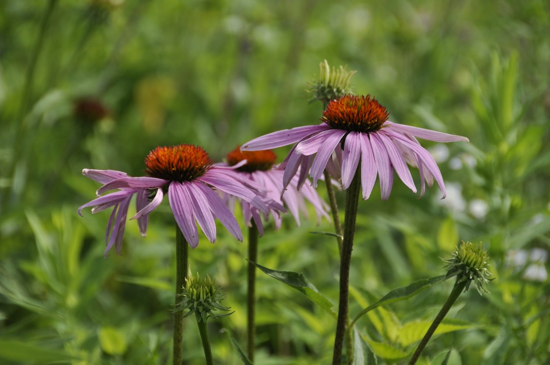


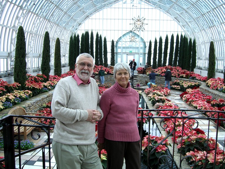
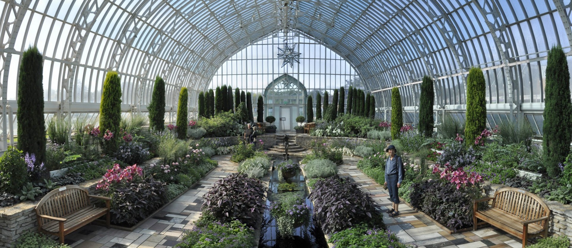
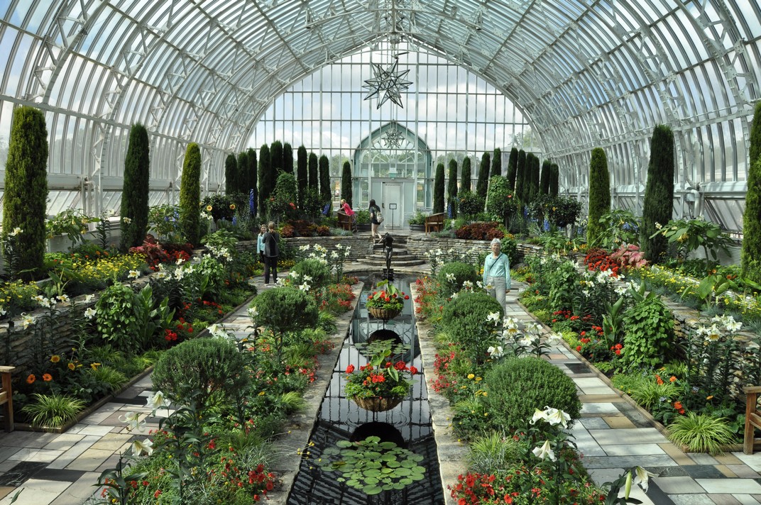
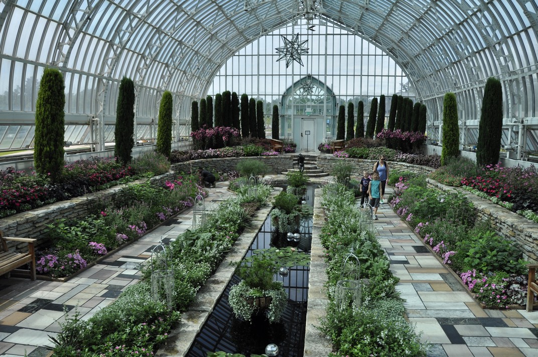

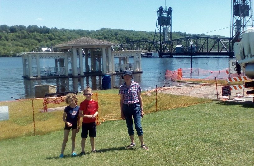
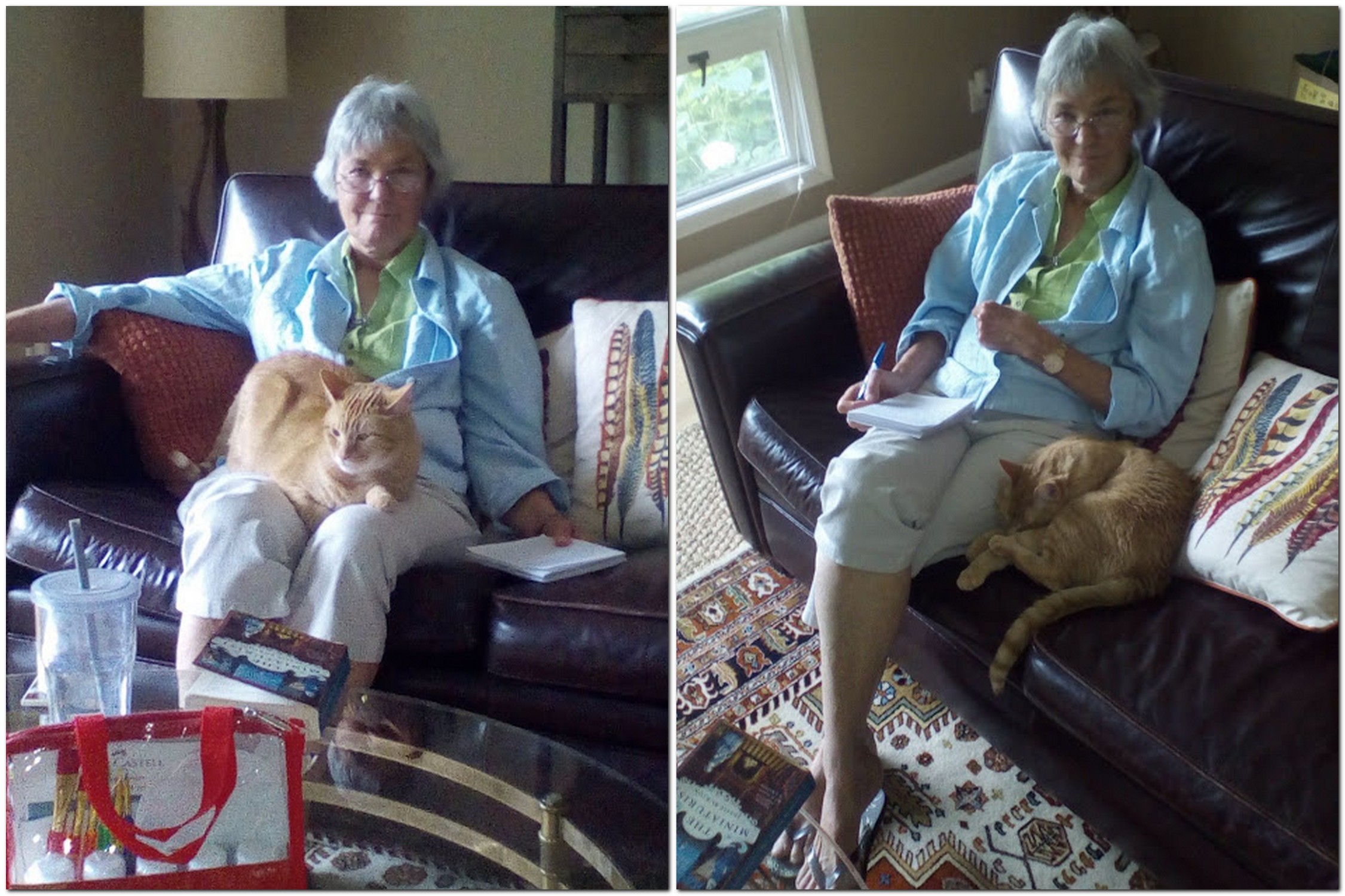
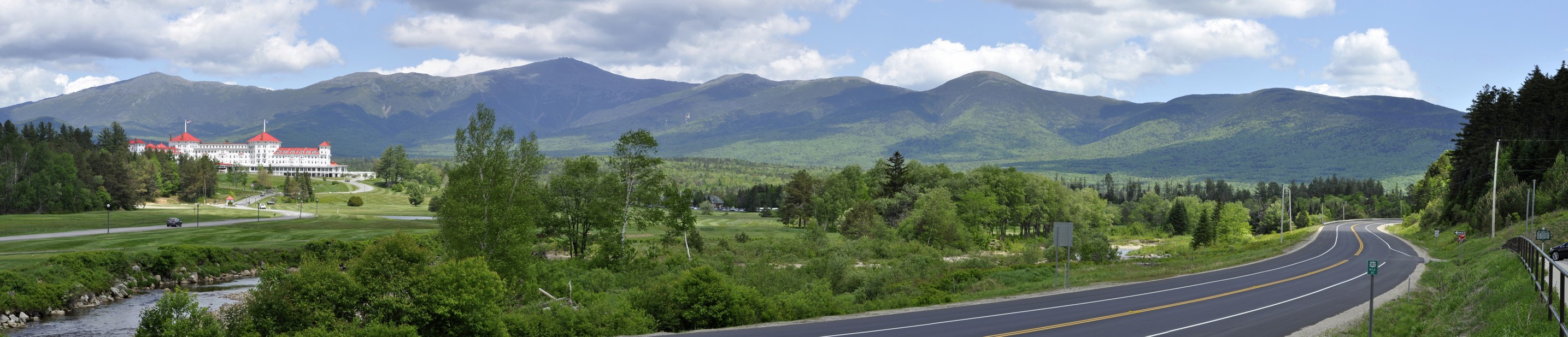
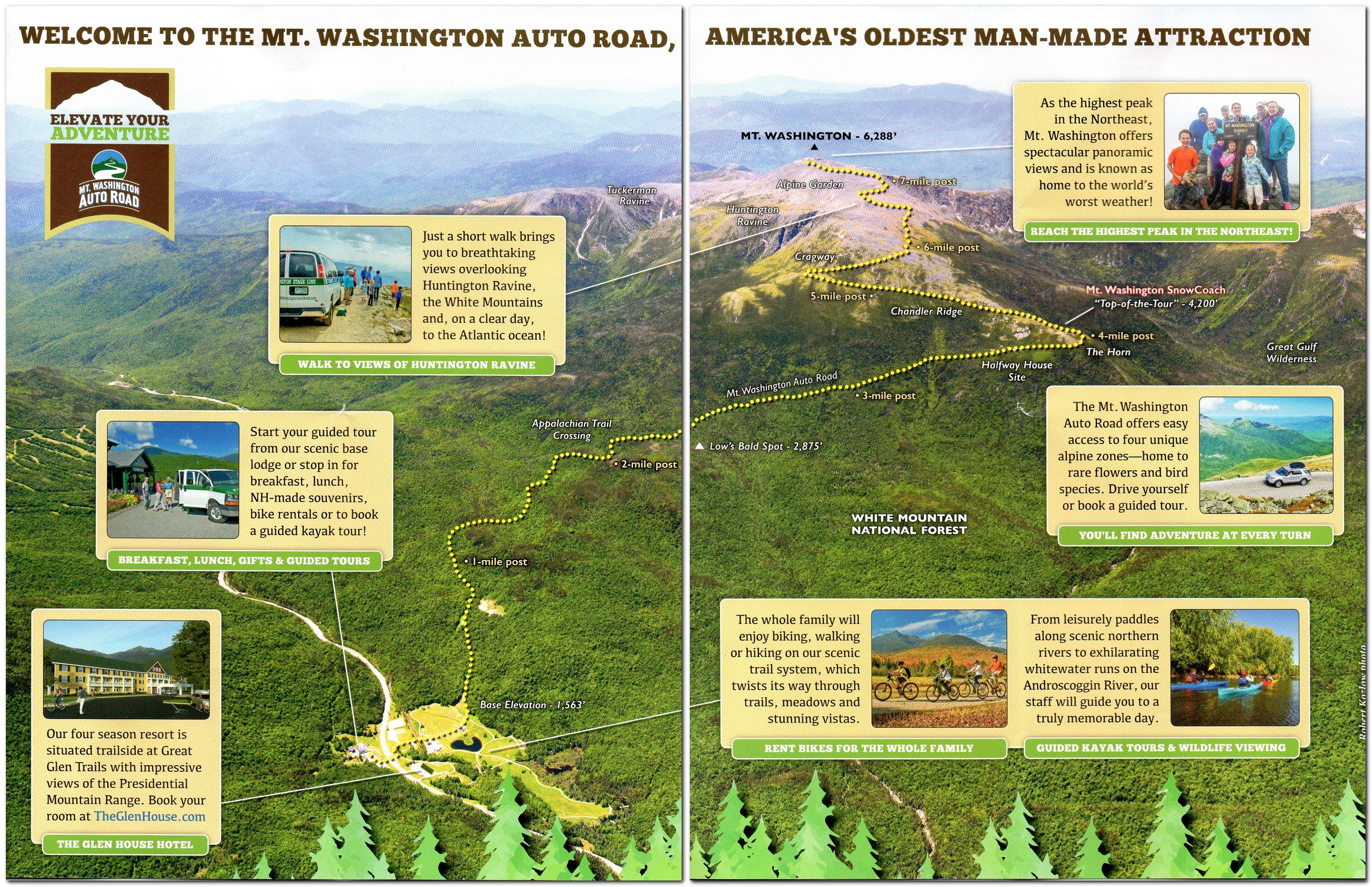
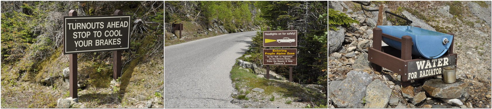


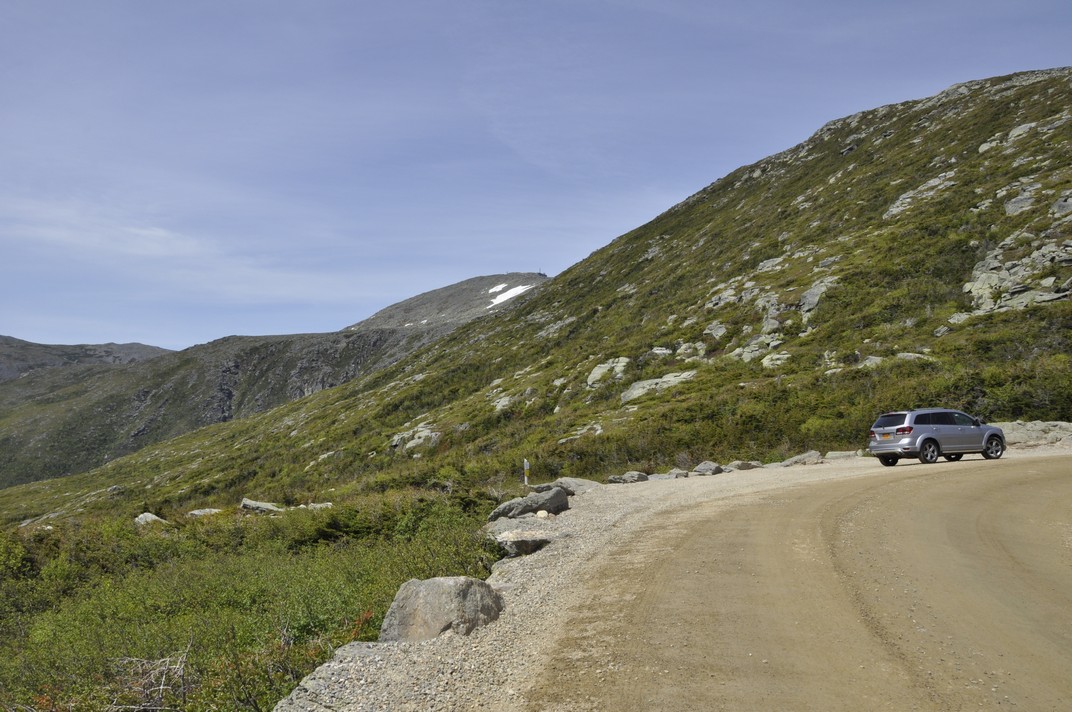
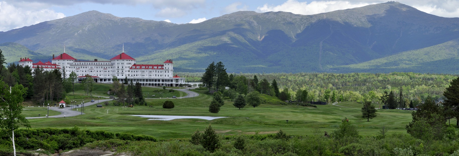


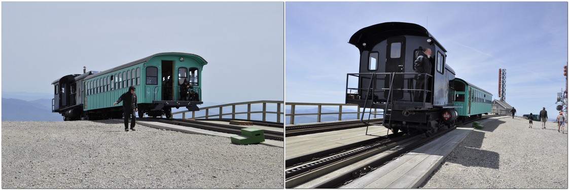
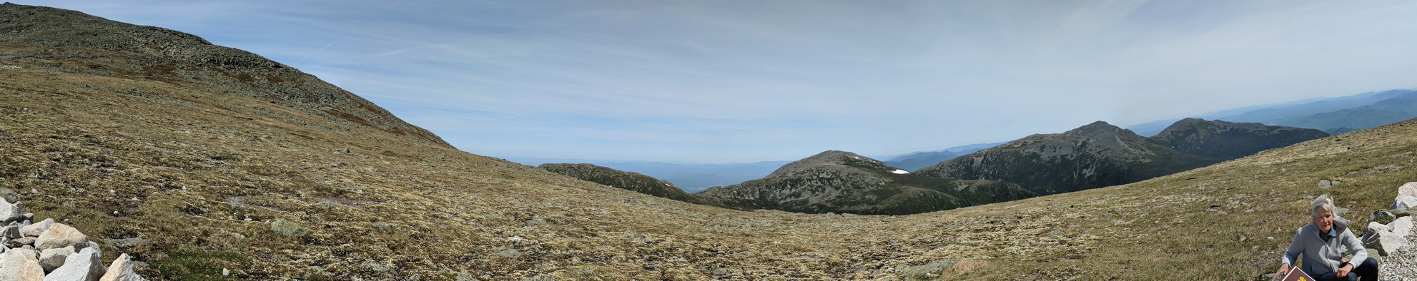

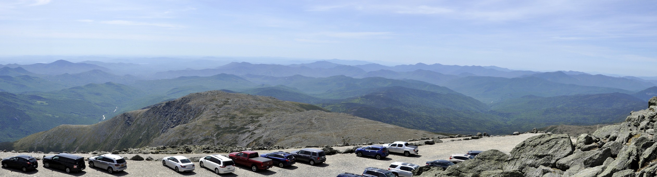

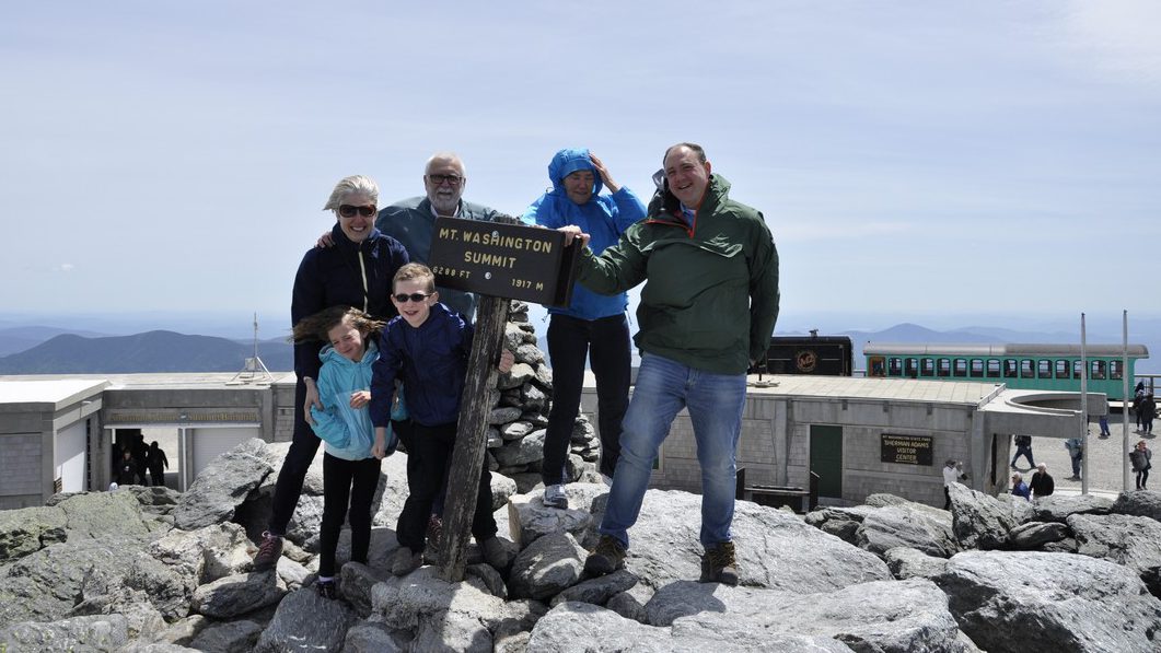
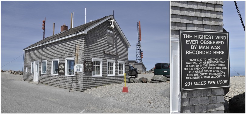
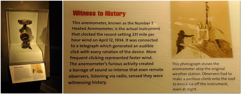


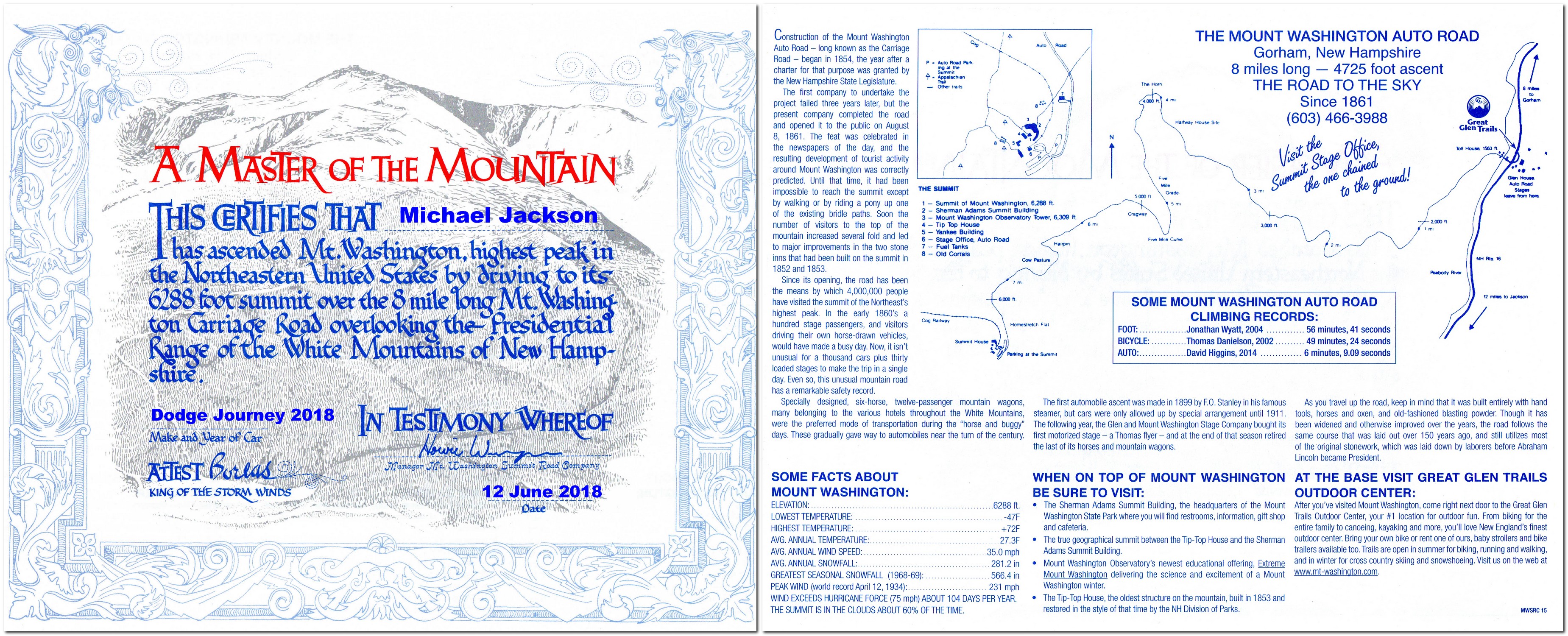

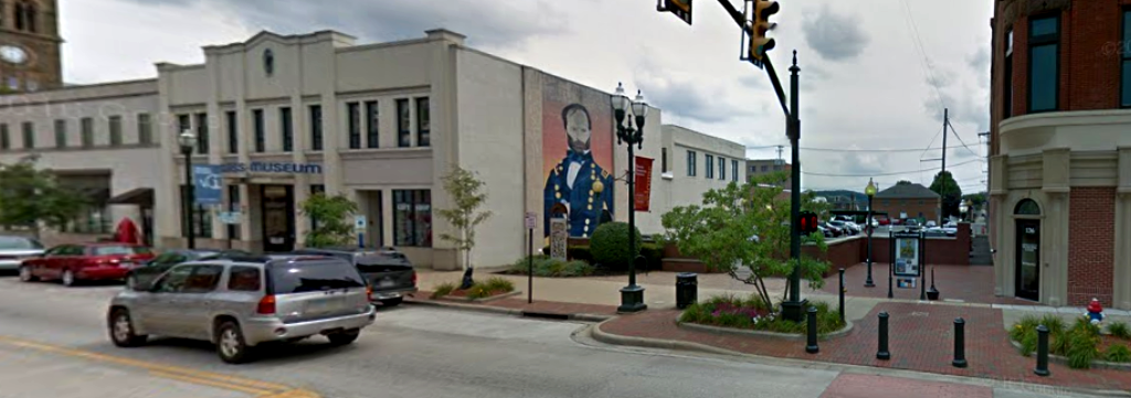
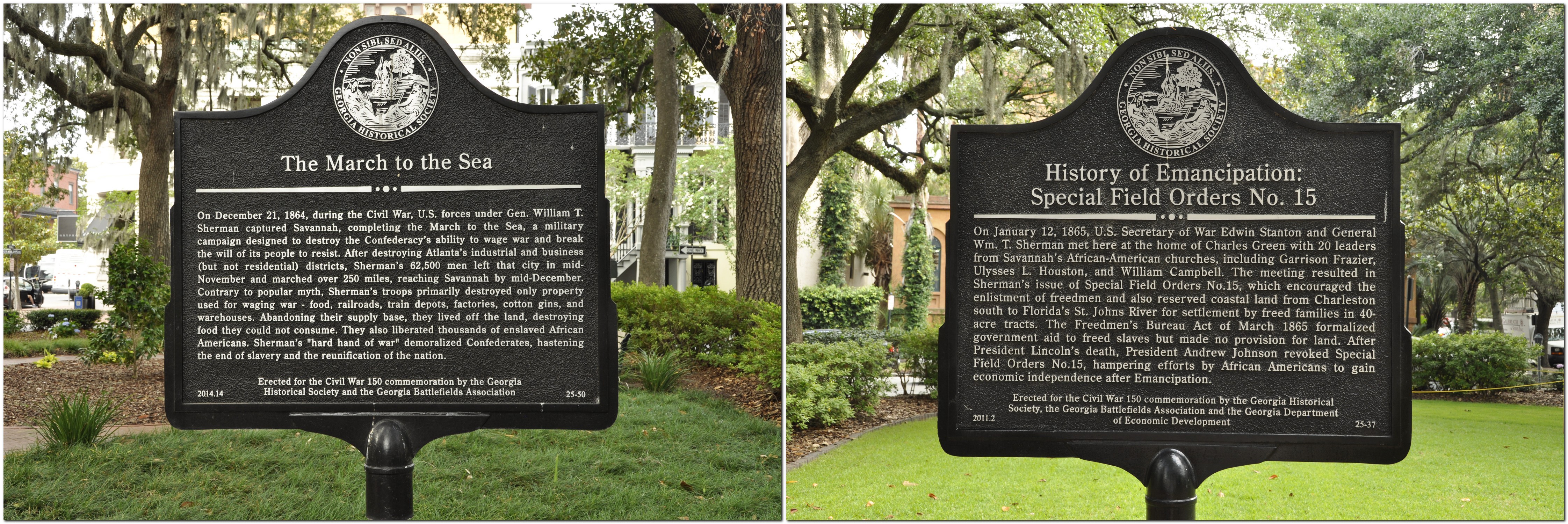
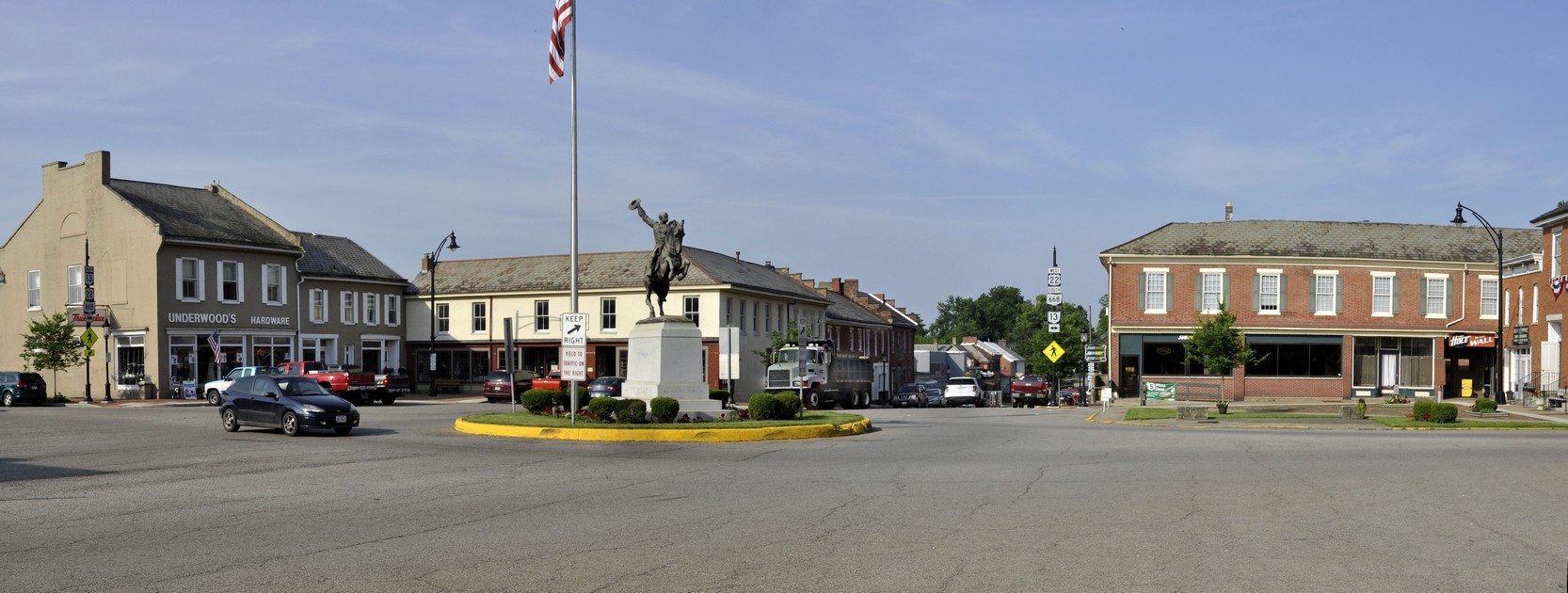
 Despite its incredibly bloody outcomes and destructive consequences, the American Civil War, 1861-65 holds a certain fascination. To a large extent, it was the first war to be extensively documented photographically, many of the images coming from the lens of
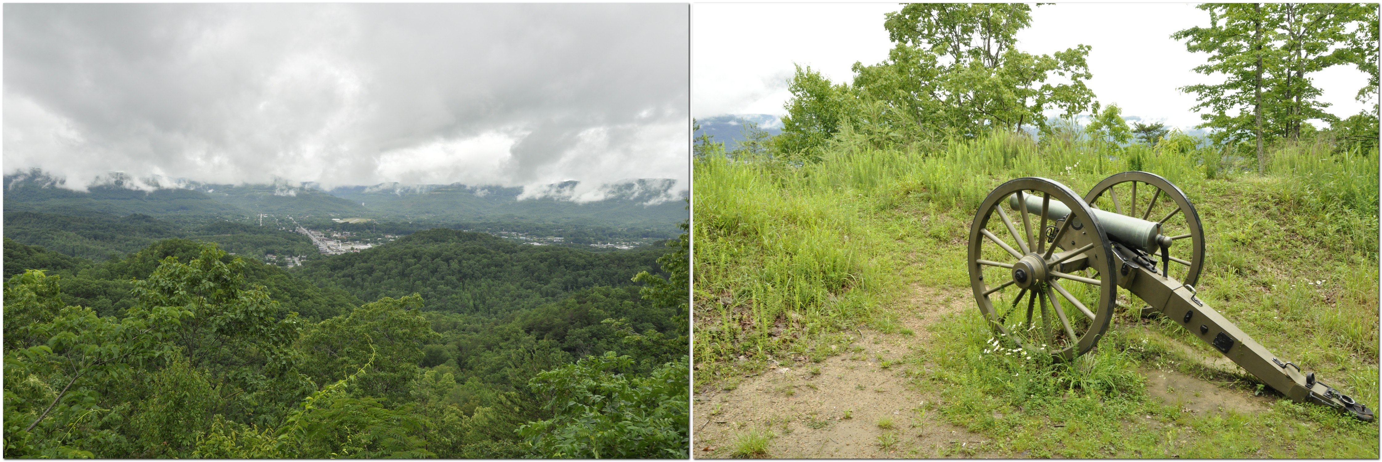
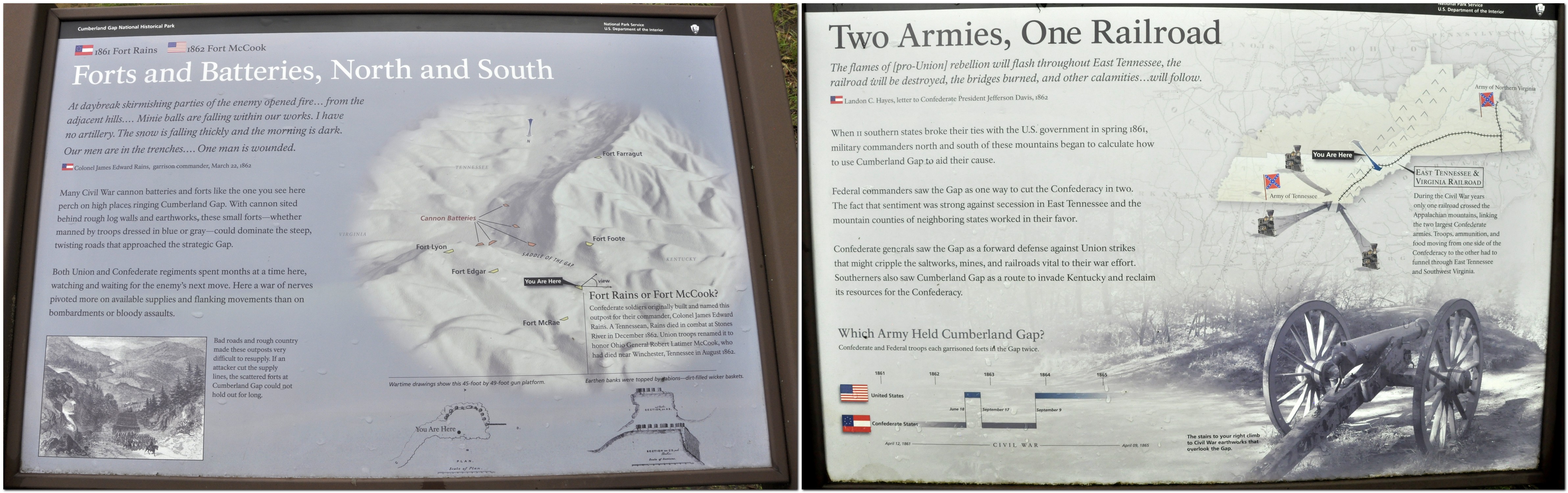
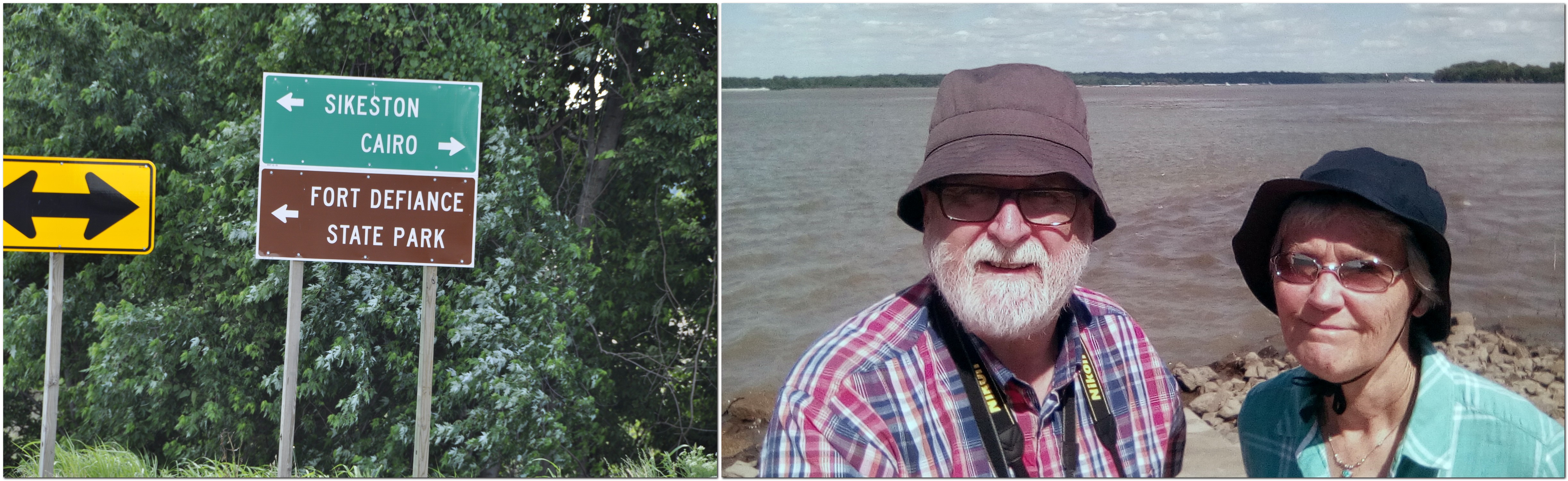
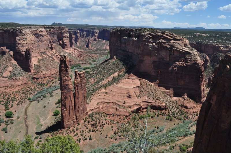


 takes some getting used to. I now understand that unless it specifically states not to turn, it’s OK to make that turn. Not something we’re used to in the UK. Red means red! And also, having to be aware that if you turn right on a red light, there may be pedestrians crossing as they will have right of way.

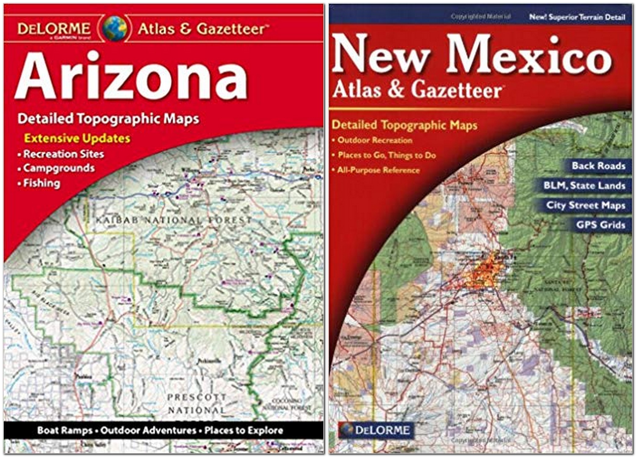
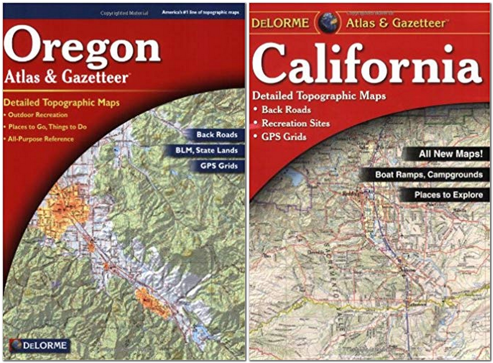
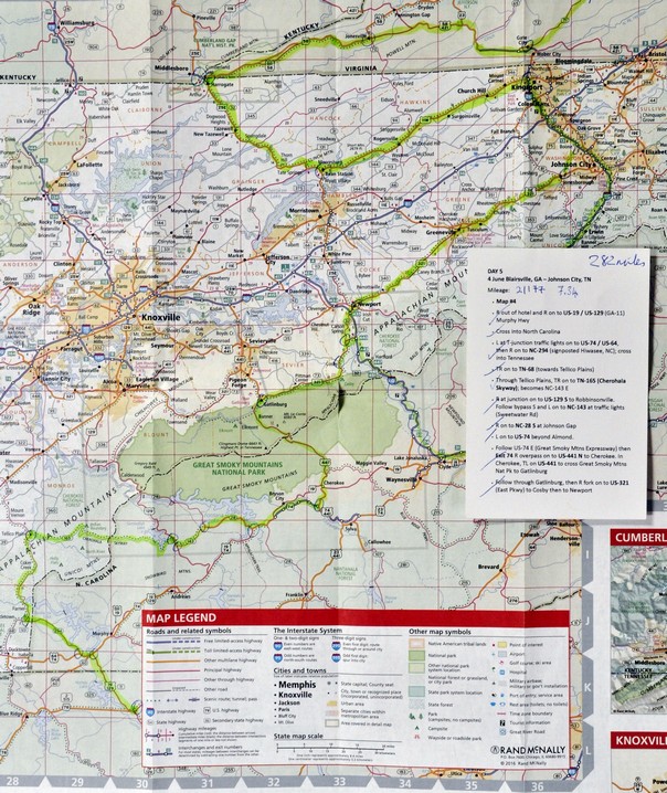
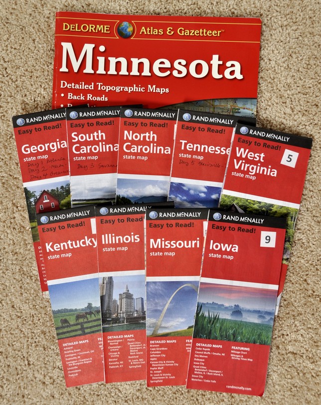


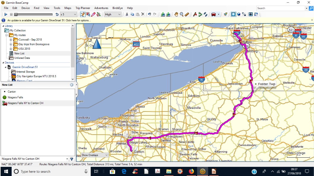

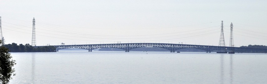
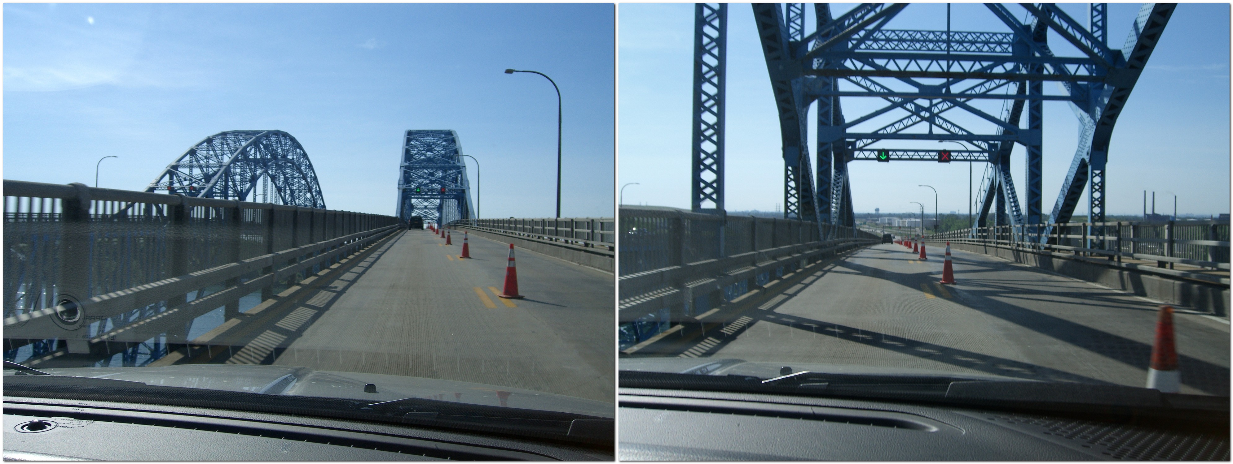


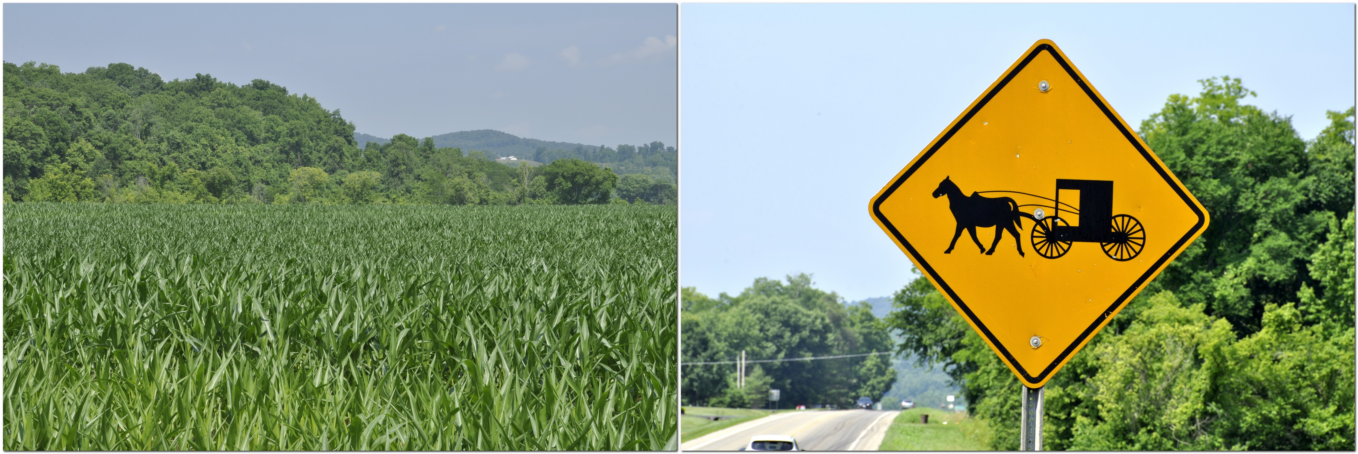
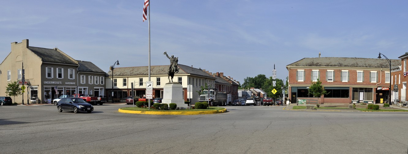
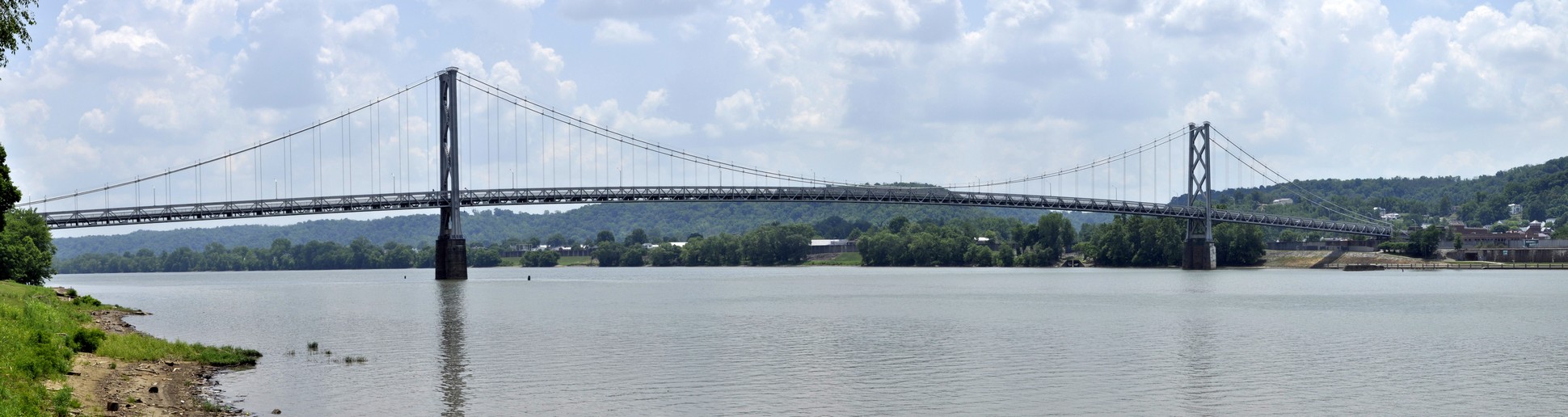
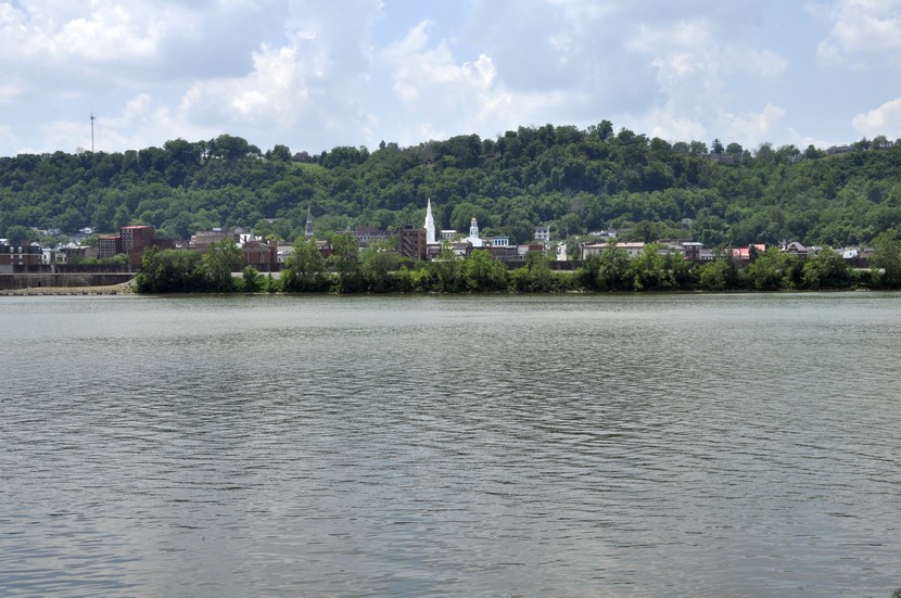
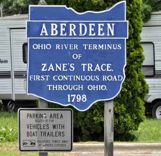
 Just north of the state line we took a short detour to
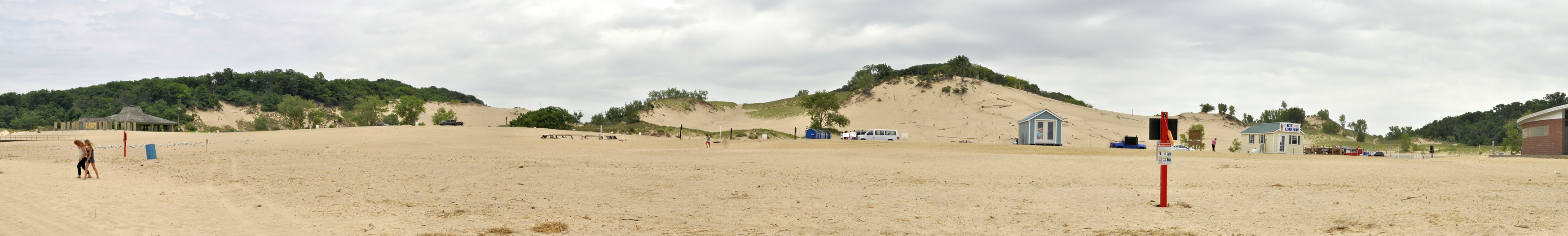


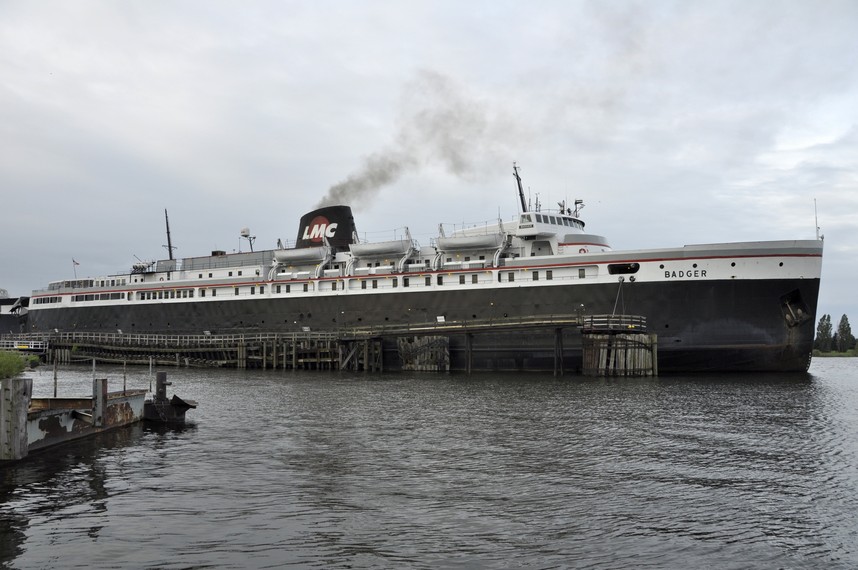
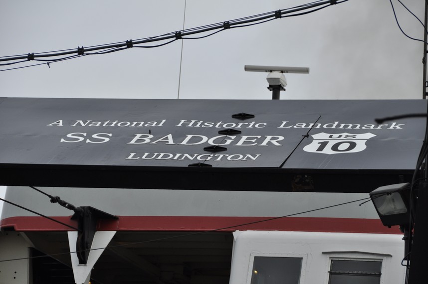
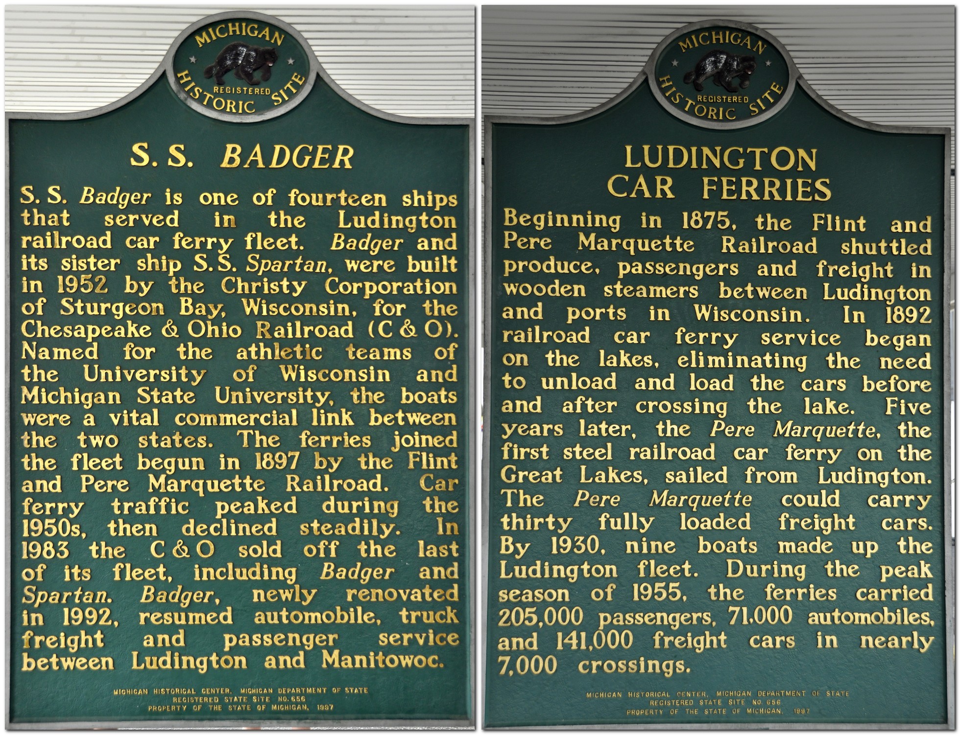


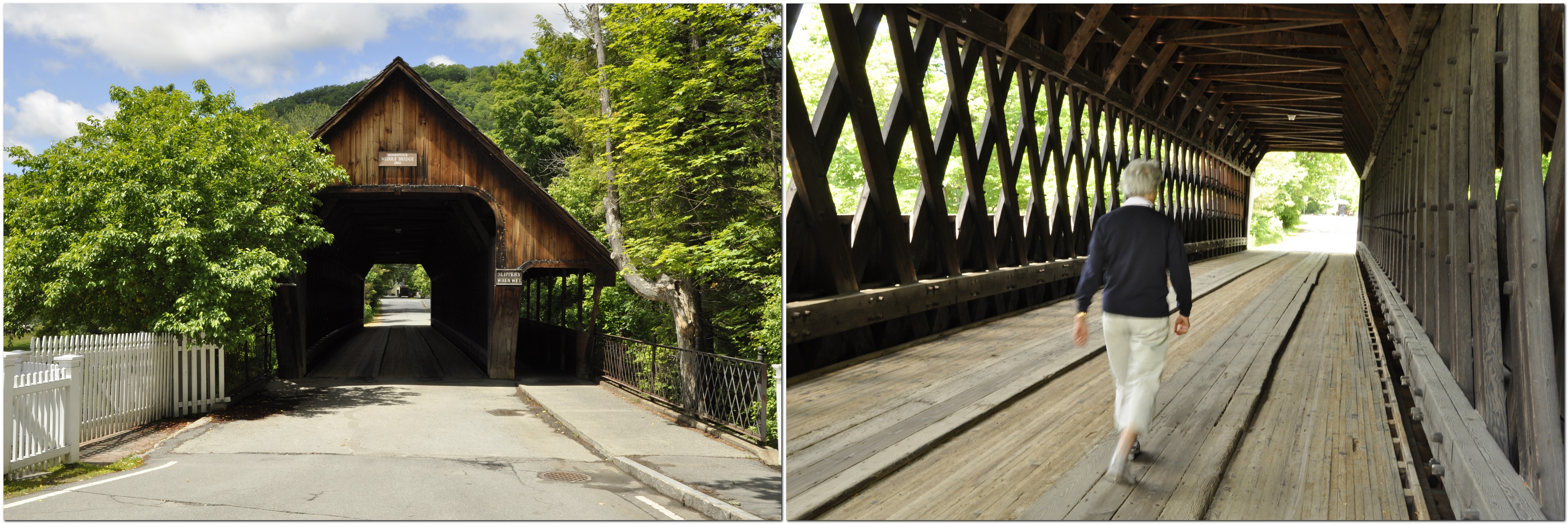
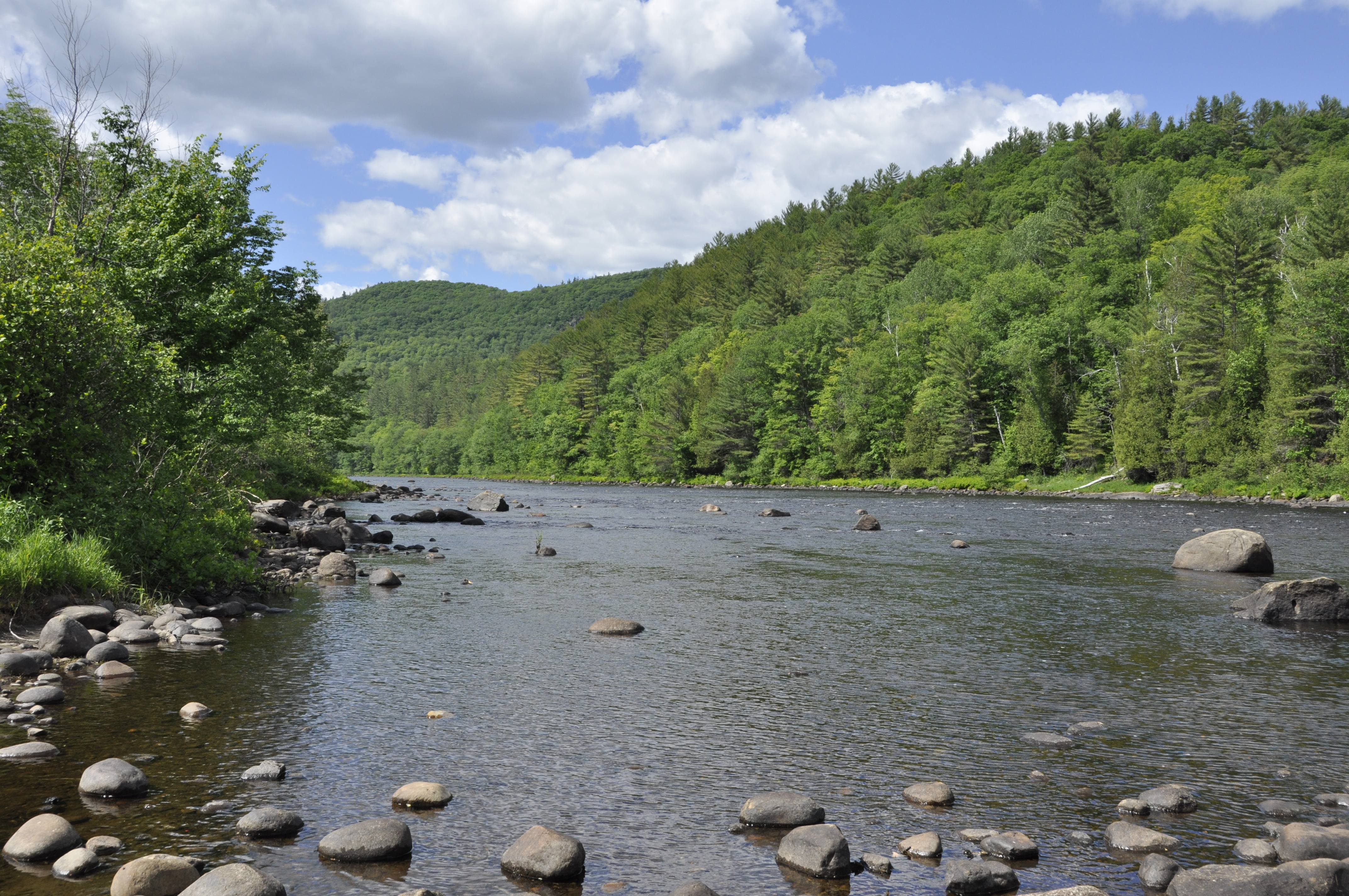


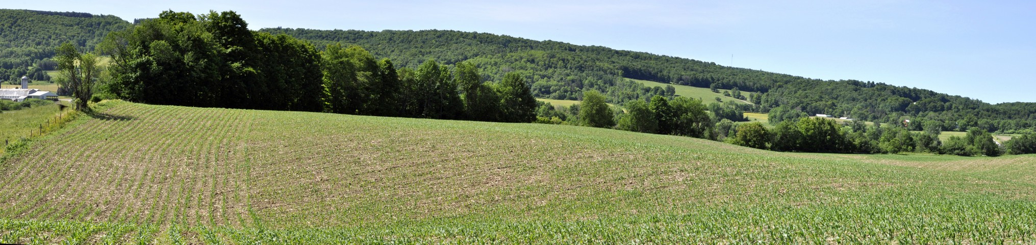


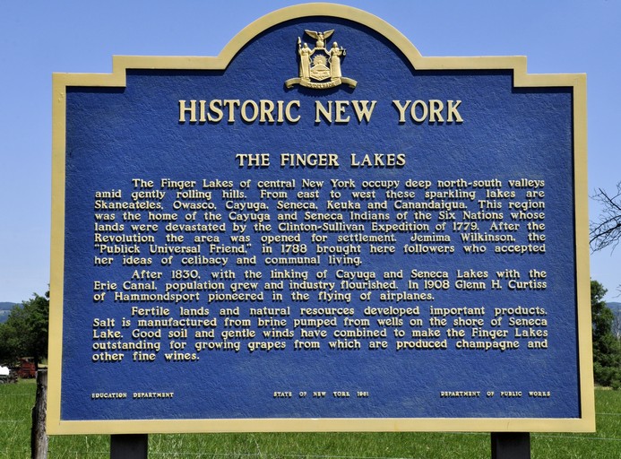
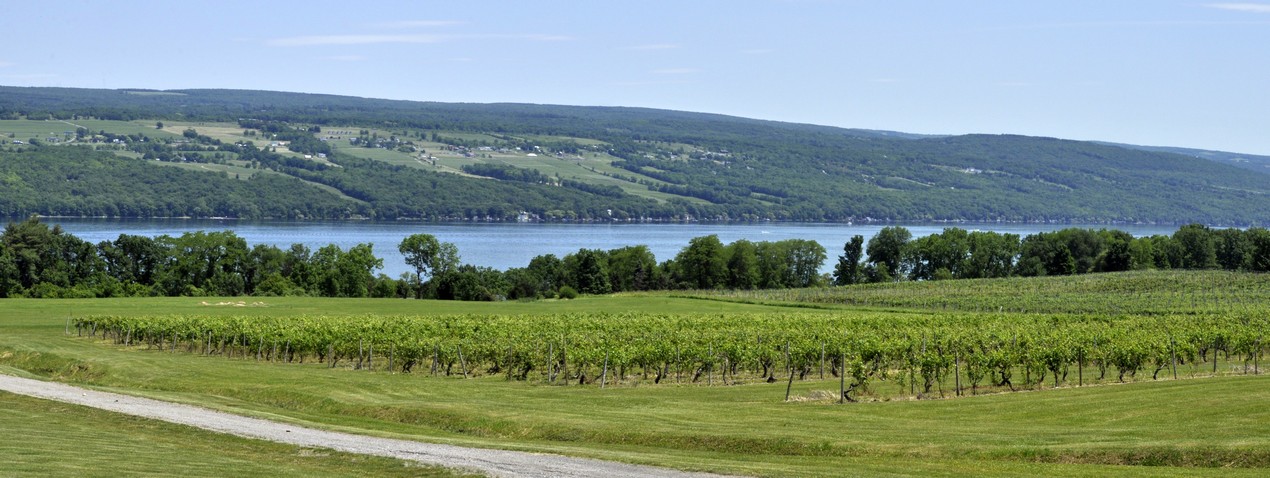


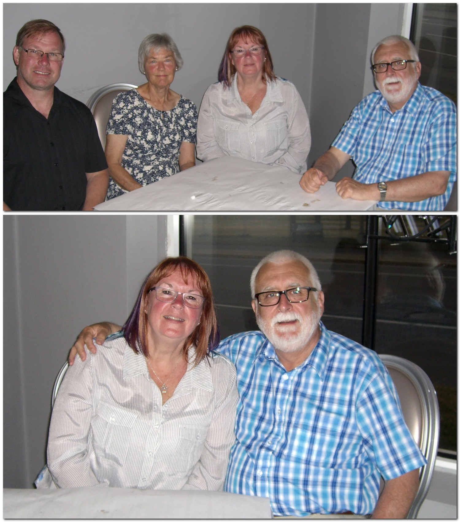
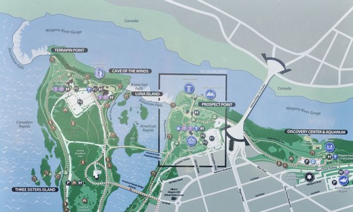


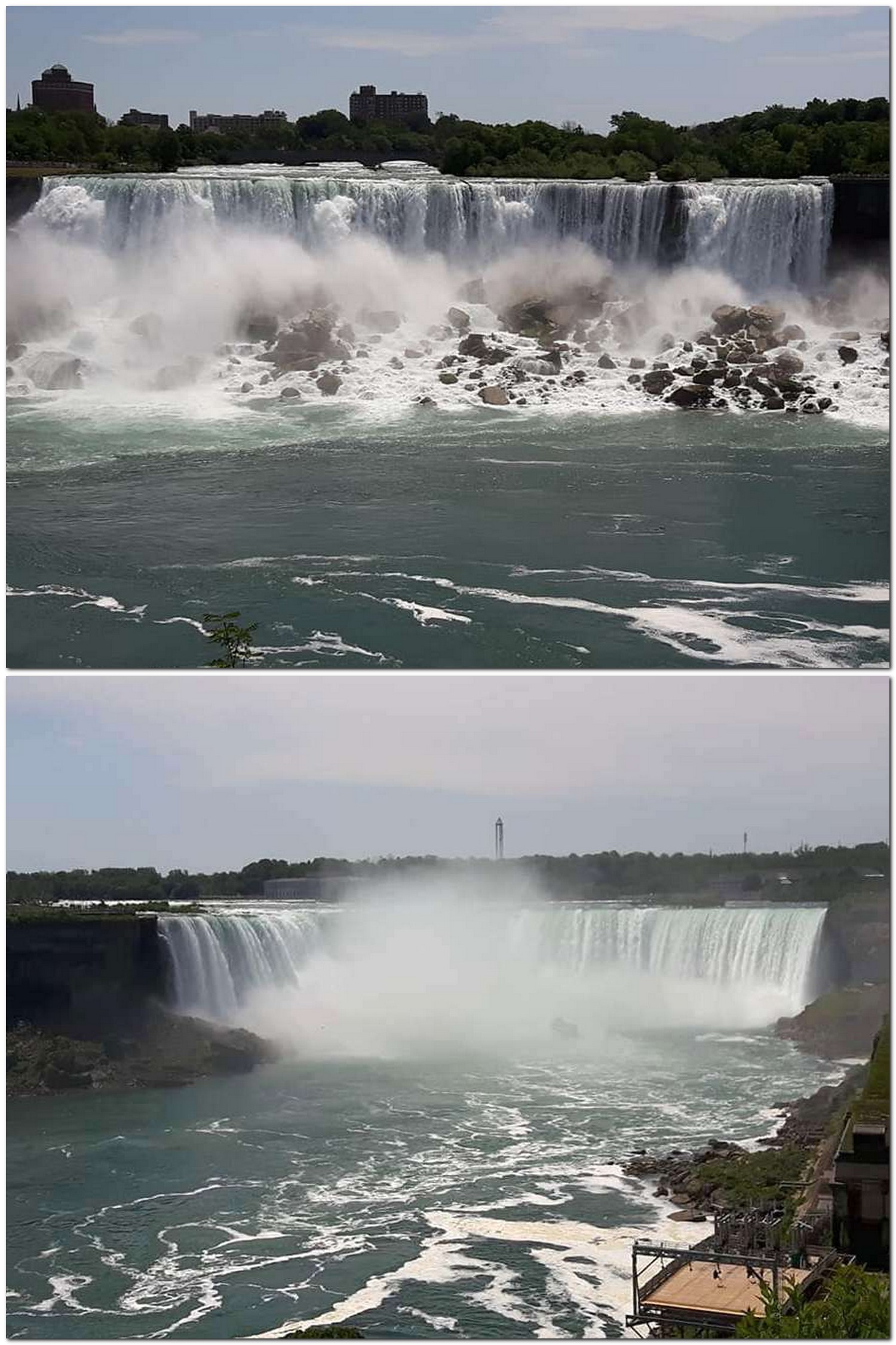


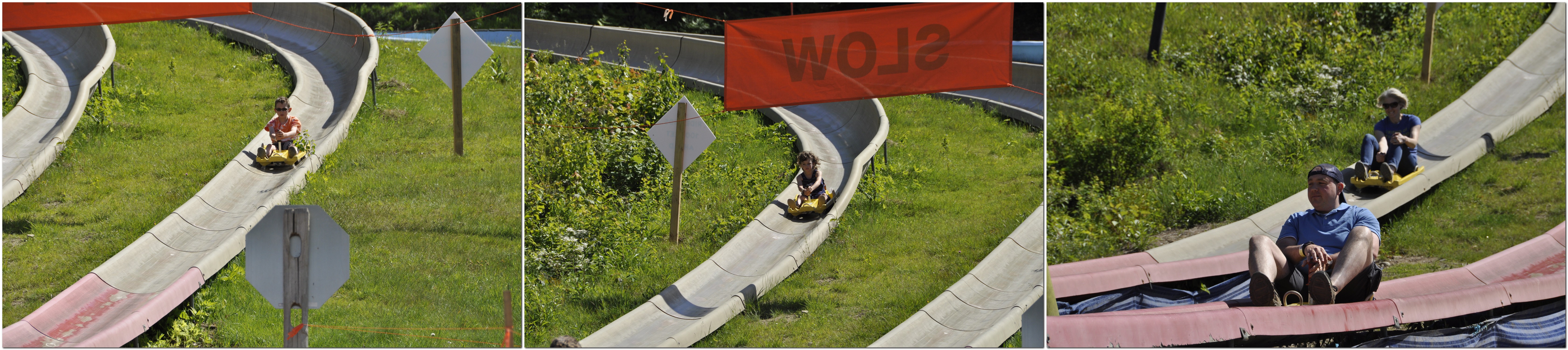


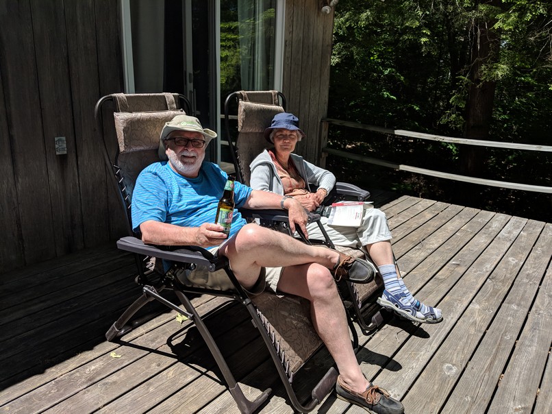

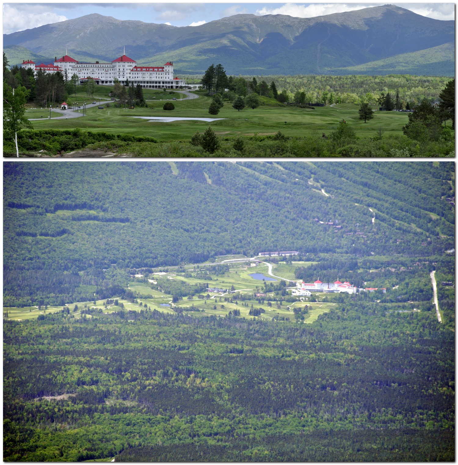


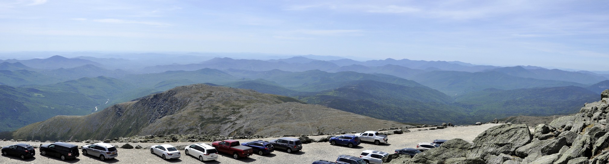

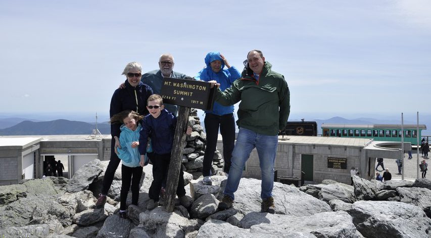
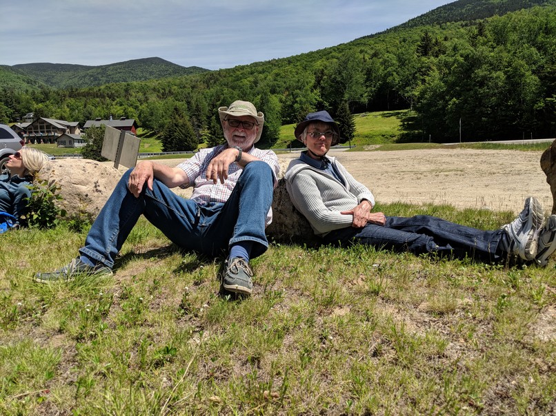


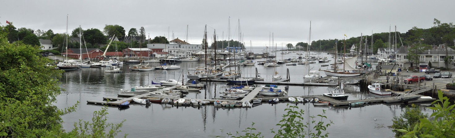
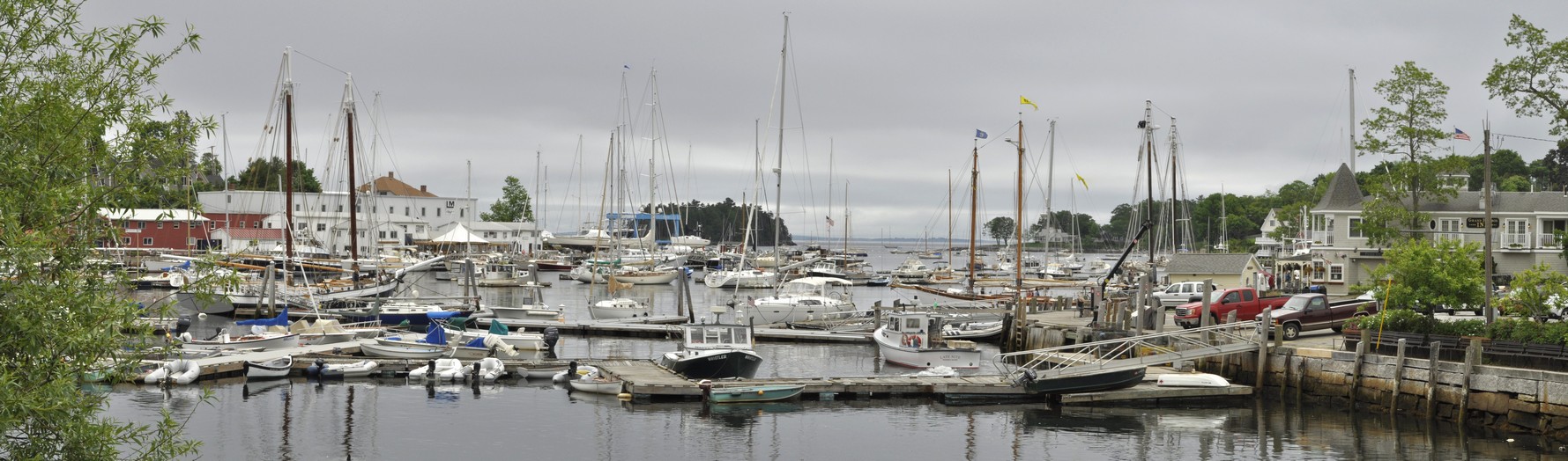


 There was a glorious view south from Whitcomb Summit, and some miles further on, just short of North Adams, there is a spectacular view north into southern Vermont, reminding us of the views we saw when exploring the


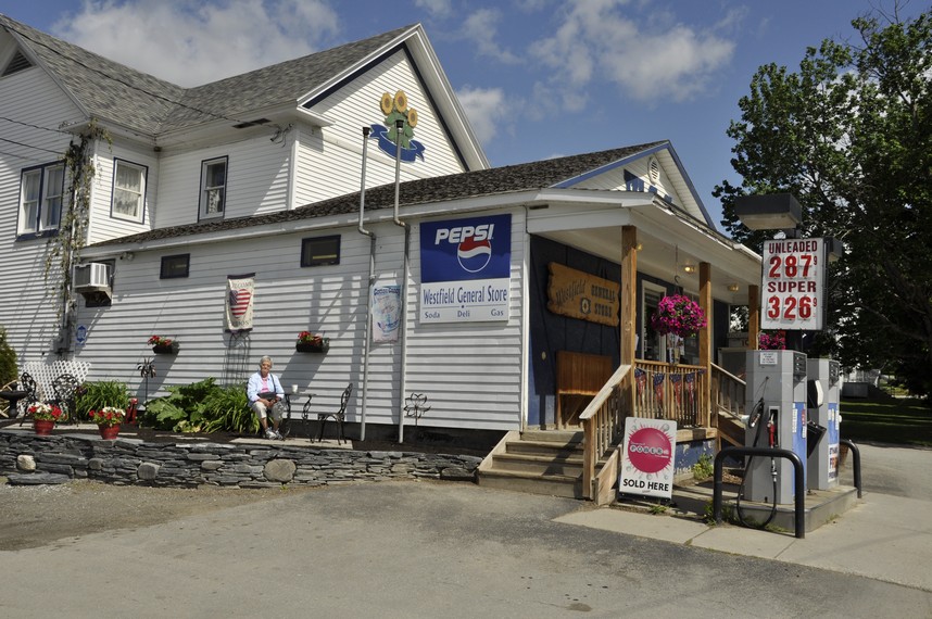


 A couple of months back, I enjoyed an excellent 672 page biography of Confederate Major General


 And now I have just finished another book, Noah Andre Trudeau’s 2008