
We moved to North Tyneside, just east of Newcastle upon Tyne, a little over three years ago, from our home of 39 years in Bromsgrove, Worcestershire to be closer to our younger daughter and her family who live in Newcastle. We had enjoyed living in Worcestershire; it’s a lovely county. But we also relished the thought of exploring the glorious northeast.
We have not been disappointed. It’s also a special delight living so close to the North Sea coast, just six miles to the spot where we usually park for a walk on Seaton Sluice beach.
Having lived in the Tropics for so many years, and enjoyed snorkeling and scuba diving there, swimming in the cold North Sea holds no attraction whatsoever. There are, however, hardier individuals than me.
But the magnificent coastline has everything: long, sandy beaches; dunes; rocks; and cliffs. And, as often as we can, weather permitting, we make a beeline for the coast.
So let me share with you some of the beauty of this coast that we’ve experienced so far. A coast that boasts some of the best beaches in the whole of the country, and many stunning views. Several parts of the coast are managed by the National Trust.
I’ll take you on a tour from north to south.
Lying just off the Northumberland coast, a few miles north of Bamburgh, the Holy Island of Lindisfarne is separated twice a day by a tidal causeway. We first visited Holy Island in 1998 when, on home leave from the Philippines, we spent a week touring the county. We returned in July 2022.
Holy Island was a centre of early Celtic Christianity, and the ruins of the priory still stand there. As does the Tudor castle (very much modernised) on a promontory.


At the entrance to the harbor (on Guile Point) are two obelisks, which can be seen just right of center in the image below.
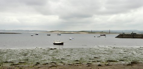
These are the Old Law Beacons, built in 1826 and are a navigational aid that, when lined up, guide sailors into the harbor through the safe channel.
Heading south, it’s not long before the early 14th century ruins of Dunstanburgh Castle on a remote headland come into view. The castle is only accessible on foot, just under 1½ miles north of the fishing village of Craster (famous for its kippers!) along a rugged rocky coast. The cliffs around the castle are home to an important colony of kittiwakes.


Embleton beach can be seen from the castle to the north, but we’ve not been there yet.


Just 5 miles south from Craster, the River Aln reaches the North Sea at Alnmouth, with sandy beaches flanking the estuary. On the distant horizon to the south lies Coquet Island, 1 mile off the coast from the fishing port of Amble (a town we have yet to explore).


Next south is Warkworth beach, a favorite of my daughter and her family. It’s just north of the town, with its 12th century castle, and the estuary of the River Coquet (which has its source high in the Cheviot Hills to the west). It’s a good walk through the dunes from the car park to the beach itself.


![]() Quite often after we have made one of our regular visits to the Alnwick Garden (where we have Friends of the Garden membership), we head down to the coast south of Amble (next images) to have our picnic lunch looking out towards Coquet Island, an important reserve managed by the Royal Society for the Protection of
Quite often after we have made one of our regular visits to the Alnwick Garden (where we have Friends of the Garden membership), we head down to the coast south of Amble (next images) to have our picnic lunch looking out towards Coquet Island, an important reserve managed by the Royal Society for the Protection of ![]() Birds (RSPB) and the most important breeding site in the UK for roseate terns.
Birds (RSPB) and the most important breeding site in the UK for roseate terns.
It has been badly hit by avian flu. Boat-landings are not permitted on the island even without the restrictions of avian flu.

 Just a little further south, and inland from the northern end of Druridge Bay lies Hauxley Wildlife Discovery Centre. There’s a circular walk (about 1¼ miles or 2 km), several hides from which to observe the numerous bird species, and the Lookout Café there serves an excellent cup of coffee.


We’ve visited there a few times, most recently less than a month back. On that visit we saw 36 different species of birds within the space of an hour: wildfowl, waders, and hedgerow birds. A complete range.
Druridge Bay must be one of the longest beaches in Northumberland, over 7 miles long, and backed by high dunes (which, in one location, is the haunt of naturists—presumably during the summer months only!). The Bay stretches from Amble in the north to Cresswell in the south. Inland from the beach, Druridge Bay Country Park covers an area of almost 66 acres (27 ha), with a large freshwater lake, woodland, and grassland and meadows, as well a stretch of the beach and dunes.


At Cresswell there are exposed—at very low tides—the remains of an submerged forest, but we’ve not yet had luck in finding them. The beach is flanked by rocky outcrops at both ends. Parts of the beach are also covered with sea coal which some of the locals gather.


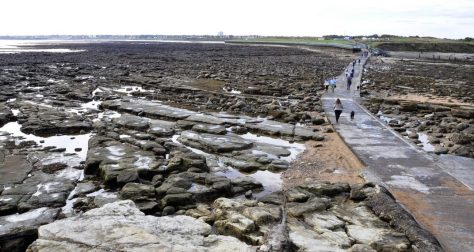
We haven’t yet explored any of the beaches between Cresswell and Blyth, but those south of Blyth as far as the mouth of the River Tyne are where we most often go for a walk. These include Blyth and Seaton Sluice beaches, St Mary’s lighthouse, Whitley Bay, Cullercoats, Long Sands Beach between Cullercoats and Tynemouth, with King Edward’s Bay nestling under the Tynemouth headland on which stand Tynemouth castle and priory, with a magnificent view over the Tyne.


The small harbor at Seaton Sluice, at the mouth of the Seaton Burn, was built by the Delaval family (of nearby Seaton Delaval Hall) in the 18th century to export coal and glass.
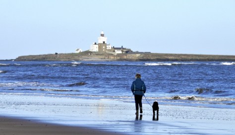
St Mary’s Lighthouse is only accessible across a causeway at low tide.
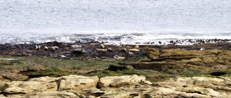
We regularly see a small colony of Atlantic grey seals, and the rocky outcrops there attract large numbers of waders like curlew and golden plover in autumn and early winter.
At the end of March this year, we took the Tyne Ferry to cross from North Shields to South Shields, mainly to visit Arbeia, the Roman fort there. But also to take a look at the entrance to the Tyne from the south and the beaches at South Shields.


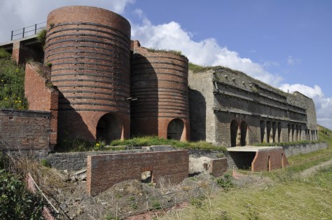
South of the South Shields beaches, crumbling magnesian limestone cliffs tower over the coast at Marsden and Whitburn. There are sea stacks and arches dotted along the coast, nesting sites for many sea birds. This stretch of coast is one of our favorites to walk. There is also the added attraction of Souter Lighthouse, visible from miles away.


The limestone is quarried, and in the 1870s a bank of 15 lime kilns was built to process the limestone, linked to the Whitburn colliery and Marsden colliery village, both of which have now been demolished.
The National Glass Centre stands alongside the River Wear in Sunderland.
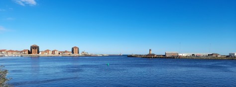
The mouth of the Port of Sunderland on the River Wear, across from the National Glass Centre.
It’s really worth a visit, and we enjoyed ours a year ago. There’s a long history of glass-making there, and it’s also connected to the establishment of early Christianity. Close by is the Saxon church of St Peter (below), one half, with St Paul’s in Jarrow, of the double Monkwearmouth-Jarrow monastery where the Venerable Bede, one of England’s greatest ecclesiastical scholars spent most of his life in the 8th century.

And talking of glass, in August 2022, Steph and I did some serious beachcombing at Seaham, south of Sunderland, searching for sea glass. I wrote about that visit in this blog post. The beaches there are part of the Durham Heritage Coast, which has been rehabilitated after decades of industrial abuse in the past. Blast Beach is where we found a nice source of sea glass, but the beach north of the town is supposed to be richer. We’ve yet to search there.


So, there you have it. At around 80 miles, and in many locations less than an hour from home, this stretch of coast must be one of the more interesting and beautiful in the country.
