‘. . . tomorrow do thy worst, for I have lived today’. (John Dryden, 1631-1700)

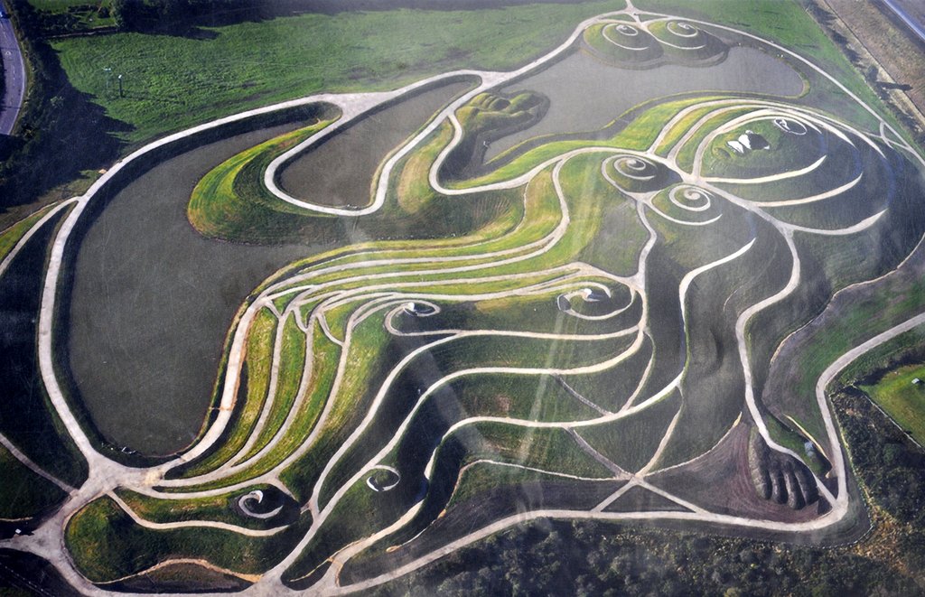
That’s a quotation from a poem by Poet Laureate John Dryden, and distant cousin to the family whose home we visited last week. Summer had arrived, and – having prepared a picnic – we headed 50 miles southeast to  Canons Ashby in Northamptonshire.

Canons Ashby House and estate was acquired by the National Trust only about 30 years ago. It had been offered to the Trust several decades earlier, but the Dryden family (which continues to have connections with Canons Ashby) was unable to provide the financial support needed to enable the Trust to take on the necessary long-term commitment. That changed around 1980 when the National Trust was able to secure public funds to acquire and restore the house that had already declined into a near terminal state of disrepair.

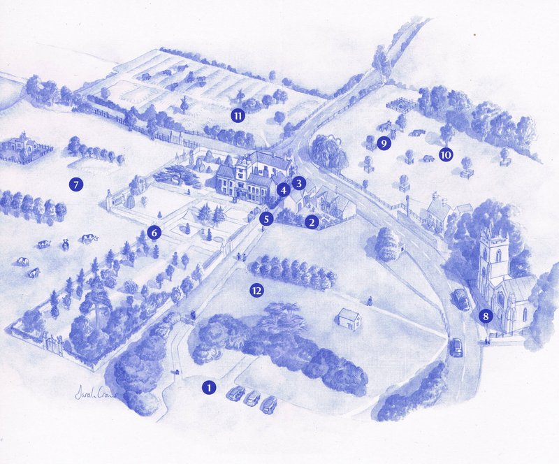
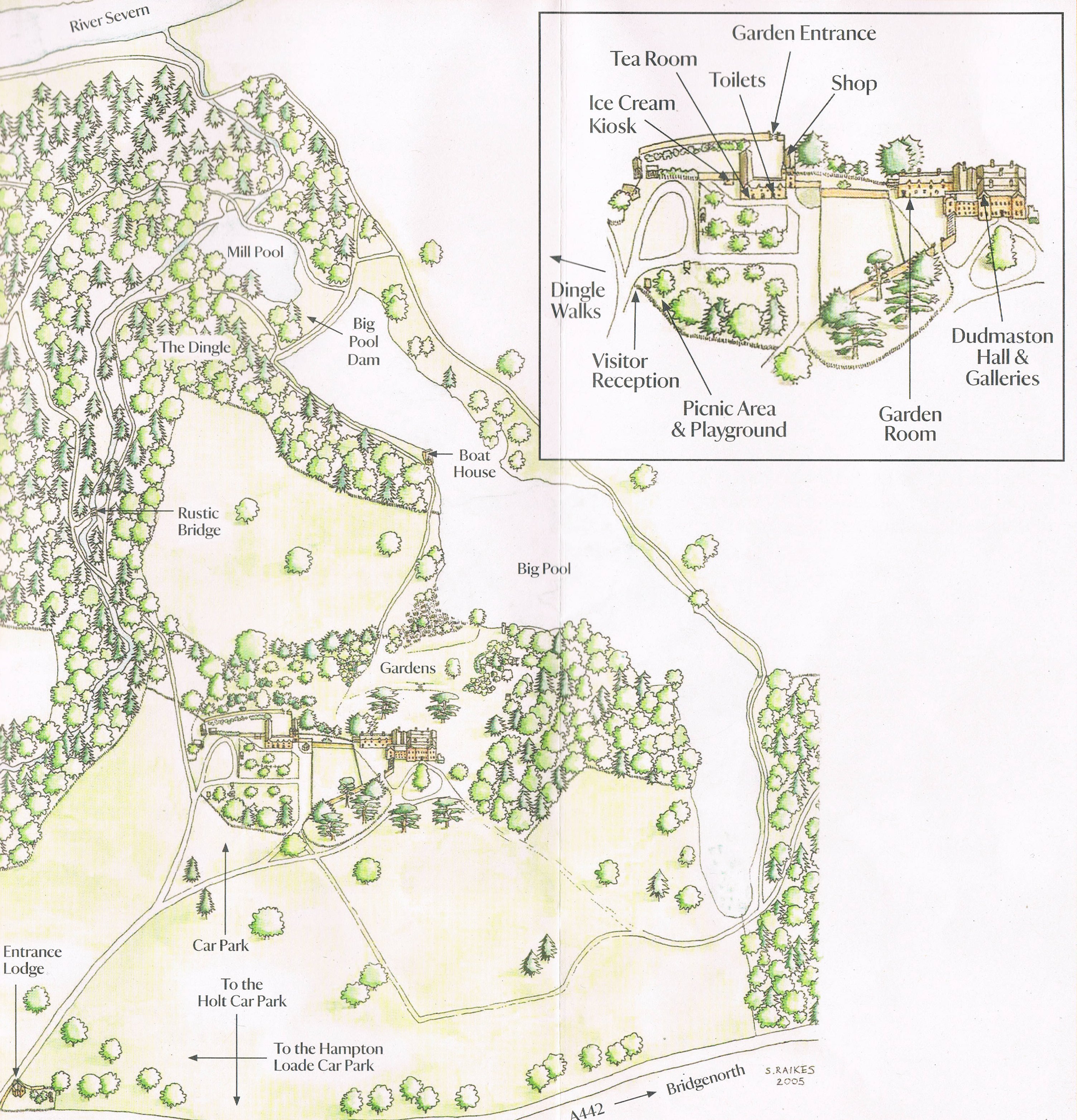
1. Car park; 2. Reception; 3. Toilets; 4. House entrance; 5. Garden entrance; 6. Steps into park; 7. Parkland; 8. Priory Church of St Mary; 9. The Norwell; 10. The Orchard; 11. Site of Medieval Village; 12. The Paddock.

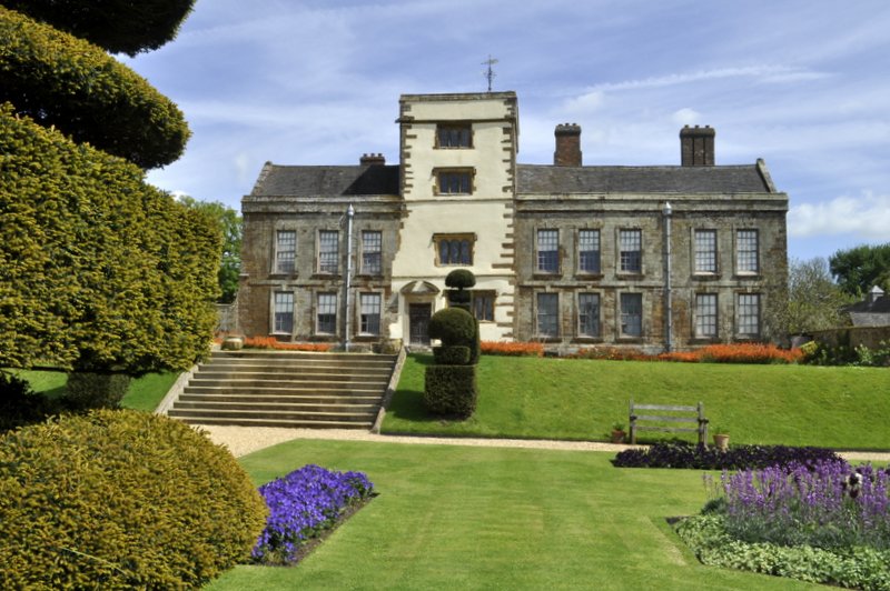
Three decades on and you wouldn’t believe what a transformation has taken place, and Canons Ashby is indeed one of the nicer National Trust properties that we have visited since becoming members at the beginning of 2011.

The 2500 acre estate and house was inherited by Sir Henry Dryden in 1837 (the 8th generation of his family to live at Canons Ashby), when he was just 19. Leaving his studies at Cambridge, he set about rescuing the house from more than 100 years of neglect, and made some extensive alterations to the rooms inside.

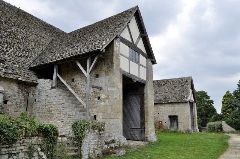
But the origins of the estate go much further back. An Augustinian priory was founded there in the 13th century, and the Priory Church of St Mary is all that remains today of a much larger settlement. And from Tudor times, and after the Dissolution of the monasteries, stones from the priory were used in the construction of the original parts of the house. The Priory Church is one of just a handful of privately-owned churches in England. The site of a medieval village lies to the north side of the house (11 on the site plan). Apparently, the Black Death badly affected Canons Ashby in the mid-14th century and more than half of the village died.

The house itself is surrounded by a small formal garden leading southwards towards the Lion Gate through what is now a vegetable garden. Beautifully manicured lawns and flower beds grace the south side of the house, but to the west is a walled garden, the Green Court, planted with yews, which provided the family some degree of privacy from outsiders and servants alike.

This slideshow requires JavaScript.

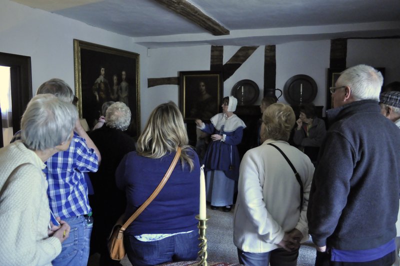
An archway (in part of the original Tudor building) leads into the Pebbled Court, and steps leading into the Great Hall. On the ground floor there are several rooms open to visitors: the hall itself, with an impressive display of swords and muskets on the walls and over the fireplace; the paneled dining rooms (with some impressive portraits including Sir John Dryden who erected paneling in many of the rooms in the 18th century); the book room/study, and a small room that was a museum developed by Sir Henry. Above the fireplace in the dining room is a mirror, slightly tilted forwards to enable anyone with their back to the window (but facing the fireplace) to see the garden (Green Court) outside.


This slideshow requires JavaScript.

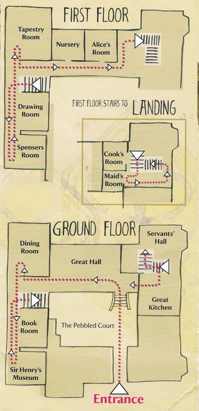
On the first floor, two rooms in particular are impressive: the Drawing Room with its fireplace and domed, plastered ceiling; and the Tapestry Room, a bedroom with beautiful tapestries hanging on the walls. In another bedroom, Spensers Room, some of the oak paneling has been removed to reveal the remains of some fine Tudor wall paintings.

This slideshow requires JavaScript.

Off a long gallery on the north side of the building there is a nursery, and the bedroom of Alice, Sir Henry’s only daughter – who became a well-known photographer who established a dark room in the cellars. Descending gingerly through low-framed doors and winding stairs in the oldest part of the house, there is the Servants’ Hall (once thought to be the original family dining room) and the kitchen (with its incredibly high, vaulted ceiling). The Servants’ Hall is rather intriguing, for a couple of reasons at least. The walls are covered in paneling, brilliantly decorated with coats of arms and escutcheons, some of which seem to indicate a link with Freemasonry (even though the Freemasons as such were not founded for a couple of centuries later). At least one window was bricked up – which previously had a view over the Green Court – so that servants could not watch the family at play.

This slideshow requires JavaScript.

From Tudor times onwards, the Dryden family were harshly Puritan, and supported Parliament during the Civil Wars of the 1640s. In the Green Court there is a statue of a shepherd boy reputed to have warned the Parliament troops stationed at Canons Ashby about the approach of Royalist forces. It is rather curious, therefore, that a portrait of King Charles I is displayed rather prominently in the dining room.

Canons Ashby is a delightful National Trust property. It feels like a family home, but the centuries of its history just ooze from the woodwork.

Silent witness to the English Civil Wars and the Industrial Revolution . . .

High above the gorge of the River Severn in the Shropshire countryside, and close to Ironbridge and Coalbrookdale lies Benthall Hall, an intriguing Tudor manor house dating from 1535, and home to Edward and Sally Benthall.  It has been in the Benthall family for more than 500 years – and saw some of the excesses of the English Civil Wars of the 1640s, as well as the birth of the Industrial Revolution at the beginning of the 18th century. It lies about 20 miles as the crow flies to the west of Moseley Old Hall. But whereas the latter was originally a typical Elizabethan half-timbered building, Benthall Hall is constructed from stone.

Since the house is still occupied by the family from time-to-time, only certain rooms are open to the public. Photography is permitted only in the ground floor rooms. Nevertheless, Benthall Hall has a certain charm – and still retains a ‘lived-in’ feeling. The main entrance is rather modest, but opens into a grand hall, with three rooms off to the sides. Two of these are beautifully paneled and the over-mantles are exquisitely carved. In one room, on the east side of the main hall, paint has been removed from the paneling to reveal the underlying wood in all its glory. One the opposite side of the building the paneling is still painted, and matches in with the plaster ceiling. It’s been suggested that the family decided to paint over the paneling after it was damaged during various skirmishes in the Civil Wars.

There is a small collection of beautiful Caughley porcelain which was manufactured in Broseley near Benthall Hall between 1775 and 1799. The gardens are quite small – the ubiquitous ha-ha, a wilderness area, cottage garden, and terraced plantings close to the house. A small church in the grounds is not currently open to the public, but now belongs to the National Trust and, after refurbishment, will become the reception center.


History is more than skin deep . . .

In  south Staffordshire, at the end of a very narrow lane, and nestling just under the M54, is an unprepossessing brick farmhouse.


Yet it was witness to a remarkable period of English history. Let me take you back more than 360 years to 8 September 1651.

It’s almost three years since Charles I was executed. The Lord Protector, Oliver Cromwell and his Parliamentarians, are firmly in control of the reins of government. Yet there is still widespread opposition to the Commonwealth of England, ruled as a republic, and Charles II (although not crowned for another decade) has just attempted to defeat Cromwell at the Battle of Worcester (just a few miles south of where I live) a few days before, chiefly with the support of Scottish troops. Instead, heavily outnumbered, Charles was defeated, and had to flee for his life. On that dark morning three days later he finally arrived at this Elizabethan farmhouse, Moseley Old Hall, with a small group of retainers.

Built in 1600  by Thomas Whitgreave (and in fact occupied by the Whitgreave family until 1925), it was one of his Catholic and Royalist descendants who gave sanctuary to Charles over the course of a couple of nights, even as parliamentary troops were scouring the countryside in their bid to capture the king. At one point they arrived at Moseley but were convinced by Thomas Whitgreave that he had nothing to hide; the six foot plus king was hiding upstairs in a secret priest-hole, just four feet square and a couple of feet or so deep – hardly a comfortable place for someone of Charles’ stature. In fact it was so uncomfortable that Charles chose to sleep fully-clothed in a four poster bed that is still there in the ‘King’s bedroom’ at Moseley Old Hall. Charles did manage to escape to France, and although in disguise, his height and swarthy complexion almost gave him away on a couple of occasions.

In 1651, Moseley Old Hall would have looked very different than it does today. It started life as a typical half-timbered Elizabethan building – looking rather like Little Moreton Hall that we visited last September. However, in the nineteenth century the outer skin of the half-timbered structure was removed, and replaced with the bricks – a veneer almost – that we see today. Once inside however, the house is pure seventeenth century, and many parts of the house have not changed in centuries.

Moseley Old Hall as it would have looked as a typical Elizabethan half-timbered building.

Moseley Old Hall is not a large property, but it has some real treasures. Many pieces of furniture are original to the property as are several of the altar ornaments in the attic chapel. Normally, Steph and I choose not to take a guided tour, preferring to wander around at our own pace. But because we could see that the hall might become quite congested, we did opt to take the tour, just fourteen of us in our tour. And it was worth every minute.

‘Mistress Whitgreave’ describing the features of an upstairs parlor.

On the ground floor the brew-house retains many of its original features, including a chute from the attic down which grain would have been dropped in preparation for brewing. There is an open kitchen and dining room, and a parlor with several original paintings.

The main feature on the first floor is the King’s bedroom and priest-hole. In the attic there is a Catholic chapel, which could only become an openly acknowledged feature once Catholics were permitted in 1791 to practise their religion under strictly prescribed conditions.

The gardens are not large, but there is an exquisite knot garden on the south side of the building. Alongside is a small orchard (with a lonely peacock wandering about). recently the National Trust has acquired a small piece of woodland to the west of the property and this has also been opened to visitors.

Moseley Old Hall was full of surprises – not what I had expected at all. Its royal connections certainly make it worthy of preservation as one of the National Trust’s properties. Had Charles been captured who knows what the dynastic consequences might have been. Another case of ‘What if?’

Around the world in 40 years . . . Part 10. Follow the yellow brick road

Not to see the ‘Wizard of Oz’ but to experience the ‘Magic of Oz’!

During the 19 years I worked in the Philippines, I had opportunity of visiting Australia on three occasions: once on business for 10 days in 2000, traveling to Canberra (and into the Riverina), Adelaide and Melbourne; and twice on vacation, with the whole family over Christmas and New Year 1997-98, in the Sydney area, and again in 2003-04 with Steph when we drove down the coast road, the Princes Highway, from Sydney to Melbourne. Our 2003 trip took some planning, and we certainly packed a lot in during the 10 days we were actually in Australia.

I had originally wanted to book a fly-drive holiday, but by the time we’d decided to take enjoy the long Christmas-New Year break in Australia, all the fly-drive holidays I found on the Internet were all booked up. So it was a case of DIY. I booked direct flights from Manila to Sydney on Qantas, and then began to search for hotels in Sydney and Melbourne, and all stops in between. Getting a flight was no hassle whatsoever, since we actually flew out of Manila in the evening on Christmas Day. Making a rental car reservation was plain sailing as well. But how to plan a journey from Sydney to Melbourne, and how to pace the trip and find suitable accommodation?

The fly-drive options on the web also provided a map of the itinerary and listed the hotels that would be booked – if they had been available. I looked for other hotels in the same towns but, it being Christmas, the was no room at the inn. Instead, I identified the nearest towns to those listed on the fly-drive schedules, and easily booked hotels all the way down to Melbourne, spacing our overnight stops – and to have plenty of time to make side-trips and stop along the way.

Manila – Sydney, dep. 25 December, arr. 26 December
Since the flight from Manila arrived early in the morning, there was plenty of time to get to our hotel (Park Regis City Centre) and even have a short rest before our friend and former colleague, Duncan Macintosh from IRRI (who was on home-leave in Sydney) dropped by to take us out to lunch. We headed to Bondi Beach, chose Ravesi’s Hotel on the main drag for an excellent fish and chips lunch, and (as it was Boxing Day) watched the yachts in the Sydney to Hobart Race sail past the headland. Later on in the afternoon, Duncan dropped us at the main rail terminal where we collected out tickets for the return journey from Melbourne.

Sydney, 27 December
We headed down George Street early, stopping at a few stores on the way to the harbour, where we spent a few hours exploring The Rocks (just under the Bridge), and finding somewhere to have lunch. There’s no shortage of places to eat at The Rocks, as in the rest of downtown Sydney. In the afternoon, we decided to take the river trip to Parramatta, which is about 25 km west of Sydney. There are still many colonial era buildings to see in the town.

Sydney – Nowra, NSW, via Royal National Park (180 km), 28 December
This was the start of our road trip to Melbourne. Heading south from Sydney, it wasn’t long before we made our first diversion through the Royal National Park, rejoining the Princes Highway just north of Wollongong.

There was plenty of time to sit on the cliffs at Stanwell and watch the aerobatics of members of the Sydney Hang Gliding Centre

http://vimeo.com/28658170

We also went to see the Blowhole at Kiama, and Seven Mile Beach, before finally reaching our first stop for the night at Nowra, staying at the Pleasant Way Motel (it had another name when we were there).

Nowra – Tathra, NSW, via Central Tilba (263 km), 29 December
Continuing south along the coast, we stopped off at Huskisson on Jervis Bay,  to see what are supposed to be the ‘whitest sands in the world’. Well, we only found out that fact afterwards, then Ulladulla, and for an ice cream in Central Tilba. The landscape around Tilba is lovely rolling country, dotted with small farms. It reminded me of the landscapes in the movie Babe – not surprising really as one of the main locations used was in the same coastal range north of Central Tilba.

We stayed at the Tathra Hotel – nothing to write home about, a regular motel, but it was convenient and relatively cheap.

We had dinner at The Wharf Locavore, now a coffee shop and art gallery but in 2003 also served dinner. It was great eating dinner with the waves crashing underneath – you could see them through the floorboards!

Tathra – Bairnsdale, Victoria (329 km), 30 December
Crossing into Victoria from New South Wales, we took a side trip into the forest, hoping to see some wildlife. We caught one glimpse of a kangaroo but that was about it. In fact, during our whole trip south we saw very little wildlife – probably because the weather was very hot and everything was hiding in the shade.

We stayed at a very nice hotel, The Riversleigh, in Bairnsdale. Unfortunately Steph had come down with a cold, but I managed to enjoy a nice cold beer or three, sitting on the balcony of our room.

 Bairnsdale – Wonthaggi, via Wilson’s Promontory National Park (392 km), 31 December
The highlight of this day’s travel was the excursion around Wilson’s Promontory, which is the southern-most point on the Australian mainland. Lots of Banksias to look at, and many other exotic plants that I had no idea what they were.

We headed to Wonthaggi that had once been a coal-mining center, long since closed down. We stayed at the excellent Jongebloed’s B&B on Berry’s Road south of the town, towards Cape Paterson. The B&B was excellent. The house had once been located in the town proper, but a couple of years or so before our visit, it had been cut in two, transported towards the coast and reassembled on a spacious plot of land, with an exquisite garden. We just managed to grab a bite to eat in the town before all restaurants were taken over for the New Year’s Eve customers. But we spent a wonderful evening afterwards on the beach near Cape Paterson, watching the sun go down over the Bass Strait – next stop Tasmania, then Antarctica!

Wonthaggi – Melbourne, via Warburton (280 km), 1 January
We didn’t take the direct route into Melbourne this day, but headed north through the Yarra Ranges, and came into Melbourne from the east from Yarra Junction, Warburton and Healesville. I don’t remember the name and exact location of our Melbourne hotel, but it was central and also close to the rental car deport where I dropped off the car the morning after our arrival. And we’d arrived – after a journey of almost 1500 km.

Melbourne, 2 January
We had only one full day in Melbourne so had to pack a lot in. It was very hot, but that didn’t deter us getting around on foot. In the morning we decided to take the Yarra River ferry to Williamstown, arriving back in Melbourne just after lunch. Then we walked along the Yarra River to the wonderful Royal Botanic Gardens, taking the tram back into the city. My legs were giving out by then.

Melbourne – Sydney (by rail), 3 January
The XPT (express passenger train) journey back to Sydney should have taken under 11 hours, departing Melbourne at 8:30 and arriving in Sydney just after 7 pm.

Due to 65 kph speed restrictions around Albury (just over the state line in NSW), because of the high temperature causing buckling of the rails, we didn’t arrive in Sydney until just before 10 pm – rather tired. Fortunately our hotel was just a few blocks from Sydney’s Central Station.

Sydney, 4 January
The next day we headed off to the Opera House and walked around Farm Cove to Mrs Macquarie’s Chair, from where there is a great view of the Sydney skyline, the Opera House and the Harbour Bridge. (In 1997 we’d watched the firework display over the bridge from the same viewpoint. Just one word to describe that. Spectacular!). Then, in the evening, we enjoyed a three hour Sydney Harbour dinner cruise, courtesy of Hannah and Philippa. We took a taxi back to the hotel – it was just too far to walk after a fine meal and a bottle of wine.

Sydney – Manila, 5 January
Our Qantas flight departed Sydney for the Philippines late morning, getting us into Manila in the early evening. Tired but contented we still had to endure the 2-3 hour journey back to Los Baños. Then it was a quick shower and into bed – I had to be in the office by 8 am the following morning.

And just to finish off, some panoramas from the whole trip:

Around the world in 40 years. Part 9. That is the trouble with flying: we always have to return to airports . . . (Henry Minizburg)

Maybe you’re a frequent flyer. Maybe not. How many of the flights you have taken were memorable? I hardly remember one flight from another (unless they were the two occasions when I was invited on to the flight-deck, on LH and EK flights, for the landing at Manila (MNL, RPLL). On the other hand, how many airport experiences – good or bad (mostly bad) – have you experienced?

Unless a flight was really bad – lots of turbulence, poor service, etc., you’re more likely to remember your airport experience. After all, for some journeys, you can spend more time getting to and from the airport, waiting for your flight to leave, or passing through immigration and customs on arrival, than you actually spend in the air.

Ever since I flew for the first time in 1966 – a short flight from Glasgow Airport (GLA, EGPF – then called Abbotsinch) to Benbecula (BEB, EGPL) in the Outer Hebrides on a British European Airways Viscount – I’ve passed through at least 180 airports worldwide. Since then, Glasgow has become quite an important hub for the west of Scotland, with many international airlines flying there. Benbecula is probably still the same – a small hut for a terminal building.

Now of all these 180 or so airports, some were just a transit stop en route from A to B; and others just a single visit or two.

On the other hand there are airports like Birmingham (BHX, EGBB) , Ninoy Aquino International Airport in Manila and Juan Santamaría International Airport in San Jose, Costa Rica (SJO, MROC) that I must have passed through many, many times – since they are/were my home airports for many years. And yet again others, like Hong Kong International (HKG, VHHH that replaced Kai Tak), the Twin Cities (Minneapolis-St Paul International, MSP, KMSP), or Narita in Tokyo (NRT, RJAA), are important hubs that I’ve passed through frequently over the years. Furthermore, I have traveled through MSP a lot (and still do) because my elder daughter Hannah and her family live there.

So what makes a good or a bad airport experience? And I’m sure we all have different criteria and tales to relate. As I was thinking about this, these are some of the ideas that came to mind:

  • the airport itself, its facilities, and capacity to handle passengers; travel to and from the airport; does it have one large terminal (such as Amsterdam Schipol, AMS, EHAM) or several like London Heathrow (LHR, EGLL) or New York JFK (a nightmare, JFK, KJFK) with all the headaches that can bring;
  • the check-in experience (depends on the airline to a large extent);
  • the immigration and customs experience;
  • connecting time between flights and the ability of the airport to handle tight schedules;
  • and then there’s the physical location of the airport and whether that can affect the takeoff and landing experience – as I’ll illustrate later on.

Some airports are well past their sell-by dates, and should have been demolished years ago. Although a new airport terminal was built at Manila a decade ago, it didn’t open for several years (a dispute with the company that financed its construction). Terminal 1 at NAIA is certainly not one of the most comfortable to travel from. The operators are always patching up the services, and there never do seem to be enough seats for everyone who needs one. But after almost 20 years of traveling through NAIA many times a year I can state unequivocally that the airport works and, most of the time on arrival, immigration, baggage handling and customs are really rather efficient. And of course (most of the time) one is greeted by a beautiful Filipino smile. I wish airport staff around the world were half as courteous and friendly as those you meet in Manila.

I was always wary of traveling through Murtala Muhammed International Airport in Lagos (LOS, DNMM) in Nigeria in the 90s. Immigration and customs staff could be quite menacing, and would always look for something in your bags to confiscate. The common question was’ What do you have for me?’ I’d always reply: ‘A big smile’ and then gave a big cheesy one. But they never did get anything off me. I wonder how things have changed since I was last there, more than a decade ago.

In Asia there has been an incredible airport boom – at Singapore’s Changi International (SIN, WSSS), Kuala Lumpur’s International Airport (KUL, WMKK) in Malaysia, and Bangkok’s Suvarnabhumi Airport (BKK, VTBS) in Thailand, and Hong Kong, of course. Another iconic airport, with a terminal building over a kilometer long, is Kansai International (KIX, RJBB) in Osaka, Japan, constructed (like Hong Kong) on an artificial island in Osaka Bay.

Some of the most difficult airports to pass through are in the USA. Many don’t have a transit area and even if you are only changing from international flight to another, you have to pass through immigration and customs. Not the easiest thing to do if you have a tight connection and there are a couple of other jumbo loads of  passengers waiting in the immigration queues ahead of you. US border staff are often not the friendliest. It must be tough sitting there facing a sea of faces every day. London Heathrow has become renowned for its difficult immigration, and that was a major concern ahead of the 2012 Olympic Games.

As I’ve been fortunate to travel business class on many long-haul flights, I’ve been able to take advantage of airline lounges in which to relax while waiting for a flight – a boon if there are delays. The Emirates lounges at Dubai International (DXB, OMDB) are superb.

In many airports it’s now difficult to view aircraft traffic easily from inside the terminal building. One of the best – when the airport was open – was the Cathay Pacific lounge at Hong Kong’s Kai Tak, with a view looking right down the runway from one end to the other. It was fascinating watching even the biggest jets manoeuvering above the apartment buildings and making the final sharp right turn to line up on the runway. It’s also quite an experience on board!

Now Kai Tak could be challenging for many reasons, as is the ‘new airport’ because of frequent crosswinds. But the landing on the short runway after a challenging approach at Tegucigalpa’s Toncontín International Airport (TGU, MHTG) in Honduras takes the biscuit. I flew in and out of there quite a few times in the 70s – never a comfortable experience.

I never visited Bhutan, but one of my staff, Eves Loresto, traveled there several times between 1995 and 2000 in connection with our Swiss-funded rice biodiversity project. Paro Airport (PBH, VQPR) in the heart of the Himalayas is considered one of the most demanding airports in the world, as this landing video shows. Only small jets operated by Drukair land there.

As I started this post, I suggested we’d all have our own stories to relate. And certainly while I have had some excellent flights (like when I was upgraded to First Class on my first A380 flight from DXB to BKK on EK), most of what I remember about those journeys has invariably to do with my experiences of the airports. What are yours?

A canal for all seasons . . .

20100515010One of my favorite walks is along the towpath of the Worcester and Birmingham Canal. Managed by the Canal & River Trust (formerly British Waterways) the canal is just a couple of miles to the east of where I live in north Worcestershire.

Construction of the canal began in 1792, and was finally completed in 1815. Connecting central Birmingham (to the north) and Worcester (to the south, on the River Severn to which the canal connects), there is a drop in elevation of 130 m (428 feet). Fifty-eight locks were needed to navigate the topography, including the 30-lock flight at Tardebigge (also close to my home), one of the longest flights of locks in Europe, as well as five tunnels (including the Wasthill Tunnel under the Lickey Hills, at almost 2.5 km), and three reservoirs to ensure a constant supply of water to the canal. Near Tardebigge is the old engine house – now converted to luxury apartments – that pumped water from the Tardebigge Reservoir and kept the water level of the canal topped up below Tardebigge Top Lock. North of this lock towards central Birmingham, there are no locks.

With the building of the railways in the 19th century, many of the canals were abandoned for commercial traffic and fell into disrepair. Not until the middle of the 20th century did travel on the canals become a major leisure industry. Canals were rehabilitated and opened up for navigation once again all around the country.

This slideshow requires JavaScript.

The canal towpath is a haven for wildlife, and during the different seasons there is always a great variety of birds to observe, on the water and in the vegetation that hugs the canal on the opposite side from the towpath.

So why is it called a ‘towpath’? Before the days of steam traction or today’s diesel engines, canal boats were hauled along by men or, quite commonly, large working horses. In the video below, a narrowboat on the Huddersfield Narrow Canal is being pulled along as in days of yore. The video also excellently illustrates just how a canal lock works, the effort required to raise or lower the water level, and open and close the lock gates.

As I stroll alongside the Worcester and Birmingham Canal I never cease to wonder at what was involved to construct the canals at the end of the 18th century and early 19th. With access to little or no machinery, the canals were hand dug by huge squads of workers – the ‘navvies’ (derived from ‘navigator’ or ‘navigational engineer’ – who later went on to build the railways). Can you imagine what effort was required, what the working and living conditions must have been like for the men (and presumably their families, because we do know that wives and children followed the navvies when constructing the railways)? Not only had the canal bed or ‘cut’ to be dug, but the bed had to be lined in many places with clay to make them waterproof and reduce or prevent leakage. Then there were the elegantly constructed and brick lined canal locks and bridges. The lock gates themselves, most often made from oak, had to be man-handled into place, weighing many tons.

Now while one can wonder at all this when the canal is open for business as it were, when it’s drained and closed for maintenance – as was the case recently at Tardebigge Top Lock – you really can appreciate the scale of the whole endeavor, and what it takes today to repair the canal even with access to all sorts of machinery.

This slideshow requires JavaScript.

It was colder than a witch’s tit . . .

Yes. It was that cold.

Having lived in some pretty hot places around the world over the past 40 years, I’d never experienced cold like that until then.

When? Well it was Christmas 2007, and Steph and I spent Christmas with Hannah and Michael in St Paul, Minnesota. And having flown in from the Philippines on Christmas Eve (and arriving in Minnesota almost before we departed the Philippines), you can imagine that super low temperatures came as a bit of a shock to the system. But I’m getting ahead of myself.

In all the almost 19 years in the Philippines we spent Christmas there, often heading to the beach for some well-deserved R&R, some diving, and generally lazing around under the tropical sun, except for four occasions when we visited Australia (twice) and once each to Hong Kong (and Macau) and Angkor Wat in Cambodia.

However, in 2007, I thought it would be fun to experience Christmas in a cold climate so, in my devious way, set about planning a Christmas break in Minnesota. Hannah had moved (as an undergraduate) to St Paul in 1998, and has settled there with husband Michael (and now children Callum and Zoë). Anyway, in about September of that year, I contacted Hannah and asked her if we could come and spend Christmas with them – if her Mum was willing to travel. Of course, Hannah was delighted at the idea and immediately said ‘Yes!’. Then I tackled Steph, asking her if she liked the idea of Christmas with Hannah and Michael. It didn’t take her long to agree – even though she has never been a fan of long-distance travel.

Unbeknown to either Hannah or Steph, I had already made Business Class reservations with Northwest Airlines, to depart on Christmas Eve (arriving to Minneapolis-St Paul, MSP, that same day), returning on New Year’s Eve, and back home on New Year’s Day. Originally our schedule was to fly to MSP via Tokyo (Narita) and Detroit, but about a week before flying seats opened on the direct Narita-MSP.

That was very fortunate as a major blizzard had moved through the Midwest just a couple of days before Christmas Eve and caused all manner of travel disruption, and our journey would have been even more tedious had we had to fly via Detroit.

There wasn’t a cloud in the a clear blue sky as we came into land at MSP, but we could see that a lot of snow had fallen within the previous 24-48 hours. Hannah and Michael were at the airport to meet us, and Hannah had brought along several items of warm clothing for Steph who didn’t have any in the Philippines since it was way below zero (Fahrenheit!). I was OK, since I often used to travel to the US or Europe during the winter months and had to have appropriate warm clothing to hand. From the airport we headed off to Target for a quick shop of extra clothes for Steph. We were amazed at how clear all the main roads were, eve tough there had been at least a couple of feet of snow.

Christmas Day was quite special. Not only was it nice to be with family, but it really did have a special traditional feel about it, sitting in front of a roaring log fire, opening presents, having a wee dram or three, and anticipating an excellent Christmas lunch of turkey.

We sat down to eat around 3 pm. It was just getting dark, the neighbors had switched on their Christmas lights (something that has grown in popularity here in the UK in the past few years), and then magic – it began to snow. Well, I’m now 65, and this for me was just about my first white Christmas. Even though there was food on the table, Steph and I had to go outside and experience that magic first hand.

Over the course of the next few days, Steph and I got to experience what ‘real cold’ was all about. It certainly was rather bracing heading out for a daily walk. But, by the same token, it was an experience that I thoroughly enjoyed, even though I don’t think I would recommend living somewhere that gets that cold.

All too soon our Minnesota sojourn was over, and on New Year’s Eve we headed back to MSP to catch a midday flight to Narita and on to Manila, arriving late at night on New Year’s Day. Great to be home, but pleased Continue reading

Around the world in 40 years . . . Part 8. SPQR

Senatus Populusque Romanus – SPQR.
The Senate and People of Rome. Those initials are still used on the modern-day emblem of the Rome municipality. It’s everywhere –  and a reminder of Rome 2,000 years ago.

But Ancient Rome’s incredible story is all around, woven into the very fabric of the city. Add to that the impact of the Catholic Church and the Renaissance on Rome’s architecture, and there’s an eclectic mix of ancient and modern, Christian and pagan, sacred and secular, and all things in between. Benito Mussolini also contributed to the architectural pot-pourri in the 1930s. Take, for example, the FAO headquarters building that stands beside the Caracalla Baths (Terme di Caracalla) at the foot of the Caelian Hill (one of Ancient Rome’s seven hills), looking over the Circus Maximus, the buildings on the Palatine Hill, and to the far west, the dome of St Peter’s Basilica. A rambling building in which it’s quite easily to get lost (and I have), it was originally Mussolini’s Department of Italian East Africa.

Views from the FAO roof terrace, looking north over the Circus Maximus towards the Palatine Hill, and the Colosseum (on the right) at the top of the Via di San Gregorio. You can just see the Arch of Constantine peeking above the trees, to the left of the Colosseum. The Victor Emmanuel II monument can be seen on the skyline on the left of the photo (click on this and other images to enlarge). Likewise on the photo below, the magnificent dome of St Peter’s dominates the Rome skyline.

Many visits to Rome
I’ve been traveling to Rome on quite a regular basis since 1989 when I made my first trip there. I must have been back there about 20 times or more while I was working at IRRI in the Philippines. That’s because Rome is home to three UN agencies: The Food and Agriculture Organization (FAO); the International Fund for Agricultural Development (IFAD); and the World Food Programme (WFP); as well of one of the 15 centers of the CGIAR, Bioversity International (formerly the International Board for Plant Genetic Resources – IBPGR, which became the International Plant Genetic Resources Institute – IPGRI, before becoming Bioversity International in the mid-2000s).

When it was first founded in the 1970s, IBPGR was located in the headquarters of FAO in Rome. And that’s where I headed in the late Spring of 1989 to sort out the funding for germplasm collecting work in the Canary Islands for one of my PhD students, Javier Francisco-Ortega. Then in April 1991, even before I formally joined IRRI as Head of the Genetic Resources Center, I was asked to represent the institute at the meeting of the Commission on Genetic Resources for Food and Agriculture held at FAO. And for the next decade I would travel to Rome every year, sometimes more than once, and in one year between 1993 and 1996,when I chaired the Inter-Center Working Group on Genetic Resources, I actually traveled to Rome five times.

But when I changed jobs at IRRI in May 2001, and took on responsibility for raising funds from the institute’s donor agencies, I still traveled to Rome each year to visit IFAD or attend inter-center director meetings hosted by Bioversity International.

So this is by way of background to explain why I traveled to Rome as frequently as I did.

And it’s a city that I came to know quite well, and to love the buzz of the place. Even so, I feel as though I’ve only scratched the surface of Ancient Rome, if the stories told by Cambridge classics professor Mary Beard on recent BBC TV programs are anything to go by.

So what is special about Rome?
Rome is a great city to get to know on foot – and I’ve walked miles and miles through the maze of narrow cobbled streets and piazzas, and along the River Tiber of course, heading towards the Vatican City and the glories of St Peter’s and the Vatican Museum. Even so, if you get sore feet, Rome has an extensive network of buses and trams on which you can hop; its taxi system is also very efficient (at least in my experience, although the 140 kph or more dash to the airport always had me on the edge of my seat). Despite all that walking, I still have only scratched the surface of Rome, ancient and modern. That’s because I could only get out and about exploring when I had a weekend free.

It also goes without saying that Rome is also a great place for food and wine – and not really over expensive. If you choose the right location. I very quickly found a number of restaurants that I would visit frequently, such as La Villeta (waiters all wear the AC Roma colors – family run, good atmosphere) and the Taverna Cestia (always had a good meal here) at the southern end of the Viale Aventino, or the Grottino da Rino (great antipasti) just down the street from FAO, close by the San Anselmo Hotel on the Aventine Hill where I often stayed. Near the Colisseum I often stayed at the Lancelot Hotel, and often ate in a typical tratoria, Luzzi in Via di San Giovanni in Laterano. And it’s this last one which really epitomizes the sort of restaurant I looked for: one where the locals were eating, with some tourists. But wherever you search, there are so many good eating places to choose from – serving simple and delicious food. I’ve only been to restaurants in Trastevere a couple of times – tends to be a little touristy, maybe catering to the tastes of a younger set.

The map below is centered on the Colosseum, but just zoom out and explore Rome!

Of course there are certain sights that everyone should visit: the Forum, the Trevi Fountain, the Spanish Steps, the Pantheon, the Piazza Navona, Villa Borghese, the Colosseum, and the Catacombs. I could go on; and I haven’t visited all these.

Dominating the skyline between the Caelian and Palatine Hills, the Colosseum, built by the Flavian emperor Vespasian and his successor Titus between AD70 and AD80, is a wonder of Roman architecture and construction (the Romans used lots of concrete). On a still night you can almost hear the lions roaring.

Overlooking the Piazza Venezia is the ‘wedding cake’ monument to Victor Emmanuel II – an iconic part of Rome’s skyline.

Here are some views of the Piazza Navona, the Trevi Fountain, and the Pantheon (where the former Kings of Italy are buried), and the Spanish Steps.

Finally, no visit to Rome is complete without at least a look at St Peter’s – even if it’s only from outside. What a stunning piece of Renaissance architecture. It’s worth a look inside (my photos are not so good), but depending on the season, the queue can be quite daunting – as can be that for the Vatican Museum. If you have the patience, the museum has some incredible treasures (to be expected from an institution that has dominated all parts of the world for two millennia). And from the museum it’s possible to walk in part of the papal gardens.

Hopefully, I’ll get a chance to visit Rome once more, and then take time to visit all those places that are still on my list. And I must remember to take a decent camera with me next time. In my dreams I’m eternally returning to the Eternal City.

A terrace, temples and time to enjoy them . . .

As I have blogged on quite a number of occasions now, Steph and I have enjoyed our National Trust membership since becoming members in early 2011. It certainly gives a focus for days out when the weather permits – and we’ve more than had our money’s worth in terms of membership fees versus entrance charges. So on our way back home last Sunday from our visit to the northeast we took the opportunity of stopping off in North Yorkshire. The weather forecast had been so-so, but it turned out to be a perfect late September day: bright and sunny, balmy even; almost an Indian summer.

In July we had visited Fountains Abbey, a derelict Cistercian abbey near Ripon. About 20 miles as the crow flies northeast from Fountains Abbey is another famous Cistercian ruin: Rievaulx Abbey, which is owned and managed by English Heritage.

But it wasn’t the abbey that we went to visit, but a delight of 18th century landscape gardening on the hillside above the ruins – Rievaulx Terrace and Temples. Constructed in the mid-18th century by Thomas Duncombe II (who had inherited Duncombe Park in nearby Helmsley), it provided a pleasant landscape from which to view the abbey ruins in the valley below of the River Rye (which also runs alongside another NT property, Nunnington Hall, about eight miles away to the south).

The grassy terrace, just below the brow of the hill, is bordered on the east side by a beech wood, and on the west – towards the abbey ruins – the valley drops away steeply, and is densely wooded, except for a number of avenues that were cut through the trees to provide views of the ruins below. You can see these quite clearly in the Google Earth satellite image below, just below the label ‘Mossy Bank Wood’.

There are two temples – that at the north end is an Ionic temple, open to the public at various times of the day; and the southern temple is a Tuscan round design, and is permanently closed.

We were very lucky to arrive just after noon, and the Ionic temple was still open. Visitors are restricted because of the delicate nature – and quality – of the interior furnishings. And what masterpieces the temple contains: original table and chairs, Royal Worcester china from the 18th century, the marble fireplace, and most important of all, the absolutely stunning frescoes on the ceiling. They quite took my breath away. The temple was used to entertain guests, with a kitchen in the basement.

The Tuscan temple has the most gorgeous painted plaster ceiling. The National Trust has placed mirrors on the inside of the windows and it’s therefore possible to view the ceiling.

But a stroll along the terrace reveals the Rievaulx Abbey ruins in all their medieval glory. I visited the abbey once in my Southampton student days during a walking holiday in 1968 on the North York Moors. And then in the 1980s, when our daughters were small, we rented a holiday cottage just north of Scarborough on the coast, and one of our trips was to Helmsley and Rievaulx.

This slideshow requires JavaScript.

Rievaulx Terrace and Temples were a complete surprise. Beautiful (especially on the day we visited), simple, and serene. If you ever get chance to visit, do make sure it coincides with one of the Ionic Temple opening times. You would surely regret missing out on those Georgian glories.

The Lady of the North

A couple of weeks ago I posted a story about the desecration of the landscape through industrial pollution, specifically the impact of coal mining.

Last week, my wife and I made the 225 mile journey from our home just south of Birmingham to Newcastle in the northeast of England. The route we took – M42, M1, M18, A1(M) – passes through many areas where coal mining was the main industry until quite recently. But as you speed past you would be hard pressed to realize that coal mining had ever taken place, such has been the rehabilitation of the landscape. Yes, in some places there are rolling ‘hills’, covered with scrubby vegetation, the remnants of the once dominating slag heaps associated with the deep mines. In general, the coal mining footprint is slowly and irrevocably disappearing.

Not so just a few miles north of Newcastle close by the village of Cramlington (where the musician Sting once taught at a local primary school before discovering his musical mojo). Just to the west of the village is the huge Shotton surface mining complex. And this is what it looks like from a slightly elevated location.

Not a pretty sight, but thankfully you can’t really see the extent of the open cast mining from ground level. It looked as though the mine operators were restoring some parts of the site, bringing in loads of top soil.

However, if you have £3 million, and are prepared to move 1.5 million tons of rock, gravel, clay and soil, then it’s possible to really make something from a ‘derelict’ landscape. And that’s what has been achieved at Northumberlandia (from where the photos above were taken). Undoubtedly one of the largest landscape sculptures of a figure – in this case a reclining nude Lady of the North, Northumberlandia – in the world, it took a couple of years of landscaping to achieve a truly remarkable design, and was opened in September 2012.

An aerial view of Northumberlandia, with her head on the right and feet on the left.

An aerial view of Northumberlandia, with her head on the right and feet on the left.

1. Viewing points. 2. Head. 3. M’lady’s breasts. 4. Hands. 5. Hip. 6. Knee. 7. Ankles.

Rising to 100 feet apparently at the head, there are over four miles of paths winding around the lady, with viewpoints from M’Lady’s breasts, hip, knees and ankles. Her right hand is raised in a salute with the index finger raised. There are three ponds to one side, which will surely become colonized by reeds and other water-loving plants and become a haven for wildlife. Already there is quite an impressive array of wild flowers on her flanks.

The paths have been laid out to provide easy access for everyone; the gradients are steeper in some sections than in others. Entry to Northumberlandia is free, but one is asked to contribute towards car parking – £2 is the suggested fee. It was a beautiful day when we visited last Saturday along with daughter Philippa and her husband Andi, and sons Elvis and Felix. Here is a small selection of the photos I took. This is what you see from ground level. It’s well worth a visit.

Around the world in 40 years . . . Part 7. Letting the train take the strain

trainI love traveling by train.

And were it possible to travel everywhere by train, that would be my preferred mode of transport. There are many journeys I would love to take, particularly on the luxury trains such as the Orient Express, the Blue Train in South Africa, or the Eastern & Oriental Express from Singapore to Bangkok (I have the time, but don’t have the budget), as well as others across the USA and Canada through the Rockies, or in Australia (from Adelaide to Darwin on The Ghan, for example or across the Nullarbor Plain from Adelaide to Perth on the Indian Pacific).

When traveling on business for IRRI in Europe to visit the institute’s donor agencies, I most often traveled from city to city by train rather than flying. More relaxed, comfortable, convenient, and a better use of my time than sitting in an airport departure lounge wondering if the flight would depart on time, never mind – if there was inclement weather – if it would depart at all. The longest journey I made (twice), over about two weeks in total, was : Bromsgrove (my home town) – Birmingham New Street – London Euston / London Waterloo – Brussels (on the Eurostar) – Bonn (on the Thalys to Cologne) – Basel (down the Rhine valley) – Bern – Milan (cutting through Alps and along the Italian lakes such as Como) – Rome (but return to Birmingham by air). Seat reservations are a requirement on many European train journeys – none of this ‘sardine’ travel so typical on a number of commuter lines in the UK (and even on long distance trains at some times of the day or on holidays).

Braunschweig to Gatersleben and Berlin
In the late 1980s, while I was still working at the University of Birmingham, I decided to visit two genetic resources programs in Germany – at Braunschweig (in West Germany) and Gatersleben (in East Germany). This was before the Berlin Wall had been pulled down. It was actually quite easy to cross over from the West to the East, and at the crossing, border guards came on board to check documents. I must admit that I wasn’t particularly relaxed until my passport had been checked, all was in order, and I continued with my journey, via Magdeburg, Halberstadt, to Gatersleben.

Gatersleben is home to the Leibniz-Institut für Pflanzengenetik und Kulturpflanzenforschung (IPK-Gatersleben) with one of the most important crop genebanks in Europe. I was made most welcome by the head of the genebank, the late Dr Christian Lehmann and his colleagues Karl Hammer and Peter Hanelt (and other genebank staff). It was a memorable visit, particularly walking through the impressive summer regeneration plots of cereals such as wheat, barley (seeing hooded barleys for the first time) and oats, and other crops, and discussing crop evolution and diversity with Dr Lehmann.

My return journey took me to Berlin, where I left the train at Schönefeld Airport station (in the southeast of Berlin), and crossed through the Berlin Wall by taxi, to arrive at the airport in the West. I’ve remembered that as Templehof Airport, although it might have been Tegel.

Stahleck Castle at Bacharach

The Rhine Valley
I’ve visited Bonn on many occasions. Flying into Frankfurt I could have taken the direct, fast train to Cologne via Bonn. But it’s much more enjoyable to take the (slightly) slower train that hugs the River Rhine. What magnificent views of the vineyards that embroider the steep slopes either side of the river. And also the fairytale castles that  cling to rocky outcrops. The river is a watery motorway, with barges flying the flags of many nations, many carrying a motor vehicle for use at ports along the journey.

Bern to Montpellier (via Geneva, Lyon, Valence and Avignon)
For my second visit to Montpellier in southern France in the early 90s I traveled from Switzerland’s capital Bern down the Rhône Valley. It’s not a particularly fast journey, because the line snakes along the valley. But the views of the surrounding mountains are simply stunning – impressive precipices over which plunge waterfalls for hundreds of feet.

Switzerland
Even 30 secs is late for Swiss trains. They have remarkable punctuality. I’ve spent time visiting various places throughout the country when I’ve had a weekend to spare during my business trips. Bern is a good base with excellent rail connections. Close by is the Jungfrau, and although I’ve not taken the train to the summit, I have twice been on the funicular up to Wengen (starting the journey in Interlaken), then the cable car up to Männlichen where there is a fabulous view of the Alps (Eiger on the left). From Männlichen you take the cable car down to Grindelwald, and then the train back to Interlaken.

The view from Männlichen, with the north face of the Eiger on the left.

Then there was the weekend I decided to see the Matterhorn in May 2004. Leaving Bern early in the morning, we headed through the Alps to Brig where I transferred to the local line up to Zermatt. What a fabulous day out – made even better by the train journey!

High speed journeys
Eurostar, Thalys or TGV. There’s something impressive about these high speed trains across Europe. I’ve been through the Eurotunnel a couple of times, and joined the Thalys (Belgian equivalent of the TGV) to Cologne or Amsterdam (and return). The German ICE (shown here) is incredible – fast, silent and very comfortable. I took this the first time from Amsterdam Central to Cologne, and had a seat just behind the driver’s cab. When he didn’t want to be distracted the driver could make the glass screen turn translucent. Otherwise it was fun watching the train eat up the kilometers from the driver’s perspective.

One thing I do remember from my first TGV from Paris-Gare de Lyon to Montpellier, is the speed we reached south of Paris to Lyon, over undulating terrain. It was the first time I had that sinking feeling on a train – just as in a plane descending – as we went over one hill and down the other side. South of Lyon, the TGV proceeds at a more stately pace since the line follows the river.

Yangon to Yezin, Myanmar
I visited Myanmar (Burma) just the once in about 1997 – I don’t remember the exact year. I had received a grant from the Swiss government of more than US$3.3 million to develop and manage a project to collect and conserve rice varieties and wild species in South and Southeast Asia and sub-Saharan Africa. Although Myanmar had been essentially closed to the outside world for many years, IRRI had retained a presence there, with a liaison scientist and small office. Given the importance of rice in that country, it was appropriate to see what might be done in terms of collecting rice germplasm. So with my colleague Eves Loresto we  traveled the 250 miles or so north from Yangon (Rangoon) by train to Yezin where the Central Agricultural Research Institute (and university) is located, with its large rice genebank. Our outward journey was during the day, and although very slow (about 10 hours) it was interesting traveling through the vast plain of rice paddies. Several times the train was reduced to a snail’s pace as the track was flooded. We returned to Yangon a few days later by the ‘sleeper’ – I use that term advisedly, because I didn’t get much sleep and the accommodation wasn’t exactly desirable. At Yezin we had to evict a group of about five passengers who had commandeered our cabin.

Melbourne – Sydney
On Christmas Day 2003 Steph and I flew to Sydney, arriving the following morning, Boxing Day. We spent a couple of days looking round the city (we’d been there for the first time in December 1998 and saw the New Year in watching the fireworks display over the Sydney harbor bridge).

Anyway, on this second trip, we took a memorable road trip to Melbourne (about 1,000 miles) along the coast road with several diversions inland. After a couple of days in Melbourne we returned to Sydney by train. It was scheduled for about nine hours, but due to the heat (>40C) between Albury on the Victoria-New South Wales border and Wagga Wagga (in NSW) (about half way through the journey), the train speed was seriously reduced because the track was buckling. Instead of arriving in Sydney at around 5 pm, we didn’t get in until after 10 pm. An interesting but rather tiring journey. Thankfully we had a couple more days to recover, enjoy a evening Sydney harbor dinner cruise (courtesy of Hannah and Philippa) before flying back to the Philippines.

One regret
One regret I do have is that I never traveled by train from Lima on the coast of Peru to Huancayo, crossing the Andes at over 16,000 feet at Ticlio (at 11:20 in the excellent video by takyvlaky on YouTube below). I used to travel by road to Huancayo almost weekly when I lived in Lima in the early 70s. The road and railway climb up into the Andes almost side by side, as you will see at various points in the video.

The wonder of steam
Wonderful as the train journeys were that I have described, there’s nothing quite like a journey on a steam train. Near where I live, the Severn Valley Railway – a heritage line from Kidderminster to Bridgnorth via Bewdley – has hundreds of thousands of visitors each year. I made this short video in 2008 when I was back in the UK on home leave.


I just had to include the next video that I found on YouTube, celebrating the Age of Steam.


A walk down memory lane . . . literally

We took the opportunity of a National Trust outing to Little Moreton Hall a couple of days ago – a glorious and warm early September day, hardly a cloud in the sky at times – to explore the Cheshire market town of Congleton, where I was born almost 65 years ago, in November 1948. I lived there until April 1956, when we moved to Leek, another market town in North Staffordshire, about 12 miles away.

I’ve only ever been back to Congleton a handful of times in 60 years. So it was a real walk down memory lane – literally – to visit where we used to live in Moody Street (at No. 13) and other nearby places where we all used to play.

Coronation Day, 2 June 1953; at the bottom of Howey Lane.  Back Row L → R : Margaret Jackson; Jennifer Duncalfe; Josie Moulton; Meg Moulton; Susan Carter; Ed Jackson; Richard Barzdo; NK: Peter Duncalfe; NK; George Foster; David Hurst; Stephen Carter; Martin Jackson. Front Row L → R : NK; Carol Brennan; NK: Alan Brennan: Robert Barzdo; NK; Mike Jackson.

Coronation Day, 2 June 1953; at the bottom of Howey Lane.
Back Row L → R : Margaret Jackson; Jennifer Duncalf; Josie Moulton; Meg Moulton; Susan Carter; Ed Jackson; Richard Barzdo; NK: Peter Duncalf; NK; George Foster; David Hurst; Stephen Carter; Martin Jackson.
Front Row L → R : NK; Carol Brennan; Patricia Stringer: Alan Brennan: Alex Barzdo; Janet Stringer; Mike Jackson.

Same location, 60 years on.

My parents, Fred and Lilian Jackson, moved to Congleton in 1940 from Bath where my eldest brother Martin was born on the day the Germans invaded Poland: 1 September 1939. My dad returned to the photographic business Marson’s in the High Street, and remained there before being called-up to serve in the Royal Navy during the Second World War. While he was away serving King and country, my mother and two children (Margaret had been born in January 1941) moved to my grandparent’s village of Hollington in Derbyshire.

After the war, my father returned to Congleton in the expectation of regaining his former employment – but things didn’t work out. Instead, he joined local newspaper, The Congleton Chronicle and remained as head of the engraving 
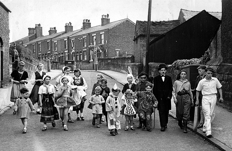
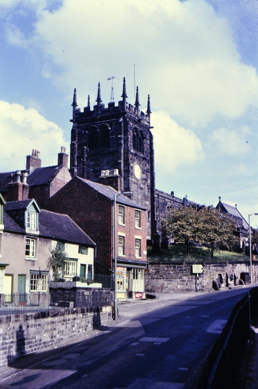
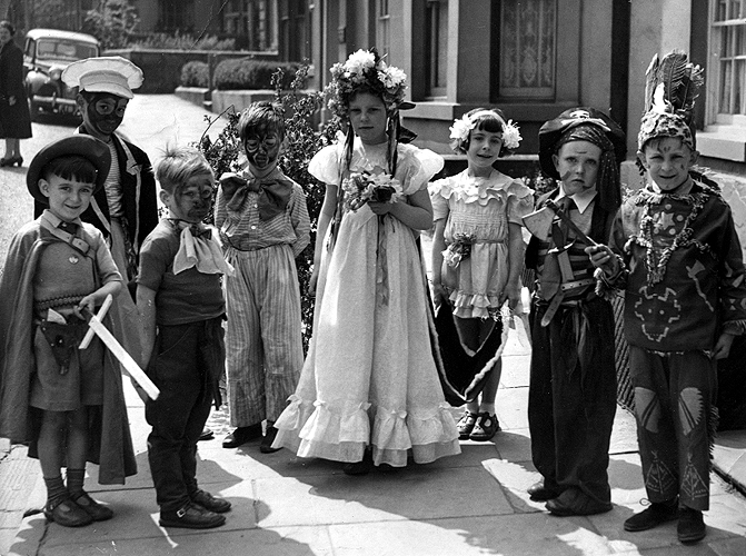
department then as photographer until we moved to Leek 10 years later. In the meantime, my elder brother Edgar had appeared on the scene in July 1946, followed by me a couple of years later. And 13 Moody Street was a ‘tied’ house, opened by the Chronicle’s proprietors, the Head family. In fact, Mr Lionel Head and his wife, who was editor of the Chronicle, lived next door, at No. 15.

13 Moody Street was the end house of a Georgian terrace (Moody Terrace) of eight houses. It still has the same door as six decades ago – but I don’t remember it being red then. And even the same brass door knocker, door knob and letter box.

Just up Moody Terrace lived my best friend, Alan Brennan (at No. 21 or thereabouts); we got into some scrapes. But what I do remember, as the Coronation Day photo shows, is that the various age groups among all the children close-by did interact. One of our favorites was playing in an old air-raid shelter near the local cemetery, or wandering up to the local canal – the Macclesfield Canal – and playing on the swing bridge. Of course, 60 years ago there were few cars. When Steph tried to take the photo of me above, standing at the bottom of Howey Lane, a car came by every few seconds. Moody Street (and surrounding streets) was a very safe place to play in the 1950s.

May Day 1952 (?). I'm on the left and my elder brother Edgar is on the right.

May Day pre-1956. L to R: me; Martin Firth; ?; ?; Patricia Stringer is the May Queen; Deirdre Firth; ?; my elder brother Edgar.

Just round the corner from Moody Street is Priesty Fields, and today this has been joined to a network of public paths connecting Congleton and Astbury, and many other local places. Just off Priesty Fields is The Vale and allotments, with rear access to many of the houses in Moody Terrace.

In the winter, when there was snow on the ground we all used to go tobogganing in Priesty Fields. After six decades, it’s more like ‘Priesty Woods’ there has been so much vegetation grown up.

Part of the town centre is now a traffic-free pedestrian area, in what was Bridge Street. The High Street is still open to traffic. Look at the difference between 1952 and today in these next two photos.

The Congleton Chronicle still occupies the same building in the High Street – I just had to have my photo taken outside. But then, somewhat emboldened, I decided to go inside and introduce myself, with no plan whatsoever as to what I hoped to achieve. Almost immediately the current Chief Photographer, Glyn Boon – who joined the newspaper in 1961 – came in, and once he realized who I was, fetched his camera, and took my photo outside as well. There might be a story in the Chronicle before too long. But then he invited Steph and me to go upstairs and view my dad’s old workroom on the top floor. The very last time I could have been there was in March 1956 – probably earlier. I used to visit him there all the time when I was a little boy. I remembered the stairs as if it were yesterday, but now it’s a quiet building – everything digital now. I remember lots of noise as the printing presses were running, pulleys running everywhere, the smell of ink, Under similar circumstances Health & Safety would have a field day today – just imagine a five year old in such a ‘dangerous’ place. We didn’t think about it then.

It was very special seeing my dad’s work room. And having now been back to Congleton and had quite a good look round, it has triggered many more memories, which I have been sharing on Facebook and through Skype with Martin (now living in central Portugal) and Edgar (who’s been in Canada since 1968).

Little Moreton Hall – an iconic Tudor manor house

The Moreton family began to build Little Moreton Hall in the last years of the reign of Henry VII, and it was completed with various additions in the 17th century. Little Moreton Hall is the epitome of a half-timbered Tudor manor house, its black and white timber-framed construction and intricate patterns typical of the architectural features of that period. It is also surrounded by a moat.

The main entrance to Little Moreton Hall, over the moat. This photo shows the south face of the hall.

The main entrance to Little Moreton Hall over the moat, on the south face.

Located in southeast Cheshire, near the small town of Congleton (where I was born), Little Moreton Hall remained in the same family for more than 400 years until it was given to the National Trust in the 1940s.

I have memories of visiting Little Moreton Hall more than 60 years ago. My family certainly went there in the late 1940s shown in the photo below on the left taken, I believe, in 1947. I was born in 1948, and Ed in 1946; I think he must have been 12-14 months when this was taken, along with my mum and dad, sister Margaret, and eldest brother Martin. The other photo was taken from more or less the same spot just a few days ago.

Much of the hall is open to the public, with the exception of a few rooms on the first floor. There is very little furniture in each of the rooms; you can take in the innate beauty of each of the rooms and their construction. The woodwork is exquisite.

Here is a plan of the ground-floor (drawn by George Ponderevo):

1. Great Hall. 2. Parlour – with painted wall decorations. 5. Withdrawing room. 6. Exhibition room. 7. Chapel. 10. Gatehouse. 11. Bridge. 13. Brewhouse (now toilets). 14/15. Restaurant. 17. Hall porch. 18. Courtyard.

This slideshow requires JavaScript.

There are several rooms open on the first floor.

The first floor-plan (shaded areas not open). 1. Great Hall. 2. Prayer Room - now housing exhibits showing how the hall was constructed. 4. Guests' Hall. 5. Porch Room. 6. Garderobe and privy. 7. Guests' Parlour. 8. Brewhouse Chamber.

The first floor-plan (shaded areas not open). 1. Great Hall. 2. Prayer Room – now housing exhibits showing how the hall was constructed. 4. Guests’ Hall. 5. Porch Room. 6. Garderobe and privy. 7. Guests’ Parlour. 8. Brewhouse Chamber.

This slideshow requires JavaScript.

The crowning glory of the hall is the Long Gallery on the top floor of the south wing. Apparently added at a later date from the original building, the weight of this floor has distorted the walls below, causing them to bulge outwards. Strengthening bars were added in the 19th century. But the unevenness of the walls and floor are easily seen in the slideshow below. The roof is covered on stone tiles, an additional weight that the overall structure could hardly sustain.

This slideshow requires JavaScript.

The gardens are limited by the area of the island on which the hall was built. To the west is a small orchard, and on the north side a formal knot garden that is based on a 17th century design. The water quality of the moat must be quite high as we saw several large koi carp. But in Tudor times that could hardly have been the case, since the privies must have emptied directly into the moat.

This slideshow requires JavaScript.

My first memory of Little Moreton Hall comes from about 1954. I’m not sure if we had made a special visit, or whether my father, as the Chief Photographer of The Congleton Chronicle, had gone there to cover an event. In any case it was my first encounter with Morris dancers. I still vividly remember the Manchester Morris Men dancing outside the hall in front of the bridge across the moat alongside the Manley Morris Men. Once upon a time we had a couple of photographs but I’m not sure if they exist any more. In any case, I did find these photos of them dancing in May 1954, as part of a Mid-Cheshire Tour, and another from May 1953 at Astbury. I’m grateful to the Manchester Morris Men for permission to use these in my blog.

Manley Morris Men

Manley Morris Men: I even remember the dancer on the left with the big grey beard – Leslie Howarth.

A majestic link with the agriculture of medieval England

In the village of Bredon, nestling at the foot of Cotswolds outlier Bredon Hill, and alongside the River Avon (of Shakespeare fame) in southern Worcestershire, is an agricultural treasure from medieval times. From 1350 or thereabouts.

This is the Bredon tithe barn, constructed from golden Cotswolds limestone, with beams from local oak trees, and a stone roof. Oriented north-south, and measuring more than 130 feet long, by about 44 feet wide (and at least 50 feet or more to the apex of the roof) this tithe barn is one of the best remaining examples of its kind – there are others dotted around England’s landscape.

It’s not so easy to find. Although a National Trust (NT) property, there are no detailed directions in the NT Handbook, and in the village of Bredon itself there are no signs to indicate its precise location. We drove through the village and I thought I saw it in the distance, but actually finding a way to it was almost impossible. Eventually, we had to ask the church warden who was working in the churchyard.

Open 7 days a week, it’s possible just to wander around the barn and take in its magnificent woodwork and construction. Occupied by quite a large population of doves, it’s best not to wander round with one’s mouth open when looking up at the roof.

Here’s what is written on one of the National Trust display boards just inside the barn’s open door:
The name Bredon comes from bre, the old British word for a hill. In prehistoric times a fort stood on the hilltop, and the valley below was already being farmed.
   Bredon was an important place by the 8th century, when a minster, or monastery here was granted a great deal of land by the kings of Mercia. Its properties extended as far as Cutsdean in the Cotswolds and Rednal (now on the outskirts of Birmingham) to the north. Gradually this great estate declined and the monastery was reduced until it became no more than a rich parish church. The Bishops of Worcester took over the land and remained lords of Bredon from about 900 until 1559.
   The Bredon barn was built for the Bishops about 1350, at a tragic time in medieval history  The Black Death, the terrible plague that swept across Europe from the East, killed more than a third of the people of England. Half the population of Bredon died, and Bishop Wulstan de Bransford, who probably commissioned the barn here, himself fell victim on 6th August 1349.
   Although the barn at Bredon has traditionally been known as a tithe barn, recent research indicates that it was almost certainly a manorial barn, used for storage of crops from the large and important manor of Bredon.
   Tithe barns were attached to churches, and were used to store tithes (tenths of the produce of the land) paid to parish priests as part of their income. The fact that the Bishops of Worcester were lords of the manor here for more than 600 years probably accounts for the misapprehension. The Bredon barn was well-built and large – 132 feet (40.2 metres) by 44 feet (13.4 metres) – because it was vital to the economy of a large and important estate.

This slideshow requires JavaScript.

The barn was badly damaged by fire in the 1980s, but the National Trust was able to raise the money for its restoration, using locally-sourced oak for the beams, and quarried limestone. It really is a gem, and worth 45 minutes or more of anyone’s time in this lovely riverside village.

Veni, vidi . . . and took lots of photos

Despite dominating ‘England’ for only 400 years or so, the legacy of the Roman invasion and conquest of Britannia – first by Julius Caesar in 55 and 54BC, and then by the Emperor Claudius in AD43 – is quite remarkable. A Roman imprint can be seen in many of our towns and cities, at various fortresses (in the north along Hadrian’s Wall at Vercovicium, or Housesteads Roman Fort and Vindolanda, for example), and in the modern roads, some of which still follow the ancient Roman routes. And there are, of course, other ruins of settlements (such as Wroxeter – Viroconium – in Shropshire) and residences dotted around the countryside. Yesterday, we visited one of the most impressive and significant of the ruins of a private residence, at Chedworth Roman villa in the heart of the Gloucestershire Cotswolds.

Lying just north of Cirencester – Corinium, which was an important Roman town, and linked into three major roads, the Fosse Way (now the A429 to the east), Ermin Street (the A417) to the west and Akeman Street, Chedworth villa was undoubtedly the important and sumptuous residence of a wealthy family – but who? We just don’t know.

Lying hidden for centuries since its apparent abandonment in the late AD300s, the ruins were discovered in 1864, on land belonging to the 3rd Earl of Eldon, a 19th century landowner. The first evidence was some colored stone cubes – tesserae – from buried mosaics. Once uncovered, several beautiful mosaic floors were revealed in all their glory. The archaeology continues today, and while other mosaics continue to be revealed, most of the walls of the remaining ruins have been uncovered.

These are topped by ‘roofs’ to protect them against the elements. But an idea of what the villa must have looked like has been interpreted in a model at the entrance to the villa.

This slideshow requires JavaScript.

Today all that can be seen are the outline structures of the west and north wings, and a small part of the south wing. But what treasures lie inside the west wing. Some of the best mosaics are there, today protected by a National Lottery-funded building in which visitors are able to walk above the mosaic floors on a raised platform. The mosaic on the south side of the west wing covers what is regarded as the dining room. But to the north, there are bathrooms, plunge pools and the like for relaxation.

This slideshow requires JavaScript.

The central heating genius of the Romans is exposed in several locations, but particularly on the north wing, where pillars that supported the floors can still be seen.

Lying in the valley of the River Coln, a source of clean water would have been one of the main reasons for siting the villa here. And in the northwest corner of the villa, in what has been interpreted as a shrine or temple, yesterday’s trickle of water from the spring didn’t seem sufficient to sustain a large community that must have lived at Chedworth all those centuries ago.

The site is also a haven for wildlife, but we didn’t see any of the large edible snails (Helix pomatia) that are found at Chedworth and which were introduced by the Romans. I’ve never heard of these elsewhere but there surely must be other populations around the country. At Chedworth they’ve survived – even as a local population – for two millennia.

No doubt the continuing archaeology will eventually tell us more about the life and times of Chedworth, one of fifty or more villas in the Cotswolds. Another – but important – link in our rich history.

Dudmaston – in the same family for more than 800 years

The same family – more or less. Dudmaston Hall has come down to the present residents (I don’t think ‘owners’ is the right term as the National Trust is involved in looking after property) through various familial inheritance twists and turns, not by direct ancestry. Landed gentry but not aristocrats.

Lying in the Severn Valley, a few miles south of Bridgnorth in Shropshire (but close to Worcestershire and Staffordshire county boundaries), Dudmaston Hall (well, the present building at least) dates from the late 17th century.


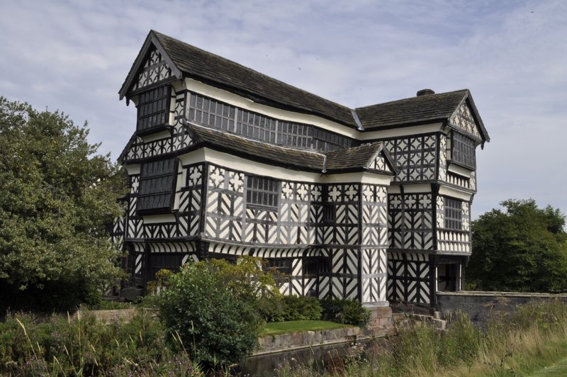
In many ways the house itself is quite modest. The ground floor entrance hall, library and oak study are open to the public. Access to the first floor is up a beautiful cantilevered staircase. Several bedrooms can be viewed – some of them still used as guest bedrooms! As the house is still lived in, photography is not permitted inside the house.

From 1966 until their deaths in the late 1990s, Dudmaston Hall was home to Sir George and Lady  Rachel Labouchere (she had inherited the hall from her uncle Capt. Geoffrey Wolchyre-Whitmore, the family that had lived at Dudmaston for several generations). Sir George served in the diplomatic service during and after the Second World War, and was HM Ambassador in Spain from 1960-1966. He was also an avid collector of modern art (including many by Spanish artists), assembling – it’s reported – one the most important private collections in the country. Many of the best pieces are still displayed at Dudmaston today. I’m afraid I’m not really enthusiastic about modern art, but there was one bronze sculpture that really did take my fancy. Out of my budget range, though.

Lady Rachel Labouchere

Lady Rachel Labouchere

Lady Rachel was a collector of botanical paintings, and many of those she collected are also on display, and of particular interest to Steph and me because of our botany backgrounds.

The gardens at Dudmaston are nothing to write home about, but the estate and park are extensive with opportunities for long walks – which we took full advantage of. Starting from the car park we headed towards the Big Pool that you can see on the map below (click on it for a larger image), over the Rustic Bridge, round the Dingle, across the dam, and following the path to the River Severn. Coming out of the woods on to a west-facing slope above the river, we could see the track of the Severn Valley Railway (a heritage line) on the other side. It would have been a great spot to watch the steam trains. But none came by, but once we’d headed back along the lake, we did hear a couple of locomotives whistling in the distance.

The lake has a high dam at the southern end, and is a haven for a large flock of Canada and greylag geese, that were swimming about in ‘family’ groups and happily honking to each other.

While not the seat of a distinguished aristocratic family, Dudmaston Hall does have some important links with Britain’s industrial heritage. Lady Rachel was descended from the Darby family of Coalbrookdale (said to be the birthplace of the Industrial Revolution, less than 15 miles north of Dudmaston), where Abraham Darby developed iron smelting in the first decade of the 18th century and where, at Ironbridge, the world’s first bridge constructed from iron was built across the River Severn in 1779 (by Darby’s grandson, Abraham Darby III), using the same design principles as if it had been made from wood.

From: http://en.wikipedia.org/wiki/File:IronbridgeCharles Babbage, father of the computer who designed a mechanical Difference Machine in the early 19th century, was the brother-in-law of the Wolchyre-Whitmore owner of Dudmaston at that time. Babbage spent considerable periods at the hall. He also invented and installed the hall’s central heating system, and several of the metal vents are on display. 

So while the visit to Dudmaston was, in some respects, a little disappointing, it was nice to get out and about, and enjoy a late summer day in the fresh air. Fortunately the journey to Dudmaston took little more than 30 minutes, being only 18 miles or so to the northwest of Bromsgrove.


On 24 June 2020, we made a farewell visit to Dudmaston. As more National Trust properties begin to open, we are taking the opportunity to grab tickets as and when we can. Last week we had a lovely walk around the park at Hanbury Hall.

It was the hottest day of the year to date yesterday, but that didn’t deter us from heading to Dudmaston, and attempting a walk around the pool. In fact, when we arrived there, right on time at 13:30, we discovered that the NT had implemented a one-way system around the park, so once we’d started there was no turning back. We followed the route (shown by a red dotted line on the map below) through The Dingle, across the dam, and round the Big Pool back to the garden in front of the house.

Here is a link to a photo album of yesterday’s visit.


Three days, three houses . . .

During our trip to the northeast a couple of weeks ago, we visited three National Trust properties over three days. They all had one feature in common: until quite recently they were still occupied by their owners.

In Northumberland, the two houses were: Seaton Delaval Hall, just north of Whitley Bay, about a mile inland from the North Sea Coast (map); and Wallington House and Gardens (map), home to generations of the Blackett and Trevelyan families for generations, about 25 miles northwest of Newcastle. In North Yorkshire, just south of Helmsley in the North York Moors lies Nunnington Hall (map), which we visited on the journey home.

Seaton Delaval Hall
This impressive property was designed in 1718 by Sir John Vanbrugh (who also designed Blenheim Palace and Castle Howard) for the Delaval family who had occupied estates in the area since the time of the Norman Conquest in the 11th century. It comprises a Central Hall and West and East Wings (which houses the large stables). The Central Hall was destroyed in a fire in 1822, although a number of features did survive. The West Wing (and the extensive cellars) originally housed the servants, but in the 20th century became the residence of the owner. Some restoration has taken place, and the Parterre Garden was designed in the 1950s. Although Seaton Delaval will never again reach its former glory, its outward appearance speaks volumes for what it must have been like.

This slideshow requires JavaScript.

Wallington House and Gardens
The hall dates from the 17th century, but had extensive modifications in the Palladian style in the 18th. Two aspects particularly impressed me: it definitely had the feel of a family home; and the walled garden, about 15 minutes walk away from the house, in among the woods, is perhaps one of the nicest gardens I have visited. The entrance hall has bright murals showing many different aspects of the history of Northumbria, and the house is full of beautiful treasures. Wallington is definitely worth a visit for so many reasons.

This slideshow requires JavaScript.

Nunnington Hall
Alongside the River Rye, parts of the house date from the Tudor period, but over the centuries it was remodeled. There are signs of its occupation by Parliamentary forces during the English Civil Wars of the 1640s. The gardens are not extensive, but quite attractive.

This slideshow requires JavaScript.

Leek – Queen of the Moorlands (updated 2018-11-05)

April 1956. Did my world fall apart? I probably thought so at the time.

We moved from Congleton in Cheshire (where I was born seven years earlier) to the small market town of Leek in north Staffordshire. Less than 12 miles away, but it could have been another planet for all I was concerned.

New town, new home, new school, and new friends.

When I say ‘small market town’ I always was under the impression that Leek had a population of about 20,000 when we moved there in 1956. So I was quite surprised to note in the 2001 census that the population was a smidgen under 19,000. It seems the population has changed very little over the past century.

I’m not sure that I could say that Leek is a picturesque town, but it’s certainly a very interesting one, with some remarkable features and history (the link gives a pretty comprehensive account). And it’s surrounded by some of the most glorious landscapes in the country, the Staffordshire moorlands on the southern edge of the Peak District (the UK’s first national park). Although I was not born there, and actually only lived there for a little over a decade before moving away to university (and moving on) I still think of Leek as my home-town – and proudly so!

In the 1960s panorama below, taken from the top of Ladderedge (on the southwest of the town, besides the main road linking Leek with Stoke-on-Trent – the Potteries) looking towards the northeast, you can see many of the distinctive features of the Leek skyline.

1-13 Leek

Just to left of center is the square tower of the 13th century Anglican Church of St Edward the Confessor (although there is some evidence for a pre-Norman church in the vicinity), and to the right of center, the tall spire of the Roman Catholic church, St Mary’s (which we attended), built in 1887, although there had been earlier churches.

Church of St Edward the Confessor

To the right of St Mary’s spire is the white clock tower of Leek’s impressive war memorial, the Nicholson War Memorial, commonly known as The Monument (at the eastern end of the main shopping Derby Street), and to the right of that another Anglican church, St Luke’s, with a square tower and a small spire to one side.

The Nicholson War Memorial (the Monument), photographed in April 2012. The roundabout has now disappeared – a great local controversy – as part of road ‘improvements’ to ease the flow of traffic. The video below shows its dedication in 1925.

And in the middle of the panorama rises the impressive green copper dome (no longer green) of the Nicholson Institute, housing the public library and art gallery (including a facsimile of the Bayeux Tapestry) and (in the past at least when I was growing up) a celebration of much of Leek’s wealth that was built on the silk weaving industry. Indeed, textile manufacturing and dyeing were among the main industrial endeavours in Leek, and quite a few of the mills and their chimneys can be seen on the Leek skyline. In the mid-60s a couple of these were destroyed by fire within the space of just one week – very dramatic happenings in a small town. William Morris, a prominent member of the Arts and Crafts Movement, may have resided in Leek for several years.

The central area of Leek is bounded by five streets: St Edward Street on the west, Stockwell Street on the north, Brook Street/Hayward Street on the south, and Ball Haye Street on the east. And these are through routes connecting Leek with Buxton to the northeast, Macclesfield to the north-west, the Potteries to the southwest, and Ashbourne to the east.


We lived in a couple of properties in St Edward Street where my father established his photographic retail business between our arrival in Leek in 1956 until 1962.

Then my father was able to purchase a prime site in the Market Place, which he kept until his retirement in 1976. I’ve recently discovered that 19 Market Place is now a shop selling home-made jewellery – Little Gem. That’s quite interesting since my wife’s main hobby is making bead jewellery. We must visit next time we are in Leek. But I digress . . .

Leek was granted a charter to hold a market on Wednesdays during the reign of King John at the beginning of the 13th century. And that market thrives today. In the valley of the River Churnet, and on the north-west of the town lie the rather depleted ruins of a Cistercian abbey, Dieulacres; many of the stones were used in local building after Henry VIII’s men had done their business, and particularly in the Abbey Inn that is found close by.

Leek was connected to the growing canal system in 1801, with a branch of the Caldon Canal. It closed in the mid-1940s, and was eventually filled in (now part of an industrial estate on the southeast side of the town). Famous 18th century canal engineer James Brindley lived in Leek for many years. Until the 1960s Leek was served with rail connections, but after these ended, the station was demolished in 1973. The last steam trains from Leek in 1965 are shown in the video below.

I read recently of plans to try and reopen the mothballed railway link between Leek and Stoke. The web site has some stunning photos of steam locomotives near Cauldon Lowe.

Close by the Monument is the bus station, opened in the 60s on the site of the former cattle market (that moved afterwards close to the site of the old railway station. Thanks to my old friend Geoff Sharratt for sharing these two photos with me.

We never talked politics at home. I suspect my parents voted Conservative, but I do not know for sure. When we lived in Congleton my father was elected to the local council – Congleton was a borough with a mayor. Not long after we moved to Leek my father sought election to the Leek Urban District Council – as an Independent since he strongly believed that national political affiliations had little or no place in local government. In 1968 he became Chairman of the Leek Urban District Council.

In the 1950s and 60s as I was growing up in Leek the annual Club Day, a 200 year-old tradition, held in mid-July was (and still is, apparently) a very important event in the town’s calendar. Held on a Saturday afternoon, it brought together churches and Sunday schools of all denominations in an ecumenical celebration, held in the Market Place. It was a riot of colour and best outfits, banners and bands, with the children and their parents and friends processing from the individual churches to the Market Place, and afterwards around the town.

This slideshow requires JavaScript.

Today it seems that Club Day in Leek is rather a different celebration altogether. My elder brother Ed and I took part for a number of years with the St Mary’s 5th Leek Cub (cub scout) Pack. Here we are in our Cub uniforms.

Me with my brother Ed (r) in our Cub uniforms in the late 1950s.

Me with my brother Ed (r) in our Cub uniforms in the late 1950s.

After my parents retired in 1976 they took up residence in a first floor apartment in Greystones, a 17th century town house on Stockwell Street, just in front of the Nicholson Institute. After my mother (and the lady on the ground floor) moved out in the mid-80s, the property became a tea room.

Greystones, with the Nicholson Institute behind.

Greystones, with the Nicholson Institute behind.

But in many ways it’s the location of Leek that is one of its best assets, nestling as it does in the shadow of the Staffordshire Moorlands, with close access to the Peak District National Park, and particularly the Roaches, Dovedale, and the Manifold Valley to mention just a few special places, and the famous ‘double sunset‘ that figures in the old coat of arms (two suns).

Here’s a video I found recently on YouTube (2014-04-25) about the Staffordshire Peak District – all within a 10 mile or so radius of Leek:

I visit Leek rather rarely now, but when I do walk around the town, and look at how it has changed over the decades, my mind fills with good memories of a happy childhood. It was good growing up in Leek. And it seems that many around the world also hold fond memories of Leek, as comments on the Visitors’ Book at Leekonline show.

And finally, here are some recent photos of Leek that I have put together in a short video.

The majesty of Kedleston Hall

Kedleston Hall. An impressive Palladian mansion in the Derbyshire countryside, just a few miles to the west of Derby city centre. Kedleston has been the seat of the Curzon family for generations, almost 1,000 years! The Curzons accompanied William the Conqueror on his 1066 jaunt to England, and stayed on, accruing vast estates in the process. What’s interesting from a personal point of view is that my grandmother’s family (BULL) come from the village of Hollington (and neighbouring villages) only a few miles further west from Kedleston. I guess over the centuries their lives must have been influenced, one way or the other, by the Curzons.

The present builing was designed by Robert Adam, relatively unknown at the time he received the commission from Sir Nathaniel Curzon. Kedleston Hall remains one of the best examples of Adams’ designs still standing.

Standing in about 800 acres of parkland, Kedleston is approached along a winding road, that crosses a bridge over a weir in the man-made lake.

It was never intended, apparently as a family home, but as a venue for Lord Curzon to show off all his accumulated art.

01-20130708001 Kedleston Hall

The east wing (on the left in the photo above) did house the family quarters, while the servants lived and worked in the west wing. The Grand Salon in the central structure was meant for entertaining and displaying the works of art. The entrance today is through the ground floor on the north, and entering the main hall on the first floor the size and height of the entrance hall are very impressive with marble columns either side. There are rooms leading off on both sides, and it’s possible to make a circular tour of the rooms, passing through a music room, a sitting room, a library, the dining room, and a state bedroom, among others.

This slideshow requires JavaScript.

Alongside the hall is the small All Saints Church, no longer used for worship, but the mortal remains of many of the Curzon family are buried there. Under floor near the main altar are two figures of the Fifth Lord Curzon of Kedleston and his wife, dated 1275.

While this house does not have impressive gardens through which to wander, the large parkland does offer the visitor an ample opportunity for some pleasant exercise in the Derbyshire countryside.

And on the ground floor is an interesting museum of Indian artifacts – weapons, jewellery, ornaments, silverware, and costumes – from the time of George Nathaniel Curzon who was Viceroy of India from 1899-1905.

Capes, coves . . . and endless beaches – the beauty of Oregon

From Cape Lookout, looking north to Cape Mears

From Cape Lookout, looking north to Oceanside, and Cape Mears beyond

We hadn’t planned on a beach vacation in Oregon this year, but Steph and I had mulled over the idea of a road trip from San Francisco to Seattle, and returning to the Twin Cities from there by train. Just a whim of mine.

For the past three years we’ve tried to make a ‘side trip’ away from St Paul when we travel to the USA to visit Hannah and family. In 2011, it was ‘canyon country‘; last year it was the Minnesota Riviera. Then Hannah told us about a beach house on the Oregon coast that was available for rent, and that was it: vacation agreed, and planned. Well, not quite. In addition to the week at the beach, Steph and I traveled south to Crater Lake in Oregon, and then on into northern California to see the majestic coastal redwoods, following US101 most of the way. This is the route we took.

So on 8 June we boarded our 3½ hour Delta flight from MSP to Portland, and then it was a 110 mile drive (a little under two hours) to the coast. Our beach house was just outside and to the north of the coastal community of Oceanside (just south of Cape Mears), and about nine miles west of the nearest large town Tillamook, the cheese capital of Oregon. That in itself was an interesting trip, passing through the Coastal Range, a rather winding road, and suddenly emerging into this coastal plain that is Tillamook.

It didn’t take long to determine this was a dairy farming center; just a quick sniff and the presence of lots and lots of cows could be detected in the air.

I’d originally booked a standard saloon rental with Budget, but agreed an upgrade to an SUV – a Chevy Captiva. Nice vehicle, spanking new, only nine miles on the clock. But after a major system failure a couple of days later (a known Chevrolet problem for a number of years – just Google ‘Chevrolet’ and ‘Reduced engine power’) Budget replaced it with a Ford Escape, and had it delivered to Oceanside from Portland.

Our beach house had a fabulous view out over the Pacific Ocean. And while we thought this was pretty spectacular, it wasn’t necessary to travel far to see some more pretty impressive landscapes. US101 hugs much of the Oregon coast, snaking around jagged headlands, soaring above others before plunging to stretches of beach that seem to stretch into the distance forever. In places this road seems no wider than a country lane, occasionally becomes a divided highway, or at least two lanes for the uphill traffic. Sandwiched between the cliff edge and the mountains, surrounded by trees, with the occasional glimpse of the coast far below, or at the many viewpoints, this has to be one of the most spectacular road trips on the west coast.

The wind blows constantly, the waves roll in incessantly, and the eye is drawn to the horizon – next stop Japan or the Philippines (where we lived for 19 years). While it was mostly bright and sunny during our stay in Oregon, there were times when the sea mists rolled in, giving the landscapes a rather mysterious ambience. We didn’t see any whales, although the coast off Cape Mears is a well-known whale watching spot at certain times of the year. But there were plenty of seabirds, and some sea lions.