I rarely read fiction. I’d much rather get my nose into some interesting historical tome. But as I’ve found from experience over the past years, not all historians are adept at stringing an interesting narrative together.
Our public library here in Bromsgrove has quite a large history section, but the majority of the books are about WW1 and WW2. I did begin reading some of these, but frankly one or two made me quite depressed after reading one commentary after another about the barbarity of 20th century warfare.
However, when I was looking for a book last week, there was nothing in the history section that attracted my attention, and I’d already read those that would.
So I was drawn to the fiction shelves, and suddenly had the bright idea to check out if there were any books by acclaimed Scottish author Peter May. Now I have to make a confession here. Until my recent trip to the Outer Hebrides I’d never heard of Peter May (although I think my wife Steph had read a couple of his books). Anyway, to cut a long story short (excuse the pun), I found a couple of May’s books on one of the lower shelves and decided to take them out on loan.
I finished his The Lewis Man (second of his Lewis Trilogy, published in 2012) in a couple of days, and have just started Runaway that was published earlier this year. I don’t intend to write a review of The Lewis Man here. It was an easy read, the narrative guided you through effortlessly, and there was an interesting twist to events at the end.
But what brought the book alive, for me at least, was the fact that I had just completed a road trip that took me from the north of the Isle of Lewis to the southern tip of Eriskay—many of the places and landscapes described in May’s book. So I could really imagine myself there as he describes how events unfold, and in particular how the weather inflicted on the Western Isles has determined where and how humans settled and adapted to this challenging environment.
In collaboration with Lewis photographer David Wilson, May has also published an anthology of prose and images titled simply Hebrides. Now I can’t claim that my images compare in the slightest with the beauty of Wilson’s. I had just the one opportunity to catch the moment during a few days whereas he’s a resident. But here are just a few of mine that came to mind as I absorbed myself in The Lewis Man.
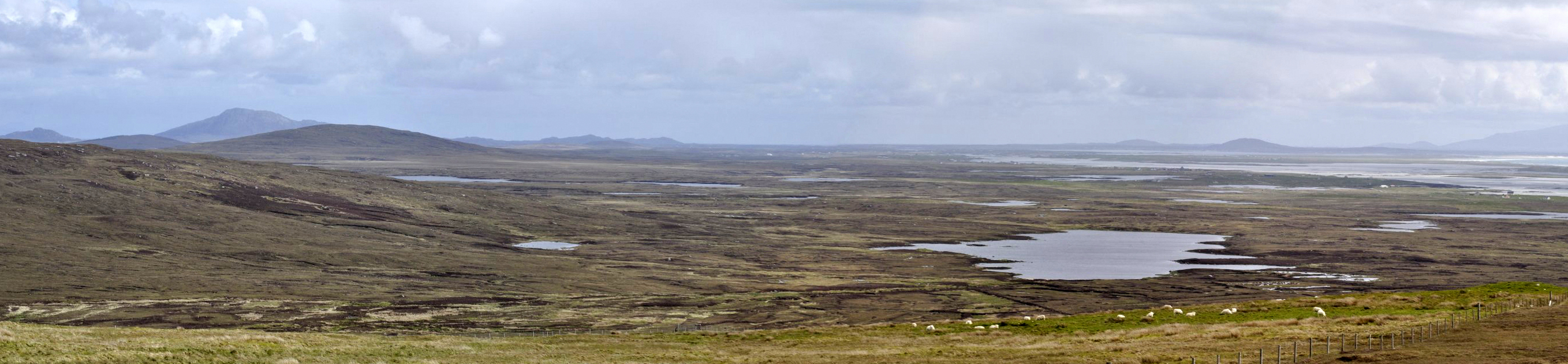
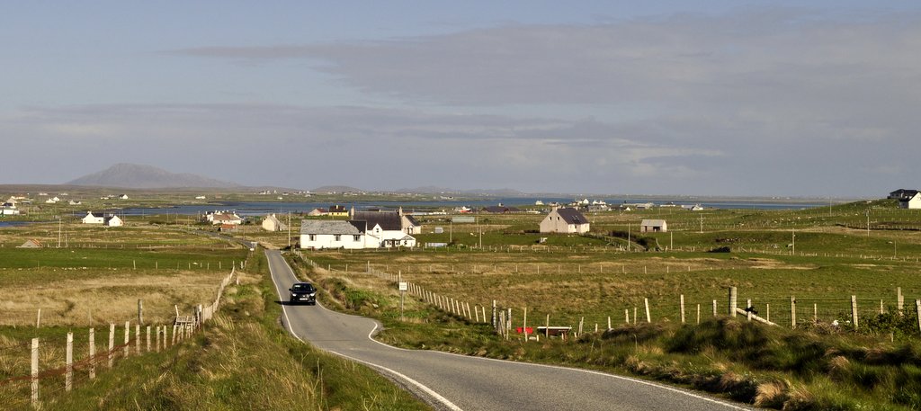
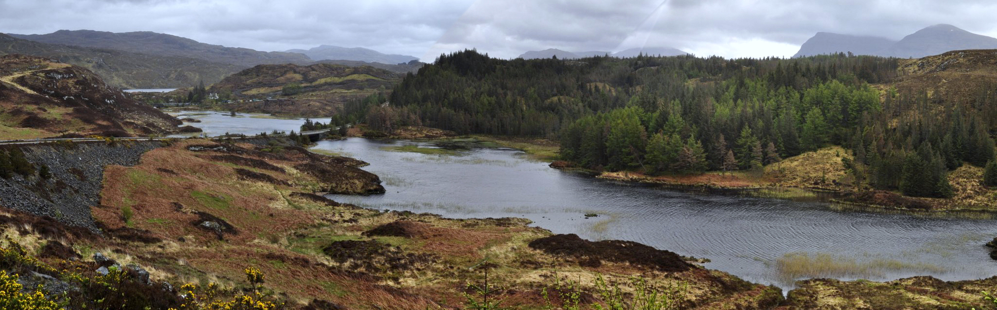
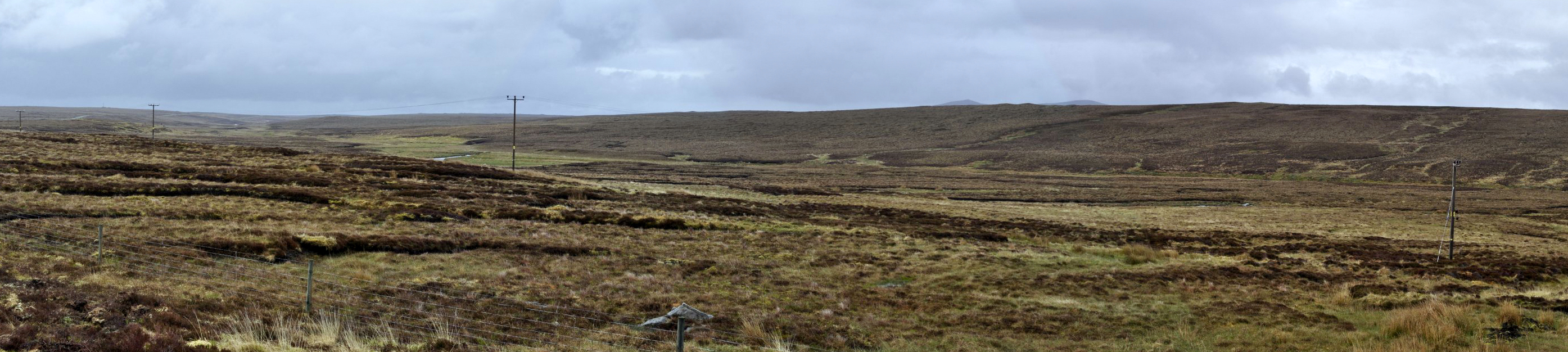
The moor between Stornaway and Barvas, Lewis
The Butt of Lewis
The Butt of Lewis lighthouse
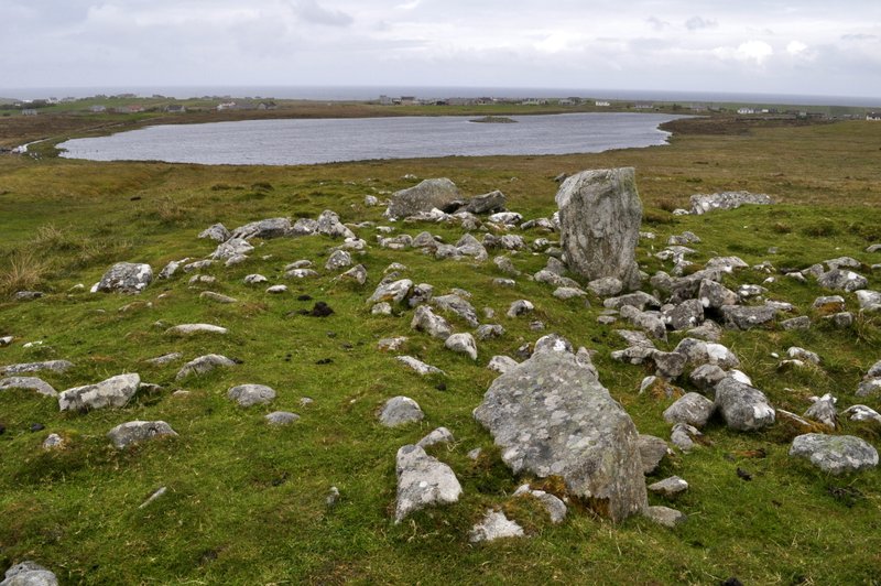
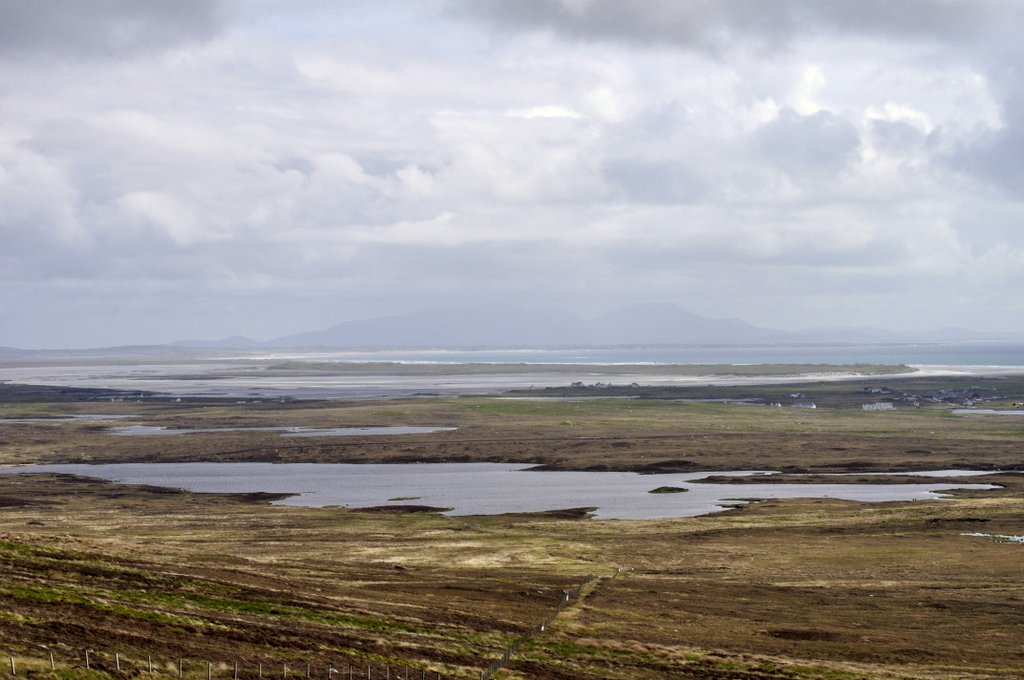
Looking west towards Loch an Duin, Siadar and the Atlantic, from Steinacleit, Lewis
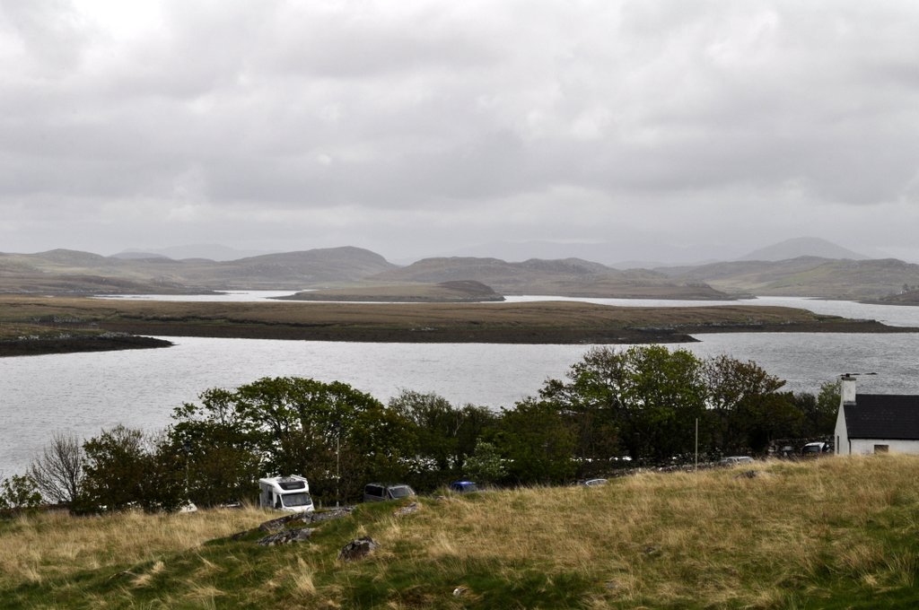
Callanish Standing Stones, Lewis
Looking southwest from the Callanish Standing Stones, Lewis
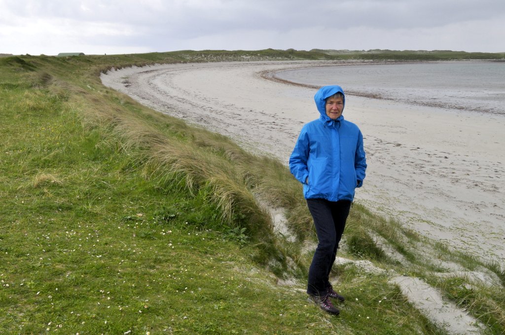
The beach at Bostadh, Lewis
Loch Seaforth, North Harris
Near Seilebost, South Harris
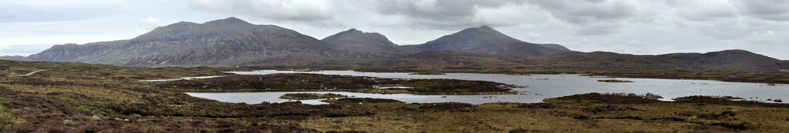
The mountains of South Harris
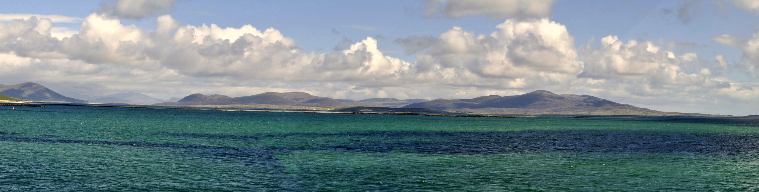
Crossing the Sound of Harris frpm Leverburgh, South Harris to Berneray
Crossing the Sound of Harris
Lochportain, North Uist
The machair at Mhalacleit, North Uist
Hougharry, North Uist
Hougharry, North Uist – returning after 48 years
On the A865 towards Clachan from Balranald, North Uist
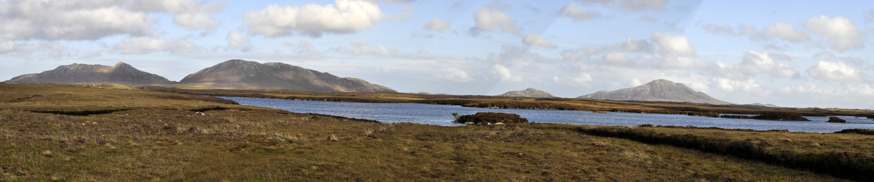
A panorama over North Uist, looking south from South Clettraval
Looking north from the Benbecula-South Uist causeway
Derelict house on the road to Lochskipport, South Uist
The harbour at Lochboisdale, South Uist
The causeway connecting South Uist and Eriskay
First beach of silvery sand after crossing the causeway on to Eriskay from South Uist
The silvery sands of Eriskay, looking towards the ferry terminal and Barra to the southwest
St Michael’s Church on Eriskay
The boat under the altar, St Michael’s Church, Eriskay
Morecambe and Wise? Ant and Dec? Lewis and Harris? Not another comedy or presenter duo, surely?
Not by any means. Lewis and Harris is the largest island of the Outer Hebrides. Often referred to as the Isle of Lewis and Isle of Harris, Lewis occupies the northern half of the island, and North and South Harris the southern end. South Harris is almost an island, and there is only a tiny isthmus at Tarbert connecting North and South.
Our journey around the island took one and a half days, to the northern-most tip at the Butt of Lewis, to Rodel on the southern tip of South Harris. We set out from Stornaway to the Butt of Lewis under heavy grey skies, that grew darker and darker the further north we traveled. It was blowing a real gale by the time we reached the Butt of Lewis, the rain was horizontal, and I did wonder whether we’d get chance to see anything at all. But, as on most days of our holiday, the weather improved at the right moment, and it stopped raining. The wind did not drop, however.
Blowing a gale at the Butt of Lewis.
Butt of Lewis panorama – next stop North America!
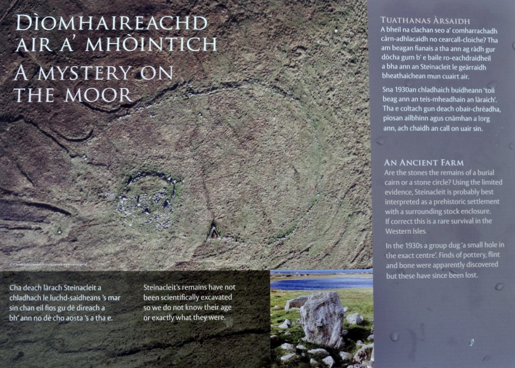
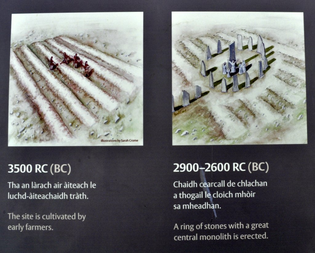
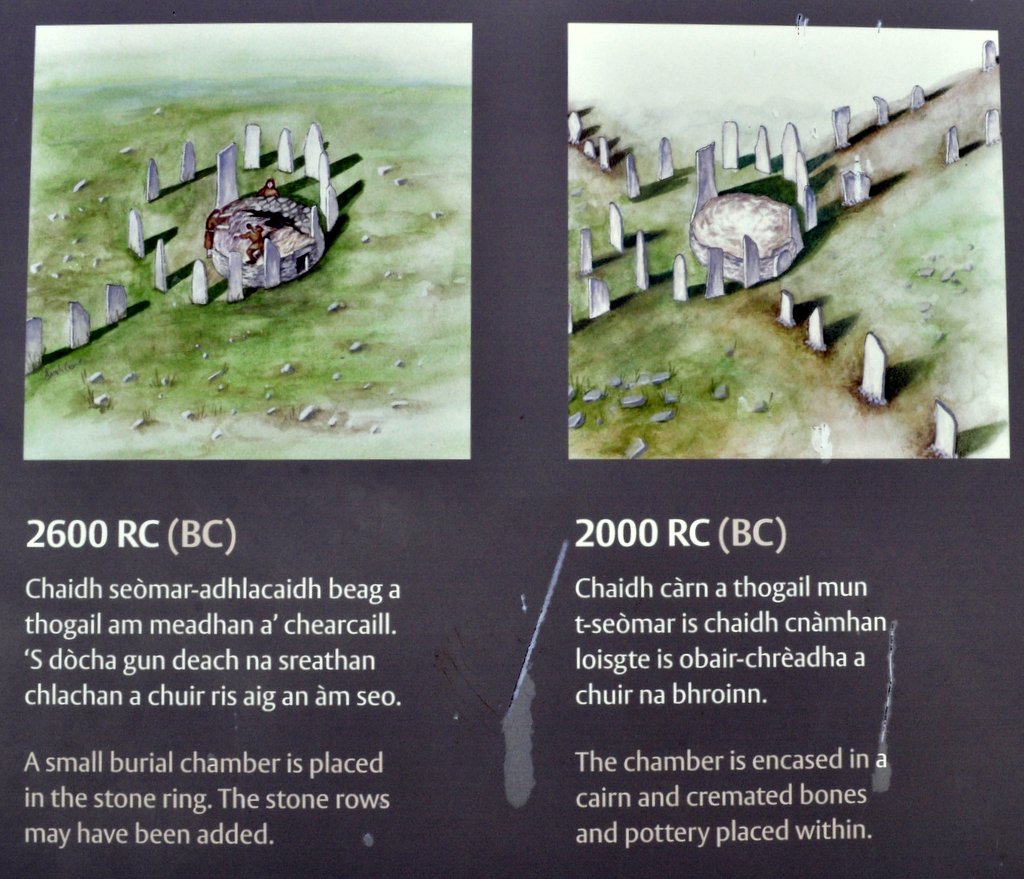
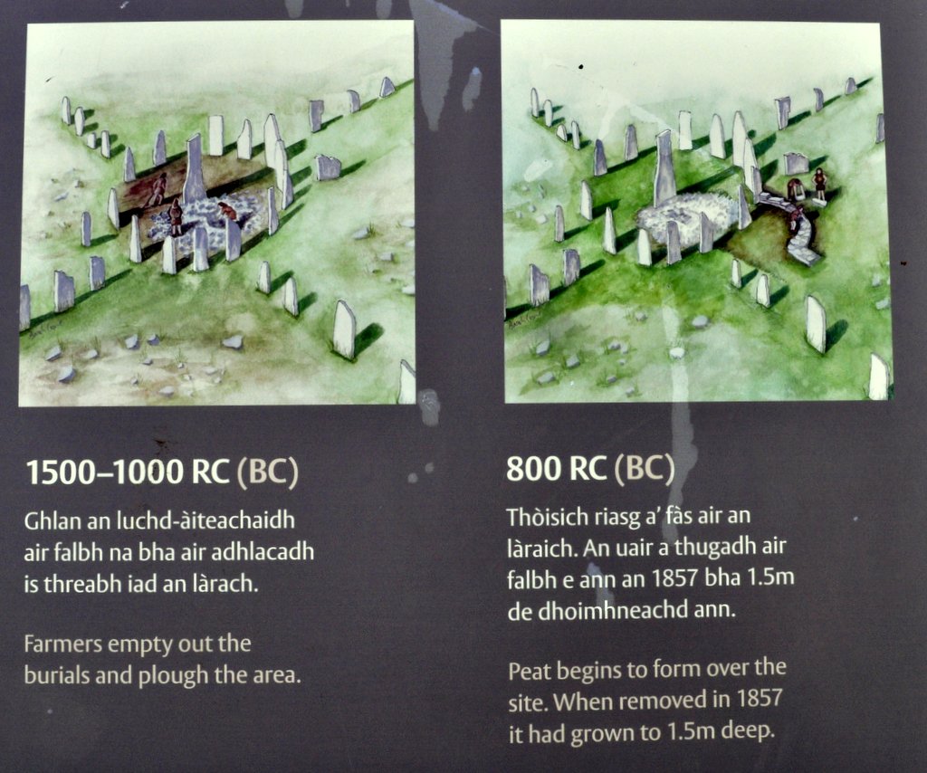
On our way to the Butt of Lewis we had seen a signpost for a stone circle known as Steinacleit, near the township of Upper Shader. So we decided to stop there once we had begun to make our way south.
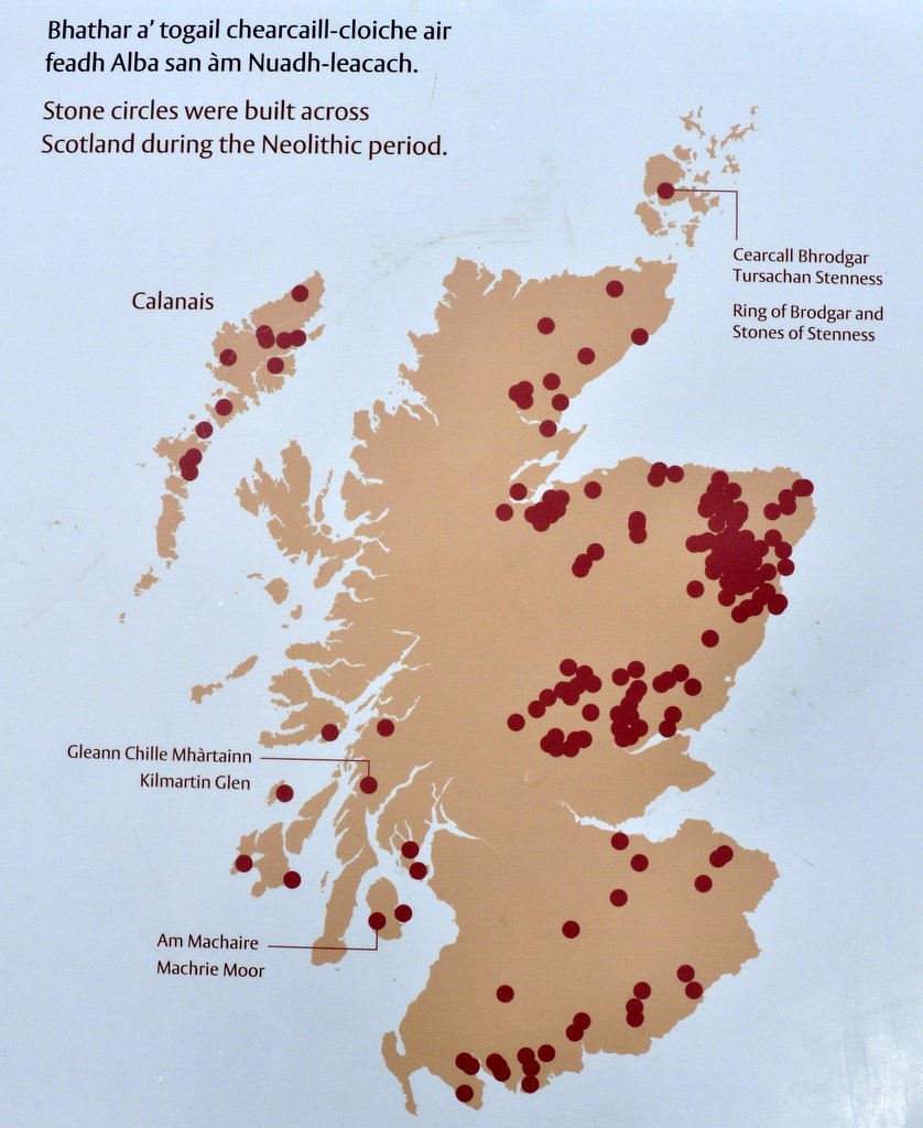
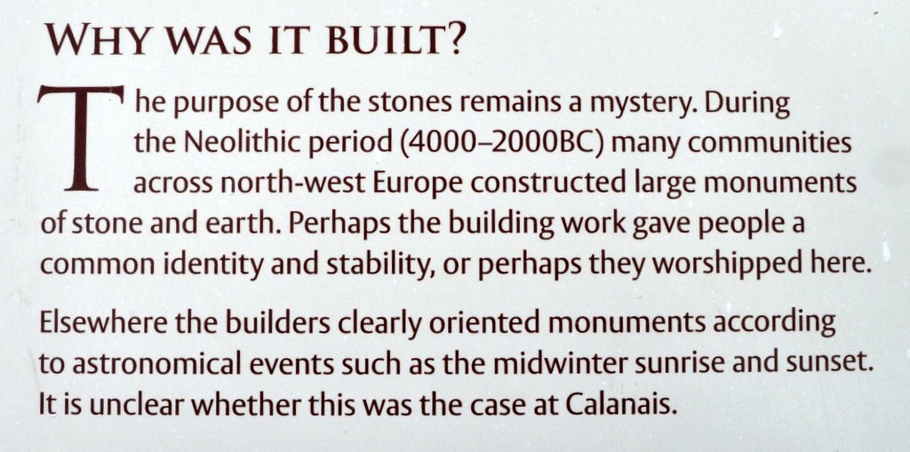
At first there didn’t appear to be much to see on the ground. But once we had our bearings, it was possible to discern the remains of an outer circle of stones (the remains of an enclosure, perhaps) surrounding a central cairn. The site has not been excavated scientifically, so not much is known about who built the circle and when. What artefacts that were found in the 19th century have been lost.
Looking west towards Loch an Duin, Siadar and the Atlantic, from Steinacleit, Lewis
Next stop on our Lewis itinerary were the Standing Stones at Callanish—a truly remarkable, mystical yet peaceful location, erected on a low hills overlooking mountains and lochs to the southwest.
Calanish Stones, Lewis
Callanish Standing Stones, Lewis
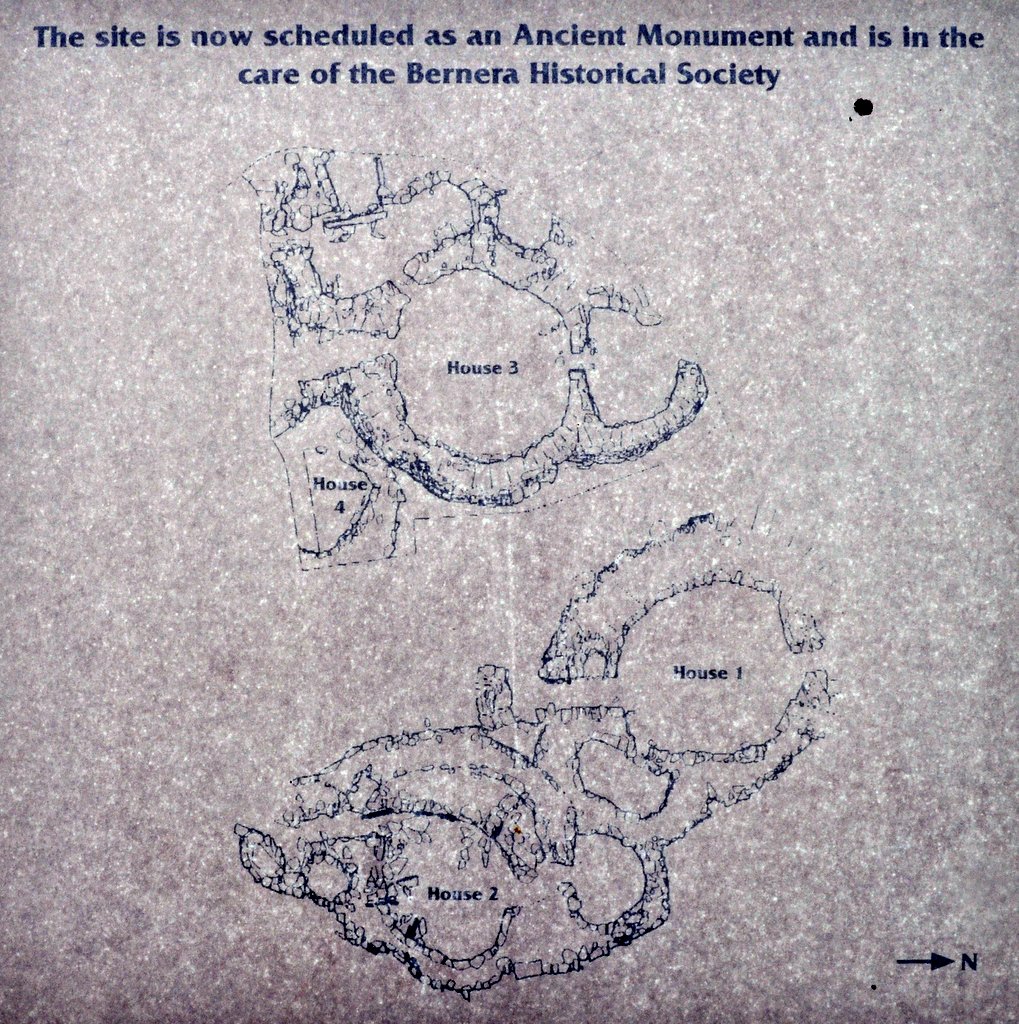
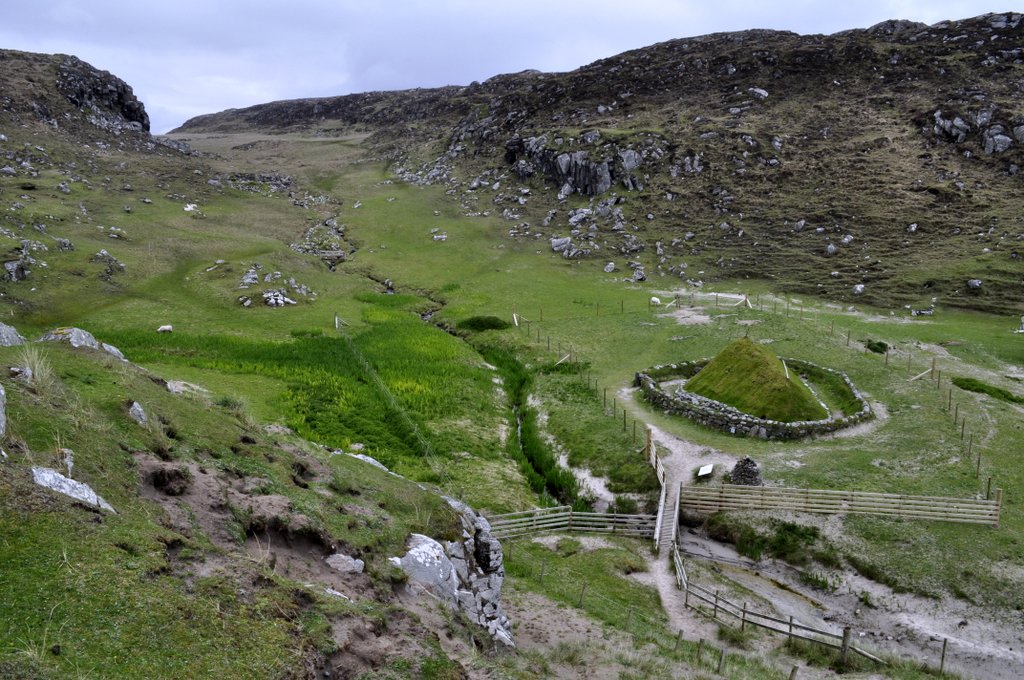
Our third archaeological site was at Bostadh on the north coast of Great Bernera, where an Iron Age village was discovered, and one of the houses reconstructed.
Then we headed further south, into Harris and on to our B&B a few miles south of Tarbert, at Drinisiadar.
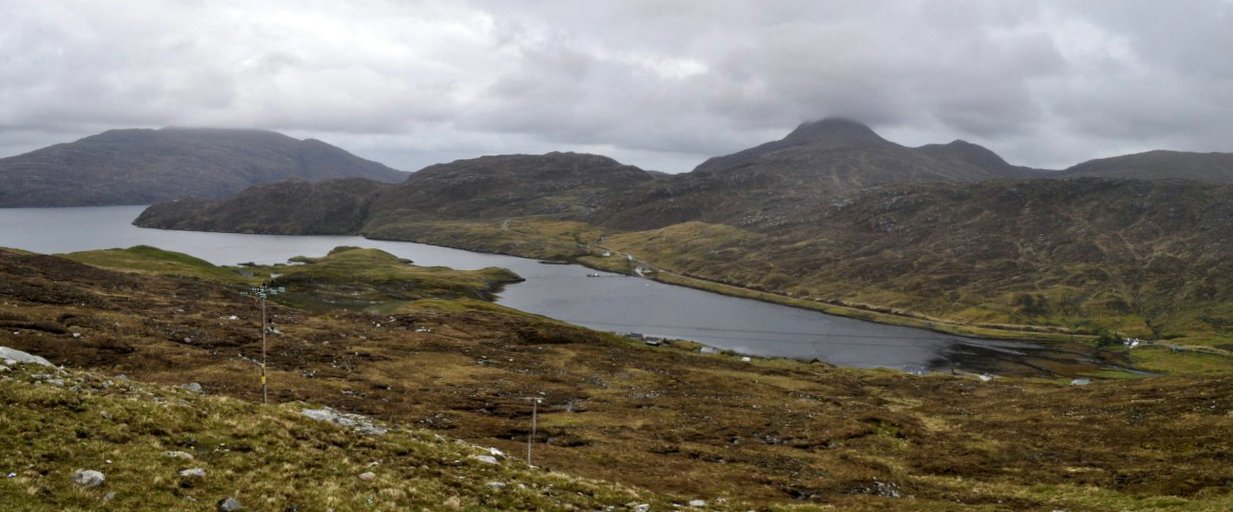
Loch Seaforth.
The hills of North Harris.
Evening sunshine across the loch in front of our B&B.
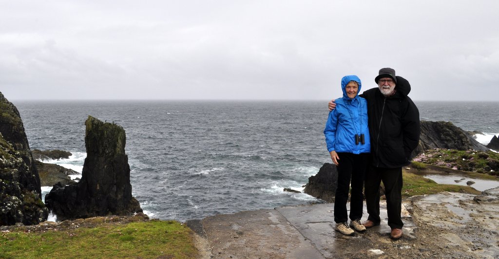
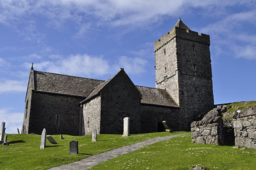
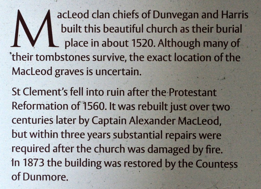
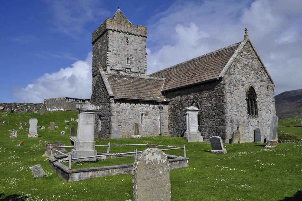
The following morning, we had a couple of hours free before we had to take the Sound of Harris ferry from Leverburgh to Berneray (and the Uists). So we had a leisurely drive along the coast of South Harris, ending up at Rodel—the end of the road, where’s there is a beautiful little sixteenth century church of the MacLeod clan, St Clement’s (apparently dedicated to Pope Clement I).
Near Seilebost, South Harris
The mountains of South Harris
St Clement’s Church, Rodel, South Harris.
The nave.
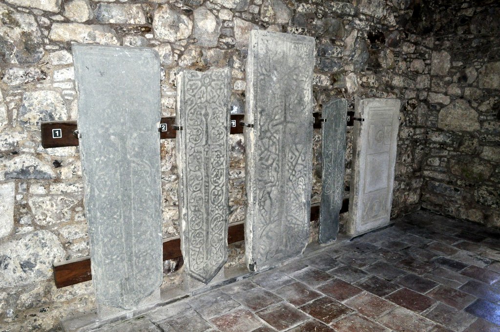
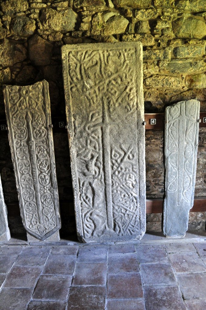
A side chapel with the sword stones.
One of the finest tombs in Scotland, of Alasdair Crotach MacLeod, 8th Clan Chief of the MacLeods.
Last Monday was the last day of our holiday in Scotland. We’d reached Lockerbie in Dumfries and Galloway on Sunday night, and just had the journey down the A74(M) and M6 to reach home.
Two hours is about as much as I can take driving on the motorway before I need to take a break. And we had discovered that there was a National Trust property, Rufford Old Hall, in Lancashire just south of Preston, about equidistant between Lockerbie and home. The ideal place to stretch our legs, have a bite to eat, and enjoy another of the Trust’s delights. In fact, it seems that many holidaymakers have exactly the same idea. One of the volunteers told me that Monday is usually a busy day, with many visitors breaking their journey north or south at the hall. Rufford Old Hall is very convenient to the M6, just a handful of miles west of Junction 27.
Formerly the home of the Hesketh family, Rufford Old Hall (is there a new one?) has two main wings: an original timber-framed Tudor one built in 1530 for Sir Robert Hesketh, oriented east-west, that may have once also had another wing on the west side (there are two ‘external’ doors on the west wall) but this no longer exists; and a later seventeenth century brick wing, north-south. The main entrance opens into what was once the kitchen, but that was moved to another location in the same wing at a later date.
Rufford Old Hall is an L-shaped building.
The main entrance in the seventeenth century wing.
The bow window of the Great Hall.
On the south side, there is a dining room and an upstairs gallery in this bow-fronted part of the building.
The exterior of the Great Hall on the south side. The skylight was added in the 19th century.
The crowning glory of course is the Tudor wing, which consists primarily of the Great Hall with its magnificent bow window and small section of original Tudor stained glass. The roof of the Great Hall is a wonder to behold in timber architecture and construction. There is also a moveable screen just inside the hall. Photography is permitted only inside the Great Hall as the National Trust does not own all the items on display elsewhere throughout the property.
Bow window in the Great Hall with original Tudor stained glass.
The east end of the Great Hall, with the large moveable screen.
The screen from the floor above.
The impressive roof and ceiling.
The skylight was added during the Victorian era.
A billiards table was positioned beneath the skylight that allowed more light directly below.
On the west end of the Great Hall, these two doors now open to the exterior, but may once have provided access to another wing that no longer exists.
There is a small formal garden, with renowned squirrel topiaries, and walks through orchards, woodland and meadows alongside the Rufford Branch of the Leeds and Liverpool Canal (built in 1781) on the east side of the property.
One of the two squirrel topiaries either side of the main path in the garden, looking south.
It’s one of the big ‘what ifs’ of British history.
How would Britain as a nation and British society have evolved had the 1745-46 Jacobite Rising of the Young Pretender, Bonnie Prince Charlie (or, to give him his full name: Charles Edward Louis John Casimir Sylvester Severino Maria Stuart, born 31 December 1720, died 31 January 1788) been successful. Would there still be a Union? But he wasn’t successful, and this uprising ended with the last battle fought on British soil at Culloden in 1746. It had a long-lasting impact on Scotland, particularly in the Highlands.
He raised his standard at Glenfinnan on the west coast of Scotland on 19 August 1745 in a bid to reclaim the throne for his father (The Old Pretender, James Francis Edward Stuart, son of deposed King James II, and accepted by many as the rightful heir) from the ‘usurper Hanoverians’.
During our recent road trip round Scotland we came across a number of sites associated with Bonnie Prince Charlie and the 1745. Having made our trip counter-clockwise, we reached Glenfinnan on the penultimate day of our holiday. The weather was atrocious: driving rain and strong winds. In fact I had wanted to make the 15 mile or so detour west of Fort William to see the Glenfinnan viaduct on the railway connecting Fort William and Mallaig. For all you Harry Potter fans, the steam train that runs on this West Highland line featured as The Hogwarts Express in several films.
Robert MacAlpine built the viaduct.
The Glasgow-Mallaig train arrives on time.
The Glenfinnan Viaduct from the top of the Glenfinnan Monument.
The Glenfinnan Monument.
When we arrived at the Glenfinnan visitor centre, I realized that I had seen the Glenfinnan Monument (that commemorates the raising of the standard) on a couple of previous occasions, but never in such weather. We did get tickets to climb the monument—maximum four people at a time plus the guide. It’s an extremely steep and tight stone spiral staircase up the monument, and you have to almost limbo dance to squeeze out through the manhole, that couldn’t have been more than 18 inches square. I did manage my photo of the viaduct from there, and just as we walked back to the Visitor Centre, we heard the steam train puffing its way through the station, where we had been no more than 20 minutes previously. No-one had cared to advise us that the steam train was expected imminently!
During the 1745 uprising, the Jacobites marched south into England, reaching Derby by early December. And it was at this point that they effectively lost their campaign. Some historians believe that the Hanoverian government forces could have been defeated at that time, but Charles Edward Stuart turned round and led his forces back into Scotland, where they were caught and defeated at the Battle of Culloden on 16 April 1746. The battle site is just east of Inverness, managed by the National Trust for Scotland property, and seemingly the site for pilgrimage by people of Scots ancestry from all over the world. The displays and explanations of the battle in the visitors centre are excellent.
Site of the Battle of Culloden, east of Inverness, on 16 April 1746
Culloden Battlefield
In South Uist we passed by the birthplace of Flora MacDonald, who helped Bonnie Prince Charlie escape into exile after Culloden, and also near where she is buried in the north of Skye.
While compiling information for this blog post, I’ve discovered a ‘personal’ link to Bonnie Prince Charlie. My home town is Leek in North Staffordshire: The Queen of the Moorlands. The Jacobite army passed through Leek in December 1745 on its way south. After turning round at Derby, it passed through Leek once again and there is anecdotal evidence that Bonnie Prince Charlie stayed the night in a small house at the top of the Market Place, just across the road from where I used to live, and next to the vicarage of the Church of St Edward the Confessor (where Jacobite soldiers sharpened their swords on a stone cross in the churchyard).
Bonnie Prince Charlie is reputed to have lodged here in Leek in December 1745.
The Bonnie Prince Charlie house is on the left at the top of the Market Place in Leek.
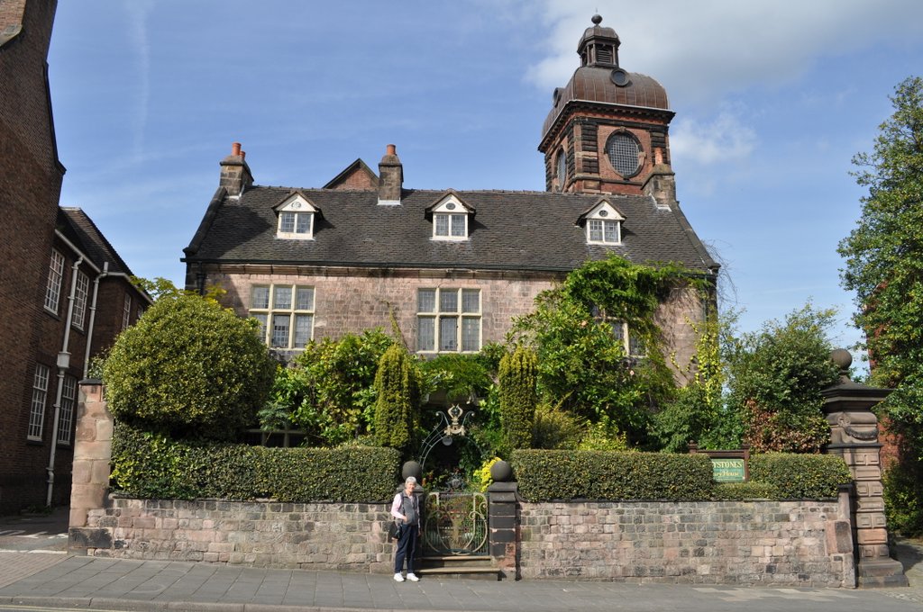
Yesterday, however, I read another account that states that the Prince did not stay in this house after all, but lodged instead in a much finer house, one built in the late 17th century, and located about 200 m east on Stockwell Street. Now a listed building, ‘Greystones’, was once divided into two apartments and rented by the local authority. From 1976 until the mid-1980s, my parents resided in the apartment on the upper two floors. I never had the least inkling whenever I visited them there that this just might have been the place where Bonnie Prince Charlie lay his weary head and dreamed on what might have been.
‘Greystones’ is a late 17th century listed building on Stockwell Street in Leek. It stands in front of the local library, art gallery and museum, the Nicholson Institute, the tower of which can be seen behind. ‘Greystones’ was once occupied by silk manufacturer Joshua Nicholson, who built the Institute in 1884.
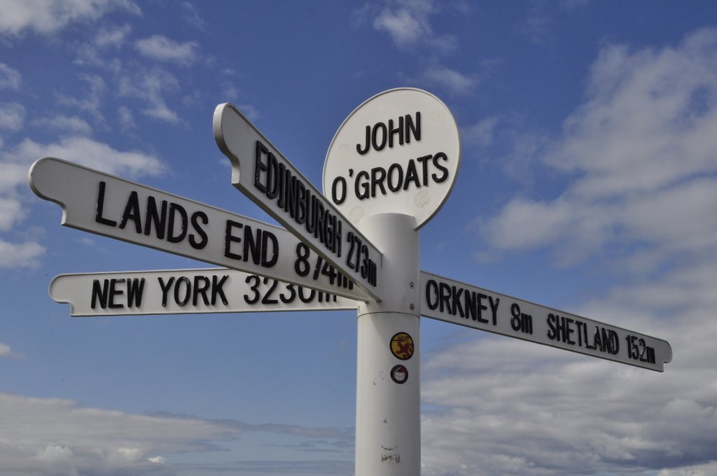
I have to admit being disappointed—but only ever so slightly—to discover that John o’ Groats is NOT the northernmost point on the British mainland (although apparently it is the spot where the ‘last house’ is situated.
Since everyone who undertakes a marathon walk, run or bike-ride the whole length of the country, usually for charity, starts or ends their journey in John o’ Groats (to or from Land’s End in Cornwall, with more than 800 miles between them). I don’t know why, but I’d always wanted to visit John o’ Groats. I guess because it appears in the news on a regular basis, an iconic location in our nation’s geography. So it was one of the places we included on our itinerary during our recent Scottish Highlands and Island road trip.
The actual most northern spot on the mainland is Dunnet Head, about 15 miles to west of John o’ Groats. Turns out that Land’s End is not the most southerly point either. That would be the Lizard Point, but which is actually closer to John o’ Groats by less than 10 miles.
We arrived in John o’ Groats under brilliant blue skies on the Saturday afternoon, and enjoyed clear views over the Pentland Firth, the stretch of what can be perilous waters between the mainland and the Orkney Islands, less than a dozen miles north. After wandering around the harbour, we than drove the couple of miles east to Duncansby Head, lighthouse and Stacks, enjoying even more spectacular views over the cliffs.
John o’ Groats, Caithness
The Orkney ferry in the harbour at John o’ Groats.
The harbour entrance.
Duncansby Stacks.
Looking west from Duncansby Head toward Dunnet Head, on the horizon.
Hoy from Duncansby Head
The Duncansby lighthouse.
Since our B&B accommodation for the night was in Thurso we drove there via Dunnet Head and its lighthouse to see the most northern point of the mainland for ourselves.
In the late afternoon sun we could even see the tip of the Old Man of Hoy sea stack above a headland on the northeast coast of the large island of Hoy immediately north.
The south-facing cliffs of Hoy in the late afternoon sun.
Dunnett Head, Caithness
Hoy from Dunnet Head. You can just see the Old Man of Hoy sticking up above the horizon on the left side of Hoy.
It was summer 1966. I was seventeen, and decided to visit the Outer Hebrides, more specifically North Uist, where the Royal Society for the Protection of Birds (RSPB) had just established a new reserve at Balranald near the village of Hougharry (Hogha Gearraidh in Scots Gaelic) on the west coast. Originally the reserve was aimed at protecting breeding populations of two special summer visitors: the corncrake and the red-necked phalarope. Sadly, the phalarope no longer breeds at Balranald.
So, with rucksack on my back, including a one-man tent and all the paraphernalia necessary to support me for a couple of weeks, I set off for Glasgow (where I spent a few nights with my eldest brother Martin and his wife, Pauline) before taking my first ever flight on a Vickers Viscount from Glasgow International Airport (formerly known as Abbotsinch) to Benbecula airport at Balivanich.
I pitched my tent in front of the small cluster of houses in Hougharry, and was invited in for several meals by the old lady with whom the recently-appointed (and temporary) reserve warden was lodged. If I remember, her name was Mrs MacDonald, and she was very kind and hospitable. I don’t remember the name of the young warden. He had just graduated in geography from the University of Hull. Well, I didn’t get to see the corncrake nor the red-necked phalarope, and when I visited again in 1967 I was also unlucky. But the experience was wonderful, and I fell in love with the Outer Hebrides, particularly North and South Uist. What a combination of nature! The machair and all its plant and animal diversity, the lochs and mountains, not to mention the sea life such as grey seals and killer whales. Pure air, no pollution!
I must have been almost the first visitor ever to Balranald in 1966. And I have just returned from a trip to North Uist—a walk down memory lane after 49 years. Still no corncrakes, however, though we did hear them.
Of course the islands have changed a great deal over the past five decades. Almost all of the old whitewashed and thatched croft cottages have disappeared, once so typical of the Uist landscape. Many cottages are now roofless shells, the roofs presumably deliberately removed to remove any property tax liability. There has been an enormous house building boom in the past 20 years or so, I guess. I was told that with government grants it was cheaper to build new, energy-efficient housing (necessary against the icy blasts that pour in from the North Atlantic) than to renovate.
Derelict house on the road to Lochskipport, South Uist
A typical thatched croft cottage.
A derelict blackhouse
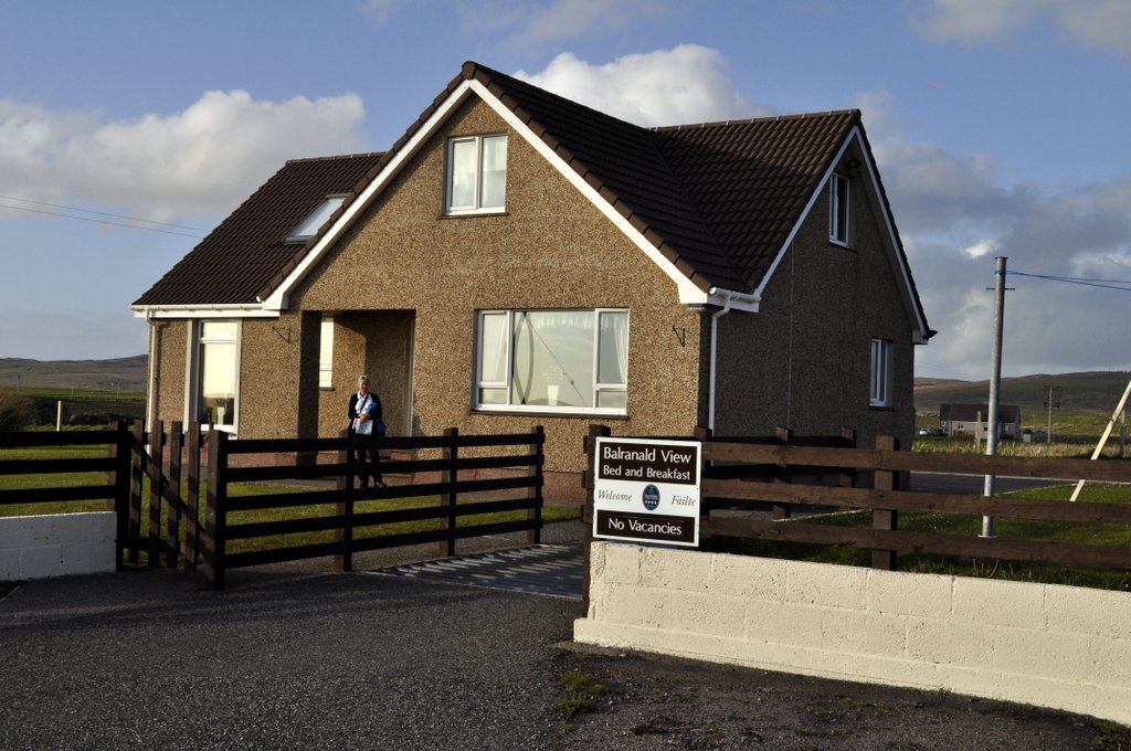
I wasn’t able to work out where I had camped in Hougharry nor which was Mrs MacDonald’s house. But I was pleased that I had been able to return and revive good memories from my youth. We stayed a couple of nights at a B&B at Balranald, overlooking the reserve, with Hougharry on the horizon. Run by Mrs Julie Ferguson, Balranald View was excellent. Julie was extremely welcoming, and her scones (with butter and mixed fruit jam) melted in the mouth.
Looking southeast and southwest from South Clettraval, east of Hosta on North Uist.
Looking south towards Kirkibost Island from South Clettraval
The bay at Hougharry with the village in the background.
Along the machair around the bay at Hougharry.
Kilmuir Cemetery, from Hougharry village.
A typical North Uist landscape, south of Hougharry.
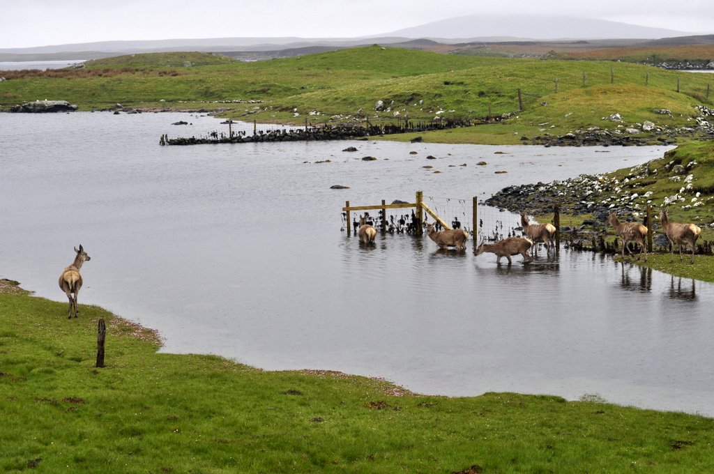
Red deer on the B894 to Loch Euport, near Sidinish.
The mountains of North Uist with Eabhal on the right, taken from the A867 to Lochmaddy.
A dreek morning wait for the ferry from Lochmaddy to Uig on the Isle of Skye.
Our B&B accommodation at Balranald, where hostess Julie Ferguson and her husband Roddy made us very welcome. Roddy was born in Hougharry.
Julie Fowlis
As a fan of the BBC series Transatlantic Sessions, I have increasingly become a fan of singer and TV presenter Julie Fowlis who has appeared regularly on that programme, and who I see from time-to-time whenever I tune into BBC Alba on catch-up TV. Well, she hails from North Uist—from Hougharry, in fact (so Julie Ferguson told me).
Here she is talking about her Hebridean roots and music. It’s a six minute film.
This song seems to have almost become her signature tune now: Hùg Air A’ Bhonaid Mhòir (Celebrate the Great Bonnet).
Steph and I have been members of the National Trust since 2011, and so we took advantage of reciprocal membership to visit several National Trust for Scotland properties during our recent Highlands and Islands holiday.
Gardens always feature high on our list of National Trust “to do’s”. Steph’s the gardener at home however. I’m just the admirer and mow the grass. But when we found that we’d be quite close to one of Scotland’s most important gardens, Inverewe in Wester Ross, we made plans to visit before crossing to the Outer Hebrides. We came across the other big garden, Arduaine in Argyll & Bute, quite by chance. It was just a few miles from our accommodation on the penultimate night of the holiday. The third garden was attached to Brodie castle just east of Inverness that we visited on Day 3. We turned up at Brodie only to find that the castle was not open to the public on a Friday, so we spent an hour wandering around the small garden and learning more about daffodils! More of that later on.
Inverewe Garden
This is an oasis of almost tropical splendour on the banks of Loch Ewe in northwest Scotland, about 50 miles southwest of Ullapool.
We spent the night of Day 5 of our holiday at Braemore about 12 miles south of Ullapool at the southern end of Loch Broom.
Loch Broom from the south.
Having booked passage on the 17:30 ferry to cross over to Stornaway on the Isle of Lewis from Ullapool, we had the whole day to visit Inverewe. The weather was not promising when we started out for Inverewe, with low cloud and spitting rain. Typical Scottish weather you might think. However, within just a few miles, the clouds lifted and we were treated to a bright sunny day for the rest of our journey and the two to three hours we spent walking around the garden before heading back to Ullapool for the ferry. Given that a major storm was expected later that evening, and as ferry crossings had been disrupted in previous days we did try to change our booking to the morning crossing at 10:30. No such luck as it was already fully booked. So we just went ahead with the plan we’d already made—and thoroughly enjoyed our visit to Inverewe Garden.
Opened in 1862, the garden was the brainchild of one Osgood Mackenzie who, having planted 100 acres of woodland to protect the garden, set about creating a sub-tropical paradise at almost 58°N, and nurtured by the warm waters of the North Atlantic Drift, full of exotic plant species.
It was taken into ownership by the National Trust for Scotland in 1952. Inverewe is famous for its rhododendrons and azaleas (some of which were damaged in gales in early 2015, especially some very old and large specimens), and is laid out in informal blocks representing different parts of the world, such as China, Tibet, Japan, New Zealand and the like. There are even tree ferns and several specimens of the very rare Wollemi pine from Australia.
Himalayan poppy at Inverewe Garden
Rhododendron at Inverewe Garden
In Inverewe Garden
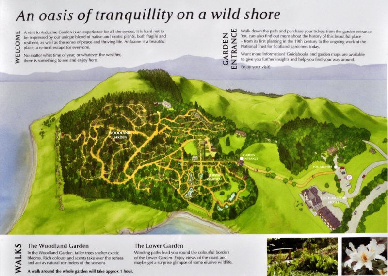
Arduaine Garden
Just 20 miles south of Oban beside the A816 (and 12 miles short of the village of Ford where we had a room booked) Arduaine Garden was a complete surprise. We originally passed it at about 17:30. It was already overcast, windy and drizzly, but we pulled in anyway to get our bearings and see when the garden was open. 09:00 to sunset! So we decide that if the weather was fine the following morning we would retrace our steps and spend a couple of hours there before re-retracing our steps to Ford, Loch Awe and on to Loch Lomond.
Established in 1898 by James Arthur Campbell on a peninsula jutting out into Loch Melfort (and with views from the headland all the way to the mountains on the Isle of Mull to the northwest), Arduaine lies at 56°N. It is full of rhododendrons and azaleas that were still in full bloom compared to what we had encountered at Inverewe. The garden was gifted to the National Trust for Scotland in 1992.
Arduaine has a more intimate feel about it than Inverewe, and perhaps for that reason I enjoyed my visit here more than to Inverewe.
Or was it because there were far fewer visitors at Arduaine? Afterall, we did arrive just a short while after garden opened and we had it almost to ourselves for the duration of our visit.
Arduaine Garden, Argyll & Bute
Rhododendron at Arduaine Garden
Rhododendron at Arduaine Garden
Arduaine Garden
Brodie Castle
Lying just to the west of Forres on the north coast of Scotland, Brodie Castle has been home to generations of the Clan Brodie, and the last clan chief lived there until 2003.
The castle was built in the 16th century. Major Ian Brodie, the 24th Brodie of Brodie, began assembling a collection and breeding daffodils in 1899, and eventually there were more than 400 different varieties grown. Some have been lost, but the National Trust for Scotland is attempting to re-establish this important collection. I never knew there was so much to daffodils.
During our recent tour of Scotland’s Highlands and Islands we traveled from Fife (where we had stopped the first night after traveling up from the English Midlands) up through Perthshire and Aberdeenshire, Speyside and the north coast and over to Inverness. From there we worked our way up the northeast coast to John o’ Groats and across the top of Scotland and down through Sutherland. We crossed over to the Outer Hebrides (Lewis, Harris, North and South Uist, Benbecula, and Eriskay) from Ullapool, then came back to the mainland via Skye. From there, via the Kyle of Lochalsh, we traveled down the west coast to Argyll & Bute, and over to Loch Lomond on our last day.
I took over 1000 photos on my Nikon D5000. On many occasions I felt I could only do justice to the landscapes we saw by taking a panorama of individual shots and combining them into stitches. The result for some is more than acceptable. For others, the blending between the individual frames is not even, but they nevertheless allow you to appreciate the beauty of these outstanding Scottish landscapes. Click on each of the photo below to open a full size version. I hope you enjoy these photos as much I did taking and editing them.
Taken from the A920 between Huntly and Dufftown, looking southwest.
The last battle fought on British soil was fought at Culloden (just east of Inverness) 0n 16 April 1746, when the Jacobite forces of Bonnie Prince Charlie were defeated by the Hanoverian ‘Butcher Cumberland’.
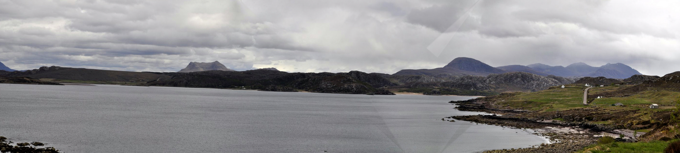
This bridge, west of Inverness, carries the A9 across the Moray Firth on to the Black Isle of Ross and Cromarty. Taken from North Kessock on the north shore, looking east.
From Dunnet Head – the most northerly point in mainland Britain – looking east towards Thurso and John o’ Groats.
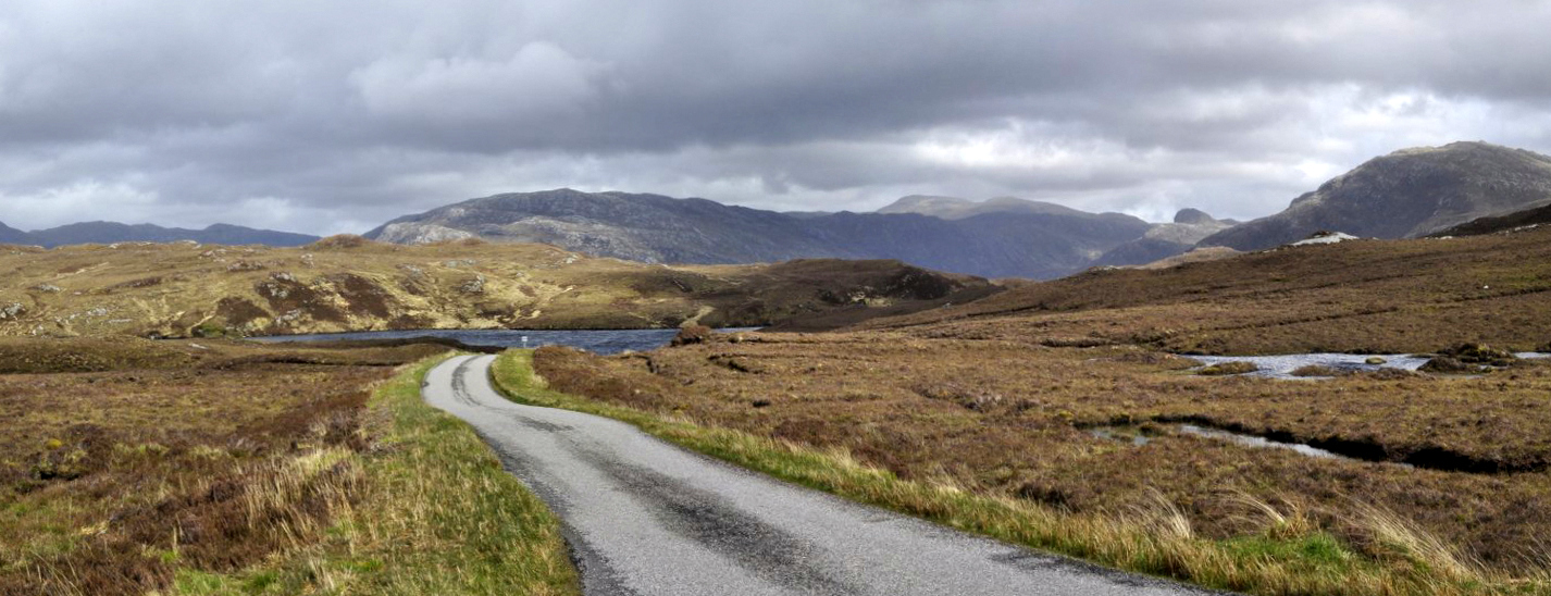
On the A836 westwards from Thurso.
At Coldbackie, near the Kyle of Tongue, on the A836.
Crossing the causeway at the Kyle of Tongue on the A838, west of Thurso.
Loch Eriboll, on the A838, looking southwest from near the mouth of this sea loch on the north coast of Scotland just east of Durness.
Looking westwards along Loch Inchard, near Rhiconich on the A838 in northwest Sutherland.
Loch Laxford, on the A838 in northwest Sutherland.
Approaching Laxford Bridge, looking southwest , on the A838.
Loch a’ Chairn Bhain, on the B869 heading west after Unapool.
Near Drumbeg, on the B869, heading west.
Drumbeg viewpoint, on the B869.
Heading east on the A837 between Lochinver and the junction with the A894.
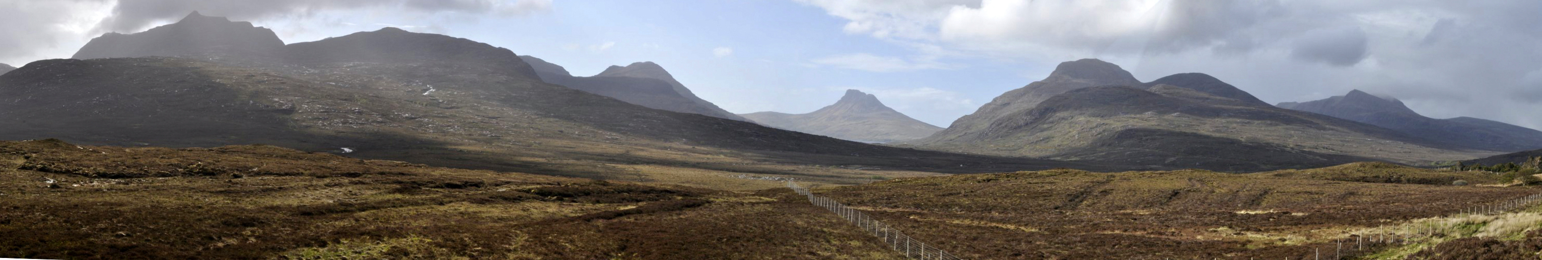
At Strathcanaird on the A835, looking west towards Ben More Coigach, Stac Pollaidh and Cul Mor.
Little Loch Broom on the A832 towards Inverewe (from Ullapool).
Gruinard Bay along the A832 towards Inverewe Garden.
Looking north across Gruinard Bay (on the A832) to the mountains of the Coigach beyond Ullapool.
The foreshore at Inverewe Garden, looking south at the southern end of Loch Ewe.
The walled garden at Inverewe and the southern end of Loch Ewe.
The landscape of Lewis north of Stornaway.
The Butt of Lewis, almost 59°N. Next stop: North America. Cliffs covered with fulmars, shags, and kittiwakes. And sea pinks, of course.
The mountains of South Harris.
Crossing the Sound of Harris (with Harris on the horizon) to Berneray and North Uist.
On the A865 heading east towards Lochmaddy from Bayhead in North Uist.
Looking southeast over North Uist with the mountain Eaval near Lochmaddy on the left, and the mountains on the right in the distance on South Uist.
The mountains of South Uist (looking east) with Ben Mhor on the right.
Machair and mountains at Garrynamonie, South Uist (looking east).
Machair at Mhalacleit, South Uist.
Ben Mhor on South Uist, looking west from Loch Eyenort.
Houses on Eriskay, looking southwest towards Barra.
The hills of north Skye looking south towards Staffin.
The Cuillins of Skye, looking southeast along the A863 near Drynoch.
Looking southwest along Loch Long at Conchra (near Dornie on the A87) towards Eilean Donan castle.
Looking northeast from the southern end of Loch Awe in Argyll & Bute towards the mountains of Glencoe.
Looking north along Loch Lomond at Inverbeg.
In due course, I’ll be adding more photos to individual posts I am drafting about particular places we visited on our 2,260 mile trip.
Well, we took the high road and the low road, and have just returned from a thoroughly enjoyable road trip road Scotland.
Over 2,250 miles in 13 days!
While I’ll be posting individual stories about the many things we did and saw during this trip, here are some of the highlights.
The decision to tour Scotland this year was almost a ‘spur of the moment’ one. Our daughter in Minnesota and her family had originally planned to come over to the UK later in the summer. But for various reasons this hasn’t worked out. But we had already decided that if they visited us this year, we would not travel to the USA as we have been doing annually for the past five years. So I suggested to Steph that we should make a road trip right round Scotland – to the Highlands and Islands. And that is what I began planning in about mid-February. By the beginning of April Hannah had told us that they would not be able to travel to the UK this year. So we have decided to visit Minnesota in any case, in September, just in time to see Callum begin school.
I’ve visited many different parts of Scotland on other trips, and have even been to the Outer Hebrides twice—almost 50 years ago! While Steph lived in Edinburgh for about 8 months in 1972-73, she never traveled further north. Neither of us had been ‘right round the top’. So we anticipated quite an adventure as we planned each stage of the trip. We had booked all our Bed & Breakfast (B&B) stops ahead of travelling, and the ferries, so it was just a case of enjoying the route and wherever our fancy took us each day. I have provided links to all the routes we took.
Day 1: 27 May (326 miles) Home to Comrie (Fife) Route
This was a ‘getting to Scotland’ day from our home in Worcestershire. Just a long drive up the M6/M74 motorways, and to visit with my sister Margaret and her husband Trevor in Fife for one night.
Day 2: 28 May (163 miles) Comrie to Huntly (Aberdeenshire) Route
Our destination was Huntly in north Aberdeenshire, which is the home town of my sister-in-law Pauline. I first visited there in November 1965 for Martin and Pauline’s wedding. Crossing the rolling hills north of Fife, we headed to Blairgowrie in Perthshire (where we spotted a couple of red squirrels in the woodland beside the River Ericht), and then into the Cairngorms National Park through Glen Shee. We also passed by Balmoral. No, Her Majesty was not at home.
Former textile mills along the River Ericht in Blairgowrie
Ramsons (Allium ursinum) in abundance in woodland along the River Ericht
Glen Shee, looking south
Glen Shee, looking north
Day 3: 29 May (143 miles) Huntly to Braes of Kinkell (Ross & Cromarty) Route
From Huntly we headed west through Speyside, and then up to the coast just west of Inverness, visiting two National Trust for Scotland properties at Brodie Castle (which was unfortunately closed) and the site of the 1746 Battle of Culloden.
Bridge over the Moray Firth west of Inverness
Culloden Battlefield
Brodie Castle
Day 4: 30 May (172 miles) Braes of Kinkell to Thurso (Caithness) Route This was totally new territory for me. Although the day started cloudy the sun soon broke through. And by the time we reached John o’ Groats it was a beautiful late afternoon, and there were clear views across the Pentland Firth to the Orkney Islands. We could even see the Old Man of Hoy. After a visit to Duncansby Head lighthouse, we stopped off at Dunnet Head (the most northerly point on mainland Britain) before heading to our B&B in Thurso.
The hills were golden with gorse (and broom), south of Wick on the northeast coast
The bluebells of Scotland!
It’s a long way to anywhere!
The Orkney ferry in John o’ Groats harbour
The cliffs at Dunscansby Head
As far north as you can travel on the British mainland
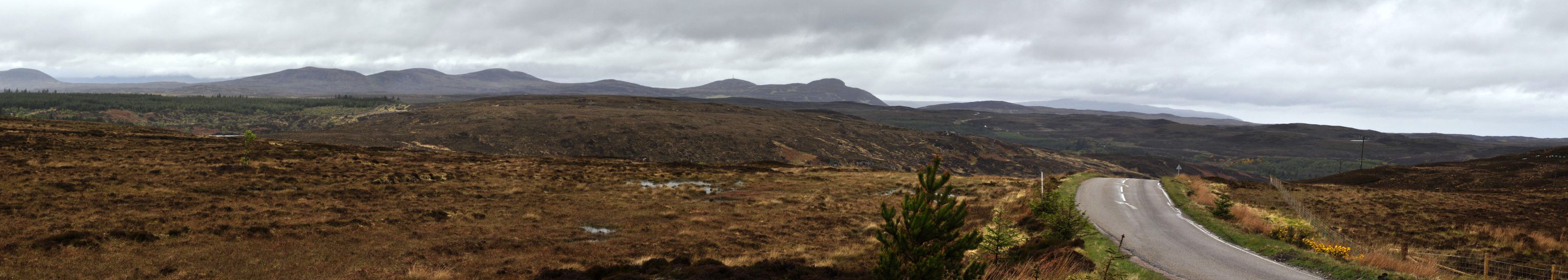
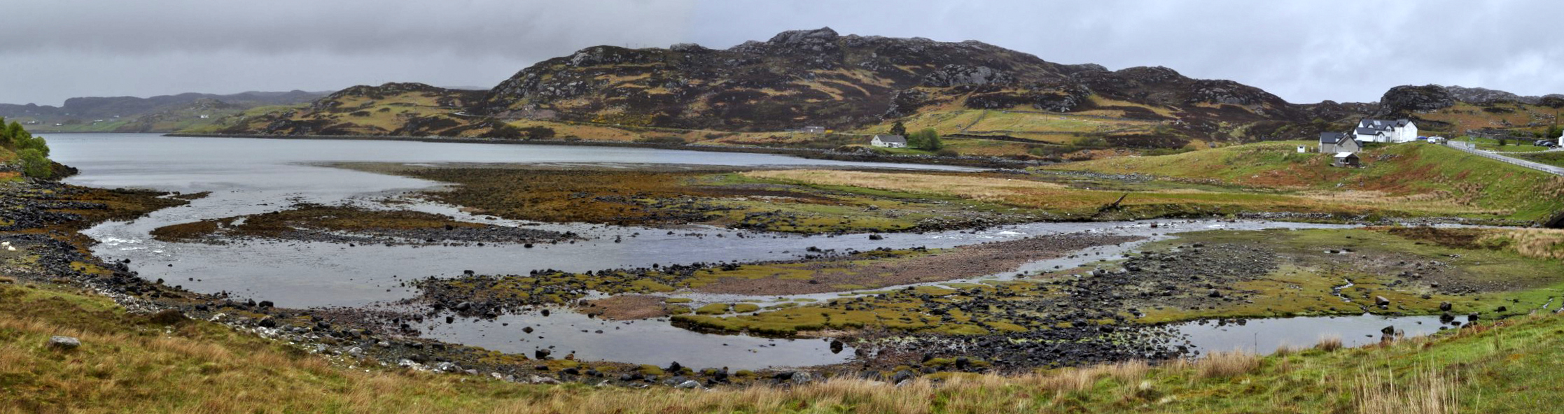
Day 5: 31 May (182 miles) Thurso to Ullapool (Ross & Cromarty) Route Sunday morning dawned drab and dreary—dreek as they say in Scotland. The day did not look promising as we headed west out of Thurso, past the former nuclear power plant at Dounreay (in the long process of decommissioning), towards Durness and down the coast of northwest Sutherland to Ullapool where we would take the ferry over to the Isle of Lewis on the following day. The weather forecast was not promising, with strong storms expected for the next 48 hours or so. But we were determined to take in as much of the journey as the low clouds would permit. However, by about 2 pm, the clouds had lifted, the sun had come out, and we were treated to magnificent views of some of the most impressive mountains in Scotland. A side excursion around a peninsula near Lochinver was certainly the highlight of today’s journey, along a very narrow, twisty, and at times very steep road with multiple passing places. It was along this road that I’m sure I saw an osprey hovering above the loch to the side of the road.
Dounreay power station
Loch Eriboll
Just north of Rhiconich, Sutherland
Laxford Bridge
North of Loch a’ Chairn Bhain
Looking south from the A837 between Lochinver and Loch Assynt
Day 6: 1 June (91 miles) Ullapool (via Inverewe Garden) to Stornaway (Isle of Lewis, by ferry) Route With a major storm due to hit later that day, we did contact the ferry operator about transferring to a morning crossing to Stornaway. But to no avail. The boat was fully booked. Not to worry. We just got on with our day as planned, and that was a side trip to the National Trust for Scotland’s Inverewe Garden, about 40 miles from our overnight B&B south of Ullapool. Although we started our journey in the rain, the clouds soon parted and it was bright and sunny by the time we reached the garden, and then spent more than a couple of hours wandering around this fascinating site. It’s special because plants flourish here so far north because of the influence of the warm waters of the Gulf Stream (more correctly the Northern Atlantic Drift).
We were back in Ullapool in time to catch the ferry at 17:30 to Ullapool, and departed under increasingly threatening skies. It was pouring with rain by the time we docked in Stornaway at 21:00. While the sea was definitely choppy, the crossing was smooth on the new and larger ferry, Loch Seaforth that entered service with Caledonian MacBrayne only a couple of months earlier.
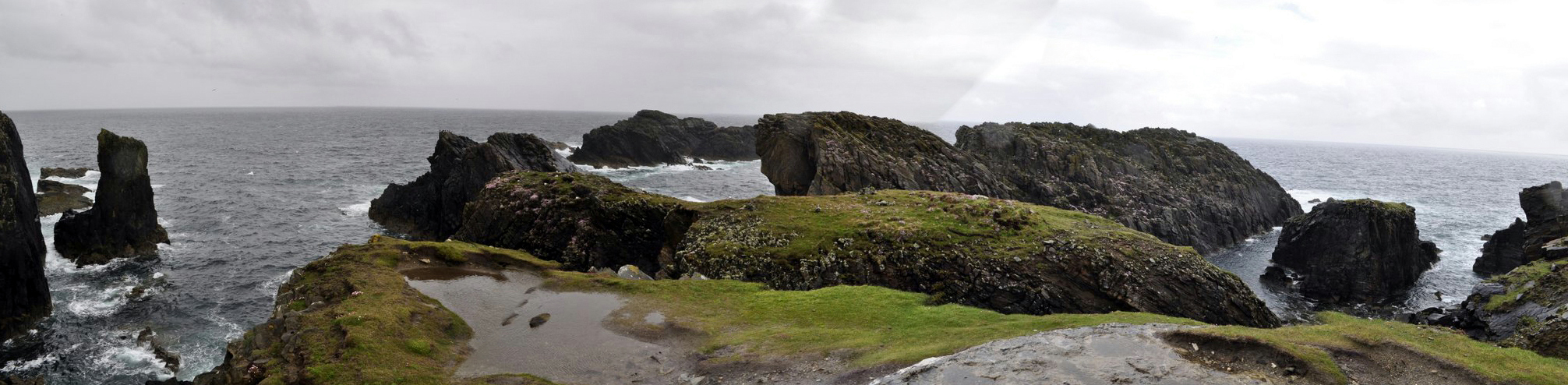
Day 7: 2 June (150 miles) Stornaway to Tarbert (Isle of Harris) Route We had three targets for today’s trip around Lewis: the Butt of Lewis at the northern tip; the Calanais Stones, and the iron age village at Bostadh on Great Bernera. It was heavily overcast as we headed north, and the skies became even more lowering as we approached the Butt of Lewis. In fact, it was raining very heavily when we arrived, and blowing a gale. The winds didn’t die down, but the rain did stop for a while allowing us to have a walk around, and take care not to be blown over the cliff.
The standing stones at Calanais are indeed impressive—mystical even, and I’ll be writing a special blog post about these in due course. With some due diligence, bobbing and weaving I was able to take all the photos I wanted, and hide any other visitors behind the various stones, so it seems as though Steph and I were the only visitors. The camera never lies!
We had to cross the Atlantic Ocean to reach Great Bernera. Well, cross the Atlantic is a bit of an exaggeration. Great Bernera is an island just 100 m across a channel from Lewis, connected by a bridge through which the Atlantic flows.
The bridge connecting Lewis and Great Bernera
Iron Age village site at Bostadh
While three or four Iron Age houses have been found in a shallow valley close to the beach at Bostadh, only one has been reconstructed. The others were filled in with sand after excavation because of the fragile nature of the substrate on which they had been constructed. In seeing this site of early settlement and others around Lewis and the other islands, one can’t help imagining what survival must have been like thousands of years ago, how agriculture developed, and how these early people survived from farming and gathering shellfish along the shore.
Steinacleit stone circle
We then headed south into Harris, and our B&B just south of Tarbert.
Day 8: 3 June (105 miles) Tarbert to Balranald (North Uist, by ferry) Route on Harris / Route on North Uist We took the A859 as far south as possible to Rodel where there is an impressive early sixteenth century church, St Clement’s (apparently dedicated to Pope Clement I), the church of Clan MacLeod. There is a fine tomb of Alasdair Crotach MacLeod of Dunvegan and Harris, 8th Chief of MacLeod.
Then it was on to the Sound of Harris ferry from Leverburgh to Berneray, and over the causeway on to the island of North Uist. I had first visited North Uist in the summer of 1966 at the age of 17, just after the Royal Society for the Protection of Birds (RSPB) had established its Balranald Reserve near the village of Hougharry (Hogha Gearraidh). I was then among the very first visitors to the reserve—if not the first! We stopped by Hougharry, but it has changed so much in the past half century—as have all the islands. Gone are the typical thatched roofed crofts and other single storey houses. Everywhere is new and relatively new construction. Given grants for new housing, it was cheaper to build new than renovate the original homes. Roofs were removed and what few old buildings remain are in a state of decay.
South Harris near Rodel
St Clement’s church
The Sound of Harris ferry
Crossing the Sound of Harris
The village of Hougharry that I first visited in 1966
The RSPB ‘office’ at Balranald
Day 9: 4 June (147 miles) Balranald Route to Eriskay Under fair skies (more or less) we spent the day traveling to the south of the Uists, through Benbecula and South Uist, and on to Eriskay, connected by causeway to South Uist since 2002.
The causeway connecting South Uist and Eriskay
First beach of silvery sand after crossing the causeway on to Eriskay from South Uist
Looking across to Barra from Eriskay
The ‘boat altar’ in the Roman Catholic church of St Michael on Eriskay
Day 10: 5 June (142 miles) Balranald to Dornie (Ross & Cromarty, by ferry via Isle of Skye) Route on North Uist / Route on Skye It was pouring with rain as we left Balranald, and as we sat in the car waiting for the ferry in Lochmaddy for the ferry crossing to Skye, we wondered whether there was any chance of seeing any of the magnificence of the mountains on Skye later in the afternoon.
We were not disappointed! As we crossed The Minch (the channel between the Hebrides and the mainland) we could see the skies clearing to the west. And as we docked in Uig on Skye around 2 pm, there was hardly a cloud in the Skye, and we were treated to some incredible landscapes. We traveled right round the north of Skye, down to Portree, back up towards Uig, but turning off towards Dunvegan, and then turning south down the west coast to join the main A87 at Sligachan. The Cuillin Mountains were lit up in the bright afternoon sunshine. However, once we arrived at the Kyle of Lochalsh bridge to cross over on to the mainland, we were back in cloud and rain. But once again, we had our spirits lifted when we came out of the restaurant in Dornie later that evening, and Eilean Donan castle was bathed in the rays of the setting sun. See our route here.
Eilean Donan castle in the late evening sunshine
Looking south towards Staffin on the northeast coast of Skye
The ferry in Uig harbour, Isle of Skye
The Cuillin Mountains of Skye
Day 11: 6 June (184 miles) Dornie to Ford (Argyll & Bute) Route This was perhaps the least enjoyable day of our holiday. Why? Well, by the time we reached Fort William the weather had deteriorated markedly and our side excursion to see the Glenfinnan monument and railway viaduct at Glenfinnan was made in the pouring rain and a howling gale. But it was the actual driving conditions that bothered me. There was much more traffic than we had experienced at any other day, and all travelling at high speed. It just wasn’t possible to motor along at your own pace, and stopping places were few and far between. Once we had left Oban further south, the volume of traffic dropped on the Argyll & Bute coastal route.
Flaming June – with snow still on the mountains, some of it quite recent
The Glenfinnan Viaduct
The Glenfinnan Monument, commemorating the landing of Bonnie Prince Charlie and the raising of his standard during the 1745 Jacobite Rebellion
Day 12: 7 June (187 miles) Ford to Lockerbie (Dumfries & Galloway) Route We had passed Arduaine Garden the night before, about 12 miles short of our B&B in Ford.
So this morning, under clearer skies, we headed back to this delightful garden located on a peninsula jutting westwards towards North America. We spent a couple of hours wandering around, admiring the beautiful rhododendrons. Then it was a long drive along Loch Awe, heading down to Inveraray, and on to Loch Lomond, before skirting Glasgow and joining the M74 once again after almost two weeks for the drive to our last overnight stop in Lockerbie.
Loch Awe, from the southern end
Looking north on Loch Lomond near Inverbeg towards the mountains near Glencoe
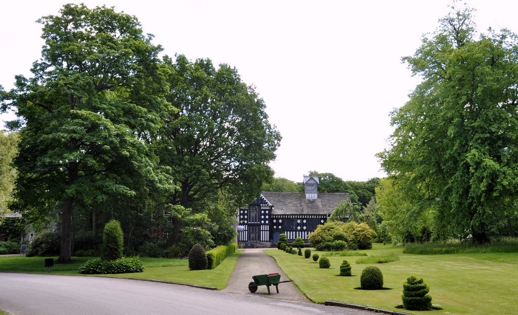
Day 13: 8 June (267 miles) Lockerbie to HOME! Route We set out just after 9 am, and after seven miles we had passed the 2,000 mile distance on our journey. But it wasn’t to be a quick dash home (if 250 plus miles can be called a dash). We broke our journey almost equidistant between Lockerbie and home, at Rufford Old Hall, a Tudor mansion just south of Preston, and owned by the National Trust.
It was a long trip in such a relatively short time. But was it worth it? Definitely! I doubt that we’ll go back to the north of Scotland. And although the saying goes Haste ye back!,we have so many other places we want to visit. Nevertheless, I’m very happy that we made the effort. The scenery was uplifting, and we received a friendly welcome wherever we went. Scotland—weather and all—was a delight. There was one BIG advantages of the cool weather. No midges!
Here are links to detailed accounts about our trip:

 So I was drawn to the fiction shelves, and suddenly had the bright idea to check out if there were any books by acclaimed Scottish author Peter May. Now I have to make a confession here. Until my recent trip to the Outer Hebrides I’d never heard of Peter May (although I think my wife Steph had read a couple of his books). Anyway, to cut a long story short (excuse the pun), I found a couple of May’s books on one of the lower shelves and decided to take them out on loan.


 How would Britain as a nation and British society have evolved had the 1745-46


 Well, we took the high road and the low road, and have just returned from a thoroughly enjoyable road trip road Scotland.