Blink, and you’d pass through Cave City, KY without realising it. Maybe I’m being a little unfair. But the town obviously caters to the myriad of tourists passing through or, like us, stopping overnight, for a visit to Mammoth Cave National Park, just a few miles to the west.
One positive thing about Cave City, however. There was a very good Mexican restaurant just a couple of blocks from our hotel, serving great food and ice cold Mexican beer—most welcome after a long day’s drive.
We visited Mammoth Cave NP on the morning of Day 8 (Wednesday) of our Georgia-Minnesota road trip. Our next stop was Troy, IL, to the northeast of St Louis, and some 370 miles, a distance we normally covered in a whole day. But with our scheduled visit to Mammoth Cave NP in the morning, we knew we would have to cover that distance in much less time than usual if we were to arrive to our hotel at a reasonable hour. And we already had a scheduled stop in southern Illinois at the confluence of the Mississippi and Ohio Rivers.
When researching Mammoth Cave earlier in the year, I discovered it was a very popular destination, especially during the school summer breaks. Now, while we made our trip just before many schools were out for summer, we did expect the national park to be reasonably busy, so decided to book places on one of the first cave tours available. With my ‘weakened’ leg, I didn’t want to take one of the tours that might involve scrambling over uneven surfaces in the dimmed light. The last thing I needed was a twisted ankle – or worse.
The surface area of Mammoth Cave National Park is only 82 square miles (some 53,000 acres), but there are more than 400 miles of surveyed cave passageways. And some experts believe there could be as many as 600 miles of undiscovered passageways. The cave system at Mammoth Cave NP is the longest in the world, and became a UNESCO World Heritage Site in 1981.
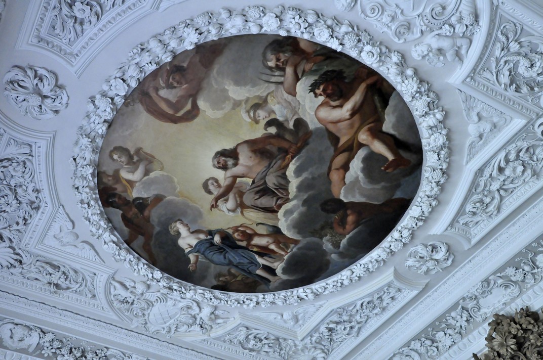
Dominated by the Green River (apparently one of the most biodiverse in the USA), and predominantly a limestone karst landscape overlain by a harder sandstone, the caves offer some spectacular sights. There are huge caves open to the public. Notwithstanding time (and access) limitations, our visit to Frozen Niagara gave us (according to our ranger guide) a glimpse of what the whole cave system had to offer.
There has been a long history of exploration and commercial exploitation of the caves, and of course millennia of occupation. There has also been tragedy, with one enthusiastic caver Floyd Collins becoming stuck in a passageway in 1925, and dying before he could be freed.
There is limited and subdued lighting in Frozen Niagara. Thus photography was quite a challenge. Having a good Nikon digital SLR, I was able to make some adjustments, but the end results are not altogether satisfactory. Counter-intuitively, I found that underexposing each shot achieved a better result. I can’t explain why. Anyway, the selection below shows something of the splendour of this easy entry cave.
Mammoth Cave, KY
In the Visitor Center, there is a very nice exhibition (some interactive) showing the geological and human histories of the caves.
More information about the caves can be found here.
Short and sweet, but a worthwhile and interesting visit. Recommended!
Before noon we’d completed our tour, made the necessary ‘comfort stops’, and were ready to hit the road once again, westwards to the mighty Mississippi.
Everyone, every company and organization needs, it seems, a brand. A logo that identifies the brand, and a pithy slogan that suggests orientation, ethos, qualities, aspirations.
Take the International Rice Research Institute (IRRI) for example, where I worked for almost 19 years. It has a distinctive institution logo, in a defined font and font color, and a branding logo and slogan, that succinctly describes the objectives and mission of the institute: Rice Science for a Better World. I was a member (Chair perhaps, I don’t remember) of the committee that came up with this slogan, and my former colleagues in the Communication and Publications Service (CPS) under Ohioan Gene Hettel, then developed the clever logo below.
In the automobile industry, take Ford for example: Go Further . . .
or Nestlé as an example from the confectionery and food industry.
Branding is a real industry, and there’s a lot of ‘science’ behind adopting and deploying the right brand. Even cities get involved.
US states are not immune. As we travelled around the eleven states on our journey from Georgia to Minnesota in June this year, I took photographs of all the state signs at the state lines (except Kentucky – I had to find its brand logo elsewhere). Each of the eleven (with the exception of North Carolina, Missouri, and Minnesota) had a brief slogan to describe itself, such as Virginia is for Lovers, or Wild and Wonderful (West Virginia).
The one that caught my eye, however, and is (as far as I know) quite famous world-wide, is the Kentucky brand.
What an inspiration! Encapsulating, one would think, two of the things that Kentucky is most famous for: the breeding and racing of thoroughbred horses (viz. the Kentucky Derby) and the distillation of fine bourbon whisky.
But these were not, apparently, the ideas behind the brand. Kentucky Unbridled Spirit means that the state is a place where spirits are free to soar and big dreams can be fulfilled. We relish competition and cherish our champions for their willingness to push beyond conventional boundaries to reach new heights of success.
Kentucky has obviously thought in depth about branding. As it states on its website, and citing a Tufts University study, A brand’s purpose is twofold: One – it serves as a major tool to create product differentiation: and Two – it represents a promise of value. From a consumer’s viewpoint, a brand is – above all – a shortcut to a purchasing decision.
Read more about Kentucky’s branding decisions here. I still see racehorses and whisky, and that not so bad really.
Our journey through the Appalachian Mountains (the main focus of our 2017 road trip in the USA) took almost four days traveling through Georgia, North Carolina, Tennessee, Virginia, West Virginia, and Kentucky.
The Appalachians comprise a large system of mountains and valleys, covering a vast area of the eastern USA, and extending into Canada. We explored just the southern end.
Day 4 began in Greenwood, SC where we had stopped the night after traveling north from Savannah, GA the previous day. Leaving our hotel not long after 8 am, we headed west crossing quite soon back into Georgia and working our way northwest through the Chattahoochee National Forest towards Blairsville, GA.
The winding 35 mile climb on GA60 into the Chattahoochee (map) began at Stonepile Gap. With towering trees either side of the road there were few places to stop or see out over the landscape. One of these however was Chestatee Overlook, where we had a first real view of the rolling—and heavily forested—Appalachians.
We expected to arrive in Blairsville after 5 pm, but we were there by 3:30. Rather than heading straight to our hotel, we decided to make a 50 mile circuit to the north and east of Blairsville, and quite by chance came across the entrance to Brasstown Bald, the highest mountain in Georgia, at 4784 feet.
There is a steep drive up to the car park, and a shuttle bus takes you up the final (and very steep) final mile to the observation platform. We arrived around 4:30, just in time to catch the final shuttle of the day, but allowing only about 15 minutes at the summit before the last shuttle would depart for the car park. Given the steepness of the descent (14%), and concerns that my right leg might suffer, we opted for the return shuttle. The visit was somewhat marred by several bikers (who were old enough to know better) using the climb to the car park (a couple of miles at least on a winding road) to ‘race’ their very noisy chopper motorbikes. Quite unnecessary really.
However, it was a glorious afternoon, and the 360° panorama afforded views into North Carolina and Tennessee to the north, and probably Virginia to the east. Just imagine what it must look like in September and October ablaze in all its Fall colours.
The view from Brasstown Bald, GA
The following day, Sunday, our destination was Johnson City, TN taking in the Cherohala Skyway (map), a 50 mile scenic route stating at Tellico Plains, TN and ending at Robbinsville, NC.
The day started fine and sunny, and we weren’t disappointed in the Cherohala. Then we headed to the Great Smoky Mountains National Park, crossing south to north (map) towards Gatlinburg, TN on US441. Unfortunately, by the time we reached the park (one of the busiest in the whole of the country), the weather had deteriorated and it was raining heavily. The Smoky Mountains really were smoky. On the off-chance that we would be above the clouds, we took the seven mile diversion to Clingmans Dome on the North Carolina-Tennessee border, the highest point in the Smokies, at 6643 feet.
There was not a lot to see, to say the least. But dropping down towards Gatlinburg, the clouds did lift and we saw something of the Smokies after all.
Not long after we headed out, we ran into one of the most intense storms I’ve ever experienced. It was raining so hard I could hardly see in front of the car. We did wonder whether our visit to Cumberland Gap would be a wash out. But the closer we got, the weather started to improve, and the sun was even shining as we arrived at the national park. From the Pinnacle Overlook it was hit and miss, now you see it, now you don’t as the clouds closed in, then cleared. But we did have some wonderful views, nevertheless.
The Cumberland Gap has been a major route through the Appalachians for Native Americans and the Europeans who settled there, and wanted to head west.
Overlooking the Cumberland Gap
Cumberland Gap was a strategic route for both Union and Confederate armies during the American Civil War, and exchanged sides from time to time. There are still earthworks high up on the Pinnacle.
The following morning we set off early from Charleston, west into Kentucky. It was going to be a long day, and a rather complex route on minor roads through the Daniel Boone National Forest. This was gently rolling country, but nevertheless magnificent in terms of the trees lining the highways.
Towards the end of the afternoon, we hit the main highways again, heading further west to Cave City, KY for the night, and the next highlight of the trip: Mammoth Cave National Park.
Sitting down yesterday, enjoying a DIY cup of coffee at the The Weir Garden (a few miles west of Hereford), I commented to my wife that we had to be thankful for the eccentricities of the former owners of many of the National Trust’s properties.
I’d picked up a copy of the Trust’s Spring 2017 magazine and there on the cover was a photo of an exceedingly eccentric individual: the 5th Marquess of Anglesey, Henry Paget (whose country estate was Plas Newydd on Anglesey that we will visit in September on our way to Holyhead, and a week’s tour of National Trust properties in Northern Ireland). They could pander to their eccentricities because they were wealthy. And many of them spent their wealth—often to their ruin—in developing large houses and estates, and filling them with the most wonderful artefacts. That’s what we can enjoy today thanks to the work of the National Trust.
A Weir Estate is recorded from the reign of Henry VII in the late 15th century. But the Romans were there over 1000 years earlier, and the remains of a villa or temple have been excavated on the banks of the River Wye that flows past.
The Weir Garden was originally laid out at the end of the 18th century, but it wasn’t until the 20th when wealthy Roger Parr became owner did the garden really flourish. He revitalised the walled garden, installing a state-of-the art (for the 1920s) glasshouse. The house is now a nursing home, and has been ever since the estate became the property of the National Trust in 1959.
The south-facing Garden is certainly worth a visit, and must surely show different ‘faces’ at different times of the year. There are few formal parts—a small rock garden surrounded by elegant Acers—but mostly the garden, laid out on the steep slopes along the river below the house, is woodland with oaks, London plane trees and a few tulip trees dominating the landscape. And as the paths weave their way through the woodland, there are vistas over the River Wye east and west. What a river; fast flowing, but clear as a bell, and no doubt full of trout and other fish. There is a report of an eight foot sturgeon having once been caught in the vicinity in the 19th century.
These photos (and a short video) are my take on The Weir Garden in early July, according to the locations indicated on the map above.
(2) Rustic hut
(3) Rockery
(4) Viewing bridge
(6) River meadow and (7) River wall
(10) Roman ruins
(15) Walled garden and Foster & Pearson glasshouse
Yesterday (28 March 2019) the weather promised much for the day, so we headed west again to enjoy The Weir Garden during its Spring emergence. And we weren’t disappointed.
The trees were magnificent, with no foliage to hide details of their splendid skeletal architecture, although many were just beginning to come into leaf. Another thing we noticed (and on the drive through Herefordshire) was the amount of mistletoe in many of the trees; a veritable mistletoe haven.
So here are a few of the photos we took yesterday. A more complete album can be viewed here.
Savannah, Georgia. Founded in 1733, the oldest city in Georgia. It must be one of the most picturesque cities in the whole of the USA. Sitting just 20 miles or so upstream from the mouth of Savannah River on the Atlantic coast.
A city of squares and cobblestone streets, colonial houses, and Spanish moss dangling ubiquitously from trees surrounding the many colonial squares and lining broad avenues that cross the city.
Savannah. A city overflowing with Colonial, Revolutionary War, and Civil War history. A city full of historical markers, and some historical surprises. And, unfortunately, a city with one of the highest gun crime rates in the whole country.
Savannah was the first port of call on our recent road trip from Georgia to Minnesota. I’ve wanted to visit the city for a long time now. Not sure why that was the case, but it is one of those cities that you just have to visit, at least once.
We were not disappointed. And we had just an afternoon and morning to see the sights.
Having arrived to the USA on the Wednesday evening, and traveled just as far as Macon (about 80 miles southeast of Atlanta on I-75), we set off just after 09:00 on the following morning, after a reasonably comfortable night recovering from the journey over from the UK.
South of Macon, I-16 is mostly tree-lined the whole way to Savannah, and there’s little opportunity to see what the landscape is like, other than it’s rather flat. We easily found our hotel, Planters Inn on Reynolds Square, in the historic center of the city (see map), and I’d arranged for valet parking of our vehicle at a nearby multi storey car park.
Once we had settled into our room—upgraded to a larger one with a balcony—we set out to explore the River Street area just north of Reynolds Square, and find a bite to eat for lunch.
There’s so much to see. Along the Savannah River, River Street is lined by cotton warehouses now converted to commercial premises and apartments. Fortunately we were there at the beginning of the tourist season, but I can imagine that later on in the season, this area must be thronging with tourists. I was particularly taken with the wrought iron balconies that were a signature feature of many of the warehouses along River Street. It’s not hard to imagine what the cotton trade must have been like, and ignominy of slavery.
By Thursday evening we were rather tired, enjoyed dinner at the Cotton Exchange Tavern on River Street, and retired early to bed to catch up on our jet lag.
Next morning, with storms threatening by about 10 am, we decided to set out very early to explore the colonial streets of the city to the south of Reynolds Square, and heading to Forsyth Park. We had breakfast at 6:30, and were out of the hotel by 7:30. Within half an hour the first showers appeared, but lasted for just a few minutes, and it was more or less bright thereafter.
There’s one rather interesting surprise in Reynolds Square: a statue of John Wesley, one of the founders of Methodism, who spent a couple of years in Savannah from 1735.
An old cemetery is now the peaceful Colonial Park that we wandered through, the final resting place of so many of the great and good from Savannah’s past. It’s almost next door to Savannah’s Cathedral of St John the Baptist.
Colonial era houses still line Jones Street, and the history of Savannah during the Civil War of the 1860s is evident everywhere. Confederate President Jefferson Davis stayed there. Savannah was occupied by Union troops under General William Tecumseh Sherman after laying waste to Atlanta.
Forsyth Park (some 30 acres) lies at the southern end of the historic district, with an impressive monument to Confederate soldiers.
We returned to the hotel after about three hours, rather hot and sweaty, and took advantage of the hotel offer to use one of the restrooms on the first floor, to freshen up. Having cooled down, settled our bill, and called for our vehicle from the valet parking, we set off for Greenwood, just under 170 miles to the north in South Carolina, over the Talmadge Memorial Bridge around 11:30.
Greys Court is a National Trust property a few miles west of Henley-on-Thames in Oxfordshire. Owned by the Trust since 1969, and most recently the family home of the Brunners (first baronet and industrialist Sir John Brunner was co-founder of a chemical company that merged with others in 1926 to form Imperial Chemical Industries – ICI – in the UK). We spent three hours at Greys, taking the noon tour (that covers just the ground floor rooms) but returned later in the afternoon to explore the house more thoroughly including the library and bedrooms upstairs.
There has been a dwelling here for almost 1000 years. Greys Court today is an attractive brick and flint Tudor country house that underwent some embellishments during the 18th century. From the front of the house there are views over the Chilterns countryside.
Greys Court was erected by Sir Francis Knollys, a courtier under Henry VIII, Edward VI, and Elizabeth I. In 1724 it became the property of the Stapleton family who lived there until 1937 when it was bought by Liberal politician Sir Felix Brunner (third baronet and grandson of Sir John) and his wife Lady Elizabeth. She was the granddaughter of the famous Victorian actor Sir Henry Irving. Lady continued to live at Greys Court until her death in 2003.
The house is full of Brunner memorabilia, not the property of the National Trust. Photography is unfortunately (from my blogging perspective) not permitted inside the house. The plasterwork ceiling in the downstairs reception room dates from the 18th century when the height of the room was increased, and a crenellated two floor semicircular extension was added, clearly.
But the exteriors are delightful, and the small but exquisite garden excites the senses. Because Lady Brunner developed the gardens to explore, to entice, to delight, they were set out as a series of ‘rooms’ connected by gates or doors that invited the visitor to open and see what lay on the other side. One can walk through a wisteria arbour, 150 years old, wander between the silence of the White Garden (under the Great Tower), and check out the orchard and vegetable plots, all surrounded by brick and flint walls.
Outside the garden is a brick path maze (no hedges!), ‘symbolizing the journey through life’, dedicated by the then Archbishop of Canterbury, Robert Runcie, in 1981.
In the grounds there is a Tudor wheelhouse with a donkey wheel, drawing water up some 200 feet, and still in operation until 1914.
At the entrance there was a hand-written welcome sign to the property extolling the friendliness of the staff. And they were!
Yes. That’s right. Eleven states in just ten days.
2764 miles to be precise. Ninety-four gallons of gasoline consumed. Almost 30 mpg at just USD209. That’s not bad considering we rented a Jeep Patriot SUV (with a Connecticut licence plate!).
I’d opted for a car rental through Rentalcars.com and chose Alamo as the best deal. Just USD357 for the actual rental, USD250 for the one way drop-off fee, and USD98 for roadside assistance cover and various taxes.
I had planned our route meticulously, taking in various sites and landscape features I thought would be interesting, and avoiding as much as possible any of the interstate highways. I bought Rand McNally road maps for all states except Virginia and Minnesota (we already had a DeLorme Atlas & Gazetteer for MN). I checked precise US and State Routes using Google maps since the scale of the Rand McNally didn’t always show the road name. I even used Google Streetview to check the various intersections, and before we traveled I already had an image in my mind of the entire route.
I prepared daily detailed route plans on cards, which Steph used to navigate us across country from Atlanta to Minnesota, with each map marked at decision points corresponding to the route card details (you can just make out a series of circles on the map below).
Fortunately, US roads are very well signposted and road signs (e.g. US61 or GA23, for example) are posted every few miles. It was hard to go wrong, but we did on three occasions; nothing major, however. My first mistake was leaving the car rental center at Atlanta Hartsfield-Jackson International Airport. I turned on to I-85N instead of I-85S, but was able to turn around within a mile. On two other occasions we made a turn too early, but realised almost immediately. Not bad really for such a long road trip. Nor did we encounter any road works that held us up, or any road accidents. We almost never saw a police car.
These four map links show the actual route we took over the ten days:
We stayed in ‘chain’ hotels like Best Western, Comfort Inn, Quality Inn and the like, about USD100 or so a night. In Savannah we stayed at The Planters Inn on Reynolds Square, close to the river and other historic attractions, and this was our most expensive at around USD230 including taxes and valet parking. Breakfast (if you can call it that) was provided in each hotel. For lunch, eaten by the roadside or at a scenic viewpoint, we picked up a freshly-made sandwich and with some fruit from the hotel, we had enough to keep us going until a substantial dinner in the evening. Surprisingly, we ate Mexican on three nights and had very good meals. There was even beer! Twice we ate at the nearby Cracker Barrel Old Country Store – reasonable food but no beer. Walking into our second Cracker Barrel in Troy, IL it was déjà vu; the layout of the restaurant and the store was identical to the one we patronised in Johnson City, TN.
Anyway, here is a summary of our epic road trip.
31 May, Atlanta, GA – Macon, GA, 82 miles
Our flight (DL73) from Amsterdam landed on time just after 14:15, and despite arriving at an E pier and having to walk the considerable distance over to the new F International Terminal for immigration and customs, then taking a 15 minute shuttle to the new car rentals center beyond the airport perimeter, we were on the road not long after 16:00. We were headed to Macon on I-75, some 82 miles southeast of Atlanta towards Savannah to spend our first night, and recover—to the extent possible—from our long day of travel from Birmingham (BHX), arriving to our hotel (Best Western on Riverside Drive) just around 18:00
Just arrived at Best Western in Macon
We had the room on the right of the balcony, overlooking Reynolds Square
1 June, Macon – Savannah, GA, 167 miles
Since we had only a relatively short journey to reach Savannah, and because I wanted us to get a good rest before setting off once again, we didn’t leave Macon until after 09:00. Our hotel in Savannah (Planter’s Inn on Reynolds Square) had contacted me that morning by SMS asking what time we expected to arrive and hoping to have a room ready then. Not only was our room ready at just after 11:00, but we’d been upgraded to a balcony room. Once we had settled in, we set off on a leisurely stroll around the historic riverside where the old cotton warehouses have been converted to restaurants and other retail outlets, as well as apartments.
Savannah oozes history (and Spanish moss) – a direct line of historical events from the early 18th century, when it was founded, through Colonial times, and the turmoil of the Revolutionary and Civil Wars.
Savannah, GA
2 June, Savannah – Greenwood, SC, 196 miles We spent the morning in Savannah absorbing the Colonial, Revolutionary and Civil Wars history of this beautiful city. The weather didn’t look promising, with thunderstorms forecast, so we left the hotel by 07:30 and wandered through the various squares, parks and colonial streets for three hours, with just a small shower to bother us. After freshening up at the hotel and checking out, we were on the road again by 11:30, headed for Greenwood in the northwest of South Carolina.
The US17 route out of Savannah crosses the Savannah River over the fine-looking Talmadge Memorial Bridge, completed in 1991, 185 feet above the water.
We passed through a heavy rainstorm for the first 20 miles or so, but the weather brightened, and we stopped for a bite to eat beside the road in glorious sunshine. The road north was almost completely straight passing through small towns with names like Denmark, Sweden and Norway. There wasn’t much evidence of much agriculture, just some maize on this coastal plain with rather sandy soils. Communities seemed quite impoverished (according to the 2010 census it is the 7th poorest state). Nevertheless, the Southern Baptist (and some Presbyterian) churches and chapels stood in stark contrast. I’ve never seen so many places of worship so close together. There must be a lot of wicked souls need saving in South Carolina (and surrounding states) to require so many churches, often within just a few hundred yards of each other (or closer).
We were in Greenwood by 17:00, found our hotel, the Hampton Inn, and enjoyed steak and seafood meals at the Red Lobster outlet beside the hotel.
3 June, Greenwood – Blairsville, GA, 195 miles
Distance-wise this was never going to be one of the longest days, but I had planned our route climbing into the Appalachians through the Chatterhoochee National Forest on US60, a winding road among the trees.
We departed from Greenwood around 08:00 and made our first stop at the SC-GA state line to look over the Savannah River at Calhoun Falls. We had another stop at Cleveland, GA to tour the historic courthouse museum, and arrived in Blairsville by about 15:00.
Not wanting to go straight to our hotel, the Comfort Inn, so early in the day, we opted for a 55 mile round trip taking in some of the hills and forest to the north and east of Blairsville, arriving to Brasstown Bald, the highest point in Georgia at 4500 feet, around 16:30 just in time to take the last shuttle bus to the summit, and down again. I decided not to walk the 1 mile descent from the summit to the car park because the average gradient was more than 14%, and Steph and I were concerned that I might hurt my right leg, which is still giving me some grief 18 months after I broke it.
4 June, Blairsville – Johnson City, TN 282 miles
This was our opportunity of really traveling through the Appalachians. I’d chosen to travel east along the Cherohala Skyway in North Carolina. We had expected some poor weather this day, so set off as early as we could get away in order to enjoy the early morning brightness. The Cherohala offers some spectacular views along the way, and we were not disappointed at all.
Looking south from the Cherohala Skyway over North Carolina
But the further east we went, the more cloudy it became, and by the time we reached US441 to cross the Great Smoky Mountains National Park, it was raining quite hard and we didn’t really see very much at all. We took the side route of about seven miles to Clingman’s Dome, the highest point over 6600 feet. Couldn’t see a thing! But lower down on the north side, the weather improved and we did see something of the Smoky Mountains.
We then dropped down to Gatlinburg in Tennessee. If you’ve ever harbored the desire to visit Gatlinburg – don’t. What a tourist disaster! A narrow highway through the center of the town, tackiest tourist souvenir stores lining both sides, and even though this was early in the tourist season, there were throngs of people about. I’m glad we were only passing through. Then it was on to our hotel on the outskirts of Johnson City.
5 June, Johnson City – Charleston, WV, 380 miles
The focus early in the day was the Cumberland Gap, northwest of Johnson City by about 80 miles or so. Not long after leaving Johnson City, along US11, we passed through one of the heaviest rain storms I’ve ever experienced. I could hardly see in front of the car. But by the time we reached Cumberland Gap, the clouds had lifted somewhat, and the sun appeared.
The ‘Cumberland Gap’ is familiar to me from my skiffle days, as sung by Lonnie Donegan.
We went up to the Pinnacle Overlook, hoping to see the views over Tennessee, Virginia, and Kentucky – even as far as North Carolina on a good day. It was only a case of ‘now you see it, now you don’t’ as the clouds came rolling in, then dispersed. As a major pass through the Appalachians, the Cumberland Gap was strategically important for both the Union and Confederacy during the Civil War of the 1860s, and changed sides every so often. There is still evidence of military occupation high on the Overlook.
Looking north into Kentucky and the town of Middlesboro. The highway has just emerged from the tunnel through the Gap.
Then later in the day, heading east towards Charleston, the capital of West Virginia, we traveled along The Trail of the Lonesome Pine in Virginia. Until I was planning this trip, I wasn’t even aware that the Trail was a real entity, not after I’d heard Laurel and Hardy singing about it.
6 June, Charleston – Cave City, KY, 371 miles
Our destination this day was Cave City in central Kentucky where we planned to visit the Mammoth Cave National Park the following day. Heading west out of Charleston on I-64, we turned south at Morehead in Kentucky (about 110 miles west) to head south through the Daniel Boone National Forest.
We traveled some 125 miles along scenic highways and byways. Then we turned west on the Cumberland Parkway west of Somerset, KY for the rest of the day’s trip to make up some time and so as not to arrive to our hotel too late. However, Kentucky is divided into two time zones, so we gained an hour (from Eastern to Central Time) about 80 miles east of Cave City.
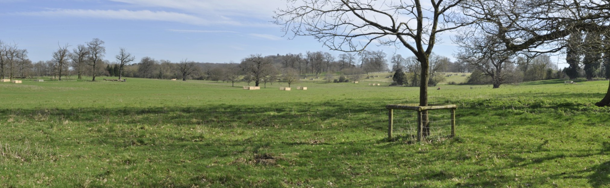
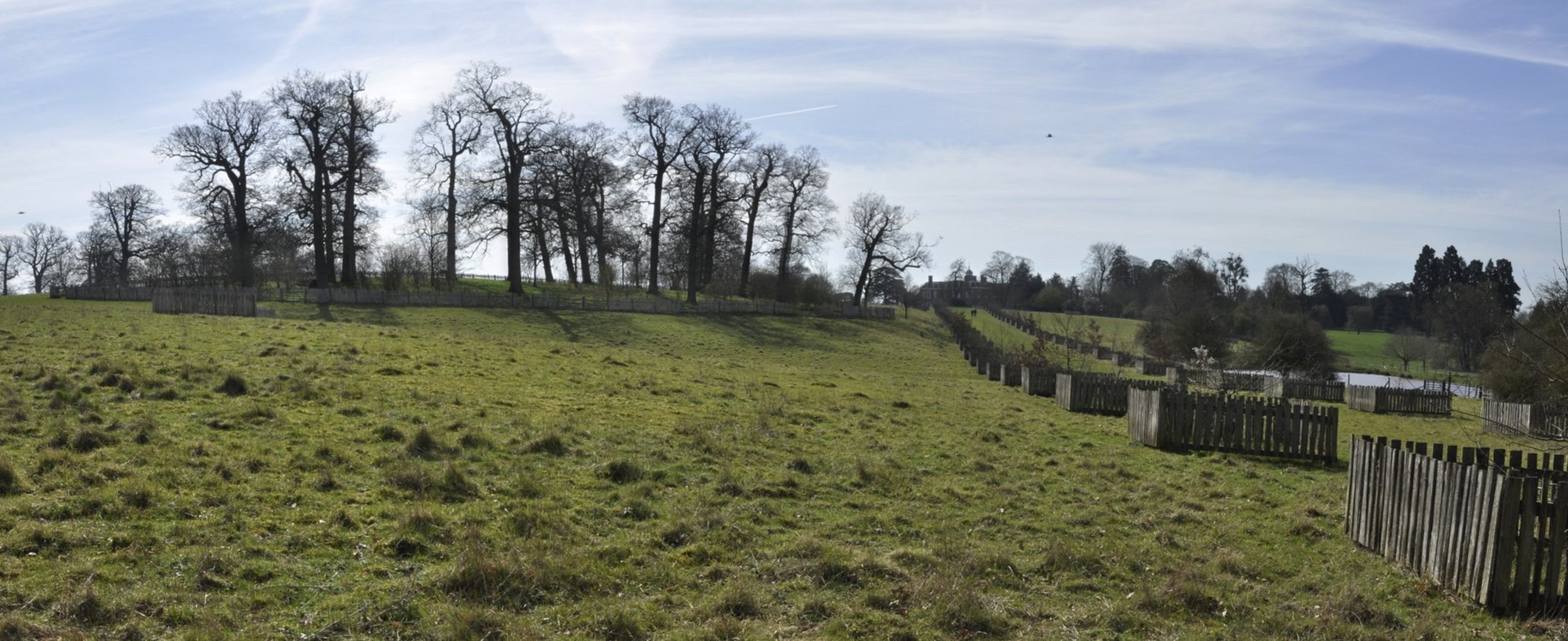
7 June, Cave City – Troy, IL, 367 miles
The Mammoth Cave National Park opened at 08:00, and we were at the Visitor Center not long afterwards. I had booked a tour of the Frozen Niagara cave some months back, at 09:20. This was a guided tour, the first of the day, and to a cave that was easily accessible. I didn’t want to contend with scrambling over rocks with my leg. In any case we planned to stay at the Park only until late morning as we still had the whole day’s trip of over 350 miles to make.
We enjoyed the cave, along with a group of fewer than 30 others. The caves are kept closed and it’s generally not possible to visit them alone. What amazed us is that the cave system, at over 440 mapped miles is the largest system in the world. The Park gets very busy during school holidays, and we were fortunate to have visited when we did.
Our next port of call was Fort Defiance at the confluence of the Ohio and Mississippi Rivers, and the southernmost point of Illinois. Most impressive.
That’s the Ohio River behind us and the bridge between Kentucky and Illinois . . .
At Fort Defiance, at the southernmost tip of Illinois, at the confluence of the Mississippi and Ohio Rivers
Then we followed the Mississippi north towards St Louis and our hotel in Troy just northeast of the city, catching a glimpse of the famous Gateway Arch as we skirted the city center on the Illinois side of the river.
8 June, Troy – Iowa City, IA, 332 miles
Our plan was to follow the Mississippi north through Missouri into Iowa. Heading west around the north of St Louis we crossed both the Mississippi and Missouri Rivers close to their confluence. Heading north on MO79, we stopped at Clarksville to stretch our legs, and look at the dam and lock, where a very large combination of barges was being ferried northwards slowly against the current.
Further north we stopped also at Louisiana, MO to view the Champ Clark Bridge that connects MO and IL, from a vantage point high above the river.
Then it was on to our next, and last, overnight stop in Iowa City.
9 June, Iowa City – St Paul, MN, 333 miles
Our last day on the road, heading north on very straight roads, before crossing into southern Minnesota and crossing the Bluff Country eastwards to reach Winona on the Mississippi.
Just south of the Iowa-Minnesota state line we passed through Cresco, IA which proudly advertises itself as the birthplace of Dr Norman Borlaug, father of the Green Revolution in wheat and Nobel Peace Prize Laureate in 1970, who I had the honour of meeting when I worked at IRRI.
In Winona, we took a short diversion to a scenic overlook about 500 feet above the river valley and had a spectacular view north and south.
Then we set off with added determination to arrive to Hannah and Michael’s in the Highland Park area of St Paul by late afternoon, and the end of our enjoyable 2017 road trip adventure.
Here are the individual blog posts about the various places we visited:
Just over seven weeks ago, on a sunny early April morning, we headed west from our home in Bromsgrove in northeast Worcestershire, to visit the National Trust’s Berrington Hall in Herefordshire, about 8 miles due south of Ludlow (that’s in Shropshire).
Yesterday, on what was probably the hottest day of the year so far, and without a cloud in the sky, we headed in the same direction, to another National Trust property, Croft Castle and Parkland, just five miles northwest of Berrington Hall. This was our second visit; Croft Castle was one of the first properties we visited in June 2011, just after becoming members of the National Trust.
The main entrance of Croft Castle, and the Church of St Michael
What is particularly remarkable is that Croft Castle has been the home of the Croft family for about 1000 years, and was listed in the Domesday Book in 1086. The Croft family has made many contributions to the annals of British history, under the Plantagenets, during the 15th century Wars of the Roses, Tudor and Elizabethan England, the Civil Wars of the 1640s, and through to recent decades. The Croft baronetcy was created in 1671. The castle itself is a somewhat eclectic mix of architectural styles that reflect its long history.
South face
South face
Corner of south and west faces
West face
Much of the interior has an 18th century feel, although some of the rooms on the ground floor must have been used as family rooms when the Croft family were in residence continually. Today the family retains some rooms on the first floor, not open to the public. In fact, during our visit there was only one room on that floor open, the Ambassador’s Room overlooking the main entrance, that has been ‘returned’ to its First World War decor.
Just opposite the main entrance to the castle stands the small church of St Michael. Inside, there is the grand tomb of Sir Richard Croft and his wife Eleanor. Sir Richard fought at the Battle of Mortimer’s Cross, just a few miles away from Croft Castle, in 1461 on the Yorkist side. He later became a high ranking member of the household of Henry VII (who usurped the throne at the Battle of Bosworth Field in 1485, defeating King Richard III, and establishing the Tudor dynasty).
The castle is surrounded by some 1500 acres of parkland, and the National Trust has set out some well marked walks for visitors to follow. We basically took the Blue walk up to the Iron Age fortress of Croft Ambrey (that dates from about 550 BC), covering almost 4 miles before we returned to the car park, a well-deserved sit down, and picnic lunch under the welcome shade of the magnificent beech and oak trees surrounding the castle.
The Blue walk passes through a grove of pollarded Spanish chestnut trees (panted in the late 16th century) that are said to have come from ships of the failed Spanish Armada.
The 360° views from Croft Ambrey are truly stunning: south to the Black Mountains of South Wales; east to the Malverns in Worcestershire; northwest to Clee Hill; and west into the border hills between England and Wales. The climb (not steep) to the summit is really worth the effort. Despite the heat of the day, there was a pleasant breeze taking the edge off it.
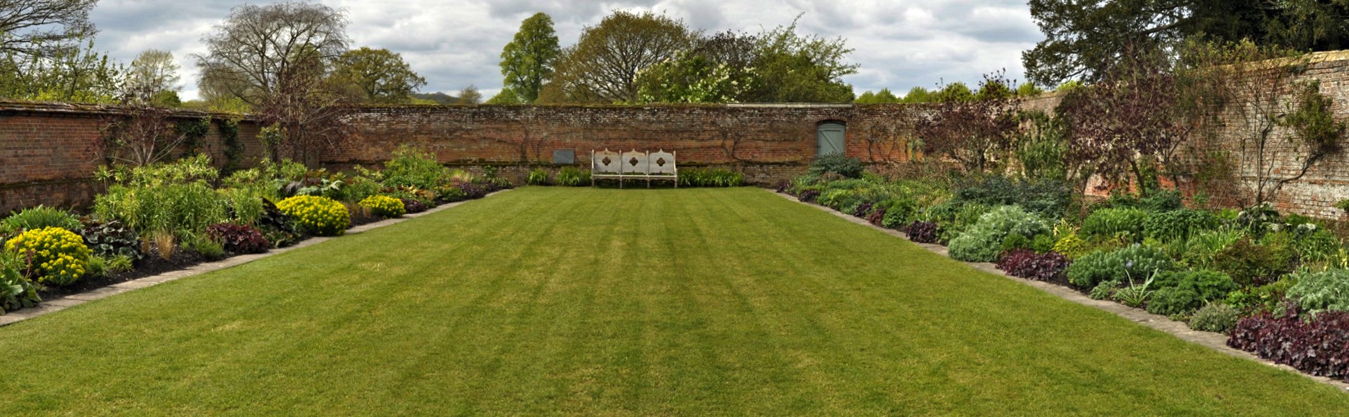
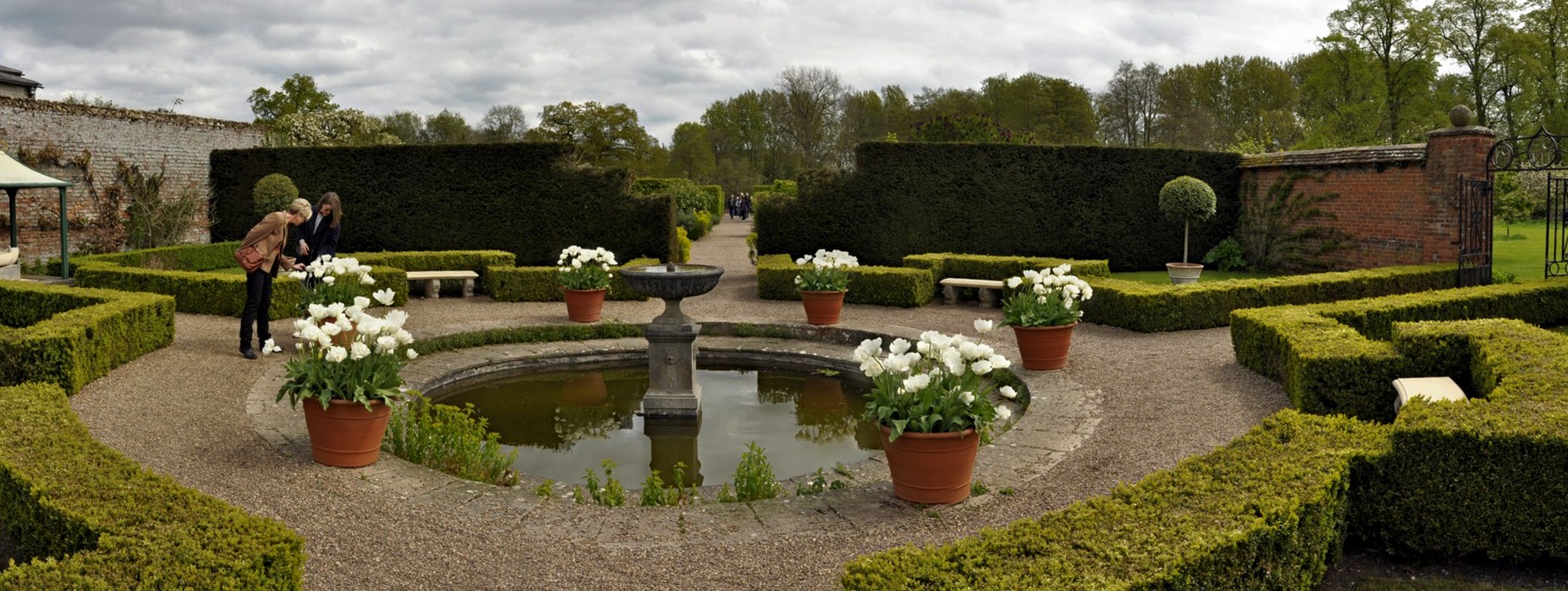
Croft Castle has a particularly fine walled garden, and a glasshouse area. The garden covers some six acres, with many rows of vines in its northeast corner. Having now visited quite a number of National Trust properties, my wife and I are in agreement that this walled garden must be one of the nicest in the Trust’s portfolio.
Since our first visit in 2011, the National Trust has made a number of operational changes to how it manages the property. There is now a free flow for visitors through the house, and photography is permitted throughout. In 2011 I was told off—in no uncertain terms—by one of the volunteers for deeming to take a photo of some panelling detail. The Trust is much more relaxed about photography nowadays, except where there are restrictions (for personal family or copyright reasons) at some houses.
The Hall
The Library Anteroom
The Library and Turret Room
The Drawing Room
The Blue Room
The Oak Room
The Dining Room
The Staircases, Gallery, and Courtyard
The Ambassador’s Room
No such problems yesterday. The staff were most welcoming, particularly the lady who greeted us at the main entrance. The tea room appears to have been expanded, and the toilets have been upgraded – clean as ever at National Trust properties. Last time there was a water shortage, and visitors had to queue up to use portaloos!
Croft Castle is just an 83 mile round trip from home – almost one of our local National Trust properties. Perhaps it does not yet have the finest collection of furniture and paintings (compared to many others), but the rooms have a homely feel. And the parkland of course is stunning, with space for everyone to enjoy. The walled garden is Croft’s ‘jewel in the crown’. Well done to the two full-time gardeners (assisted by volunteers, of course) who keep this garden so well maintained.
3 September 1651. Just over 33 months since his father, Charles I, had his head removed from his shoulders on a scaffold outside Whitehall in London, the young Charles II (not yet crowned king) was on the run. A fugitive. His plans to defeat the Parliamentarians under Lord Protector Oliver Cromwell had come to nothing. Superior forces of Cromwell’s New Model Army had defeated the Royalists at the Battle of Worcester, bringing an end to the Civil War.
Charles had to escape, but how to return to France and safety? His escape route took him north through Worcestershire (close to where I live, some 13 miles north of Worcester), and through Staffordshire and Shropshire to reach Boscobel House. The Boscobel estate straddles the Staffordshire-Shropshire county boundary (map).
In 1651, Boscobel House was a hunting lodge in the forest. Charles found refuge there, not only hiding in a priest hole overnight, but also among the canopy of a large oak tree (the famous Royal Oak) close by, as Parliamentarian forces searched high and low for him. He was also hidden at nearby Moseley Old Hall (about 10 miles due east of Boscobel, now in the hands of the National Trust, and which we visited in April 2014).
Boscobel House and the nearby White Ladies Priory (which was a converted residence when Charles sought refuge there in 1651) now belong to English Heritage. Yesterday, we made the 45 mile trip north to visit these two sites, and another English Heritage property, the ruins of Lilleshall Abbey, just over seven miles northwest from Boscobel.
Boscobel House and The Royal Oak The house has Tudor, 17th century and Victorian extensions. The farmyard buildings are Victorian. It was owned by the Giffard family who lived at White Ladies Priory. The lonely Royal Oak that stands in a field a short distance from the house is a descendant of the original tree in which Charles hid.
(1) Hunting Lodge; (2) Garden; (3) Cowhouse; (4) Stables; (5) Dairy display; (6) Smithy; (7) Family room; (8) White Ladies Priory – about 1 mile, 20 minutes walk; (9) Royal Oak – approx 5 minutes walk.
To the left is the dairy, with the Tudor and 17th century hunting lodge in the centre. The Victorian wing is on the right, painted in black and white to represent a half-timbered Tudor construction.
The Victorian extension.
The knot garden and 17th century hunting lodge.
The Tudor entrance hall.
The parlour
There is a contemporary text about the ‘visit’ of Charles II to Boscobel on display in the parlour.
A tapestry on the wall of the Oratory just off the parlour.
This 17th century portrait hangs above the fireplace in the Oratory.
The knot garden from the Oratory.
The priest’s hole from the Squire’s Bedroom.
The priest’s hole in the attic where Charles II hid for one night.
What special events occurred 1967? The BBC made its first TV broadcast in colour, and set up BBC Radio 1, 2, 3 and 4; the QE2 ocean liner was launched on the River Clyde; singer Engelbert Humperdinck had several top selling singles of the year; and The Beatles released the iconic album Sgt Pepper’s Lonely Hearts Club Band.
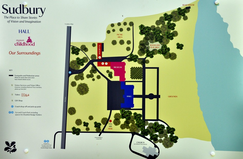
These were just a few highlighted on little signs either side of the footpath from the car park to Sudbury Hall, a National Trust property in Derbyshire, just north of the Staffordshire-Derbyshire boundary, the River Dove (see map).
But, as we reached the end of the footpath, we encountered the important ‘Sudbury’ fact. Occupied by the same Vernon family since it was built in 1660 by wealthy London merchant George Vernon, Sudbury Hall was bought by the National Trust when the Vernons were forced to relinquish ownership in order to meet death duty liabilities. The Sudbury Vernons were distant cousins of the Vernons of Hanbury Hall (the closest National Trust property to our home in Worcestershire).
Sudbury Hall is a Restoration architectural paradox, idiosyncrasy even: an exterior that harks back to an earlier Jacobean period, disguising sumptuous interiors more typical of the 1660s and early 18th century.
Adjacent to the hall is the Parish Church of All Saints in the Diocese of Derby, with some lovely stained glass windows, and impressive memorials to various generations of Vernons.
The hall is aligned west-east, with the main entrance on the north side. While it has a layout of an earlier building, a large entrance hall, even a long gallery on the first floor facing south, nothing quite prepares you for the flamboyance of the staircase (in the northwest corner), the ceilings and decorations of the saloon and drawing room(s) on the ground floor, and those of the long gallery.
Although George Vernon employed local craftsmen in much of the construction of Hanbury Hall, he did seek out some of the most talented to realise his vision of ‘the good life’.
Much of the plaster ceiling work was carried out by London craftsmen Robert Bradbury and James Pettifer. This is what I found about Bradbury and Pettifer on the website of the Woodcarvers Guild Ltd:
Two London plasterers of this period – the 1660s – whose work was similarly accomplished, were Robert Bradbury and James Pettifer. We know Pettifer trained under the London plasterer Arthur Toogood, who was Master of the Plaisterers [sic] Company in 1663.
Their best work outside London is at Sudbury Hall, Derbyshire, where they plastered ceilings in 1675-6. These are densely and richly decorated wall panelling and oak panelling and deserve close attention. The house was begun for Mary Vernon in the reign of James I, but was far from finished when she died in 1622. It then stood empty as a partly completed shell until after the Restoration, when Mary’s great-grandson, George Vernon, completed it. In doing so, he had the good sense to use excellent carvers, plasterers and painters.
In 1675-6 Bradbury and Pettifer provided the ceilings of the drawing room, the parlour, the staircase hall, the well, the Queen’s Bedroom and that of the 138-ft long gallery. They charged at the rate of 6s a yard and whilst to some eyes their decorations are florid and all-enveloping, the exuberantly fashioned wall panelling and oak panelling ornament was at least confined to the spaces provided in the design. Just enough was allowed to stray beyond the limits set down by the moulded ribs to give a natural effect. In fact, the delicate swirling work, most of it moulded but carefully arranged so that it appeared to consist of many different parts, was positioned with such skill that Laurence Turner wrote in his book on decorative plasterwork in 1927 before the discovery of the accounts, ‘the four well modelled amorini in the corners of the [staircase] cove [are] evidently by an Italian modeller, for no English plasterer could have developed so suddenly the ability to model the human figure …’ In the seven compartments of the long gallery ceiling and its frieze, there are curling flowers and foliage, shells, emperors’ heads, horses galloping from cornucopias, and dragons and wild boar in unlikely proximity to each other. Exquisite wood carving is everywhere.
In the Saloon, family portraits are set in panels carved by Edward Pierce (or Pearce), who also carved the balustrade on the magnificent Great Staircase. The ceiling panel in the saloon and elsewhere are paintings by Louis Laguerre in the Baroque style, which were commissioned by George Vernon a couple of decades later.
The Entrance Hall Somewhat reminiscent of a medieval hall, Sudbury’s entrance hall has a stone flagstone floor, and stone arched doorways. The walls are covered by several full length portraits. And on three tables are seven exquisite Sèvres porcelain figurines dating to 1860, depicting a boar hunt.
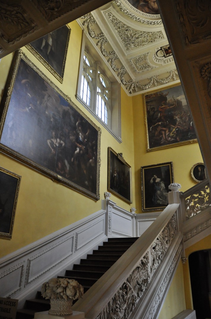
The Great Staircase Leaving the Entrance Hall, nothing quite prepares you for the magnificence of the staircase, from floor to ceiling, with its intricate carving (apparently in lime wood, and painted white), the paintings on the walls, and the elaboratelydecorated ceiling. It must rank as one of the most impressive that we have seen in any of our National Trust visits.
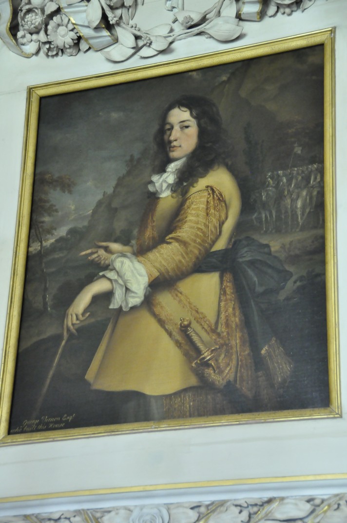
The Saloon An elaborate doorway (mounted with a bust that looks suspiciously like William Shakespeare), you enter the saloon, a room with life-size portraits on all walls, and a smaller painting of the hall’s creator, George Vernon, above the door.
The Long Gallery This came as a complete surprise. Long galleries were typical of much earlier houses. At Sudbury it extends the whole length of the house and faces south overlooking lawns and the lake. The quality of the plaster work is unparalleled. Currently there is little furniture on display, but at the east end is a beautifully painted 17th century Flemish cabinet with biblical scenes, by Frans Francken II. The frieze around the walls is punctuated by various images, and that on the west wall is apparently of King Charles II. Off the long gallery is a small library, with its own gallery. This opens on to the top of the staircase, and passes right into the Queen’s room.
The Queen’s Room Over the two doorways are almost identical paintings, almost certainly Dutch, depicting contemporary flowers and fruits. The fireplace is pretty impressive.
Drawing Room(s)
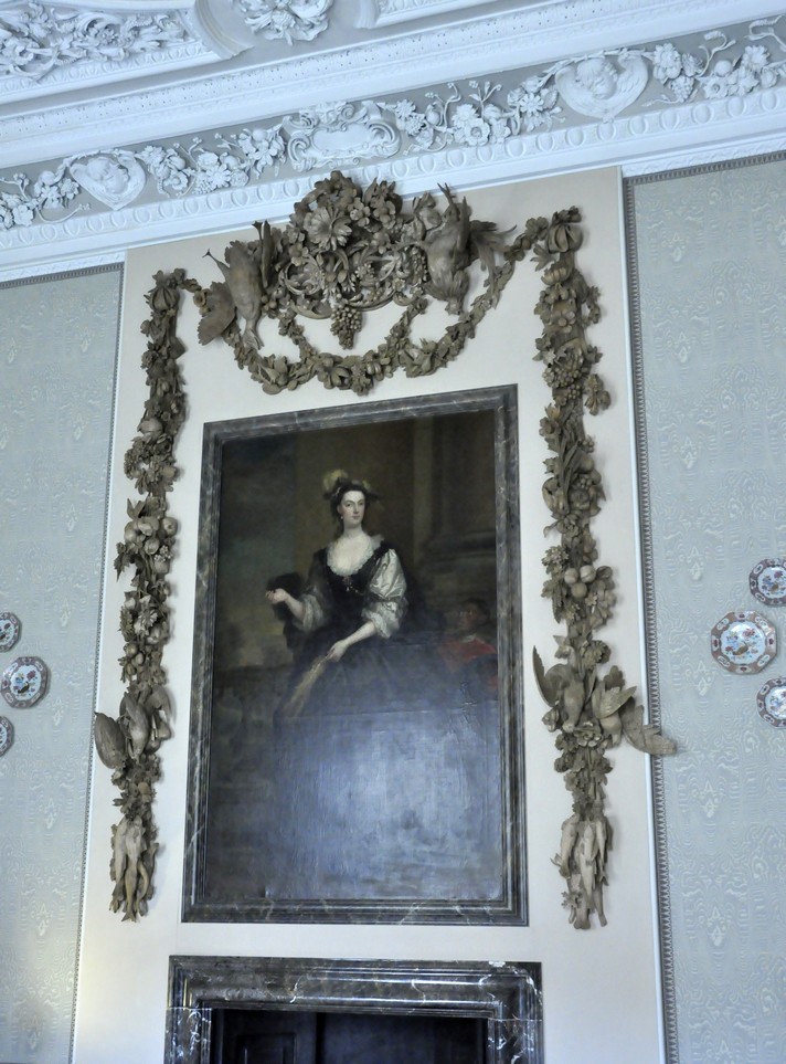
I’ve left the pièce de résistance until last. Leading off the saloon is the drawing room, now divided in two, according to the original 17th century floor plans. It was opened into a single rooms during the 19th century. And why is it the pièce de résistance? Surrounding a full length portrait of a lady is an intricate and quite magnificent wood sculpture, depicting all manner of plants and game animals, carved by renowned Dutch-British sculptor Grinling Gibbons.
This is a special carving. But who was the favored lady? Someone special (nod, nod, wink, wink)? This is indeed a remarkable tribute to someone near and dear. If I remember correctly what one of the volunteers told us, she was the sister-in-law of the wife of George Vernon.
Although the National Trust has owned Sudbury Hall for 50 years (and first opened to the public in 1972), refurbishment of the interior is still a ‘work in progress’. Most of the rooms are still lacking furniture. In this respect, the property reminded me of another National Trust property, Dyrham Park near Bath that we visited in August 2016. Not only had Sudbury Hall to be made safe, but decisions were taken—and still being taken—on how to redecorate each of the rooms. And decisions taken are not to everyone’s approval, as the obituary to the 10th Lord Vernon (referenced earlier) indicates.
A Museum of Childhood was opened at Sudbury in one of the extensions to the hall. This is a separate entrance to the hall. We enjoyed an interesting 45 minutes viewing all the exhibits bringing back memories of our childhoods, particularly with the various books and toys on display, and also from our daughters from 1978.
In the 1950s and early 1960s I used to pass in front of Sudbury Hall from time-to-time, travelling with my parents from our home in Leek to visit my father’s sister who lived just beyond Burton upon Trent. Until the early 1960s, my paternal grandparents lived in the village of Hollington, just a few miles north of Sudbury. This is Jackson-Bull home territory. In those days the main road, much quieter then, passed immediately in front of the hall. Now, the hall and village of Sudbury are fortunately by-passed, but there is nevertheless a continual roar of traffic from nearby and very busy A50 from Derby to Stoke on Trent.
It was a bright and sunny day when we visited Sudbury last week, but with a biting northerly wind. Nevertheless, our visit to Sudbury Hall was a delight, and quite unexpected in terms of what we saw. The volunteers were most helpful and knowledgeable, adding to the enjoyment of our visit. Sudbury Hall is definitely worth a visit if you are in the vicinity—and even if you are not.
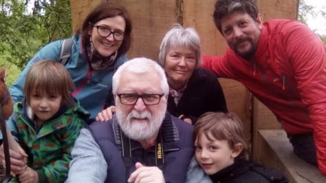
Last weekend, our younger daughter Philippa and her family came down from Newcastle for the Bank Holiday. A few days ahead, she asked us if we knew of or had visited any bluebell woods close to home. Apparently, Elvis, her elder boy (who will be six at the end of September) had told her that bluebells were his favourite flower and wanted to see some growing in the wild. Maybe his teacher had been talking about them recently.
L to R: Felix, Philippa, me, Steph, Elvis, and Andi
Steph and I have been members of the National Trust for several years now, and we’ve had hours and days of enjoyment. Regular readers of my blog will know that I usually write something after a visit to one of their properties, the most recent being a visit about three weeks ago to Berrington Hall in Herefordshire.
There are three NT properties quite close to our Bromsgrove home: Hanbury Hall (our ‘regular’), Croome Park (a little further south, near Worcester), and Coughton Court, just 10 miles away in Warwickshire, east beyond Redditch. And each has its bluebell wood. But the one at Coughton is just a little special, composed almost in its entirety of the native English species, Hyacinthoides non-scripta. Very little if any of your invasive Spanish bluebell (Hyacinthoides hispanica) here.
The bluebell is such an iconic woodland species. Just imagine that blue carpet spreading under the wood’s leafy canopy. And at Coughton, the bluebells are mixed in places with cow parsley (Anthriscus sylvestris) and red campion (Silene dioica).
The native bluebell’s future is threatened in many places because of the spread of the Spanish bluebell that is widely grown in gardens. When garden waste is dumped irresponsibly then bulbs can be discarded as well. It hybridises readily with the native species, and once that has happened, stands of native bluebells are irrevocably changed.
We arrived at Coughton just on 11:00 (opening time) and the car parks were already filling up. I think everyone had the same idea: a walk through the bluebell wood, around the gardens, or the various walks around the estate. We made our first visit to Coughton Court in 2013, and then again in June last year when I was recovering from my accident.
Our walk took us around the bluebell wood, along the River Arrow (lots of ramsoms here, Allium ursinum), around the bog garden that is just beginning to come to life (the Gunnera will be spectacular later on in the season, although it and other plants had taken a slight hit from a frost overnight), and finally round the walled garden.
And for little boys, there were plenty of opportunities for fun besides looking at—but not picking—bluebells.
In front of the entrance to the hall the gardeners had planted a beautiful display of tulip beds, and along the newly-raked gravel paths around the lawn, the trees stood like soldiers at attention, having received a recent ‘haircut’ in readiness for summer visitors.
Why, for example, would a group of carrion crows be known as a murder of crows? Then there’s a parliament of rooks, a mischief of magpies, and a train of jackdaws. Often there is more than one collective name, depending on local tradition and usage.
Isn’t it delightful? Just goes to show how colourful the English language can be.
Well, here are the four culprits, and three of them (magpie, carrion crow, and jackdaw) are becoming increasingly common—and noisy—in our suburban garden in northeast Worcestershire. Greedy magpies regularly visit our bird table; crows and jackdaws tend to shout at us from the surrounding roof tops.
Rooks have taken up residence in a small copse alongside the busy A38 by-pass less than a mile away.
Carrion Crow
Jackdaw
Magpie
Rook
Members of the crow family are large and quite striking birds, and rather intelligent. From time-to-time we see jays in the surrounding countryside. But as they are solitary compared to the other four already mentioned, I don’t think I’ve ever seen a scold of jays. The jay is a really handsome bird.
Three other corvids, the raven (a conspiracy), chough (a chattering) and hooded crow ( a MacMurder perhaps, as they are found in Scotland) are much more restricted in their distributions in the UK. I’ve only seen them on a few occasions. Once seen, the chough is never to be forgotten, with its shiny black plumage, reddish-orange curved beak, and legs and feet of the same colour.
So, this morning when I went outside to put some last minute pieces of rubbish in the bin before collection, there was this solitary crow letting rip at the top of its voice, giving me chapter and verse. And that got me thinking about how common they have become, but also the lovely collective nouns we employ to describe them.
Then, being an active member of the blogging fraternity, I did wonder what a collective noun might be. I came across a click of bloggers in one blog; here is a more extensive list of suggestions. Which one would you choose?
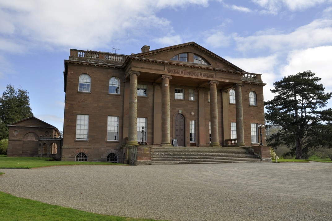
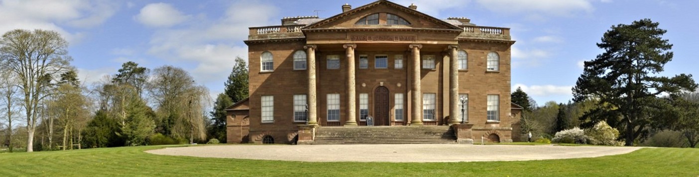
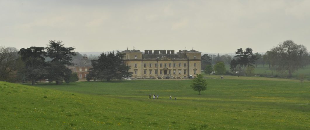
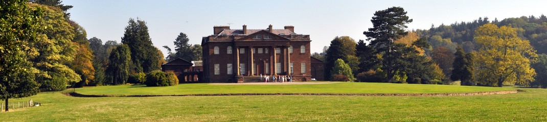
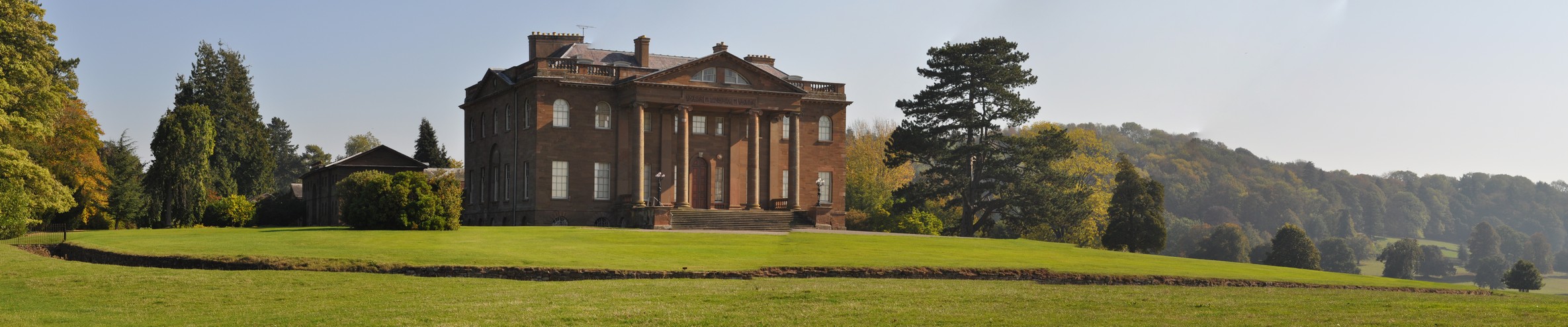
This is how the National Trust describes Berrington Hall, a late 18th century sandstone Neo-classical mansion overlooking the rolling Herefordshire landscape a few miles north of Leominster (see map). Designed by London architect Henry Holland, Berrington Hall was built between 1778 and 1781 for Thomas Harley.
Thomas Harley, by John Hall, after Henry Edridge, stipple engraving, late 18th century.
The estate also has a particular claim to fame. The park was the last to be created by landscape designer Lancelot ‘Capability’ Brown (who was also Henry Holland’s father-in-law).
Last Tuesday, Steph and I made our second visit to Berrington; we were first there in September 2011, the year we joined the National Trust. It was a beautiful day then, as it was this week. The weather forecast had promised a better day if we travelled westwards. Berrington Hall is 37 miles almost due west, and a little over an hour by road, from Bromsgrove in north Worcestershire.
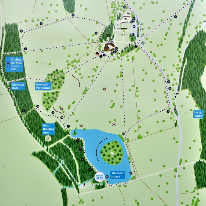
We arrived not long after 10:30, and already the car park was quite full. After heading off to the tea room for a refreshing cup of coffee, we enjoyed a long walk around the park before heading back to the car for a quick picnic lunch, and then into the house itself.
We followed the route due south of the house towards and around the bottom of the lake, past the Boat House, around George’s Plantation, and back to the house.
Berrington Hall is not large compared to some 18th century mansions we have visited. Indeed it is quite modest, somewhat austere in appearance. But it sits so comfortably in its landscape, facing southwest, that it was always meant to be there. Eighteenth century landowners and their architects certainly knew just where to begin construction to the best effect.
A grand Triumphal Arch now hosts the National Trust entrance office, and a driveway approaches the house from the rear, before circling around the front of the house to reveal a majestic portico supported on four large pillars, strategically spaced never to block any of the windows.
As was Capability’s intention, the house is best seen from different advantage points in the park, as is the park from the steps of the house.
Brown knew how to exploit the view of the parkland from the house to best effect. It was no laughing matter. He placed a ha-ha just in front. A ha-ha is ‘a recessed landscape design element that creates a vertical barrier while preserving an uninterrupted view of the landscape beyond. The design includes a turfed incline which slopes downward to a sharply vertical face, typically a masonry retaining wall. Ha-has are used in landscape design to prevent access to a garden, for example by grazing livestock, without obstructing views‘.
The ha-ha at Berrington is one of the finest. The landscape just floats away, uninterrupted, from the house, the only evidence of its presence being a change in colour between the short grass of the terrace and the fields beyond, that is clearly seen in the video clip below.
On the rear of the house is a courtyard, a stables block (with clock), a dairy, and laundry. Most of the buildings now accommodate facilities for visitors: the tearoom, toilets, a shop, and the like, as well as offices.
This is the dairy, with the entrance at the end of the building. Access to the courtyard is just beyond the end of the building.
The door of the dairy.
Dairy floor.
The walls of the dairy are covered in beautiful tiles.
The rear of the house.
The outside wall of the stables block.
Emerging from the stables into the courtyard.
Clock above the stables.
The laundry.
Inside the house, the atmosphere is one of restrained elegance. None of the rooms is particularly large, unlike many other houses we have visited. Nevertheless, there are flashes of flamboyance: in the mouldings around the doors, on the architraves, and particularly the ceilings which are most elaborately sculpted and painted.
The staircase, and the first floor landing surrounding the staircase on three sides, is rather stunning, all marble pillars reflecting the natural light from the cupola.
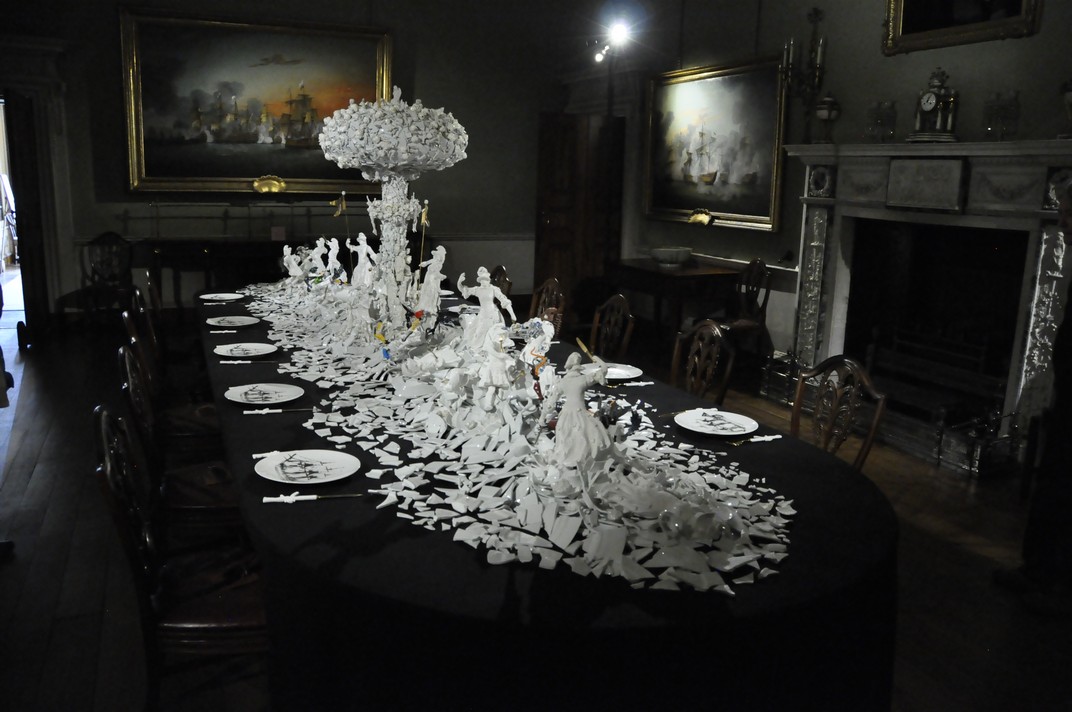
We encountered our biggest surprise, however, when we entered the dining room on the ground floor. In September 2011 the dining table was laid out as though dinner was about to be served. On the walls are paintings reflecting the battles of Admiral Lord Rodney, whose son, George, married Anne, the daughter of the man who built Berrington Hall, Thomas Harley. On his death, Berrington passed to the Rodney family.
On this visit, the room was almost in darkness, with just spotlights focused on a sculpture, War & Pieces, that extended the length of the table. Created by Dutch artist, Bouke de Vries, this is how the sculpture is described in the National Trust brochure:
War & Pieces is a striking piece, nearly six metres in length, inspired by the grand seventeenth century sugar sculptures found on the dining tables of the wealthy. By the early eighteenth century, sugar had been replaced by exquisitely crafted porcelain depicting allegorical, classical or architectural scenes that displayed the host’s wealth and taste at their banquets.
Between the eighteenth and nineteenth century, it became popular for banquets to be held for generals and their officers on the eve of great battles.
War & Pieces is an envisioning of one of these war banquets showing deconstructed porcelain figures engaged in a deadly struggle with a giant central mushroom cloud composed of skulls, ‘frozen Charlottes’ (a nineteenth century mass produced child’s toy) and presided over by figures of the crucified Christ and Guanyins, the Chinese goddess of compassion.
The piece is composed of broken antique porcelain and glassware, as well as parts of plastic children’s toys and sugar, bringing together the notions of modern warfare and art with those of the eighteenth and nineteenth centuries and making us reconsider our perceptions of beauty and the usefulness of broken objects.
War & Pieces
The scene of war on the table is echoed by the maritime battles depicted on the walls by Thomas Luny (1759-1837). Admiral Lord George Brydges Rodney (1718-1792), the naval hero of The Seven Years War and the American Wars of Independence, is celebrated in these paintings. Rodney was the youngest captain in the British navy and is, arguably, the tactician who first attempted the manoeuvre called ‘breaking the line’ which was used to such great success in later British naval victories. At Berrington, his grim engagements with the French and the Spanish upon his ninety gun ship of the line, The Formidable, in the 1780s are highlighted by Luny’s paintings. The Formidable is the ship depicted on the plates on the dining table that surround War & Pieces.
The handles of the knives are shaped like AK-47 rifles! Comments in a visitors’ book reflected the wide expression of opinions about this sculpture. I thought it was an inspiring commentary on the futility of conflict.
Berrington also has a large walled garden, planted with heritage apple trees that I have commented on and illustrated elsewhere in this blog.
All in all, a very pleasant second visit to Berrington. And it would be remiss of me to finish this particular account without mentioning the extremely friendly staff and volunteers who contributed to our overall enjoyment. The two ladies in the ‘dressing-up room’ on the first floor kept us entertained with their descriptions and demonstrations of the intricacies of 1770s and 1805 fashions!
Majestic. Standing proudly in the landscape, silhouetted against a bright Spring sky. Many preparing to burst forth with that first flush of greenery that heralds the oncoming summer. Others, still standing, but unlikely to remain that way for much longer. The sap no longer rises as it once did. They will fall where they stand or—more likely—felled as a potential hazard to the public.
Others lie on their sides, like beached ships, slowly rusting away, a pathetic shadow of their former glory.
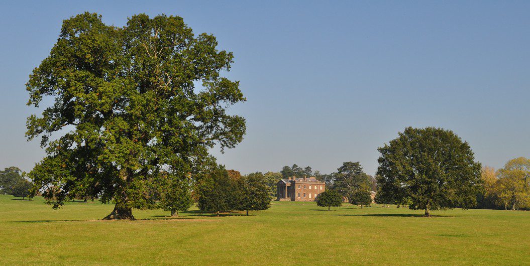
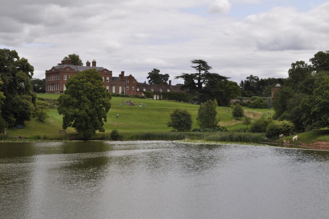
These are remains of an Oak Plantation planted in the 1720s at Hanbury Hall, a magnificent early 18th century house now owned by the National Trust, just seven miles from our home in Bromsgrove in northeast Worcestershire. A few hundred meters away from these oak trees stands the hall, overlooking a parkland outside the surrounding ha-ha, that the original builder of Hanbury, Thomas Vernon would never have seen. Designed by George London, what we experience today at Hanbury, three hundred years on, as is the case at similar ‘stately homes’ across the country, was just merely a vision in his mind’s eye.
The Hanbury Ha-ha and park
So many who commissioned great houses, gardens, and parks died before their dreams were realised, and long before their visions of a transformed landscape could be appreciated to the full. Only third or fourth generation custodians perhaps would have really begun to appreciate what was originally intended when the house, gardens, and park were laid out. In the beginning each would have been a massive building site and earthworks, and a nascent park with saplings dotted around and about.
Take the exploits of Capability Brown for example, who was responsible in the mid-18th century for the transformation of so many natural landscapes nationwide. Croome Court, southeast of Worcester (and about 15 miles due south from Hanbury), was his very first commission, for the 6th Earl of Coventry, and the ‘river’ that was excavated by hand alone took 12 years to complete. Some of the trees that Brown planted can still be seen at Croome today.
Croome Court
Steph and I have now visited quite a number of National Trust properties throughout England (and Wales) and this idea of vision and imagination is strongly reinforced by examples such Stowe in Buckinghamshire and Berrington Hall in Herefordshire, Calke Abbey in Derbyshire, Dudmaston Hall in Shropshire, and Dyrham Park in Gloucestershire, besides Hanbury and Croome.
Stowe
Berrington Hall
Calke Abbey
Dudmaston
Dyrham Park
A more recent (150 years ago) example is Cragside, near Rothbury in Northumberland, built in the the late 19th century by William, 1st Baron Armstrong and his wife. The mock-Tudor mansion overlooks a wooded valley and one of the largest rock gardens in Europe, carved out of the rugged Northumbrian moorland. At Cragside, the Armstrongs planted more than seven million trees. Today, the house nestles comfortably in this landscape, seemingly for all time.
The tradition of landscape renewal continues under the National Trust. At Hanbury, for example, there are young saplings all around the park, protected (presumably against grazing by deer, maybe sheep) by picket fences. Impressively, the Trust is also recreating the Long Walk leading downhill from the Hall in a northeasterly direction.
The Long Walk at Hanbury Hall, with George London’s Semicircle (of trees) on the left
However, these full effect of these recent plantings will not be realised for many decades to come. I applaud the continuation, by the National Trust, of this wonderful tradition of leaving something behind in the landscape, just as those who built and nurtured these magnificent properties did, centuries ago.
When I fell over last January and broke my leg, and was incapacitated for almost three months, I never thought that we would be able to get out and about for National Trust and English Heritage visits as we had in previous years. How wrong I was!
Once I’d been given the all clear to drive, around the end of March—and relying on my trusty walking stick—we managed to visit eleven National Trust properties (including four times to our ‘local’ Hanbury Hall), and to five run by English Heritage. I have indicated the distance from my home in Bromsgrove, although we visited some properties while we were on holiday in the south of England in July.
National Trust During our holiday in the New Forest we made a day visit to Corfe Castle, and on the way home a week later we stopped off at Kingston Lacy. Further on, we passed the entrance to Dyrham Park, north of Bath, but didn’t have time to visit then. So we decided to return later in August.
Not long after I gained my mobility, we visited three properties that are quite close to home, not to visit inside the houses, but to enjoy the gardens, and relax with a cup of coffee or a bite to eat for lunch. The restaurant at Packwood House, renovated over the past couple of years or so, is particularly nice.
If I wrote a specific blog post about each of these visits, I have included a link below.
Hanbury Hall (10 April, 4 May, 29 August, and 18 November) 6 miles
Hanbury is our local National Trust property. I think we’ve been inside the house only once, several years ago, but during the year we did pop over there, in about 15 minutes, to grab a cup of coffee, and walk through the gardens. Of particular interest for me is the glorious parterre, kept immaculately by the resident gardeners and volunteers.
Shugborough Hall (22 June) 53 miles
One of the things we particularly liked about Shugborough was the number of rooms open to the public. As always the volunteers were most helpful in pointing us towards items of interest.
Avebury(2 July) 81 miles
We stopped in Avebury on the way south to our holiday in the New Forest. It was a good halfway place to have coffee and lunch. There’s much to see, with the stone circle and the house (with each room decorated in a different period).
Corfe Castle (5 July) 176 miles
We visited Corfe Castle on a day trip from our holiday home in Dibden Purlieu on the east of the New Forest. The drive west was about 47 miles, on quite busy roads.
Read about our visit to Corfe Castle and Kingston Lacy here.
Kingston Lacy(10 July) 134 miles
Kingston Lacy was owned by the same family as Corfe Castle, about 19 miles to the north. This must be one of the National Trust’s premier properties – it’s full of treasures. Well worth another visit sometime.
Kingston Lacy
Claydon (19 July) 67 miles
Our visit to Claydon was a delight. Normally, photography is not permitted inside the house, but when I explained that I write a blog about our National Trust visits, they gave me permission to photograph many of the architectural aspects I am interested in. And I have to say that the volunteers at Claydon were some of the most helpful and friendliest that we have come across.
Dyrham Park (12 August) 77 miles
It’s quite a walk from the car park to the house and gardens. Thank goodness for the shuttle service. On the day of our visit the weather was beautiful, and we thoroughly enjoyed our visit.
Brockhampton Estate (26 August) 25 miles
We made our first visit to Brockhampton in September 2012. It was great to see that other parts of the medieval house had been opened to the public.
Greyfriars’ House and Garden (14 December) 12 miles (by train)
This was our last visit for 2016, and we hopped on the train from Bromsgrove for the 20 minute ride to Worcester Foregate. From there it was a less than 10 minute walk to Greyfriars’. Nice to see the rooms decorated for Christmas, and we had an excellent tour guide.
English Heritage This was our second year as members of English Heritage, and we didn’t visit as many properties as we would have liked. But that will be rectified in 2017!
Buildwas Abbey (27 May) 36 miles
We had tried to visit Buildwas in 2015, on our way from Wenlock Abbey to Ironbridge. But it was closed. We had the place to ourselves when we visited in May. Peaceful!
Read about our visit to Buildwas and Langley Chapel here.
Langley Chapel (27 May) 11 miles from Buildwas Abbey
Standing isolated in a field, this is a delightful example of a 17th century chapel catering to a Puritan rural population.
Calshot Castle (9 July) 136 miles
Calshot was just a few miles south of our holiday home in Dibden Purlieu. We were amazed to discover how well it had been maintained over the centuries. I guess this is not really surprising considering the active defensive role it has taken on all that time.
Bolsover Castle (17 August) 90 miles
Bolsover Castle sits on the skyline to the east of the M1 motorway in Derbyshire. Whenever we travel north to visit our younger daughter Philippa and her family, we have to pass Bolsover. And for years we were intrigued by it, and what it might offer. We had also seen in the past few years a BBC program about the castle presented by historian Lucy Worsley. We were not disappointed in our visit.
Witley Court and Gardens (26 August) 16 miles
Witley Court is one of our local visits, just a few miles west of Bromsgrove on the far bank of the River Severn. We have been visiting Witley Court since the 1980s when you could just wander into and around the ruins. We had last been there in July 2015.
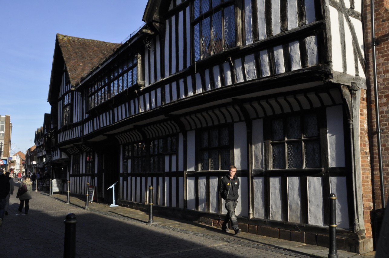
In Friar Street, close to the center of Worcester, and a couple of hundred meters or so north of its magnificent cathedral, stands a half-timbered building built around 1480 (the birth year of my 13th Bull great grandfather) that has been a silent witness to some of England’s pivotal moments in history, such as the Dissolution of the Monasteries during the reign of Henry VIII in the late 1530s, and just over a century later when King Charles II (although not yet crowned) was defeated at the Battle of Worcester in 1651, the last battle of the English Civil Wars.
These photos show the double gateway looking into the garden, and from inside to the street, as well as views of the rear of Greyfriars’ from the garden. Building a half-timbered house was, according to our guide, a little bit like piecing a jigsaw together. Which pieces fitted where? Well, symbols were embossed on matching pieces of timber and these can be clearly seen in one the photos in this gallery.
Greyfriars’ is a late medieval merchant’s house that has survived the ravages of time—but nearly didn’t make it. Greyfriars’ is now owned by the National Trust. We enjoyed a visit to Greyfriars’ House and Garden yesterday, where many of the rooms had been decorated to celebrate Christmas during various times: a Tudor Christmas in the entrance hall, a Puritan Christmas (or lack of it) in one of the main bedrooms, and a wartime Christmas in the library.
Just 13 miles of so south of our home in Bromsgrove, Worcester is the county town of Worcestershire. But for one reason or another, and despite having been residents of Worcestershire for over 35 years (albeit with a break of almost 19 years in the Philippines) we have only rarely visited Worcester. I think the last time I was there was in December 2013 when I was called for jury service at the Crown Court (but never actually made it on to a jury).
Since becoming members of the National Trust in 2012, in the lead up to Christmas we have visited one of the Trust’s properties in our ‘neighbourhood’ – Hanbury Hall, Croome Park, Packwood House, Baddesley Clinton or Coughton Court – since there is always a special festive display to enjoy.
This year we decided to visit Greyfriar’s, making the short journey by train, not wanting to have the hassle of finding convenient parking in the city. In any case, it was also an opportunity of experiencing Bromsgrove’s new railway station¹.
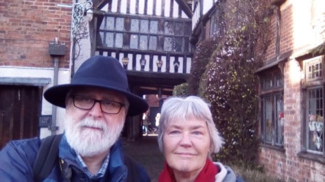
We stopped off for a coffee at M&S before walking on to Greyfriars’ and arrived just in time, a little after 11 am, to take advantage of the excellent first house tour of the day. We were just three visitors, and I had full opportunity to use my camera to the full, even though light levels were extremely low. So the set of photos I came away with are certainly not my best, by any stretch of the imagination, but I hope I did capture something of the beauty of this interesting property.
Saved from demolition
Greyfriars’ was destined to be demolished but was saved by members of the Worcester Archaeological Society. In 1943, military dental surgeon M Matley Moore and his sister Elsie took on the refurbishment of Greyfriars’, eventually taking up residence in 1949.
These photos show the main entrance hall, one of the main tapestries, and some of Elsie Matley Moore’s handiwork above the fireplace.
Apparently the house was in a dreadful state when the Matley Moores began their refurbishment project, and this was not something undertaken lightly during the Second World War or its immediate aftermath when building supplies were hard to come by. Nevertheless, they were able to salvage panelling and other decoration from other buildings, in addition to keeping what original features that were still part of the building’s fabric. Elsie Matley Moore was an accomplished seamstress, and lovingly restored a number of the seventeenth century tapestries that are still on display, as well as adding features of her own, such as ceramics and a set of particularly rare Georgian green (from arsenic? – not so) wallpaper panels in the downstairs living room.
These photos show the main bedroom (apparently occupied by the man of the house), the parlour (and its William Morris tiled fireplace), and the library. All the rooms had magnificent grandfather clocks, several manufactured in Worcestershire, and at least one designed with just a single hour hand. In the fireplaces in two rooms were cast iron – and painted – door stops that Elsie Manley Moore collected. These are quite rare today. Above the fireplace in the parlour is some original carved woodwork frieze with carved dragons (there’s a close-up in this gallery), and indicating that Worcester is not that far from the Welsh border country.
Downstairs, the dining room was refurbished in a Georgian style. These photos show the majolica tiles above the fireplace, and one of the green wallpaper panels.
The garden was obviously dormant yesterday, but National Trust volunteers told us that during the summer months the garden is a haven in the center of Worcester (although traffic noise from the close-by ring road did unfortunately intrude as we explored a few of the garden’s nooks and crannies).
Each year Greyfriars’ is host to Shakespearean players who perform in the garden. I think we should look out for that event for 2017.
_____________
¹ After the Rio Paralympics 2016, the Bromsgrove station signs were all painted gold, recognising the rowing gold medal won by local sportswoman Lauren Rawles.
L to R: Director General Tony Simons, Brian, Alice Muchugi, and me
Learning about trees
While I have visited ICRAF (the acronym for the institute’s former name, which is still used) a couple of times in the past, I had never visited the genebank, and was intrigued to learn more about the particularities of conserving tree germplasm for food and agriculture. And we were not disappointed.
ICRAF’s Genetic Resources Unit (GRU) is part of the Tree diversity, domestication and delivery science domain, and is managed by Dr Alice Muchugi. On its web site, it states that the GRU has a global role to collect, conserve, document, characterize and distribute a diverse collection of agroforestry trees, mainly focusing on indigenous species in all ICRAF working regions. The ICRAF seed bank in Nairobi and field genebanks in the regions ensure the supply of superior tree germplasm for research and conserve material for the benefit of present and future generations. The current aim of ex situ conservation activities at ICRAF is to be a world leader in the conservation of agroforestry tree germplasm and develop a global conservation system for priority agroforestry trees. Genetic resources databases provide information on agroforestry tree taxonomy, uses, suitability and sources of seed as well as details of the ICRAF agroforestry genetic resources collection. The Genetic Resources Strategy guides in ensuring that collections are conserved to international standards, encouraging quality research to fill information gaps and promote use, and sharing knowledge and germplasm to improve livelihoods.
The genebank holds more than 5000 accessions of some 190 tree species. Among the important species are the tallow tree (Allanblackia floribunda), the baobab (Adansonia spp.), and a whole slew of fruit tree species like mango.While many have seeds that can be stored at low temperature, others have short-lived or so-called recalcitrant seeds. Seed conservation is therefore quite challenging. Some species can only be maintained as living plants in field genebank collections at several sites around Africa and also in Peru. The conservation biology of some of the species is further complicated by sex! Some trees have separate male and female plants, known as dioecy. As you can imagine, this is a very important characteristic to know at the seedling stage, since it might take up to 25 years for a tree to flower. And it’s not much consolation for a farmer to discover then that he has planted only male trees. Knowing whether a seed or seedling is male or female is actually a rather important conservation objective.
Not only is the biology complicated for ICRAF’s genebank staff, seed size varies from the ‘dust’ of gum trees (Eucalyptus species) to fruits and seeds weighing a kilo or more. Many have very hard seed cases, and staff have to resort to garden secateurs to break into them, or even place a seed in a workbench vice and attack them with hammer and chisel! Because so few seeds are available for some species, the seedlings from germination tests are most often taken to the field nursery. In the following photos, Alice Muchugi and some of her staff explain how seeds are tested in the laboratory and stored in the genebank
My genetic resources experience is limited mainly to potatoes and rice, each of which presents its own challenges. But nothing like the scale of agroforestry species. It was fascinating to see how Alice and her staff are successfully facing these challenges.
The Genetic Resources Research Institute (GeRRI) of Kenya Brian and I took the opportunity of visiting the national genebank of Kenya, located at ‘at the former KARI Muguga South, 28 km from Nairobi, in Kiambu County. Muguga, located at an altitude of 2200 metres above sea-level, has a bimodal rainfall pattern and provides naturally cool temperatures that are conducive for genetic resources conservation‘. This was interesting for a number of reasons. We wanted to have a national perspective on the CGIAR genebanks program we were evaluating, but also to see how this national genebank was operating. The Institute Director, Dr Desterio Nyamongo, is also a Birmingham genetic resources alumnus, having studied for his MSc in the early 1990s (after I had left to join IRRI). I should add that Brian was the Course Director for the MSc course on plant genetic resources.
The genebank has more than 45,000 accessions of 2000 species, landraces and wild species, and aims eventually to cover the flora of Kenya. The comprises the usual facilities for data management, seed conservation, and cold storage units. We were very impressed with the program of the genebank, and it has engaged very actively in international agreements for the collection, conservation, and use of genetic resources. Its recent collaboration with Hyderabad-based ICRISAT has led to collections of sorghum, pigeonpea and finger millet in Kenya, and germplasm is now conserved in both the GeRRI and in ICRISAT’s regional genebank in Nairobi where it has already been evaluated for useful traits and selections released to farmers.
I had one small embarrassing moment as we were shown around the genebank. When introduced to one of the staff, Mr Joseph Kamau, he told me we had already met. My mind was a blank. In 1998, he had attended a training course at IRRI on morphological and agronomic characterisation of rice varieties, as part of the participation by Kenya in the IRRI-led (and Swiss-sponsored) Rice Biodiversity Project. There he is on the left in the second row.
Now, forages are another thing . . .
After Nairobi, Brian and I moved on to ILRI’s Addis Ababa campus. We had earlier visited ILRI’s headquarters in Nairobi, located a few miles west of ICRAF.
ILRI’s genebank has always been located in Ethiopia, and has a very large collection of forage species (legumes and grasses) important for livestock. It has almost 19,000 accessions of 1000 species. During our recent visit to Australia we heard about a strategy for the conservation of forage species that aims to rationalise the forages collection held at ILRI and CIAT in Colombia (that I visited at the end of July). Forages are complex to conserve. The breeding system for many is not fully understood, nor their tolerance of low temperature storage conditions. The strategy contemplates archiving some of the species, since it’s unlikely that they will be useful for agriculture, even in the medium-term.
The head of the genebank is Dr Jean Hanson, a seed physiologist by training, and another Birmingham alumna, both MSc (1973) and PhD. Jean and I received our PhD degrees at the same congregation in December 1975. Jean has tried to retire at least once, but was asked to return to her old position after her successor left ILRI after just one year. Nevertheless, Jean has her sights set on permanently retiring once the new genebank facilities in Addis are commissioned in 2017.
In managing a genebank, you sometimes have to make tough (even hard) decisions. I never expected to have to become hard-hatted!
But that’s exactly what we had to do during our visit, as Jean showed us round the impressive building that is being constructed around the existing cold store and will expand the conservation capacity significantly. It’s also interesting that the genebank and its collection will now be managed through ILRI’s Feed and Forages Biosciences program, whose new head, Dr Chris Jones is keen to use genomics to study and exploit the diversity in this important germplasm collection.
In these photos, Jean explained some of the complexities of seed increase in the greenhouse (these were Trifolium or clover species), and in the field where it’s often necessary to spatially separate different accessions to prevent cross pollination. She also showed us bar-coded samples in small refrigerators of the Most Original Samples – samples closest genetically to the germplasm collected in the field. We did go inside one of the cold stores after navigating our way through a construction site. Thus the hard hats for health and safety purposes.
This is an important investment by ILRI in its genetic resources conservation responsibilities, and is a great commitment for the future, based no doubt on the broader institutional support for genetic resources conservation through the Genebanks CRP (soon to become the Genebanks Platform).
I have just returned from Australia, a round trip of almost 21,500 miles, to attend the Annual Genebanks Meeting of the CGIAR’s Genebanks CRP. I was in Australia for only four nights! I travelled there with my colleague Brian Ford-Lloyd. Considering the distance I think I coped with the travel reasonably well, no jet-lag to speak of, although I was just tired from the length of each flight. There’s no doubt that travelling business class with Emirates took away much of the ‘travel pain’, with three of the sectors (DXB-MEL, MEL-DXB, and DXB-BHX) operated with the A380-800.
Brian and me enjoying a wee dram in the A380 upper-deck lounge on the flight from Melbourne to Dubai, all 14 hours plus.
Arrival in Australia
We landed in Melbourne early on the Sunday morning. I was just thankful to be there. Our trip down-under had not be confirmed until a week before we were due to travel on Friday 28 October. I immediately applied for a free visa (yes, even UK citizens need a visa for Australia) through the official Australian Government Department of Immigration and Border Protection (DIBP) website. It indicated that most visas are granted in one working day. Since it was a Friday when I applied, I didn’t expect to receive my visa until Monday morning, UK time when offices in Tasmania would already be closed.
Well, to cut a long story short, I still hadn’t heard back from the DIBP on Thursday, the day before I was scheduled to travel. Talk about stress! So I bit the bullet and applied for an ETA (electronic travel authorisation) through an agency, and paid for the Fast Track (20 minute) service. And less than 30 minutes later I had my travel authorisation. Weird. I did wonder if this was a scam, but when I checked in at the departure gate at BHX to board the flight to Dubai, the system initially denied me permission to board, but once my passport details were entered into the system, there was my authorisation.
On landing in Dubai on the Saturday morning (29 October), I checked my emails, and there was a message from the DIBP with my ‘official’ visa approval. I had no issues at all when we went through immigration in Melbourne.
About five or six hours after departing Dubai I woke up and needed to visit the toilet. By then, we’d hit rough air (somewhere off the coast of south India) and the cabin crew wouldn’t let me out of my seat. So I had to sit uncomfortably cross-legged until the seat belt signs had been turned off.
The meeting that Brian and I were to attend was held in Horsham, a small town with a population of around 14,000, half distance between Melbourne and Adelaide in western Victoria. We met up with the rest of the genebank managers group at an airport hotel. They were all headed for a tour of the lovely Royal Botanic Gardens Victoria in Melbourne (that Steph and I had visited in January 2004). Instead Brian and I were able to take a half day room, have a shower and get our heads down for a few hours before leaving on the 3½ hour coach trip to Horsham.
The AGM was hosted in Horsham at the Grains Innovation Park, an agricultural research station on the western limits of the town, and the location of the Australian Grains Genebank.
Australia’s genebanks
Until quite recently, Australia did not have any federal genebanks, rather genetic resources conservation was the responsibility of various state agencies. Having no federal coordination in this respect, it was difficult for Australia to comply fully with the International Treaty on Plant Genetic Resources for Food and Agriculture. So two national genebanks were set up. Horsham is the home of the Australian Grains Genebank (AGG), a state-of-the art facility built in the last couple of years, and headed by Dr Sally Norton. The other genebank (that we didn’t visit) is the Australian Pastures Genebank (APG) located in Adelaide. However, the leader of that genebank, Mr Steve Hughes and some of his colleagues did attend the open second half of the meeting held in Melbourne.
During one of the meeting breaks, Sally Norton took us on a tour of the genebank. The AGG ‘underpins the development of new, more productive temperate and tropical grain crop varieties for Australia . . . to acquire, conserve, maintain stocks of viable seed, and distribute seed of diverse germplasm to Australia plant research and breeding programs.’ Click on the flyer image to open a PDF version.
The genebank has an impress collection of cereals, pulses, and oilseeds, almost 119,000 accessions in total, of which >5000 are unique (that is, as far as can be determined, they do not exist in any other genebank collection).
The genebank has impressive interconnected facilities: a laboratory for seed sorting and cleaning, a drying room with controlled temperature and relative humidity to dry seeds to an acceptable equilibrium moisture content, and several cold stores, all at -20C.
Dr Sally Norton, Leader of the AGG
The seed sorting and cleaning laboratory.
Germplasm on display – the AGG has an active schools visitors program.
In the drying room outside the freezers.
Sally Norton describes the genebank set-up, while Dr Jean Hanson, genebank manager from ILRI in Addis Ababa listens on..
The freezers.
Germplasm stored inside one of the freezers.
Seeds drying to equilibrium moisture content.
Sally tells us about seed drying. Me with Dave Ellis from CIP on my left.
We spent two days in closed meetings, during which Brian and I sat quietly at the back of the room, intently listening to the discussions about the Genebanks CRP, its progress and achievements, and plans for the next phase beginning in 2017.
On the Wednesday, we had a tour of other facilities at the Grains Innovation Park, before setting off to Melbourne for a break at Brambuk, the National Park & Cultural Center in the Grampians National Park, a BBQ lunch and the chance to get up close and personal with some native Australian wildlife.
Another facility that has recently opened at Horsham is Plant Phenomics Victoria.
It’s one thing to conserve seeds of potentially useful varieties and wild species. It’s another to discover if they have traits useful for breeders to increase productivity. The study of plants for drought or heat tolerance, for example has certainly moved into the 21st century. Not only can drones (and other pieces of clever kit) be used to record in real time the responses of individual plants and even whole crops in the field, but sophisticated equipment can be used to measure plants every few minutes or more frequently. And at Horsham, Plant Phenomics Victoria is a AUD7 million initiative with greenhouses, growth chambers and a state-of-the-art automated high-throughput phenotyping system (that is, for measuring how the plants look and grow). Just check out what this facility can be used for by clicking on the image on the left and opening a PDF flyer. Pots move along various conveyor belts, are photographed, weighed, water use and temperature measured – all automatically. Very impressive.
A drone used for photographing crops in the field.
The conveyor belt system in the greenhouse.
The blue canes can be digitally removed from photographs.
Pots emerging from the greenhouse to be photographed.
Entering the photographic chamber.
Job done!
Up close with a koala
We had a great time getting to know a koala (named Bruce – what else?), a young kangaroo, dingo, crocodile, echidna, and python, and a toothy wombat at Brambuk. I’ve never touched a snake before – somewhat of a phobia for me. But I decided to have the python draped around my neck, and help hold a jumpy crocodile. Thank goodness its jaw was held shut! Then it was back on the coach to Melbourne.
Brian and I stayed on for one more day, departing on the Thursday evening, having missed a bush meat (kangaroo and crocodile, among others) BBQ in Melbourne. Our flight departed at 22:35, and we landed, on time at BHX just after 11:30 on Friday morning. It was interesting landing at BHX in an A380, a service that Emirates launched earlier this year, replacing the Boeing Triple 7 on that midday service. Apparently Emirates will replace its evening service that we took to Dubai with another A380 in January. It just goes to show how profitable this BHX-DXB route has become.
Over the years we have got to know our way around St Paul, Minnesota, quite well. Minneapolis (the other half of the Twin Cities) less so. The grid system of tree-lined avenues and streets makes it quite easy to navigate around the city, with a significant number of avenues running west to east from the banks of the Mississippi River to the Cathedral Hill district.
Two avenues, Summit and Shelby, actually converge at Cathedral Hill (map), and from the steps of the magnificent Catholic Cathedral of St Paul, you can enjoy a panoramic view over the downtown area of St Paul, from the Minnesota Capitol (currently being renovated) to the northeast and the Mississippi to the southeast.
Looking east on Selby Ave towards the Cathedral of St Paul.
The downtown St Paul skyline, with the state capitol to the left, and the business district to the right. The Mississippi lies just beyond the business district.
So, a couple of weeks ago, Steph and I decided to drive over there, to take a walk round, and for me to do some photography. It has been six years since we last wandered round there. Our eldest grandchild, Callum, had been born just a month earlier in mid-August 2010, and while Hannah (our elder daughter, his mother) had a hair appointment, we pushed Callum around in his pram. Respite for the new mum, first grand-parenting responsibilities for Steph and me.
16 September past was a bright but overcast day, perfect for photography because there were no harsh shadows to complicate matters.
For the past seven years I have been using a Nikon D5000 DSLR. I bought it in the Philippines a few months before I retired, and I’ve been very happy with it. It had an 18-55 mm lens fitted when I bought the camera, and around 2012 I acquired a 200 mm lens. Now, while I liked that telephoto, it wasn’t very convenient having to constantly change lenses for just ‘that’ shot. Often, I just didn’t bother.
However, a few days before we flew to Minnesota for our latest visit at the beginning of September, I treated myself to an all-in-one lens, Nikon AF-S Nikkor 18-200 mm 1:3.5-5.6 GII ED lens – an early combined birthday and Christmas present. So our Summit-Selby wander was a good opportunity to test some of its capabilities.
I decided that some shots of the cathedral, both wide angle and telephoto from the same location would be quite interesting, and here are some of the results.
The Summit-Shelby neighbourhood is rather lovely, but expensive. Along Summit are some of the grandest houses that I have ever seen; and some more modest ones too. It’s also a neighbourhood famous for the great and good of St Paul who settled there over the past century or more. Authors F Scott Fitzgerald (The Great Gatsby) and Garrison Keillor (A Prairie Home Companion) both lived in the neighbourhood at one time or another.
In fact Keillor once owned a bookshop underneath Nina’s Coffee Cafe on the corner of Selby and Western Ave N, a well-known and popular meeting place in that neighbourhood (he has now moved to another venue on Snelling Ave near Macalester College).
These are just a few of the properties that caught my attention as we walked around.
And on the corner of Summit Ave and Western Ave N, there is a delightful small park, Cochran Park, with an elegant fountain with abronze statue of a running Native American with his dog at his feet.
All-in-all, an excellent morning’s exercise, coffee break, and photography. I look forward to many more opportunities.
During our visit to Minnesota in September 2015, we visited the Minnesota Landscape Arboretum (owned by the University of Minnesota) with Hannah and Michael, and grandchildren Callum and Zoë. Being a year younger than today, we had to get back home so they could have a post-lunch nap. So we really only had time to see the various gardens closest to the Oswald Visitor Center (click here for condensed visitor guide and map)
Steph and I returned to the Arboretum almost a month ago, and this year we took the Three Mile Drive around the site. There is so much to see, and the various plantings are laid out splendidly. The crab apple collection particularly caught my attention.
So rather than try to wax lyrical about the Arboretum, I’ll let you follow the links I’ve made here to the various websites, and let my photos speak for themselves.

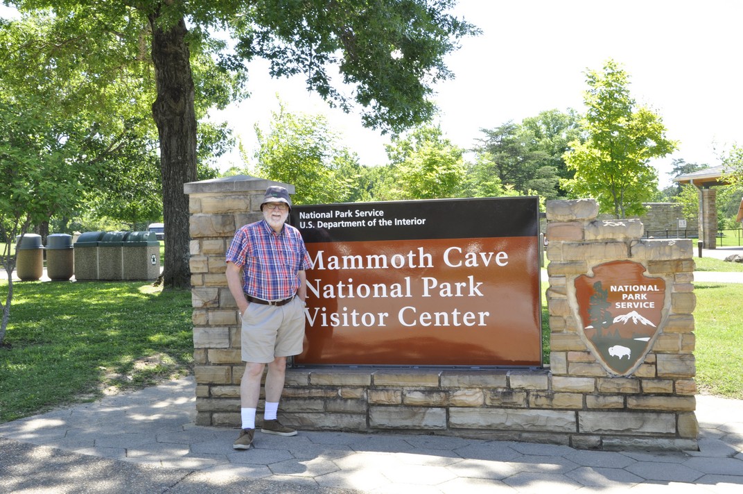
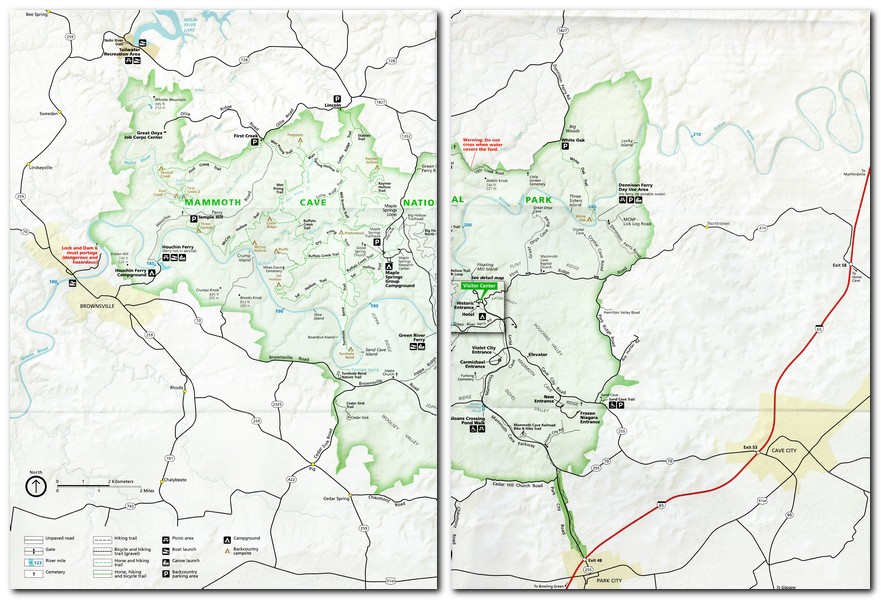


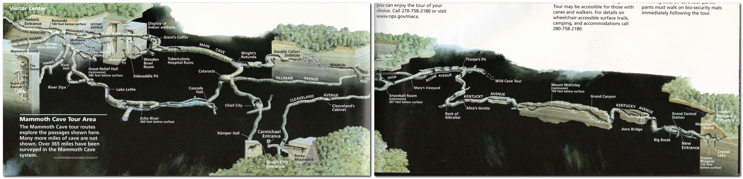
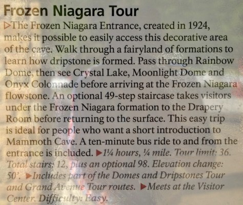


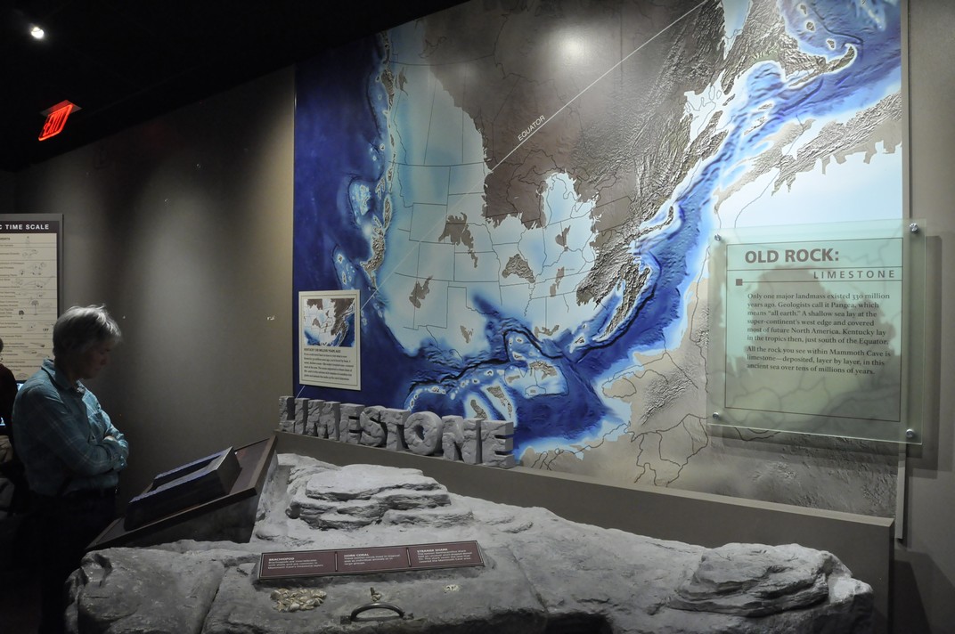

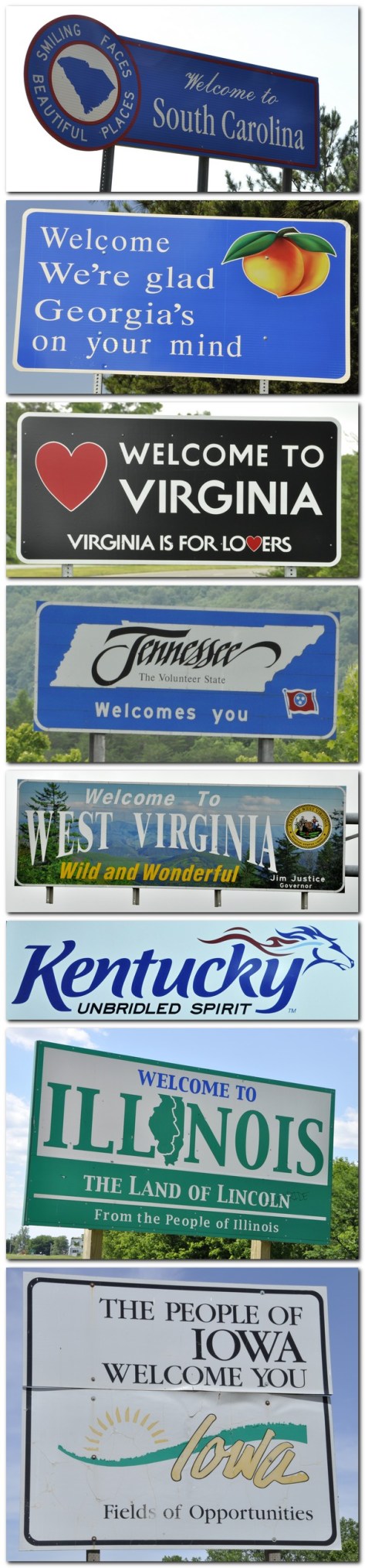


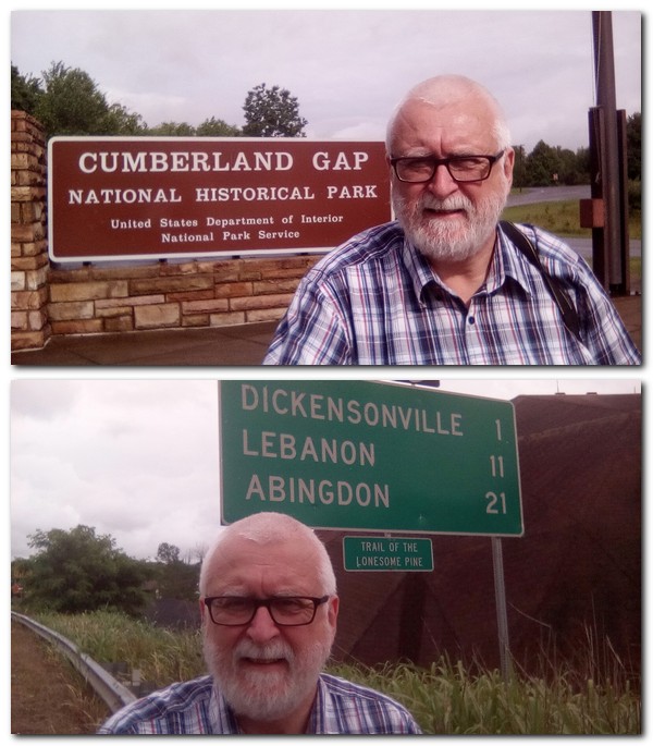
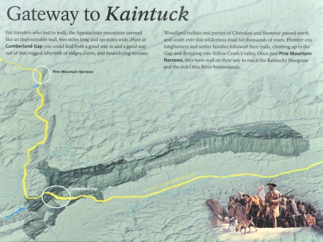
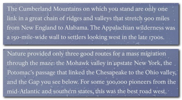
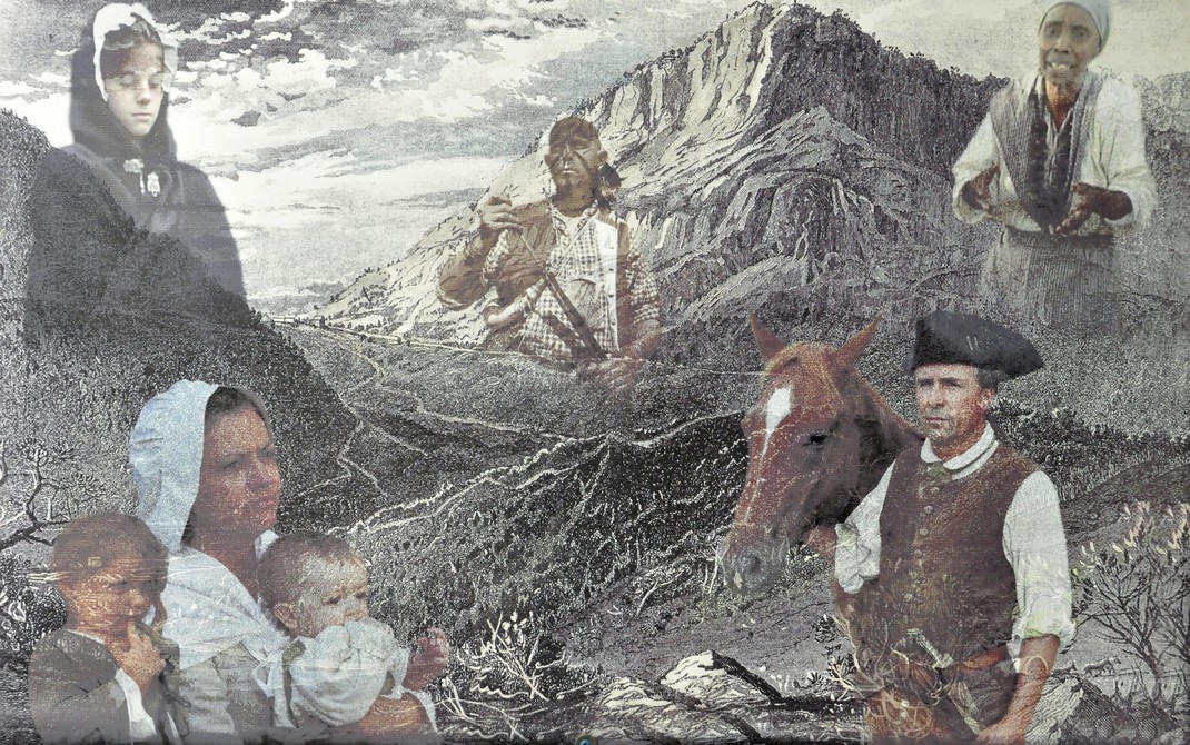
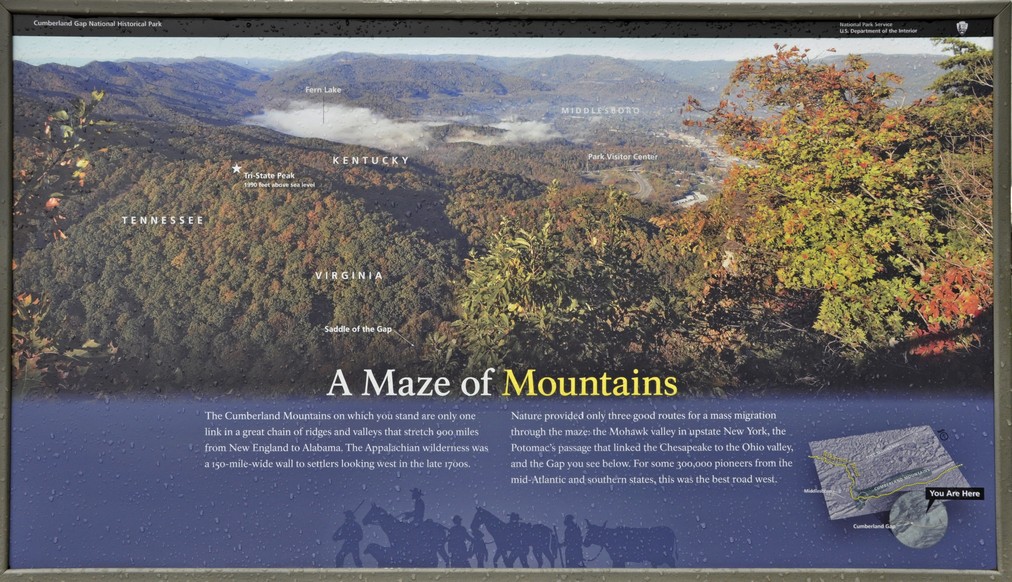


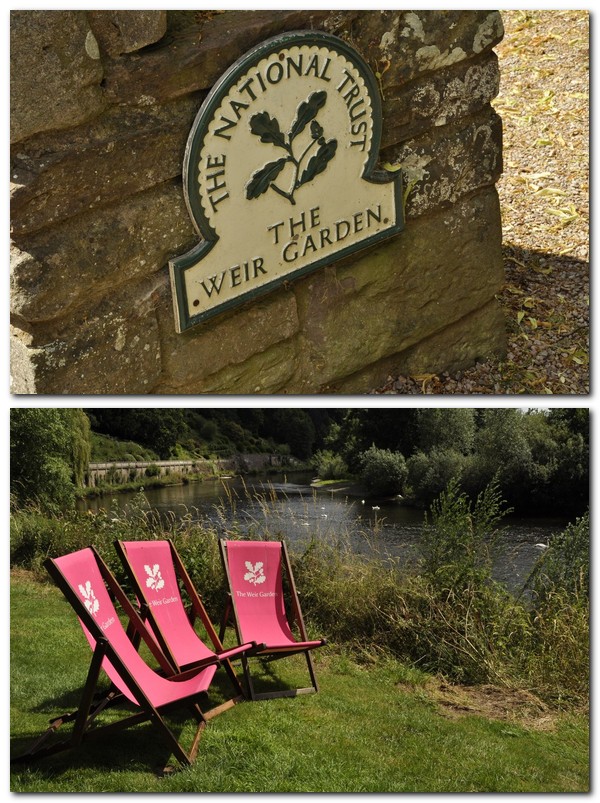
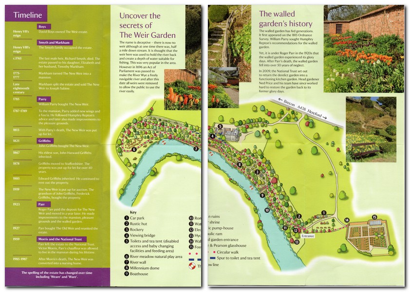


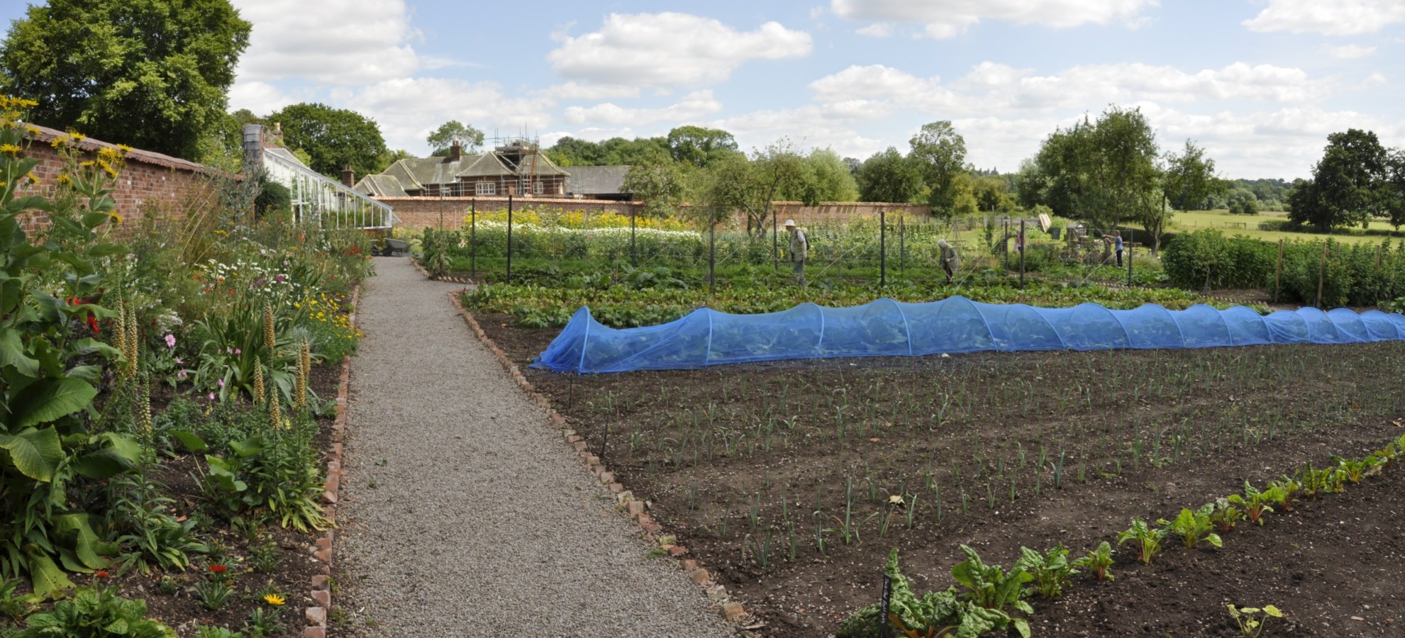
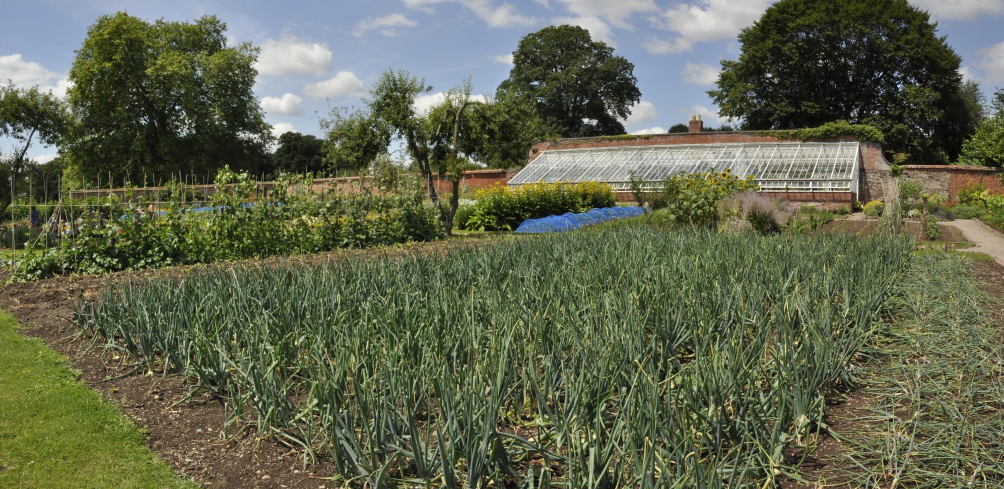


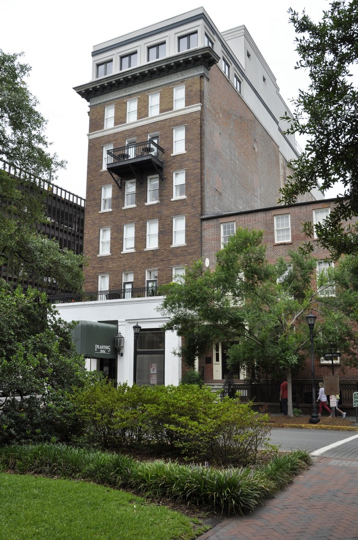


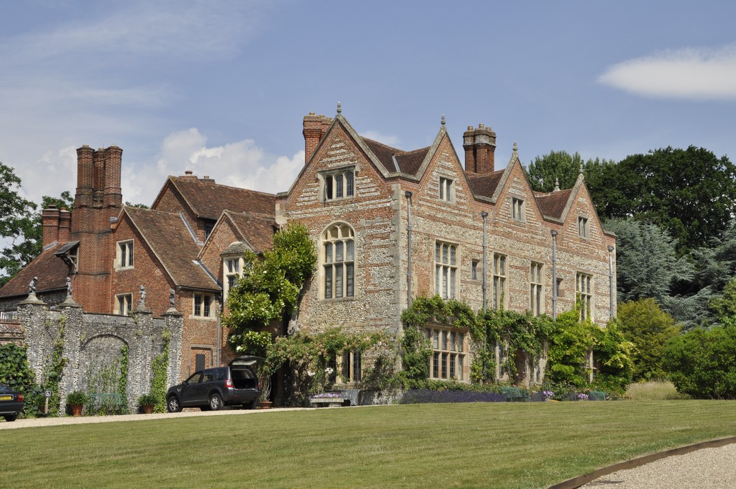


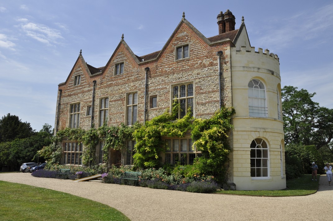


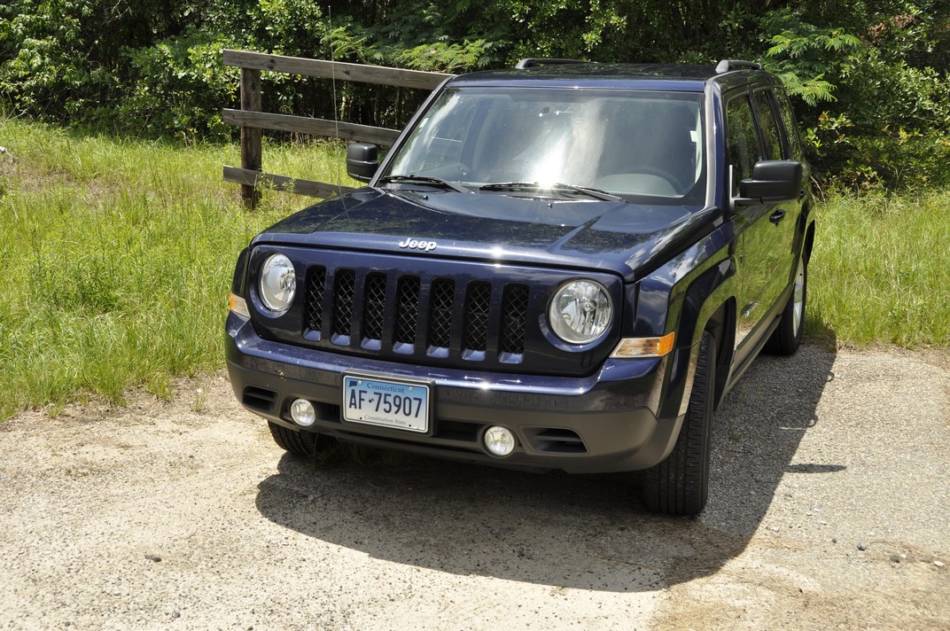
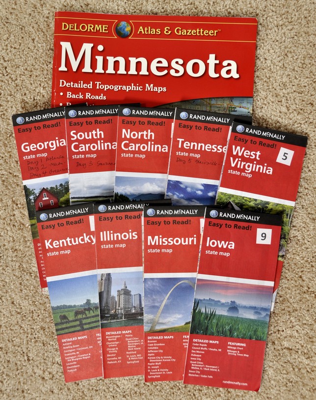
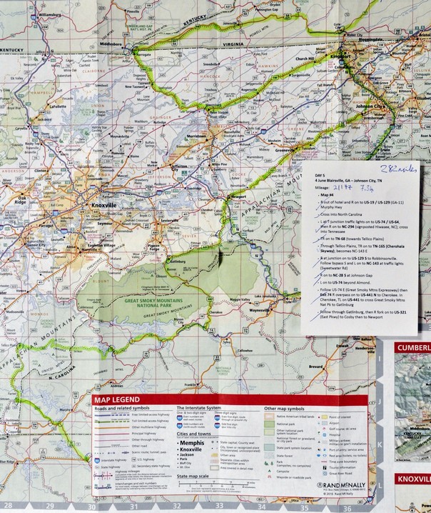


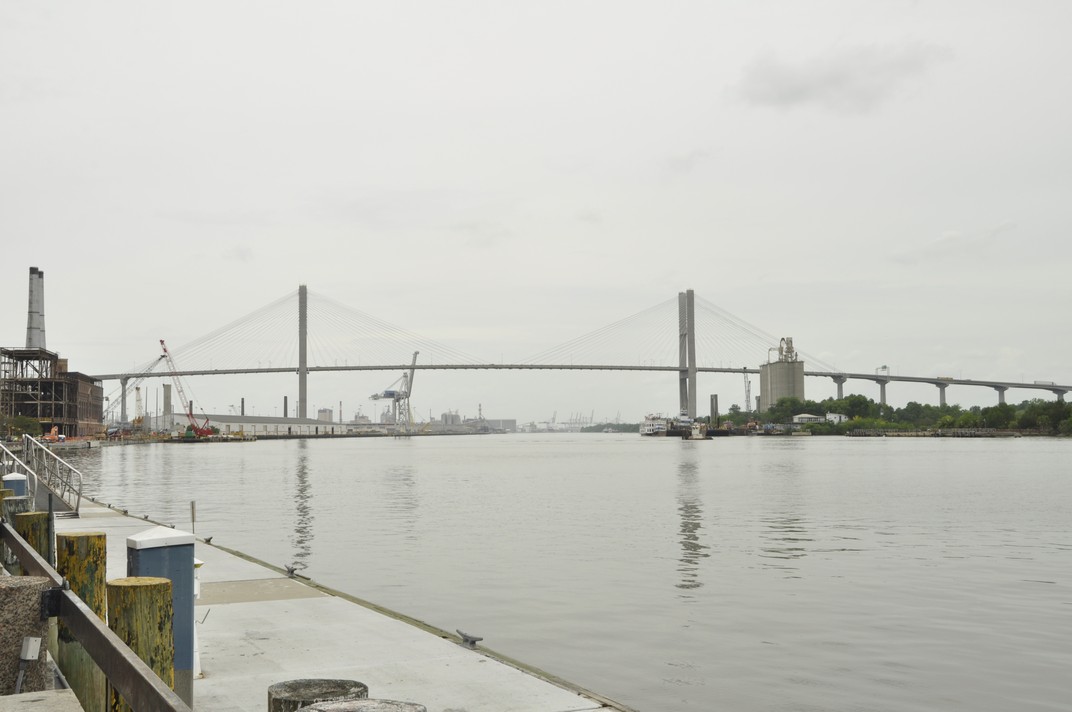
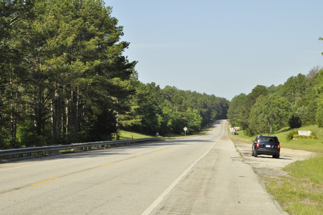
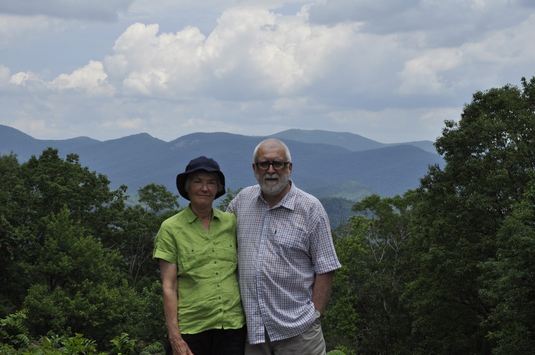
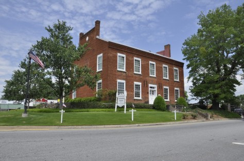
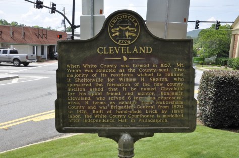
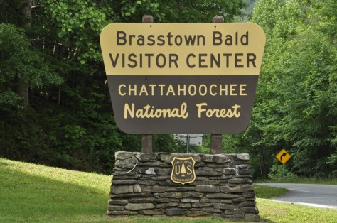

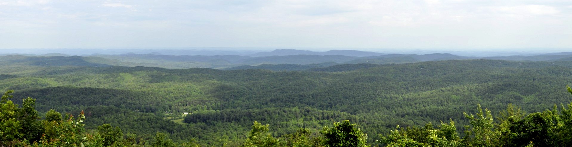
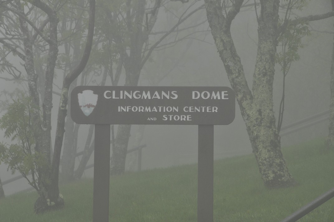
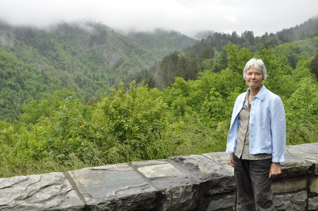
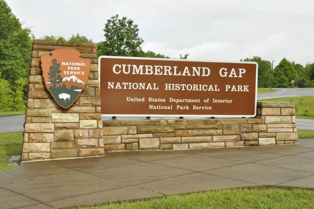
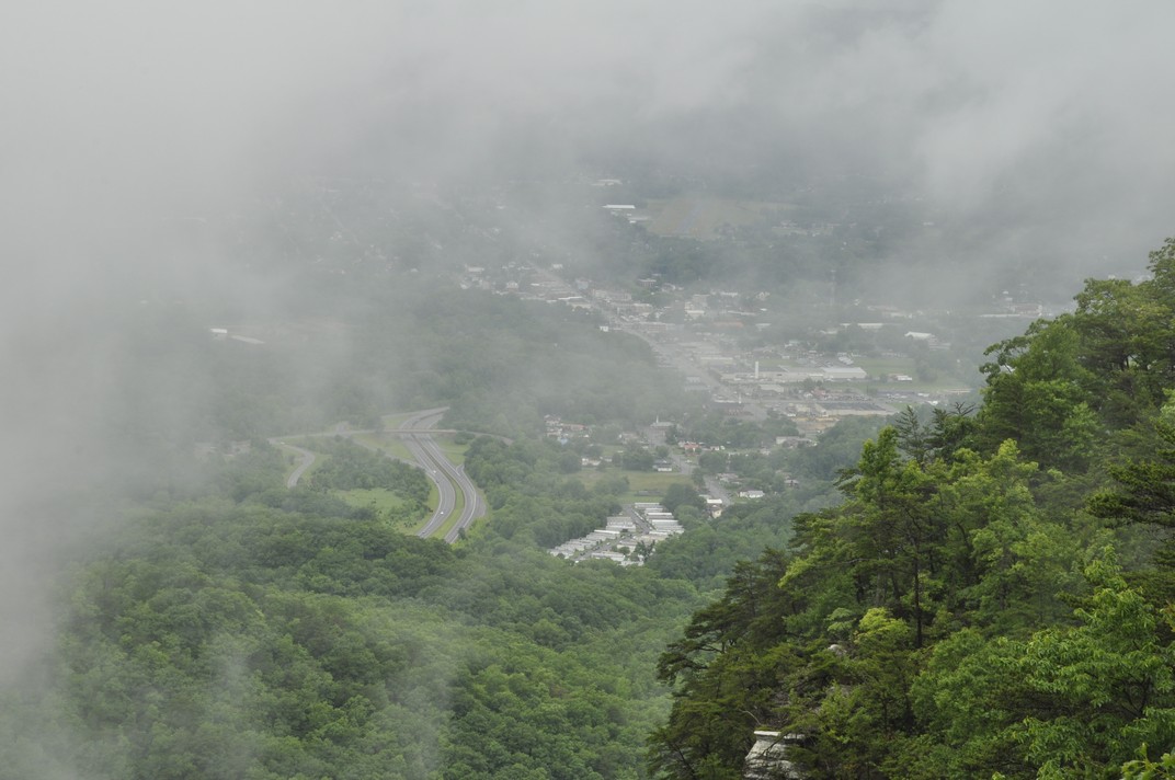
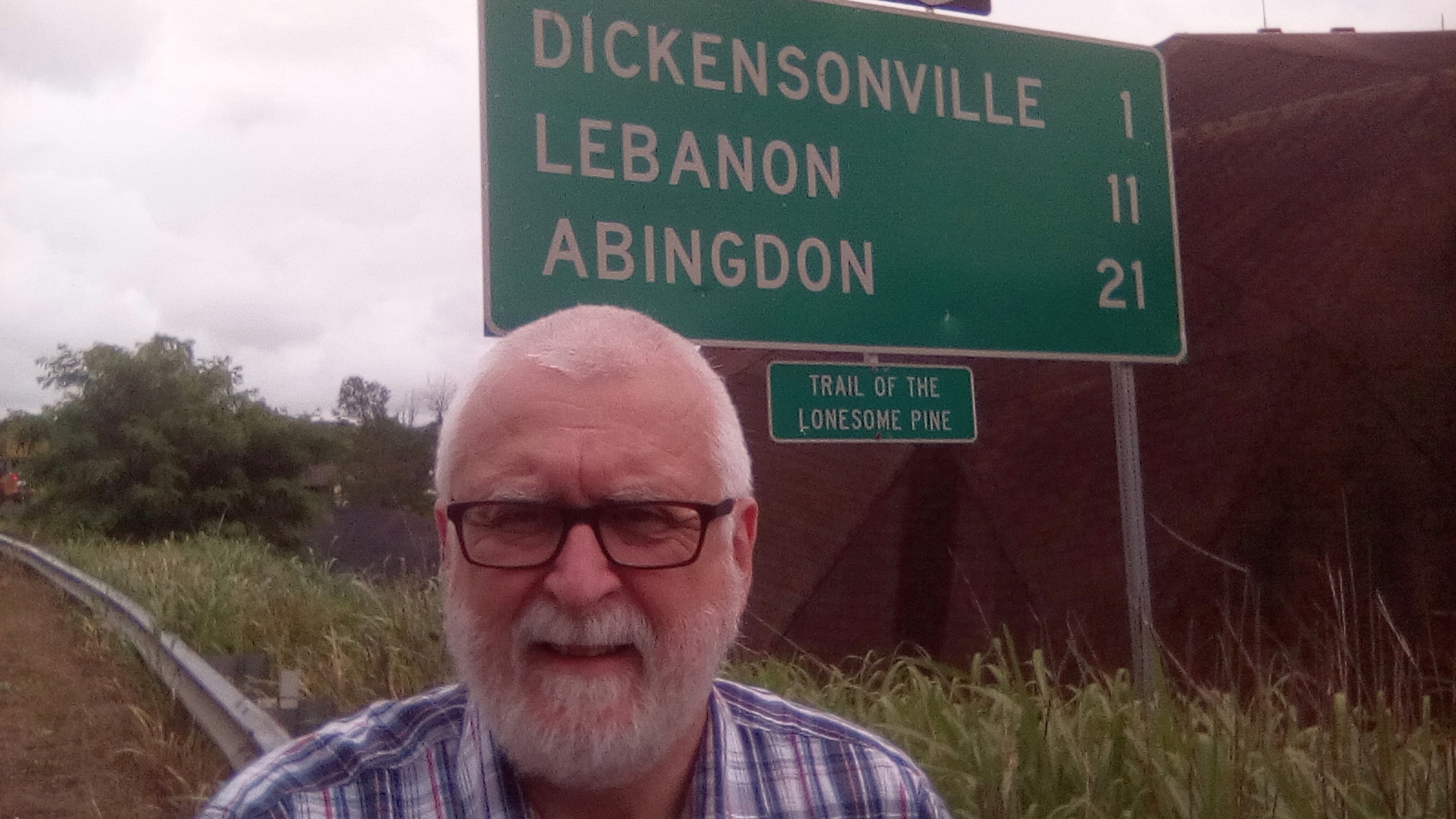
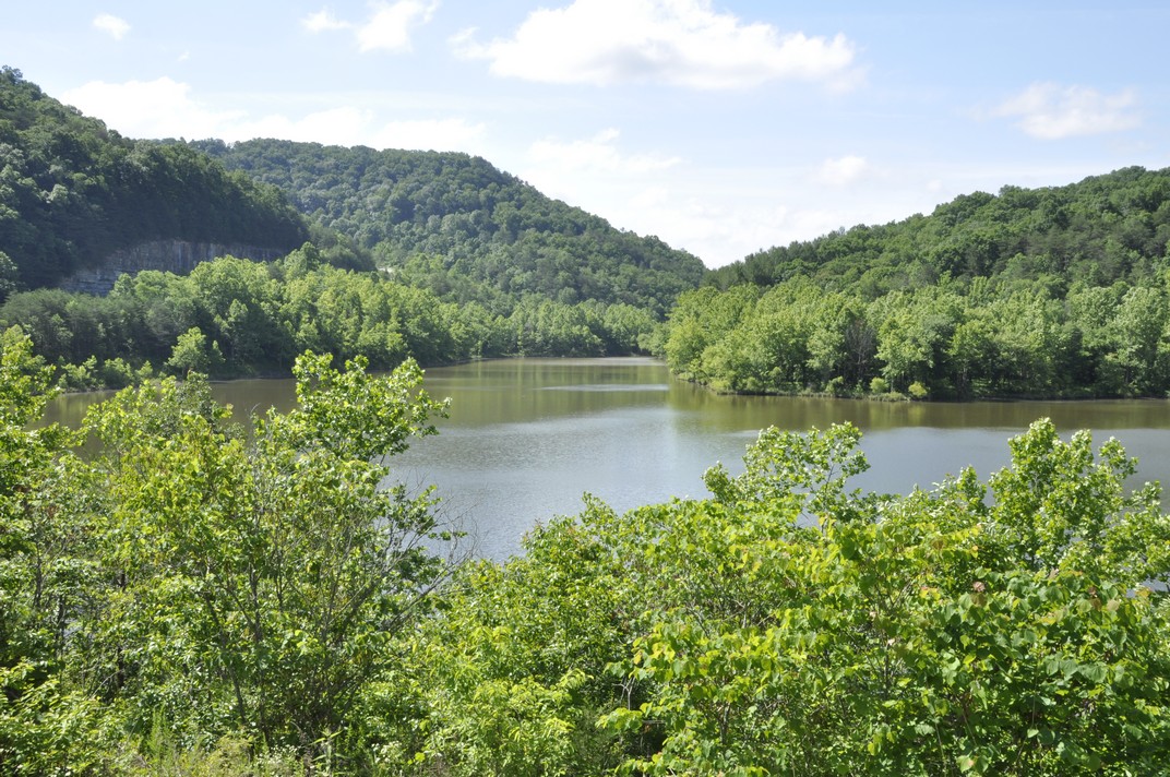
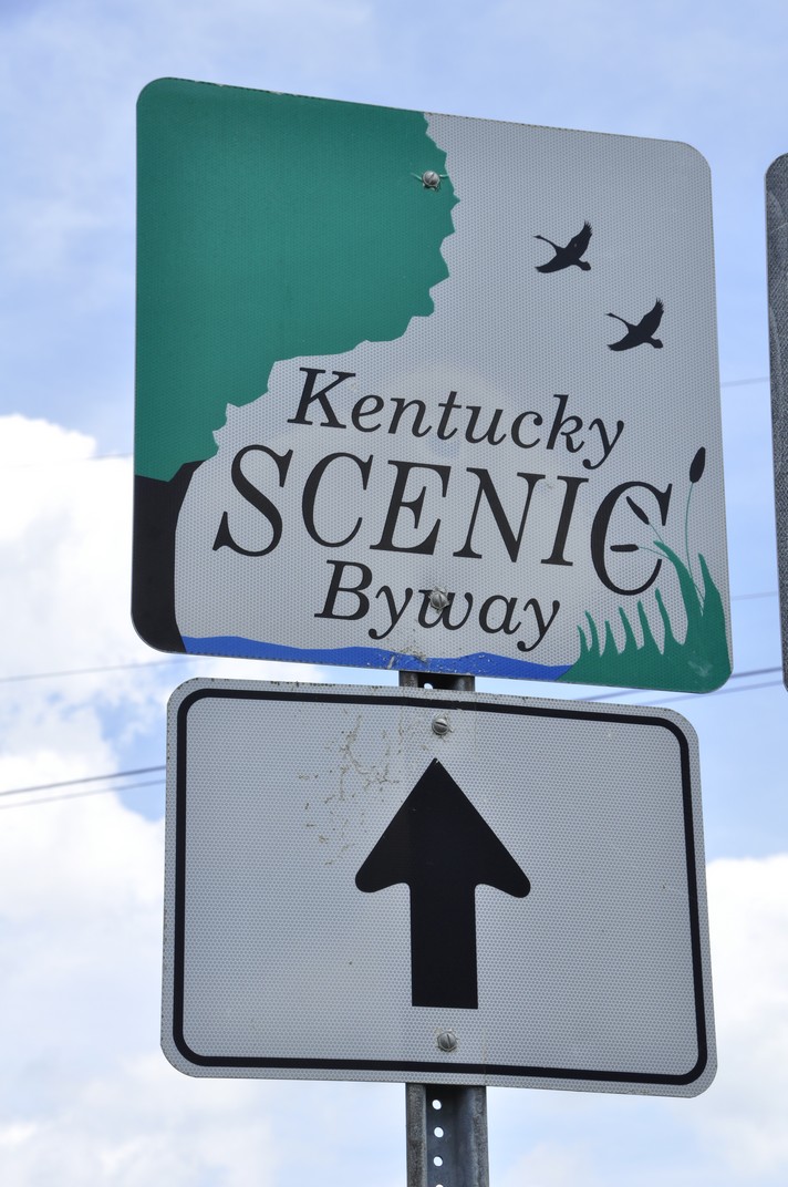


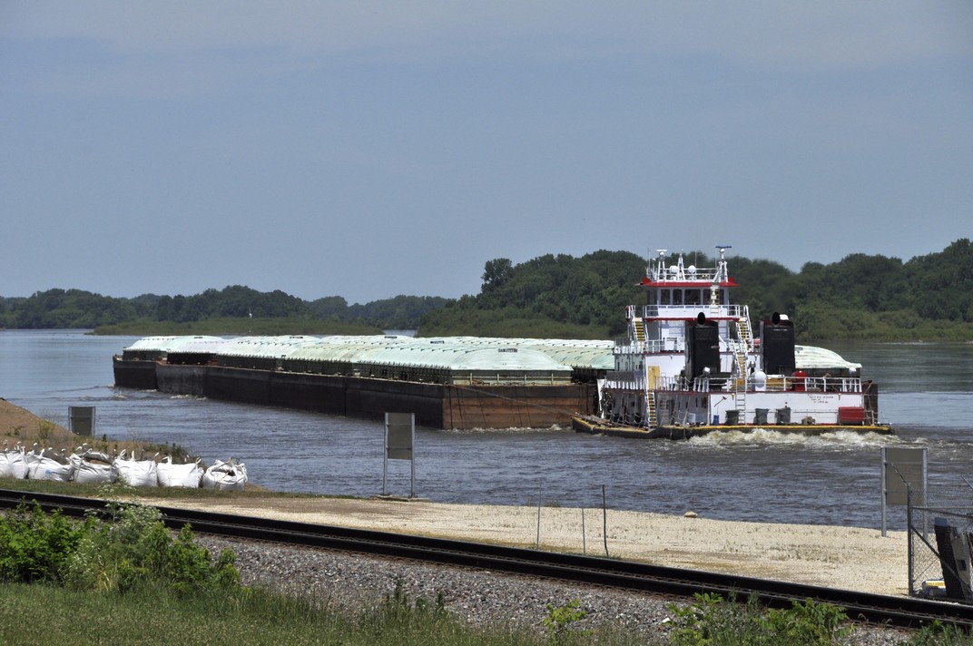
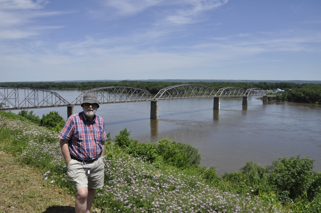
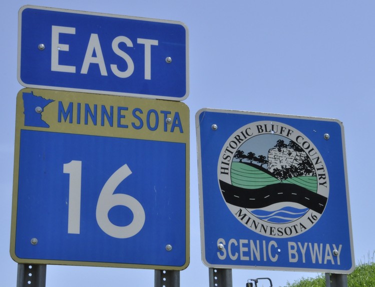

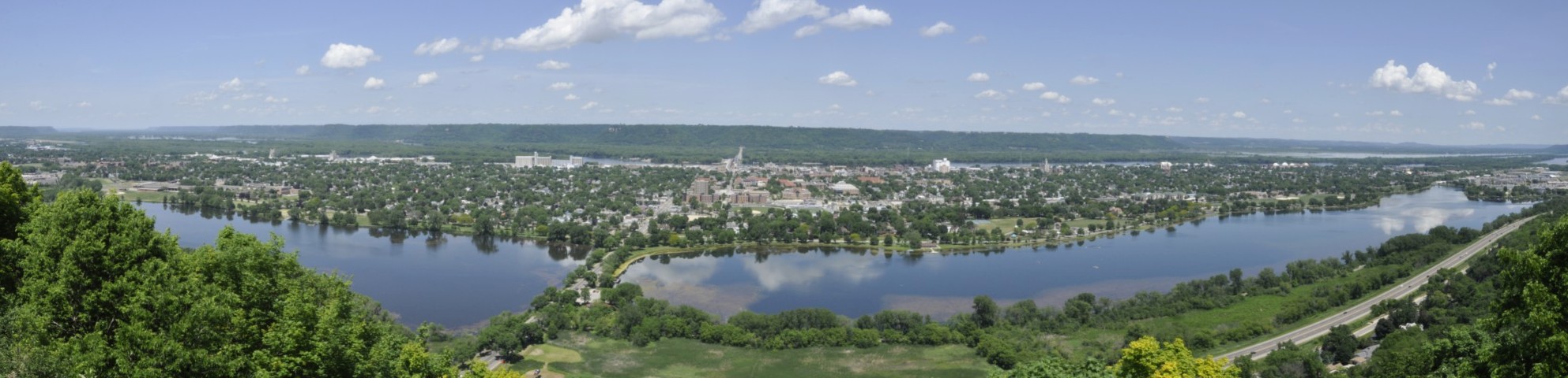
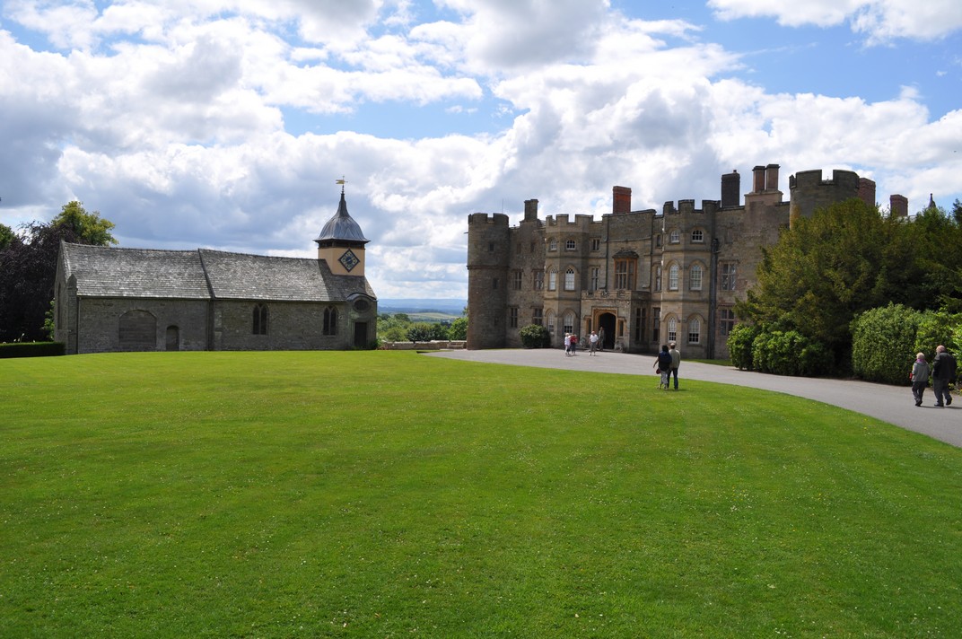


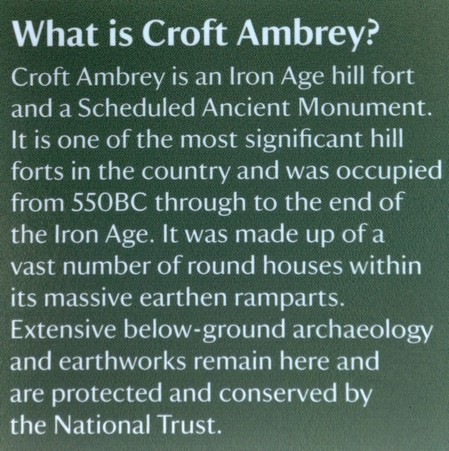
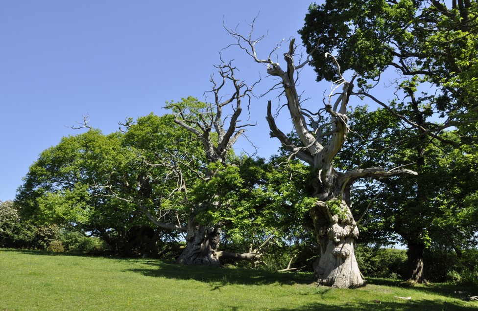


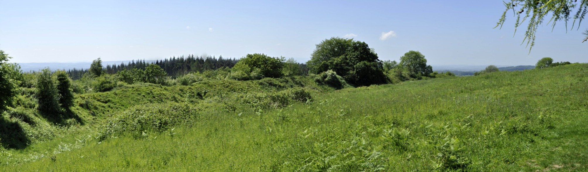


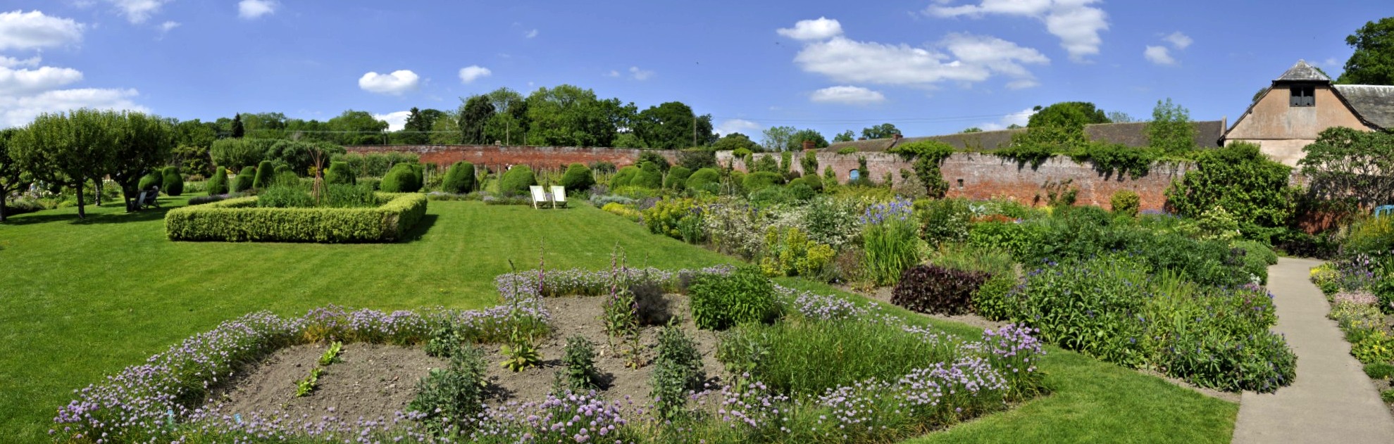


.jpg")


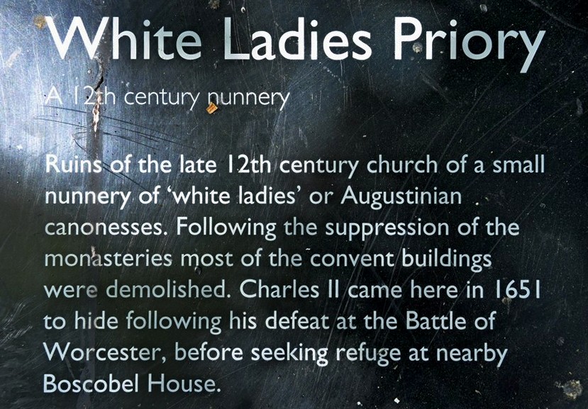


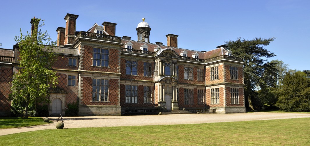
 But, as we reached the end of the footpath, we encountered the important ‘Sudbury’ fact. Occupied by the same