Do bridges speak to your soul? They do to mine. I find them completely fascinating. Many are architecturally stunning, and wonders of engineering, apart from the odd miscalculation that can lead to catastrophic collapse, as was the case of the Tacoma Narrows Bridge, Washington in 1940.
Many have stood the test of time, crossing obstacles in the landscape and connecting communities for hundreds of years.
Numerous bridges across rivers in the USA aided the westward expansion, and I wrote about many that we have seen (and crossed) in a blog posted in April 2022 (just scroll down to the section about the USA).
Some bridges, like the Golden Gate (opened 1937) in San Francisco, the Sydney Harbour Bridge (1932), or the Forth Bridge (1890) for example, have become icons in their own right.
Golden Gate (taken in 1979)
Sydney Harbour Bridge (in 2003)
Forth Bridge (in 2009)
More recent icons include the Millau Viaduct (20004) in France, or the road and rail Øresund Bridge (2000) connecting Denmark and Sweden (and featured in that excellent Scandi Noir series, The Bridge).
I’m now living in Newcastle upon Tyne, where there are several road, rail, and pedestrian bridges over the River Tyne. The iconic Tyne Bridge (1928) is home, during the nesting season, to some 700 pairs of kittiwakes, the furthest inland colony in the world.
The Millennium Bridge in Newcastle
The Tyne Bridge, Newcastle
Kittiwakes nesting on the Tyne Bridge
Kittiwakes on the nearby Baltic Centre for Contemporary Art
In the small community of Ironbridge, in Shropshire, stands a remarkable bridge over the River Severn. Erected in 1779, it was the world’s first cast iron bridge, the pieces fitting together as though constructed from wood.
While we were on holiday just over a week ago in North Wales we crossed the Menai Strait to Anglesey several times, on the Britannia Bridge that was first opened (as a tubular bridge of wrought iron to carry rail traffic only) in 1850. It was designed by Robert Stephenson, son of the great railway engineer, George Stephenson (the Father of the Railways), who was born in the small village of Wylam, Northumberland, west of Newcastle in 1781.
The Britannia Bridge today, seen from Plas Newydd, home to the Marquesses of Anglesey.
Thomas Telford
So why was the Britannia Bridge rail only to begin with? That’s because there was already a suspension road bridge, carrying the A5 trunk road, further east, designed and built by an even more famous engineer, Thomas Telford (1757-1834).
Telford was a Scottish civil engineer, who established himself as an engineer of road and canal projects in Shropshire, and designing numerous infrastructure projects in his native Scotland, as well as harbours and tunnels.
The Menai Suspension Bridge (and its ‘little brother’, the Conwy Suspension Bridge further east up the coast) was opened in 1826, as was the Conwy bridge.
It really is a marvel of early 19th century engineering, being the world’s first iron suspension bridge, 1,265 feet/305m long, with a central span of 579 feet/177m and its roadway set 98m/30m above the water to allow tall ships to sail beneath.
It was constructed from iron links, and you can appreciate its construction in the video below as we crossed the bridge. It is remarkable that it’s still open to traffic after almost 200 years, although it is currently undergoing some serious maintenance to extend its life.
Exactly the same construction method was used on the Conwy Bridge. Check out this informative National Trust video.
The three Conwy bridges from Conwy Castle.
Conwy Suspension Bridge
Entrance to the railway bridge seen from the walls of Conwy Castle
The Conwy bridgeis open only to pedestrians, and is managed by the National Trust. To the west is a modern road bridge. To the east, a tubular rail bridge, also designed by Robert Stephenson, and opened in 1849.
Until 1972, the Menai Suspension Bridge was the only road link on to Anglesey.
After a major fire in 1970 caused extensive damage to the Britannia Bridge, it was reconstructed and a second deck was added above the rail level to take road traffic. That was opened in 1980. Even so, and although much wider than the Menai Suspension Bridge, it carries traffic in each direction in one lane only, reducing from dual carriageway on both sides of the bridge. And is therefore a source of considerable traffic congestion at busy times of the day.
On our way back home from North Wales, we stopped off briefly at Speke Hall on the eastern outskirts of Liverpool, right next to Liverpool John Lennon Airport. Our route in from North Wales took us over the Mersey Gateway Bridge. Opened in 2017, and spanning the River Mersey and the Manchester Ship Canal, it adds a new elegance to the local landscape.
A couple of nights ago, on 30 August, we observed an uncommon natural phenomenon. A ‘Super Blue Moon’.
To be honest, neither ‘Super Moon’ or ‘Blue Moon’ had registered with me until then (and I’m approaching my 75th birthday). I’ve never been particularly interested in all things celestial or cosmic. But as the phenomenon had been mentioned on the lunchtime weather forecast, I decided to take a look outside around 9pm to see what all the fuss was about.
And I wasn’t disappointed. There, climbing the horizon to the southeast of my home on the northeast outskirts of Newcastle upon Tyne (in NE27 to be precise), was this large, golden orange orb, a ‘Super Blue Moon'(rise).
Moonrise over NE27 at 21:05 on 30 August 2023.
I had to do some background reading. And there’s plenty out there. Because the Moon’s orbit is elliptical, there are times when it is closest to the Earth (at its perigee), and when it’s furthest away, and therefore appears smaller in the sky (at its apogee).
And when a full moon coincides with its perigee, we see a ‘Super Moon’, appearing much brighter and larger in the sky. Although not an ‘official’ astronomical term, ‘Super Moon’ is used to describe a full moon that comes within at least 90 percent of perigee.
Just four days before my 68th birthday in 2016, the Moon was closest to the Earth since January 1948 (I was born in November that year). It must have been a cloudy night because I have no recollection of having observed it. We were very lucky on the 30th; not a cloud in the sky.
And it was also a ‘Blue Moon’, the second full moon in a calendar month. Since the lunar cycle is 28 days, ‘Blue Moons’ are not particularly common: Months with 31 days—January, March, May, July, August, October, and December—have a much better chance of hosting a blue moon because of their length. On average, a blue moon occurs once every 33 months or full moons, 41 times per century, or about seven times every 19 years.
And the ‘Super Blue Moon’ we observed is a rather rare event: about 25% of all full moons are supermoons, but only about 3% of full moons are blue moons, NASA says. The time in between super blue moons is rather irregular, with 10 years the average and 20 years the maximum.
So I was pleased I made the effort to look at last Wednesday’s ‘Super Blue Moon’. We won’t see another until January 2037, when I’ll be approaching (hopefully) my 89th birthday. Now there’s a target to aim for!
As you exit the Tyne Tunnel south on the A19, there’s a road sign on the right, pointing left towards South Shields, Jarrow, and Hebburn on the A185, and a brown sign for Jarrow Hall and St Paul’s, with the English Heritage logo (right) prominently displayed. A road we’d not been down until last week.
St Paul’s is a part-Saxon church and ruins of a Saxon-medieval monastery, dating from the 7th century, which surely must be one of the most significant sites for early English Christianity. It has been an active site of worship for over 1300 years.
The site was excavated by the late Professor Dame Rosemary Cramp of Durham University (who died in April this year) between 1963 and 1978. Today, flat stones mark out the Anglo-Saxon monastery, and cobbles the later medieval buildings.
The church and monastery were built on land given by King Ecgfrith of Northumbria in AD 681, beside the River Don, on the south bank of the River Tyne, into which it flows (map). The community was founded by Benedict Biscop (right) an Anglo-Saxon abbot from a noble Northumbrian family, who had also founded—seven years earlier—St Paul’s twin, St Peter’s (below) on the north bank of the River Wear at Monkwearmouth (map).
Steph and I had first come across the name of Benedict Biscop when we visited the National Glass Centre in Sunderland in November 2022. In AD 674 Biscop had sought help from craftsmen from Gaul to make windows for St Peter’s, which is close by the glass center.
So why is St Paul’s so significant? Having entered the monastic life, aged seven, at Monkwearmouth around AD 680, and transferring later to St Paul’s at Jarrow, their most famous resident was Saint Bede (often known as the Venerable Bede). Although traveling to other ecclesiastical communities around the country, Bede essentially spent his life at Jarrow, and died there around AD 735. He is now buried in Durham Cathedral.
Portrait of Bede writing, from a 12th-century copy of his Life of St Cuthbert (British Library, Yates Thompson MS 26, f. 2r).
Bede is considered one of the most important teachers and writers of the early medieval period, his most famous work being Ecclesiastical History of the English People written about AD 731. In 1899, Pope Leo XIII declared him a Doctor of the Church, a rare accolade indeed.
So what is there to see at Jarrow¹? St Paul’s was dedicated on 23 April 685, but the only surviving Saxon section is the chancel.
The Victorian north door, with west door (and main entrance today) on the right.
The rest was added or refurbished by the Victorian architect Sir George Gilbert Scott in the 1860s. In the nave of the church the foundations of the original church can also be seen in a window placed in the floor.
The Anglo-Saxon chancel on the right. A belfry was added in the 12th century.
Click on the image below to open a larger version.
The dedication stones can be seen above the arch leading into the chancel which is the only surviving section of the original Saxon church.
The ruins alongside the church are quite extensive and date mostly from the 11th century. And, like all other ecclesiastical communities it suffered during the Dissolution of the Monasteries during the reign of Henry VIII. Here is a selection of some of the photos I took during our visit. I have put all of them (including images of the English Heritage information boards) in this photo album.
Northumbria was certainly a cradle of Christianity in England. To the south of St Paul’s and St Peter’s stand Finchale Priory and Durham Cathedral on the banks of the River Wear. North and northeast in the heart of the Northumberland landscape stand at least two medieval chapels at Edlingham (dedicated to St John the Baptist) and Heavenfield (dedicated to St Oswald), and the early Christian pilgrimage site of Lady’s Well, Holystone.
St Jon’s Anglo-Saxon church, Edlingham
¹ I must take this opportunity to recognise the very friendly and knowledgeable volunteers inside St Paul’s who made us feel most welcome.
Moving back to the UK from South America in March 1981, we began the search for a house not too far outside Birmingham (where I started a lectureship in plant biology at the university). Quite quickly we identified a three bedroom house, built in 1975, in the market town of Bromsgrove in north Worcestershire, 13 miles south of the university campus, moving in at the beginning of July.
While the previous owners had made a start to creating a garden, little had been accomplished, apart from planting a weeping willow tree and some spiny berberis bushes, and constructing a lean-to glasshouse from old window frames at the bottom of the garden.
Over the next 39 years Steph worked hard to make a beautiful garden, albeit with a break of 19 years between 1991 and 2010 when we lived in the Philippines and only had the opportunity to work on the garden during our home leave each year, six to eight weeks in the summer months. Click on the image below to open a higher resolution version.
Very early on we removed the weeping willow, and replaced it with a Himalayan birch (which, by 2017, had become too tall so we had it felled), added a fishpond, and a rockery, as well as expanding the flower beds all round. A free-standing glasshouse replaced the lean-to, and where that had once stood, Steph developed a small vegetable plot, mixed with ornamentals, foxgloves being a common self-seeded addition.
The rest of the garden (at the rear of the house) was a lawn whose care (if you can call it that) was in my hands, mowing the grass every couple of weeks or so. While we’d been in the Philippines we had a gardener come once a month, from Spring to early Autumn, to mow the grass both front and rear of the house.
On the front there was a small lawn and a couple of flower beds, one of them running the length of the drive. In Spring this would have a stunning display of golden daffodils, and yellow and red tulips. Neighbors always commented on how nice they looked as you entered Davenport Drive. And a vigorous Clematis montana over the kitchen window.
Steph liked to plant lots of flowering perennials and among our favorites were the promiscuous columbines, which freely hybridised and gave us a whole range of flower colors and sizes.
After we returned from the Philippines on my retirement in 2010, Steph really threw herself into rediscovering her garden. So it was with a tinge of sadness that we left that garden behind, on 30 September 2020, when we moved north to Newcastle upon Tyne. We weren’t sure what sort of property we would find to move into, nor the state of its garden.
In the event, we bought a new-build house (built in 2018), and moved in at the beginning of March 2021. Moving house at the height of the pandemic was both stressful and remarkable. And loaded on to the removal van were several crates of plants that Steph had propagated from seeds or cuttings from her old garden. So, as she planned her new garden, she had this legacy of Bromsgrove favorites to fall back on in some measure.
The garden at our new home was a blank canvas, just rectangles of grass front and back, no flower beds at all, except for a row of privet bushes on the front. How totally uninspiring, yet a serious challenge.
By April, Steph had finalised a design for the garden at the rear. We took out the privet on the front and dug flower beds along one side and under the bay window.
We’d quickly discovered that the soil was very heavy indeed, so we contracted the heavy digging to a local firm.
Even though we had a layer of top soil added all round, on reflection we should have added more organic matter and worked it in, as well as some sharp grit to increase drainage. The garden does flood close to the house when we get heavy or persistent rain. But that has added to the challenge of learning what plants we can and cannot grow successfully.
Steph was keen to get many of her plants in the ground, and by June 2021, the flower beds were beginning to take shape.
By August-September, things were beginning to look much better, and we’d had the first butterflies appear.
In February 2022 we planted a crab apple, var. Evereste, which did flower that season, and a year later was well and truly established and producing bright orange fruits.
Now in August 2023, many of the plants are well-established, and for several months the garden has given us great pleasure. Steph is certainly pleased with how the garden has developed, although there’s so much more to do. It’s a work in progress.
Another fine feature is the auricula theater that I made for Steph and in which we had a great display of these wonderful primulas earlier this year.
But one aspect that has given us perhaps the greatest pleasure has been the significant increase in biodiversity. Many of our neighbors are not keen gardeners, and have replaced what lawn they had with artificial grass. Nor have they planted flowers to attract pollinating insects.
In contrast, our garden is a hive of insect activity. I’ve seen at least six species of bees, and many other pollinators that I am unable to identify.
Butterflies (although not so frequent visitors to the garden) have included red admiral, peacock, little tortoiseshell, small white, and comma.
As for birds, we have a family of pied wagtails that regularly visits us throughout the year. But so far, the garden hasn’t attracted as many different species as I’d hoped for. We’re somewhat reluctant to put out bird feeders, worried that spilt food might attract rodents into the garden. But we have seen goldfinches, a mistle thrush on one occasion, and more recently, linnets a couple of times. These photos are courtesy of Northamptonshire photographer Barry Boswell.
Pied wagtail
Goldfinch
Mistle thrush
Linnet
Starling
Woodpigeon
House martin
Herring gull
Magpie
In summer the sky is full of house martins that nest on neighbors’ houses, but sadly I’ve only seen one swift this year. Starlings are common and often land in a small flock on the lawn, as do the occasional wood pigeons. Herring gulls and magpies call to us from surrounding roofs.
Anyway, as I mentioned, the garden is a work in progress, and although I actually do very little in the garden (gardening is not my thing) I really appreciate all the effort that Steph has taken to create a thing of beauty.
It really is! Standing at the heart of Crook Hall Gardens along the bank of the River Wear in Durham, it’s hard to believe you are only a short distance from the center of a bustling city. Peaceful hardly describes it. Just the occasional rumble as trains arrive at or depart from Durham railway station just to the north.
The River Wear alongside Crook Hall Gardens.
Since we returned from our trip to Minnesota towards the end of June, there have been few opportunities, weather-wise, for any excursions. I can’t remember when we last experienced such a dismal July (after all the hot dry weather of June); it’s been so cold and wet.
Anyway, the forecast for yesterday seemed hopeful, so we decided to make the short, 22 mile and 30 minute drive south to Durham to take in Crook Hall Gardens. The Trust acquired the property in 2022, and if I understood correctly, it was opened to the public for the first time in March this year.
Crook Hall has its own car park, free for National Trust members, that really is a blessing in a city where parking is at a premium, and not cheap. We arrived around 10:20, and headed immediately to the cafe for a refreshing Café Americano.
The gardens have been there for many centuries. In fact there is a 14th century medieval hall (which is open to the public) adjoining an 18th century Georgian house overlooking a beautiful walled garden.
Crook Hall was a family home since the 1300s, and occupied over the centuries by several families who stamped their mark on the property. Originally it was the home of the Billingham family for 300 years from 1372. Between 1834 and 1858 it was rented by the Raine family. Canon James Raine (right, 1791-1858) was a historian and librarian at nearby Durham Cathedral. He died at Crook Hall.
By 1979 the property was essentially derelict, but was taken on by Mary and John Hawgood who rescued it from oblivion. Mary believes she saw The White Lady of Crook Hall in 1989. The Hawgoods moved on in 1995 when it was sold to Maggie and Keith Bell, and Crook Hall became a wedding venue, with the gardens open to the public on occasion.
With the onset of the Covid-19 pandemic, the Bell’s wedding business collapsed, and in 2020 Crook Hall was put up for sale. Then, in stepped the National Trust – thankfully.
Here’s a potted history of Crook Hall from a 2020 article in The Northern Echo.
The gardens, which cover about 10 acres (or 4 ha), comprise a series of interconnected gardens, each with their own character, are a credit to the National Trust garden staff and volunteers.
Being mid-summer, many of the flower beds were in full bloom, although roses and some others were past their best. Notwithstanding, the gardens were a delight for the spirit, and by the looks on the faces of other visitors (it was quite busy considering) they also felt the same way.
A path leads up the garden from the entrance and cafe, and immediately on the right is a cotoneaster maze planted in 2000. We gave that a miss, heading instead for the Solar Wing Garden and the Walled Garden.
Entrance to the maze
Just a hint . . .
The footpath leading up into the garden.
Wild flower beds alongside the path
Looking back towards the entrance and cafe.
I really do like the style of planting adopted at Crook Hall, with so many different species clustered together to provide a kaleidoscope of color.
Entrance to the Solar Wing garden
Who’s smiling at who?
Adjacent to the medieval hall is a second-hand bookshop in the Georgian house, and on one wall, some of the brightest—and botanical—wallpaper I have ever seen.
Passing through a small courtyard (with a small fountain and yet another statue) we headed towards the Moat Pond at the top of the garden. The pond itself is a relatively new feature, created in 1998 beside what was a 14th century defensive dry ditch.
Turning back towards the entrance, there is a series of four gardens: the Silver and White Garden (dating from 1983); the Orchard; the Shakespeare Garden (with Will observing the garden from a corner); and finally the Cathedral Garden, with its magnificent views towards the city and Durham Castle and Cathedral. There’s also a Wooded Glade.
In the Wooded Glade
As you exit the Cathedral Garden and turn towards the maze, a side path leads to a pebble garden. Also there are informal beds of wild flowers.
Ever since we noted, in the National Trust Handbook for 2023, that there was a new property in Durham, we’ve been waiting for an appropriate day to visit. Although the weather had been forecast as showery, we only experienced (for just a short while) threatening black clouds overhead, but apart from that, a bright and sunny—and for once, warm—day. We shall return.
Wallington Hall overlooks the Northumberland countryside near Cambo (map). It was remodelled in the Palladian style between 1738 and 1746 from an earlier William and Mary house (built around 1688) for Sir Walter Calverley Blackett (right, 1707-1777) by the architect Daniel Garrett. It is believed that renowned landscape architect Lancelot ‘Capability’ Brown (1715-1783, who was born in nearby Kirkharle and went to school in Cambo) advised Sir Walter on the location of the walled garden (3 on the map below), and perhaps even designed the Owl House (2) there.
After Sir Walter’s death in 1777, Wallington was bequeathed to his sister Julia’s family, the Trevelyans, and it remained in the family until 1942, when it was gifted to the National Trust.
Since returning from the USA in mid-June, the weather in the UK has been decidedly unsettled. So we have grabbed every good weather opportunity to get out and about. Unfortunately, due to my reduced mobility these days, I’m unable to walk the distances that we have enjoyed in the past. But provided my pain medication kicks in appropriately, then I can manage a relatively short walk. Around a mile or so is possible.
With that in mind, we headed to Wallington with the aim of enjoying the walled garden in mid-summer. And to compare the garden today with what it was like a decade ago.
My first impression was that the walled garden today is much brighter, so to speak, with a new fiery border along the terrace in front of the Edwardian conservatory and below the Owl House.
Here are some of the plants in that bed. What a magnificent sight to welcome visitors to the garden.
Until quite recently, the conservatory was open to visitors, indeed as recently as our visit there in mid-December 2021, but it is now closed while plans are drawn up for its refurbishment. Which isn’t going to come cheap. Perhaps it was damaged in one of the winter storms that affected the estate.
Ten years on, the garden has developed a lot, and is a credit to the hard work of the staff gardeners and volunteers. Here are two images, taken from more or less the same spot, ten years apart, looking from the water terrace at the top of the garden eastwards down the garden. In the 2013 image, the conservatory and Owl House can be clearly seen.
At least one new ‘garden room’ has been created, surrounded (like the others) by trimmed cedar hedges.
And more, it seemed to me, has been made of the small pond area at the bottom of the garden.
On the south side of the garden, another large set of beds has evolved over the decade. Here are images from 2013 and last week.
The colors are more muted this year, with the fiery varieties moved to the conservatory terrace. Here is some of the 2023 planting.
One of the gardeners explained that it’s a never-ending task to plant and replant all these beds. He mentioned that in the autumn they plant several thousand bulbs, so I think a visit next spring is on the cards to see the early color.
The terrace fountain area at the top of the garden, near the entrance, was ‘dry’ on our latest visit (bottom image below). Normally the small pond is full, and water runs through a rill across the terrace.
I believe this part of the garden is fed from a large lily pond outside the walls. It looked as though there had been work on the earth dam at the eastern end, and the water level was low. Hence the dry fountain inside the garden.
The walled garden is a 15 minute or so walk from the house through the East Wood. Alongside the lake (above) there’s a new addition: a carved owl, from the tree trunk of one of the trees brought down during Storm Arwen in November 2021. There’s apparently another carving, but we didn’t manage to find it. Both are by tree sculptor Tommy Craggs from County Durham.
There are lots of owls at Wallington. Not only on the roof apex of the Owl House (seen in several of the images above), but also adorning the gate posts of the courtyard at the rear of the house.
The owl features in the Calverley family crest, Calverley (a West Yorkshire name) being the former surname of Sir Walter Blackett mentioned at the beginning of this post.
After being cooped up inside for a couple of weeks because of the unseasonably wet and cool weather, it really was a pleasure to return to Wallington. Just 23 miles and around 40 minutes from home, Wallington is sure to be on our National Trust itinerary year after year, season after season.
. . . I no longer hold any religious beliefs. I shed those almost six decades ago.
But Steph and I do enjoy exploring many of the fine—awesome even—churches, abbeys, and priories that were constructed centuries ago by Christian communities to reflect ‘the glory of their omnipotent God’.
On the map below I have marked those we have visited over the years. Each icon is accompanied by several photos, and links to websites, my own blog posts and/or photo albums, where you will find much more information.
Ruins have a blue marker; churches that are still open have a purple one. Cathedrals are marked dark red for those we’ve actually been inside, whereas those viewed from a distance are marked yellow. One 16th century religious curiosity, Rushton Triangular Lodge, has a black icon.
There are also three pagan sites on the map that pre-date Christianity by centuries if not millennia, shown with green icons.
Most of the monasteries and priories were founded by the Cistercians, the Benedictines, and Augustinians among others in the immediate centuries following the Norman invasion of England in 1066.
During the Dissolution of the Monasteries enacted by Henry VIII between 1536 and 1541 many of these communities were disbanded and their assets claimed by the Crown or handed willy-nilly to allies of the King. We only see their ruins today, some more intact than others, but all leaving an impression of what they must have looked like in their heyday.
Fortunately many of the great cathedrals still stand proudly. It never ceases to amaze me—inspire even—just what it took to build these impressive edifices, up to a thousand years ago. Take late 12th century Wells Cathedral, for example.
Some are more recent. For example, St Paul’s (below) in London was designed by Sir Christopher Wren in the late 17th century after the Great Fire of September 1666 had destroyed the original church. It survived the London Blitz during World War II.
In Liverpool, there are two 20th century cathedrals: Anglican and Catholic. The former took 74 years to complete between 1904 and 1978. The latter, a very modern design, opened in 1967 after six years. Another recent cathedral is Coventry (designed by Sir Basil Spence), which opened in 1962 and stands beside the bombed-out ruins of the original cathedral.
Since we became members of the National Trust and English Heritage in 2011, we have visited many of the ruined abbeys and priories under their care. Here in the northeast of England where we now live, there are many ruined abbeys and priories, as well as several early Anglo-Saxon chapels still in use. After all, the ancient Kingdom of Northumbria was a cradle of Christianity in these islands.
Since there is so much more information in the map links, let me just focus on one ruined abbey and two churches that have particularly caught my attention.
Standing beneath a steep slope in a secluded valley of the River Rye in the North York Moors, Rievaulx Abbey is surely one of the best. It is managed today by English Heritage.
Rievaulx Abbey
The south face of the Refectory
The Day Room
The South Transept from the southeast
The North and South Transepts either side of the Crossing from the Nave
Tiers of gothic windows
Flying buttresses on the north side
View of the Abbey from Rievaulx Terrace
View of the Abbey from Rievaulx Terrace
It was the first Cistercian abbey founded in this country in 1132 by twelve monks from Clairvaux Abbey in northeast France. It was closed during the Dissolution in 1538.
What an impressive building, made even more so by its location. From Rievaulx Terrace above, you can get a bird’s-eye view of the whole site.
In the heart of the Gloucestershire countryside in the village of Kempley, the little Church of St Mary’s is an absolute jewel. Built in the late 12th century, it has some of the most exquisite Romanesque fresco paintings. It really is remarkable that they have survived all these centuries given the vandalism that occured during Henry VIII’s reign and afterwards. We visited in May 2015, and I had intended to return one day, but now that we are based in the northeast, that seems less likely. Nevertheless, this small church has left me a lasting impression. It is certainly worth a detour if you are ever in the vicinity.
The north wall with its paintings of the Wheel of Life, and those of St Anthony of Egypt and St Michael and the Virgin, either side of window.
Frescoes at St Mary’s Church, Kempley
Lastly, I have chosen St. Michael and All Angels Church, Great Witley, surely Britain’s finest baroque church. It stands next to the burnt out ruins of Witley Court in Worcestershire.
Completed in 1735, it was originally quite plain inside. However, in 1747, it underwent a remarkable transformation when the owner of Witley Court, the 2nd Baron Foley acquired furnishings, paintings, and stained glass windows from Cannons House that was demolished by the 2nd Duke of Chandos and its contents sold. You can read more about the church’s history here.
Well, those are my three choices. Take a look at the map and see if you agree. They are all special in so many ways. And I always come away with my spirits uplifted, but without religious experience per se.
The weather has been none too kind in recent weeks here in the northeast of England. And there hasn’t been much incentive for getting out and about. On top of that, I’m suffering from a very painful bout of sciatica that is severely restricting my mobility. At least until the pain medication I was prescribed has kicked in.
A couple of days ago, the day dawned bright and sunny, although none too warm. But, for once, my medication did its job quite quickly, which has not been my general experience. So we decided to head up the coast to one of our favorite beaches at Cresswell, and one of the first we explored after we arrived here in the northeast at the back end of 2020.
Cresswell beach in November 2020.
Just 17 miles north from our home in North Tyneside, the drive to Cresswell Beach took just under half an hour.
The beach lies at the southern end of the much larger Druridge Bay, with rocky outcrops at the northern and southern ends, just under a mile apart. Above the tide line there is a stretch of soft sand, and behind the beach a low-lying cliff, perhaps 10m high, with interesting limestone and coal strata exposed.
On the occasions we have visited, there have been just a few people taking a stroll, walking the dog. But I guess in high summer it can get quite busy on a sunny, warm day, as there is a holiday park (with static caravans) just across the road from the beach.
Here’s another view, filmed from the rocks at the southern end (you can see the nearby Lynemouth power station just south of the beach, and in the far distance the five turbine wind farm off Seaton Sluice beach) and panning round to view Druridge Bay to the north.
Behind the rock platform at the southern end, it appears that the cliff was once excavated (behind Steph in the image below) and perhaps accessible at high tide as a small quay.
While there is a lovely stretch of clear, yellow sand along the beach, at both ends of the beach there are patches of what appear to be—at first glance—black sand. On closer inspection, it’s clear that the black grains are not sand but COAL!
This coal, derived from erosion of the coals seems on the beach and out to sea, is actually collected. There are larger pieces the size of small gravel.
In fact, while we were there on an earlier visit, one man had driven on to the north end of the beach on his quad bike, scooping up bucketfuls of the coal.
At the southern end, near the ‘quay’ I asked one ‘coalman’ what he used the coal for. He told me that he heated his shed and greenhouse since it was a free and plentiful source.
Sea coaling at Lynemouth, south of Cresswell.
It seems there is quite a long traditionof collecting sea coal on the Northumberland coast.
Coal is abundant along the coast. Just a mile or two north from Cresswell, the government eventually rejected the development of a large open cast mine behind Druridge Bay, where coal had been mined in the past. In fact several important wildlife reserves have been opened on former open cast sites.
And while doing some background reading for this blog, I came across this other blog.
Just click on the image above to open an interesting post about a feature on Cresswell beach, just north of where we visited. There’s a submerged forest and tree stumps are exposed at low tide.
Now that’s a good enough reason to return to Cresswell before too long.
And while our visit to Cresswell was not primarily for bird-watching, we were very lucky in some of our sightings. Skimming along the cliffs and beach, sand martins were very active, and nesting. Along with five fulmars sitting on a ledge and squabbling. A lone curlew hugged the crest of the waves as it flew down the beach, and out to sea we saw a lone eider duck. Pied wagtails were flitting around the beach.
Sand martin
Fulmars
Curlew
Eider
Pied wagtail
But the greatest surprise, while we were enjoying a picnic lunch overlooking the beach, was a lone male stonechat that alighted on a bush on the cliff edge just in front of us and in full sunlight. What a magnificent little bird it is.
By November 2019, Steph and I finally decided to up sticks and move to Newcastle upon Tyne in the northeast of England, to be closer to our younger daughter and her family. Our elder daughter and family live in Minnesota, but a move to the USA was never on the cards.
We didn’t actually make the move until 30 September 2020 – right in the middle of the COVID-19 pandemic!
Locking up and moving out!
We were living in Bromsgrove, a small market town (population in 2001 of just over 29,000), in northeast Worcestershire, and about 13 miles south of Birmingham in the West Midlands.
We originally settled in Bromsgrove in July 1981 after returning from South America, when I joined the University of Birmingham as a lecturer in the Department of Plant Biology. Then, in 1991, I took up a position at the International Rice Research Institute (IRRI), a renowned international agricultural research center in Los Baños, about 68 km south of Manila, staying there almost 19 years until retirement beckoned in April 2010.
Do we miss Worcestershire? In some ways. It is a lovely county, and within a 50 mile radius of Bromsgrove there are many attractions, into Warwickshire, Oxfordshire, Gloucestershire, Herefordshire, and Shropshire.
Since 2011 we have been keen members of the National Trust (NT) and English Heritage (EH). Just check out the list of places (and maps) we have visited over the past decade or more.
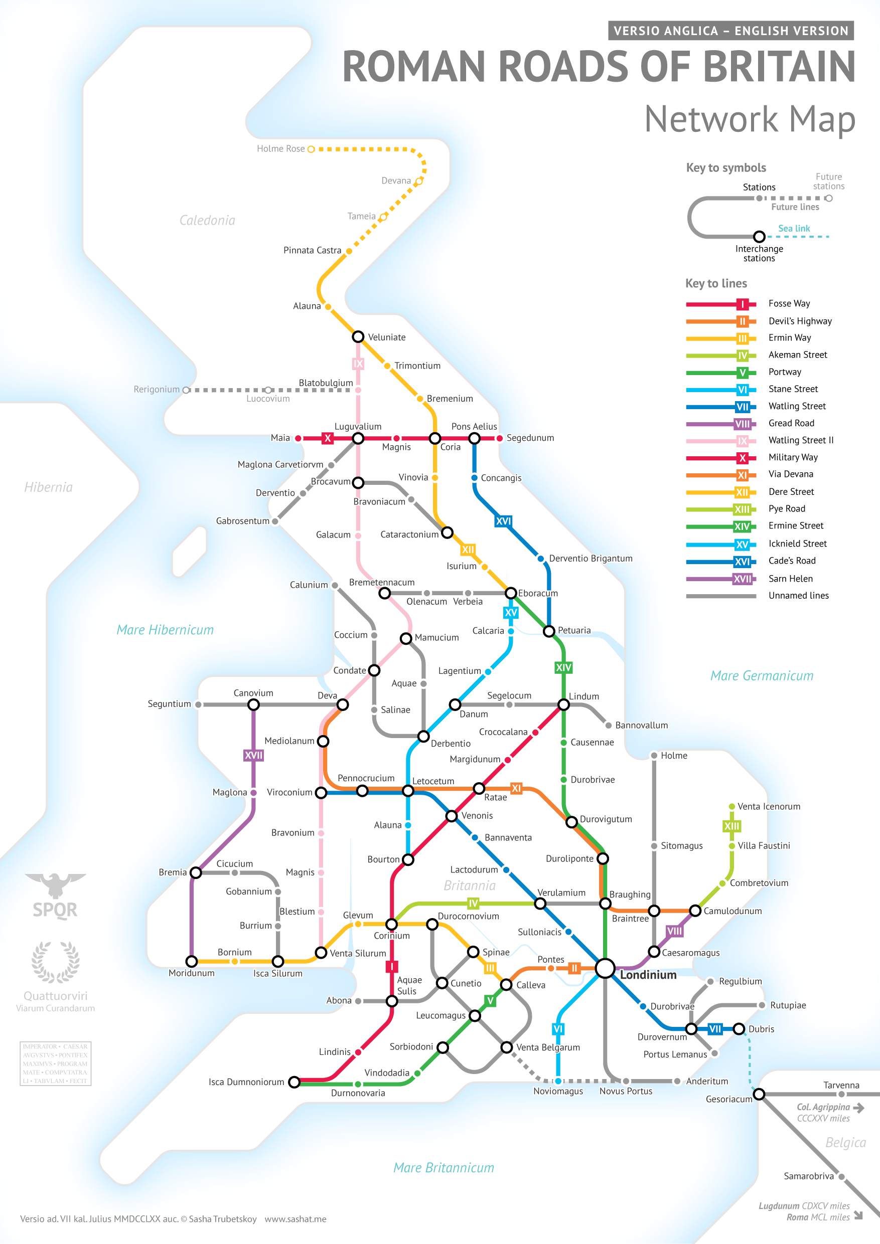
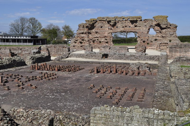
There are fewer NT and EH properties here in the northeast, but the region has so much to offer with possibly some of the most spectacular landscapes in the country: coast, river valleys, moorlands, mountains, and a huge dose of history, especially the history and remains of the Roman occupation almost 2000 years ago.
March 2021 saw us move into our new home in Backworth, North Tyneside, and 15 minutes on the Metro from Newcastle city center. We are also just 10 minutes’ drive from the North Sea coast. The Tyne and Wear area (comprising the five metropolitan boroughs of Newcastle, North Tyneside, Gateshead, South Tyneside, and Sunderland) as well as the surrounding counties of Northumberland and Co Durham (even as far south as North Yorkshire) have so much to offer.
And since our move here in 2020, we have been out and about exploring our new home whenever the weather permits.
On this map I’ve marked all the places we have visited over the past 30 months. NT and EH properties have a dark red icon, coast and landscapes are green, other attractions are purple, and other historic sites are marked with a yellow icon. I’ve included photographs, and there are links to my blog posts and other websites where you can find more information about this wonderful corner of England.
So far, Steph and I have managed to avoid COVID-19. We still mask when we shop at the supermarket, when we travel on the Metro here in Newcastle upon Tyne, or anywhere we might be in close proximity with others. Mostly we are the only ones wearing masks.
And while most people feel that the pandemic is over and done with, latest data from the UK’s Office for National Statistics indicate that the virus is, once again, on the increase.
About 1 in 40 of England’s population (2.66%) tested positive at the end of March. COVID-19 has certainly not gone away, and given some of the horror stories circulating about the effects of long-COVID, it’s better to avoid infection if at all possible. Or at least reduce the risk of infection. That’s why we continue to mask.
And while we have been COVID-free, it has affected our nearest and dearest. Both our daughters and their families were struck down on a couple of occasions, even though everyone had been vaccinated.
As for Steph and me, we received our initial vaccinations in February and April 2021, with boosters in October that year, and in September a year later.
At New Year 2020, who would have envisioned that we were on the verge of a global pandemic. It was only on 31 December that the World Health Organization (WHO) was informed of a cluster of cases of pneumonia of unknown cause detected in Wuhan City, Hubei Province, China. A novel coronavirus (SARS-CoV-2) was subsequently identified from patient samples.
Less than a month later, two Chinese nationals staying at a hotel in York tested positive for coronavirus. It was downhill thereafter, with the first lockdown coming into force on 26 March 2020. Other lockdowns followed. The Institute for Government has published an interesting timeline of the various government measures taken over the subsequent year here in the UK.
Daily life for everyone changed overnight. Although with hindsight, we now know that not all the rules that governed the lives of millions throughout the country were followed by then Prime Minister Boris Johnson and 10 Downing Street staff!
Boris Johnson partying with Downing Street staff.
So, in retrospect, how has the COVID pandemic affected us?
Surprisingly little, if I’m honest. Despite all the inconveniences to daily life, the past three years have flown by. We’ve been rather busy. We kept to ourselves.
Another type of Corona . . .
Fortunately, we prefer the quiet life and since we don’t go pubbing, clubbing, or eating out regularly, we didn’t miss those during the lockdowns. And since the rules permitted exercise outdoors with one person in the same family bubble, we continued to enjoy the outdoors, with Steph joining me on my daily walks around Bromsgrove in Worcestershire where we were living at the time, weather permitting.
And once the National Trust started to open up once again, we seized the opportunity and headed off, on a glorious afternoon, to Dudmaston Hall in Shropshire, and several other properties close by before the end of September.
At Dudmaston Hall on 24 June 2020.
The first impacts of lockdown back in 2020 seem almost a lifetime ago. Deserted streets, and long queues at the supermarkets and shortages (caused primarily by panic buying in the first instance) of some food items and other basics like hand sanitizer and toilet rolls, until the inevitable rationing that was brought in.
Our nearest supermarket, Morrisons, was just 5 minutes or 1.6 miles away by car. Being the driver, the weekly shop fell to me since the supermarkets were only permitting entry to one person per household. I also took on the weekly shop for a widower friend and former University of Birmingham colleague, Jim Croft (a few years older than me) who lived close by. In fact I continued to shop for Jim right up till the day we moved north to Newcastle.
And talking of moving, by November 2019 (during a visit to our younger daughter Philippa and her family in Newcastle upon Tyne) we had bitten the bullet and decided we’d put our Bromsgrove house on the market, and make the move north.
Having appointed an estate agency (realtor) to handle the sale of our house, we waited until the New Year for the first adverts to be placed in the local press. Come mid-January 2020, a For Sale board had been firmly planted in our front garden, and we sat back waiting for a surge of prospective buyers. To our surprise—and disappointment, given the location of our house (proximity to excellent First and Middle schools, close to Bromsgrove town center, nearby dental and medical practices, and an upgraded commuter rail service into the center of Birmingham) we expected there would be more interest than we actually experienced.
By the end of March when the first lockdown came into effect, we’d received fewer than ten viewings. Even under lockdown, the government rules permitted house viewings to continue, as long as they were managed safely (social distancing, hand sanitation, and the like; we were always away from the house in any case during the viewings that were managed by the estate agent).
However, we decided not to accept any more viewings until the rules had been relaxed. Except for one, that had been pencilled in for a week hence. After that, we sat back, wondering when we would finally be able to make the move to Newcastle. We had already decided to rent a house there in the first instance, and use it as a base to look for a new home. But until we had sold our house, it was impossible to make any progress on finding a suitable rental property.
Come the lifting of the lockdown at the end of May, almost immediately we received a request for a second viewing from that last couple. And after a little negotiation, they made an offer which was acceptable. Less than the house had been advertised for (which I never expected to get) but considerably higher than a couple of offers we did receive earlier on, or how other estate agents had valued the house. Happy times! Or at least I thought so.
But anyone who has struggled through a house sale (and purchase) will know and understand the considerable angst that the whole conveyancing process can bring. We were at the top of a chain, since we had no purchase waiting to be completed. There was one solicitor two links below in the chain of four who made life miserable for everyone. By the end of September, however, we had all exchanged contracts and completed the sale on the 30th. And moved out that same day. We had used the intervening months to pack many of our belongings and upcycled many items that we no longer wanted to hold on to.
Fortunately I had identified a nice three-bedroom house east of Newcastle in the Shiremoor district of North Tyneside, and just 10 minutes from the North Sea coast. Offering to pay six months rent up front, I had secured a ‘reservation’ on the property at the beginning of September, not knowing exactly when we would be able to move. We moved in on 1 October.
The removal van arrived at 1 pm and was on its way south once again by 4 pm.
Within a fortnight of landing in Newcastle, we had already made an offer on a four bedroom, and two-year-old house, about a mile from where we were living at the time. It should have been the simplest sale/purchase but once again the solicitors made a meal of the process. However, the purchase was completed on 13 February 2021 and we moved on 6 March.
Moving out of Cloverfield
Moving into our new home
But because of repeated lockdowns, and the rules around meeting other family members and the like, we saw very little of our younger daughter and her family for the next 12 months. Christmas morning 2020 was enjoyed outside in a socially-distanced garden, followed by a solitary lunch for Steph and me.
Unfortunately COVID also put paid to family Christmases in 2021 and 2022.
There hasn’t been a day since that we have regretted the move north. Northumberland is an awe-inspiring county. Our home is only 10 minutes from the North Sea coast. There are miles and miles of paths and bridleways (known locally as ‘waggonways’) on the sites of old mine workings and rail lines. So even just after we moved here, and given the right weather, we have headed out into the countryside, enjoying what we like best: visiting National Trust and English Heritage properties (of which there are quite a few up here with magnificent gardens and walks), and enjoying the fresh air, socially-distanced of course. Just type Northumberland in the search box or open my National Trust and English Heritage page (organized by regions) and you’ll discover for yourselves some of the magical places we have visited over the past two and a half years. Here is just a soupçon of some of those around the northeast.
Seaton Sluice harbor.
The beach at Seaton Sluice.
National Trust Seaton Delaval Hall
National Trust Dunstanburgh Castle
Druridge Bay
English Heritage Warkworth Castle in April
National Trust Cragside
The garden at Cragside
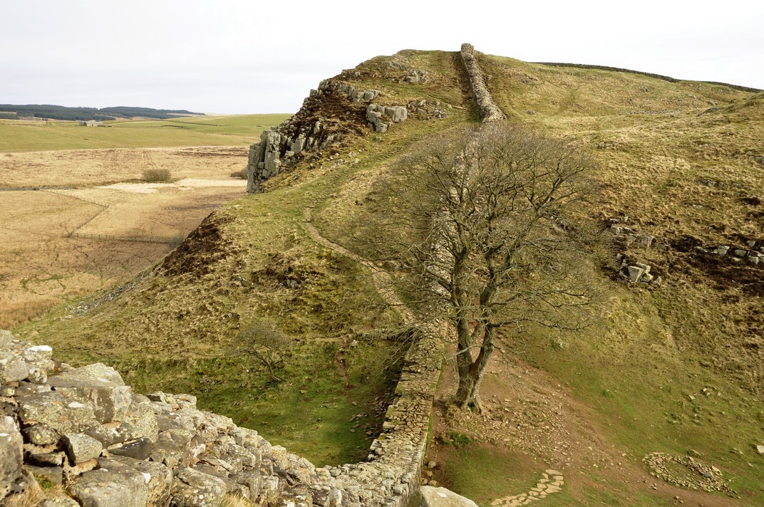
Sycamore Gap on Hadrian’s Wall, in February 2022 just before vandals felled this iconic tree.
The Whin Sill along Hadrian’s Wall
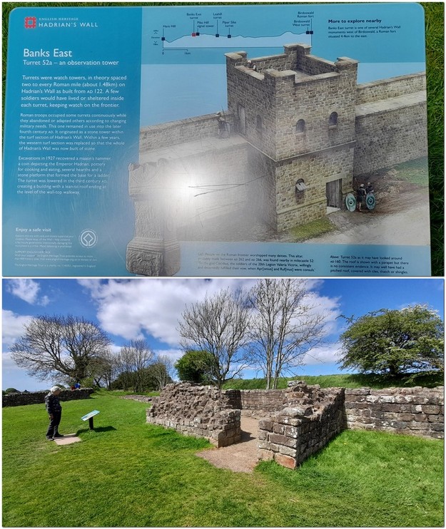
Underfloor heating at Chester’s Roman Fort (English Heritage)
The River North Tyne at Chester’s Roman Fort
Crossing the River Tyne at Ovingham
National Trust Thomas Bewick’s home at Cherryburn
National Trust Allen Banks
Whitburn close south of the River Tyne
Marsden Cliffs south of the River Tyne
National Trust Souter Lighthouse
The Millennium Bridge in Newcastle
The Tyne Bridge, Newcastle
Grey’s Monument, Newcastle city center
Grain stores at Corbridge Roman Town, National Trust
Corbridge Roman town,
Elsdon castle – 11th century motte and bailey
Elsdon Castle
St Mary’s Lighthouse.
Bolam Lake Country Park
Shaftoe Crags
English Heritage Belsay Hall
Quarry garden at Belsay Hall
Christmas at Wallington National Trust
National Trust Wallington central atrium
Prudhoe castle from the pele yard, English Heritage
Upper Coquetdale
Chew Green, Upper Coquetdale
Coquetdale
The cascade at the Alnwick Garden
Cherry blossom at the Alnwick Garden
Looking over Coquetdale
The River Tyne at Ovingham
At this time last year, we spent a week in the south of England—staying at a cottage in the New Forest—and visiting more than a dozen National Trust and English Heritage properties, our first proper holiday since the beginning of the pandemic.
We haven’t traveled to the USA since September 2019, but we are gearing up for a visit come the end of May this year.
COVID restrictions for international travel were lifted sufficiently by July/August 2022 for Hannah and family to fly over from Minnesota, and at last (and for the first time since 2016) we had a family get-together with our two daughters, Hannah and Philippa, husbands Michael and Andi, and grandchildren Callum, Zoë, Elvis, and Felix.
Yesterday, Steph and I took full advantage of our concessionary travel cards to make a round trip by bus to the ferry terminal at North Shields, crossing the River Tyne by ferry to South Shields, and returning home by the metro to our closest station at Northumberland Park.
Our travel concession permits unlimited bus travel after 09:30 each day (nationwide in fact), and with an additional Gold Card payment each of £12, unlimited travel on the local ferry and Metro as well.
The Tyne and Wear Passenger Transport Executive, branded as NEXUS, manages an integrated transport system in the northeast of the UK around Newcastle upon Tyne.
NEXUS brings together the bus, ferry, and Metro services across the five metropolitan boroughs of North Tyneside (where we live) and Newcastle upon Tyne north of the River Tyne, and Gateshead, South Tyneside, and Sunderland south of the river, that together once constituted the metropolitan county of Tyne and Wear.
So, with that in mind, we planned our excursion that would use all three of these services to get around.
Our journey started at 10:25 from a bus stop less than a couple of hundred meters from home. The No 19 service was supposed to operate every hour, although there was some confusion yesterday since a new operator had just taken over the route, and some services did not show up. Ours was about five minutes late, and the journey to the ferry took about 35 minutes.
The journey was quite interesting since it took us through areas of North Tyneside (south of where we live) that we have never explored. It was a little bit longer than we anticipated, since we did not recognise the ferry bus stop, and so stayed on board while the bus completed its route around North Shields before returning to the ferry stop.
We just missed the 11 am ferry to South Shields. But that didn’t matter. Although quite cold (just 2-3°C), it was a bright and sunny day, so we enjoyed exploring the ferry quay and reading about its history before our ferry, Spirit of the Tyne docked around 11:20.
The trip across the Tyne takes about seven minutes, with interesting views along each bank where heavy industries like ship building once thrived. Nowadays some of the land has been converted to choice waterside apartment buildings, although further up river there is an active Port of Tyne, and quays for the ferry service to Amsterdam and where cruise ships also dock. In port yesterday was the Fred Olsen Bolette, preparing for a cruise to Iceland later that same evening.
The ferry quay on the South Shields side is just a stone’s throw from the town center.
We didn’t actually have any plan at all yesterday, apart from making the round trip. But as soon as we had landed in South Shields we discovered that the remains of an important Roman fort (which I had read about but totally forgotten) were less than a mile away. So we headed through the town center to reach Arbeia, on a plot of land known as The Lawes high above the town.
And we were in luck as yesterday was the first day of opening this year. Entrance was free.
Founded around AD 160, Arbeia was a key garrison and military supply base to support the troops who constructed and afterwards manned Hadrian’s Wall further west. The remains of numerous granaries (there were, at one time, up to 24 of these store houses) can be clearly seen from the ramparts of the reconstructed West Gatehouse.
In addition to the gatehouse, there is a reconstructed barracks showing what life might have been like for Roman and auxiliary soldiers all those centuries ago.
The first archaeological investigation of Arbeia began in 1870. More photos of the site and inside the reconstructed buildings (with explanations) can be viewed here.
After a quick picnic lunch, we had a look round the museum, before heading to view the mouth of the River Tyne and across the river to Tynemouth and its priory.
By about 14:00 we had arrived back at South Shields’ new Metro station at the Interchange Square, where we took the metro back home.
South Shields is the end of the line, and just as we stepped on to the platform, the next train was pulling into the station.
Trains from South Shields (yellow line) head into Newcastle city center, before turning east to Whitley Bay and Tynemouth on the North Sea coast and looping back to the St James terminus.
Our stop, Northumberland Park, was 24 stops, and almost 50 minutes. Sitting in a stuffy Metro carriage, surrounded (for part of the journey from South Shields to Jarrow) by a class of high spirited and noisy schoolchildren who we’d seen at Arbeia) was a bit trying, but crossing the River Tyne between Gateshead and Central Station (where the line goes underground for a few stops) and seeing all the bridges downriver always lifts one’s spirits.
About 15 minutes later we pulled into Northumberland Park, and the train headed off on its continuing journey to the coast.
Then it was a short 10 minute walk home, relief at being able to put my feet up (we’d walked about 4½ miles), and enjoy a welcome afternoon cup of tea. All in all, a good day’s excursion.
I always said I’d never buy a house near running water. But that is precisely what we did in February 2021.
The Brierdene Burn is a small stream in North Tyneside, just over 4 miles long (and a catchment of around 3¾ square miles) that flows in a deep ditch close by my house. Fortunately, the ditch is full of plants, and these slow the flow of water considerably. Even during periods of very heavy rain that we experienced recently, the flow didn’t increase appreciably.
That’s because the length of the Burn from its source west of the A19 trunk road (in a field at the top of a slope) to here is less than half a mile, if that.
As near as I can be certain, its actual source is close by the tree in the top image below. In the lower image, the housing development where I live can be seen on the east side of the A19, perhaps only a quarter of a mile away.
From here it meanders eastwards under the A19, through the lower section of Backworth and onwards until it meets the North Sea at Whitley Bay.
The Brierdene Burn meets the North Sea at Whitley Bay.
Just beyond our housing there is an overflow pool, where the Brierdene Burn is joined by a southern, shorter tributary.
Now I’m not sure if this pool was constructed when the houses were built to reduce the risk of flooding, or whether it’s a natural, ‘ancient’ feature in the landscape. The whole area was once covered in coal mines, and maybe the pool was dug when the mines were opened to reduce flooding. I just don’t know.
I often follow the Brierdene Burn and past the pool on many of my daily walks. They are havens for biodiversity, a changing flora throughout the year, and so many different birds. I haven’t seen any mammals in the pool, although I’ve heard reports of otters. I have seen roe deer a little further east.
The Burn flows under Station Road, where common reeds (Phragmites spp.) flourish.
The Brierdene Burn as it emerges from the overflow pool and just before it disappears under Station Road.
Common reed bed.
And in the Spring, the Burn is an excellent habitat for marsh marigolds (Caltha palustris L.) and yellow flag (Iris pseudacorus L.).
Marsh marigolds in Spring, and emerging yellow flag.
And just yesterday, there were the first signs of Spring, with these hazel catkins shaking in the breeze.
A year ago I decided to take photos of the overflow pool every week from two different locations, and make them into these two timelapse videos.
From the dark dismal days of January to the height of midsummer, there is a succession of different species, with a ring of bulrushes (Typha spp., right below) around the perimeter of the pool developing throughout the year and flowering around August, a flush of bedstraws (Galium spp., left below) in June/July, followed by the purple common knapweed (Centaurea nigra L., middle below).
These are some of the birds¹ which I regularly see around the pool all year round.
Heron
Bullfinch
Goldfinch
House sparrow
Song thrush
Magpie
Jackdaw
Starling
Great tit
Blue tit
Long-tailed tit
Coal tit
Robin
Mallard
Moorhen
Pied wagtail
Herring gull
Wren
Carrion Crow
Dunnock
In summer there are some delightful visitors to the pool, and the occasional species that pass through like the little egret and Canada goose.
Reed bunting
Reed warbler
Whitethroat
Canada goose
Little egret
And on the fields along the Burn on the west side, several other species including winter visitors like the redwing, fieldfare, and golden plover, as well as many of those I see beside the pool.
Just the other day, I stopped to take this photo, looking east from Hotspur North towards the pool. And disappointed that folks had decided to drop litter instead of taking it home (an issue I commented on not long after we moved to North Tyneside).
Anyway, just as I took the photo, a small bird flew into a gorse bush beside me. My first reaction was a wren. But to my surprise and delight it was a goldcrest (below), Britain’s smallest bird. I’ve only seen a goldcrest once before and then not very clearly. This one stayed there for almost five minutes, hopping through the branches, and giving me a spectacular view.
There’s always some new delight to inspire me around here. I certainly look forward to exploring more of this fascinating landscape that has come to life 40 years after the coal mines were closed.
¹ Bird photos courtesy of Northamptonshire-based photographer Barry Boswell.
Steph and I joined the National Trust in February 2011, and have now visited more than 130 of its properties in England, Wales, and Northern Ireland, as well as four in Scotland (where Trust members receive reciprocal benefits from the National Trust for Scotland).
I should add we’re also members of English Heritage, but have visited far fewer of its properties.
We’ve certainly had full value from our National Trust joint senior membership over the past decade. We appreciate how visitor policies have developed and adapted to changing expectations over that period, making its properties—and the stories they have to tell—so much more accessible. Its policy on photography (subject to any copyright restrictions) has been relaxed, so that enthusiasts like me can record our visits (no flash!) and then blog about them afterwards.
Here in the northeast of England (where we moved in October 2020), there are fewer Trust properties than in the Midlands (in north Worcestershire) where we lived for many years, and which was a great base for heading out in all directions to explore the National Trust landscape.
Unsurprisingly, the property we have visited most is Hanbury Hall, on our doorstep, near Bromsgrove.
On our last visit to Hanbury Hall in early September 2020, less than a month before we moved to the northeast.
Hanbury Hall was also the first Trust property we visited in February 2011 just after becoming members. We enjoyed all our visits there, most often to take a walk in the extensive park, see how its magnificent parterre changed through the seasons, and occasionally take a glimpse inside the house.
I could write a whole blog just about Hanbury Hall’s parterre.
At this time of the year, however, Hanbury Hall like many National Trust properties have introduced their winter opening schedules, or indeed closing over the next couple of months or so, just opening for special occasions. For many of the properties, Christmas is one those.
And from what we have experienced over the past decade of Christmas visits, the staff and volunteers at the houses really make a great effort to embody the spirit of Christmas.
So as we creep inexorably towards Christmas 2022, here are a few reminiscences of the Christmas visits we have enjoyed since 2013. Sometimes there is a theme for the Christmas display, in others, houses are ‘dressed’ as they might have been when under family ownership. And it’s not hard to imagine just how full of the joys of Christmas many of these properties must have been, children running excitedly about (they had the space!), while parents entertained their guests, all the while looked after by a bevy of household staff. How the other half lived!
Whatever the perspective, grand or modest, these Christmas visits (or just after) are indeed something to nurture the spirit of the season.
In 2020, many houses were still closed due to the Covid-19 pandemic although we had been to Cragside in October and toured the house.
On 14 December visited Wallington in Northumberland. The house was closed, but we enjoyed a coffee outside in the courtyard, and an invigorating walk around the garden and park (although parts were closed due to the tree damage caused by Storm Arwen that hit the northeast at the end of November).
Just over a month ago, Steph and I took the Metro to Cullercoats, a small community between Whitley Bay and Tynemouth on the North Sea coast, just a few miles from home. Our intention was to walk along the beach and coastal path from Cullercoats to Tynemouth, no more than a couple of miles. While we followed much of the coastal path, it’s not possible to show the actual detailed route we took across the beaches on the map below.
Just after we’d climbed out of Cullercoats Bay, and were looking south over Long Sands Beach, I had to pinch myself once again being so lucky to live in such a beautiful part of the country. And with the coast just a few minutes from home.
Looking south towards Tynemouth at Long Sands Beach.
Anyway, back to the beginning of the walk. The Metro ride to Cullercoats took around 10 minutes (just five stops) from our ‘home’ station, Northumberland Park.
To fortify ourselves for the walk ahead, we stopped for a welcome cup of coffee at the Cullercoats Coffee Co., on the corner of Station Road and John St., and only a couple of hundred meters from the Metro station.
It must have been around 10 am, and we were surprised to find the coffee shop heaving with customers, with just one table for two empty on the kerbside. Luckily it was a bright and sunny day, and still quite warm for mid-October.
Cullercoats is a sandy bay enclosed by two piers. It once had a thriving fishing industry, and hosted an artists’ colony in the 19th century, with local fisher-folk often featuring in the paintings.
At low tide (when we visited) there are long stretches of exposed rocks and pools on either side of the bay entrance.
At the base of the yellow sandstone cliffs behind the beach are several caves, known locally as the Fairies Caves. We didn’t venture inside but having now read a little more about them, that’s something we will do next time we visit.
Cullercoats harbor from the south.
Fairie caves at Cullercoats.
And as we climbed over the headland at the south side of the bay we got our first view of Long Sands Beach, and St. George’s Anglican church on Grand Parade.
Long Sands beach between Cullercoats and Tynemouth.
At the south end of the beach is Tynemouth Outdoor Pool, just below Sharpness Point. It has been abandoned since the 1990s. But in its heyday, it was a popular attraction for families enjoying their summer holidays on this beautiful northeast coast.
Source: Newcastle Chronicle
The old Tynemouth outdoor ool.
In Tynemouth, the Grand Hotel stands on Grand Parade above the Pool, overlooking Long Sands Beach.
Built in 1872, there have been numerous famous visitors, among them comedy duo Stan Laurel and Oliver Hardy. Stan Laurel lived in North Shields between 1897 and 1902 and attended the King’s School in Tynemouth.
In 1854, the Italian revolutionary Giuseppe Garibaldi is believed to have stayed in a house that is now part of the King’s School. At least there’s a blue plaque to that effect. The school opened its doors in 1860.
The next bay south, below Tynemouth Priory and Castle (owned by English Heritage) is King Edward’s Bay, just a short walk from the town’s main street, Front Street.
King Edward’s Bay – with the breakwaters at the entrance to the River Tyne visible just beyond the headland.
We headed along Front Street towards Tynemouth Metro station. Since we moved up here two years ago, I’ve seen ‘Front Street’ in many towns and villages. I guess this must be the northeast equivalent of ‘High Street’ further south.
Front Street in Tynemouth is a wonderfully broad street, and although it’s now overburdened (in my opinion) with eating and drinking establishments, it’s not hard to imagine it during its Georgian or Victorian heydays.
Front St from Tynemouth Castle
There’s even a Back Front Street!
Tynemouth’s Metro station is an iron and glass architectural masterpiece, which opened on 7 July 1882 as part of the North East Railway. It’s now a Grade II listed building.
On weekdays, Metro trains run every 12 minutes, so we were home before too long.
And that’s what so nice about living where we do. So many attractions and walks within short distances, and which we can (being retired) drop everything and take time out to enjoy.
You may be wondering about the title reference to ‘lonesome pines’. It’s all to do with Laurel and Hardy.
I couldn’t agree more. Take a piece of distinct Bristol blue glass, or an 18th century air twist glass, for example. Glass is such a beautiful medium—organic even—that when cold and solid seems to retain a fluidity only achieved at high temperature.
I enjoy a wee dram of whisky from time to time. There’s nothing quite like drinking whisky from a finely-cut crystal glass. Taste and touch combining to enhance the overall sensory experience.
If I ever tune into Antiques Roadshow on BBC1, it’s with the hope that glassware expert Andy McConnell (right) might be on the show, and has found an interesting piece of glassware. His enthusiasm for all glass is infectious.
I lived in the West Midlands until two years ago, and knew that Stourbridge was one of the country’s most important glass making centers for centuries. It wasn’t until we moved to the northeast that I discovered just how important the glass industry was in this region since Anglo-Saxon times.
Last Friday, we decided to find out a lot more about glass making and visited the National Glass Centre (NGC), that was opened in October 1998 on the University of Sunderland’s Sir Tom Cowie campus at St Peter’s, on the banks of the River Wear opposite the Port of Sunderland.
So why did Sunderland become such an important center for glass making?
Well, you have to go back to AD 674 when Bishop Benedict Biscop sought help from craftsmen in Gaul to make windows for his newly-founded monastery, the remains of which are still seen in St Peter’s Church (with its original Anglo-Saxon tower) near the NGC. This was where one of Britain’s most famous scholars, the Venerable Bede, grew up.
Between AD 800 or so and 1615, glass making had all but ceased in the northeast. Then King James I banned the use of wood as a fuel for glass production. Given the plentiful supply of coal in the northeast, and that sailing ships coming from the Continent carried ballast in the form of quality sand, glass making was revived here, companies founded, and they prospered well into the 20th century. Sunderland became famous for Pyrex.
Most of the bottle and glassworks have disappeared, closed down, demolished.
But the remants of the industry continue to be washed up along the shore. At the end of August, Steph and I traveled to Seaham, south of Sunderland, to find sea glass on one of the beaches south of the town’s harbor.
Today, the National Glass Centre celebrates the history of glass making in Sunderland and along the Durham coast. When some of the glass makers closed down a couple of decades ago, craftsmen from those companies were hired at the NGC and today offer daily demonstrations of glass-blowing and the like in its workshops, one of which we enjoyed watching after lunch.
Exhibitions are mounted in the main gallery on the upper entrance level. And at the time of our visit, there was a display of many of the pieces that have emanated from the studios of Neil Wilkin and Rachael Woodman. Such remarkable artistry, use of color. I was blown away, if you’ll pardon the pun. Pieces are also offered for sale, with the smallest and cheapest being merely expensive (£1800) to other larger pieces beyond my pay grade, several times over. They are remarkably beautiful. Here is just a small selection of the pieces on display.
Exhibition at the National Glass Centre, Sunderland
We opted to take the Tyne and Wear Metro to Sunderland, changing lines (from yellow to green) at Monument on the outward journey, and Heworth on the return.
Our closest station, Northumberland Park is just a few minutes’ walk from home. St Peter’s at the other end is just over half a mile (and 10 minutes) from the NGC.
Nothing could have been more convenient, and much less hassle than driving there.
It was about 45 minutes or so each way, and on the return journey I managed to snap the Tyne bridges in the afternoon sunlight.
Nestling beneath the England-Scotland border in the far west of Northumberland in the northeast of England, Kielder Water (owned by Northumbrian Water) is the largest man-made reservoir in England by capacity (Rutland Water has a greater surface area), holding 200 billion liters, and with a maximum depth of 52 meters.
It took six years (1975-1981) to construct the reservoir, which was first flooded in 1982. The River North Tyne is the primary inflow.
The Kielder Water dam.
The view east down the valley of the River North Tyne from the Kielder Water dam.
View from the dam across Kielder Water towards the England-Scotland border on the hills in the distance.
Kielder Water is surrounded by Kielder Forest, the largest woodland of its kind in northern Europe, managed by Forestry England (an executive agency sponsored by the Forestry Commission).
We have been waiting for a break in the weather to make a return visit. We first visited this area in 1998 during a touring holiday in Northumberland. And then again in December 2017 when we spent a couple of nights in one of the cabins (with our daughter Philippa, husband Andi, and grandsons Elvis and Felix) at the Leaplish Waterside Park along the western shore of the reservoir.
There are paths for walking and cycling right around Kielder Water.
Kielder Water on a cold and calm December morning, looking east towards the dam.
From our home in North Tyneside, it’s just under 60 miles by road to Kielder Water, taking in much of the awe-inspiring Northumberland landscape along the way. Talk about big skies!
We stopped at the Kielder dam to enjoy a welcome cup of coffee; our journey had taken a little over an hour. Then we crossed the dam to a viewpoint on the far side before heading back and continuing our trip north on the western shore.
Less than a mile from the dam we made a slight detour to view the reservoir from Elf Kirk Viewpoint (it’s marked on the map above). What a delight to see the Autumn colors beginning to shine through, particularly all the golden bracken.
The view northeast from Elf Kirk Viewpoint, looking over the small marina at Merlin Brae.
This was the view southeast from the northern end of Kielder Water, with the dam in the distance.
However, the main focus of our trip was the Kielder Forest Drive, a 12 mile toll road (£3) from Kielder village northeast to the A68 road (Newcastle-Jedburgh) just south of Byrness village.
About a mile in, we stopped to take a stroll up the hillside, which ended up being a three mile walk, and climbing maybe a couple of hundred feet. But the weather was glorious, and it was most enjoyable.
Here is a short video taken along the Forest Drive. It’s really remote, and on the day we visited virtually no other travelers apart from some Forestry England employees.
The rough gravel roads reminded me of traveling around Peru all those decades ago, fifty years come January. The Forest Drive certainly passes through some wild landscapes, made even more ethereal in those parts of the forest that have been felled but not yet replanted. A torn landscape. No cellphone signal.
And there was one object we saw on the hills marking the border between England and Scotland. A container with fire retardant fluid to combat any forest fires, perhaps? Or maybe a defence installation, and early warning system the Scots have installed to repel English encroachments once they gain independence. What do you think?
Fire prevention or defence?
Having reached the A68, it was a smooth and direct drive back down to the coast. Here are a couple of videos (below) traveling through glorious landscapes near Otterburn and Elsdon. Why not listen to Kathryn Tickell, an acclaimed exponent of the Northumbrian pipes (and fiddle); the first tune is Kielder Jock.
Steph and I have been Friends of the Alnwick Garden since April 2021, and being only 34 miles north of where we live in Newcastle, we try to visit the Garden every couple of months or so. It’s always nice to see how the Garden awakens in the Spring, flourishes during Summer, and closes down in the Autumn and Winter. And we always enjoy a welcome cup of Americano in the Pavilion Cafe.
However a stroll round the Garden usually takes no more than 90 minutes, so we often try to combine a visit there with somewhere else: on one of Northumberland’s glorious beaches, or deep in the county’s fabulous landscape.
And that’s just what we did last week, heading south from Alnwick to Lordenshaws Iron Age hill fort, south of Rothbury and beyond.
This is the route we took, and I have marked the various interesting sites along the way that encompass various aspects of Northumberland’s history over the millennia. We only stopped at three of these (having visited the others many times before): Lordenshaws, Mote Hills motte and bailey castle at Elsdon, and Winter’s Gibbet high on the moorland beyond Elsdon.
So without further ado, let’s explore what can be seen along this route.
(1) The Alnwick GardenPlanning for the Alnwick Garden began in 1997, with the first phase opening in 2001. It was the inspiration of Jane, Duchess of Northumberland. The land was donated by her husband, Ralph Percy, 12th Duke of Northumberland, and covers 42 acres. The garden is managed by a charitable trust. The garden also includes a display of some of the world’s most poisonous plants, and there is a narrative of how they have been used for various nefarious purposes.
(2) Alnwick CastleHome of the Percy family for over 700 years, and residence of the 12th Duke of Northumberland and his family, the first parts of Alnwick Castle were erected in 1096.
Today, it’s open to the public, although we have never visited. The castle has been the filming location for several movies and television programs such as two of the Harry Potter films, and Downton Abbey.
Leaving the Alnwick Garden, we headed south towards Rothbury on the B6341, with views back towards the coast from the high, heather-covered moors, then descending towards Edlingham and magnificent views over the Upper Coquet valley all the way to the Cheviot Hills and the Scottish border.
The line was closed to passenger traffic in 1930. Freight services continued until 1965.
(4) Edlingham Castle and chapel The castle dates from the 14th century, although there was an earlier manor house on the site dating from about 1300. It was the home of Sir William Felton. The castle was abandoned as a residence in the mid-17th century.
Close by the castle is the 11th century chapel of St John the Baptist. Services are still held in the chapel.
(5) Cragside This must be one of the jewels in the National Trust crown, being the first house in the world powered by hydro-electricity. It was built by Lord William and Lady Margaret Armstrong. What is particularly striking about Cragside, in addition to the magnificent house and its location, is the fact that the Armstrongs transformed an area of high Northumberland heath into a remarkable garden with trees a hundred feet tall or more, something that they would never have seen. We’ve visited there several times, even before we moved to the Northeast in 2020.
Cragside
National Trust Cragside
Cragside
Cragside
(6) Rothbury Proudly proclaimed as the ‘Capital of Coquetdale‘, Rothbury is a small, traditional market town, and a convenient staging post for tourists wishing to explore the surrounding Northumbrian landscape. It was the birthplace, in 1970, of radio and TV celebrity Alexander Armstrong (a distant cousin of the Cragside Armstrongs). In 2010, Rothbury was also the focus of a massive police manhunt.
From Rothbury, the route climbs towards the Simonside Hills. Lordenshaws hill fort is close by. On this section of the route—as from Alnwick to Rothbury—the damage to trees caused by Storm Arwen in November 2021 was very much in evidence.
(7) Lordenshaws Iron Age hill fort and rock carvingsThis was our second visit to Lordenshaws. The Iron Age fort was built around 2000 years ago. There is also a Bronze Age burial mound. Close-by are the cup and ring marks etched in large boulders, and dating from the Neolithic and Bronze Ages, 6000 to 3500 years ago. Also, the views from there over Coquetdale are impressive.
Heading west from Lordenshaws, we traveled below the Simonside ridge before reaching the meandering River Coquet. Then climbing once more before descending into the village of Elsdon, a small hamlet we had visited in 1998 and which, for us, held an interesting story.
(8) Tosson Tower The tower appears in the video above around 5 minutes mark.
It is a Pele tower built in the 14th or 15th century to protect against raiders in this border region with Scotland. It had walls 2 m thick. We didn’t stop as the tower is on private land.
I’d been trying to locate some of the villages we had visited in Northumberland in 1998. And as we entered Elsdon I realized this was one of them. On that holiday we never had a set route, just ending up each day finding bed and breakfast accommodation when and where we could. In Elsdon, we had an evening meal in the local Bird in Bush pub, before retiring for an early night. You can imagine our surprise the following morning when we came down to breakfast to discover that the landlady’s husband, who we’d met the evening before, had suffered a heart attack during the night. A doctor and ambulance had been called and he was in hospital, probably in Morpeth. We slept through the whole commotion!
(9) Mote Hills motte and bailey castle, Elsdon Parking close by the village hall (where the toilets are open to the public!), we walked the short distance up a lane to Mote Hills, the earthwork remains of a late 11th/early 12th century motte and bailey castle, and one of the finest in the country. It’s very impressive, from a distance and close up.
Click on the image below to enlarge.
We had come across the Umfraville family on one of our earlier trips, in Upper Coquetdale, at Harbottle castle. And like the castle at Elsdon, Harbottle was built on a steep mound, the motte. At Elsdon the slopes must be 60° at least, and after struggling up the sides (before we found a much easier exit) I could imagine just how easy the site would have been to defend against unwanted visitors.
Having spent around 30 minutes exploring the remains of this interesting castle, we left Elsdon, and headed southeast to the last stop on that day’s tour of Northumberland: Winter’s Gibbet.
(10) Winter’s GibbetHigh on the moors southeast from Elsdon, and with a magnificent 360° panorama, stands a sinister reminder of a late 18th century crime.
Winter’s Gibbet stands out clearly against the skyline. It a replica of the one first erected in 1792.
It was here that the body of one William Winter was hung in chains and left to rot following his execution (in August 1792 in Newcastle, along with two women accomplices) for the murder a year earlier of an old woman, Margaret Crozier who lived in a nearby Pele tower. It was the custom back in the day to leave the body of a murderer in a place overlooking the scene of their horrific crime. Click on the image below to enlarge.
William Winter was the only criminal to be ‘displayed’ at this gibbet.
From Winter’s Gibbet we headed home, passing on the way Wallington Hall, the village of Kirkharle, and Belsay Hall.
(11) Wallington This is a late 18th century mansion in the Palladian style, that replaced a medieval Pele tower on the estate (the cellars of which are still visible in the basement). It passed to the Trevelyan family in 1777.
We have visited Wallington on several occasions, and enjoyed not only walks in the garden and parkland, but also understanding the links of the Trevelyan family with the pre-Raphaelite Brotherhood of the late 19th century. I have written about our visits in three blog posts.
Capability Brown
(12) Kirkharle Just west of the A696 and about two miles south of Wallington, lies the village of Kirkharle. Birthplace in 1715/16 of the famous landscape architect, Lancelot ‘Capability’ Brown, who I wrote about after a visit to the National Trust’s Croome in Worcestershire. Brown received one of his earliest commissions from Earl Coventry to redesign the landscape at Croome and dig a large lake, the ‘Croome river’.
(13) Belsay Hall and castleThis was one of the first English Heritage properties we visited even before we moved to the Northeast. It lies about 14 miles northwest of Newcastle.
Besides the Regency style house built in the early 19th century, the Belsay estate includes an impressive garden within the quarry from which stone for the house (and castle?) was taken, and the ruins of a 14th century castle, original home of the Middleton family.
There is access to the roof of the tower with good views over the estate and the Northumbrian hills to the north.
Northumberland has something for everyone. I think we’ve hardly scratched the surface in terms of its history. And although we have traveled quite extensively already throughout the county, there is still plenty more to explore. After all, it is 1820 square miles (or 4716 km²).
When we lived in Bromsgrove (in north Worcestershire), we were about as far from the coast as it’s possible to be in England (if you discount stretches of the Severn Estuary).
In fact, the small community of Meriden (yellow icon on the map) near Coventry (just 19 miles north east of Bromsgrove) claimed for hundreds of years, to be the geographical center of England. However, when I did a search online, I came across this Ordnance Survey website. The center of England and Wales is, apparently, on a farm just outside Sutton Coldfield (green icon), about the same distance away from Bromsgrove as Meriden. Almost two years ago, Steph and I left Bromsgrove and moved to the eastern outskirts of Newcastle upon Tyne in the northeast of England, and just over 5 miles (or 10 minutes) from the North Sea coast.
We love it up here in the northeast, and take every opportunity of exploring Northumberland and its glorious coastline. Northumberland boasts some of the best beaches in the country, although the sea is much too cold for the likes of me to even dip my toes.
We’ve spent less time south of the River Tyne, but have enjoyed the various visits we have made to the Magnesian limestone cliffs at Whitburn, Marsden Beach, and Souter lighthouse.
However, earlier in the week we headed a little further south, beyond Sunderland, to explore one of the beaches near Seaham on the Durham Heritage Coast (DHC).
The DHC is a 20 mile stretch of coast from Sunderland south to Hartlepool having emerged from its industrial past to an area worthy of Heritage Coast status with one of the finest coastlines in England. Click on the map to enlarge. Here is a pamphlet.
Viewing the coast today it’s hard to believe that for decades it was heavily polluted, and almost all wildlife was wiped out. All along the coast there were coal mines, and the waste from the collieries was simply dumped over the cliffs (a continuation of the Magnesian limestone found north of the River Wear).
We headed for Nose’s Point and Blast Beach less than a mile south of Seaham harbor. This was the site of the former Dawdon Colliery. It was one of the most efficient and productive pits in the Durham coalfield. Indeed one of the most productive in the country. It finally closed in 1991.
Dawdon Colliery above Nose’s Point and Blast Beach, in 1934.
Blast Beach was once so polluted that it was used as a location for the opening sequences of the 1992 movie Alien 3. It looks very different today.
Blast Beach from Nose’s Point.
Nose’s Point from Blast Beach.
So what is its history? These sign boards tell something of the industrial story of the coast. Click on the image to enlarge.
The wildlife has returned, the sea water is clean, and this has been repeated all along the DHC.
And as much as we just enjoy being out and about, our visit to Blast Beach had a purpose. We came looking for ‘treasure’ – sea treasure. Sea glass, in fact. The beaches north and south of Seaham are world famous for the quantity and variety of sea glass that is washed up with almost every tide.
The northeast is famous for its glass-making industry, and has a long and illustrious history. Today the National Glass Centre is located in Sunderland.
The Londonderry Bottleworks were opened in 1853 on a site close to Seaham harbor, and remained in production until 1921. Vast quantities of waste glass were dumped in the sea close to the beach, and later on in deeper water. Over the decades this glass tumbled with the tides, becoming smooth pieces, almost jewel-like.
Let Paula Newman from Peblsrock in Seaham explain more about sea glass and its origin.
As it turned out, Blast Beach was not the best location to find sea glass, but wherever you are beach-combing for sea glass, it’s not so easy to spot the small fragments of glass among the shingle.
Here’s our small haul for about 90 minutes of combing as we strolled along the beach.
Eventually we reached Frenchman’s Cove towards the southern end of the beach, and made our way up the steep steps to the coastal path that encompasses the whole of the DHC.
Back at the car park, we had a picnic lunch overlooking the North Sea, and then marveled at the Dawdon fossil.
Hunting for sea glass is very compelling; it could almost become obsessive. So I’m sure that it won’t be too long before we find ourselves once again strolling along one of Seaham’s beaches, backs bent, peering at the shingle and hoping that the one piece of glass we hoped for was there at our feet.
Lasting for over 1000 years, from the time of the first Emperor Augustus (Gaius Julius Octavius, 63 BC – AD 14) in 27 BC, its physical legacy can be seen all over Europe, North Africa, and the Middle East.
Julius Caesar
Eventually Britain (Britannia) came under the sway of the Romans. In 55 BC, Gaius Julius Caesar (100-44 BC) led an expeditionary force to this island, returning the following year. But that did not lead to conquest, taking almost another 100 years to complete, under the Emperor Claudius (Tiberius Claudius Drusus Nero Germanicus, 10 BC – AD 54) in AD 43.
What is remarkable in many ways, is that the Roman occupation of Britannia lasted less than 400 years. By AD 410 they had upped sticks and departed.
Less than 60 years after the conquest of Britannia, the Romans built a road network of almost 8000 miles, and in AD 122, the Emperor Hadrian (Publius Aelius Hadrianus, AD 76-138) ordered the construction of a wall across the narrowest part of northern England, from the Solway Firth in the west to the North Sea coast in the east.
Twenty years later, under the Emperor Antoninus Pius (Titus Aurelius Fulvus Boionus Arrius Antoninus, AD 86-161), the Antonine Wall was constructed from turf on a stone foundation, coast to coast, about 40 miles north from Hadrian’s Wall in Scotland. It was abandoned less than 10 years later.
Location of Hadrian’s Wall and the Antonine Wall
Hadrian’s Wall is surely one of the most conspicuous of all Roman remains, anywhere. It still stands proudly, although somewhat diminished, where once it guarded the most northwestern frontier of the empire against barbarians to the north. It was a remarkable achievement, and even today inspires wonder at the effort it took to construct the Wall over the wildest of landscapes.
And we can also wonder about the lives of the men (and women) who were stationed along the Wall and where they came from. It’s not just the physical legacy of the Wall (and other settlements around the country) but also the genetic legacy that the Romans left behind, in their offspring from relationships with local women, legitimate or otherwise. Romans didn’t just come from Rome, but from all corners of the empire even from the easternmost provinces of the Middle East and beyond. The ‘Roman’ genetic signature has obviously been diluted by successive waves of invasion into these islands.
The Romans have left a huge legacy for us all to wonder at. They were road builders par excellence. Roads were needed as the Romans spread out across the country, to maintain communications between towns and military garrisons, to allow troops to travel more effectively and rapidly, and to facilitate commerce. And their roads have endured even today, and some of England’s principal arteries follow the routes of former Roman roads, and are known, in part, by the same names.
I recently came across this stylized map (in the format of the iconic map of the London Underground created by Harry Beck) of the Roman road network that connected towns and cities, and military installations all over.
Even today, Roman roads are still being uncovered. There was a report recently in The Guardian of a road in west Wales that indicated the Romans had ventured deeper into Wales than previously appreciated.
As far as I can recall, the only Roman road I have walked was the Wheeldale Roman road on the North York Moors near Goathland. The exposed part is only about a mile long. The first time was in 1968 when I was at university, and then about 20 years later with my wife Steph and daughters Hannah and Philippa.
We now live in North Tyneside, just 3 miles north as the crow flies from Segedunum, the fort at the the eastern end of Hadrian’s Wall. And with Hadrian’s Wall and other Roman remains so close, we have made quite a number of forays into the Northumberland countryside to explore them.
It’s quite remarkable just how much of Hadrian’s Wall remains, after 2000 years, despite much of the stone having been removed.
Hadrian’s Wall at Sycamore Gap.
The Wall was much higher than remains today, and the Mileposts and Turrets (or observation towers) have been reduced to shells of their former imposing structures.
Milepost 39 near Sycamore Gap.
However, further west beyond Birdoswald, where the Wall was built from turf, the signature of the Wall can still be seen as depressions in the landscape.
Underfloor heating at Chester’s Roman Fort (English Heritage)
Housesteads from the air (Source: English Heritage)
East Gate at Birdoswald Roman Fort
Grain stores at Corbridge Roman Town, National Trust
Vindolanda
Archaeology at Vindolanda
This is a panorama across Corbridge Roman Town.
At Wroxeter, in Shropshire, one part of a basilica wall still stands, and at Portchester the impressive outer curtain wall of the original Roman fort is still intact, 20 feet or more tall. Typical Roman concrete, just like I have seen in Rome itself.
The surviving 7 m high basilica wall (‘Old Work’) at Wroxeter, the largest free-standing wall in England.
The Roman walls of Portschester Castle.
And then there are the civil remains like Fishbourne Roman Palace near Chichester in West Sussex (that I haven’t visited) and Chedworth Roman Villa in Gloucestershire that we have.
And Roman remains are still being uncovered all over England. Not only hoards of coins, but also a beautiful mosaic that was discovered in a farmer’s field in eastern England a couple of years ago, with images of Homer’s Iliad, a unique find. Roman archaeology is thriving.
Then there are all the various artefacts, from jewelry to household items, monuments and statues that were left behind that allow us to paint a detailed picture of life in Roman Britain. Here are some kept in the museums at Corbridge Roman Town and Chesters Roman Fort.
And, in particular, the Vindolanda Tablets, the oldest surviving handwritten documents in this country, have provided a commentary of the lives of soldiers and their families.
The world-famous Vindolanda Tablets
These are some of the most important relics from the period of Roman occupation. And these, and other sites and remains from that time will keep archaeologists busy for years to come.
Following the Norman invasion of England in 1066, there was—for centuries afterwards—an obsession almost for building castles as magnates secured their rule throughout the land, led of course from the top, by the monarch.
Goodrich Castle, Herefordshire
Many of these castles still stand today, mostly as ruins. Some in a more advanced state of dereliction than others. During the Civil Wars of the mid-seventeenth century, many castles were deliberately demolished or ‘slighted‘. But even in their diminished states, these castles still remind us of the power struggles that dominated our landscape for centuries.
As keen English Heritage and National Trust members, Steph and I have visited quite a number of the castles in their care. And since we moved north to Newcastle 21 months ago, we have enjoyed exploring the Northumbrian landscape and the numerous castles (and Roman remains) that can be found there.
Anyway, I thought it might be interesting to map all the fortifications—ancient hill forts, Roman forts, castles, and fortified manor houses—that we have visited over the past decade. Just click on each of the icons to view an image and links to different websites or posts in this blog.
I have color-coded the icons thus:
Black: pre-historic and pre-Roman (pre-AD 43)
Green: Roman (43 – 410)
Yellow: Norman (1066 – 1154)
Red: early and late Plantagenet (1154 – 1399; including one castle in Scotland and another in Northern Ireland)


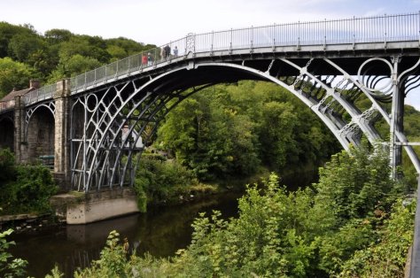
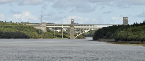

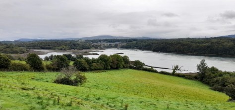
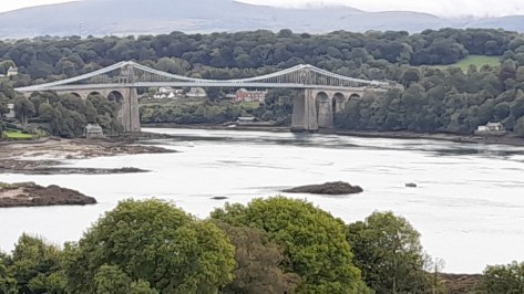


 towards South Shields, Jarrow, and Hebburn on the A185, and a brown sign for Jarrow Hall and St Paul’s, with the English Heritage logo (right) prominently displayed. A road we’d not been down until last week.
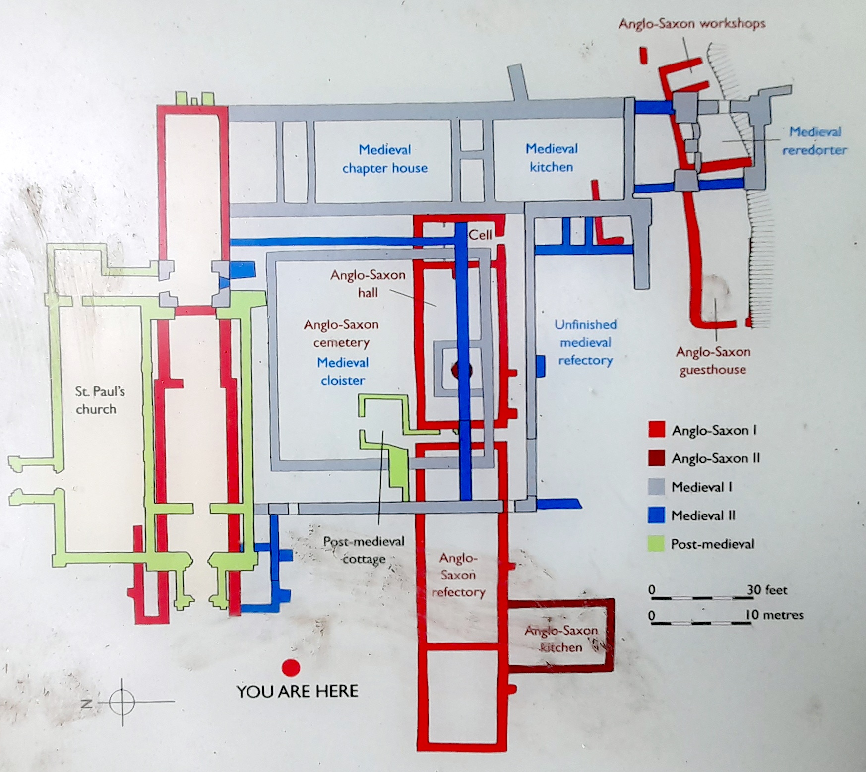
 The church and monastery were built on land given by

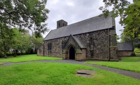


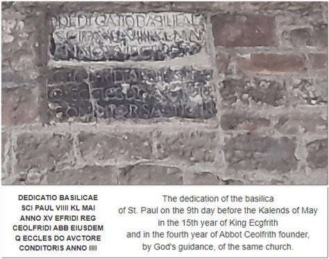


_Hungary")
_2")


 Anyway, the forecast for yesterday seemed hopeful, so we decided to make the short, 22 mile and 30 minute drive south to Durham to take in Crook Hall Gardens. The Trust acquired the property in 2022, and if I understood correctly, it was opened to the public for the first time in March this year.
 Crook Hall was a family home since the 1300s, and occupied over the centuries by several families who stamped their mark on the property. Originally it was the home of the Billingham family for 300 years from 1372. Between 1834 and 1858 it was rented by the Raine family. Canon
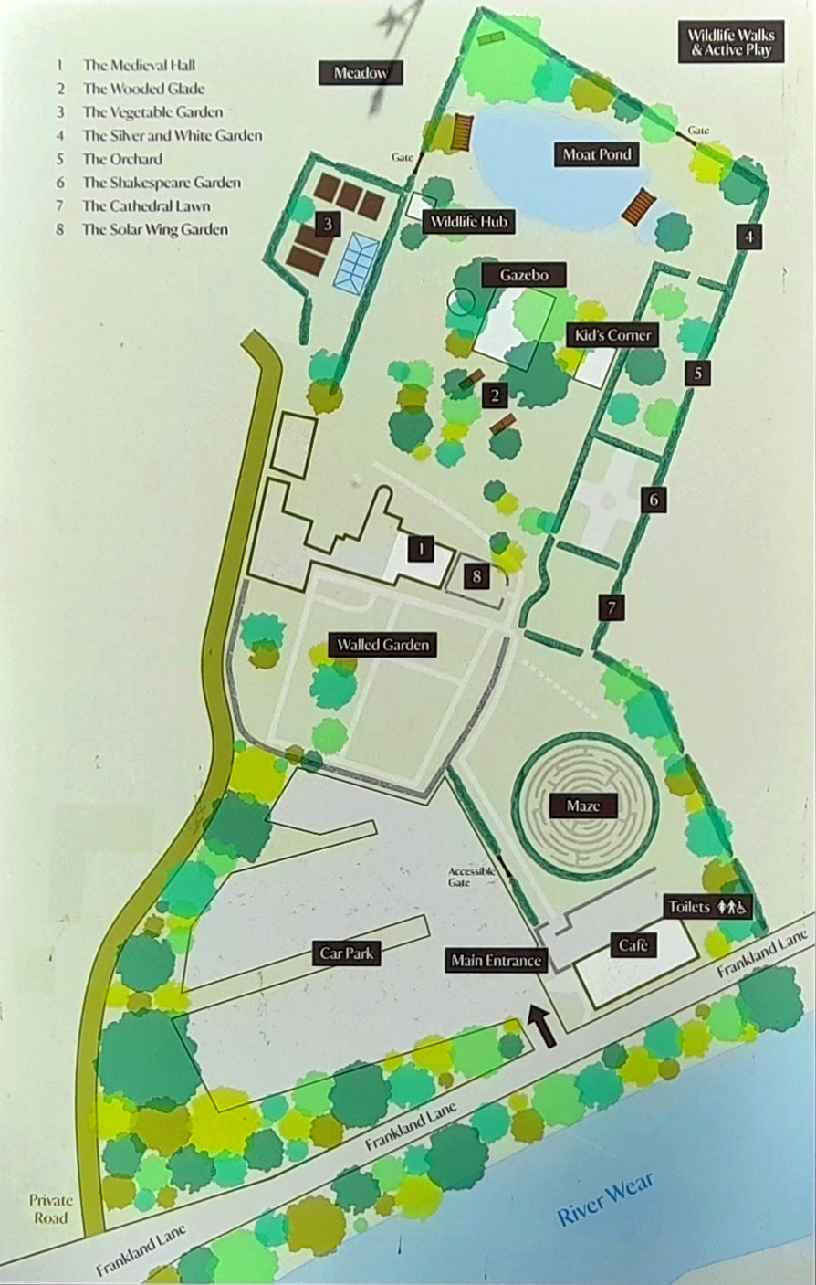


 During the
.jpg")


 I hope I’m not tempting Providence.


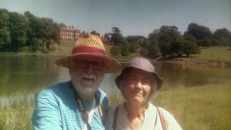
 Our nearest supermarket, Morrisons, was just 5 minutes or 1.6 miles away by car. Being the driver, the weekly shop fell to me since the supermarkets were only permitting entry to one person per household. I also took on the weekly shop for a widower friend and former University of Birmingham colleague, Jim Croft (a few years older than me) who lived close by. In fact I continued to shop for Jim right up till the day we moved north to Newcastle.
 Having appointed an estate agency (realtor) to handle the sale of our house, we waited until the New Year for the first adverts to be placed in the local press. Come mid-January 2020, a For Sale board had been firmly planted in our front garden, and we sat back waiting for a surge of prospective buyers. To our surprise—and disappointment, given the location of our house (proximity to excellent First and Middle schools, close to Bromsgrove town center, nearby dental and medical practices, and an upgraded commuter rail service into the center of Birmingham) we expected there would be more interest than we actually experienced.

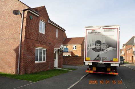


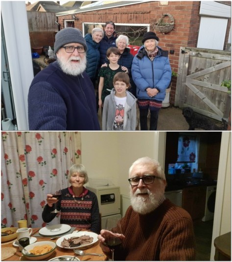


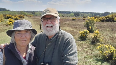
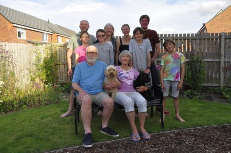


 We didn’t actually have any plan at all yesterday, apart from making the round trip. But as soon as we had landed in South Shields we discovered that the remains of an important Roman fort (which I had read about but totally forgotten) were less than a mile away. So we headed through the town center to reach


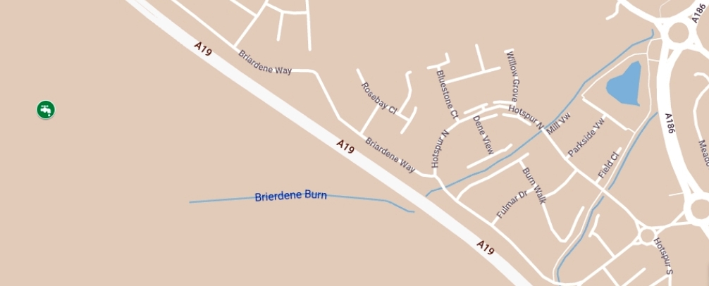


 Just the other day, I stopped to take this photo, looking east from Hotspur North towards the pool. And disappointed that folks had decided to drop litter instead of taking it home (an issue I
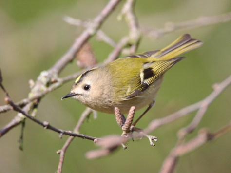
 Steph and I joined the


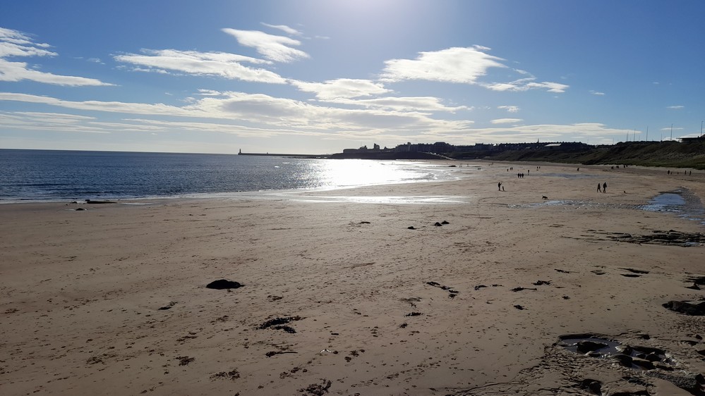


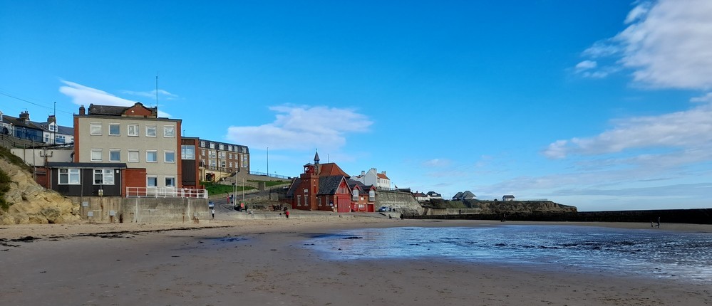


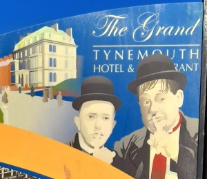 Built in 1872, there have been numerous famous visitors, among them comedy duo
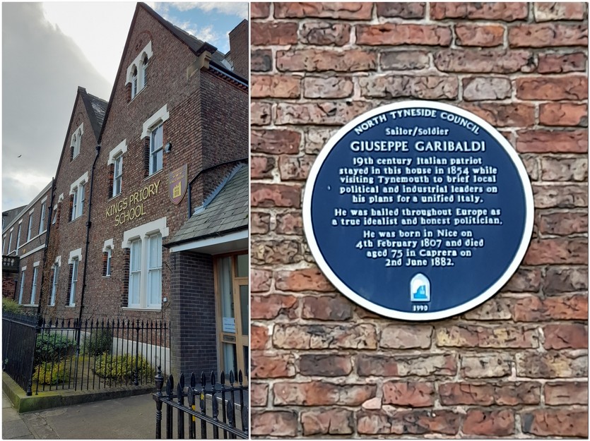


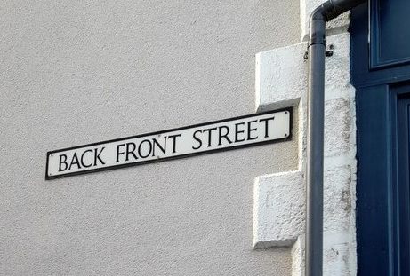


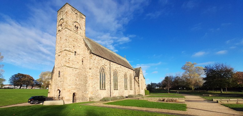

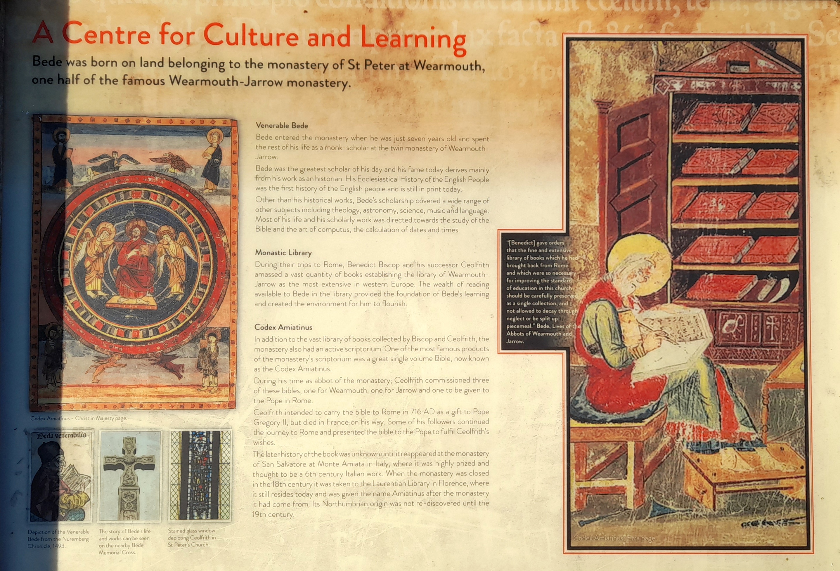

 But the remants of the industry continue to be washed up along the shore. At the end of August, Steph and I traveled to Seaham, south of Sunderland, to find


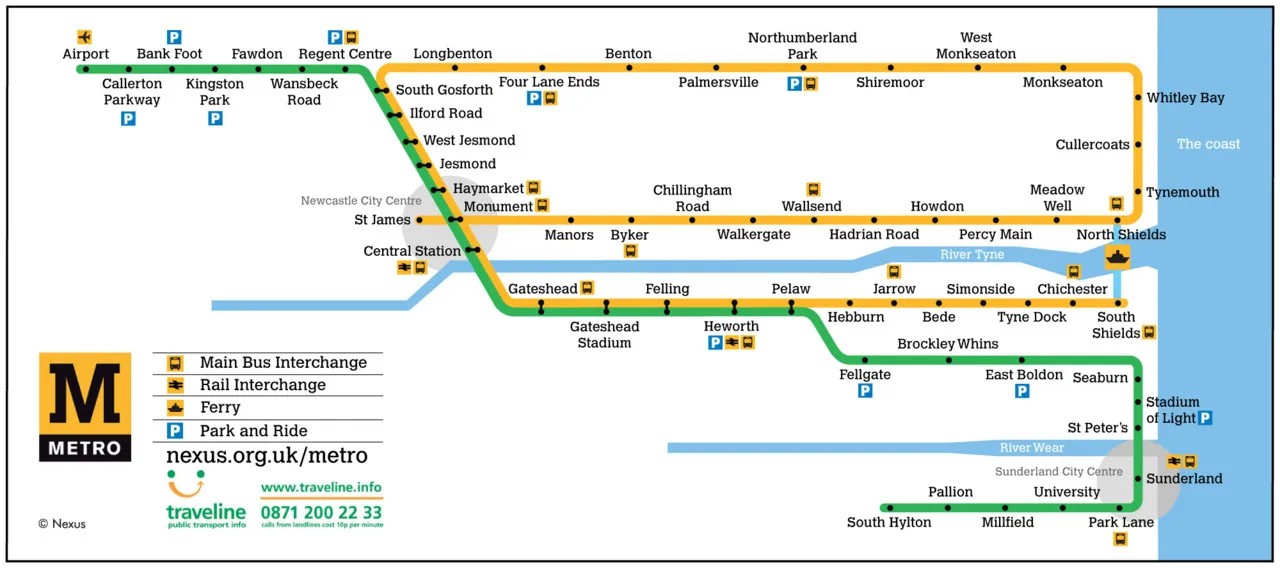


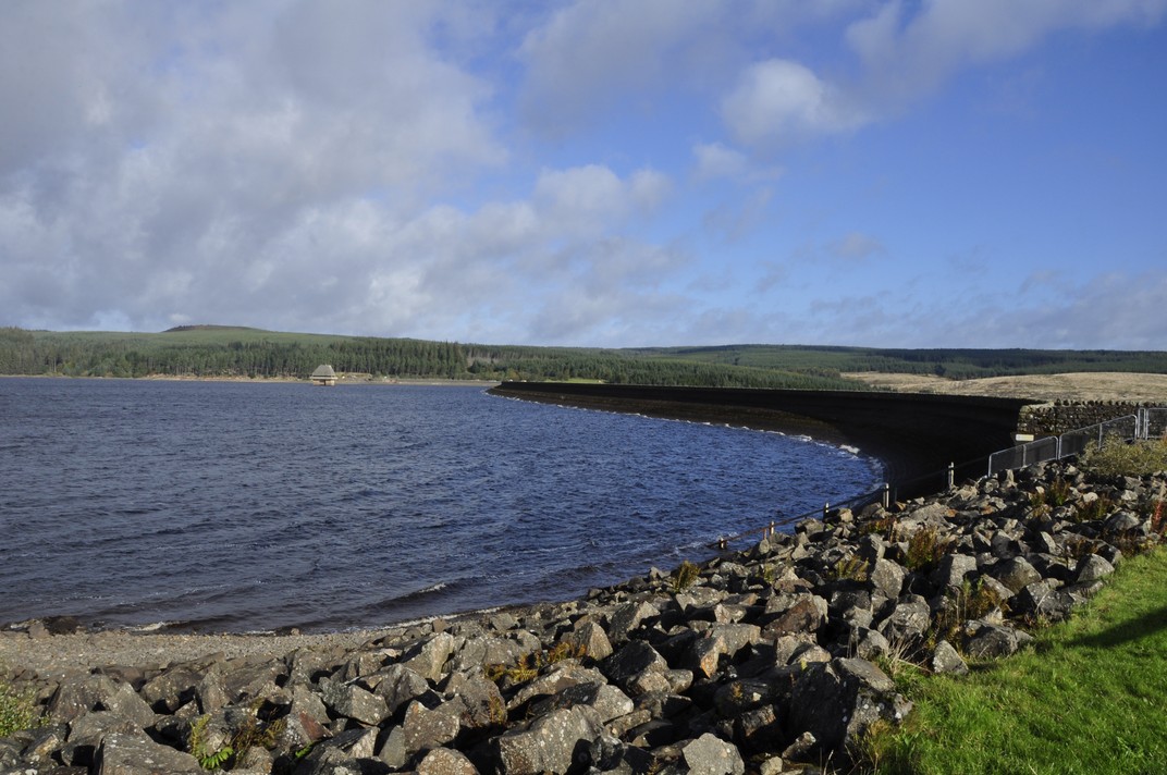
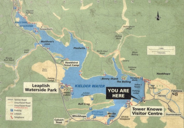
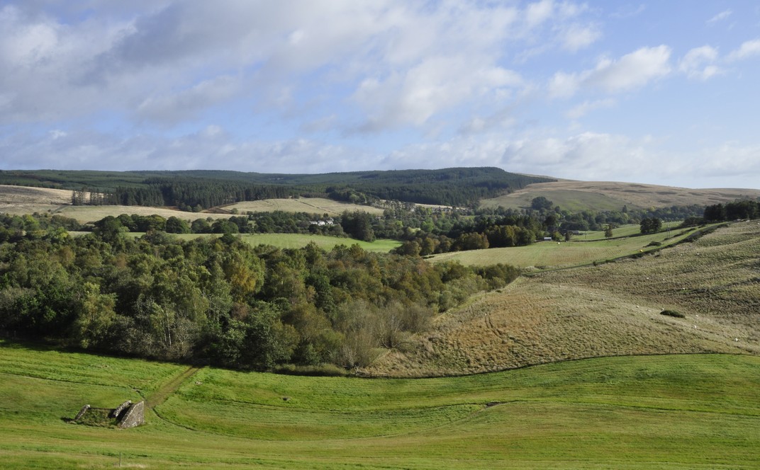
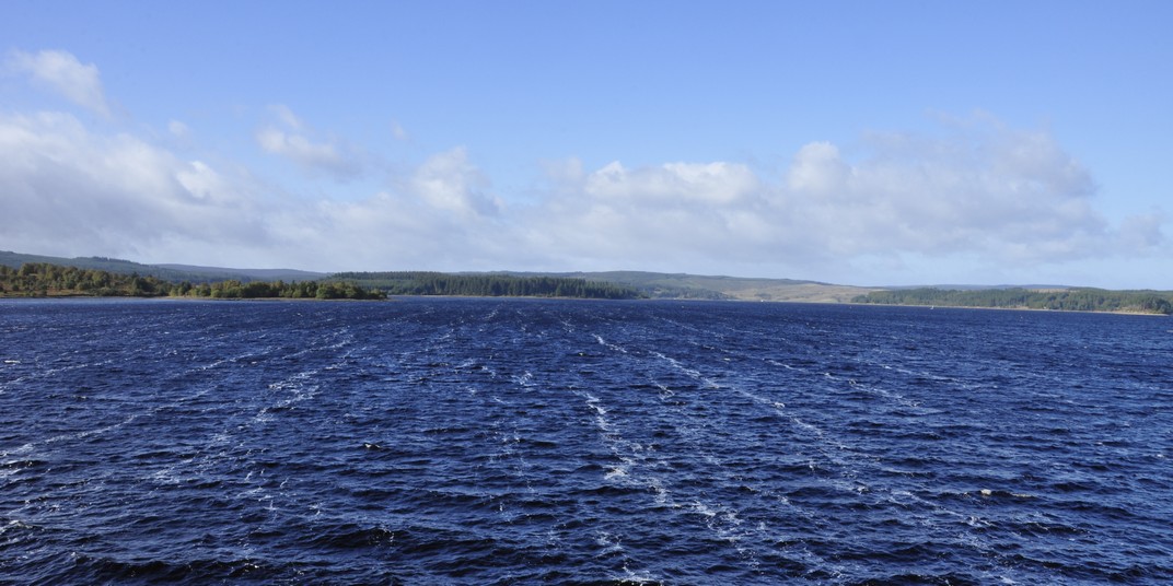


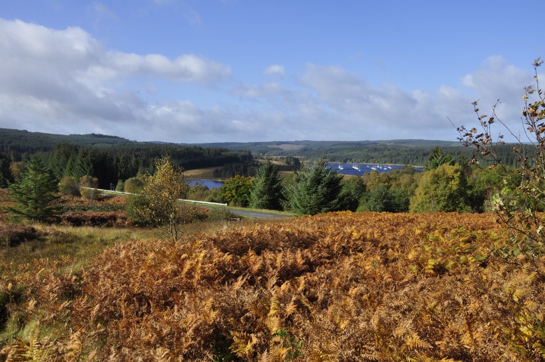


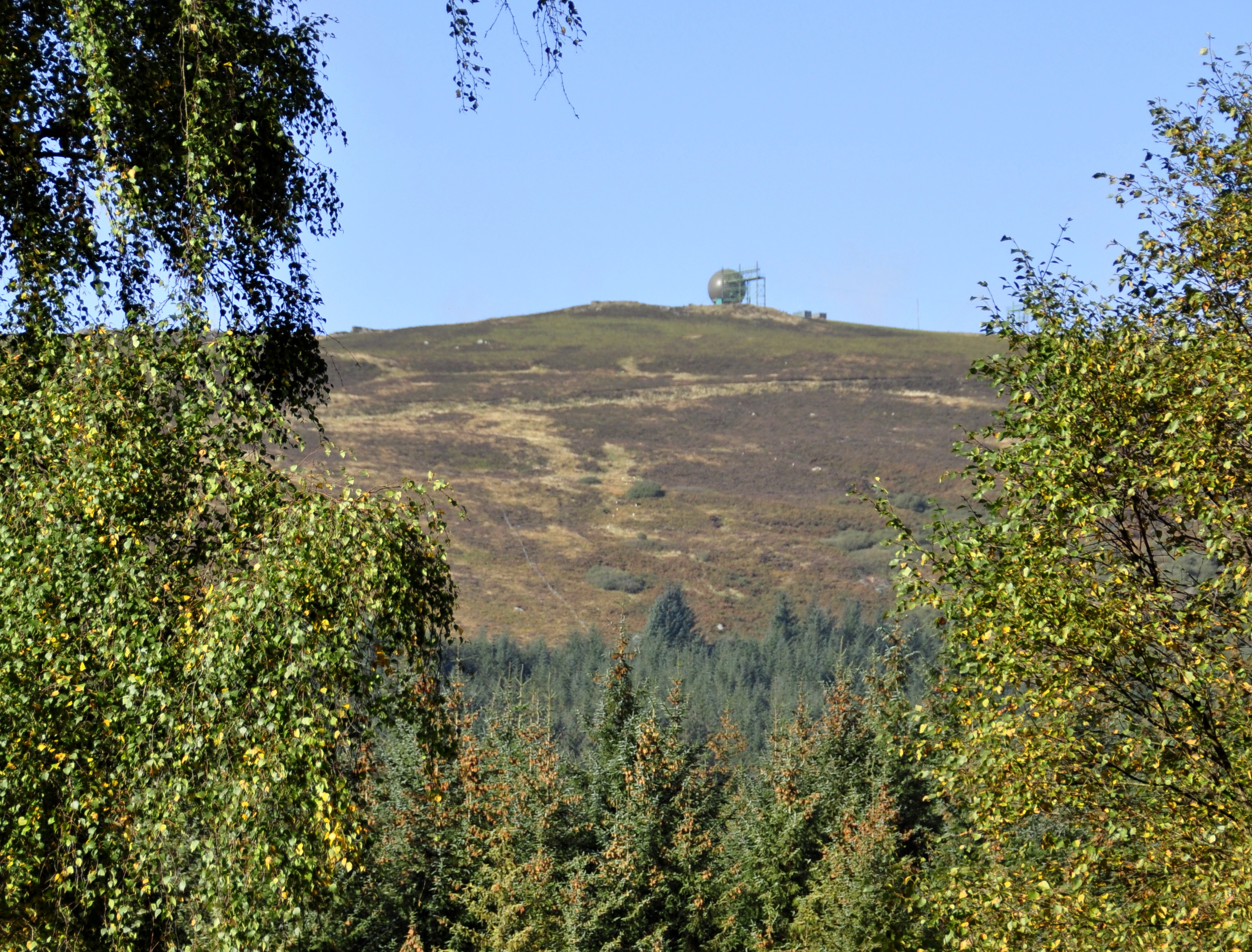
 Having reached the A68, it was a smooth and direct drive back down to the coast. Here are a couple of videos (below) traveling through glorious landscapes near Otterburn and Elsdon. Why not listen to


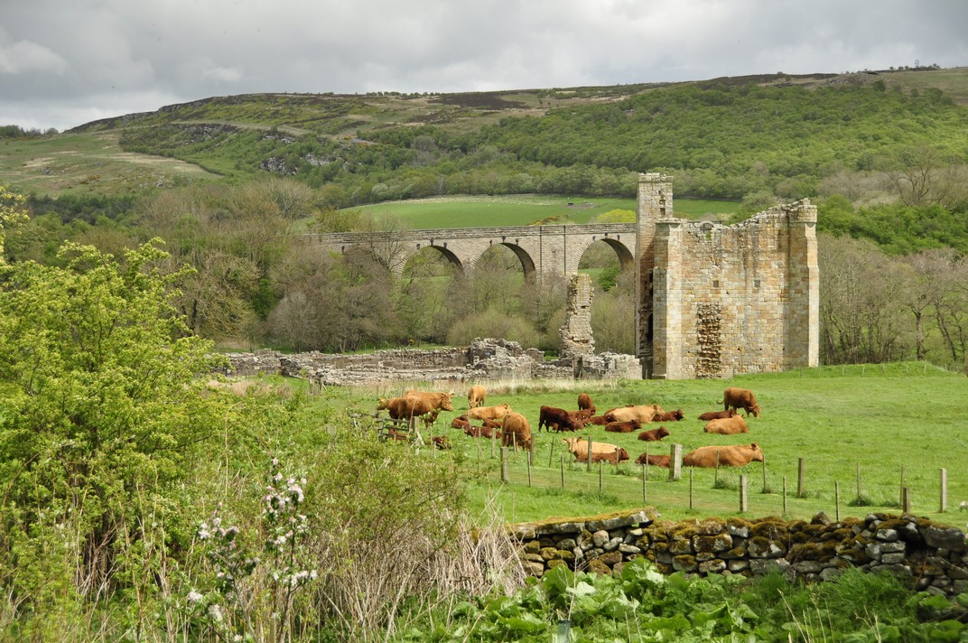


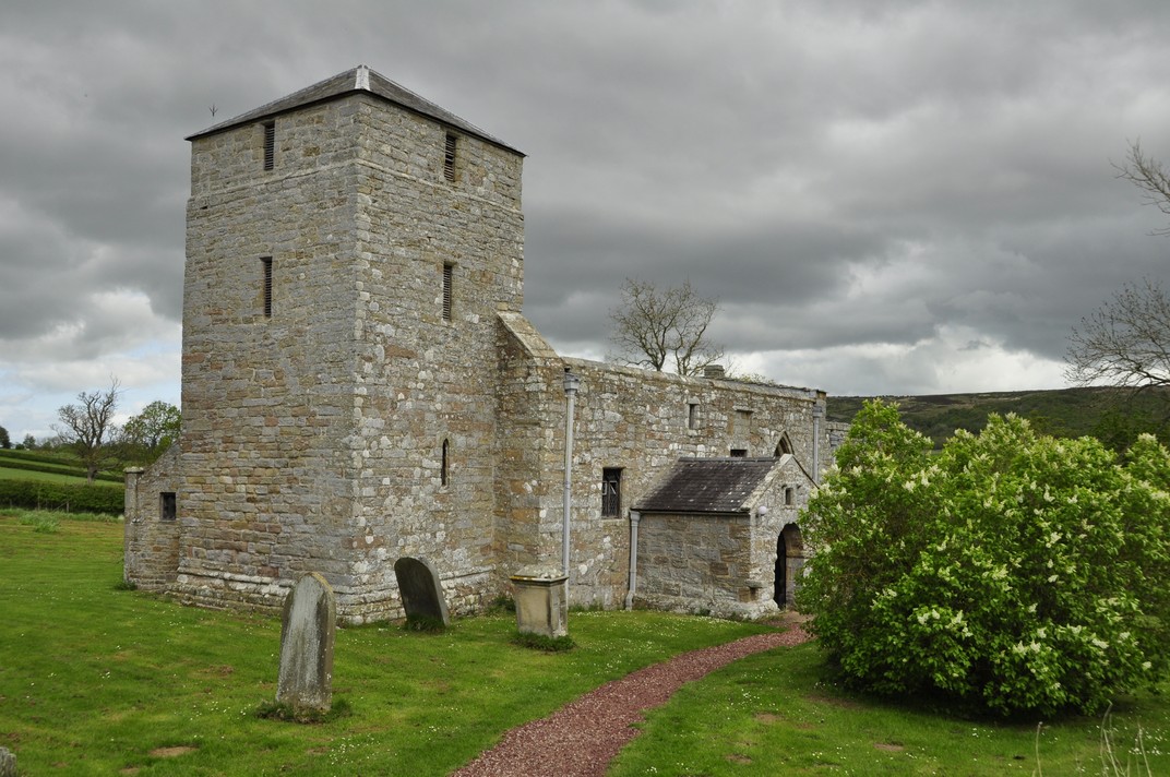


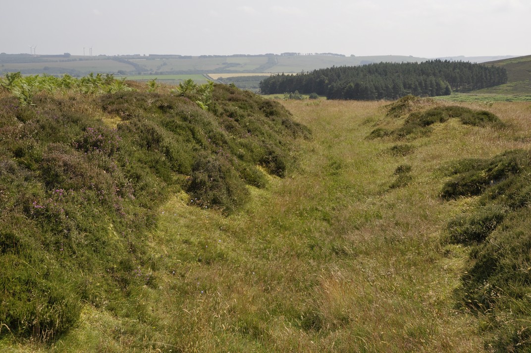
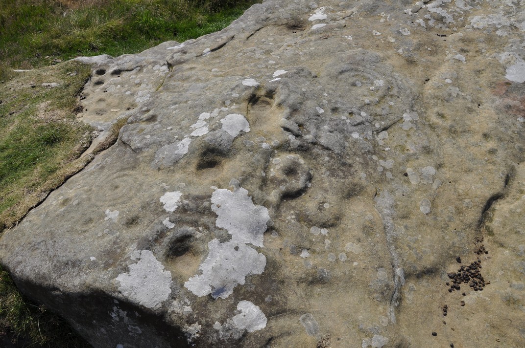
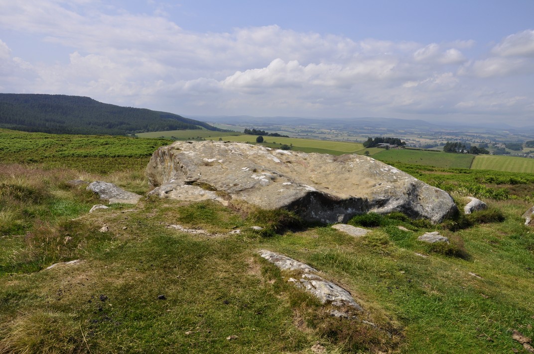

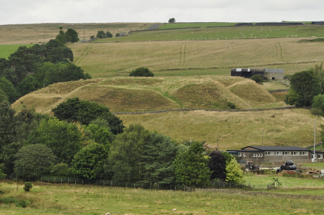
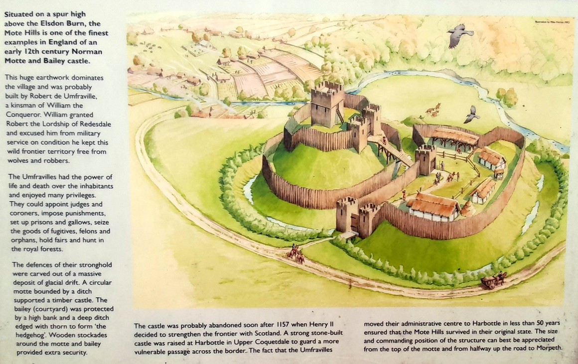
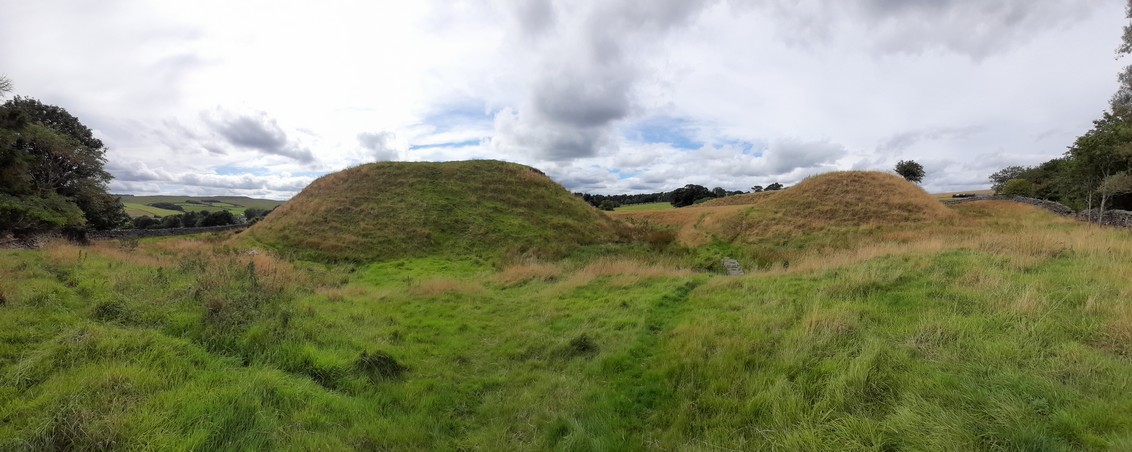
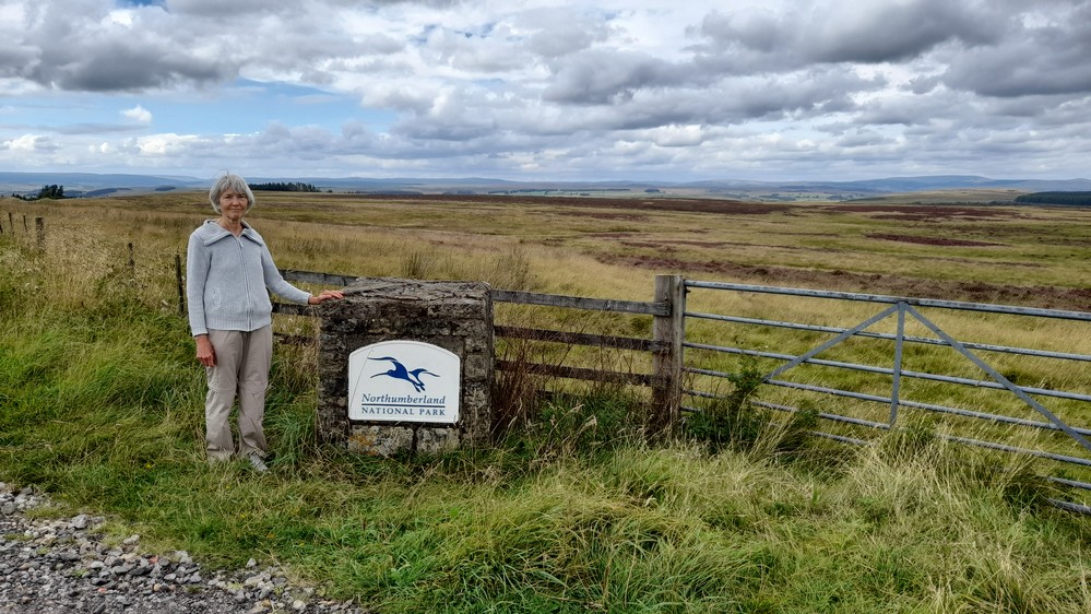
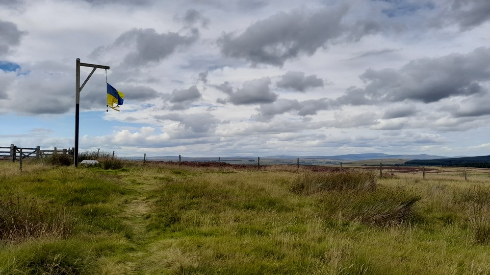
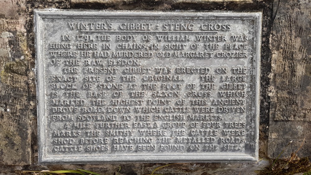


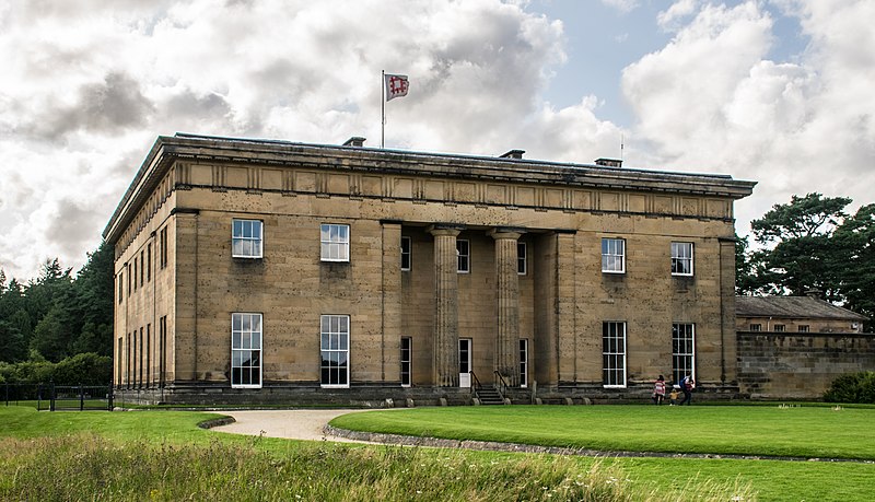
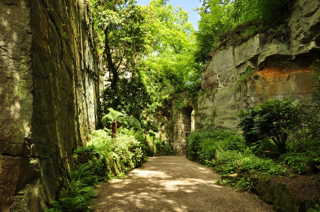
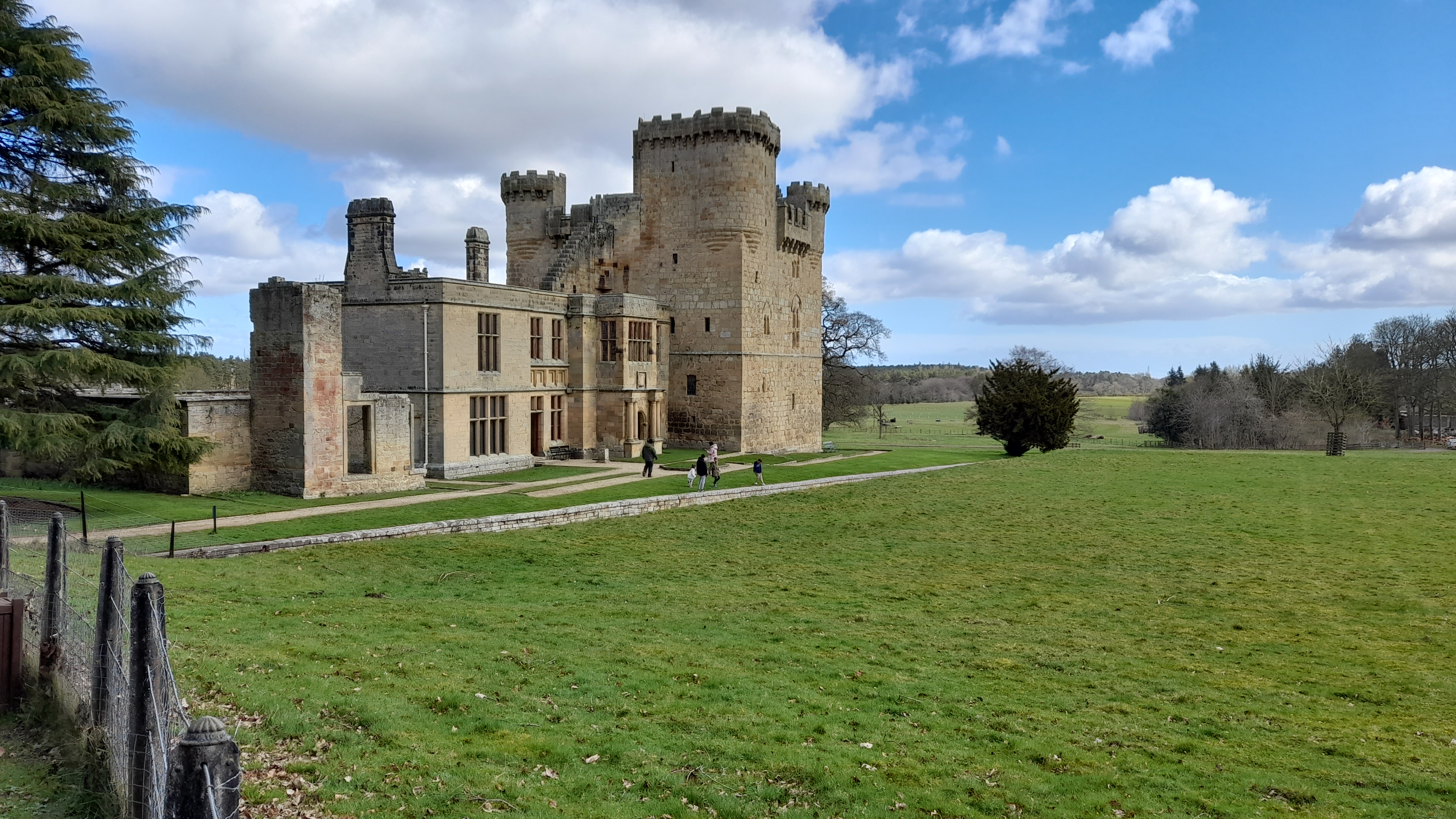
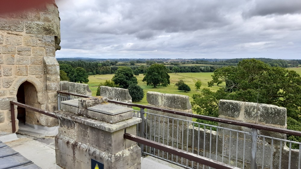
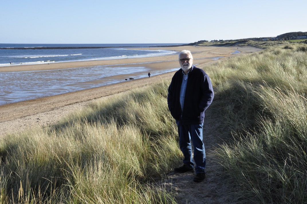

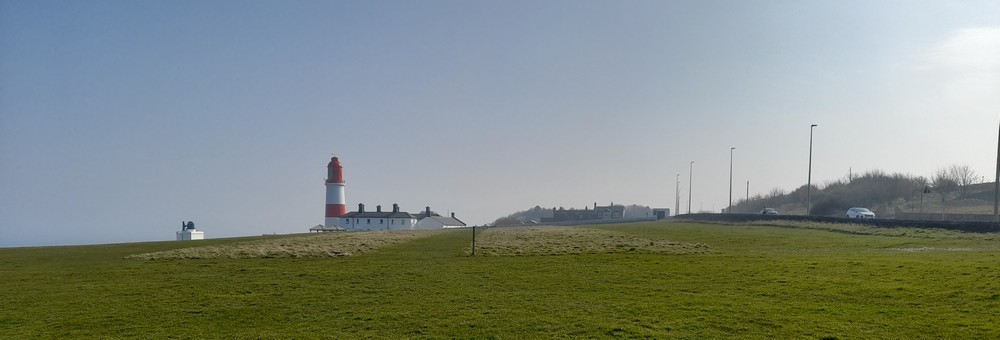


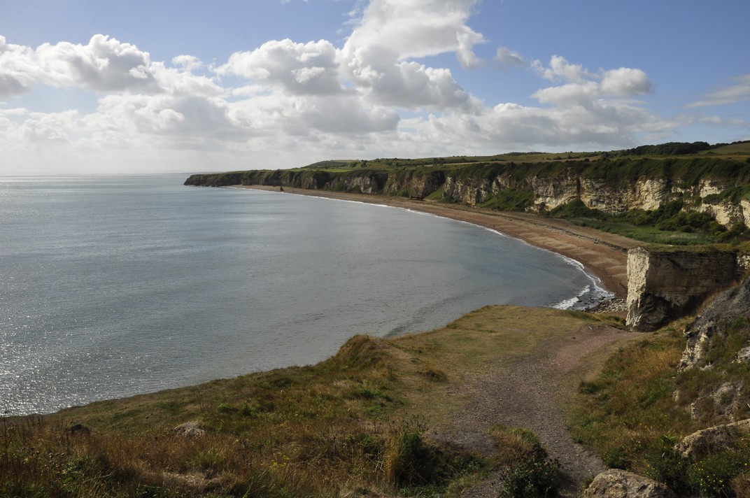

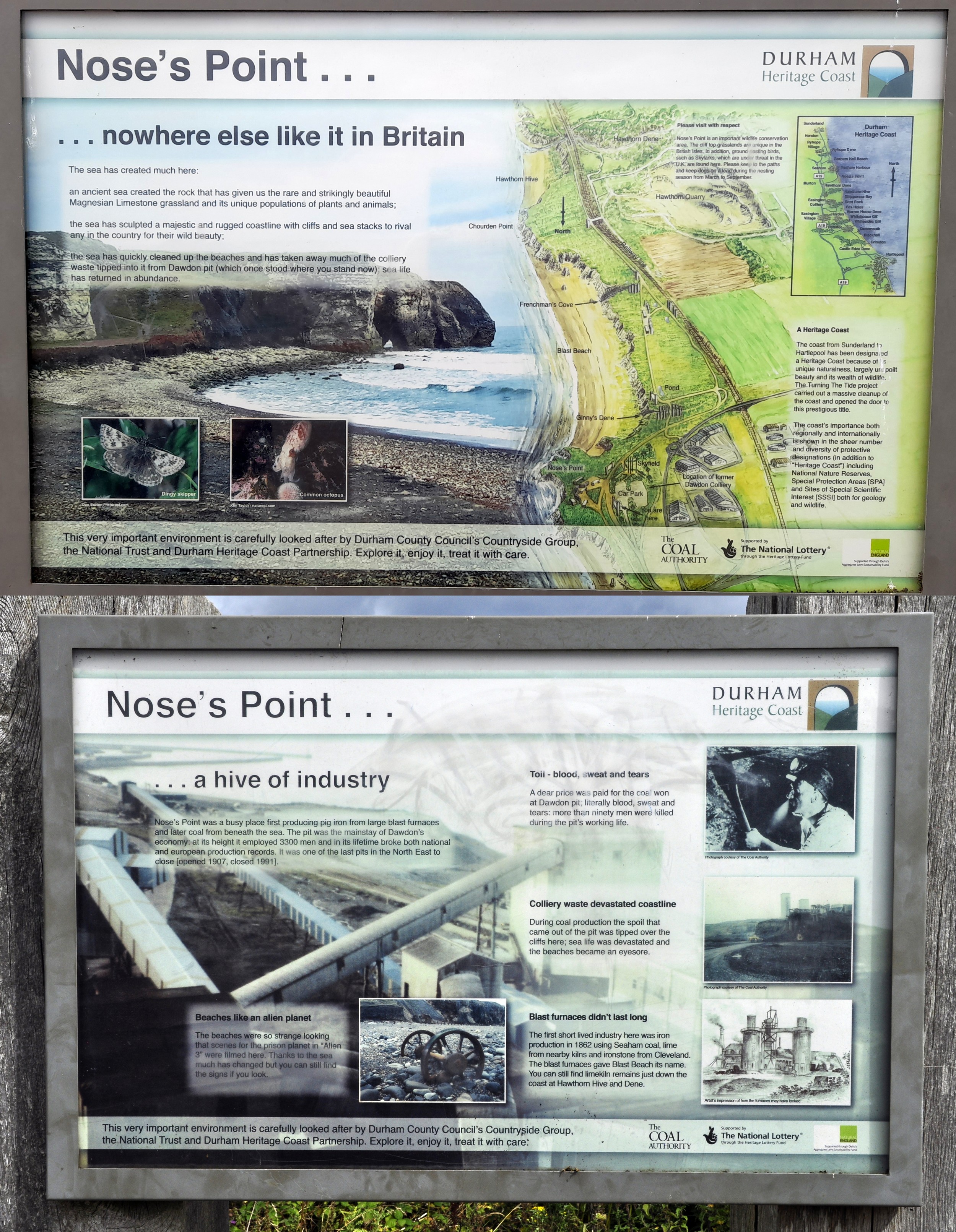
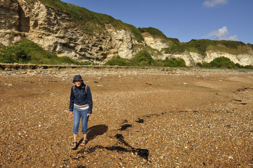
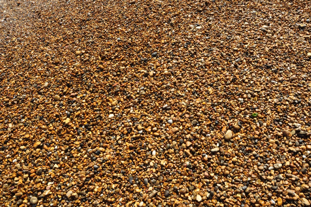
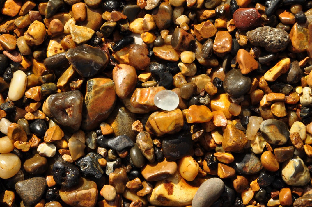


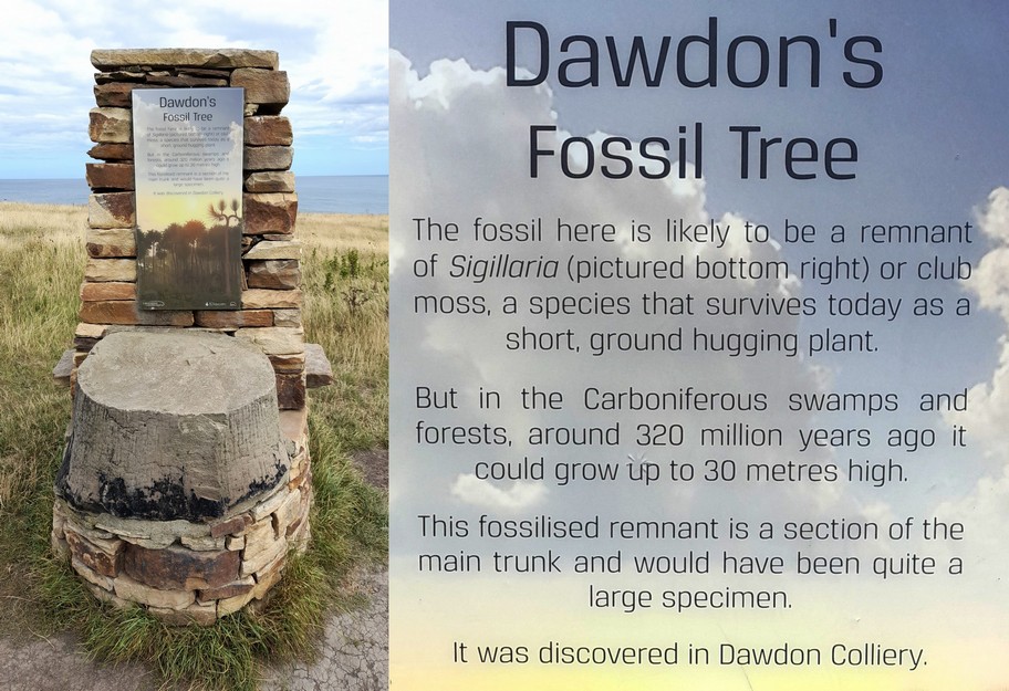


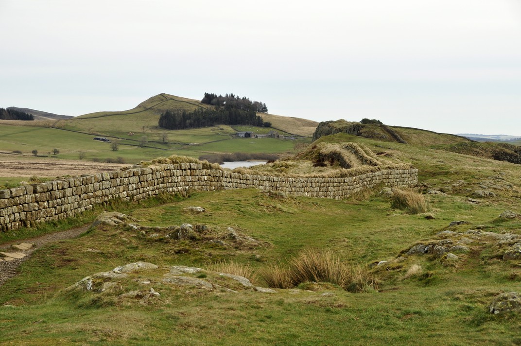
 And we can also wonder about the lives of the men (and women) who were stationed along the Wall and where they came from. It’s not just the physical legacy of the Wall (and other settlements around the country) but also the genetic legacy that the Romans left behind, in their offspring from relationships with local women, legitimate or otherwise. Romans didn’t just come from Rome, but from all corners of the empire even from the easternmost provinces of the Middle East and beyond. The ‘Roman’ genetic signature has obviously been diluted by successive waves of invasion into these islands.