The River Tyne is actually two rivers, North and South, until they converge at Warden Rock, a couple of miles west of Hexham in Northumberland in the northeast of England. From there, the river flows east, eventually meeting the North Sea at Tynemouth, east of Newcastle upon Tyne. The river is tidal upstream as far as Wylam, just under 24 miles (38 km) from Tynemouth.
The river is the southern boundary of Newcastle, and the adjoining authority of North Tyneside. On the south of the river lie Gateshead and South Tyneside. It’s a bit like the Twin Cities of Minneapolis-St Paul in Minnesota, where our elder daughter Hannah and her family reside.
Tyneside was, for generations, a site of heavy industry, especially shipbuilding and coal mining. The lower reaches of the river are lined with the remains of once proud shipyards.
Large ships still enter the Port of Tyne. Most conspicuous, and always attracting large crowds of spectators are the cruise ships, even Cunarders like Queen Victoria or Queen Elizabeth.
And almost all the most coal wharves or staiths that brought coal by rail from mines north and south of the river for export worldwide have disappeared. The mines finally closed in the 1980s or earlier.
Only Dunston Staiths has survived, on the river’s south side, from where coal was exported from the North Durham Coalfield.
Families lived in the rows of crowded, smoky, dirty, and noisy slum terraced houses on both sides of the river, now mostly demolished to make way for new upmarket housing and commercial developments, even a marina.
What a renewal the area has enjoyed in recent decades, and a stroll along the Newcastle and Gateshead Quaysides is now a pleasure. But not one that we had experienced until just a few days ago although we had visited more than ten years ago.
After we moved to Newcastle on 30 September 2020, we spent the first five months in rented accommodation in the Shiremoor district of North Tyneside (towards the coast, east of Newcastle city center), but within a couple of weeks of arriving here had put in an offer on a new house in Backworth, moving in at the beginning of March 2021. Being in our early 70s, we’d made the move north from Worcestershire to be closer to our younger daughter Philippa and her family.
Given the Covid-19 restrictions and lockdowns that came into play beginning March 2020, we still wonder we could sell our house that year and make the move north. We’ve now been here for 21 months, but only recently ventured into the city center for the first time. That was last week, when we attended a wine and cheese tasting at the Newcastle Wine School, that I wrote about immediately afterwards.
We have been ultra-cautious about mixing with crowds. Even though the government has signaled (falsely) that the pandemic is over and done with, there are already worrying signs of a new wave of infections. So whenever we are out and about, and likely to encounter crowds, Steph and I always wear masks. And so like sore thumbs we stick out in a crowd. Almost no-one else is masked these days. Having avoided infection so far (although I’m not pushing my luck by saying this, I hope) we don’t intend to expose ourselves to infection.
Last Wednesday dawned bright and sunny, and warm, quite a change from the unseasonable weather we’ve been experiencing recently. Just after 10 am we headed to our nearest Metro station at Northumberland Park (less than 10 minutes walk) for the 20 minute ride into the city center, to Monument station.
For most of the network, except for a short section from Jesmond to the city center at Central Station, the Metro is an overground service. But at Jesmond it dives under the city.
We emerged at Monument, beneath the hugely impressive pillar monument (135 feet or 41 m) to Charles, 2nd Early Grey, Prime Minister and father of the Great Reform Act of 1832, that stands at the head of Grainger Street and Grey Street.
Grey’s Monument, Newcastle city center
Working our way south towards the river, through Grainger Market and Central Arcade, passing by the Cathedral Church of St Nicholas, one of the Tyne’s iconic bridges came into view. Close by the city center there are seven bridges taking road and rail traffic over the river.
The Tyne Bridge, opened in October 1928 by King George V (and remarkably similar to the Sydney Harbour Bridge since it was designed by the same architects), has almost come to symbolize Newcastle.
The Tyne Bridge, Newcastle
What is pretty special about this bridge (and other tall buildings in the vicinity) is that it is home to an inland colony of kittiwakes, a bird that normally nests on wind-swept coastal cliffs.
Kittiwakes nesting on the Tyne Bridge
Kittiwakes on the nearby Baltic Centre for Contemporary Art
Along the Newcastle Quayside, about a quarter of mile east from the Tyne Bridge, the Gateshead Millennium Bridge is a foot and cycle bridge across the river connecting to (the) Baltic Centre for Contemporary Art (a converted flour mill) and the Gateshead Sage (an international home for music and musical discovery, affectionately known as The Slug on the Tyne). We took the lift to Baltic’s 4th floor viewing platform to appreciate the impressive panorama of the river, its bridges, and Newcastle city center.
Opening to the public in 2001, the Millennium Bridge tilts to allow tall river traffic to pass through. It quickly became a must-see feature of the Quaysides.
The Millennium Bridge in Newcastle
We enjoyed a picnic lunch on the Newcastle Quayside across from (the) Baltic, and beside the rather impressive Blacksmith’s Needle, erected in 1997.
Then it was a slow walk back to the Metro at Central Station via the steep climb up Sandhill (a quayside used since Roman times) and Side (a medieval Street) and Dog Leap Stairs to exit beside Newcastle castle (which we must really return to visit soon).
On our return Metro journey, we were again the only passengers wearing masks. I still can’t fathom why so many folks, many elderly and potentially more vulnerable, are oblivious to the continuing Covid threat that could be reduced by the simple measure of wearing a mask.
We arrived home by 4 pm, tired but cheerful, ready for a welcome cuppa, having walked almost 5½ miles around the city (according to the pedometer app on my mobile).
Twice a day—without fail—the Holy Island of Lindisfarne, lying about 1 mile at its closest point off the north coast of Northumberland (map), is separated from the mainland as the tide sweeps in and covers a paved causeway.
The tide takes no prisoners, but safe crossing times are widely publicized. Not everyone heeds those warnings.
Steph and I last visited Holy Island (for the first and only time) in July 1998 when we were on home leave from the Philippines.
Earlier this week, we headed north to visit the two attractions on Holy Island: Lindisfarne Priory (run by English Heritage, which we looked at in 1998), and Lindisfarne Castle (managed by the National Trust). It’s quite unusual to have separate attractions from these two organizations at the same location (although they do co-manage several properties around the country).
My satnav indicated a journey of about 58 miles to the village, just 54 to the start of the causeway, and about an hour’s travel time. So we left home around 09:45 with the aim of arriving at the causeway just as the tide had receded. The causeway was already open when we arrived, ahead of the published safe crossing time of 10:55. There were already many vehicles in the car park.
There is only a small population of around 160 persons on the island. But that number is swelled to at least 650,000 or more visitors a year. Choosing a day for our visit, we were just waiting for the tide times and good weather to coincide. As it transpired, the day was not as bright as originally forecast, but that was no bad thing. Sometimes photography is much easier when the light is even; no harsh shadows. Even so, we only saw the sun as we were preparing to leave late in the afternoon.
The history of Lindisfarne Priory is illustrious and tragic. It was founded in the 7th century, on a promontory at the southwest corner of the island, and is one of the most important early Christian sites in the country. An Irish monk named Aidan became the bishop of Oswald’s Kingdom of Northumbria, and founded the Priory on Holy Island.
12th century wall paining of St Cuthbert in Durham Cathedral.
One of the North’s greatest saints, Cuthbert (who is buried in Durham Cathedral) joined the community in the 670s as monk-bishop.
However, in AD 793, Lindisfarne was raided for the first time by the Vikings, and over the next century the Priory declined under the threat of further raids, with as few as a couple of monks at one time.
After the Norman Conquest of England in AD 1066, Lindisfarne was re-founded and continued to thrive albeit at a low level. In the 13th century, after Edward I’s invasion of Scotland, border warfare flared, and the monks were obliged to fortify their Priory.
Then along came Henry VIII, and in 1537, the Priory was ordered to close. By the 18th century much of the priory lay in ruins, although the church was reported as more or less intact in 1780. Further collapses followed in the subsequent decades.
Click on the image (right) to open a site plan of the Priory on the English Heritage website.
I think one of the first impressions of the Priory is the rich red color of much of the stonework, of the West Front and what remains of the church. Particularly striking is the so-called ‘rainbow’ arch, the surviving rib of a crossing vault even though the tower above it has collapsed.
Here is a small selection of the many photos I took in the Priory; there are more in this album.
I shouldn’t finish this brief description of Lindisfarne Priory without mentioning the Lindisfarne Gospels, one of the most spectacular manuscripts to have survived from Anglo-Saxon England, and now residing in the British Library. There is a small exhibit about the gospels in the Church of St Mary the Virgin adjoining the ruins of the Priory.
From the grounds of the Priory there are stunning views towards Lindisfarne Castle that sits on a rocky crag at the southeast corner of the island.
And having seen all there was to see in the Priory, that’s where we were headed, a walk of a little over a mile from the village.
A fort or castle has stood here since Tudor times in the 16th century after the Dissolution of the Monasteries and Lindisfarne Priory was abandoned.
Stone from the Priory was used in the construction of the castle, which stands on a rocky outcrop known as Beblowe Crag. The walls are very thick, since several rooms were used as powder magazines.
In 1901, the castle was purchased by Edward Hudson (owner of Country Life magazine) who commissioned the famous architect Sir Edwin Lutyens (who played a leading role in the design and building of New Delhi as the capital of India) to refurbish the castle in the Arts and Craft style. The castle was given to the National Trust in 1944 and opened to the public in the late 1960s.
Access to the castle is up a winding and quite steep slope, through a sturdy wooden door (with the remains of a portcullis) and up a flight of stairs to the entrance terrace. Just a few rooms are open to the public (the entrance hall, kitchen/parlor, the dining room and a couple of bedrooms. But there is also access to an upper terrace and I guess many visitors to the castle come for the stunning views from there over Holy Island, and north and south on the mainland coast with views of Bamburgh Castle also due south.
Here are a few of the photos I took on that visit. Others can be seen in this album.
Lindisfarne Priory from the castle.
Bamburgh Castle from Lindisfarne.
To the north of the castle is a small walled garden, designed in 1911 by the influential garden designer and horticulturist, Gertrude Jeckyll(1843-1932).
Further east from the castle crag, there is a set of lime kilns built in the 1860s. Limestone was quarried on the north of the island; coal was brought in by sea.
It was a slow walk back to car park. Having enjoyed an interesting visit to Holy Island, it was time to head south for home. We left just after 15:30, well ahead of the closure of the causeway on the incoming tide.
We really must return, in the winter (weather permitting) when there are fewer visitors (it really was quite hectic throughout), but also when the geese return. Lindisfarne is an important wildlife area.
I faced an event last night with some trepidation, anxiety even. Steph and I attended a wine and cheese tasting at the Newcastle Wine School (NWS) in the city center. Since moving up to the northeast 21 months ago, we have not traveled into the city center at all. In fact we’ve only been on the Tyne and Wear Metro twice even though we have concessionary travel passes upgraded (for a small fee) to Gold Cards for free travel.
Why? Covid, of course. And despite government protestations to the contrary, the pandemic ain’t over yet. So we remain cautious. We are triple-jabbed, but I’m sure that whatever immunity we acquired more than a year ago has already begun to wane. We do get out and about, mostly to places where we can walk in the fresh air, and have, until now, avoided mixing with crowds. Having said that, we do a weekly shop at the local supermarket, but always masked. Indeed, we wear masks wherever and whenever we expect to meet crowds.
So we were faced somewhat with a dilemma yesterday. How do you go to a wine and cheese tasting event masked up? Simple answer: you don’t.
The NWS is located at Blackfriars (a 13th century friary) on Friars Street, close to Central Station.
The event was a 2021 Christmas gift from our daughters and their families. So, despite any reservations we might have had, we hopped on the Metro close to home (just under 10 minutes) for the 20 minute and eleven stations ride into the city. The train was quite empty for the most part, until we reached Jesmond where the Metro truly becomes an underground operation. We saw only one other masked passenger.
From Central Station, it was less than a 10 minutes to the venue, located in meeting rooms above the Blackfriars restaurant. We didn’t know quite what to expect, and having arrived a little before the 7 pm start time, we whiled away the time in the restaurant bar. Just a glass of water for both of us.
There were just nine couples (full house) attending the wine and cheese, and we found a table over on one side where there was a little more space from the other attendees.
Waiting for everyone to arrive.
Our tutor for the evening was Alex Lomas who briefly explained the rudiments of tasting both wine and cheese, and how to successfully match them. But the bottom line: it all depends on personal preference.
And without further ado, we got down to enjoying what Alex had prepared for us.
We had seven wines to taste (retailing from £10.50 to £15.50), each matched with a different cheese. In front of each participant was a table mat, with six ‘numbered’ glasses. And a plate of cheese each.
There were two white wines (English and Alsace), a Rhône Tavel rosé (French), an Argentinian Malbec, two ports (white and tawny), and a dessert wine (Sauternes). Just click on the image on the right to read descriptions of the wines and the cheeses they had been matched with.
As we tasted the first white, from Cornwall of all places, I remarked to Steph that it tasted like summer in a glass: light and fruity, quite dry, similar to a Sauvignon Blanc. The other white was a ‘heavier’ Gewurztraminer from Alsace. More like autumn in a glass.
In between we’d tried a Tavel rosé, full of strawberries. Unlike many, we really enjoy rosé wines. Apparently all wines with the Tavel appellation are rosé.
The white port was an eye-opener for me, never having tasted this before. It was delicious, and matched with a wine Derby cheese. The other tawny port, a fuller, richer taste (lots of raisins and nuts) was matched with a mature Cheddar, full of crunchy salt crystals.
In between the ports, we enjoyed a soft Malbec from the foothills of the Andes in Mendoza, Argentina. Malbec has certainly taken off in popularity, and I have to say it’s one of my favorites. It was matched with a salty Gouda.
And finally, we all enjoyed a glass of sweet Sauternes or ‘noble’ botrytis wine, which had been matched with a Stilton. Quite unexpected but what a perfect combination.
Now, much as I prefer red wines overall, and the Malbec was delicious, the find for me at this tasting was the Graham’s Fine White Port. It was the Alsatian wine for Steph. And the cheese? Butler’s Handmade semi-hard Lincolnshire goat cheese.
All too soon, the allotted two hours had flown by, and we were making our way back to the Metro, catching a train around 9:30 pm.
Waiting for our train on Platform 2.
We were home by 10 pm. It was a really excellent evening, and by then, all anxiety had disappeared. Let’s hope there were no Covid carriers in the room last night.
Thank you to Hannah and Philippa, Michael and Andi – and the grandchildren. Celebrating Christmas in June.
Do you remember all the places and houses where you have lived? I do. Such varied and (mostly) happy memories.
I left my parents’ home in Leek (a small market town in North Staffordshire) at the beginning of October 1967, almost 19 years of age, to study at university; I only went back for short visits during vacations. Less than six years later I was headed for new adventures overseas living in Peru, Costa Rica, and the Philippines (with a break in between of 10 years back in the UK) over the next 40 years.
Early days in Congleton
I was not born in Leek however, although to all intents and purposes I consider it my home town. We moved to Leek in April 1956 from Congleton in Cheshire. I’d turned seven the previous November.
In Congleton, we lived at 13 Moody Street just a few minutes walk away from the offices and print shop of the Congleton Chronicle newspaper on the High Street where my father worked as staff photographer. No. 13 was owned by the Head family, then proprietors of the Chronicle.
It is a three-storey property. Back in the day, the attic rooms on the top floor weren’t furnished, and we used them as play rooms on wet days. On the ground floor, it seems to me that we hardly ever used the front parlor. A room, the width of the building at the rear of the house, served as dining and living room, with a kitchen and larder off to one side.
Taken in Congleton in about 1952 or so. L to R: Mike, Martin, Margaret and Edgar
My best friend Alan Brennan, a year younger than me, lived just a few doors further up Moody Street. But we didn’t go to the same school. I was enrolled at Mossley C of E village school, a couple of miles south of the town, like my two brothers and sister before me. Each weekday morning, my elder brother Edgar (just over two years older than me) and I took the bus together from the High Street to Mossley. Sometimes, in the summer, I’d walk home on my own (something that parents wouldn’t even contemplate today).
In the early 1950s we made our own entertainment. We didn’t have television. (In fact my parents didn’t own a B&W TV until about 1964). During the summer we’d play outside until dark, even walking the mile south to the Macclesfield Canal where we had fun on the swing bridge (now replaced by a static bridge), or hiding in the old air raid shelter near the cemetery on the way to the canal.
May Day, early 1950s. The kids of Moody Street. That’s me on the extreme left.
In the winter, we tobogganed on Priesty Fields nearby. We also had the Saturday matinee at one of the local cinemas, the Premier on Lawton Street (now demolished and the site of Congleton in Bloom Community Garden) enjoying Laurel and Hardy, or B movie westerns with the Lone Ranger, and Hopalong Cassidy, to name a few of the movie stars we emulated in our games. Happy days!
Thinking of my early years in Congleton makes me realize we did not have the luxury of central heating either in the house or at school. In fact, at home, we must have sat around a small fire in the living room to keep warm.
At school, we actually had a large coal fire in the classroom. Can you imagine? No Health and Safety Executive to put a stop to that. All that separated us from the inferno was a large fire guard. Even when I was in high school in the late 1960s each pupil was entitled to a small bottle (1/3 pint) of milk daily. I doubt that continues today. Anyway, at Mossley during the winter, we would place our frozen bottles of milk in front of the fire to thaw.
65 St Edward St, Leek
Moving to Leek
My parents decided to set up on their own in Leek, and took over an existing photographic business at 65 St Edward St, on the edge of the town center. Not an ideal location, but as an ongoing concern, I guess it was the most appropriate approach to enter the retail trade.
It was by no means a large property, for a family of six. We three brothers shared a bedroom on the front of the property (the top window in the photo on the right). My parents had their bedroom at the rear. That property didn’t have central heating either.
On the first floor was the bathroom/ toilet, and at the front of the house, an L-shaped living room. My sister Margaret (then 15) had her own private space and bed in the ‘L’ of that room. Not an ideal situation, but there was no other alternative. In July 1957 my eldest brother Martin left to join the Royal Air Force, and thereafter we saw him at home only on leave.
The kitchen was located on the ground floor, behind the shop and we ate most of our meals there, only moving to the first floor room for special family meals like Christmas. My father converted the cellar into his photographic dark room.
A side entrance led to an enclosed yard, Court No. 3, with three or four cottages, none with toilets or bathrooms, but probably just one tap of running water. These were demolished not long after we moved into No. 65, and we then had a large open space to play in.
With my best friend Geoff Sharratt (who lived at The Quiet Woman pub a few doors away) playing with my Hornby clockwork train set.
Winter fun and games with my brother Ed (center), me (crouching), and one of our friends, behind 65 St Edward St, after the cottages had been demolished.
I remember well-attended Christmas parties at No. 65, Christmas lunches around a table in the first floor living room.
Around 1960 or 1961, the lease came due on No. 65 and my parents decided not to renew the tenancy, opting to try and find a better location in the town. That took a couple more years.
In the interim, they moved the shop across St Edward St to No. 56, that was a fine porcelain retailer at the time. When we visited Leek in 2019 it was once again the premises of a photographer, and we discovered other earlier historical links.
My dad took on that fine china business, moving his photographic business there. For about six months we didn’t actually have a house. We had a room behind the shop, and a small kitchen, and a caravan on a farm a few miles north of the town. Somehow we managed, until an apartment became available at the top of the Market Place, at No. 26, above a building society.
No. 26, the red-brick building on the right at the top of the Market Place. We occupied the two upper floors.
We stayed there about two years, even over the coldest (and longest) winter I can remember, 1962/63. Everything froze and we had no running water for almost 10 weeks. Dad’s business was still operating from No. 56 St Edward St.
Then, a semi-derelict property (formerly a watchmaker’s) came on the market at No. 19 Market Place. Despite considerable trepidation on the part of my mother, Dad sold her on the idea of purchasing the property because of its central location in the town, and renovating the two upper floors into a comfortable apartment.
No. 19, with the yellow and black ‘Jackson’ sign, in between Jackson Optician (no relation) and Victoria Wine in the early 1960s. No. 26 is the building on the extreme right at the top of the Market Place.
The renovation was no easy task. There was only one tap in the property, in the cellar. No bathroom or toilet, and no central heating. These all got added and we must have moved in by late 1963, since my sister Margaret had married David by then and they took over the tenancy of No. 26.
The views over the Market Place from both No. 26 and No. 19 were great, being right in the heart of the town. Each Wednesday there was a busy market (you don’t see many of those any more, and I don’t think Leek market runs in the same way any more).
And both were great vantage points to watch the Club Day (or Walking Round Day) procession each July, which I used to take part in when a small boy.
Assembling in the Market Place on Club Day. This was taken around 1960 or so. The awning over the premises of J Cosgrove (watchmaker) is clearly seen at the top of the image. That is No. 19 Market Place before it became my father’s premises.
University days
Mum and Dad lived at No. 19 until 1976 when they retired. But I had moved out almost a decade earlier, when I headed south to study at the University of Southampton from 1967 to 1970. For the first two years I lived in South Stoneham House, one of the halls of residence just under 1¼ miles from the campus. I lived in the 16 storey tower block, not the original Queen Anne house to which it was attached. I’ve since learned that the grounds were designed by 18th century landscaper, Capability Brown. The tower was condemned for occupation in 2005, partly because of the asbestos in the building. But also the fabric of the tower (built in the 1960s) had deteriorated, and conditions for students were described as ‘squalid’.
South Stoneham House
It was due to be demolished earlier this year. This is how it looked until then, shrouded in scaffolding and plastic sheeting. Very sad. We had happy days there.
In my final year (1969-70), I moved to digs (half-board accommodation) at 30 University Road, just down from the newly-opened university administration building and bookshop on the southeast side of the campus. Within a year or so of leaving Southampton many of the houses along University Road had been bought up by the university and became annexes to university departments. No. 30 was demolished.
This is No. 28. No. 30 to its right has been demolished and stood where the trees now stand.
In September 1970, I moved to Birmingham to begin a 1-year MSc course in genetic conservation. I rented a room in a house on Portland Road in the B16 Edgbaston area of the city, and a 2 mile walk to the campus. I think it was the one on the extreme left. But it was more than 50 years ago, and many properties along Portland Road look different today.
After one year, as I started my PhD research, I joined two engineers in an apartment south of the campus on Abdon Avenue. It was certainly one of the apartments on the left of the entrance, but I don’t remember if it was the first or top floor.
I stayed there until December 1972 when I prepared to leave the UK and head to warmer climes, in Lima, Peru to join the International Potato Center (CIP) as an Associate Taxonomist.
Off to South America
Arriving in Lima at the beginning of January 1973, I lodged for about three weeks in the Pensión Beech (now demolished it seems) on Calle Los Libertadores in the San Isidro district of the city. Then I had to start looking for an apartment to rent.
I found a furnished one-bedroom apartment on the 12th floor of a tower block on Los Pinos in the Miraflores district, close to the Pacific Ocean coast. I don’t have any clear images of the building. I’m not sure it’s even still standing after 50 years. In 1973 it stood apart beside a vacant lot, and next to a Todos supermarket (long since disappeared).
Steph joined me at the beginning of July that year, and very soon we decided that the apartment was too small. We married in Miraflores in October that same year.
At our Los Pinos apartment, just after Steph arrived in Lima in July 1973.
We quickly found a furnished two-bedroom apartment on Avenida Larco just around the corner. Parking was on the first floor, accessed by a lift from the street. At street level, there was an ice cream parlor, Veinte Sabores (20 Flavors), now replaced by a commercial outlet named Mardigras.
The apartment was on the top (12th) floor, on the rear of the building with a view to the coast.
A view to the Pacific Ocean over the Miraflores rooftops.
In October 1974, the coast of Peru was hit by a major earthquake, more than 8 on the Richter Scale. Living on the 12th floor was not so comfortable then, and for many weeks there were countless aftershocks which didn’t do much for our nerves.
So by Christmas that year, we’d moved out to house-sit for several colleagues while they were on home-leave, until the following May when we were returned to the UK for six months. I had to complete the PhD residency requirements at the university and defend my thesis.
We landed in Birmingham at the end of May 1975 having returned to the UK via Panama, Costa Rica, and Mexico. We found a one-bedroom apartment in a large house on Farquhar Road close to the campus, which had been converted to about five apartments, with the owner occupying the ground floor.
The ‘bridge’ connecting the house to the garage was our bathroom.
We stayed there until the end of the year before returning to Lima, spending a few months in the CIP Guesthouse. But we didn’t remain in Peru for much longer. CIP asked me to move to Costa Rica in April 1976 to set up a potato breeding program focusing on Mexico, Central America, and the Caribbean.
Moving to North America (actually Central America)
CIP signed an agreement with CATIE, a regional research and training center in Turrialba, some 70 km east of the capital, San José. It was a campus institute, nestling below the Turrialba Volcano, and was the headquarters of the Inter-American Institute for Cooperation on Agriculture (IICA) from 1942 until 1976 (when it moved to San José).
The Turrialba volcano from the town below.
Initially, we stayed in CATIE’s guesthouse, then moved into a rather run-down house in the #109 sub-division just outside the campus before eventually moving on campus. We rented a two-bedroom detached house with a lovely garden, full of fruit trees, and the most wonderful wildlife: birds, mammals, and reptiles (some very venomous). Our elder daughter Hannah was born there in April 1978, so these were very special years we spent in Turrialba.
In our garden, probably early 1977.
Hannah enjoying a stroll around the garden in 1979.
I don’t have any decent images of the house that we occupied until November 1980 which, after we left, became additional space for the international school nearby.
Hannah visited Costa Rica in 2002, and took these two photos of the house. The upper image shows the car port and rear door to the house (which we used as our main entrance). The lower image shows the front door and living room to the right and Hannah’s bedroom left of the door.
By the end of 1980 I was looking for a new challenge and asked CIP’s director general for a new posting. We returned to Lima and several more months in the guesthouse. In the meantime, however, I had successfully applied for a teaching and research post at the University of Birmingham. I resigned my post at CIP, and we returned to the UK in March 1981 in time for my 1 April start date at Birmingham.
We then set about finding somewhere to live. Within a week of so we had put in an offer on a house in Bromsgrove, a market town in north Worcestershire, about 13 miles south of the campus.
Back in the UK – Bromsgrove
Located just under a mile east of the town center, our three bedroom house was built in 1975. In 1982, just before our second daughter Philippa was born, we extended the kitchen on the front of the house. In 2015 we installed an electric garage door and had the front drive re-paved.
The garden was Steph’s pride and joy, that she carefully nurtured over almost 40 years.
Growing up, Hannah and Phil attended the local schools, and had a wide circle of friends living close by. The house always seemed filled with a small group of girls. And each year there were two birthday parties to organize.
Philippa’s 6th birthday party in May 1988. She is sitting facing the camera on the left, and Hannah is standing.
But that’s not the whole story. Yes, we owned No. 4 for 39 years, but for 19 of those, we lived in the Philippines, only returning to the UK in May 2010. In fact, our stay in the Philippines has been, to date, the longest continual period I have lived anywhere.
In July 1991, I accepted a position at the International Rice Research Institute (IRRI) in Los Baños, some 70 km south of Manila. From the outset we decided to keep No. 4 empty but fully furnished, which we could occupy when we returned to the UK on our annual home-leave. We thought having tenants and the like just wasn’t worth the hassle. In any case, we had a ‘bolt hole’ should our assignment in the Philippines not live up to expectations or the civil/political situation deteriorated to an extent that we might have to leave.
Asia calls
IRRI provided houses for its senior, mainly non-Filipino staff in a gated community about 10 minutes drive from the research center, across the campus of the University of the Philippines – Los Baños (UPLB). IRRI Staff Housing or ISH as it became known, was developed on the lower slopes of a dormant volcano, Mt Makiling that dominated the skyline over the town.
Mt Makiling from the IRRI Research Center.
Founded in 1959/60, the construction of the IRRI research center and housing began in 1961.
ISH takes shape in July 1961, with Laguna de Bay in the distance.
On the lower slopes of Mt Makiling, ISH takes shape in December 1961, and almost ready for occupation. Our house, No. 15, is the fourth from the bottom, middle column.
Los Baños has grown along the shore of shallow Laguna de Bay (911 km²) that stretches all the way north to Manila, a little over 65 km by road. (Click map to enlarge).
The video below (from my good friend and former IRRI colleague Gene Hettel who has retired in the Philippines near Los Baños) shows the panoramic view over the volcano and lake.
By 1991, ISH was unrecognizable from the site thirty years earlier. Mature trees covered the compound, and everywhere was lush with vegetation. The houses however, were beginning to show their age, and some of the facilities, like the kitchens had never been updated, and that remained the case for House #15 that we occupied until we left the Philippines almost 19 years later.
We had the use of a swimming pool, tennis and basketball courts, and the ISH compound was a safe place for all the children to play, often inventing their own games that were passed down from year to year over the decades. I guess an important downside of living in Los Baños was schooling for the children, most of whom attended the International School in Manila, entailing for many years a two hour journey each way, and an ungodly start time (by the end of the 1990s) of 4:30 am!
While Peru was a country of earthquakes, Costa Rica had its volcanoes, the Philippines had both of these AND typhoons. Several would sweep in from the Pacific Ocean each year and cross the country leaving a trail of destruction in their path. These images show some of the damage around ISH and the UPLB campus in the aftermath of Typhoon Milenyo in September 2006, which passed almost directly overhead, with winds approaching 150 mph.
As often as we could we’d get away to the beach, at Arthur’s Place south of Los Baños where Steph would snorkel and I would scuba dive.
8 Dec 2002: in front of Arthur’s Place
All things come to an end, and by 2009 I’d already decided not to seek another full contract, just extending my current one by a year and then retiring. We returned to the UK and our Bromsgrove home in May 2010.
However, by the end of 2019 we had eventually decided to leave Bromsgrove and move north to Newcastle upon Tyne where our younger daughter Philippa and her family live. (Our elder daughter lives in Minnesota).
So, in January 2020, we put No. 4 on the market, just before the first Covid-19 lockdown. By the beginning of June we’d received an offer that we accepted and began making plans for the move.
We completed the sale on 30 September and moved out that same day.
The removers on their way north!
Goodbye to No. 4.
The following day we moved into a 3-bedroom detached house that we rented for the next six months in the West Allotment area of North Tyneside (east of the city center) while we looked for a new home to buy.
Move-in complete at Cloverfield by 15:55 on 1 October 2020.
We took a week to get ourselves settled and find our local bearings. But then began the search in earnest for a new home. And found just the house almost immediately, viewing it one morning and putting in an offer that same evening. The conveyancing to purchase the property was not as straightforward as we and the vendors expected, but the sale/purchase was finally completed on 15 February last year. We moved in on 6 March.
Finally settled.
Yes, finally settled. A warm, well-appointed home. Only the garden to sort out, and almost from Day 1 Steph has been busy designing, planning, and developing her new garden.
April 2021 and beyond.
And although we enjoyed living in Worcestershire, the prospect of many more treats to come in beautiful Northumberland is something we look forward to.
So sang Florrie Forde in her November 1909 recording of the popular 1907 British music hall song of the same title.
A few days back, the weather being the warmest and sunniest of the year so far, Steph and I took a walk along the coast south of the River Tyne here in the northeast of England, and about 11 miles from home. And as we sat down on Marsden Beach to enjoy our picnic lunch, I told Steph that I still had to pinch myself that we now lived so close to the coast.
The magnesian limestone cliffs at Marsden Bay.
We moved to North Tyneside (just east of Newcastle upon Tyne city center) 18 months ago, and whenever we get chance, we head off to the coast to enjoy a bracing walk along the beach, the dunes, or cliffs. At its closest, the coast is less than 4 miles as the crow flies.
I hail originally from Staffordshire in the north Midlands, which is almost equidistant from the west and east coasts. So, when I was growing up, a trip to the seaside was always a treat, and holidays with parents were almost always spent camping at or near the coast.
Steph, on the other hand, comes from Southend-on-Sea and the closest beach to her family home was just 5 minutes walk.
Moving away to university in 1967, I chose Southampton on the south coast in Hampshire. However, apart from the odd day trip or field excursion connected with my botany and geography degree, I didn’t see much of the coast at all. Not so a decade earlier. Southampton is a major seaport, from where my father sailed when he worked for the Cunard company in the 1930s. And he took us visit the docks in the late 1950s/early 1960s just when both of Cunard’s Queens were in port.
RMS Queen Elizabeth
RMS Queen Elizabeth
RMS Queen Mary
RMS Queen Mary
When Steph and I moved to Peru in 1973, we lived just a few hundred meters inland from the cliffs overlooking the Pacific Ocean in the Lima suburb of Miraflores. During the ‘summer’ months between January and March, we’d spend at least one day each weekend on the beach at one of the resorts about 50 km south of Lima.
The view to the Pacific Ocean from our apartment
The coast south of Lima
Moving to Costa Rica in 1976, we made only two trips to the beach in the northwest of the country to Playa Tamarindo on the Pacific coast of the Guanacaste peninsula (map). It was about 350 km (almost 7 hours) by road, but new routes have probably made the journey quicker since then. And just one trip to the Caribbean coast at Limón.
In the Philippines, we made about eight or nine weekend visits each year (over almost 19 years) to Arthur’s Place, a dive resort at Anilao on the Mabini Peninsula (map), a drive of just under 100 km south from Los Baños that, in 1992 (until about 2005), used to take about 3 hours. I’d go diving and Steph would snorkel.
OLYMPUS DIGITAL CAMERA
In December 2003 we traveled to Australia and drove down the east coast from Sydney to Melbourne, around 1000 miles, enjoying each stretch of coastline every day. At Wilson’s Promontory in Victoria we stopped off at Tidal River, the furthest south (at almost 39°S) I’ve ever traveled. Antarctica next stop! And that same evening, New Year’s Eve, we sat on the beach near Wonthaggi and watched the sunset over the Indian Ocean (map).
Christmas Day at Bondi Beach.
Hanggliders at Stanwell Park
Seven Mile Beach south of Kiama
Jervis Bay
At Tidal River
Wilson’s Promontory looking south to Antarctica.
New Year’s Eve on the beach nr. Wonthaggi
Since retiring, we’ve visited the west and east coasts of the USA in Oregon and California, and Massachusetts and Maine, the coast roads right round Scotland, the coast of Northern Ireland, as well as Cornwall, and the southeast of England in East Sussex and Kent.
Oceanside, OR from Cape Meares
Oregon coast nr. Netarts
Coast south of Netarts, OR
Herring Cove beach, Cape Cod, MA
Sailing on West Penobscot Bay, ME
Nr. Beauchamp Point, Rockport, ME
The Lizard, Cornwall
Tintagel Castle, Cornwall
North Cornish coast
At the White Cliffs of Dover, Kent
Crossing the shingle at Dungeness, Kent
The Seven Sisters at Birling Gap, East Sussex
Looking east from Dunnet Head towards Thurso, Scotland
At the Butt of Lewis, Outer Hebrides
South Harris beach, Outer Hebrides
South Harris, Outer Hebrides
South Uist beach, Outer Hebrides
Looking west to Barra from Eriskay, Outer Hebrides
Isle of Skye
Giant’s Causeway, Co. Antrim, Northern Ireland
While here in England’s northeast (North Yorkshire, County Durham, and Northumberland) we don’t enjoy tropical temperatures, the region does boast some of the finest stretches of coastline and beaches in the country.
Dunstanburgh Castle and Craster
This is a rocky coast and the castle itself was built in the early 14th century on the Whin Sill, an outcrop of igneous dolerite that cuts across Northumberland. The castle is a walk of about 1¼ miles from the fishing village of Craster; there’s no road into the castle.
Craster itself has ample parking away from the harbor. The village is also famous for its smoked fish, especially kippers.
At Dunstanburgh a healthy population of kittiwakes nest on the cliffs.
To the north there are excellent views of Embleton Bay that we have yet to visit.
View north from the Great Gatehouse
Alnmouth
A tricky pronunciation. Some say ‘Aln-muth’, others ‘Allen-mouth’. I have no idea which is correct. It’s a pretty village at the mouth of the river of the same name. There’s good paid parking behind the beach for a couple of hundred cars.
Warkworth
We’ve only visited the beach once, back in April 2018. It’s a nice long stretch of beach accessed from the north side of the town, which is more famous for its 12th century castle.
Looking north along Warkworth beach towards Alnmouth.
Warkworth Castle
Amble
Standing at the mouth of the River Coquet, we’ve found the beaches very pleasant on the south side of the town (where there is free parking), and facing Coquet Island which is now a bird reserve with an internationally important colony of roseate terns in the breeding season.
The view south along the Amble beach with the Lynemouth power station in the far distance.
Coquet Island.
Druridge Bay and Hauxley Nature Reserve
This must be one of the longest beaches in Northumberland, with massive dunes at the rear of the beach in its southern portion.
At the northern end, and just inland is Hauxley Nature Reserve, owned by Northumberland Wildlife Trust. When we visited last week, we observed 37 different bird species in the space of two hours. It really is a wonderful site, and we must go back there on a regular basis. There’s no entrance fee, but parking costs £2 all day. There’s also footpath access on to the dunes and beach, which lie just beyond the reserve’s perimeter fence.
The Tern Hide from the West Hide at Hauxley Nature Reserve.
The North Sea can be seen in the middle distance beyond the dunes and reserve perimeter fence.
Cresswell Bay
This was one of the first ‘northern’ beaches that we viisted in 2021, just 17 miles from home. It’s both sandy and rocky, and we saw somone collecting sea coal that had been washed up on the shore. All along the Northumberland and Durham coast there were once extensive coal mines. Waste from the pits was dumped in the sea. In places the beaches look quite black.
Blyth and Seaton Sluice Beaches
These are the closest to home, but are in effect a singe beach. Both are very popular with dog walkers, and we enjoy often heading there on a Sunday morning, weather permitting, for a late morning stroll.
At the Seaton Sluice southern end of the beach, there is a small harbor, that had originally been constructed in the 17th and refurbished in the 18th century to handle coal shipments from local mines.
Seaton Sluice harbor, showing ‘The Cut’ in the middle distance.
St Mary’s Lighthouse and Whitley Bay
The lighthouse was built in 1898, but there had been lighthouses on the island for centuries. This lighthouse was decommissioned in 1984. The island lies at the north end of Whitley Bay, a popular resort.
The island is approached across a causeway that is submerged at high tide. On the visits we have made we’ve often seen the grey seals that bask on the rocks.
King Edward’s Bay, Tynemouth
This is a small bay that lies beneath the headland on which Tynemouth castle and priory (now owned by English Heritage) were built.
From the headland there are magnificent views north along the Northumberland coast.
To the immediate south is the mouth of the River Tyne, and beyond the shore at South Shields and the coast south into County Durham.
Souter Lighthouse and the Whitburn coast
The lighthouse was decommissioned in 1988. It stands on the edge of magnesian limestone cliffs, that stretch both north and south.
To the south of the lighthouse, there was a colliery and this area has been reclaimed and opened (under the National Trust) as a recreational area.
Immediately outside the walls of the lighthouse to the north is the site of a former mining village, Marsden, that was demolished soon after Whitburn Colliery closed in 1968.
The longer grass indicates where the two lines of terraced cottages once stood.
Marsden beach was very popular holiday or day-out destination in the early 20th century.
The cliffs are home to colonies of cormorants (one of the largest in the UK), herring gulls, kittiwakes, and fulmar petrels.
Whitby Abbey
The abbey, built in the 13th century, occupies a headland that juts out into the North Sea above the town of Whitby. It’s the furthest south we have ventured over the past 18 months.
The approach from the north along the A174 high above the coast affords the most spectacular views over the town and right along the North Yorkshire coast. Most impressive.
I don’t think I’ll ever tire of visiting the seaside. There’s something magical, inspirational about the interface between land and sea. Solid and liquid.
We couldn’t have asked for better weather yesterday. Even though a little on the cool side, accompanied by a blustery wind, there was hardly a cloud in the sky. A perfect early Spring day.
So we headed for the National Trust’s Gibside estate, about 11½ miles southwest from where we live in North Tyneside, as the crow flies (or just over 15 miles by road).
Covering 600 acres (just over 240 hectares), Gibside provides excellent walking. While the old house lies in ruins, and the chapel is not open every day, there’s plenty to explore on foot. We covered almost five miles.
Taking my trusty binoculars along (a pair of Swift Saratoga 8×40 that I’ve had for about 60 years) we hoped there might be some interesting wildlife to observe. On one of our previous visits, we’d come across a pair of roe deer among the pine trees. I was hopeful there might be some interesting birds along the River Derwent, the northern boundary of the Gibside estate.
And we weren’t disappointed. As we were leaving the Trust cafe after enjoying a refreshing regular Americano, a solitary grey heron flew low overhead, buffeted by the gusting winds, and crabbing to make headway. It’s one of the largest birds in this country, and doesn’t look designed for flying in high winds.
Grey heron
Then, as we walked down to the banks of the Derwent, we came across a pair of dippers on a shallow cascade; and further on, a pair of goosanders in full breeding plumage. What a magnificent sight!
Dipper
Goosanders
We’d seen a dipper a few weeks back alongside Seaton Burn in Holywell Dene close to home, the first I’d encountered in more than 20 years. And I’d seen my first ever goosander just a couple of months back on a local pond, so seeing a breeding pair yesterday was a real delight.
At the bird hide we watched great, blue, coal, and long-tailed tits, and as we sat having a picnic in the early afternoon sun (quite warm out of the breeze), beside the fish pond below the 18th century Banqueting Hall (not National Trust), we enjoyed the antics of a trio of little grebes, another species I’m not sure I’ve ever seen before.
Little grebe
Then, as Steph was finishing her lunch, and I was taking a photo of the view, a red kite swooped overhead; we saw another one later in the walk.
Red kite
Then, just before we continued on our walk, I happened to look up at the Banqueting Hall and spotted a single roe deer grazing in front of the building. What luck!
Since moving to North Tyneside from the West Midlands around 18 months ago, I have revived my interest in and enjoyment of bird watching.
Compared with our garden and surrounding countryside in north Worcestershire (some 230 miles south of where we now live)—and which I wrote about in one of my early blog posts in May 2012—there seem to be more birding opportunities here in the northeast: in the garden, on the coast (which is less than five miles as the crow flies), and the river valleys, moors, and hills of Northumberland.
Close to where we now live, the land has slowly recovered over the last four decades since the coal mines were closed. A mosaic of streams, hedgerows, scrub land, reed beds, ponds, arable and grassland, not to mention woodlands in various stages of development, has now replaced what had been a desolate industrial landscape, supporting an abundance of bird life and even some large mammals like roe deer. The routes of the former mine railways—the waggonways—have been left as footpaths and bridleways, serving as excellent wildlife corridors across North Tyneside and connecting urban sites with the surrounding countryside.
Source (for all photos in gallery): MTJ
Upper Coquetdale
Lordenshaws Iron Age Hill Fort
To date, my northeast bird list comprises about 80 species observed and one, a grasshopper warbler, heard but not seen (according to a more experienced birder than me).
Some species, like goldfinches (left below) or bullfinches (right) which I saw only occasionally down south, are quite common here, often in flocks of 20-30 birds.
Goldfinch
Bullfinch
Herring and black-headed gulls are ‘as common as sparrows’ (which we don’t actually see very often, although I did come across the more scarce tree sparrow just a week ago while on one of my walks).
House sparrow (L) and tree sparrow
Rather than describe all the birds on my current list, do go back to that earlier post to see many of the birds that we see regularly here. I’ll just highlight some of those that have particularly caught my attention.
When we moved into our new house just over a year ago, the rear and front gardens were just patches of grass. Calling them ‘lawns’ would be an exaggeration. Steph worked hard from the end of April 2021 to design and build a new garden, hopefully attracting more insect and bird life.
Certainly the insects increased in number and type, with many different types of bees visiting the range of flowering plants that we introduced.
Throughout the summer and into autumn, there was a family of five or six pied wagtails (right) that we saw in the garden almost everyday. They disappeared during the coldest weeks of the winter, but have once again started to show up in the garden.
And when we took a trip in July to the headwaters of the River Coquet and the Cheviot Hills, we saw many pied wagtails flitting back and forth along the banks of the river.
Upper Coquetdale
Another surprising visitor to the garden, just once, was an uncommon mistle thrush (right), a much larger cousin of the song thrush.
Song thrush numbers have declined dramatically, but they were a common presence in my younger days, over 60 years ago. However, over the past week, I’ve seen three song thrushes and heard them belting out their glorious songs.
Close to home is an overflow pond for the local stream or burn that has its source less than half a mile away to the west.
Surrounded by lush vegetation, particularly knapweed and bulrushes closer to the water’s edge, this pond hosts several species like mallards and moorhens. Throughout most of last year, and until quite recently, there was a semi-resident grey heron. I hope he will return as the frog population grows in the Spring. Recently, however, a little egret has made an appearance over a couple of days.
Little egret
And in the summer months, the site hosts a thriving population of reed warblers, reed buntings, and whitethroats.
Reed warbler
Reed bunting
Whitethroat
The goldfinches have an autumn feast when the knapweed seed heads ripen.
On the coast we see the usual range of waders such as oystercatchers, ringed plovers, sanderling, dunlin, and turnstones. One of my favorites however is the redshank (right), easily spotted because of its bright orange-red bill and legs. And, of course, several species of gull.
Another new species is the golden plover that I’ve seen on local farmland during the winter as well as at the coast foraging among the rocks. In summer it can be found inland on the hills and moors.
Golden plover
On the cliffs just south of the River Tyne (south of our home) and further north at Dunstanburgh Castle near Craster on the Northumberland coast are colonies of kittiwakes (below) and cormorants.
Source: MTJ
Source: MTJ
Cormorants on the coast south of the River Tyne at Whitburn.
We’ve also seen other cliff-dwelling species like guillemots and razorbills surfing on the waves, but we’re waiting on a trip out to the Farne Islands later in May to really get a look at these up-close.
But perhaps the most impressive sight, to date, have been flocks of pink-footed geese. We saw them first in a field (together with a small flock of about 30 curlews) near Seaton Sluice back in the Autumn. Then, on a walk close to home I could hear them honking in the distance and, gaining some height on the spoil heap at the former Fenwick Colliery, we could see a flock of several hundred grazing in a nearby field.
Pink-footed goose
But it wasn’t until about a month ago, when we were sat enjoying a picnic lunch just south of Amble, that I saw a ‘murmuration‘ of large birds which I’m pretty certain were pink-footed geese even though I didn’t have a clear sight as they were too far away to the west and I was looking into the sun. There must have been 1000 birds or more (based on my rough and ready count), flying this way then that, and finally spiraling down one after the other to land close to Hauxley Reserve. Until I have experienced a starling murmuration, this one will have to suffice, even though it was less frenetic than the starling version.
As in that earlier post, most of the bird images here were taken by amateur photographer Barry Boswell (below), based in Northamptonshire.
Barry has accumulated an impressive portfolio of bird photos. It’s remarkable how digital photography has revolutionized this particular hobby. When I see images of this quality I do wonder where he (and others with the same passion) get their patience, and indeed bird-spotting luck. Patience has never been one of my virtues.
Unlike the 500 mm lens (and Canon bodies) that Barry is sporting in the image above, I only have an 18-200 mm telephoto lens on a Nikon D5000 DSLR body.
After Storms Arwen and Barra that battered us recently, a dusting of snow and icy pavements, and the endless rain, it was a delight yesterday to wake up to clear skies, and the promise of a fine day. Although rather cold. In fact the temperature didn’t climb much past 6°C all day, although it did feel warmer out of the breeze and in direct sunlight.
We’d already planned to get out and about should the weather hold. And that’s what we did, heading back to the National Trust’s Wallington in central Northumberland, just under 25 miles west from home.
The south front of Wallington
Ever since we joined the National Trust in 2011, we have tried to visit one of its properties around Christmas time, since many receive a delightful Christmas makeover. And we were not disappointed at the Christmas offerings Wallington had in store.
This was our third visit to Wallington, having first been there in July 2013, and again almost to the day a year ago. Last year the house was closed because of Covid restrictions. However, it was open yesterday, but most of the extensive grounds and woodland were closed to the public. Storm Arwen had torn through the estate, and brought down a large number of majestic old trees. In fact, some of the strongest winds of the storm (around 100 mph) were recorded just a few miles to the east of Wallington. National Trust staff were busy clearing paths of fallen timber and generally making access safe for the public. It will be some weeks, I fear, before everything is ship-shape and Bristol fashion once again.
We couldn’t have asked for a nicer day yesterday, and on our arrival just before 11 am, the clocktower at the entrance to the courtyard was bathed in bright winter sunshine.
After fortifying ourselves with a welcome of coffee in the excellent Clocktower Cafe, we headed to the Walled Garden, about a 15 minute walk from the house. We were surprised to find the conservatory open, and the lovely display of flowering plants was a feast for the eyes. My glasses and camera lens steamed up and it was some minutes before I could fully appreciate the displays in front of me.
Only the ground floor of the house was open but Christmas was on display from the entrance hall onwards.
Each room thereafter from the dining room, the drawing room, library, study, to the parlour, had festive trimmings to raise the spirit. Quite beautifully—and tastefully—decorated by the staff.
Dining room
Drawing room
Library
Study
Parlour
Along the North Corridor, one room is full of Dolls’ Houses. I don’t remember seeing these before. It was fun looking inside at the miniature worlds.
But the jewel in Wallington’s Christmas crown must be the Central Hall, with its tall and magnificently decorated tree. Once open to the sky, the Hall was roofed in the 1850s at the behest of Pre-Raphaelite John Ruskin. Now it’s a haven of tranquility. I’m sure it wasn’t always like that at Christmases past.
Although inspired by others, the Hall was very much the creation of Pauline, Lady Trevelyan whose bust can be seen on the left hand pillar above. I have written elsewhere about the artist William Bell Scottwho painted many of the murals. In between the large paintings the pillars are decorated with paintings of flowers. Quite stunning. The only unfinished one (bottom row, left) was by Ruskin himself.
Walking around Wallington, I could imagine the Trevelyan family gathered round the dining table on Christmas Day, beside the piano in the drawing room, children rushing excitedly about in the hall. I wonder if they sang carols around the piano. They must have. But did they sing In the Bleak Midwinter (a favorite of mine), originally a poem composed by Wallington visitor Christina Rossetti (and sister of Dante Gabriel Rossetti, who founded the Pre-Raphaelite Brotherhood) and set to music by Gustav Holst and also by Harold Darke? I prefer the Holst version.
Here is a link to a complete album of photos taken yesterday.
Not any more. Just take a look at Google Maps Streetview either side of the A53 Leek New Road from around Norton Lane west into Hanley in The Potteries of North Staffordshire. I wrote about that transformation in a blog post in September 2013.
A typical North Staffordshire coalfield landscape, at Longton in The Potteries.
Where once there were towering slag heaps from the adjacent collieries, now there is an undulating landscape that has been converted to parks and nature reserves, like the Whitfield Valley Nature Reserve and, of course, reclaimed for housing. Once where there was a huge slag heap that had spontaneously combusted surrounded by black—very black—desolation, now there is greenery and wildlife. Incidentally, that particular slag heap was on fire when I traveled daily in the 1960s past it on my way to school in The Potteries from my home in Leek 14 miles to the northeast. It took decades to bring that fire under control.
The railway lines that fed the collieries have been ripped up and to some extent part of our industrial heritage has been lost as well. Nevertheless, it is good to see the reclamation of these disused landscapes that are now providing innumerable benefits for local communities.
I left the grime of The Potteries behind almost 55 years ago when I moved away to university. And having retired in 2010, it took another decade to finally make the decision to move from our home in northeast Worcestershire to the northeast of England, another area that has a fine industrial past, also based on coal.
We moved to Newcastle upon Tyne, and have settled near the village of Backworth to the northeast of the city center, and just a handful of miles from the North Sea coast, and mile upon mile of the most fantastic beaches you could ever want to walk along. No swimming for me, though. The North Sea is far too cold. And, in any case, I have been spoiled by too many years in the Tropics, and almost two decades of scuba diving in the warm waters surrounding the Philippines in the Far East.
There’s a housing boom in Newcastle, that has been going on for forty years or more. Once the last of the coal mines was closed in the 1980s (and before), parts of mining villages were bulldozed to make way for better housing. And land reclaimed from the collieries has been developed for new housing. Everywhere you look there are new housing developments, and where Steph and I chose to settle is no different.
The Backworth collieries were part of the Northumberland coalfield, and among the deepest. The Maude Pit, sunk in 1872 had coal seams reached by shafts almost 1400 feet (more than 400 m) deep. In looking into the history of the area, I’ve not yet been able to find a map of the present day landscape with all the abandoned pits marked thereon. And another confusing aspect is that the names of the pits changed over the years.
What I can say is that within a mile or so of where I’m now living there must have been almost a couple dozen pits. By the 1980s all had been closed (some much earlier) and the process to erase them from the landscape begun.
The Maude Pit at Backworth Colliery (looking south), with the colliery workshops along the road, and about half a mile (as the crow flies) from where I now live.
The colliery site today, looking northwest towards the old colliery workshops, and the capped mine shafts.
But not entirely, however. It’s quite a feat to landscape the thousands and thousands (millions probably) of tons of waste that accompanied coal mining.
The remains of the Seghill slag heap, north of Backworth.
And, in contrast to the situation in The Potteries, the coal mining legacy of North Tyneside can be seen in the miles of waggonways that criss-cross the area: the routes of the railways that carried coal from the mines down to special wharfs (known as staithes) on the River Tyne from where it was exported worldwide. The photos below (courtesy of Debbie Twiddy on Facebook) show coal trains crossing the area close to home, a landscape that has long been lost.
This landscape has changed in other ways, apart from the various housing developments in the area. New roads have been pushed through like the A186 bypass to the village of Shiremoor, so that it’s not easy to entirely reconcile old photos with the reality on the ground today. Also, and unlike The Potteries, many of the industrial sites have been allowed to re-wild. After 40 to 50 years of growth there is now an impressive cover of mature trees, brush and scrub that has become a haven for wildlife, big and small. Just the other day we saw a fine pair of roe deer just a short distance from home. The waggonways are important wildlife corridors that connect different sites across North Tyneside.
This is what it looks like today.
I’ve only just begun to scratch the surface of Backworth’s coal mining heritage, and there must be lots more to uncover. This is a useful website that I have yet to mine in detail.
Without appreciating it before we moved north 14 months back, we have now settled in a remarkable and fascinating landscape that we will take great pleasure in exploring and uncovering more interesting facts about its heritage.
There were days, a little over a year ago, when I thought that the sale of our house in Worcestershire would never be completed. It was a really stressful time, not made any easier by the solicitors ‘managing’ the house sale chain.
Even today I find it slightly surreal that we finally managed to sell our house and move 226 miles to Newcastle upon Tyne in the northeast of England (map), in the middle of a pandemic. But, at just after 12:30 on 30 September last year, that’s what we did, closing the front door of our home of 39 years for the final time.
Since we hadn’t found anywhere to buy in the Newcastle area—the pandemic restricting any travel plans we initially had to view properties for sale—we took a six month rental on a three bedroom house in the West Allotment-Shiremoor area of the city, about six miles northeast of the city center towards the North Sea coast, moving in on 1 October.
After taking a little over a week to settle in and familiarize ourselves with the local area and shopping, we began the search for a new home to buy, armed with a list of properties that I’d already lined up through online searches of estate agent (realtor) websites.
The search didn’t take long at all. On 14 October our offer on a two-year old house in the Backworth area (just under a mile from where we were renting) was accepted. However, the actual sale didn’t complete until the first week of February this year, and we finally moved in on 6 March.
Moving out of Cloverfield on 6 March
Moving into our new home
Having spent so little time searching for somewhere to live, we could then sit back and relax, so to speak, and explore the local North Tyneside area and Northumberland more widely.
We already knew something about the county. In 1998 during one of our home leaves, Steph and I spent a week traveling around Northumberland. Then, our younger daughter Philippa commenced her degree course at Durham University in October 2000, and afterwards she moved permanently to Newcastle. So for 20 years or more we’ve had good reason to come back to this neck of the woods.
Northumberland is one of the most beautiful counties in the country, located just south of the border with Scotland, with Cumbria (and the Lake District) to the west, and North Yorkshire (and the North Pennines Area of Outstanding Natural Beauty, or AONB) to the south. There are so many interesting and beautiful locations to visit, and keep up our interest in properties owned and managed by the National Trust and English Heritage. And it’s a county with a long and illustrious history.
The Backworth area was, until 40 years ago, home to several collieries. After they were closed, the buildings demolished, rail tracks lifted, and spoil heaps leveled, the whole area has re-wilded, and the routes of the former rail links (the waggonways) to the coal depots or staithes on the River Tyne to the south have opened as footpaths and bridleways. There are miles and miles of waggonways. The plant and animal and bird life is incredible. I try to get out most days for a 2-3 mile walk along the waggonways.
Along the Cramlington Waggonway, West Allotment
Just a few miles to the east of Backworth is the North Sea coast. Northumberland boasts of some of the finest beaches in the country. Our closest is at Seaton Sluice, and many times since we moved north we have headed there for a bracing walk along the beach, weather permitting.
This interactive map (with links to other blog posts or photo albums) shows all the places we have visited over the past 12 months. And although it looks as though we have been quite busy, there’s just so much more to explore for the first time or renew our acquaintance from previous visits to Northumberland.
Being a new build house, there were only a few things that needed my attention inside and they were quickly dealt with over a few weeks. Outside was a different prospect, and a project that has kept us busy—well, kept Steph busy— ever since: the creation of a new garden. Both the front and rear of the house only had lawns. So Steph came up with a design and we called in a small company at the end of April to remove the surplus turf. Then we set about planting all the materials we’d brought from Bromsgrove and carefully nurtured over the winter.
Quite a difference for just five months. But Steph has lots more plans.
As we have for exploring Northumberland and the wider region in the coming months and years.
There is only circumstantial evidence that the Roman Emperor Septimius Severus (AD 145-211, ruling from AD 193) ever visited Coria (that we know today as Corbridge Roman town) in Northumberland. However he arrived in Britannia in AD 208 to suppress uprisings in Caledonia (Scotland).
The route to the north lay along the Roman road Dere Street. And Dere Street passed through Coria. After campaigning for three years he took ill, withdrew to Eboracum (York), and died there in 211.
Coria claims to be the most northerly town in the Roman Empire, founded almost 2000 years ago. I can’t vouch for that, but it was certainly the most northerly Roman town in Britannia, just a few miles south of Chesters Roman FortandHadrian’s Wall, the northern boundary between Roman civilization and barbarism to the north.
The remains of Corbridge Roman town lie just under 20 miles due west from Newcastle upon Tyne city center. Steph and I took our two grandsons, Elvis and Felix, there a few weeks past.
Any visitor to Corbridge can’t help but be impressed when entering the ruins, especially taking into account what is actually on display, and what is not. English Heritage has domain over only a small section of the entire Corbridge site. It stretches much further out in all directions. Just south of the site is the River Tyne where there was once a crossing. Much of the site has been excavated, but large areas were covered over once the excavations were complete, over a century ago.
Entrance to the site passes through a fine museum chronicling the history and timeline of the town, with many impressive artefacts on display from the mighty to the mundane. Among the most notable of these is the Corbridge Lion that was discovered more than a century ago inside a water tank.
Just outside the museum are the remains of two large granaries with their vaulted floors that allowed heated air to flow and keep grains dry.
These granaries stand next to the impressively wide high street that bisected the town.
Around the site are the remains of walls that have become bowed through subsidence yet impressively retained their integrity.
Another feature of the site which interested me were the sophisticated drainage channels, some covered, along the streets and connecting different buildings, presumably some carrying clean water into dwellings.
In the southwest corner of the site is a deep, wall-lined pit that apparently was the strongroom.
There’s so much to explore at Corbridge Roman town that I don’t think I did the site justice during this first visit. Another visit is surely on the cards come the Spring.
One of Northumberland’s most famous sons was artist and naturalist Thomas Bewick who became England’s finest wood-engraver.
Born in 1753 at Cherryburn in the village of Mickley beside the River Tyne, 12 miles west of Newcastle upon Tyne, Thomas was apprenticed in October 1767, aged 14, to Newcastle silver and copper engraver Ralph Beilby(1743-1817), who quickly (though reluctantly, so it is said) recognized Thomas’s skill as an engraver, particularly of wood. After his seven year apprenticeship, Thomas went into partnership with Beilby, and eventually took over the business.
Thomas was the eldest of nine children of John Bewick and his wife Ann Toppin. A younger brother John also became a renowned engraver and was apprenticed to Thomas. Click on the genealogy chart below to enlarge.
Thomas married Isabella Elliot in April 1786, and they had four children: Jane, Robert, Isabella, and Elizabeth. None of his children married and so Thomas has no direct descendants. Robert (also an artist) was apprenticed to his father; he became an accomplished player of the Northumbrian pipes.
Last week, Steph and I traveled the 20 miles from our home to Cherryburn that is now owned and managed by the National Trust.
National Trust Thomas Bewick’s home at Cherryburn
A couple of rooms in the old farmhouse can be viewed, and are sparsely furnished with period pieces, much as it would have appeared, I imagine, in the late 18th century. The fireplace is particularly impressive.
Across the cobbled farmyard is a more recent house, from the 1820s that became the family home of Thomas’s brother.
This houses a small museum displaying many Bewick artefacts such as original boxwood blocks and prints from two of Thomas’s most accomplished works: A General History of Quadrupeds (published in 1790), and The History of British Birds (published in two volumes in 1797 and 1804).
There is a gallery of engravings from his major publications on the website of The Bewick Society, and is well worth a look. They are simply beautiful.
Perhaps one of the best known of Bewick’s engravings is that of The Chillingham Bull (1789) as a single sheet print (7¼ x 9¾ inches). It was commissioned by Marmaduke Tunstall, of Wycliffe in North Yorkshire. Just look at the remarkable detail.
At the rear of the house, one room has now been converted into a printing shop, with a single sheet printing press (made in Edinburgh) that would have been similar to the type that Thomas Bewick was familiar with, although this particular press was not contemporaneous with Bewick. One of the National Trust volunteers was on hand to demonstrate just how these single sheet prints were made, with a copy wood block depicting the heron that appears in his book of British birds. The resulting print was a souvenir of our visit to Cherryburn.
Before his death in 1828, Bewick had campaigned for a bridge across the River Tyne, something that was not completed until 55 years later in 1883. It is a single carriageway bridge and footbridge connecting Prudhoe on the south bank with Ovingham on the north.
Crossing the River Tyne at Ovingham
And it’s in the churchyard of St Mary the Virgin in Ovingham (a 13th century building with a Saxon tower) where Bewick and his wife are buried on the west side of the tower. A stone memorial that was originally on the outside wall of the church now sits inside the porch, and there is a more recent one on the south wall near the altar. Memorials to Bewick’s three daughters and his wife, and his artist brother John can also be seen outside the porch.
As you can see from the photos in this post, the weather was beautiful on the day of our visit to Cherryburn, affording superb views north over the Tyne into the Northumberland countryside. It’s no wonder that Thomas Bewick was inspired by the nature all around him. Who wouldn’t be? They are images forever engraved on my mind.
Much as I enjoy visiting gardens, I do not particularly enjoy gardening nor have any talent for it. My job is just to mow the grass, when needed.
Steph, on the other hand, became a keen gardener when we returned to the UK in March 1981 after more than eight years in South and Central America; we were married in Peru in October 1973. We bought a house in the northeast Worcestershire town of Bromsgrove, about 13 miles south of Birmingham city center, convenient for my daily commute into the city where I had landed a lectureship at the University of Birmingham.
Built around 1975, our newly-acquired house didn’t have much of a laid-out garden. With lawns on the front of the house and at the rear, there were some meager flower beds around the edges, a lean-to greenhouse (cobbled together by the original owners from redundant wooden patio doors), and a five year old weeping willow tree that we decided to get rid of before it became too large or its roots ran riot, causing damage to neighboring properties, and even ours in the long term.
In autumn 1982, we replaced the willow with a Himalayan birch, Betula utilis var. jacquemontii.
We’d done our research and felt that this jacquemontii birch was the ideal tree for our garden. It wasn’t expected to grow too tall. I went to our local Webb’s garden center to collect it, and it was small enough to fit in the passenger foot-well of my 1981 Ford Escort.
By January 2017, however, we’d decided it was no longer fit for purpose in our garden. Despite several attempts to keep it in check over the years with professional pruning, it simply had grown too tall, was shading a considerable part of the garden, and besides that, sucking up lots of moisture and stressing all the plants roundabouts. This was how it looked in October 2010.
So we called in the tree surgeon and had it felled. Always a sad thing to do, but it was the right decision for this garden.
In 1983 we’d finally demolished the lean-to greenhouse, and erected a small 8 x 6 foot Hall’s aluminium frame replacement which Steph used to raise seedlings and some vegetables like tomatoes. We also had the patio remodeled and a rockery and small fishpond added.
The lean-to greenhouse is on the right hand side, at the back of the garden, against an west-facing wall that caught the afternoon sunshine.
Throughout the 1980s, the garden came along nicely. But then, in July 1991, we headed to the Philippines for the next 19 years, and the garden had to more or less look after itself, until we returned in April 2010 when I retired. During the intervening years we’d had someone come by during the summer months to mow the grass, front and back. But apart from that, there was virtually no maintenance for 10-11 months of the year, apart from the few weeks we spent on home leave each summer. Then Steph would be busy getting things back into shape.
Since 2010, the garden flourished, with beds of colorful perennials such as columbines and foxgloves among my favorites. This is how the garden looked in 2016.
And in these videos, you can appreciate how much pleasure the garden gave us over the years.
However, in 2020 it was time to move on. We’d already made a decision in November 2019 to move to Newcastle upon Tyne in the northeast of England, to be closer to our younger daughter Philippa and her family. We put our house on the market in January 2020 and waited for the offers to roll in.
Then the pandemic hit, and we braced ourselves for a long delay. Luck was on our side, however, and there was one family keen to purchase No. 4. The sale finally went through on 30 September last year, and the evening before we took a sentimental walk around the garden, wine glasses in hand. Click on the image below to open a photo album.
We rented a house for the first six months, but just a week after we arrived in Newcastle, we found the house we went on to buy, on the northeast side of the city, and just 10 minutes by car from the North Sea coast!
To say that the front and back gardens were unimaginative would be an understatement. Both were just patches of lawn, about 11 x 10 m at the rear of the house, and maybe 4 x 3 on the front.
15 February 2021
20 April 2021
Before leaving Bromsgrove, Steph had collected seeds from most of her favorite plants, or taken cuttings. So we brought them in half a dozen crates full of small pots, and carefully nurtured them through our first northeast winter.
Then it was time to repack them into the crates to our new home, where they remained on the patio and alongside the fence until we had decided how we wanted to transform our garden space.
Steph took time to finalize her plan for the rear garden. I drew up this version that we sent to potential garden landscapers. All we wanted them to do was remove the excess turf, and bring in some top soil as we’d discovered that beneath the lawn was a pretty heavy clay soil.
We accepted one of the tenders by mid-April, and Steph began to layout the design using one of the garden hoses, then sticks.
20 April 2021
26 April 2021
The landscapers spent almost three days at the end of April to remove the turf, dig out the path across the lawn, and add the gravel bed around the shed.
27 April 2021
28 April 2021
29 April 2021
29 April 2021
Then it was time for Steph to begin planting, which was not so easy given the heavy soil.
16 June 2021
14 July 2021
And so, where are we today? Making progress. I guess this first year it’s an opportunity to discover which plants thrive or survive the winter. We have lots of different plants, and no doubt we’ll increase those that do well. Nasturtiums (grown from seed) are already showing great promise, although some have been heavily predated by black-fly. Verbena bonariensis, dahlias, cone flowers (Echinacia varieties), and a host of others are showing promise such as first year biennials like foxgloves, while lilies, succulents and other delicates are thriving in pots. We have also to decide what to do with one part of the garden, close to the house that does flood after heavy rain.
So, mid-August, we do feel that we have the makings of a nice garden, which will hopefully go from strength to strength. We still have to decide on a tree to plant, although we’re currently tending towards a crab apple variety.
It’s hard not to reflect on what we left behind in Bromsgrove. But I have to keep telling myself that what we had enjoyed there was the fruition of almost 40 years tender loving care. It will take a year or so before our new borders show something of equivalent brilliance. It will nevertheless be worth the wait.
Once the weather improved in May and June, and we could get out and about more regularly, Steph and I visited several abbeys and priories managed by English Heritage that dot the landscape of this northeast corner of England, including Tynemouth Priory, Brinkburn Priory, Whitby Abbey, and Mount Grace Priory.
More recently, however, we’ve turned our attention to military historical sites, from the Romans (with visits to Chester’s Fort and Housesteads along the iconic Hadrian’s Wall) to the post-Norman conquest period of the late 11th century, with visits to Prudhoe Castle, Aydon Castle (more a fortified manor house), and most recently, Dunstanburgh Castle that proudly looks out over the North Sea on a windswept headland (home to the largest breeding colony of kittiwakes in Northumberland).
Northumberland has many castles, over 70 in fact. While most are ruins, shells of their former glory, some are still lived in today (such as Alnwick, Bamburgh, and Chillingham). All have played a significant role in British history, situated as they were at a great distance from the seat of power in London, along the border with Scotland (an independent country then), and prone to inter-familial conflict. Many castles and towers were also built for protection against the Border reivers, raiders from both England and Scotland who terrorized communities in the region.
Prudhoe Castle overlooks the River Tyne from a hill on the south bank, a little over 11 miles west of Gateshead (map).
The barony of Prudhoe had been granted to the d’Umfraville family, and construction of the castle began around 1100. It was this same family who built Harbottle Castle in the Upper Coquet valley that we visited a fortnight ago. It remained in the d’Umfraville family until 1381, when it passed by marriage to the Percy family, who became Earls and Dukes of Northumberland.
Prudhoe has an impressive gatehouse, with the room above converted to a chapel in the 13th century. The curtain wall encloses a large bailey or courtyard, and the remains of a substantial keep still stand on the west side. An 18th century manor house stands in front of the keep and now houses the offices of English Heritage and a museum.
Prudhoe castle from the pele yard, English Heritage
The dry moat
Prudhoe’s curtain wall on the north side, overlooking the River Tyne
Approaching the gatehouse
Looking back from the gatehouse
Inside the bailey
The gatehouse from the bailey
the 13th century chapel above the gatehouse
The bailey
the 18th century mansion house
The remains of the keep
Stairway inside the wall of the keep
I have posted more photos of the castle here, together with images (with descriptions) taken in the museum.
About 7 miles northwest from Prudhoe, as the crow flies, the fortified manor house of Aydon Castle occupies a site overlooking a small stream known as the Cor Burn (map). Its construction began in the late 13th century.
It’s remarkably intact, because since the 17th century it was used as a farmhouse, and apparently still occupied until the mid-1960s.
There is an outer courtyard, with enclosed battlements on the curtain wall surrounding the site, if the model of the house has been interpreted correctly (rather like those we saw at Stokesay Castle in Shropshire in 2015 (below).
Model of Aydon Castle, with enclosed battlements on two walls.
Stokesay Castle, Shropshire
English Heritage has carefully removed the wall paneling and room partitions that were in place when the house was most recently occupied. So you get a real sense of what Aydon Castle must have been like in its fortified heyday.
And there are more images and building plans here.
We have visited 14th century Dunstanburgh Castle several times, but this visit less than a month ago in mid-July was the first time we had ventured this far north since moving to the northeast last October (map).
There’s not too much of the castle left standing, apart from the main gatehouse, and a couple of towers on the east and north sides of the bailey. But the location is spectacular, and the cliffs teem with seabirds.
National Trust Dunstanburgh Castle
Even though the ruins themselves are not extensive, it’s perhaps the enjoyment of the walk from the village of Craster, some 1½ miles to the south, that attracts so many visitors. And, the Craster kippers of course.
The view south towards Craster from the ramparts of Dunstanburgh Castle.
For the past couple of months I’ve delved into Roman military fiction by British authors Simon Scarrow and Harry Sidebottom. Several of their books are set on the fringes of the Roman empire, including references to the conquest and settlement of the British Isles two millennia ago.
I’ve been to Rome more times than I can remember, always in a work capacity. Having said that, I often tried to time my arrival in Rome to give me a free weekend to explore the city, mostly on foot. Rome is a great city for walking around. History and archaeology are everywhere. And it has never ceased to amaze me just how Rome was, for hundreds of years, the hub of one of the world’s largest and most powerful empires.
Here are just a few views of ancient Rome, from the Circus Maximus, the Palatine Hill, the Arch of Constantine, the Via Sacra, the Colosseum, and the Pantheon.
Throughout England, less so in Wales and Scotland, the reminders of Roman occupation can be seen everywhere, from the towns they founded such as Londinium (London), Camulodunum (Colchester), Corinium (Cirencester); the roads they built (still evidenced today in several important highways such as Ermine Street and Watling Street, to name just two), the villas they left behind (such as Fishbourne Palace in West Sussex or Chedworth in Gloucestershire), the various garrison towns like Viriconium (Wroxeter) in Shropshire and Vindolandain Northumberland, and last but not least, perhaps the most famous landmark of all: Hadrian’s Wall stretching more than 70 miles from coast to coast across northern England.
The Romans did venture further north into Scotland, and built the Antonine Wall from the Clyde in the west to the Forth in the east. Construction began around AD142, but it was abandoned after only eight years. And so Hadrian’s Wall became the de facto northern boundary of the Roman occupation of Britain: Roman territory to the south, land of the barbarians to the north.
Steph is standing astride the north gate entrance at Chesters Roman Fort on Hadrian’s Wall: barbarians to the north (left foot), Romans to the south (right foot).
Our outing at the end of June took in two sites along Hadrian’s Wall: Chesters Roman Fort near Chollerford (map) and a little further west, Housesteads Roman Fort, one of the best examples of an auxiliary fort anywhere in Europe. And, between the two, and beside the invisible remains of Carrawburgh Fort (also know as Brocolita), stand the ruins of the small Temple of Mithras. All sites are maintained by English Heritage. We’ve been to Housesteads and the Temple at least twice before, but this was our first visit to Chesters. We weren’t disappointed.
Much of our understanding of the history and archaeology of Hadrian’s Wall is down to one man in the nineteenth century: John Clayton (1792-1890), the town clerk of Newcastle upon Tyne. He came from a wealthy family, acquired much of the land on which the Wall and other sites stand, and over a fifty year period beginning in 1840, he excavated much of what we see today (with the exception of Vindolanda where there is an active excavation and many remarkable finds still being unearthed). Many of the best pieces are now displayed in a museum named after Clayton that was opened by his family in 1896 after his death.
Chesters Roman Fort As with many Roman sites, only the outline of buildings can be seen, just a few feet high. Nevertheless, it’s possible to take in just what the site might have looked like in its heyday. And English Heritage kindly provides reconstructions of what the buildings and overall site might have looked like on display boards around the site—as they do at Housesteads and elsewhere.
We entered through the North Gate, and immediately made our way to baths on the east side of the fort, where the land slopes down to the North Tyne river. The Romans certainly knew how to choose the right spots to build their forts. But at this point the river was easily fordable, and a bridge (no longer standing) was built across the river to connect with Hadrian’s Wall on both banks.
Valley of the North Tyne at Chesters Roman Fort
Remains of Hadrian’s Wall on the east bank of the North Tyne, and immediately opposite the East Gate at Chesters Roman Fort
Chesters was primarily a cavalry fort, and there are the remains of stable barracks on the northeast corner of the fort. Elsewhere the commanding officer’s house gives some indications still of how much better he must have lived with his family than the ordinary troops. There are remains of underfloor heating and the like that must have made living in the harsh climate of Northumberland that little bit more bearable. Just beyond the commanding officer’s house, closer to the river are the ruins of the substantial bathhouse.
Barracks
Commanding officer’s house
Underfloor heating
Underfloor heating
Underfloor heating at Chester’s Roman Fort (English Heritage)
Bathhouse
Bathhouse
Bathhouse
Bathhouse
Housesteads
It’s a half mile walk uphill from the car park beside the B6318 to the main entrance to the fort. The English Heritage shop and cafe are next to the car park.
What is particularly impressive about Housesteads is its remote location. There are spectacular views from the fort over the surrounding Northumberland landscape, in all directions. And the fort and Hadrian’s Wall are intimately connected. It must have been an important site along the wall, in defence of the empire.
Among the more intact buildings is the granary, that was used to dry or keep dry any cereals and presumably other perishables.
At the bottom of the slope, in the southeast corner stand the remains of the communal latrine, which must be one of the best preserved examples.
We didn’t visit the museum close by the fort during this visit. I had seen evidence displayed there—or was it at Vindolanda just over two miles away to the southwest?—of letters received or never sent by a soldier who hailed from Syria or somewhere in that region. Roman auxiliaries came from all over the empire, and could acquire citizenship after more than 20 years service. So, as I’ve commented elsewhere, the Romans must have left more behind than just impressive ruins. Their legacy lives on in the genetics of this part of the country.
On a bright and sunny day when we visited in June, Housesteads is a great destination for all the family. From what we experienced that day, children were having a great time exploring the fort—especially the latrine! Given its exposed location, a less clement day would make for a challenging visit.
In case you would like to see more of the photos I took during this visit (and more details of each site), please click on the links below to open photo albums:
Over the centuries, the coast of northeast England has been notoriously dangerous for shipping. Many will know of the tale of Grace Darling, daughter of the lighthouse keeper on the Farne Islands who, with her father, rescued nine members of the crew of the SS Forfarshire that went aground in September 1838.
Grace Darling rescuing sailors from the SS Forfarshire, painted by Thomas Musgrave Joy in 1840
There are several hundred shipwrecks lying on the seabed off County Durham and Northumberland, many from the nineteenth century when this stretch of coastline was one of the busiest in the world. Millions of tons of coal were carried from the northeast coalfields on dangerously overloaded colliers and foundering in the rough seas that often batter this coast.
To protect mariners sailing these waters a chain of lighthouses was constructed over the centuries, with a number being erected in the 1800s. Several have already been decommissioned.
Looking for a destination for a day trip earlier this week, I suggested to Steph that we should head south of the River Tyne and take a look at Souter Lighthouse that has been standing on the cliffs overlooking the North Sea at Whitburn (map) for a century and a half, and protecting shipping against the dangerous reefs of Whitburn Steel in the immediate vicinity.
National Trust Souter Lighthouse
Yes, there’s been a lighthouse here since 1871. And it has a particular claim to fame. It was the first lighthouse powered by electricity in the country. Until earlier this year Souter was believed to be the world’s first lighthouse powered by electricity, but further research has apparently revealed that’s not the case (although I haven’t yet discovered which one now claims that accolade). However, it may be the world’s first purpose-built lighthouse powered by alternating electric current. The lighthouse was not automated, but in the late 1970s an electric motor replaced the clockwork mechanism that turned the lamp. The lighthouse needed four keepers and an engineer to keep the lamp lit.
The lighthouse was decommissioned in 1988, although it continued as a radio navigation beacon until 1999. It’s now owned and maintained by the National Trust, as is the surrounding land which has its own remarkable story to tell.
As a destination, Souter Lighthouse couldn’t have been more convenient, being just 11 miles and less than half an hour from home, down the A19 and crossing the River Tyne through the Tyne Tunnel. The mouth of the River Tyne is less than three miles to the north of the lighthouse.
Souter Lighthouse, a brick tower, stands at 77 feet or 23 meters. There are 76 steps up to the lantern platform. Its characteristic external marking is a single broad red band.
From the lantern platform the horizon on the clear day we visited was about 14 nautical miles.
The red lamp, which flashes for one second, every five seconds, has a range of about 26 nautical miles. It weighs 4½ tons, and ‘floats’ on a bed of 1½ tons of mercury. The mechanism is so friction free, that it can be rotated with just the slightest assistance, as Steph demonstrated.
The National Trust provides a detailed description of the lamp on its website.
The original 800,000 candle lamp was generated using a carbon arc lamp, later replaced by more conventional bulbs.
On a landing just below the lamp, there is another innovation. Landward or ‘wasted’ light was used to direct ships away from dangerous rocks near Sunderland Harbour.
The central green column in the tower housed the weights that descended due to gravity, causing a clockwork mechanism to turn the lamp above, in much the same way that a grandfather clock works. And this mechanism was wound every hour. The weights were never allowed to descend the whole height of the tower.
A steam engine generated the electricity; mains electricity didn’t arrive until 1952. The engine house is now the National Trust cafe. Next door, original tanks stored pressurized air (at 60 psi) to power the huge foghorns closer to the cliff, which sounded every two minutes when needed.
There are six cottages in a single block at Souter (two now converted to holiday cottages). Souter was regarded as a desirable posting because, being land-based, it meant that keepers could live with their families. But the two up – two down cottages must have been very cramped for families with up to nine children. And with no mains electricity, gas, or water, on stormy days when the children could not play outside, living conditions for beleaguered housewives must have been stressful indeed. Notwithstanding that lighthouse keepers at Souter earned an annual wage of around £400 (=£45,000 or so today), about ten times that of a laborer.
Souter Lighthouse stood alone in the landscape for just a handful of years. In 1874, a coal mine was opened just to the south of the lighthouse, and Marsden mining village, with 135 terraced houses in nine streets for more than 700 inhabitants was developed to the north of the lighthouse. Across the road there is a huge magnesian limestone quarry and the ruins of lime kilns that were fired using coal from the adjacent colliery. Over 2000 tons of coal were brought to the surface each day. The coal galleries stretched for several miles out under the North Sea. In 1968 the mine was closed and eventually the village abandoned, before being demolished.
Looking at this photo below, taken from the top of the lighthouse, it’s hard to imagine that there was once a thriving community in that open space.
Looking north from the top of Souter Lighthouse, over the site of the ‘lost village’.
The Marsden lime kilns
Here’s a short video of more Marsden history.
What Steph and I hadn’t appreciated before we headed to Souter Lighthouse is the beauty of this stretch of coast, with limestone cliffs, populated by numerous seabirds, standing maybe 50 feet or so above the crashing waves.
Cormorants and kittiwakes
Even though the sea was calm, we were surprised at the size of some waves that hit the rocks.
Anyway, we took a walk about 2 miles south of the lighthouse, and enjoyed the many views of coves, rock stacks, and south as far as the North York Moors near Whitby, maybe 30 miles away. This map shows only half the distance we walked, eventually reaching the southern end of Whitburn beach.
Marsden Cliffs south of the River Tyne
Whitburn close south of the River Tyne
This visit to Souter Lighthouse was one of the most enjoyable National Trust visits that we’ve had in a long time. Well, the Covid pandemic hasn’t helped with our visits. But it wasn’t just the beautiful sunny weather, the awesome cliff landscapes, and the interesting history of the lighthouse itself (I learned a lot about the network of lighthouses around our coasts that I hadn’t appreciated before). The National Trust volunteers who showed us around the lighthouse were friendly, knowledgeable and more than willing to share insights about the property.
I’m sure we’ll be making another visit before too long. In case you’d like to see more photos of our visit, you can open an album of photos and videos here.
A couple of days ago, as Steph and I were driving—almost 23 years to the day since we first made this particular journey—up the narrow and twisting road to the headwaters of the River Coquet in the Cheviot Hills(that straddle the border between England and Scotland in the heart of the Northumberland National Park) I wondered aloud just how we managed to find this place so many years ago when Steph and I had a week’s holiday touring Northumberland.
We were headed to Chew Green, the site of a first century Roman encampment, alongside Dere Street, a Roman road that stretched from Eboracum (modern-day York) north into Scotland, at least as far as the abandoned Antonine Wall.
Chew Green is certainly off the beaten track. In fact it’s essentially at the end of the road, because just beyond the small parking area (///disco.bandaged.passenger) the road is closed from time to time, crossing the Otterburn Ranges military training area. And that was much in evidence as the guns boomed their presence across the hills, disturbing what otherwise would have been a completely tranquil visit.
Notwithstanding the noisy interruptions, the views along Coquetdale were breathtaking.
Coquetdale
Upper Coquetdale
The River Coquet is just under 56 miles long, meandering its way east from the Cheviots to meet the North Sea at Amble.
A couple of years ago we visited Warkworth Castle that stands on a hill overlooking the tidal section of the river just short of Amble. At Rothbury, we have visited National Trust’s Cragside a couple of times, most recently last October. And just a few weeks ago, Brinkburn Priory (that stands in a loop of the Coquet, east of Rothbury) was our destination.
The Coquet estuary from Warkworth Castle
Overlooking the River Coquet from Warkworth Castle
Warkworth Castle in April
12th century Brinkburn Priory alongside the River Coquet
National Trust Cragside
View towards Lordenshaw Iron Age hill-fort from the ornamental garden at Cragside
The Simonside Hills from Cragside’s ornamental garden
Besides the Chew Green encampment, our recent Coquetdale excursion took in a medieval castle with royal connections at Harbottle, the Lady’s Well at Holystone, and Lordenshaw Iron Age hill-fort with its ancient petroglyphs just south of Rothbury under the Simonside Hills. Quite a trip, some 112 miles by the time we arrived home in the late afternoon.
Chew Green
At ground level, the outlines of the Roman encampment appear as rather indistinct ramparts and ditches. Had we realized, we would have walked a short way up the other side of the valley where it’s possible to appreciate an almost aerial view of the site. The satellite image from Google Maps also helps.
There was just one other car parked, and no sign of the occupants. We did see several walkers crossing the landscape, presumably following the Pennine Way.
Below the car park, the Coquet crosses under the road, just a tiny brook in the bottom of the hollow. And, no more than 50 m from the edge of the encampment is the border with Scotland.
We climbed up to the encampment, and had a good wander about. We didn’t come across any signs of the 13th century village that is supposed to have existed here. But standing on the ramparts, it’s not hard to be impressed by a couple of things. First, the stunning beauty of these rolling hills. And second, how remote it all is. In this short video, I made a 360° panorama from the top of the encampment. If you listen carefully, you can hear the guns booming occasionally.
Which leads me to another question. Why on earth did the Romans build an encampment in such a remote location.? Admittedly it sits alongside an important line of communications, Dere Street, but since Hadrian’s Wall effectively became the northern limit of the Roman Empire in Britannia by AD165, for how long was the encampment and small forts occupied?
Chew Green, Upper Coquetdale
It’s an intriguing site, and one to which we must return before too long, with a plan to walk around the area.
Harbottle Castle
It’s remarkable how quickly the valley of the Coquet widens in such a short distance from the headwaters near Chew Green. The river itself takes on an entirely different aspect.
Instead of sheep farming, the broad valley is home to fields of cereals ripening in the intense July sunshine. And some 13 miles back down the valley stands Harbottle, with the remains of a late 12th century castle built by one of the Umfraville family (who also built Prudhoe Castle).
The castle sits atop a steep-sided mound that apparently had been used as a fortified site since ancient times. Today, there’s very little of the castle standing, but it is still possible to envisage just how impressive it would have been on its mound and surrounded by a deep ditch. The views of the surrounding countryside from the top of the mound were spectacular, especially towards to Drake Stone, that you can see on the horizon just after the beginning of this video, and in the photo immediately below.
Harbottle Castle has one particular royal claim to fame. Margaret, the mother of Henry Stuart, Lord Darnley, second husband of Mary Queen of Scots (his cousin), and father to James VI and I of Scotland and England, was born at Harbottle in 1515. She was the daughter of Margaret Tudor, sister of Henry VIII and daughter of Henry VII.
The Northumberland National Park service has built an excellent small car park and picnic area (///whips.baths.luckier) on the west side of the village.
Lady’s Well, Holystone
A further 3 miles down the valley, and off a side road, lies the village of Holystone. We visited there once before in 1998 to see the Lady’s Well. On that occasion it was pouring with rain, and we got thoroughly soaked. Not so last Tuesday. It’s a short walk from the center of the village to the Well (///lung.spearhead.entire)
Lady’s Well has its origins in the Dark Ages, a place where early Christians were baptized; it is rumored to be associated with St Ninian. The village became the site of a priory of Augustinian abbesses, but no longer standing since the Reformation in the 1530s. A Roman road also passes close to the well.
Lordenshaw Iron Age hill-fort
Just a couple of miles south of Rothbury, there a car park (///daring.hazelnuts.finds) on a side road off the B6342, for access to the magnificent Simonside Hills (that are clearly seen from Cragside) and Lordenshaw Iron Age hill-fort (///woodstove.objective.flats). The site is probably around 2500 years old .
The fort is a short distance north from the car park up a gentle slope, maybe 400 m at most. At the hill-fort itself, there’s not a great deal to see, apart from a series of concentric but not very distinct ditches (rather like the situation at Chew Green).
At the main stone, the cup and ring carvings are thought to date from the Bronze Age and therefore older than the hill-fort. They can be seen quite clearly on one face of the stone (///hires.shadows.edgy).
But from that vantage point, and the hill-fort itself, the views are just stunning over the Northumberland countryside.
This really was Northumberland at its best. A full album of photos and videos can be viewed here.
Hardly surprising, really. It was the middle of the day, and the sun was beating down the whole time we were there. The hottest day of the year to date, just earlier this week.
So where were we? In Whitby, on the North Yorkshire coast, about 75 miles south from our home in Newcastle (map). But we weren’t in search of Count Dracula and his cohorts. No, we were there to visit the impressive ruins of 13th century Whitby Abbeyon the headland jutting out into the North Sea, and overlooking Whitby town and harbor.
The view over Whitby from St Mary’s churchyard next to the abbey.
But what’s all this about vampires and Goths? Well, Irish author Bram Stoker used the ruins of Whitby Abbey as a backdrop to part of his narrative in Dracula (published in 1897). And the Dracula (and Goth) connection has been keenly adopted and celebrated in Whitby to this very day.
Humans have occupied the Whitby headland for millennia, with good archaeological evidence from pre-history, Roman, and Anglo-Saxon times.
It was in the mid-seventh century that a nun, St Hild, founded a monastery at Whitby, and it quickly became a seat of learning.
Nothing remains of the Anglo-Saxon monastery, nor of the stone building that replaced it from the 11th century. Just looking at the silhouette of the 13th century ruins against a deep blue sky it’s not hard to imagine how magnificent Whitby Abbey must have been in its Benedictine heyday. Until, that is, Henry VIII got his grubby regal hands on it in 1538 during the Dissolution of the Monasteries.
Thereafter, the abbey and its lands became the property of the Chomley family, who built a grand house beside the abbey ruins, presumably using stone scavenged from the ruins. The house standing today (built in the late 17th century) now houses a small museum and the English Heritage shop.
But let’s get back to the ruins.
Similar in design to other monasteries in the region, such as Rievaulx and Fountains, Whitby Abbey was rebuilt in the 13th century in the Gothic style. There’s a brief description of the various architectural stages on the English Heritage website.
Because it stands proudly on a headland, and not surrounded by woodland or hills, it looks in some ways much more impressive than its larger counterparts. From a distance of several miles, as the road into Whitby from the west (the A171, Guisborough Rd) drops quite dramatically from the edge of the North York Moors to the coast, the monastery is a clearly visible landmark standing proudly above Whitby along the River Esk.
The abbey’s sandstone has weathered to a delicious light brown in some places. There’s certainly sufficient ruins remaining to appreciate how it must have appeared centuries ago. Although it has suffered the ravages of time. Even as recently as 1914, when it was shelled by the German Navy that was attacking a coastguard emplacement on the headland.
Here are just a few photos of the Abbey. I have posted a complete set of photos in this album.
We couldn’t have wished for better weather to see Whitby Abbey ruins in all their majesty. We visited Whitby just once before, in 1988, but not the Abbey. So, it had been a long-held aspiration to return one day. I have a feeling that it won’t be the last. But not in when the Whitby Goth Weekend is in full swing.
Brinkburn Priory, an early 12th century Augustinian ‘transitional’ priory (architecturally between Norman and Gothic), nestles in a deep bend of the River Coquet in central Northumberland. All that remains today is the priory church, which was restored in the 19th century with the completion of a new roof, and installation of beautiful stained glass windows.
The free car park is located about 400 m from the priory itself, but from experience I can say just how enjoyable that stroll was, high above the fast-flowing Coquet, the trees, shrubs and understorey plants coming into flower, and a multitude of birds singing all around, trying to out-compete one another.
Brinkburn was dissolved in 1536. It was considered a ‘Lesser Monastery’ with a value of only £69, so was spared the fate of most monasteries. The church continued to be used until the late 16th century when it fell into disrepair and the roof collapsed. A manor house was built alongside the priory church in the late 16th century, incorporating parts of the other monastery buildings that had been destroyed. This manor house was refurbished by the Cadogan family who also undertook the restoration of the priory church from 1858. It took just a year to replace the roof, and the windows were installed by 1864.
Just click on the image below to open the album of the photos I took during our visit yesterday.
Access to the manor house is limited to just the ground floor and basement, where the ancient stonework from the former priory buildings is exposed, and how the undercroft from the old monastery was used as a foundation for the house.
As we sat on a bench, eating a picnic lunch and facing the west end of the priory church, I couldn’t help reflecting on the other ruined monasteries and the like that we have visited over the years: Fountains Abbey, Rievaulx Abbey, Mount Grace Priory, Lilleshall Abbey, Wenlock Priory, White Ladies Priory, and Hailes Abbey. And they all have one thing in common. The monks knew how to choose just the right location to build their communities. Such peaceful places to think, take pause. The bench we sat on was dedicated to the memory of a couple who had visited Brinkburn frequently, simply because they found it such a peaceful place. I know how they felt, sitting there beside the church and the babbling River Coquet.
I love train journeys. Long or short. It makes no difference. I’d travel everywhere by train if it were possible, convenient, and affordable.
And a couple of days ago, after seven months here in the northeast of England (on the outskirts of Newcastle upon Tyne in North Tyneside), Steph and I took our first ride on the region’s Metro. Destination: Tynemouth, just six stations and 12 minutes from our nearest station, Northumberland Park.
We had delayed taking the Metro until Covid-19 travel restrictions had been eased, infection rates had started to decline steeply, and both of us had been vaccinated. It’s now been almost three weeks since we both received our second vaccine doses: Pfizer for me, AstraZeneca for Steph.
Earlier last week we upgraded our concessionary travel passes (CTP) to Gold Cards. With our CTP, we have unlimited free travel on buses nationwide, one of the benefits of being a senior citizen. For an extra £12 fee, we purchased unlimited travel on the Metro that we can use everyday, but only after 09:30 on weekdays. Here’s my CTP. Somehow my image was squashed; the original I submitted with my online application was fine.
The Tyne & Wear Metro (a publicly-owned transport system) serves five metropolitan boroughs: Newcastle upon Tyne and North Tyneside on the north bank of the River Tyne, and Gateshead, South Tyneside, and Sunderland, on the south side, which together make up the former Tyne & Wear metropolitan county. The first stretches of the network opened in 1980, and today comprises the Green and Yellow Lines. In all there are 60 stations along almost 50 miles of track.
Parts of the network utilize former 19th century railway lines, one of the oldest parts being the former Newcastle and North Shields Railway. In recent decades, new Metro lines have been added or extended, taking the network as far west as Newcastle Airport. The system has overhead electrification throughout. The rolling stock is, however, showing its age, and breakdowns are not infrequent. The Metro is currently undergoing a major upgrade and new rolling stock are expected to be introduced over the next couple of years.
Train to Tynemouth approaching Northumberland Park station.
Train departing Northumberland Park towards Shiremoor, the next station down the line, and on to Tynemouth, eventually leading back into Newcastle city center.
Several of the stations are the original ones built for the former rail companies. Monkseaton, Whitley Bay, and Tynemouth are particularly outstanding: beautiful red brick buildings, with glass roofs to the platform edges. Tynemouth is a striking example, and has lost none of its Victorian charm.
Northumberland Park is one of the newest stations, opened in 2005 to serve the recent housing developments nearby on reclaimed mining land, and the Cobalt Business Park just a mile or so to the south (largely vacant at the moment due to office closures during the pandemic).In this video, we are approaching Tynemouth station.
So, why did we head to Tynemouth as our first Metro destination? We’ve been there several times before when visiting Philippa and family over the years.
This time, however, we had a particular Tynemouth destination in sight: Tynemouth Priory and Castle, owned and operated by English Heritage.
This was a Benedictine priory, which the same fate as countless others under the Dissolution of the Monasteries during the reign of Henry VIII between 1539.
The priory (and its fortifications) were built on the headland of Pen Bal Crag, that juts out into the North Sea opposite the end of Tynemouth Front Street.
From the grounds of the priory and castle there are excellent views of St Edward’s Bay to Sharpness Point to the north, and overlooking Short Sands beach.
King Edward’s Bay from Tynemouth Priory.
To the south, the coast stretches past South Shields, overlooking the north and south piers of the entrance to the River Tyne.
The mouth of the River Tyne, with the Collingwood Monument on the right.
While we were having our picnic lunch overlooking the Tyne, a large transporter ship entered the river, making its way west upriver to dock of the port of Newcastle. This was once a very busy port, exporting coal worldwide. And it was a major ship-building location, sadly now disappeared. Although it was a bright sunny day with little breeze, I was surprised at how rough the sea was outside the north pier. As we approached the cliff edge we could hear the booming of the waves as they crashed against the pier. On the other hand, I guess I shouldn’t be too surprised. For the past few days we’ve had brisk northeasterly winds, with a long fetch down the North Sea from the Arctic.
Just inland from the mouth of the River Tyne, is a huge statue (facing south) of Vice Admiral Lord Cuthbert Collingwood (a Newcastle native) who was second-in-command to Lord Nelson at the Battle of Trafalgar in 1805.
Humans have occupied Pen Bal Crag for at least two millennia, with remains of Iron Age roundhouses discovered on the site. The earliest priory itself dates from the 7th century, but the ruins standing today date from the 13th century. There is a nice summary of Tynemouth Priory’s history on the English Heritage website.
Today the ruins are a stark reminder of how majestic Tyneside Priory must have been in its heyday. Standing on this peninsula, looking out to sea, the priory reminds me of Whitby Abbey (another site carefully managed by English Heritage on the North Yorkshire coast).
The entrance to the priory passes through the gatehouse of the castle, and opens up on to a broad grassy area, overlooking the coast, and encompassing the ruins, a cemetery of mainly 18th and 19th century graves, many incredibly weathered sandstone, and an abandoned coastguard station. There are also World War One and Two naval gun fortifications facing out to sea.
The entrance to Tynemouth Castle and Priory.
Tynemouth Priory.
A couple of things struck me as we walked around the ruins. Again, how the monks chose such inspiring locations to build their monasteries. And second, what a beautiful sandstone they used for Tynemouth Priory and its castle fortifications. It glowed a deep golden brown in the strong May sunshine.
After the Dissolution, the site was occupied for centuries by the military and, as I mentioned earlier, artillery installations from two world wars dominate the cliffs overlooking the entrance to the River Tyne.
There has also been one further addition—a bit of a blot on the landscape—especially as it has been abandoned for 20 years. In 1980, a new coastguard station was constructed alongside the priory ruins. Following a restructuring of the coastguard service in 2001, the station was closed and stands there today, a white elephant staring out to sea. Rather incongruous, given the serenity of the priory ruins close by.
Our visit to Tynemouth Priory was certainly one of our most convenient English Heritage or National Trust visits. Having enjoyed our picnic, we made our way back to the station for the short journey home. We’d walked almost four miles, and enjoyed the sea breezes. No wonder I felt tired after we arrived home. It didn’t take long before I dozed off in my armchair.
During 2019, I started a series of posts, Walking with my mobile, in which I described some of the walks that I used to take around my hometown of Bromsgrove in northeast Worcestershire, just south of Birmingham.
At the end of September last year we moved from Bromsgrove to the northeast of England, a few miles east of Newcastle upon Tyne city center. And over the past seven months I have been exploring many different walks close to where we live in North Tyneside, and a little further east on the awesome coast, just over 10 minutes drive away at Seaton Sluice, over the county line in Northumberland. Close by also stands Seaton Delaval Hall, the closest National Trust property to home.
I already described some of the places we’ve been to in a post last November. But now I want to document in some more detail the walks that have become part of my (almost) daily routine.
Having never lived near the coast (Steph grew up in Southend on Sea in Essex and the beach was just a five minute walk from the family home), it’s a never-ending delight for me to jump in the car and know that within a short space of time, I’ll be walking along the wide open spaces of a Northumberland beach, and breathing in all that wonderful clean sea air. Even though it can be quite challenging when there’s a stiff northeast breeze coming down from the Arctic.
Last Sunday morning, being a bright sunny day (but with gales and heavy rain in the forecast over the next couple of days or so), we headed to Seaton Sluice. For walks along the beach here, there are three parking options. Close to the harbor in Seaton Sluice itself there’s a car park (and toilet block) that probably takes around 80 vehicles at most. Given its location, you have to be an early bird to secure a parking space here. We didn’t leave home until after 11 am.
Further north along the A193 towards Blyth is a second car park, the Seaton Sluice Beach car park. It’s enormous, stretching probably more than a quarter of a mile north and south of the entrance, where there’s also a disused toilet block. This is where we parked to begin our short walk of just over two miles.
And on the southern edge of Blyth itself, behind Blyth beach, the beach huts, and the remains of the Blyth Battery (see more below), is another car park that we have yet to use.
The car parks lie behind sand dunes that stretch from Seaton Sluice to Blyth beach. Criss-crossed by many paths there are some main ones for easy access to the beach itself, and for equestrians who we see galloping along the beach from time to time.
And what a glorious view opens up as you emerge from the dunes: Seaton Sluice harbor and headland to the south, and Blyth beach and port to the north.
Immediately offshore, and about half a mile from the beach, is a small five-turbine demonstrator wind farm, operated by the French multinational EDF.
Heading along the beach, we always find it easier to make our way closer to the breaking waves, where the sand is usually firmer. Walking on the soft sand through the dunes and at the top of the beach is such hard work.
Further north along the beach and turning to look south, St Mary’s Lighthouse close to Whitley Bay comes into view, and beyond that, the entrance to the River Tyne at Tynemouth. That’s not actually visible from Seaton Sluice beach, but often there are large ships anchored just offshore waiting for the tide to enable them to enter the river and head upstream. As you can see from the image below, Seaton Sluice beach is also very popular with dog walkers.
About half way between Seaton Sluice car park and Blyth beach a stream flows on to the beach from under the dunes, necessitating a change of direction to join the paved path, known as the Eve Black Way [1] which connects Seaton Sluice and Blyth. It’s either get your feet wet, or find another route.
Joining the Eve Black Way we continued north until we reached the south end of Blyth beach, and stopped for a few minutes to examine the replica battery guns [2] that were unveiled in April 2019, as well as enjoy the view south.
Replica gun battery behind Blyth beach.
Along the path, about halfway between Blyth and our car park, there’s an interesting sculpture, in wood, dedicated to cycling (the Eve Black Way carries part of the National Cycle Network route 1—Coast and Castles route—that is also part of the European Cycle Network North Sea route.
Then, another ten minutes and we were back at the car park.
Happy days!
Along the beach itself, we haven’t seen too much bird life, just the normal herring and black-headed gulls, the occasional sanderling running along the water’s edge. Around Seaton Sluice itself we have seen turnstones, oystercatchers, and redshanks as well, and small flocks of common eiders (or cuddy ducks, named after St Cuthbert, the patron saint of Northumberland) bobbing on the waves just offshore. At this time of the year, the dunes are busy with birds: meadow pipits, linnets, and warblers of various species (I’m not very good at identifying small olive brown birds). We’ve seen the odd kestrel hovering above the dunes, hunting its prey of small mammals.
But one of the most spectacular wildlife displays came a few months back in the depths of winter. We’d taken much the same walk, but when we arrived back at the car park, there was a flock of perhaps 150 pink-footed geese grazing in a field across the A193, interspersed with perhaps as many as 50 curlew. What a sight!
However, we enjoyed one of the most memorable sights on our first walk at Seaton Sluice last October, about a week after we had moved north. A couple walking along the beach drew our attention to it: a lone grey seal, constantly diving and returning to the surface over a period of about 15 minutes, hunting for its breakfast.
Given the proximity of Seaton Sluice beach to home (as well as the cliff walk to St Mary’s Lighthouse, as well as Whitley Bay beach itself), I’m sure that this walk will continue to be one of the most frequent we make. After all, within about two minutes from home we can see the sea.
[1] Evelyn Ann Black was a much-loved Labour Councillor and Mayor of Blyth Valley in 1980-81. She died in 2006. In 2007, the path between Blyth and Seaton Sluice was renamed the Eve Black Coastal Walkway.
[2] The guns are replica Mark VII 6″naval guns virtually the same as would have been there during World War Two. They were 23′ long and had a range of 7 miles.
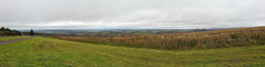


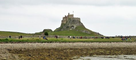


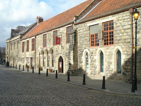
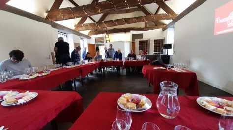
 Our tutor for the evening was
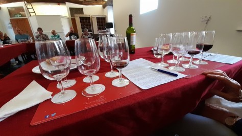


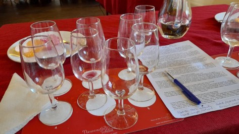
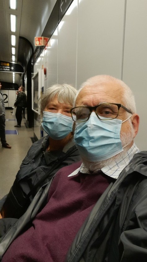


 My best friend Alan Brennan, a year younger than me, lived just a few doors further up Moody Street. But we didn’t go to the same school. I was enrolled at Mossley C of E village school, a couple of miles south of the town, like my two brothers and sister before me. Each weekday morning, my elder brother Edgar (just over two years older than me) and I took the bus together from the High Street to Mossley. Sometimes, in the summer, I’d walk home on my own (something that parents wouldn’t even contemplate today).


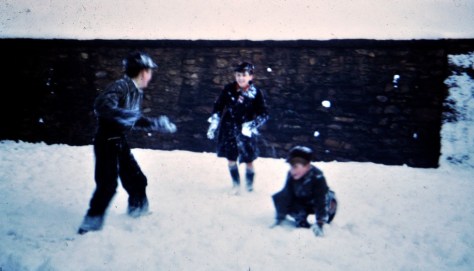


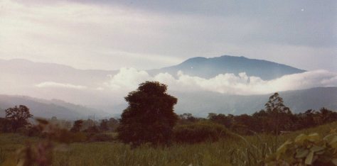


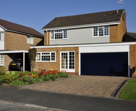
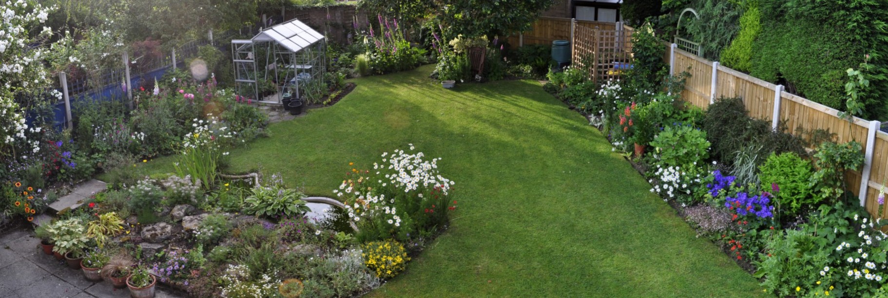


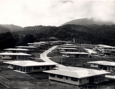


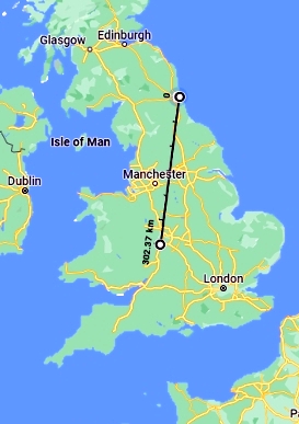 However, by the end of 2019 we had eventually decided to leave Bromsgrove and move north to Newcastle upon Tyne where our younger daughter Philippa and her family live. (Our elder daughter lives in Minnesota).
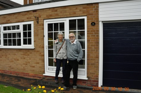


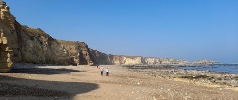


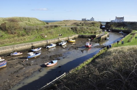


 Taking my trusty binoculars along (a pair of Swift Saratoga 8×40 that I’ve had for about 60 years) we hoped there might be some interesting wildlife to observe. On one of our previous visits, we’d come across a pair of roe deer among the pine trees. I was hopeful there might be some interesting birds along the River Derwent, the northern boundary of the Gibside estate.


 Another surprising visitor to the garden, just once, was an uncommon mistle thrush (right), a much larger cousin of the song thrush.


 On the coast we see the usual range of waders such as oystercatchers, ringed plovers, sanderling, dunlin, and turnstones. One of my favorites however is the redshank (right), easily spotted because of its bright orange-red bill and legs. And, of course, several species of gull.
_a_(3949776435).jpg under cc-by-sa-2.0")


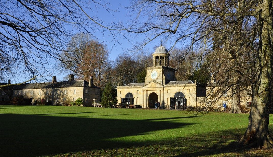


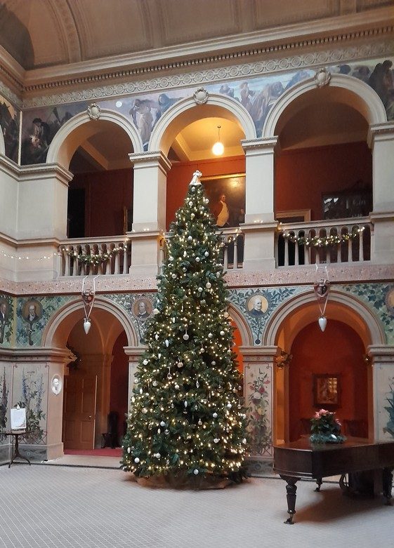


 Not any more. Just take a look at Google Maps


 Being a new build house, there were only a few things that needed my attention inside and they were quickly dealt with over a few weeks. Outside was a different prospect, and a project that has kept us busy—well, kept Steph busy— ever since: the creation of a new garden. Both the front and rear of the house only had lawns. So Steph came up with a design and we called in a small company at the end of April to remove the surplus turf. Then we set about planting all the materials we’d brought from Bromsgrove and carefully nurtured over the winter.

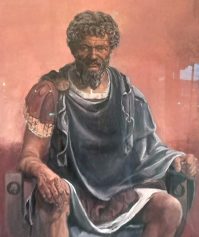
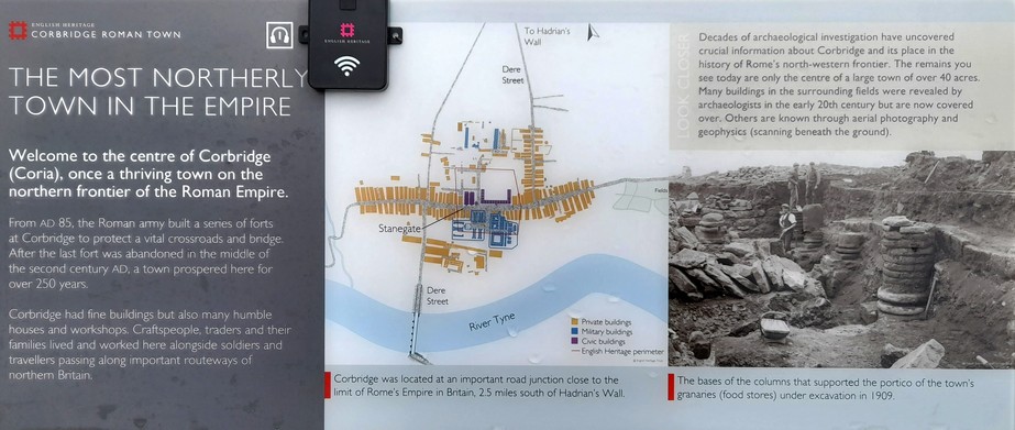
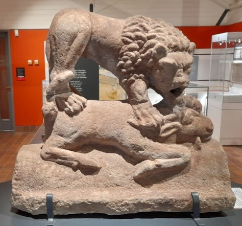


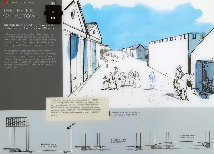


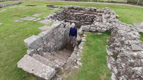
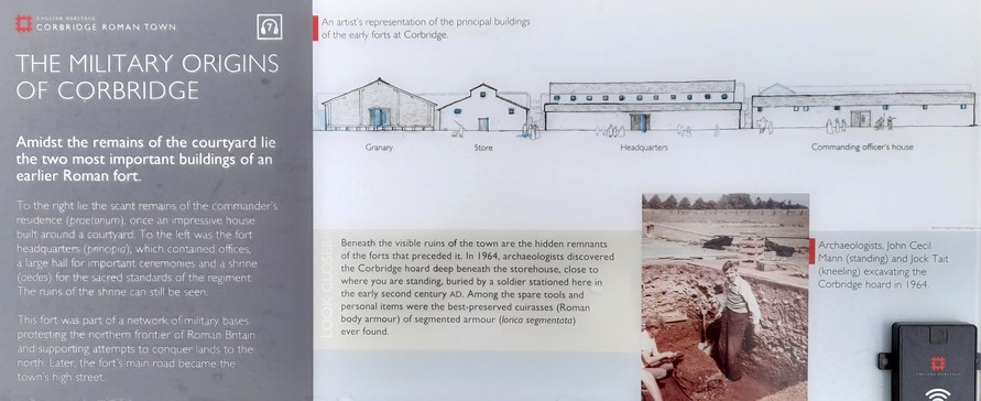
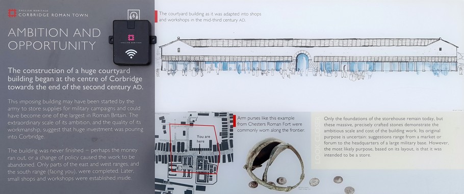
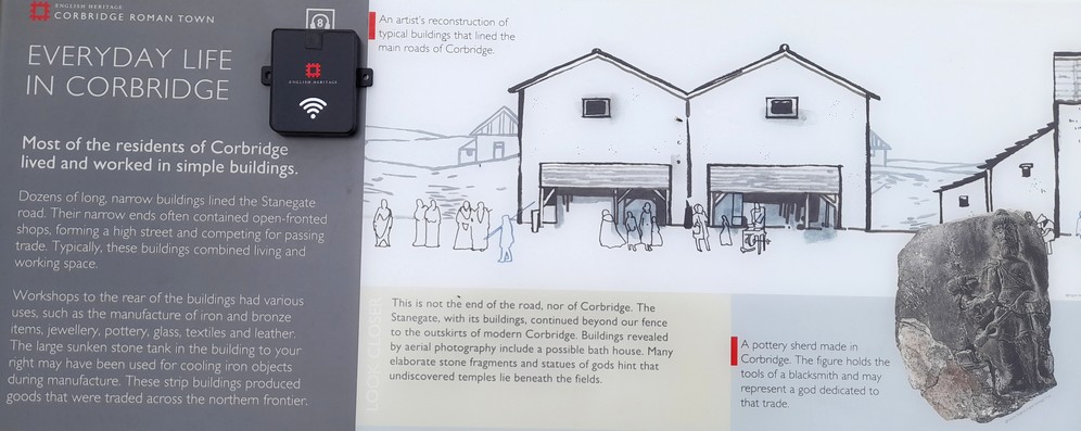
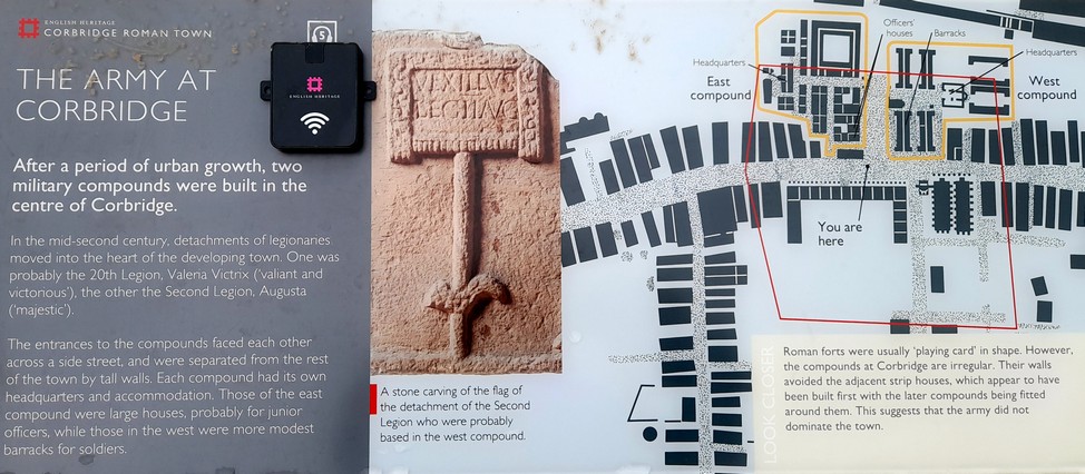
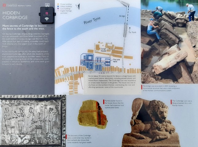
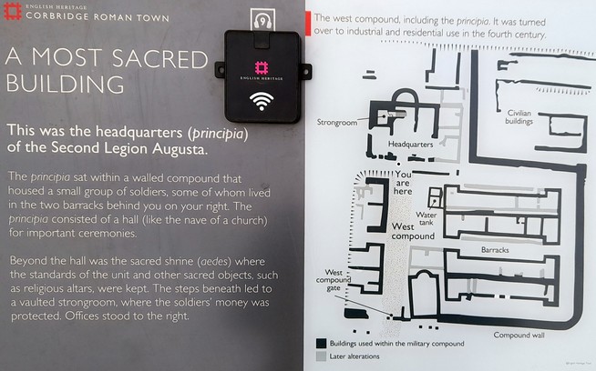
 One of Northumberland’s most famous sons was artist and naturalist
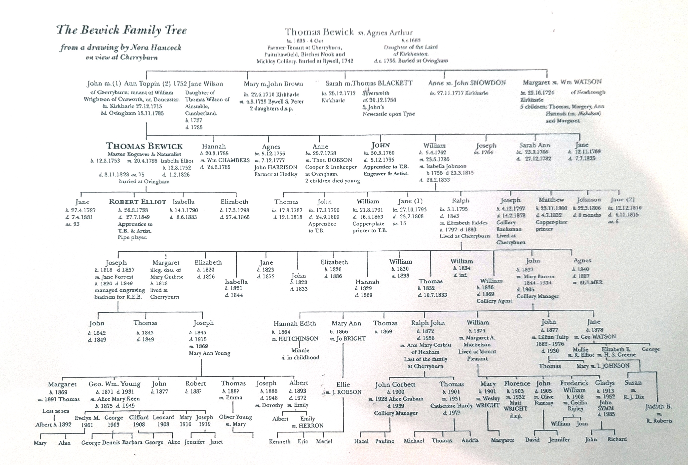


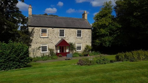


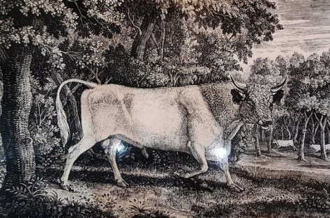
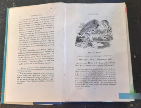
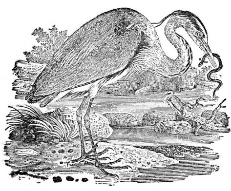


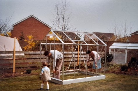

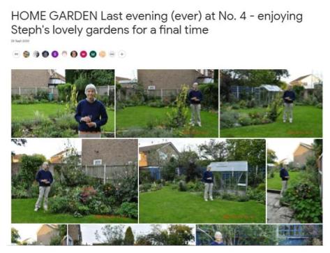


 Before leaving Bromsgrove, Steph had collected seeds from most of her favorite plants, or taken cuttings. So we brought them in half a dozen crates full of small pots, and carefully nurtured them through our first northeast winter.


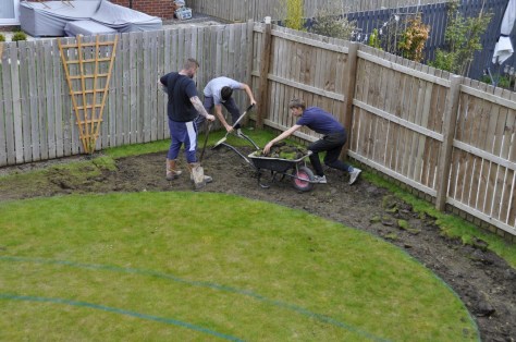


 Once the weather improved in May and June, and we could get out and about more regularly, Steph and I visited several abbeys and priories managed by English Heritage that dot the landscape of this northeast corner of England, including
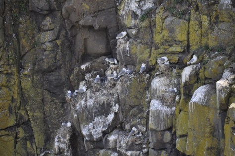


 About 7 miles northwest from Prudhoe, as the crow flies, the fortified manor house of
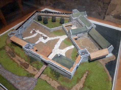
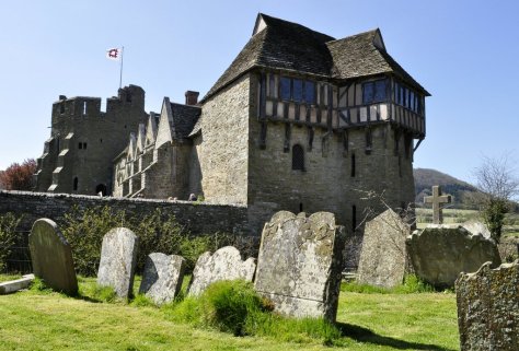


 We have visited 14th century


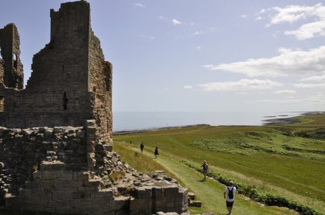
 For the past couple of months I’ve delved into Roman military fiction by British authors


 Much of our understanding of the history and archaeology of Hadrian’s Wall is down to one man in the nineteenth century:


 Chesters Roman Fort


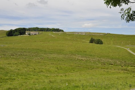

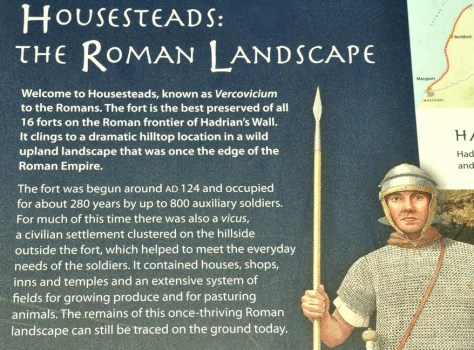 What is particularly impressive about Housesteads is its remote location. There are spectacular views from the fort over the surrounding Northumberland landscape, in all directions. And the fort and Hadrian’s Wall are intimately connected. It must have been an important site along the wall, in defence of the empire.
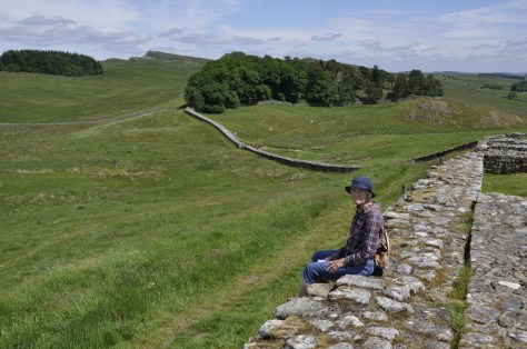
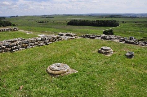


")


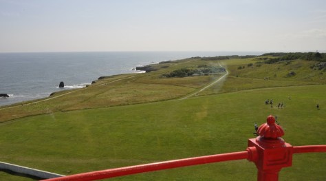


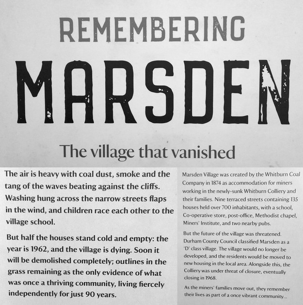
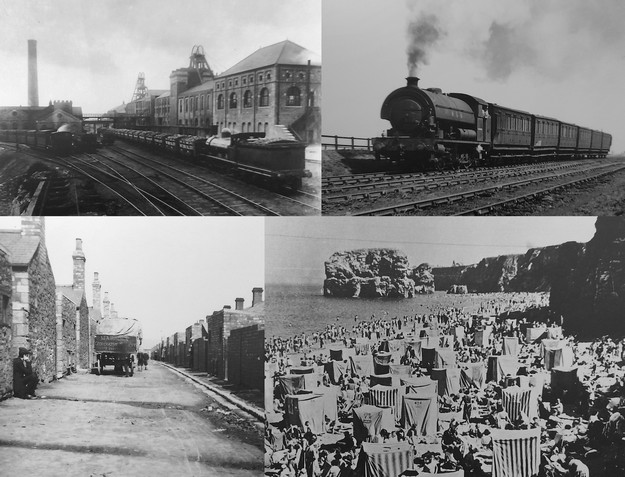
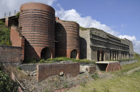

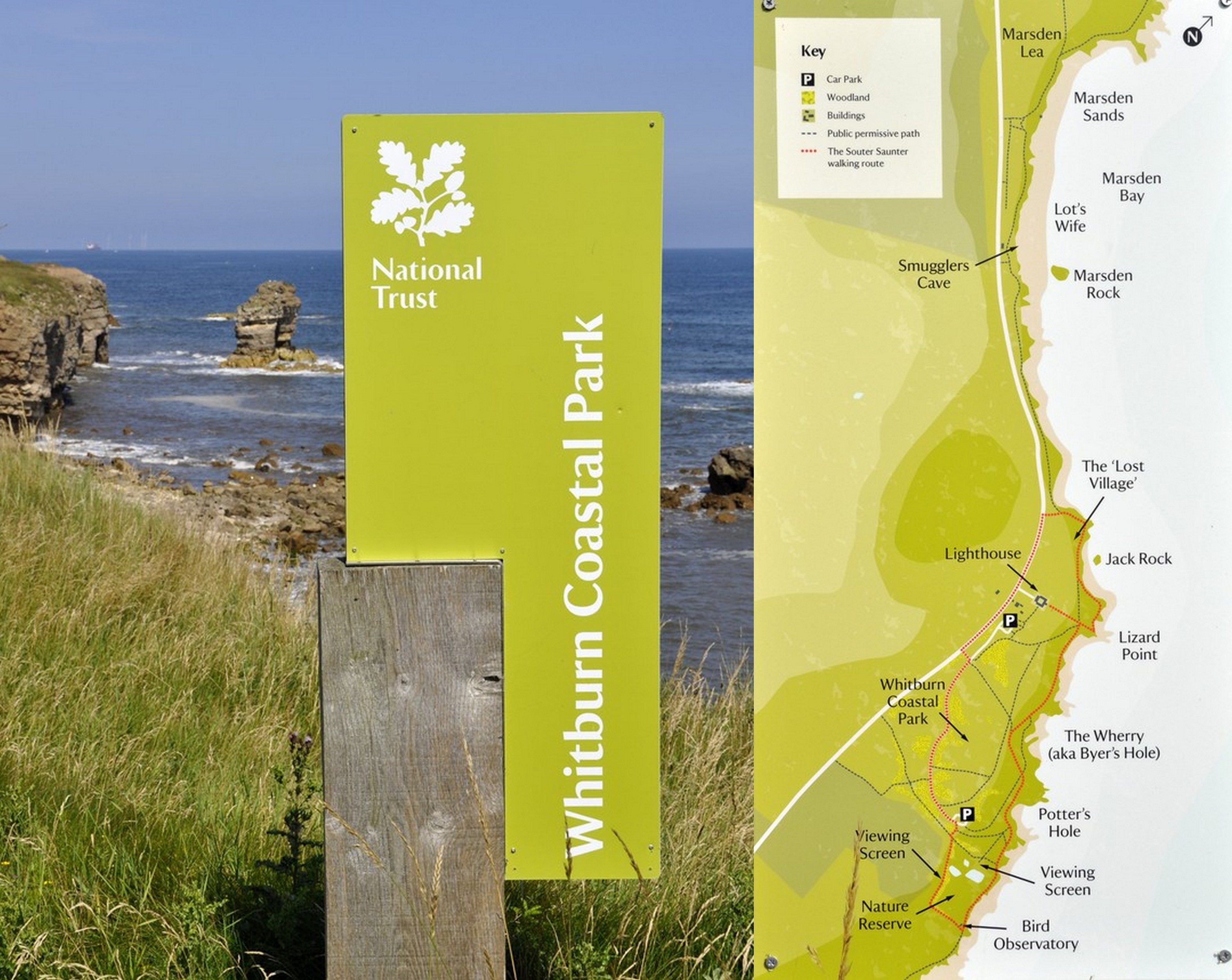


 The site is owned and managed by
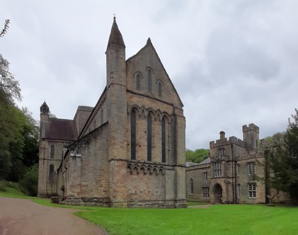
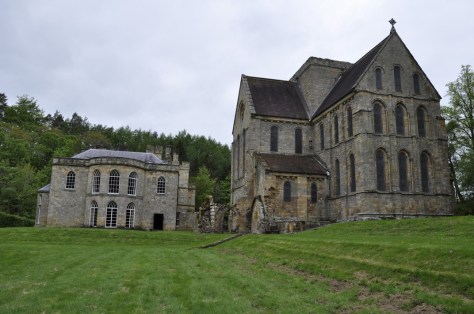


 As we sat on a bench, eating a picnic lunch and facing the west end of the priory church, I couldn’t help reflecting on the other ruined monasteries and the like that we have visited over the years:
  And a couple of days ago, after seven months here in the northeast of England (on the outskirts of Newcastle upon Tyne in North Tyneside), Steph and I took our first ride on the region’s Metro. Destination: Tynemouth, just six stations and 12 minutes from our nearest station, Northumberland Park.
 Earlier last week we upgraded our concessionary travel passes (CTP) to Gold Cards. With our CTP, we have unlimited free travel on buses nationwide, one of the benefits of being a senior citizen. For an extra £12 fee, we purchased unlimited travel on the Metro that we can use everyday, but only after 09:30 on weekdays. Here’s my CTP. Somehow my image was squashed; the original I submitted with my online application was fine.
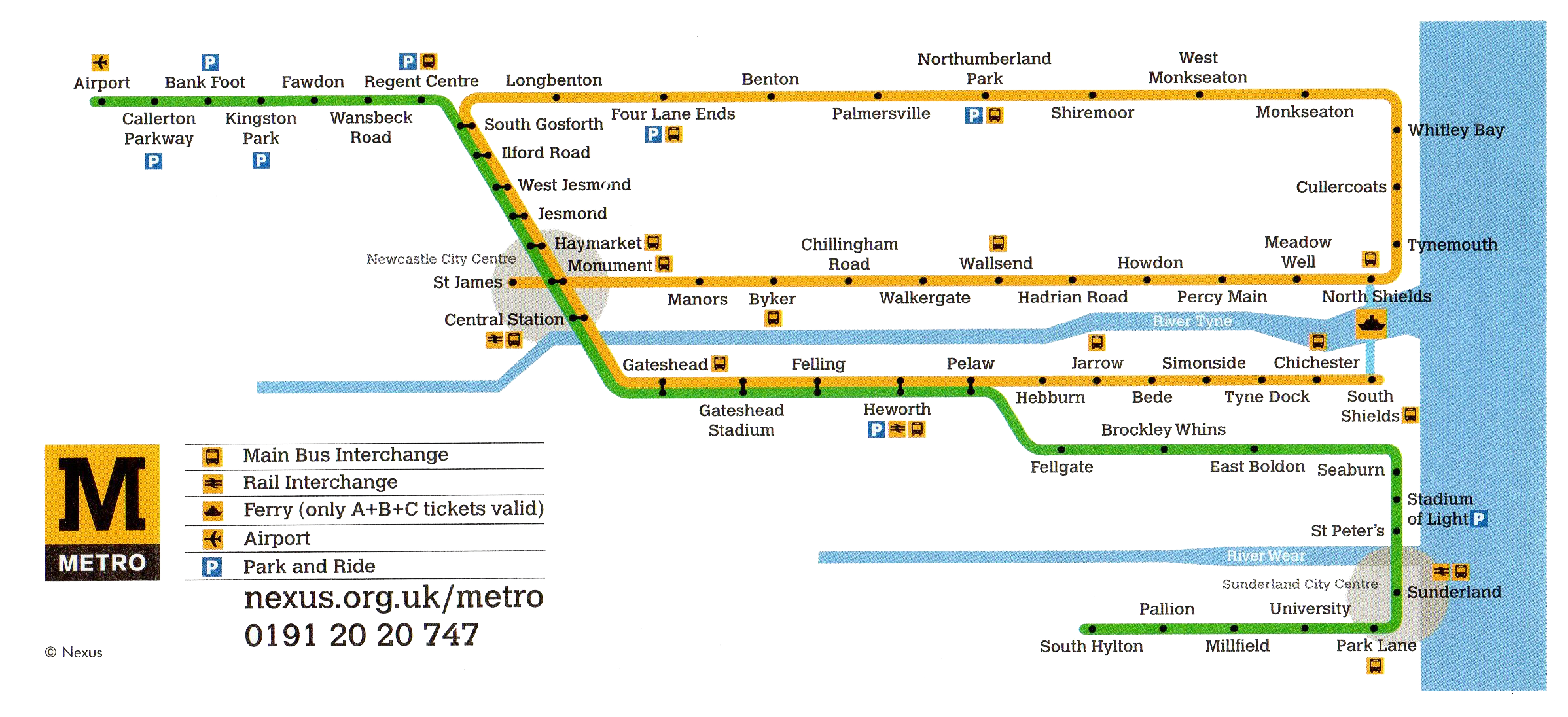


 This time, however, we had a particular Tynemouth destination in sight: