Hardly surprising, really. It was the middle of the day, and the sun was beating down the whole time we were there. The hottest day of the year to date, just earlier this week.
So where were we? In Whitby, on the North Yorkshire coast, about 75 miles south from our home in Newcastle (map). But we weren’t in search of Count Dracula and his cohorts. No, we were there to visit the impressive ruins of 13th century Whitby Abbeyon the headland jutting out into the North Sea, and overlooking Whitby town and harbor.
The view over Whitby from St Mary’s churchyard next to the abbey.
But what’s all this about vampires and Goths? Well, Irish author Bram Stoker used the ruins of Whitby Abbey as a backdrop to part of his narrative in Dracula (published in 1897). And the Dracula (and Goth) connection has been keenly adopted and celebrated in Whitby to this very day.
Humans have occupied the Whitby headland for millennia, with good archaeological evidence from pre-history, Roman, and Anglo-Saxon times.
It was in the mid-seventh century that a nun, St Hild, founded a monastery at Whitby, and it quickly became a seat of learning.
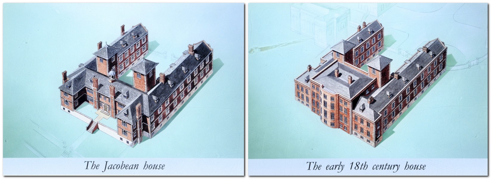
Nothing remains of the Anglo-Saxon monastery, nor of the stone building that replaced it from the 11th century. Just looking at the silhouette of the 13th century ruins against a deep blue sky it’s not hard to imagine how magnificent Whitby Abbey must have been in its Benedictine heyday. Until, that is, Henry VIII got his grubby regal hands on it in 1538 during the Dissolution of the Monasteries.
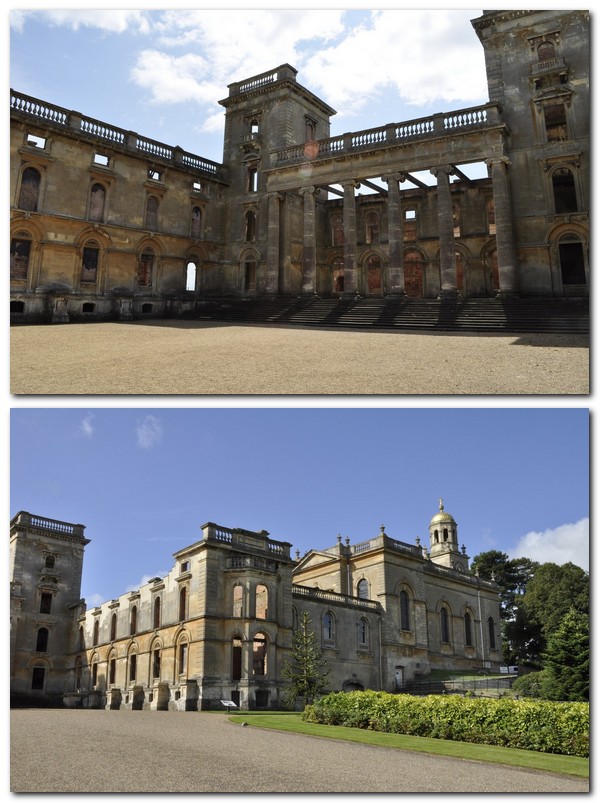
Thereafter, the abbey and its lands became the property of the Chomley family, who built a grand house beside the abbey ruins, presumably using stone scavenged from the ruins. The house standing today (built in the late 17th century) now houses a small museum and the English Heritage shop.
But let’s get back to the ruins.
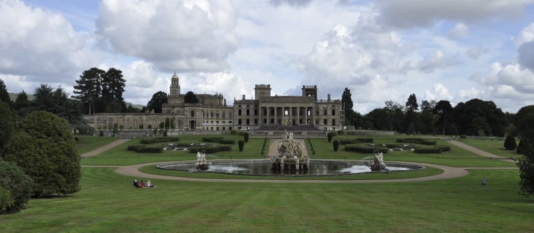
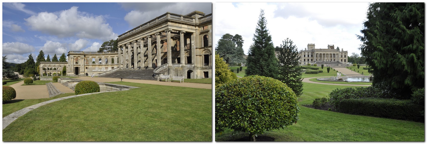
Similar in design to other monasteries in the region, such as Rievaulx and Fountains, Whitby Abbey was rebuilt in the 13th century in the Gothic style. There’s a brief description of the various architectural stages on the English Heritage website.
Because it stands proudly on a headland, and not surrounded by woodland or hills, it looks in some ways much more impressive than its larger counterparts. From a distance of several miles, as the road into Whitby from the west (the A171, Guisborough Rd) drops quite dramatically from the edge of the North York Moors to the coast, the monastery is a clearly visible landmark standing proudly above Whitby along the River Esk.
The abbey’s sandstone has weathered to a delicious light brown in some places. There’s certainly sufficient ruins remaining to appreciate how it must have appeared centuries ago. Although it has suffered the ravages of time. Even as recently as 1914, when it was shelled by the German Navy that was attacking a coastguard emplacement on the headland.
Here are just a few photos of the Abbey. I have posted a complete set of photos in this album.
We couldn’t have wished for better weather to see Whitby Abbey ruins in all their majesty. We visited Whitby just once before, in 1988, but not the Abbey. So, it had been a long-held aspiration to return one day. I have a feeling that it won’t be the last. But not in when the Whitby Goth Weekend is in full swing.
Brinkburn Priory, an early 12th century Augustinian ‘transitional’ priory (architecturally between Norman and Gothic), nestles in a deep bend of the River Coquet in central Northumberland. All that remains today is the priory church, which was restored in the 19th century with the completion of a new roof, and installation of beautiful stained glass windows.
The free car park is located about 400 m from the priory itself, but from experience I can say just how enjoyable that stroll was, high above the fast-flowing Coquet, the trees, shrubs and understorey plants coming into flower, and a multitude of birds singing all around, trying to out-compete one another.
Brinkburn was dissolved in 1536. It was considered a ‘Lesser Monastery’ with a value of only £69, so was spared the fate of most monasteries. The church continued to be used until the late 16th century when it fell into disrepair and the roof collapsed. A manor house was built alongside the priory church in the late 16th century, incorporating parts of the other monastery buildings that had been destroyed. This manor house was refurbished by the Cadogan family who also undertook the restoration of the priory church from 1858. It took just a year to replace the roof, and the windows were installed by 1864.
Just click on the image below to open the album of the photos I took during our visit yesterday.
Access to the manor house is limited to just the ground floor and basement, where the ancient stonework from the former priory buildings is exposed, and how the undercroft from the old monastery was used as a foundation for the house.
As we sat on a bench, eating a picnic lunch and facing the west end of the priory church, I couldn’t help reflecting on the other ruined monasteries and the like that we have visited over the years: Fountains Abbey, Rievaulx Abbey, Mount Grace Priory, Lilleshall Abbey, Wenlock Priory, White Ladies Priory, and Hailes Abbey. And they all have one thing in common. The monks knew how to choose just the right location to build their communities. Such peaceful places to think, take pause. The bench we sat on was dedicated to the memory of a couple who had visited Brinkburn frequently, simply because they found it such a peaceful place. I know how they felt, sitting there beside the church and the babbling River Coquet.
I love train journeys. Long or short. It makes no difference. I’d travel everywhere by train if it were possible, convenient, and affordable.
And a couple of days ago, after seven months here in the northeast of England (on the outskirts of Newcastle upon Tyne in North Tyneside), Steph and I took our first ride on the region’s Metro. Destination: Tynemouth, just six stations and 12 minutes from our nearest station, Northumberland Park.
We had delayed taking the Metro until Covid-19 travel restrictions had been eased, infection rates had started to decline steeply, and both of us had been vaccinated. It’s now been almost three weeks since we both received our second vaccine doses: Pfizer for me, AstraZeneca for Steph.
Earlier last week we upgraded our concessionary travel passes (CTP) to Gold Cards. With our CTP, we have unlimited free travel on buses nationwide, one of the benefits of being a senior citizen. For an extra £12 fee, we purchased unlimited travel on the Metro that we can use everyday, but only after 09:30 on weekdays. Here’s my CTP. Somehow my image was squashed; the original I submitted with my online application was fine.
The Tyne & Wear Metro (a publicly-owned transport system) serves five metropolitan boroughs: Newcastle upon Tyne and North Tyneside on the north bank of the River Tyne, and Gateshead, South Tyneside, and Sunderland, on the south side, which together make up the former Tyne & Wear metropolitan county. The first stretches of the network opened in 1980, and today comprises the Green and Yellow Lines. In all there are 60 stations along almost 50 miles of track.
Parts of the network utilize former 19th century railway lines, one of the oldest parts being the former Newcastle and North Shields Railway. In recent decades, new Metro lines have been added or extended, taking the network as far west as Newcastle Airport. The system has overhead electrification throughout. The rolling stock is, however, showing its age, and breakdowns are not infrequent. The Metro is currently undergoing a major upgrade and new rolling stock are expected to be introduced over the next couple of years.
Train to Tynemouth approaching Northumberland Park station.
Train departing Northumberland Park towards Shiremoor, the next station down the line, and on to Tynemouth, eventually leading back into Newcastle city center.
Several of the stations are the original ones built for the former rail companies. Monkseaton, Whitley Bay, and Tynemouth are particularly outstanding: beautiful red brick buildings, with glass roofs to the platform edges. Tynemouth is a striking example, and has lost none of its Victorian charm.
Northumberland Park is one of the newest stations, opened in 2005 to serve the recent housing developments nearby on reclaimed mining land, and the Cobalt Business Park just a mile or so to the south (largely vacant at the moment due to office closures during the pandemic).In this video, we are approaching Tynemouth station.
So, why did we head to Tynemouth as our first Metro destination? We’ve been there several times before when visiting Philippa and family over the years.
This time, however, we had a particular Tynemouth destination in sight: Tynemouth Priory and Castle, owned and operated by English Heritage.
This was a Benedictine priory, which the same fate as countless others under the Dissolution of the Monasteries during the reign of Henry VIII between 1539.
The priory (and its fortifications) were built on the headland of Pen Bal Crag, that juts out into the North Sea opposite the end of Tynemouth Front Street.
From the grounds of the priory and castle there are excellent views of St Edward’s Bay to Sharpness Point to the north, and overlooking Short Sands beach.
King Edward’s Bay from Tynemouth Priory.
To the south, the coast stretches past South Shields, overlooking the north and south piers of the entrance to the River Tyne.
The mouth of the River Tyne, with the Collingwood Monument on the right.
While we were having our picnic lunch overlooking the Tyne, a large transporter ship entered the river, making its way west upriver to dock of the port of Newcastle. This was once a very busy port, exporting coal worldwide. And it was a major ship-building location, sadly now disappeared. Although it was a bright sunny day with little breeze, I was surprised at how rough the sea was outside the north pier. As we approached the cliff edge we could hear the booming of the waves as they crashed against the pier. On the other hand, I guess I shouldn’t be too surprised. For the past few days we’ve had brisk northeasterly winds, with a long fetch down the North Sea from the Arctic.
Just inland from the mouth of the River Tyne, is a huge statue (facing south) of Vice Admiral Lord Cuthbert Collingwood (a Newcastle native) who was second-in-command to Lord Nelson at the Battle of Trafalgar in 1805.
Humans have occupied Pen Bal Crag for at least two millennia, with remains of Iron Age roundhouses discovered on the site. The earliest priory itself dates from the 7th century, but the ruins standing today date from the 13th century. There is a nice summary of Tynemouth Priory’s history on the English Heritage website.
Today the ruins are a stark reminder of how majestic Tyneside Priory must have been in its heyday. Standing on this peninsula, looking out to sea, the priory reminds me of Whitby Abbey (another site carefully managed by English Heritage on the North Yorkshire coast).
The entrance to the priory passes through the gatehouse of the castle, and opens up on to a broad grassy area, overlooking the coast, and encompassing the ruins, a cemetery of mainly 18th and 19th century graves, many incredibly weathered sandstone, and an abandoned coastguard station. There are also World War One and Two naval gun fortifications facing out to sea.
The entrance to Tynemouth Castle and Priory.
Tynemouth Priory.
A couple of things struck me as we walked around the ruins. Again, how the monks chose such inspiring locations to build their monasteries. And second, what a beautiful sandstone they used for Tynemouth Priory and its castle fortifications. It glowed a deep golden brown in the strong May sunshine.
After the Dissolution, the site was occupied for centuries by the military and, as I mentioned earlier, artillery installations from two world wars dominate the cliffs overlooking the entrance to the River Tyne.
There has also been one further addition—a bit of a blot on the landscape—especially as it has been abandoned for 20 years. In 1980, a new coastguard station was constructed alongside the priory ruins. Following a restructuring of the coastguard service in 2001, the station was closed and stands there today, a white elephant staring out to sea. Rather incongruous, given the serenity of the priory ruins close by.
Our visit to Tynemouth Priory was certainly one of our most convenient English Heritage or National Trust visits. Having enjoyed our picnic, we made our way back to the station for the short journey home. We’d walked almost four miles, and enjoyed the sea breezes. No wonder I felt tired after we arrived home. It didn’t take long before I dozed off in my armchair.
When I retired in 2010, I briefly toyed with the idea of enrolling at the Open University for a BA degree in history. That would have been quite a departure for me, since I already have graduate degrees in botany.
However, over the years working as an agricultural research scientist and academic, I developed a keen amateur interest in history, and was fortunate to visit many interesting historical and archaeological sites all over the world, such as the ruins of Tikal in Guatemala, Machu Picchu in Peru, and Angkor Wat in Cambodia, for example, or the Great Wall of China, that stand as silent and emblematic reminders of once powerful empires.
When you think about it, history is often the narrative of subjugation of one nation, society or culture by another. To the victors the spoils, who then make the rules, control the narrative.
Much of my recreational reading for the past 30 years consisted of biographies and histories. Not just UK history, but increasingly, accounts of the American Civil War in particular. During our road trip in the USA in 2019, I persuaded Steph to include several important Civil War sites in our itinerary.
I also quite enjoy historical novels, and over the past few months polished off the Wolf Hall trilogy by twice winner of the Booker Prize, Hilary Mantel.
So much so that I then borrowed A Place of Greater Safety from our local library, her 1992 account of the French Revolution seen through the eyes of three protagonists: Georges-Jacques Danton, Maximilien Robespierre, and Camille Desmoulins. That inspired me to find a history of that traumatic event. So I’ve now just opened the first pages of Stephen Clarke’s The French Revolution (first published in 2018) that I came across on the library website. I must look for Simon Schama’s 1989 Citizens.
When I was in high school in the 1960s neither of my two (maybe three) history teachers spawned any affection for their subject. Everything was taught by rote, with little contextual analysis of principals or events. In contrast, my two daughters Hannah and Philippa, who studied for their International Baccalaureate (IB) Diplomas at the International School Manila, thrived on history (even though both became psychologists). Hannah’s extended essay (an IB requirement, which she could have chosen from any of her six subjects) focused on the impact of the emerging railways on the canals in 19th century England. Philippa had a poor history experience for the first year of her IB course, which was rescued in the second when a new teacher, Mr Fischer, was appointed to take over a potentially failing class. He dragged them up by their historical bootstraps, so to speak, encouraging them to higher achievements. Philippa was awarded the highest grade 7, one of the few at that level worldwide for her particular modern European history course. How I wish I’d had an inspirational history teacher like that.
While I’ve more recently taken an interest in American history, I was initially drawn to 18th and early 19th century European history, essentially the period between the accession George I in 1714 and the end of the Napoleonic Wars at the Battle of Waterloo in 1815. This was the Age of Enlightenment and industrialization, the transition from rural to urban economies, with all the privations that growing urban populations had to endure. It was a time of great social change, but also polarization of politics, particularly as that age-old rivalry between Great Britain and France spilled over into so many different conflicts across Europe. It was also an age of colonial expansion (by many powers, not just Great Britain) and empire building. And the height of slavery.
Historical narratives do change, as new evidence comes to light and events reinterpreted. I never cease to be amazed at how much of the last 1,000 years of our history is carefully preserved in the National Archives at Kew in London, where primary documents are available for historical research. I also discovered that the UK Parliament still prints its laws (for archival purposes) on long-lasting vellum made from calf- or goat-skin. The oldest extant law available on vellum dates back to 1497.
But apart from dates and places, people and events, history is also about relationships, of motives, of actions taken and their consequences. That’s why narratives do meander over the years, depending on the interests and perspectives of each historian, and whether they have a particular historical (or even political) axe to grind.
Today, however, historians (and society in general) face another challenge: how to view the past through a 21st century prism, as well as in terms of today’s mores.
The 2020 Black Lives Matter (BLM) anti-racism campaign has forced us all to confront the uncomfortable truth that the twin abominations of racism and slavery are very much part of our nation’s narrative. As are the consequences of colonial expansion and empire and that, all-too-frequently, atrocities were perpetrated in the name of King/Queen and Country. Abominations that must be acknowledged, not set aside or brushed under the carpet as irrelevant to society today.
Since I was born in the first half (just) of the 20th century, in 1948 actually, can I be held responsible for what past generations perpetrated? Not directly, of course. We can’t turn back the clock, but my generation can finally face up to issues that, until now, were too uncomfortable to accept or talk about openly.
One particular highlight of the BLM campaign here in the UK last year was the toppling of the statue of Bristol merchant and philanthropist, Sir Edward Colston (1636-1721), that ended up in Bristol harbour.
The statue was erected in 1895, but in recent years Bristolians had begun to question why the city continued to give prominency to someone whose fortune was derived from his involvement in the slave trade. At least one civic building and street had also been named after him.
But was giving Colston’s statue the heave-ho an acceptable way to address this issue? Can we expunge Colston and his like from history? Clearly the answer is ‘No’. A few days after his downfall, the statue was retrieved from the depths of the harbour, and after undergoing repair and cleaning, it will be displayed in a local museum in a way that contextualises Colston and the age in which he lived. We need explanation and understanding, not destruction.
The same goes for other statues, such as that of imperialist (and racist) Cecil Rhodes on the facade of Oriel College at Oxford University. Oxford is not the only place where Rhodes has faced this ignominy.
Some protestors have demanded the removal of the statue of Sir Winston Churchill from Parliament Square in London, because of his racist and imperialist views. Churchill was not alone among his generation in being racist. But he is celebrated today for his leadership as the nation faced an overwhelming threat from Nazi Germany during the Second World War. The question we need to ask is whether his racism should trump his war leadership record? We need, I believe, a nuanced appraisal and understanding of this statesman (and others as well). We can and should condemn unacceptable (to us) beliefs and actions, but they also have to be understood in their contemporaneous context.
Steph and I are keen members of the National Trust, and if you check out the National Trust and English Heritage page on this blog, you will find accounts of the many glorious country houses that we have visited over the past decade.
In the wake of BLM campaign, some are accusing the National Trust of being overly woke. On a recent visit to Cragside in Northumberland, there was this message at the foot of the main staircase relating to a statue higher up:
I came across this article by historian David Olusoga in The Guardian yesterday, a commentary on those who are attacking ‘woke’ history.
The National Trust has a big task ahead. You only have to visit properties like Powis Castle where there is an impressive collection of Indian artefacts once belonging to Robert Clive, one of the founders of the British Empire in India. Or Kedleston Hall near Derby, where some of the treasures on display date from the period when George Nathaniel, Lord Curzon was Viceroy of India.
The treasures in these houses (and many others in the National Trust portfolio) were assembled over decades if not centuries through colonial settlement and/or slavery. Now the National Trust is beginning to better explain the background to the accumulation of such wealth. But it’s not just colonialism and slavery. For many land owners their wealth was created much closer to home, through merciless exploitation of the labouring classes, almost as a form of slavery in itself.
Confronting the past will be a challenge for the National Trust, and society as a whole. Then there are the ‘spoils’ of empire building locked up in museums all over Europe. The debate continues whether museums should repatriate artefacts that were acquired (= stolen in many instances) during the Age of Empire.
At least one museum, the Great North Museum: Hancock in Newcastle upon Tyne has revealed plans to ‘decolonize’ its collections, because . . . a number of our objects are inextricably linked with Britain’s colonial past and systemic racism . . . acquired over 250 years.
As the museum’s Keeper of Archaeology stated: Decolonisation, for us, is not an attempt to completely rewrite history, but rather an effort to shed light on areas of our past that have been neglected, or simply ignored.
I’m sure other museums will follow. Hopefully this will, in a small way, help counter the British exceptionalism narrative that has emerged during the Brexit debate, that has, in my opinion, also revealed just how deep-seated racism is in our society today. Not overt racism perhaps, but pervasive all the same.
As regular readers of my blog will know, my wife Steph and I are enthusiastic members of the National Trust (and English Heritage). At every opportunity, weather and other commitments permitting, we take off for an outing to one property or another. We are fortunate that there are so many within 50 miles of our home in Bromsgrove in northeast Worcestershire (just south of the UK’s second city, Birmingham). In recent years we have also taken short breaks to explore properties much further afield in Northern Ireland (in 2017), Cornwall (in 2018), and East Sussex and Kent and Lincolnshire (in 2019).
The Covid-19 pandemic and lockdown put paid to these lovely outings. Until yesterday! Our last outing before lockdown was in the middle of January when, on a very misty, moisty morning, we had an excellent walk around our ‘local’ property, Hanbury Hall, an elegant ‘William and Mary’ house in the Worcestershire countryside, just over six miles from home.
We have visited more than twenty times since we joined the National Trust in 2011. In fact, Hanbury Hall was the first property we visited after we became members.
We just enjoy walking around the park and the magnificent parterre that is, in my opinion, one of the best among all the Trust’s properties. We’ve been inside the hall itself only three times, and two of those occasions were to see the Christmas decorations.
Here are some images of the parterre taken over the years and in different seasons. While not as colorful as some of the parterres we’ve seen, like those at Waddesdon Manor, Charlecote Park, or Witley Court (an English Heritage property), I really do appreciate the elegant simplicity of the Hanbury version, with beautiful clipped box hedges and cones, holly shrubs, and sparse planting.
During lockdown, I have been able to get out locally almost every day for a 2-3 mile walk. But the same routes have become rather stale after all these weeks. So, after three months of lockdown, it was great to be able to get timed entry tickets to Hanbury Hall yesterday. This is only the second week that Hanbury (and many other National Trust properties) have re-opened, but not fully. Visitors are being limited currently to allow for sufficient social distancing. On arrival we were made welcome in a safe manner.
What a joy! We’ve been ‘starved’ of the opportunity of just deciding, on a whim, to put on our walking shoes and head off for a stroll of just under three miles around Hanbury’s park and garden.
Here is a link to the album of photos from yesterday’s visit.
I mentioned that Hanbury will no longer be our local National Trust property. That’s because we have sold our house (subject to contract) and expect to move to Newcastle upon Tyne in the northeast of England by the beginning of September. Well, that’s the plan and we hope there are no glitches and hitches along the house selling pathway.
We already know several of the National Trust and English Heritage sites across the north east, and a little further south. We look forward to exploring those once again, and seeking out many that are still on our bucket list. Exciting times!
It wasn’t until AD 43 that the Roman conquest of Britain under the Emperor Claudius began in earnest and was, to all intents and purposes, completed over the next 50 years. However, Roman rule lasted only 400 years or so. Then the Romans just upped and left.
Julius Caesar
Emperor Claudius
But what a profound impact Roman occupation had on the British landscape during those four centuries.
Take the road system, for instance. The Romans built 8000 miles of roads that enabled them to move armies and commerce across the country more easily. Roman roads are still exposed in many places, like the Wheeldale Roman road on the North York Moors that we visited in the summer of 1988 when Hannah and Philippa were ten and six, respectively.
However, take a look at today’s road system in the UK, and many of the most important trunk roads still follow the routes of Roman roads built 2000 years ago, such as the Fosse Way, Watling Street, and Ermine Street.
And at the same time that the conquest of Britain was underway on the far-flung northwest frontier of the Roman empire, just over 1000 miles southeast in Rome itself, the Colosseum was being built (by the Emperor Vespasian).
Aerial view of the Colosseum, with the Forum on the top right, and the Palatine Hill beyond on the top left.
The Romans founded cities all over England. There are so many fine examples of Roman settlements and architecture to be explored. Just take four examples that we have visited: the city of Wroxeter (Viroconium) near Shrewsbury, the villa at Chedworth in Gloucestershire, the lighthouse in Dover, standing high above the chalk cliffs on the south coast, or the landing stage at The Weir along the River Wye in Herefordshire.
Chedworth
Mosaics at Chedworth
Detail from the floor of the dining room at Chedworth
Looking west towards the west wing and the new display center, with the dining room on the left and the plunge pools on the right
Gate at Wroxeter
Wroxeter Roman city, Shropshire, south of Shrewsbury
Wroxeter
Wroxeter
Pharos at Dover
Pharos at Dover
Pharos at Dover
Inside the pharos
Roman archaeology along the River Wye
Along the River Wye
It’s also remarkable just how far north the Romans expanded their control. In order to protect their domain, a 73 mile long wall was constructed across the north of England, just south of what is today the border with Scotland, from the west coast on the Solway Firth to Newcastle (Wallsend) on the east. This is, of course, Hadrian’s Wall, whose construction began around 122 AD under the Emperor Hadrian.
Emperor Hadrian
Location of Hadrian’s Wall and the Antonine Wall
Hadrian’s Wall facing east towards Crag Lough. The rocky outcrop is the Whin Sill, of volcanic origin.
Sections of Hadrian’s Wall still remain, particularly in its hilly central sector. Little remains in lowland regions, where the Wall was previously plundered as a source of free stone for new buildings.
This fortification remained the Romans’ principal fortification against hostile tribes to the north. Here’s a short video from the Smithsonian Channel.
What I believe is less well known is that the Romans built another wall, the Antonine Wall some 100 miles further north, spanning a length of about 40 miles between the Firth of Clyde on the west coast and the Firth of Forth on the east, twenty years after construction began on Hadrian’s Wall. Unlike its counterpart to the south, the Antonine Wall was abandoned just a few years after it completion, and the Romans retreated south behind Hadrian’s Wall.
In 1998, when Steph and I spent a week touring Northumberland, we took the opportunity of exploring different sections of the Wall, near Cawfield Quarry, and at Housesteads Fort (Vercovicium; map) one of the largest settlements along the Wall. We’ve been back a couple of times since, but if I did take many more photos, I can’t lay my hands on them. That will be a project in progress once we move north.
Housesteads from the air (Source: English Heritage)
Just two miles southwest from Housesteads Fort is one of the most important Roman sites in the north of England, perhaps in the whole country: Vindolanda. It is owned and managed by The Vindolanda Trust.
Vindolanda is known for the huge quantity of Roman artefacts that have been recovered during archaeological excavations, many of which are on display in the excellent museum there. Of particular renown are the Vindolanda tablets, handwritten documents on wood detailing life on this lonely frontier of the Empire, and beautifully preserved for almost 2000 years.
Tablet 343: Letter from Octavius to Candidus concerning supplies of wheat, hides and sinews.
The tablet that is perhaps most cited, No. 291 from around 100 AD, was an invitation to a birthday party from the wife of the commander of a nearby fort.
North of Hadrian’s Wall, we also explored the site of a Roman encampment at Chew Green, overlooking the border with Scotland.
There’s not to much to see, just some raised mounds marking various buildings and the like. It’s a bleak spot, to say the least.
But there is (or at least should be) another legacy of the Roman occupation here and elsewhere. It’s not a legacy that you can observe as such. It needs the techniques of molecular genetics to reveal it. DNA!
We know, from writings left behind, that Roman soldiers from all corners of the Empire served on this northwest frontier. From as far east as Iran and Afghanistan, North Africa, and other regions of Europe. Unquestionably many will have had relationships (consenting or otherwise) with local women, and had children.
Britain is a nation built on immigration over millennia. The Roman conquest was the first major invasion of many that followed—the Germanic invasions, the Vikings, and the Normans. All left their DNA behind in the genetic melting pot. It’s just that the ‘Romans’ were the first, so to speak.
And we’re so hung up over immigration today. Ironic.
Belsay Hall, some 14 miles northwest from Newcastle upon Tyne, is a country mansion, constructed between 1810 and 1817 in the so-called Greek Revival style. It is believed to be the first house in the country to be built along these lines.
Steph and I visited Belsay Hall in late July 2009, along with our younger daughter Philippa and Andi (who she married in 2010).
The east front and main entrance
Its owner was Sir Charles Monck who, until taking up residence in his new house, occupied the 14th century castle on the Belsay estate nearby, and which is also open to the public.
Belsay Hall is a square building, and today is completely empty inside, being left in what has been described as ‘benign decay’. The only maintenance prevents the building from deteriorating further. The house is decorated throughout in the ‘Greek style’, pillars everywhere.
The stables and coach house, which are sited just to the northeast of the main entrance, are also open to the public.
On the south side of the house, there is a terrace and formal gardens.
After exploring the house, we made our way to the castle, a half mile walk through the Quarry Garden, a cool, dark, and damp environment favored by luxuriant ferns. The house was built from stone quarried here.
There is access to the roof of the tower and, on a nice day, I’m sure there must be fine views over the surrounding landscape. It was rather grey and misty on the day we visited.
In July 2009, there was a very special art installation mounted in the Great Hall.
Lucky Spot, as it is known, is a three dimensional chandelier in the shape of a leaping Appaloosa horse, hanging from the rafters of the Great Hall. Made from 8000 large crystals beads, it was a collaboration between Stella McCartney (daughter of former Beatle, Sir Paul McCartney) and the Austrian glass maker Swarovski. I’ve read that Stella McCartney was inspired to create Lucky Spot after a visit to Belsay.
Catching the light from all directions, this is one of the more impressive pieces of art that I have come across.
Once we move up to the northeast, a return visit to Belsay is definitely on the cards. This time I’ll make sure to use my camera rather more liberally than I did in 2009.
In the summer of 1998, when Steph and I were back in the UK on our annual home leave (I was working in the Philippines at the time), we had a week’s holiday in Northumberland. We spent almost the whole week within the boundaries of the county, the fifth largest in England, crossing into southern Scotland for just one night. It was the first time we had visited the county. But it wouldn’t be the last, not by a long chalk.
Our younger daughter Philippa enrolled at Durham University (under 20 miles south of Newcastle upon Tyne) in 2000, and after graduation in 2003, remained in the northeast, marrying Andi in 2010 and now raising two boys, Elvis and Felix. So, we’ve been traveling up to Newcastle at least a couple of times a year, and taking more opportunities to explore the fabulous Northumbrian countryside.
Northumberland has so much to offer, from moorlands to coast. There are so many Roman ruins to explore like Vindolanda and Hadrian’s Wall as well as magnificent castles like Bamburgh, Warkworth, and Dunstanburgh. The coast has some of the best beaches in the whole of the country, but not so good for bathing, at least in my opinion. Why? Because the North Sea is too damned cold!
The Farne Islands The Farnes (owned by the National Trust) are an archipelago of some 15-20 islands (depending on the tides) up to 4 miles off the northern coast of Northumberland, just south of the border with Scotland. They are one of the country’s most important sites for breeding seabirds, with significant colonies of puffins, terns, guillemots, and kittiwakes, among others. After a short (maybe 30 minutes) boat ride from Seahouses, we arrived at Inner Farne, the only island with access. It was a smooth crossing to Inner Farne in bright sunshine, but by the time of our arrival there, it had clouded over.
Puffins on the cliff edge, with guillemots on the far right.
Guillemots
Puffins, with guillemots closer to the cliff edge
Kittiwakes
Arctic tern
Shag
Arctic tern on its nest
Puffins
Arctic tern chicks
Shag on its nest
Puffins
As we approached Inner Farne, it was hard not to wonder at the sheer number of seabirds flying to and from the islands, as well as the rising cacophony of calls from the different species.
After landing, and as we made our way on the short walk to St Cuthbert’s Chapel, and afterwards as we explored other open paths, we were dive-bombed by protective Arctic terns that were nesting in the grass on all sides. And I can assure you that a passing peck from the tern’s dagger-like beak hurts! In fact, the National Trust encourages all visitors to bring suitable headgear for protection.
This was my first up-close experience of large colonies of seabirds. And what a feast for the eyes as you can see from the images above.
Besides the various bird (and grey seal) colonies, Inner Farne also has a long history of human occupation dating back to the late seventh century AD, becoming first the solitary home of St Aidan, and then St Cuthbert (who is buried in Durham Cathedral). Apart from National Trust reserve wardens stationed on the islands during the seabird summer breeding season, the islands are now uninhabited.
But they do have a particular claim to fame for the brave exploits of Grace Darling, daughter of the Longstone lighthouse keeper on another of the islands who, with her father, saved nine persons on board the paddle steamer Forfarshire that was wrecked in a tremendous storm on the Farnes in 1838. She was only 22. She died of tuberculosis in 1842, a national heroine.
Grace Darling (1815-1842) and the SS Forfarshire that foundered on the Farne Islands in 1838.
Holy Island and Lindisfarne Priory A little further up the coast is Holy Island, the site of Lindisfarne Priory (owned by English Heritage).
Access to the island is across a one mile tidal causeway that is submerged twice a day at high tide, so careful planning is required to safely cross on to the island, and avoid being stranded before the tide covers the causeway. I don’t remember exactly when we crossed, but we had no issues, and had plenty of time on the island itself before returning to the mainland. We did see a couple of cars that hadn’t made it in time, caught in a rising tide and abandoned by their owners.
We did not visit the castle on Holy Island. That is owned by the National Trust. I’m not sure if it was open to the public back in the day.
Monks first settled on Holy Island in AD 635, but after a violent Viking raid in AD 793 they fled from the island. The ruins that comprise Lindisfarne Priory date from the 12th century. The most spectacular is the Rainbow Arch.
I must have taken more photos, but these are the few that I’ve been able to lay my hands on.
We’ve only scratched the surface of Holy Island. Once we have moved north, then we hope to have many opportunities of exploring this magical place again, including the castle next time.
Update (11 June 2022): I just published an account of a recent visit to Lindisfarne Priory and Lindisfarne Castle.
Warkworth Castle, built in the 12th century, stands on a narrow neck of land in a loop of the River Coquet in Northumberland, close to where the river flows into the North Sea at Amble.
View from the Keep along the River Coquet towards Amble and the North Sea.
The view north overlooking part of Warkworth.
Steph and I were visiting family in Newcastle in April 2018, and on a bright sunny day, enjoyed an excursion to Warkworth beach with our younger daughter Philippa and her husband Andi, and grandsons Elvis and Felix (then 6 and 4, respectively).
Phil and Andi went straight home after the walk and a picnic, but we decided to take the boys to Warkworth Castle close-by, which is owned by English Heritage. And we were in luck.
On the day of our visit (21 April) English Heritage was celebrating St George’s Day (actually 23 April) with displays of ‘armed combat between knights in shining armour’, and many other attractions.
Visitors enjoying combat between ‘knights in shining armour’.
Felix and Elvis (with Grandma behind) enjoying the armed combat.
View from the Keep towards the Gatehouse. The Lion Tower is on the right.
Carvings on the face of the Lion Tower.
The castle came into the Percy family (later the Dukes of Northumberland) in the mid-fourteenth century. It saw action in the Wars of the Roses in the late fifteenth century, and parts of the castle were demolished (or ‘slighted’) then. It suffered further damage in the late sixteenth century.
Today, many of the internal structures have disappeared, but the outer curtain wall stands more or less intact. The Keep can be explored. The Lion Tower (on the right in the image immediately above) has some impressive stone carvings above the archway.
It’s an excellent destination for adventurous grandchildren who have some excess energy to burn off. From their reaction at being allowed to explore the different buildings it was clear that Elvis and Felix enjoyed their visit – just as much as Grandma and Grandad.
English Heritage Warkworth Castle in April
The image of Warkworth Tower on its mound that’s covered in daffodils has become iconic, and often use in tourism brochures and the like for Northumberland. Here’s my take.
Dominating the horizon on the coast of Northumberland, and overlooking the cold North Sea, Dunstanburgh Castle was built during the fourteenth century reign of infamous King Edward II by the king’s cousin, Earl Thomas of Lancaster between 1313 and 1322.
Approaching Dunstanburgh Castle along the coastal path from Craster.
The castle can only be reached on foot, about 1.5 miles north from Craster. The castle is owned by the National Trust, but the site is operated by English Heritage.
View of the great gatehouse over the southern mere.
Overlooking cliffs on one side, the castle had excellent natural defences, and occupied the site of an Iron Age fort.
Thomas of Lancaster was executed in 1322, and it passed eventually passed into the hands of John of Gaunt, Duke of Lancaster. It changed hands between Lancastrian and Yorkist forces during the Wars of the Roses, and suffered damage from which it never fully recovered. By the sixteenth century it was in an advanced state of decay.
Today, just a few of the towers are standing, particularly the entrance Great Gate with its twin towers. Also the curtain wall that surrounds the castle connecting with the cliffs.
It’s possible to climb some of the towers from which there are magnificent views over the surrounding Northumberland countryside.
Great Gatehouse
Righthand tower of the Great Gatehouse
The Inner Bailey
Inside one the towers of the Great Gatehouse
View over the coast, southeast from the Great Gatehouse
The view towards Craster from the Great Gatehouse
The Great Gatehouse from the Inner Bailey
The Constable’s Tower
The Great Gatehouse from near the Constable’s Tower
Queen Margaret’s Cove – with lots of kittiwakes
The Great Gatehouse from near Constable’s House
The Great Gatehouse from near Egyncleugh Tower
Looking towards Constable’s Tower and Egyncleugh Tower from the Great Gatehouse
The view towards Craster
Great Gatehouse ruins
Lichens thriving in the unpolluted air
View towards Craster
View north from the Great Gatehouse
Steph and I have visited the castle on a couple of occasions, the last being in May 2012. Parking in Craster, we enjoyed the coastal walk on a fine, bright but blustery day. The kittiwakes were nesting on the cliffs below the castle, and we spotted a weasel darting along a stone wall just above the tide line.
Then it was back to Craster for a pub lunch, and purchasing some of the renowned Craster kippers (smoked North Sea herrings).
Last week, Steph and I spent three days exploring five National Trust and English Heritage properties in Lincolnshire and Cambridgeshire. This is not an area with which we are familiar at all. We spent the first night on the coast at Skegness, and the second in the Georgian town of Wisbech.
It was a round trip of just under 360 miles from our home in Bromsgrove, taking in nine counties: Worcestershire, West Midlands, Warwickshire, Leicestershire, Nottinghamshire, Lincolnshire, Cambridgeshire, Norfolk (for about three minutes), and Rutland.
Our first stop was Tattershall Castle in Lincolnshire. There has been a fortified residence on this site since the mid thirteenth century, but it wasn’t until two centuries later that the remarkable brick tower was built. This is quite unusual for any castle, and Lord Cromwell is believed to have seen such buildings during his sojourns in France.
The tower and part of a stable block are all that remain today, although the position of other towers and a curtain wall can be seen. The whole is surrounded by a double moat.
Like so many other castles (see my blogs about Goodrich Castle in Gloucestershire, Corfe Castle in Dorset, and Kenilworth in Warwickshire) Tattershall was partially demolished (or slighted) during the Civil Wars between 1642 and 1651.
And over the subsequent centuries it slipped into decay. Until the 1920s when a remarkable man, Viscount Curzon of Kedleston (near Derby) bought Tattershall Castle with the aim of restoring it to some of its former glory, the magnificent tower that we see today.
The castle was then gifted to the National Trust in whose capable hands it has since been managed.
There is access to the roof (and the various chambers on the second and third floors) via a beautiful spiral stone staircase, quite wide by the normal standard of such staircases. But what makes this one so special is the carved handrail from single blocks of stone. And on some, among all the other centuries-old graffitti, are the signatures of some of the stonemasons.
Do take a look at this album of photos of Tattershall Castle.
Just a mile or so southeast of the castle is RAF Coningsby, very much in evidence because it’s a base for the RAF’s Typhoon aircraft, and a training station for Typhoon pilots. So the noise from these aircraft is more or less constant. However, RAF Coningsby is also the base for the Battle of Britain Memorial Flight, and just as we reached the car park on leaving Tattershall, we were treated to the sight of a Lancaster bomber (the iconic stalwart of the Second World War Bomber Command) passing overhead, having just taken off from the airfield, just like in the video below. At first, it was hidden behind some trees, but from the roar of its engines I knew it was something special. Then it came into view while banking away to the east.
Just 20 miles further east lies Gunby Hall, a William and Mary townhouse masquerading as a country house, and built in 1700. The architect is not known.
It was built by Sir William Massingberd (the Massingberds were an old Lincolnshire family) and was home to generations of Massingberds until the 1960s. You can read an interesting potted history of the family here.
Gunby Hall, and almost all its contents accumulated by the Massingberds over 250 years were gifted to the National Trust in 1944. Lady Diana Montgomery-Massingberd (daughter of campaigner Emily Langton Massingberd) was the last family member to reside at Gunby, and after her death in 1963, tenants moved in until 2012 when the National Trust took over full management of the house, gardens and estate.
Gunby is remarkable for two things. During the Second World War, the house was in great danger of being demolished by the Air Ministry because the runway at nearby (but now closed) RAF Spilsby had to be extended to accommodate the heavy bombers that would operate from there. But Sir Archibald Montgomery-Massingberd (husband of Lady Diana) was not a man without influence. He had risen to the rank of Field Marshal, and had served as Chief of the Imperial General Staff between 1933 and 1936. After he wrote to the king, George V, the location of the runway was changed, and Gunby saved.
It was then decided to gift the property and contents to the National Trust. So what we see in the house today is all original (nothing has been brought in from other properties or museums).
Sir Archibald Montgomery-Massingberd started life a simply Archibald Montgomery, but changed his name by deed poll to Montgomery-Massingberd on his marriage to Diana. It was a condition of the inheritance of the estate that the name Massingberd was perpetuated. Both he and Diana are buried in the nearby St Peter’s Church on the edge of the gardens.
Although not extensive, Steph and I thought that the gardens at Gunby were among the finest we have seen at any National Trust property. Yes, we visited in mid-summer when the gardens were at their finest perhaps, but the layout and attention to detail from the gardeners was outstanding. Overall the National Trust volunteers were knowledgeable and very friendly. All in all, it was a delightful visit.
On the second day, we headed west from our overnight stay in Skegness on the coast (not somewhere I really want to visit again), passing by the entrance to Gunby Hall, en route to Bolingbroke Castle, a ruined castle owned by English Heritage, and birthplace of King Henry IV in 1367, founder of the Lancaster Plantagenets.
There’s not really too much to see of the castle except the foundations of the various towers and curtain wall. Nevertheless, a visit to Bolingbroke Castle is fascinating because English Heritage has placed so many interesting information boards around the site explaining the various constructions, and providing artist impressions of what the castle must have looked like.
So the castle footprint is really quite extensive, surrounded by a moat (now just a swampy ditch) that you can walk around, inside and out, taking in just how the castle was built.
A local sandstone, rather soft and crumbly, was used and couldn’t have withstood a prolonged siege. Interspersed in the walls, now revealed by deep holes but still in situ elsewhere, are blocks of hard limestone that were perhaps used for ornamentation as well as giving the walls additional strength. The castle was slighted in the Civil Wars of the 1640s.
The complete set of Bolingbroke photos can be viewed here.
Heading south to Wisbech, our aim was Peckover House and Garden, occupied from the 1770s until the late 1940s by the Peckover family of Quakers and bankers.
Peckover House is a detached Georgian mansion, among a terrace of elegant houses on North Brink, the north bank of the tidal River Nene, and facing a counterpart terrace on South Brink, where social reformer Octavia Hill, one of the founders of the National Trust, was born in 1838.
Standing in front of Peckover House, it’s hard to believe that there is a two acre garden behind. Among the features there is a cats’ graveyard of many of the feline friends that have called Peckover home.
Inside the house, I was reminded (though on a much smaller scale) of Florence Court in Northern Ireland that we visited in 2017. The hall and stairs are a delicate duck-egg blue, and there and in many of the rooms there is exquisite plasterwork. Above the doorways downstairs are fine broken pediments.
The most celebrated of the family was Alexander (born in 1830) who traveled extensively and built an impressive collection of books and paintings. He was Lord Lieutenant of Cambridgeshire, and was elevated to a peerage in 1907.
He bought one of his books, a 12th century psalter, in about 1920 for £200 or so. Now on loan from Burnley library and displayed in Alexander’s library, the book has been insured for £1,200,000!
Our final stop, on the way home on the third day, was Woolsthorpe Manor, birthplace of Sir Isaac Newton, President of the Royal Society, who was born on Christmas Day in 1642 three months after his father, also named Isaac, had passed away.
This is the second home of a famous scientist we have visited in the past couple of months, the first being Down House in Kent, home of Charles Darwin. Woolsthorpe has become a pilgrimage destination for many renowned scientists, including Albert Einstein and Stephen Hawking who are shown in some of the exhibits.
Woolsthorpe is not a large property, comprising a limestone house and outbuildings. It has the most wonderful tiled roof.
It came into the Newton family as part of the dowry of Isaac Sr.’s marriage to Hannah Ayscough. Keeping sheep for wool production was the principal occupation of the family.
Isaac Newton won a place at Trinity College, Cambridge but had to escape back to Woolsthorpe during an outbreak of the plague in 1665 and 1666. He thrived and the 18 months he spent at Woolsthorpe were among his most productive.
Open to the public on the upper floor, Newton’s study-bedroom displays his work on light that he conducted there.
And from the window is a view over the orchard and the famous Flower of Kent apple tree that inspired his views on gravitation.
On the ground floor, in the parlour are two portraits of Newton, one of him in later life without his characteristic wig, and, high above the fireplace, his death mask.
Also there are early copies (in Latin and English) of his principal scientific work, the Principia Mathematica, first published in 1687.
And, with the 50th anniversary of Apollo 11 and the first landing on the Moon on 20 July 1969, there was a display of NASA exhibits and how Newton’s work all those centuries ago provided the mathematical basis for planning a journey into space. The National Trust has also opened an excellent interactive science display based on Newton’s work that would keep any child occupied for hours. I’m publishing this post on the anniversary of Apollo 11’s blast off from Cape Kennedy, now Cape Canaveral once again.
All in all, we enjoyed three excellent days visiting five properties. Despite the weather forecast before we set out, we only had a few minutes rain (when we arrived at Bolingbroke Castle). At each of the four National Trust properties the volunteer staff were so friendly and helpful, full of details that they were so willing to share. If you ever get a chance, do take a couple of days to visit these eastern England jewels.
~~~~~~~~~~~~~~~~~~~~~~~~~~~~~~~~~
* The Lincolnshire Wolds are a range of hills, comprised of chalk, limestone, and sandstone. The Fens are drained marshlands and a very important agricultural region.
On Senlac Hill (or Senlac Ridge), about six miles north of the coast in Sussex (map), a Saxon shield wall prepares to engage the Norman-French invaders under Duke William of Normandy. The Saxons, under King Harold Godwinson, have just arrived after marching south from Stamford Bridge in the East Riding of Yorkshire where, just three weeks earlier, they had defeated another invading force under King Harald Hardrada of Norway and his ally, Harold’s brother Tostig.
Exhausted and possibly out-numbered, this is a make or break stand for Harold’s Saxons. But, if they stand their ground, they are better positioned than the Normans who must cross a shallow valley then climb Senlac Hill to engage the Saxons.
This is the view from just below Senlac Hill looking south to where the Normans were mustered on the ridge in the distance. They had to cross this shallow valley to engage the Saxons.
For most of the day the battle (of Hastings as it has come to be known) ebbs and flows with neither side gaining an advantage. Until, late in the day, the Normans appear defeated and in retreat. The Saxons break rank and chase the fleeing Normans. But it’s all a feint. The Norman cavalry in small groups of five or six riders turn on the pursuing Saxons, and cut them down. Harold is killed (by an arrow through his eye, so the story goes), and William is victorious.
And so begin several centuries of foreign rule of England, first under the Normans and then under the durable Plantagenets who reign until the death of Richard III (the last Plantagenet king) in 1485 on Bosworth Field in Leicestershire.
Shortly after the Battle of Hastings, Duke William (now crowned King William I, the ‘Conqueror’) founded Battle Abbey, a Benedictine institution, although he died before it was completed.
The abbey endured until 1538 when, during the Dissolution of the Monasteries, under Henry VIII, the abbey was closed, the church demolished, and the lands sold off.
Today, Battle Abbey and the battlefield are owned by English Heritage, and there are many quite well-preserved ruins to explore. From the magnificent gatehouse there is an excellent view not only over the ruins and battlefield but also over the small town of Battle that grew up around the abbey.
The gatehouse (above) and the view over Battle (below)
Among the best preserved buildings is the Dormitory, and beneath it, the Common Room.
At the east end of where the Church once stood, the Crypt is now exposed revealing several chapels.
After the Dissolution, the Abbey passed through several families.
The independent Battle Abbey School now occupies part of the site of the former abbey.
For more photos of Battle Abbey and the battlefield, please take a look at this album.
Dover Castle sits high on the cliffs overlooking the town and modern port. The site has been fortified since at least the second century AD, when the Romans (who invaded in AD43) built a lighthouse (or pharos) there. But there is evidence of much earlier occupation back to Iron Age times.
From near Langdon Hole on the White Cliffs of Dover, looking west, this is the keep of Dover Castle on the right, and the Saxon church on the left.
The pharos still stands proudly beside a Saxon Church of St Mary in Castro (built around AD1000), and was once used as the bell tower.
A century after the Conquest, Henry II (great grandson of William the Conqueror) launched a major building program at Dover Castle. The keep was erected and much of what we see today began to take shape between 1179 and 1188.
Dover Castle has remained an important link in the chain of defences on England’s southern coast. During Tudor times, it was an important castle for Henry VIII. In the 18th century further garrisons were built to house soldiers sent there to face the threat of invasion from France. And it played an important role during the Napoleonic Wars that ended with Napoleon’s defeat and exile to St Helena in 1815.
Dover Castle
The castle also played its part during the Second World War. There are antiaircraft guns mounted on the battlements. And deep under the castle there is a series of tunnels used during the war. These are quite separate from the extensive medieval tunnels on the north side of the castle, which we had the opportunity to explore.
We must have spent four hours or more exploring Dover Castle. It’s an excellent destination for anyone interested in England’s post-Norman history. And also a mecca for families with children. English Heritage makes great efforts to bring history alive.
I mentioned that Dover Castle stands high above the town. Here are two short videos of the drive up to and down from the castle. They give a good impression of just how strategic its location is.
Just a couple of miles to the east are the White Cliffs of Dover. We walked only as far as Langdon Hole, but still managed a good view of the Cliffs and, once the haze had lifted, a view across the English Channel (La Manche) to the cliffs on the coast of northern France. Just twenty or so miles. It clear why Dover Castle was so important for the defence of the realm.
The White Cliffs of Dover are a National Trust property.
Bayham Old Abbey was founded around 1207 and, like the abbey at Battle, survived until the mid-16th century.
The ruins, some of the best preserved in southern England, stand proudly alongside the River Teise. We enjoyed them by ourselves in the late afternoon sun.
Once the Normans and their successors had their feet under the ‘English table’, so to speak, Saxon lands were confiscated and given to Norman families. Throughout southeast England, and more widely over the country, many of the estates we see today came from the spoils of conquest 1000 years ago.
During our exploration of National Trust and English Heritage properties in East Sussex and Kent, we took in three moated castles built in the 14th century.
Bodiam Castle was built around 1385 by Sir Edward Dalyngrigge, a knight formerly in the service of King Edward III (third great grandson of Henry II). It was occupied for almost three hundred years, until it was slighted (partially dismantled) during the Civil War of the 1640s.
Ask any child to draw a castle, and something resembling Bodiam is what they are likely to produce.
With towers at each corner, and imposing gatehouses, Bodiam Castle is surrounded by a deep moat full of large fish, probably carp. Unlike many castles, Bodiam does not have a central keep. The living apartments were built on the inside of the castle walls.
Owned by the National Trust, much of the castle is open to explore, and visitors can climb a couple of the towers, and enjoy the views over the moat and the central courtyard.
I have posted more photos and plans of the castle in this album.
There is a link between Bodiam Castle and the Second World War, and I now regret not taking a photo.
Alongside the path leading to the castle from the ticket office, there is a pillbox (a type of concrete blockhouse) that was constructed some time after September 1939 to help protect Bodiam bridge over the River Rother against a potential German invasion, although I’m not sure how this could have been successful in the face of a serious onslaught.
The moated manor house at Scotney Castle was built around 1380. It stands some distance from a large country house that was built between 1835 and 1843, known as Scotney ‘New Castle’.
You can just see the round tower of the ‘Old Castle’ in the valley below the terrace of the New Castle (L) and the ‘New Castle’ from the causeway on to the island of the ‘Old Castle’ (R).
The ‘Old Castle’ has not been occupied for a long time, and part of the castle has been completely demolished. Although begun in the late 14th century, the buildings date from different periods in the 16th and 17th centuries as well.
See the full set of photos here, including many photos of the interior of the ‘New’ castle. It’s a National Trust property.
Just east of Sevenoaks in Kent, Ightham Mote is one of the most delightful moated manor houses I have ever visited¹. It must be one of the most complete still standing. Over the centuries it has been owned by several families, each generation adding to its architecture (click on the image at right for a larger version), although the Selby family who purchased Ightham in 1591 resided there for almost 300 years.
But perhaps one of its most interesting periods dates from just over 60 years ago, when an American, Charles Henry Robinson (from Portland, Maine), purchased Ightham and lived there for some years. It passed to the National Trust when he died in 1985.
During our recent visit, we watched a short video about the conservation restoration of one of the wings of the house that the Trust commenced in 1989, and was finally completed 15 years and £10 million later. But how it was worth it!
Inside the house, the Great Hall, the New Chapel (with its ceiling panels painted to celebrate the marriage, in 1509, of King Henry VIII and his first wife, Catherine of Aragon), and the Drawing Room (with its exuberant fireplace and raised ceiling to accommodate it), decorated with 18th century hand-painted Chinese wallpaper, are of particular interest.
A visit to Ightham Mote is a stroll through 600 years of history, and the architectural and design interests of several families. What I particularly like about properties such as this are the small details that catch my eye, in the woodwork, the furniture, the wallpaper. The chapel ceiling immediately connects you with early Tudor times, for example, yet in other parts of the house, it’s clear that this was a home until just 35 years ago. Ightham Mote has a remarkable lineage.
Check out the full set of Ightham Mote photos and floor plans here.
¹ Little Moreton Hall in Cheshire (also a National Trust property) has to be the other. We visited there in 2013.
It is clear from our recent visit to Down House in Kent, the Georgian manor that Charles and Emma Darwin called home for 40 years until his death in 1882, that Darwin certainly did discover the value of life.
Charles Darwin, naturalist and confirmed agnostic, turned the world upside down in 1859 with the publication of his seminal On the Origin of Species, published to great claim, and controversy. It was written at Down House as was much of his prolific output.
Born in Shrewsbury in 1809, the son of a doctor and successful businessman, Robert Darwin, he had two illustrious grandfathers: natural philosopher Erasmus Darwin, and potter Josiah Wedgwood, both anti-slavery abolitionists and members of the Lunar Society of Birmingham. Darwin never knew his grandfathers, as both passed away before his birth.
Coming from a wealthy background and supported by his father and the Wedgwoods, Darwin had no need to find other employment. He could concentrate on developing his theories and publishing his ideas. He did not have to sell many of his precious specimens as was often the case for many naturalists like Darwin’s ‘rival’ Alfred Russel Wallace, for example, to keep body and soul together. Many items of Darwin memorabilia are on display at Down House today.
Darwin married his first cousin Emma Wedgwood in January 1839, and over the next seventeen years had ten children. Moving from a cramped house in London in September 1842, Down House was the ideal location for the Darwins to raise their growing family, and for Darwin himself to have the space and tranquility to develop his theories on evolution and natural selection.
When they moved to Down House, the Darwin’s were already the proud parents of a son, William (b. 1839) and a daughter Anne (b. 1841). Another daughter, Mary was born at the time of the move, but lived for less than a month. Their last child, Charles W. (b. 1856), died in infancy aged 18 months. Anne succumbed to tuberculosis in 1851.
Our visit to Down House was the first stop in a recent week-long break in the southeast. From home in northeast Worcestershire to Down House is a journey of 156 miles, under three hours by road, almost entirely on motorways (M42-M40-M25). Leaving the M25 at Junction 4, we took to the narrow lanes to cut across country to the Kent village of Downe.
Just four rooms are open to the public on the ground floor: Darwin’s Study (one can stand there in awe), the Dining Room (that Darwin, as a local Justice of the Peace, used as his court room), the Billiard Room, and the Parlour. No photography is permitted inside the house because all the items on display still belong to the Darwin family.
In the Dining Room there are two fine oil paintings of grandfather Erasmus. The porcelain on the dining table must surely be Wedgwood?
On the first floor (there’s no access to the upper floor) several rooms are filled with Darwin memorabilia, his journals, awards and the like. It’s a snapshot of Darwin’s life. One room was filled with wood engravings by Darwin’s granddaughter Gwen Raverat.
Another room, supposedly the Darwin’s bedroom, with a magnificent bow-window view over the garden, has been reconstructed by English Heritage, and photography is permitted there.
Down House has quite modest grounds, including an orchard. In the walled garden where Darwin conducted many of his experiments, the lean-to greenhouse has a small but fine collection of carnivorous plants and orchids.
At the far end of the garden, and parallel to the house and terrace, is the Sandwalk, a gravel path where Darwin (a creature of habit) would take a walk every day and work through all the ideas swirling around his mind. It’s not hard to imagine Darwin strolling along the Sandwalk.
As an evolutionary biologist who has worked on the variation in domesticated plants and in nature (addressed by Darwin in Chapters 1 and 2 of his On the Origin of Species) in potato and rice and their wild species relatives for much of my career, I had long been looking forward to this visit to Down House.
And I was both pleased and disappointed at the same time. It was incredible to see where Darwin had lived, and formulated one of the most important scientific theories ever, to see his journals and many other personal items, to learn something about his family and family life. Darwin often suffered from ill health, almost considered a hypochondriac. Now it’s thought that he may have been suffering from recurring bouts of Chagas disease that he picked up in South America during his voyage there on HMS Beagle.
On the other hand, I came away feeling that something had been missing. I didn’t feel much emotional connection to Down House as I have experienced in visits to other properties (such as Chartwell or Bateman’s, to mention just a couple). I know Darwin had lived in Down House. There was all the evidence in front of me. It just didn’t feel as though he had.
I mentioned that photography is not permitted inside Down House. Visitors are greeted at the entrance with a sign stating that photography is prohibited. Prohibited! Perhaps English Heritage could tone down the ‘request’. A more welcoming approach would be more appropriate.
Before visiting Down House, I decided to re-read On the Origin of Species, which I had first read many decades ago. I didn’t make good progress. It’s not that the subject matter is difficult. After all, Darwin’s ideas were ‘meat and potatoes’ to me during my working life. It’s just that Darwin’s style of writing is challenging, not helped by an extremely small font in the version I have. I’ll get there, eventually.
We live in the northeast of Worcestershire, shown in red, 180 miles from Robertsbridge.
. . . as well as corners of West Sussex and Buckinghamshire.
Steph and I have just returned from a week’s holiday in the southeast of England, a part of the country neither of us is familiar with, where we rented a one bedroom cottage near Robertsbridge in East Sussex (just 10 miles north of Hastings). This was our base for visits to National Trust (NT) and English Heritage (EH) properties. It lies at the heart of the High Weald Area of Outstanding Natural Beauty.
There are so many NT and EH properties to visit in the southeast, far too many for just one week. In the end we took in eighteen, including one on the trip south (to Down House, home of Charles Darwin in Kent), and Hughenden Manor north of High Wycombe in Buckinghamshire, the home of Victorian Prime Minister Benjamin Disraeli, on the return journey. And, during the week, we crossed briefly into West Sussex, to Standen House near East Grinstead.
Check out this map for more details, including links to the NT and EH web sites for each property. I’ll also be writing about our visits to these properties in several posts over the next week or so.
What a week! Great weather. Lots of history, and beautiful landscapes, from the chalk cliffs at Dover and the Seven Sisters at Birling Gap, to the heavily wooded High Weald.
The view southwest over the Weald from Emmetts Garden.
At Langdon Hole on the White Cliffs of Dover; and the Seven Sisters at Birling Gap.
Our holiday home, Hop Cottage, was situated at the end of a half mile unpaved road, set among trees alongside a couple of other cottages. We had the site to ourselves.
And what a feast of bird song to entertain us. I’ve not heard a song thrush (right) for a long time. But, each morning, we awoke to one singing his heart out, perched high in the early morning sun. I thought I’d try my luck recording his song on my smart phone. Just click here to listen to my short (2 minutes) recording. Not bad for a first attempt.
As an evolutionary biologist, I couldn’t resist calling at Down House on the way south, the house Charles and Emma Darwin called home for many decades, and where they raised their large family.
It’s where he wrote his seminal On the Origin of Species, published to acclaim—and controversy—in 1859. We had free range of the gardens, but photography was not permitted inside the house except for a reconstructed bedroom on the first floor. Most of the items on display downstairs still belong to the Darwin family.
The Sandwalk (at the far end of his garden), where Darwin walked daily and pondered his ideas about natural selection and evolution.
While it was a great privilege to wander around Darwin’s house and garden, seeing many of his treasured possessions, his journals, we came away feeling there had been something lacking. I felt no emotional attachment to Down House as I have experienced at other properties, and which I did later in the week when we visited Chartwell, for example, the home of wartime Prime Minister Sir Winston Churchill, or Hughenden.
Our longest excursion, on the first full day, took us to Dover to explore Dover Castle, after which we continued on to the famous White Cliffs.
Built in the late 12th century by King Henry II, the first Plantagenet king and great grandson of William the Conqueror (see below for comments about the 1066 Battle of Hastings), Dover Castle has been occupied continuously in the intervening centuries, right up to the Second World War (1939-45). We didn’t visit any of the WWII tunnels at the castle or defences further along the White Cliffs. But on the day after our return home we learned all about them in a Channel 4 program about Dover and its defences, presented by Professor Alice Roberts.
Henry II was not the first to fortify Dover. There’s a Saxon church within the castle walls and, alongside that, the ruin of a lighthouse that the Romans built almost 2000 years ago. In a chain of defences along the south coast Dover Castle has always been one of the most important, and throughout the castle, its long history of protecting England’s coast is on display.
We only walked a short distance from the NT car park along the White Cliffs as far as Langdon Hole. Just above the cliffs, near the Coastguard Station, two original radar towers from WWII (on the left), are still standing.
As the hazy conditions over the English Channel improved, we could clearly see the coast of France, just 20 miles due east of where we were standing. Such a short distance yet such a cultural chasm.
On our way back to Robertsbridge, we made a detour via Dungeness, a large shingle beach jutting out into the English Channel. I’ve always wanted to visit Dungeness. It’s a unique landscape of pebbles with scattered vegetation. A small hamlet has grown up along the shingle, and its most notable house is Prospect Cottage, once occupied by film director Derek Jarman.
The old lighthouse and decommissioned nuclear power station at Dungeness.
But what I hoped to see at Dungeness, perhaps more than anything else, was the 15 inch Romney, Hythe and Dymchurch Railway. We’d crossed the tracks a couple of times while driving to the end of the road at Dungeness. While there was a diesel-pulled train just departing as we arrived, a few minutes later, Hercules steamed into the station.
Then, as you will see in the short video, we saw another train, pulled by three locomotives heading for Dungeness. As we were stopped at a level crossing, I had to quickly jump out of the car and hope I’d catch the action as the train passed by. Unfortunately I didn’t attach the lens hood properly, so part of the image is obscured – much to my annoyance.
Later on in the week, we had the opportunity to look into the lives of two literary giants, Rudyard Kipling and Winston Churchill, both Nobel Laureates in Literature (in 1907 and 1953, respectively) when we visited Batemans and Chartwell.
Rudyard Kipling and Winston Churchill
Batemans, just a few miles from our holiday cottage, is a delightful Jacobean house that Kipling bought in 1902 and remained there until his death in 1936.
Looking around his study on the first floor and an exhibition room, it’s remarkable just how many possessions from his India days have been preserved. I was particularly impressed by a set of six first edition novels, from Allahabad in 1888, in one display cabinet.
What can I say about Chartwell? I was overwhelmed. I was amazed at how many of Churchill’s belongings were on display. Priceless treasures of national importance. A great tribute to a great man. And one of nation’s greatest Prime Ministers? He certainly was a man of his times, and in the right place at the right time.
Most of the rooms have original furniture, and the layout is the same as when the family lived there. I was also amazed—and very pleased—that photography was permitted throughout the house, and in Churchill’s studio where many of his oil paintings are on display.
The house from Churchill’s studio, and his study where he wrote, standing up, at a desk along the right hand wall.
Undoubtedly, this visit to Chartwell was one of the best NT visits we have made.
Benjamin Disraeli was, apparently, Queen Victoria’s favorite Prime Minister. She certainly held him in high regard, given the number of gifts from her that are on display at Hughenden Manor.
The red brick house is not particularly attractive from the exterior, but as one walks through the various rooms open to the public there is certainly a sense of history that was experienced there.
His study, on the first floor, is the most complete of all the rooms at Hughenden. As custom dictated, Queen Victoria did not attend Disraeli’s funeral in April 1881. However, she did visit Hughenden a few days later, left a wreath of promises on his tomb, and spent a short while alone in his study.
Besides being a prominent politician, it should also be remembered that Disraeli was a prolific author, publishing more than a dozen novels besides political tomes as well.
Leaving Chartwell, we had to pass through the small town of Westerham, so decided to take a look at Quebec House, the boyhood home General James Wolfe, the 18th century army officer who defeated the French in Canada in 1759.
I’d not done my homework carefully enough. Quebec House was closed, but we could walk round the house and small garden.
Continuing the literary theme, we visited three properties connected with the Bloomsbury Set, a group of associated English writers, intellectuals, philosophers and artists in the first half of the 20th century: Sissinghurst (home of Vita Sackville-West and Harold Nicholson), Monk’s House, the home of Virginia Woolf and her husband Leonard, and Knole, ancestral home of the Sackville family since the late 16th century.
The images below show Vita’s Tower from the garden created by Vita and Harold at Sissinghurst (left), Virginia Woolf’s writing room (A Room of Her Own) at Monk’s House, and the majestic entrance to Knole outside Sevenoaks in Kent.
Vita Sackville-West was the daughter of the 4th Lord Sackville. She could not inherit Knole on his death. Instead, Knole passed to her cousin ‘Eddy’ who became the 5th Lord Sackville. In his rooms in the Gatehouse, there are original guest books with the names of many of the Bloomsbury Set who were frequent visitors. One of Vita’s ancestors, Cicely Sackville (nee Baker, died 1615) married into the Sackville family becoming Countess of Dorset. She was originally from Sissinghurst.
When Vita and Harold purchased Sissinghurst it was derelict. They turned it into a family home and created one of the most renowned gardens visited by multitudes of gardening aficionados annually. It was quite busy on the day of our visit, but manageable.
Vita and Virginia Woolf were lovers. The various permutations of relationships are not ignored in various displays at these three properties.
No photography of the wealth of treasures at Knole is permitted as they are still owned by the family. All I can say is that they are remarkable – paintings, furniture (some silver, a gift from Louis XIV of France), and many other items.
Going a little further back in time, we visited Battle Abbey and site of the Battle of Hastings in 1066, where the Normans under William, Duke of Normandy (who came to be known, infamously, as William the Conqueror) defeated the Saxon king Harold Godwinson.
After his victory, William established the abbey at Battle, and the site of the high altar in the abbey church (no longer standing) is said to mark the spot where Harold was slain on Senlac Hill (where the Saxon shield wall had been formed). While the church has disappeared, many other buildings with fine vaulted ceilings adorn the site.
Just 16 miles northwest from Battle (less as the crow flies), Bayham Old Abbey lies in ruined splendour, one of the finest examples of a Premonstratensian monastery type in southern England. It was founded around 1207, and flourished until it was closed during the reign of Henry VIII.
Three moated properties were on our itinerary:Ightham Mote, a fine manor house built around 1320; Bodiam Castle(built by Sir Edward Dallingridge to defend against a possible French invasion) in 1385; and finally, Scotney Castle a fortified manor house that was built around 1380.
Ightham Mote
Bodiam Castle
The ‘old castle’ at Scotney Castle
There are, however, two houses at Scotney. The ‘old castle’ was abandoned a long time ago, and in 1837 another was built in the Elizabethan style for the Hussey family. Scotney also has extensive gardens.
From the terrace of the house you can see the round tower of the old house in the valley below.
Standen House and Garden date from the 1890s, created by James and Margaret Beale, and decorated throughout in the Arts and Crafts style by the design firm Morris & Co. Throughout the gardens there are fine views over the surrounding countryside.
The layout of the rooms today is more or less as the family would have enjoyed them in the 1920s.
Finally, we enjoyed a visit to the Edwardian garden, Emmetts (’emmett’ is a local word for ant), created by banker and scientist (and keen plantsman) Frederick Lubbock. After his death in 1927, it was taken over by American geologist Charles Boise.
A week passed by all too soon. We couldn’t have asked for better weather, and apart from a few brief holdups on the M25 motorway on the return journey, we met with no traffic problems at all.
However, I think we have only scratched the surface of what the National Trust and English Heritage have to offer in this part of England, and I’m sure we’ll be returning at some future date to explore and take in the beauty and heritage of the southeast.
Steph and I have been members of the National Trust since 2011. Following our first visit to one of the Trust’s properties in February that year (to Hanbury Hall, just 7 miles from home), we have tried each year to get out and about as often as we can. After 5 years membership, we were offered a special senior citizen joint membership: such great value for money; so many interesting houses, landscapes, and gardens to visit, and enjoy a cup of coffee (and an occasional flapjack) in one of the NT cafes.
These visits give purpose to our excursions. We’ve now explored 97 National Trust properties in England and Northern Ireland (as well as as few maintained by the National Trust for Scotland). And we have enjoyed many country walks as well around parkland and through gardens.
Click on the various links to open stories I have posted during the year, or an album of photos.
We are fortunate that close to us (we’re just south of Birmingham in northeast Worcestershire) there are half a dozen properties that take 30 minutes or less to reach. The closest is Hanbury Hall, and we often visit there to enjoy a walk around the park – four times this year – or take one of the many paths to the canal, up to Hanbury church, and back into the park. I particularly enjoy seeing how the parterre changes through the seasons. It is a very fine example.
The parterre at Hanbury in August
The other houses close to home are Charlecote Park( in July), Croome (August), Packwood House (August), Baddesley Clinton (October), and Coughton Court (April and November).
Coughton Court in April
Our National Trust year began in February with a return visit to Newark Park, 58 miles south in Gloucestershire, to see the carpets of snowdrops, for which the garden is famous. We first visited the house in August 2015.
A week later we traveled 20 miles southwest from home to the birthplace of one of England’s greatest composers, Sir Edward Elgar. It was a sparkling day. We even managed a picnic! After visiting the house, The Firs, and the visitor center, we took the circular walk from the site that lasted about 1 hour. I found watching a short video about Elgar’s life to the accompaniment of Nimrod quite emotional.
Then a week later, we decided on a walk in the Wyre Forest, about 17 miles west from Bromsgrove, to find Knowles Mill, a derelict flour mill in the heart of the forest.
In May, I had to obtain an international driving permit, and the closest post office was in the center of Birmingham. That was just the excuse we needed to book a tour of the Back-to-Backs on the corner of Inge and Hurst Streets. What an eye-opener, and one NT property that should be on everyone’s bucket list.
Closer to home, in fact less than 4 miles from home, is Rosedene, a Chartist cottage that was one of a number erected in the area of Dodford in the 19th century. It’s open infrequently, so looking to the weather forecast we booked to view the property on Sunday morning. Unfortunately, the NT guides were unable to unlock the front door, so we never got to see inside, just peer through the windows.
We had returned to Upton House in Warwickshire at the beginning of the month to enjoy the walk along the escarpment overlooking the site of the 1642 Battle of Edgehill, and then around the garden. We had first visited in July 2012.
We were away in the USA during June and July, and just made some local visits in August. We were preparing for a week of NT and English Heritage (EH) visits in Cornwall during the second week of September.
What a busy week! We stopped at Barrington Court in Somerset on the way south, and Knightshayes in Devon on the way home a week later. You can read about those visits here.
October was a quiet month. I can’t remember if we took a walk at Hanbury, but we did enjoy a long one along the Heart of England Way at Baddesley Clinton.
November saw us in the northeast, with a return visit to Seaton Delaval Hall (that we first visited in August 2013), and also to Penshaw Monument that is such an imposing sight over the Durham-Tyneside landscape.
In mid-November it was 70th birthday, and Steph and I spent a long weekend in Liverpool. One of the highlights was a visit to the Beatles Childhood Homes of John Lennon and Paul McCartney – rather emotional.
We have been members of English Heritage (EH) since 2015. Our daughters gifted us membership at Christmas 2014. Witley Court in Worcestershire is the nearest property to home, and we have been visiting there since the 1980s when we first moved to Bromsgrove. But not during 2108. Here’s a story from September 2017.
In April we were in the northeast and enjoyed a visit to Warkworth Castle near Alnwick on the Northumberland coast (map) with grandsons Elvis and Felix. Since it was close to St George’s Day, there was a tournament entertainment for the children.
Warkworth Castle
While in the northeast, we visited Rievaulx Abbey, somewhere I had first visited as a student in the summer of 1968, and then again in the mid-1980s on holiday with the family on the Yorkshire coast.
Towards the South Transept and the east end of the church from the southeast.
Then in November, on the way home from Newcastle, we stopped off at Mount Grace Priory, that is owned by the National Trust but managed by English Heritage.
It was a bright and calm November morning, lots of color in the trees, and we were enchanted by the peace of this wonderful site. On our trips to Newcastle we have passed the entrance to the Priory many times, but never had found the time (or the weather) to stop off. It was well worth the wait.
This has been our heritage 2018. We have barely scratched the surface of NT and EH properties. We look forward to spreading our wings further afield in 2019.
Nestling under the Cleveland Hills in North Yorkshire, about half way between Thirsk and Middlesbrough along the A19 (map), Mount Grace Priory has stood proudly overlooking this beautiful landscape for over 600 years. It is owned by the National Trust, but managed by English Heritage.
Founded in 1398 by Thomas Holland, 1st Duke of Surrey, Mount Grace is a walled Carthusian priory or Charterhouse, of which there were several throughout England. It’s regarded as the best preserved. The priory was finally closed down in 1539 at the time of the dissolution of the monasteries under King Henry VIII.
* Recently I received a comment that questioned the reference to St. Benedict:
It is entirely incorrect to say that the Carthusians follow the Rule of Saint Benedict. They follow the constitutions laid down by Guigo who succeeded St. Bruno as their head of the order in the twelfth century. The way of life of the Carthusians, with its combination of eremitical [i.e. solitary or hermitic] and cenobitic [i.e. community] practices, bears little resemblance to that of the Benedictines and other followers of St Benedict’s rule, for example the Cistercians.
It appears that English Heritage might have got this wrong.
Built from a beautiful yellow stone that glowed in the early winter sun last Sunday when we visited, Mount Grace was a community to fewer than 20 monks, living more or less as hermits each in his own cell (6). Actually, these cells must have been the 15th century equivalent of a ‘des-res’. These surrounded a large cloister (5), were two storey buildings, with piped in water, outside latrine, and a garden that each monk attended. By the entrance door there is a large niche through which food and other necessities were passed to each monk. One of the cells (8) has been reconstructed.
As we entered the cloister the air was filled with the eerie sound of pheasants calling among the trees on the surrounding hillside.
The priory was dedicated to the Assumption of the most Blessed Virgin in Mount Grace, and an small but impressive ruined church (4) lies at the center of the priory compound.
More photos of the priory ruins, and a little more history can be viewed in this album.
The site was acquired in the mid-17th century by Thomas Lascelles, and then in the 1740s to the Mauleverer family. The priory guest house became the heart of the manor house we see today. But its current aspect was the work of a wealthy industrialist at the end of the 19th century, Sir Lowthian Bell.
Just a few rooms are open to the public. A carpet designed by William Morris is on loan to Mount Grace, and is laid in one of the ground floor rooms.
The coat of arms of the Bell family is displayed above the fireplace in another room on the ground floor.
The west facade of the manor house is covered in Virginia creeper, glowing red in its full autumn glory, overlooking a small, but carefully laid out terraced garden, leading to several pools that were used by the monks to raise fish. It was nice to see plant name labels throughout the garden.
Mount Grace Priory, house, and gardens were a true delight. We’ve often passed the entrance on our way north to visit our younger daughter Philippa and her family in Newcastle. But this time we were determined, weather-permitting, to stop off and explore the site. And that’s how we spent a very enjoyable three hours last Sunday morning, before hitting the road again, heading south to home in north Worcestershire.
We made a second visit here on 16 June 2021, mainly to see the gardens in full bloom. I have combined the photos I took then with an earlier album. You can view the whole set here.
English Heritage preserves several important sites in Cornwall, and during our week long break there, we got to visit four that span about 2000 years of British history, from the Roman occupation of these islands, through the Dark Ages, the 12th century under the Normans, and from the Tudors until the Second World War:
Chysauster Ancient Village, on the Land’s End Peninsula
Tintagel Castle, on Cornwall’s north coast
Restormel Castle, near Bodmin
Pendennis Castle, overlooking Carrick Roads near Falmouth
Chysauster Ancient Village (pronounced ‘chy-soyster’, with ‘ch’ as in church)
Sylvester’s House. That’s what Chysauster means; ‘chy’ is Cornish for house or home. But whether Sylvester ever lived there and who he was I guess we’ll never know. Because the remains of this Iron Age village date from Romano-British times, some 1800-2000 years ago.
The Romans never really penetrated into Cornwall, apparently. Thus Chysauster, with its unique courtyard houses (found only in Cornwall and the Scilly Isles), is a very important site in the nation’s history. Courtyard houses are found in several locations, but the village at Chysauster is one of the best preserved.
As I walked on to the site I had this feeling that the village had once been a thriving community. I could imagine children playing among the houses, smoke rising from each roof. A busy place.
We spent about an hour walking from one building to the next, fascinated by the layout of each house with its rooms off the central courtyard, and even a backdoor.
Take a look at more photos here. This is the link to English Heritage.
Tintagel Castle Did King Arthur live here? Did he even exist? Whatever the truth of the myth, Tintagel Castle will forever be linked with his name. It’s certainly an iconic site jutting out into the North Atlantic, battered constantly by winds and storms. It was quite windy on the day of our visit, but thankfully dry.
Tintagel Castle from the Upper Mainland Courtyard (4)
Click here to download a phased plan of the castle, which shows its occupation over almost a thousand years.
Geoffrey of Monmouth has a lot to answer for, because much of what we ‘know’ of our history prior to the 12th century is a mixture of fact and fiction that he wrote in his History of the Kings of Britain.
Among the many myths that he conjured up is the tale of King Arthur and his links with Tintagel Castle where, claimed Geoffrey, Arthur was conceived.
Tintagel Castle was once home to a thriving community of more than 300 persons. But since much of its history derives from the so-called Dark Ages (the period between the exodus of the Romans in the 5th century AD and the arrival of the Normans in the 11th). Tintagel Castle island is dotted with the remains of many houses.
We arrived at Tintagel just before 09:30. I wanted to be sure of a parking place knowing that it can become very busy. The castle opened at 10:00, so we took a slow walk down to the entrance, about half a mile, and quite steep in places. We opted for the Land Rover ride (at £2 each) back up to the car park after our visit.
The cafe was just opening, so we enjoyed a quick coffee before registering for our visit, and getting some wise advice about how to tackle the site. There are lots (and I mean lots) of steps at Tintagel, some very steep indeed. The person on the ticket counter advised us to enter the site through the upper entrance (just before 1), and straight into the mainland courtyards (3 and 4) that overlook the main entrance and island courtyard and Great Hall (6).
There is a set of extremely steep steps down the cliff to then cross a bridge and climb into the main ruins. The walk up to the upper entrance and courtyards was certainly gentler than had we visited the main island first then returned to view the courtyards (and climb that set of stairs) as we saw many other visitors doing later one. And by visiting the courtyards first, we had a panorama over the island ruins to get our bearings.
What goes down must go up . . .
The island courtyard and Great Hall (6)
Check out the full album of photographs. It takes about an hour and a half to walk round the ruins and appreciate everything that Tintagel has to offer. The views over the cliffs, north and south down the coast are typical Cornwall, and you’re left wondering how a community managed to survive for so long in this rather desolate spot.
Restormel Castle
Moving forward to the 12th century, Restormel is a Norman castle alongside the River Fowey in Lostwithiel. Its circular shell keep is unusual (the round tower at Windsor Castle is also a shell keep), built on a mound surrounded by a dry (and quite deep) ditch. The ruins are remarkably well preserved, and in addition to wandering through the various rooms at ground level, English Heritage has provided access to the battlements, from which there is a good panoramic view over the surrounding countryside.
You can read a detailed history of Restormel here.
Pendennis Castle
Guarding the approaches to Falmouth, Pendennis Castle has proudly stood on a peninsula overlooking Carrick Roads since the time of Henry VIII in the sixteenth century. And it remained an important fortress right up to the Second World War when guns were installed to combat any threat from German naval vessels.
Across the estuary is another Tudor fortress, St Mawes Castle, a mirror image of Pendennis. During Tudor times, the guns from each could reach half way across the estuary, this protecting Falmouth and its harbor from both sides.
In July 2016 we visited Calshot Castle, that guards the approaches to The Solent near Southampton, and is another of Henry VIII’s coastal fortresses.
Pendennis has a fine collection of cannons inside and also on the battlements, as well as the Second World War guns at Half Moon Battery.
Looking southwest to the mouth of the Helford River
At Half Moon Battery
The castle is not just the round tower. There are extensive 18th century barracks and parade grounds enclosed within major earthworks, ramparts constructed during the reign of Elizabeth I.
Earthworks leading to the main entrance (and below as well)
The barracks (on the right) and guardhouse on the left, from the roof of the Tudor round tower.
Steph and I began planning a short, one week break in Cornwall way back in the Spring. As followers of my blog will know by now, we are avid members of the National Trust and English Heritage, and throughout the year we try to make as many visits as the weather and other commitments permit. In Cornwall, we wanted to explore as many NT and EH properties as we could fit into the six days, and the two days of travel. Eighteen was our tally!
We chose a small studio cottage, suitable for a couple, just north of Helston on the south coast, a round trip of more than 500 miles (including the side trips to a couple of National Trust properties on the way there and back – see map). Dovecote Cottage was located at the end of a 2 mile drive down a narrow lane (with passing places), next to a former farmhouse. It was very peaceful, and comfortable.
Dovecote Cottage
Our home (in Bromsgrove, in northeast Worcestershire) is less than 5 miles from the M5 motorway, the main arterial to the southwest. The M5 and roads south into Cornwall like the A30 can be notoriously busy during the summer, and delays of many hours are not uncommon as lines of motorists (many towing caravans) snake their way to the coast and sunshine. On the way south we had a traffic-free journey, but on our return on the following Saturday we had to make one detour to avoid a jam at road works near Tiverton (on our way to Knightshayes), and we also hit a long queue of traffic attempting to navigate the bridge over the River Avon, backing up about 10 miles although constantly moving.
During the six days touring Cornwall we clocked up another 500 miles, for a total of 1086 miles for the whole holiday.
Heading south, and just 12 miles east of the M5 near Taunton, we visited Barrington Court, a Tudor manor house built between 1538 and the 1550s. It was the first house acquired by the National Trust (in 1907) and became the residence of Col. Abram Arthur Lyle (of the sugar refining company Tate & Lyle) who refurbished the property, installing his collection of historic woodwork, and converting the next door 17th century stable block, Strode House, into a residence. Check details of Barrington Court on the National Trust website.
The south face of Barrington Court (on the right) and Strode House on the left. The connecting corridor between the two can be clearly seen.
Barrington Court is unfurnished, but that also permits better appreciation perhaps of the fine woodwork. The long gallery on the top floor is particularly impressive.
In several of the bathrooms, reclaimed Delft tiles surround baths and wash basins.
During the 1920s refurbishment Lyle had asked Gertude Jekyll to design a series of formal gardens surrounding the house. In the eventuality not all were constructed, but what there are now are beautiful accompaniments to an elegant house.
A full album of photographs of Barrington Court can be opened here.
A week later, and we were headed north to take in Knightshayes, an imposing Gothic Revival mansion standing on a hillside overlooking Tiverton in Devon.
Knightshayes is a late Victorian house (built between 1869 and 1874), designed by William Burges, whose design excesses never made it completely into the interior of the house (although the National Trust has refurbished one room following his designs). The gardens were designed by Edward Kemp.
It was the home of the Heathcoat-Amory family for more than 100 years, and was handed over to the national Trust in 1972. The last occupants, Sir John Heathcoat-Amory and Lady Joyce carried out extensive work on the gardens in the 1950s and 1960s; both were awarded Gold Medals by the Royal Horticultural Society. Lady Joyce (née Wethered) was a world class golfer with many titles to her name.
The interiors at Knightshayes are impressive indeed.
The woodwork and decoration on the ceilings in many rooms is quite stunning.
A few photographs displayed here cannot do justice to Knightshayes, so please take a look at a more complete (and annotated) album of photographs here.
Knightshayes also has one of the largest walled gardens we have ever seen, and on the day of our visit there was a ‘heritage tomato event’.
One of the paintings on display at Knightshayes was recently featured in BBC Four’s Britain’s Lost Masterpieces. A small painting, not much more than 12 x 15 inches perhaps has been attributed to Rembrandt. Using the tool beloved of all art historians, a torch, we could highlight and see the detail in this beautiful small painting.
Rembrandt as a young man – self portrait attributed to the artist
But is it a Rembrandt? Perhaps.
These are the other four stories in this Cornwall series:
After the Normans conquered England in 1066, they quickly achieved hegemony over much of the country. By 1086 the ‘Great Survey’, the Domesday Book, had been completed for much of England and parts of Wales.
At the same time, different religious orders began to spread their influence and established communities around the country. In a peaceful and secluded valley beside the River Rye in the heart of the North York Moors near Helmsley, a Cistercian community founded Rievaulx Abbey in 1132, their first monastery in the north of England. A second magnificent Cistercian monastery, Fountains Abbey, lies about 27 miles west of Rievaulx.
Originally a cluster of wooden buildings, the abbey expanded over the next four centuries until Henry VIII’s Suppression of the Monasteries (after 1536). The abbey was abandoned and became the ruin we see today, still standing proudly in the landscape where it was founded. Not much can have changed in the intervening centuries. Rievaulx still exudes a profound sense of peace and tranquility.
It’s not my intention here to provide a detailed history of Rievaulx Abbey. English Heritage owns and manages the site, and a detailed history of Rievaulx’s founding and growth can be found on its website.
I first visited Rievaulx in the summer of 1968 at the end of my first year at university, when I went on a youth hosteling holiday on the North York Moors. Fifty years ago! I can hardly believe it.
Then, in July 1988, when Hannah and Philippa were ten and six, we made a family visit while on holiday near the coast north of Scarborough. In 2013 we visited the National Trust’s Rievaulx Terrace that overlooks the abbey ruins (see below).
A week ago we took the opportunity of a visit to our younger daughter Philippa and her family in Newcastle upon Tyne—and the improving weather—to visit Rievaulx once again. It’s actually only a few miles off the usual A19 route we take when traveling to Newcastle these days.
It was a glorious sunny day. In fact, we enjoyed the first sensations of summer (the weather has since deteriorated, and it feels more like autumn as I write this blog post). The drive north from home (in Bromsgrove in northeast Worcestershire) took a little under four hours, including a 35 minute coffee and comfort break at the Woodall Services on the M1 south of Sheffield. On arrival at Rievaulx, we enjoyed a quick picnic lunch, then headed off to explore the ruined abbey and museum for about an hour and a half.
Rievaulx Abbey ground-plan (courtesy of English Heritage). Click on the image to open a PDF file of this plan, another one and a map of the valley where the abbey stands.
One’s first impression of Rievaulx are the ruins of the church, with tiers of pointed gothic windows on each side. There are some rounded and earlier Norman arches around the site. The eastern end of the church (enclosing the Sanctuary and Choir) was for use only by the monks. The western end, the nave (now completely demolished except for the bases of the main columns), was used by the lay brothers.
Rievaulx Abbey
Flying buttresses on the north side
Looking through the nave towards the Crossing between the west and east ends
The Crossing beyond the Nave, withthe North and South Transpts on either side
The North and South Transepts either side of the Crossing from the Nave
Looking towards the east end of the church and the altar
Looking east, and southeast from just beyond the Crossing
Flyingbuttresses
Rievaulx Terrace can be seen above the ruins high on the hillside beyond
Tiers of gothic windows
Looking west from the east end of the church
The South Transept from the southeast
The Cloister and its Arcade must have been magnificent in the abbey’s heyday. Just one small fragment of the Arcade has survived, in the northwest corner of the Cloister. Immediately east of the Cloister are the remains of the Chapter House where monks came for their daily meetings. Several abbots are buried there, but the body of William, the first abbot was moved to its own shrine in the 13th century
This slideshow requires JavaScript.
To the south of the Cloister is large building housing the Refectory, and kitchen. The Day Room is located to the east of the Refectory, and this is where the monks worked on various activities, from mending clothes to copying manuscripts. South of the Day Room are the Tanning Vats where leather was prepared.
This slideshow requires JavaScript.
Further east is the Infirmary Cloister and a staircase to what became the Abbot’s House. Above the doorway is an original in situ figurative sculpture of The Annunciation.
This slideshow requires JavaScript.
There is a small museum displaying some interesting artifacts that have been uncovered on the site, as well as sections of sculptures that once adorned the various buildings of the abbey.
This slideshow requires JavaScript.
During its 400 years Rievaulx Abbey suffered several changes in fortune. There were raids from across the Scottish border, and the Black Death hit during the 14th century. The abbey was finally suppressed in December 1538, and the monks were cast out although they received a pension. The abbey was sold to Thomas Manners, Earl of Rutland although the most precious items were reserved for the crown. Thereafter the abbey buildings fell into ruin as we see today.
But there has long been a fascination with Rievaulx Abbey, and in the mid-eighteenth century, Thomas Duncombe II constructed Rievaulx Terrace high on the hillside above the abbey ruins where his guests could be entertained and walk. There are some spectacular views of the abbey from there, as we experienced in 2013.
Witley Court. Just a few miles west of Droitwich in north Worcestershire. A shell of a ruin, having been destroyed by fire in 1937. It had been the home of the Earls of Dudley.
The grand entrance to Witley Court, with the Church of St Michael and All Angels to the right
Witley Court, fountain and gardens from the south. The golden dome of the Baroque Church of St Michael and All Angels can be seen to the rear on the left
I’m not sure who actually owns Witley Court today; it’s managed by English Heritage. And being just 30 minutes by car from home, we consider it as one of our ‘local’ heritage destinations. We’ve been visiting Witley Court since the 1980s. Then it was freely open to the public. There was no paid access as there is now. Alongside the ruin stands the proud Baroque Church of St Michael and All Angels, not actually part of the English Heritage management of the site, and still in use as a parish church to this day. It must boast one of the most illustrious interiors of any church in the country.
Anyway, to cut a long story short, and it being a fine bright day yesterday, we decided to make another visit, have a walk through the grounds, see the Perseus and Andromeda Fountain fired up (every hour on the hour from 11 am onwards, for about 15 minutes), have a picnic lunch, and still have an afternoon to spend at home. I didn’t feel like making a long journey as we will be off to Northern Ireland a week hence, exploring that Province and all the National Trust treasures it has to offer.
And wandering around the grounds, I took time to carefully read the various information signs that I hadn’t bothered with in the past. And I learnt several new things about Witley Court.
There’s been a house on the site for several hundred years, being transformed from a relatively modest 17th century Jacobean mansion, to the magnificent, somewhat ostentatious Victorian mansion, the ruins of which are still standing.
One of the glories of Witley Court today is the East Parterre. Planted with a variety of plants, the lavender was past its best, and perhaps the overall was not as vibrant as when we saw it in 2016, almost exactly one year ago.
After the 1937 fire, most of what was not damaged was stripped from the house. The grand conservatory on the west side of the house was not damaged in the fire, but was nevertheless stripped. Today it’s planted with lavender, and gazing through the empty windows towards the Perseus and Andromeda Fountain, one can imagine what the house must have been like in its heyday.
Probably the most admired feature at Witley Court is the Perseus and Andromeda Fountain, that was completely refurbished in 2003 (at quite a staggering cost, more than £1 million). But it was worthwhile. It’s magnificent! It was undergoing further renovation in August last year when we visited, but was re-opened in April this year.
There are also woodland walks, taking around 30-40 minutes, the ubiquitous shop, and a tea room is open at the church (but not managed by English Heritage). Entrance to the church is, by the way, free.
To appreciate more fully what the Witley Court estate and ruin looks like, I came across this aerial video on YouTube, taken by drone.


 The site is owned and managed by
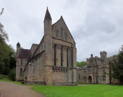
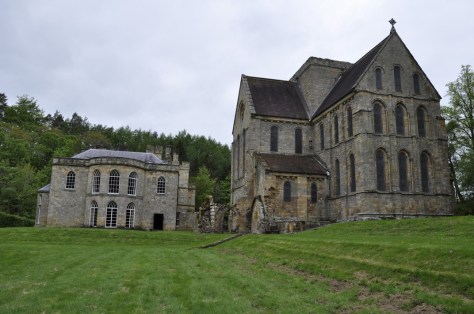


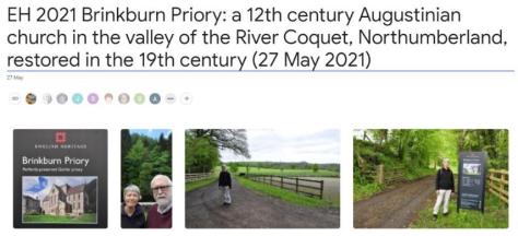


 As we sat on a bench, eating a picnic lunch and facing the west end of the priory church, I couldn’t help reflecting on the other ruined monasteries and the like that we have visited over the years:
  And a couple of days ago, after seven months here in the northeast of England (on the outskirts of Newcastle upon Tyne in North Tyneside), Steph and I took our first ride on the region’s Metro. Destination: Tynemouth, just six stations and 12 minutes from our nearest station, Northumberland Park.
 Earlier last week we upgraded our concessionary travel passes (CTP) to Gold Cards. With our CTP, we have unlimited free travel on buses nationwide, one of the benefits of being a senior citizen. For an extra £12 fee, we purchased unlimited travel on the Metro that we can use everyday, but only after 09:30 on weekdays. Here’s my CTP. Somehow my image was squashed; the original I submitted with my online application was fine.
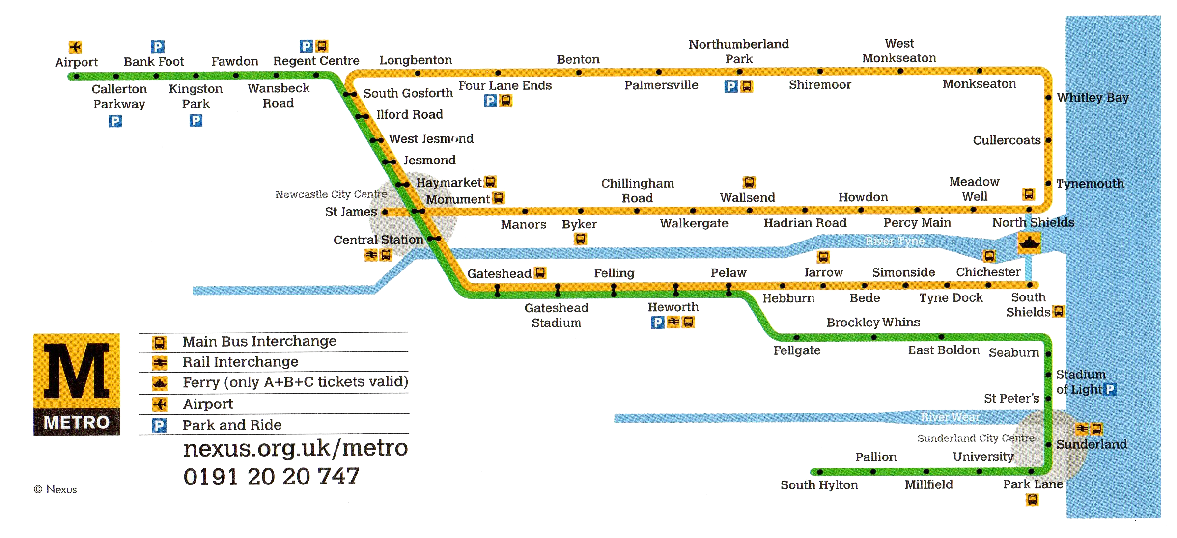


 This time, however, we had a particular Tynemouth destination in sight:


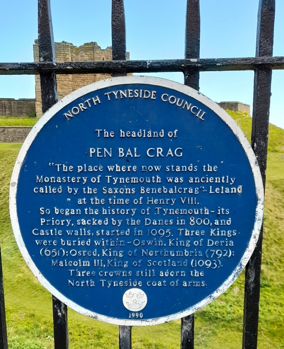


 When I retired in 2010, I briefly toyed with the idea of enrolling at the
  So much so that I then borrowed

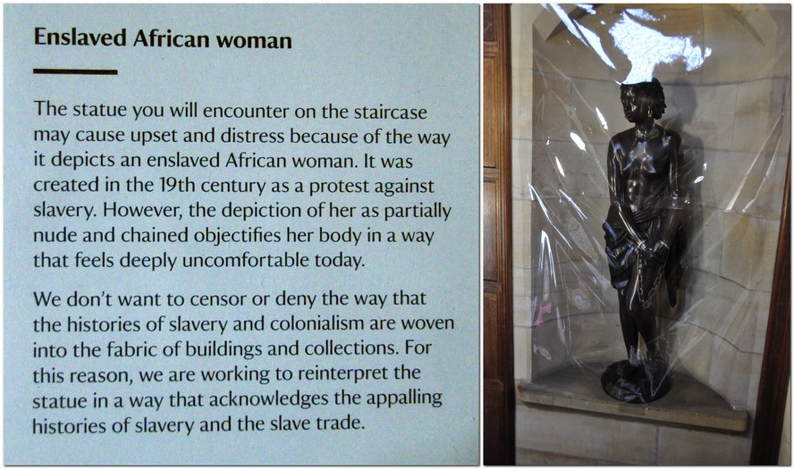
 At least one museum, the
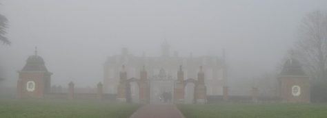


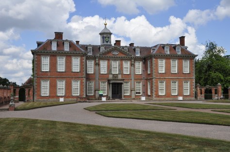


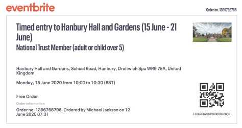


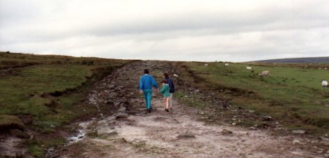


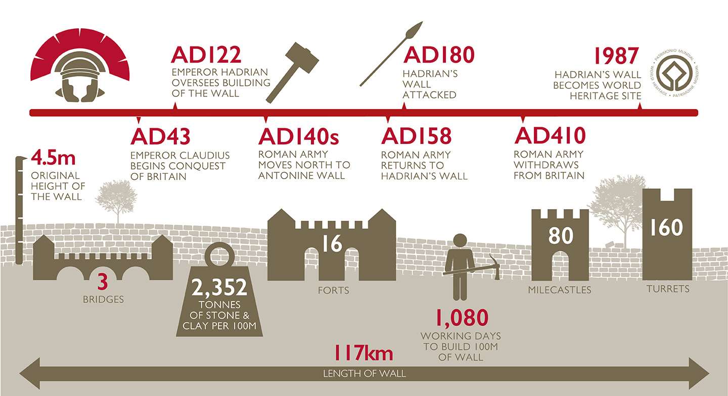

")


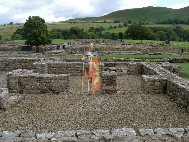


 But there is (or at least should be) another legacy of the Roman occupation here and elsewhere. It’s not a legacy that you can observe as such. It needs the techniques of molecular genetics to reveal it. DNA!


 A little further up the coast is Holy Island, the site of Lindisfarne Priory (owned by


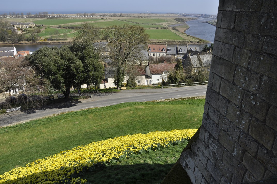
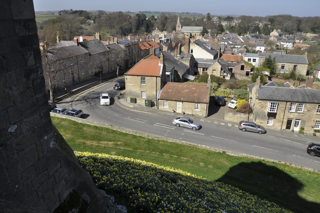


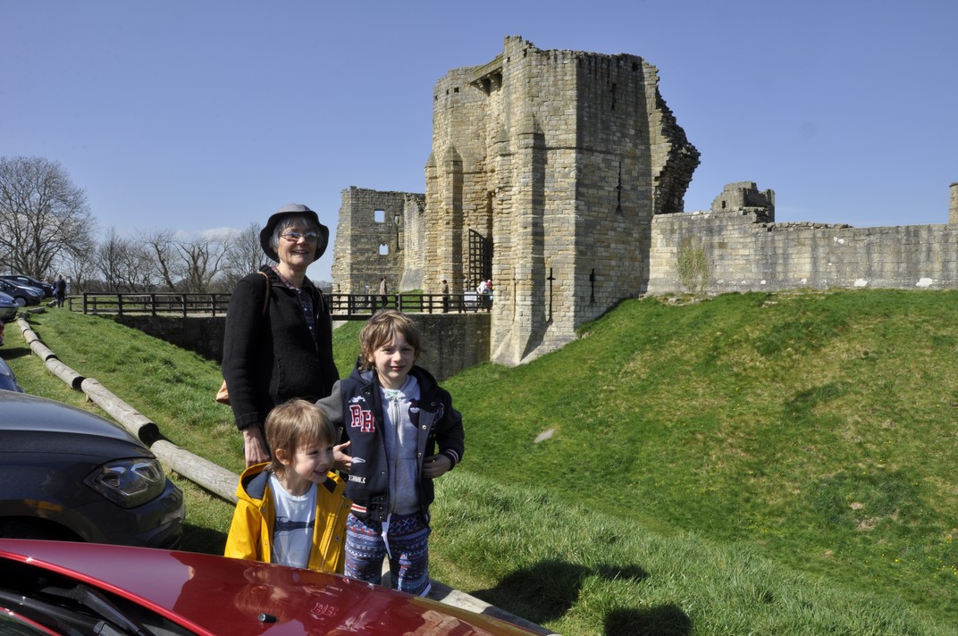

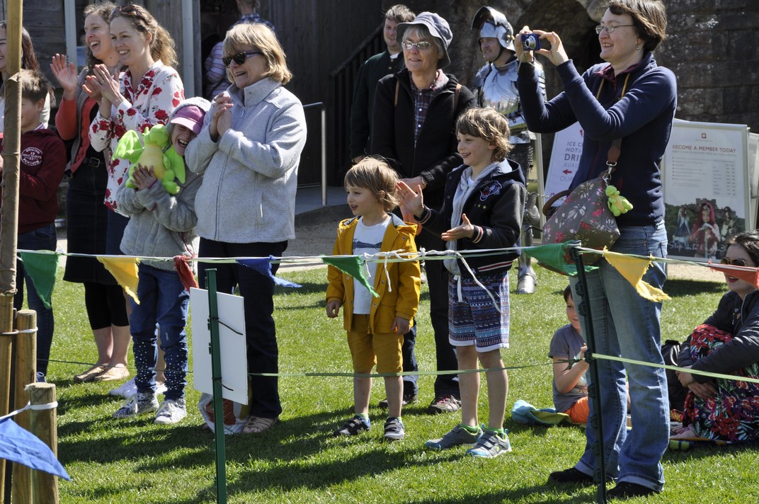
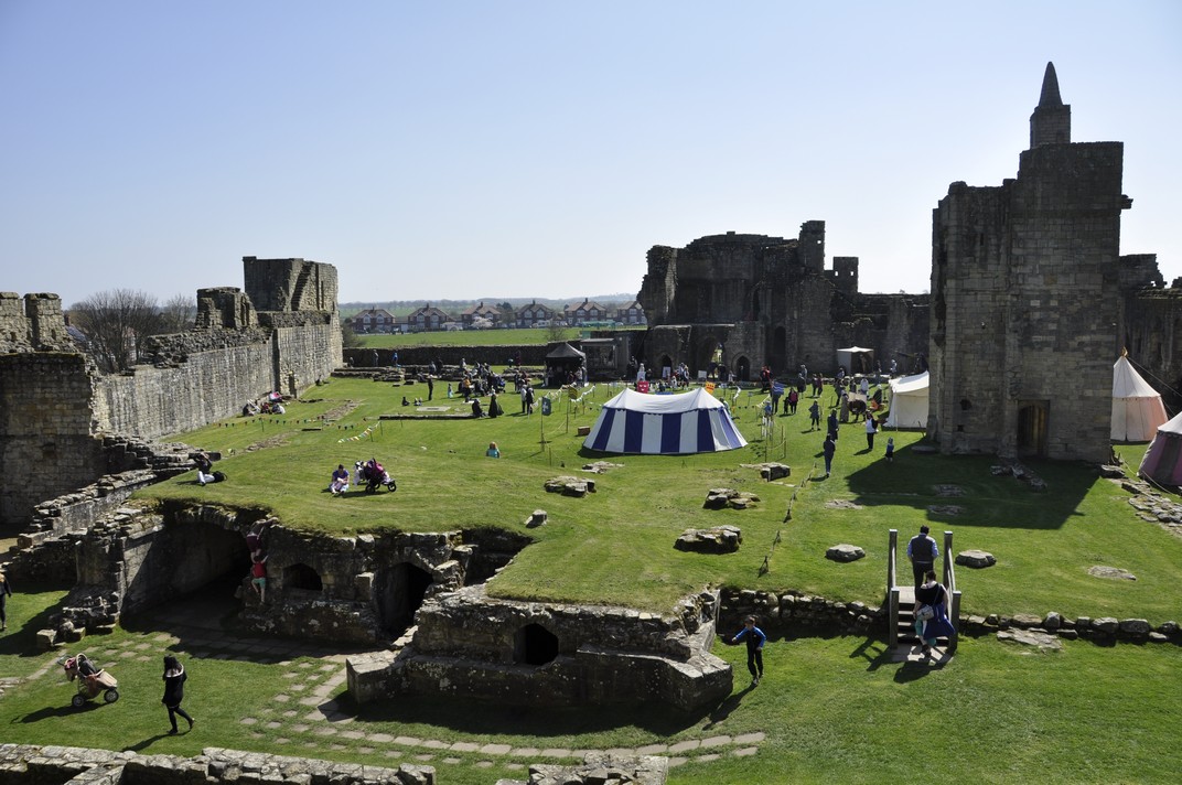


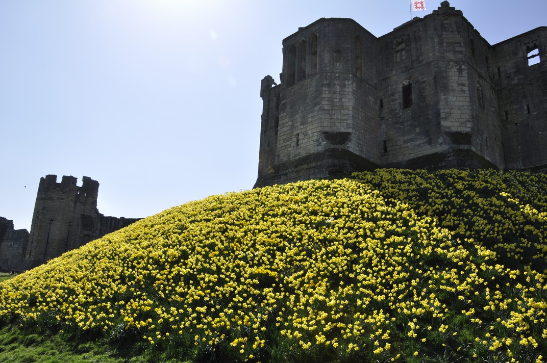
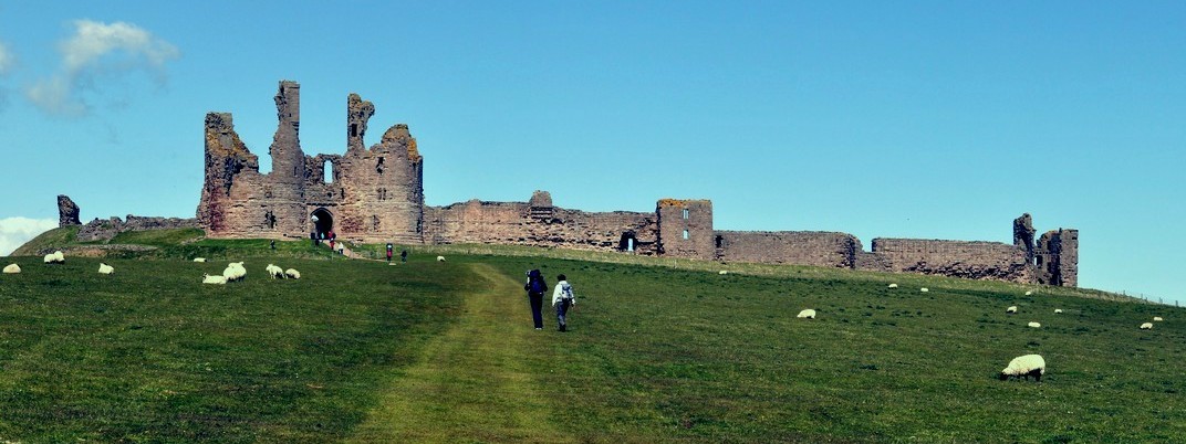
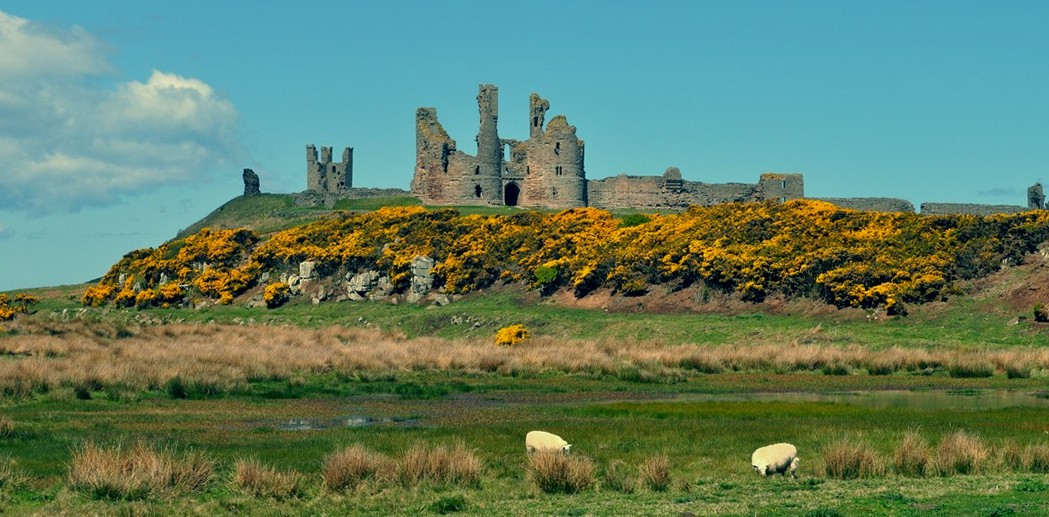
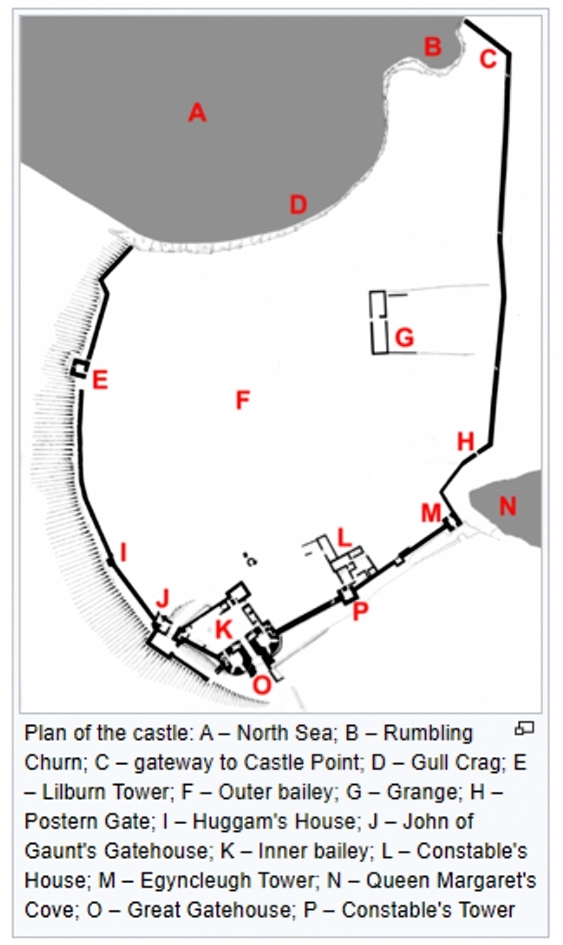


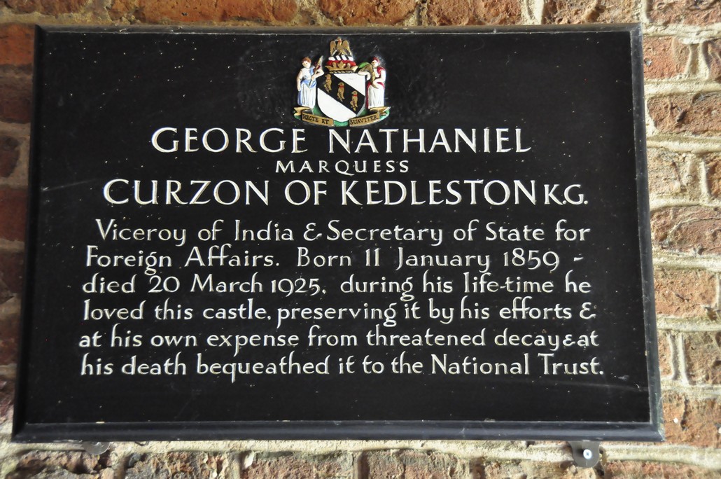


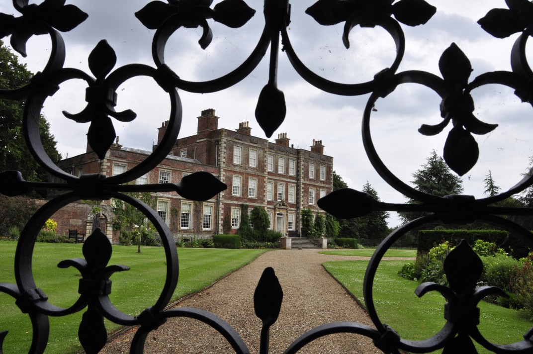


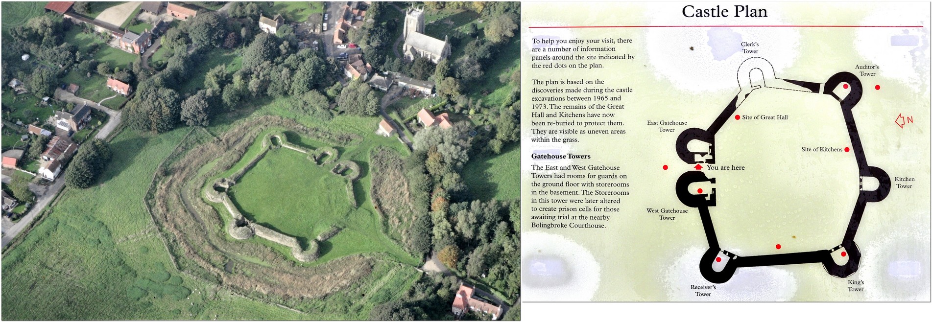


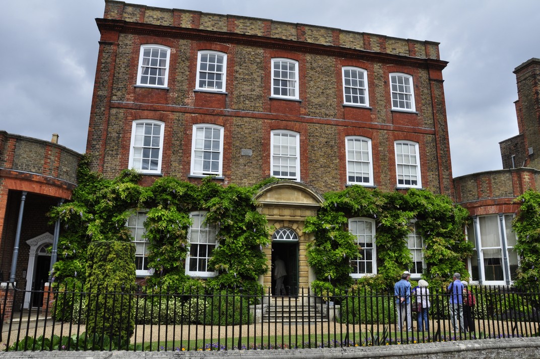


 The most celebrated of the family was Alexander (born in 1830) who traveled extensively and built
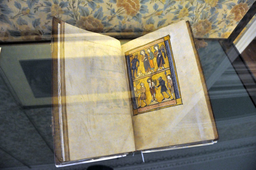


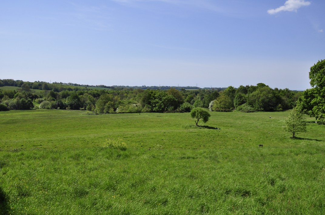
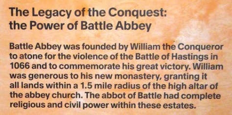
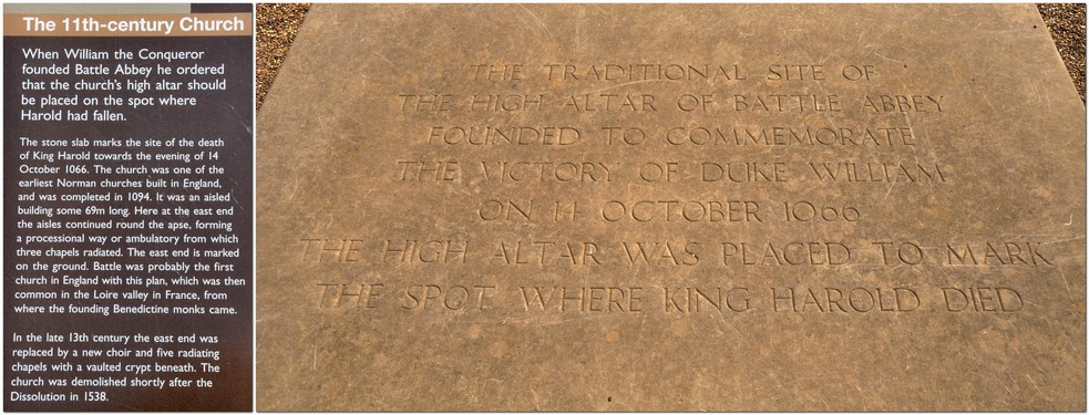

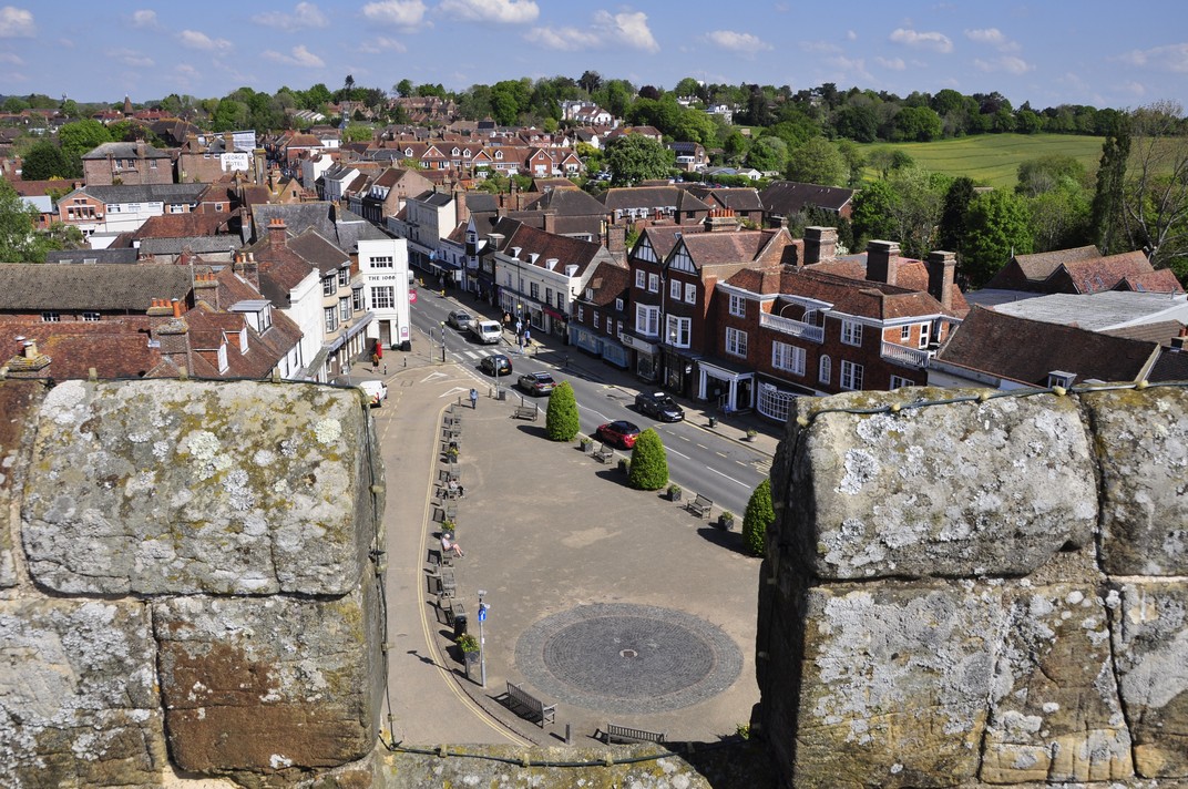

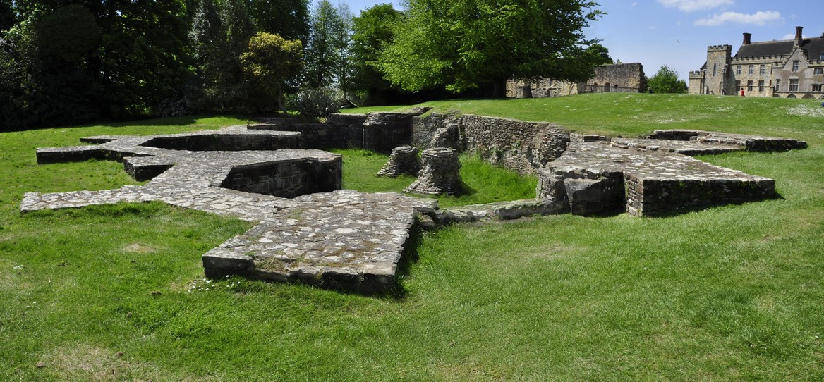
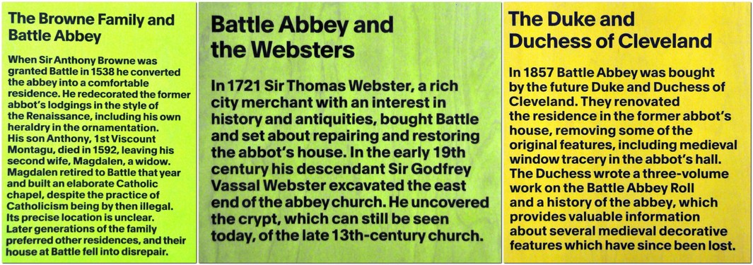
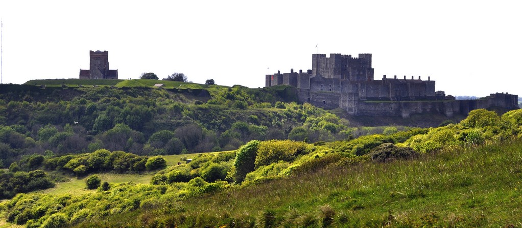
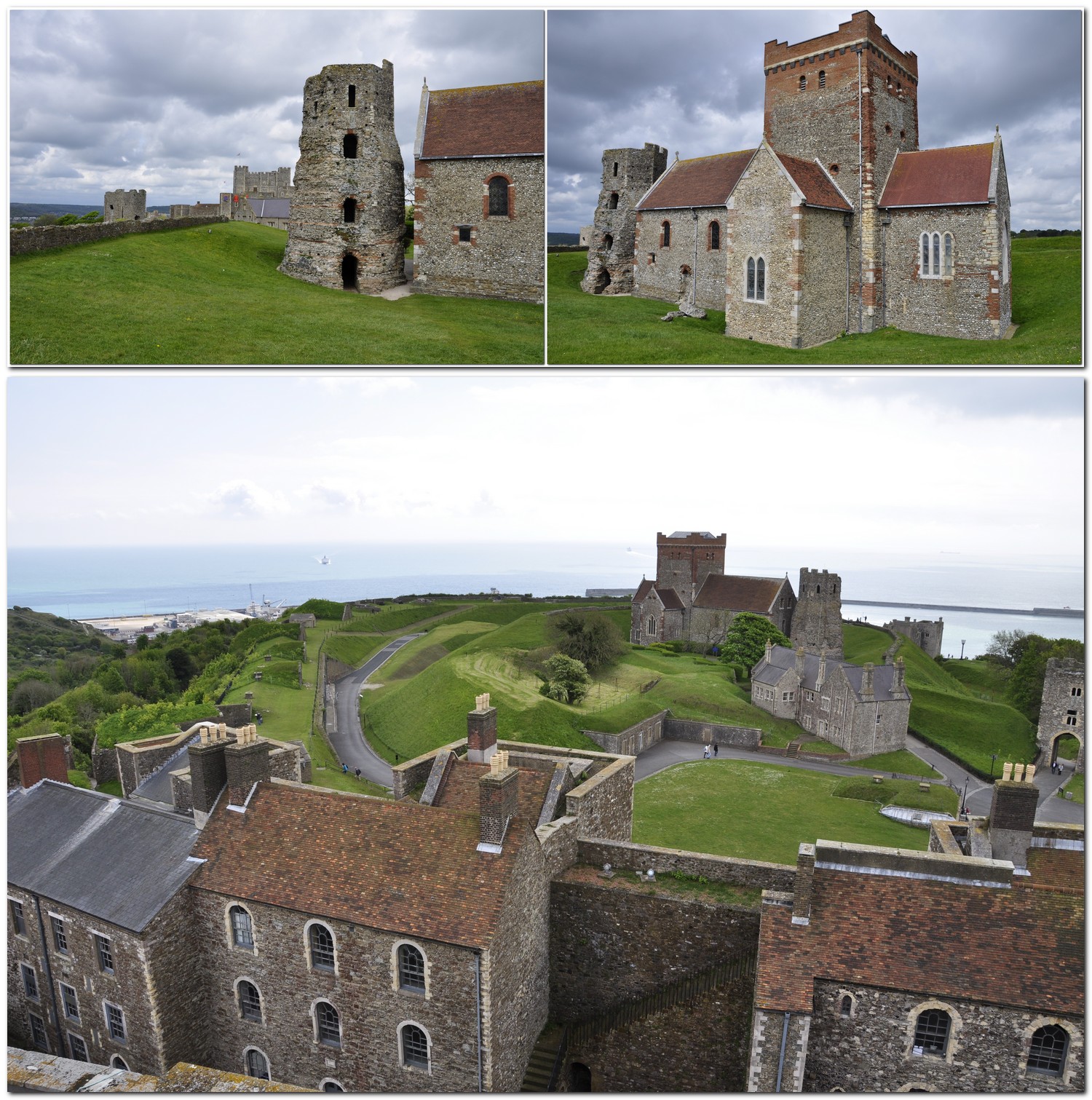


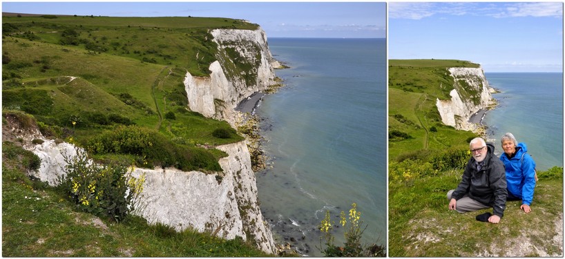
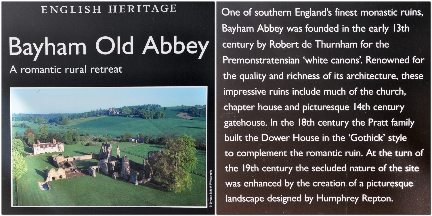
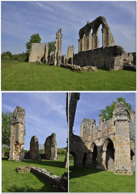
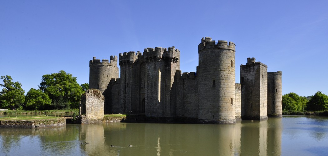


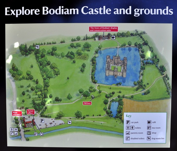
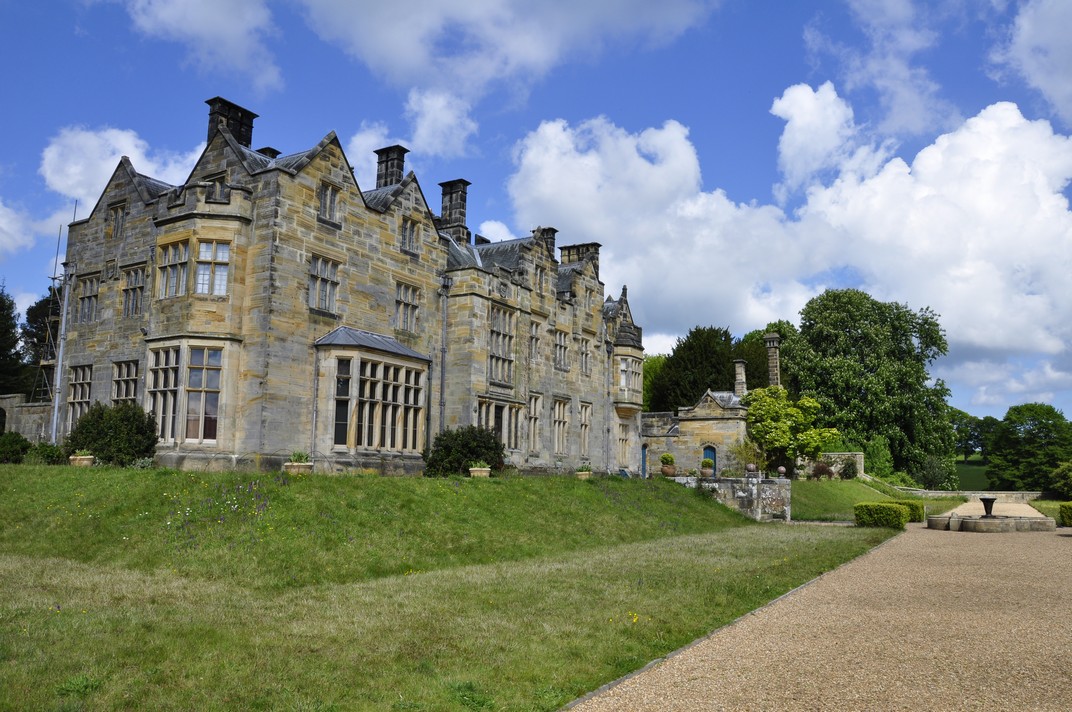
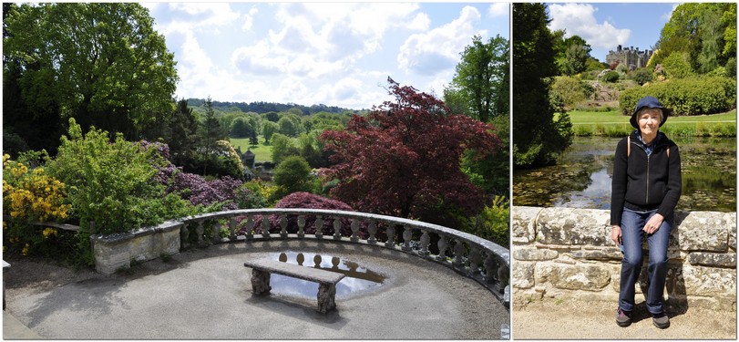


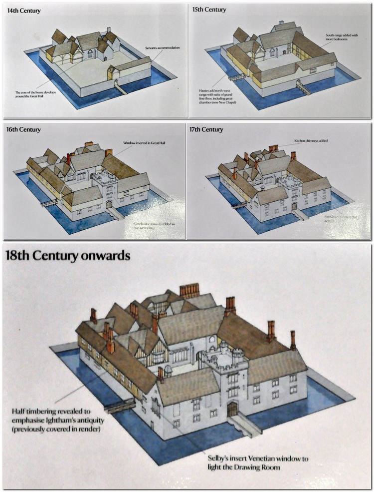
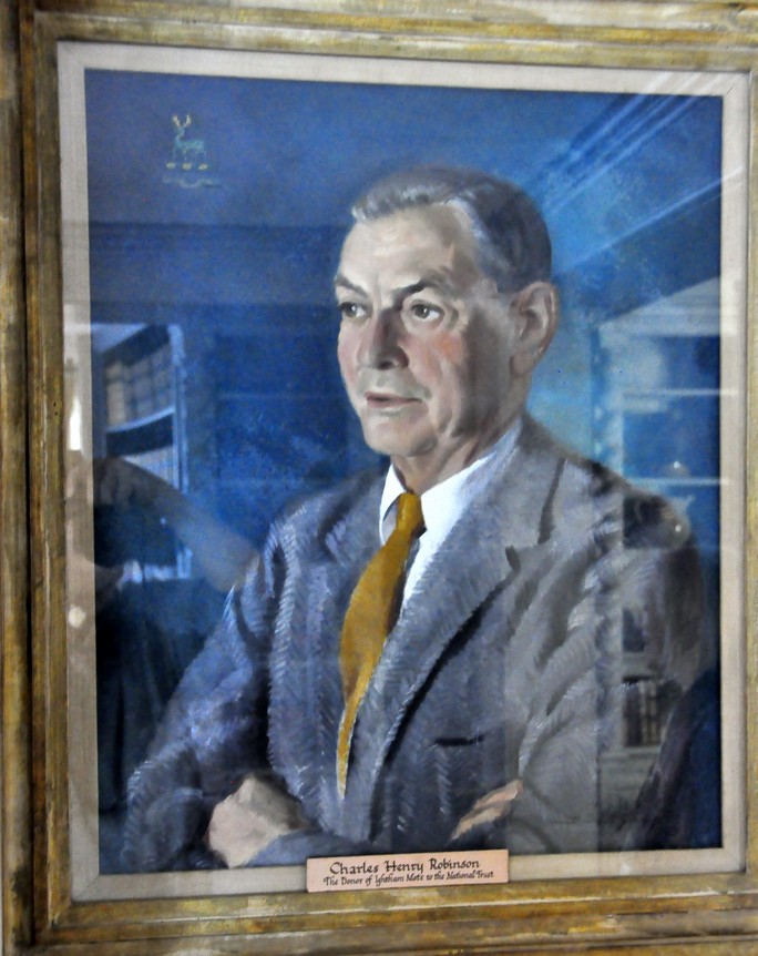


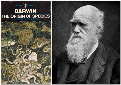
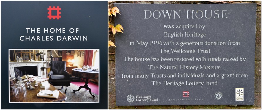


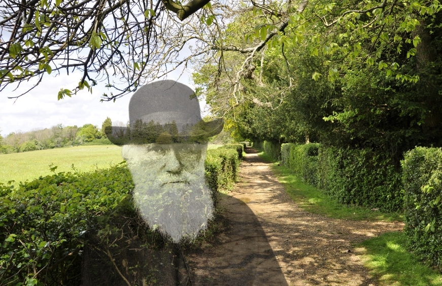
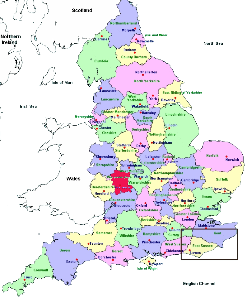
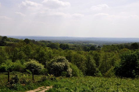


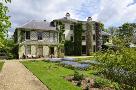

#/media/File:Prospect_Cottage,_Dungeness.jpg")
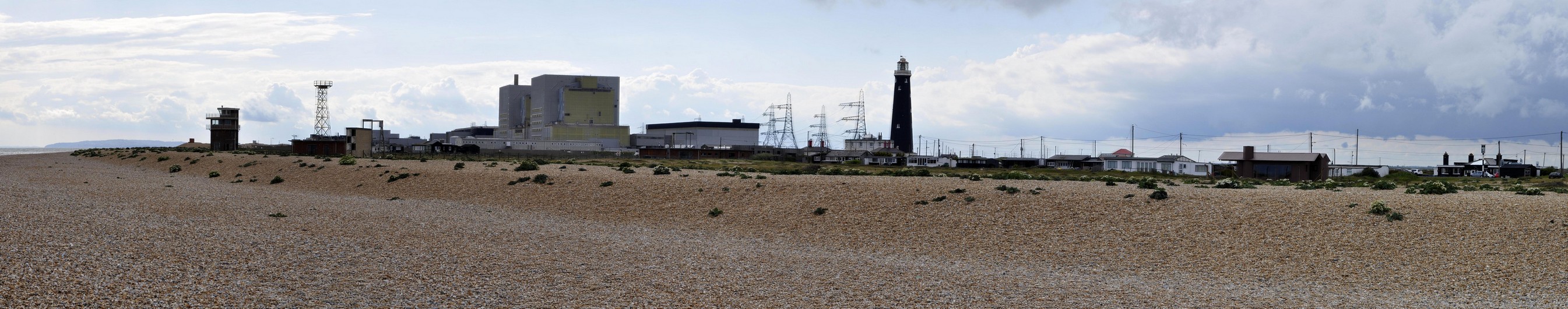

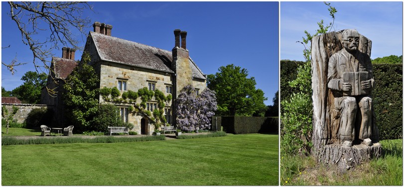

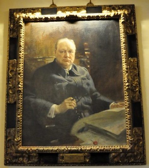
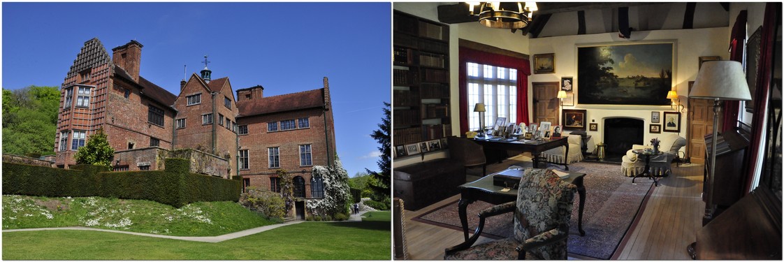
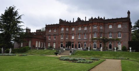

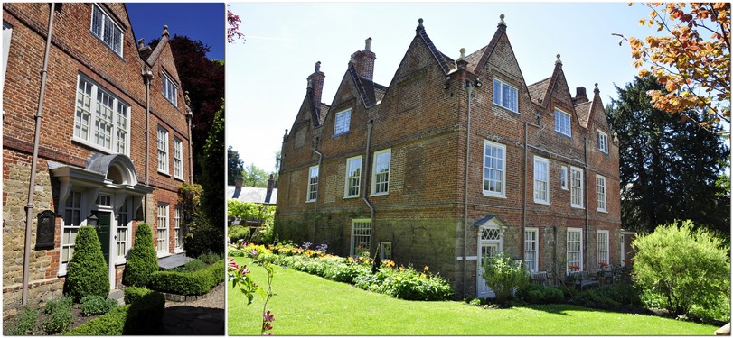


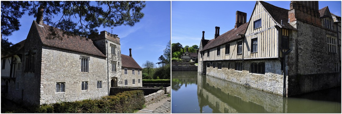
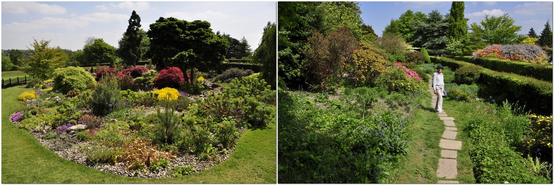
 Steph and I have been members of the
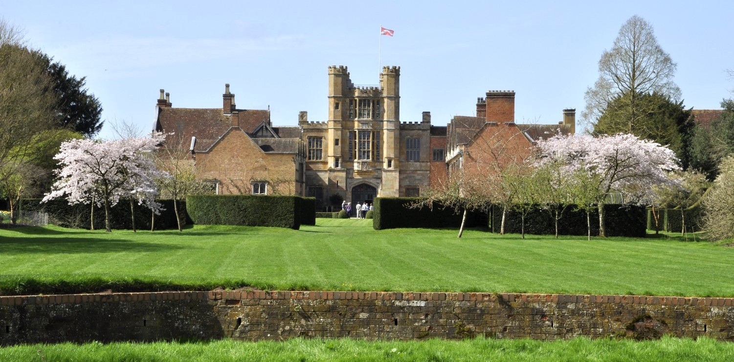


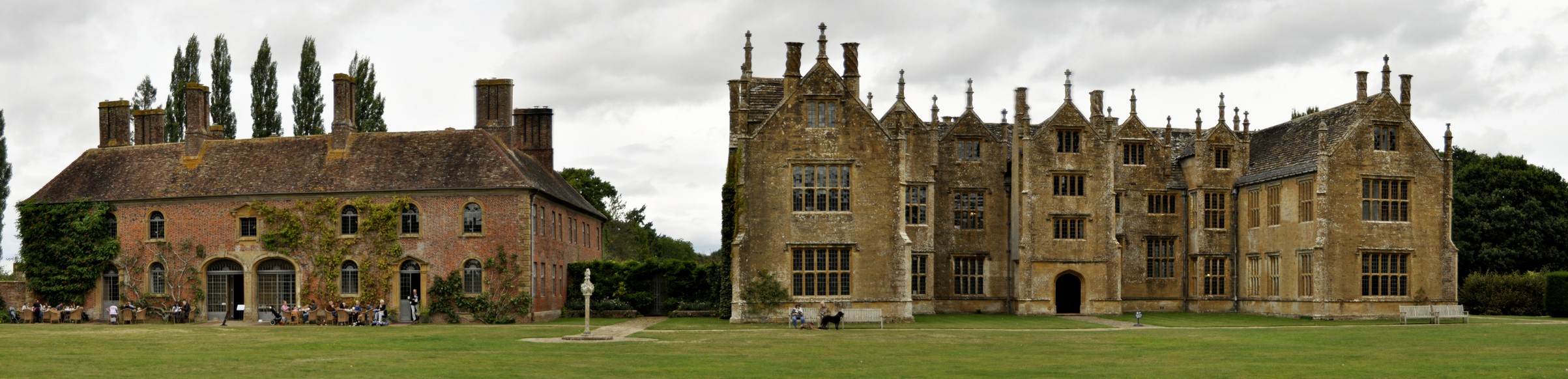


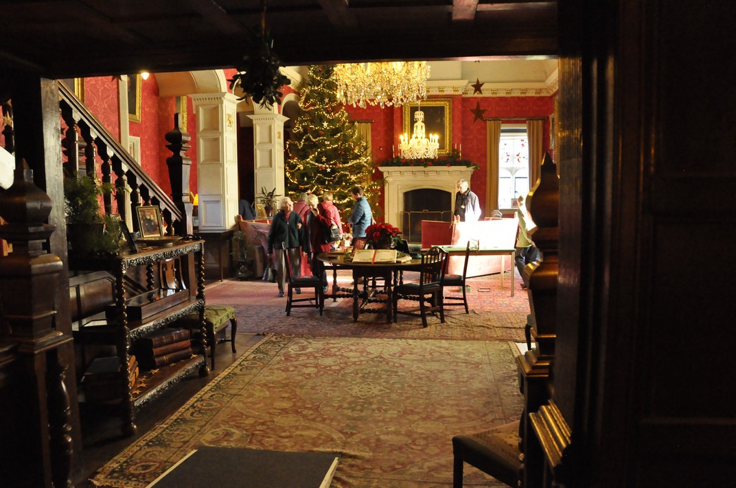


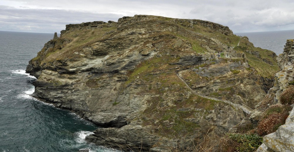

 Nestling under the Cleveland Hills in North Yorkshire, about half way between Thirsk and Middlesbrough along the A19 (

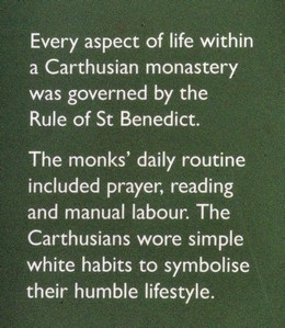


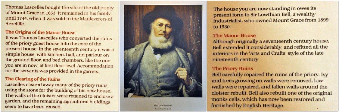


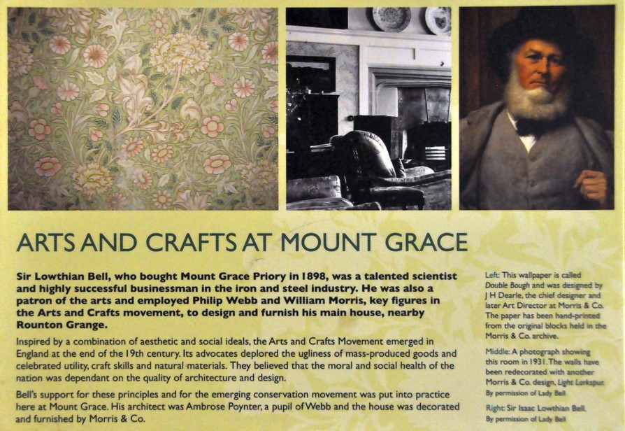


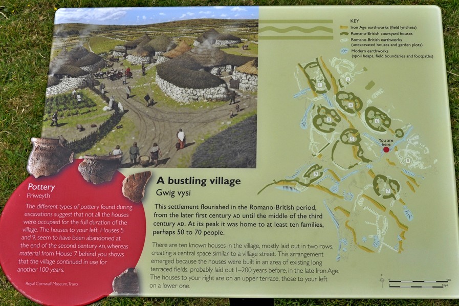
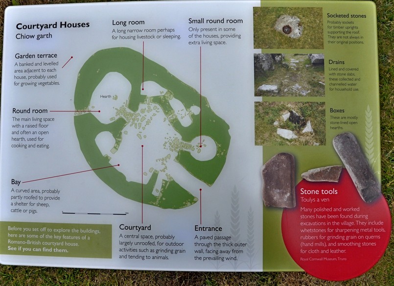
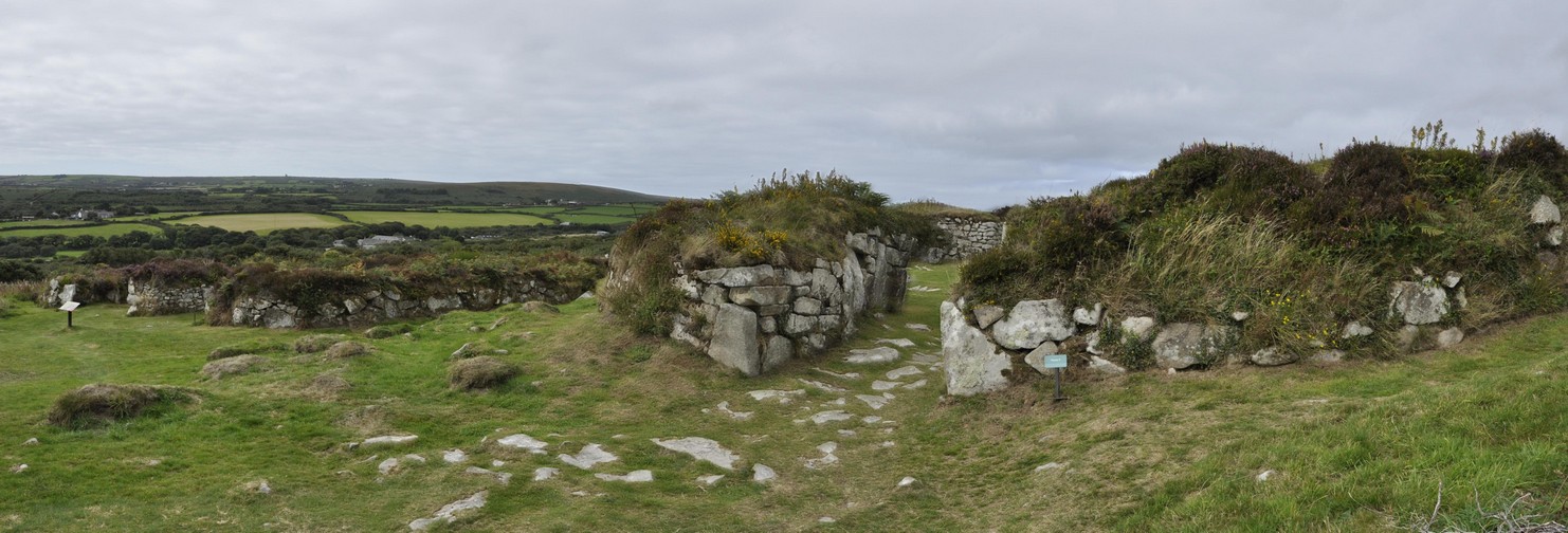
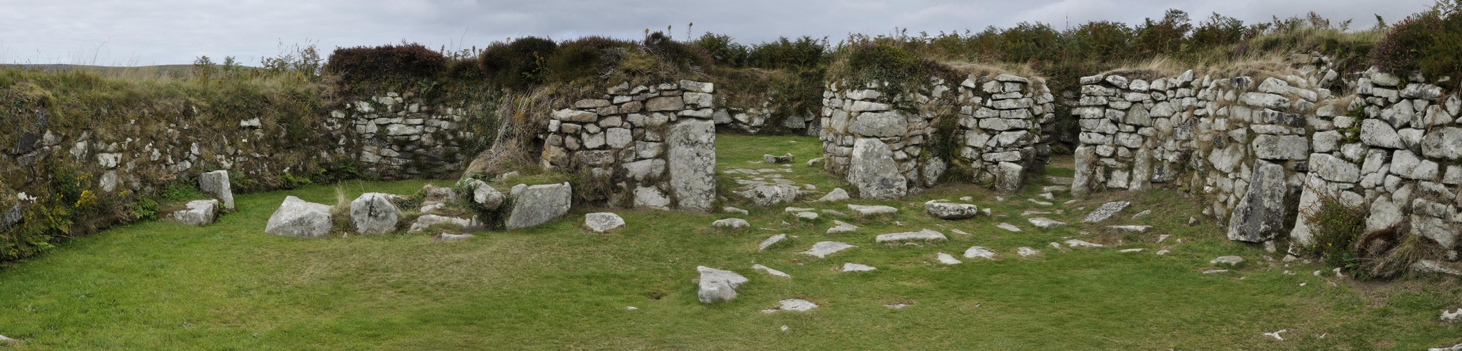


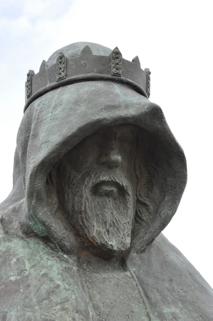
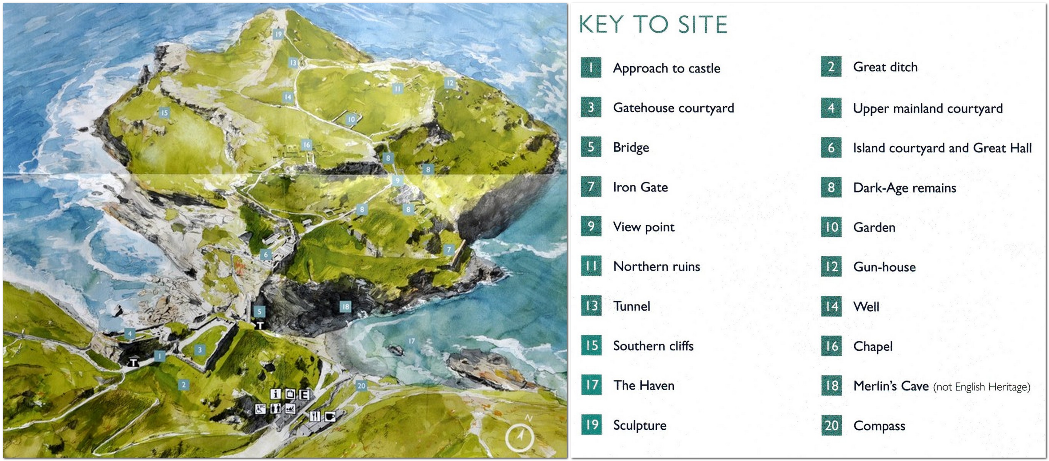
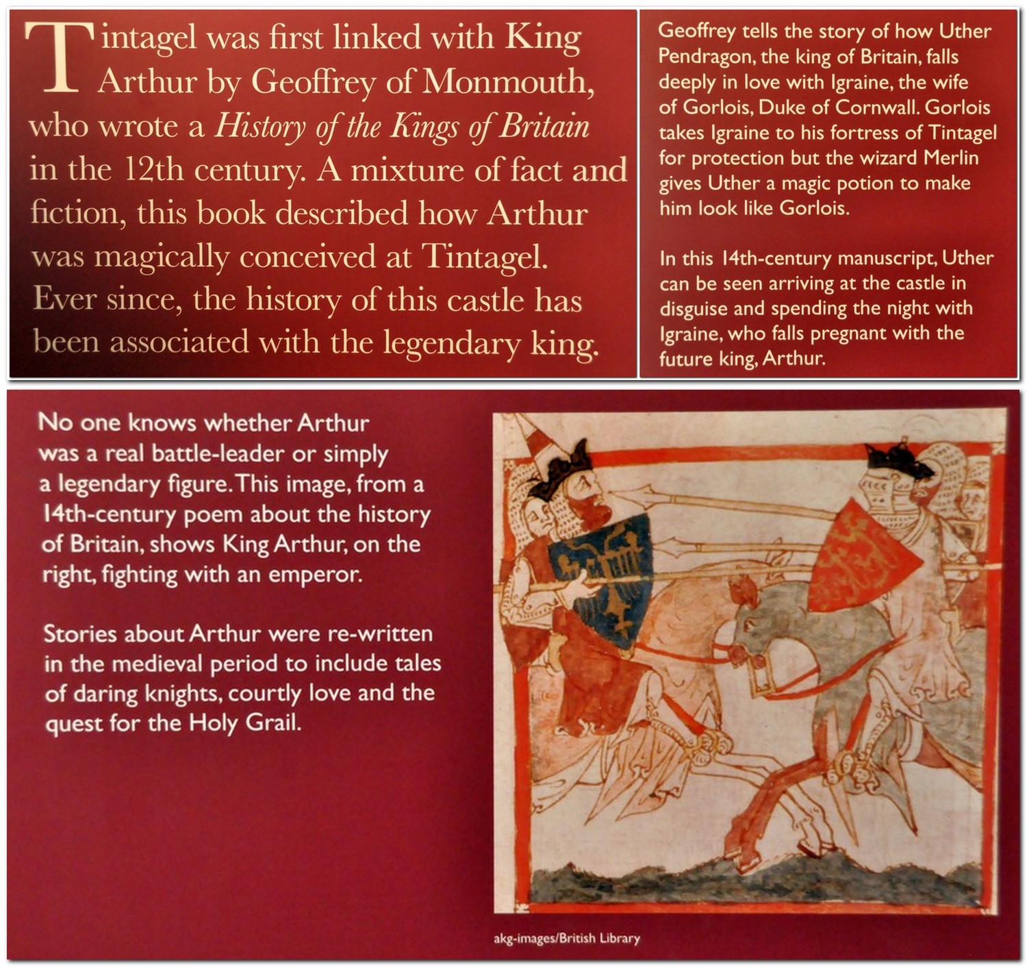
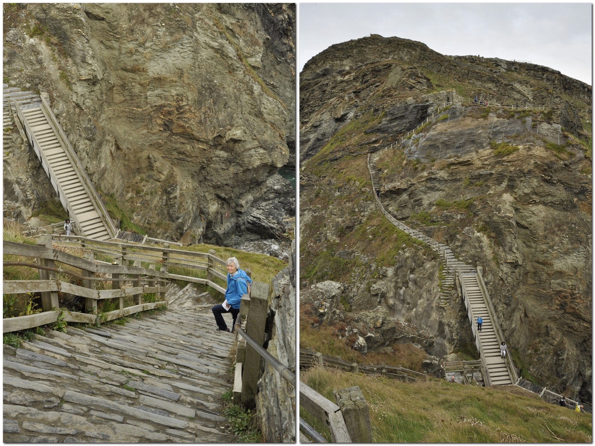
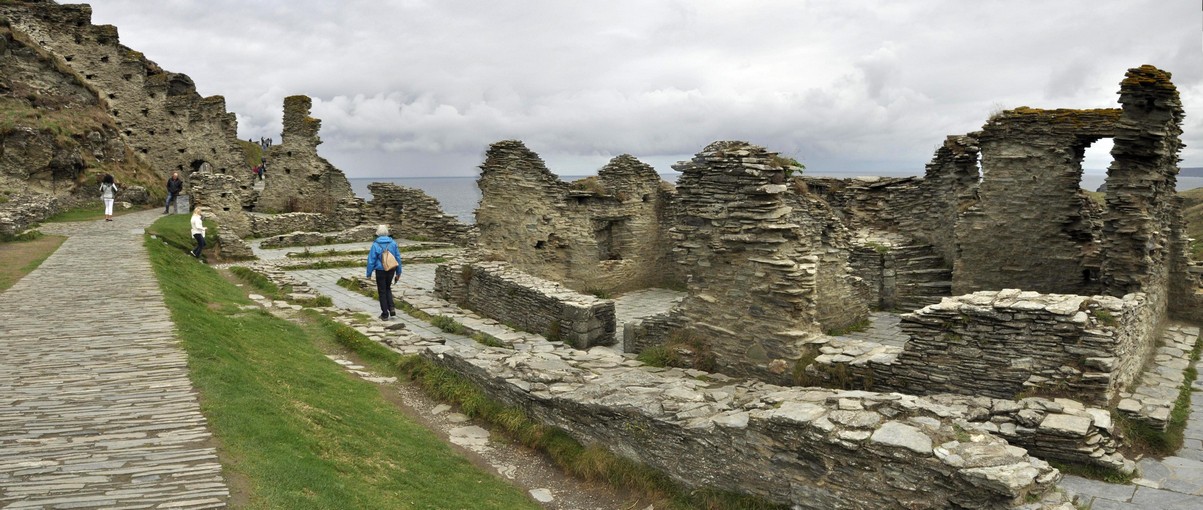
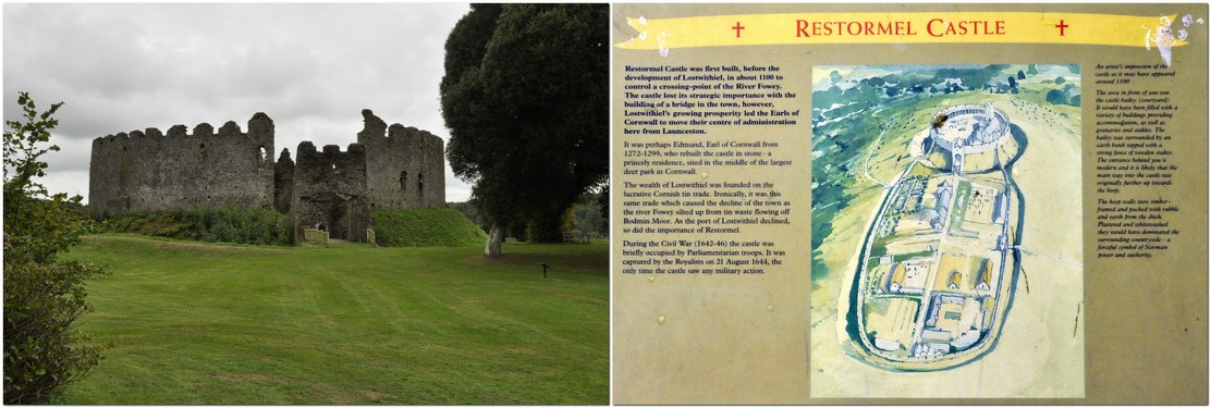
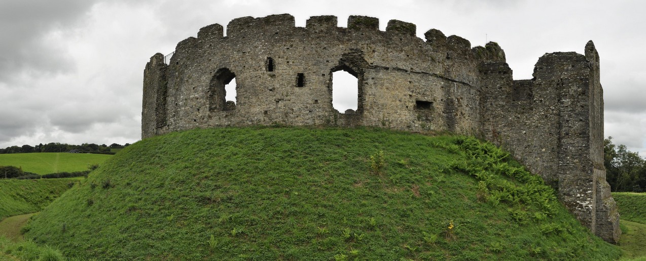
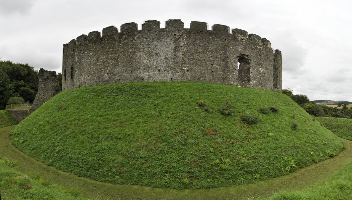
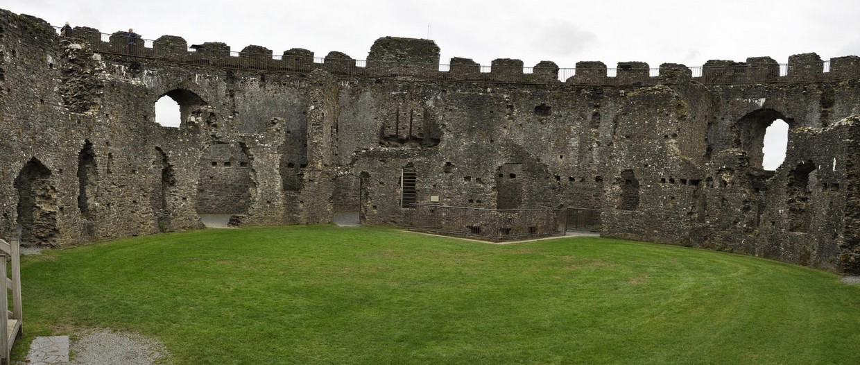
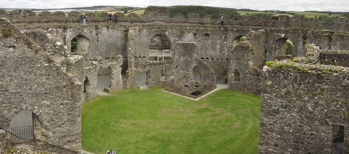
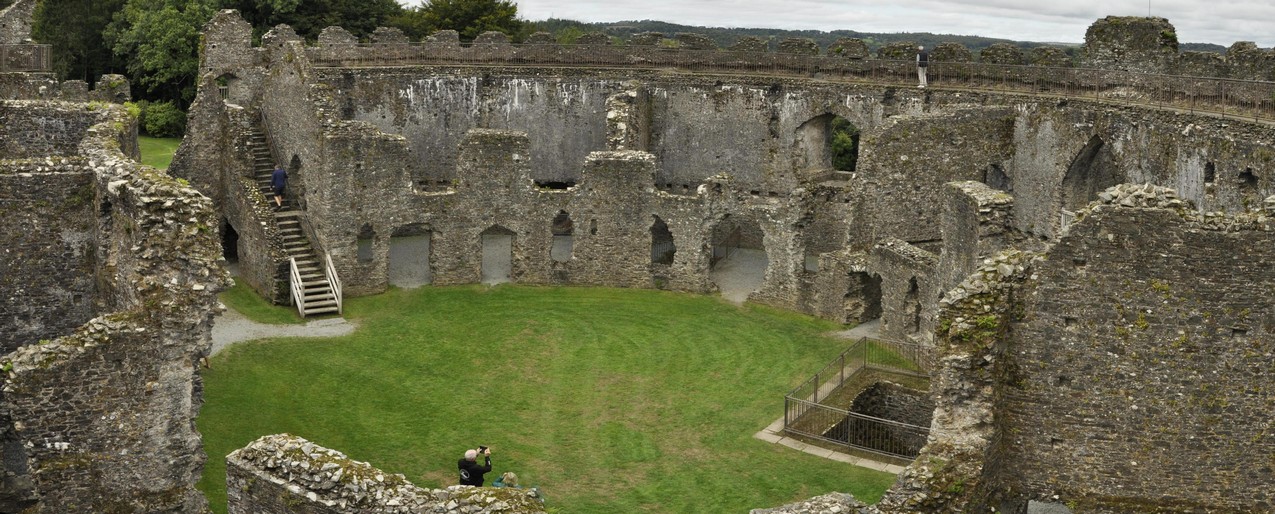
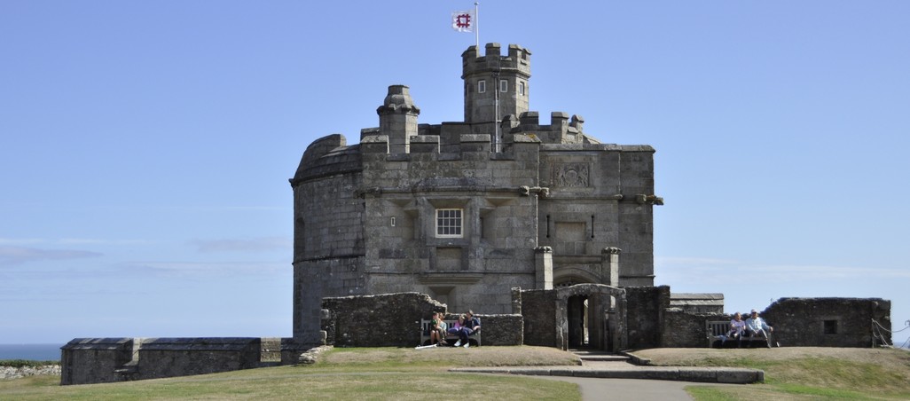
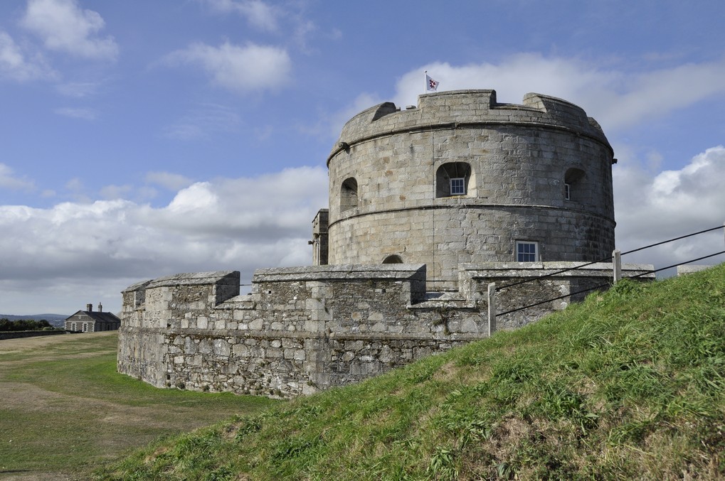
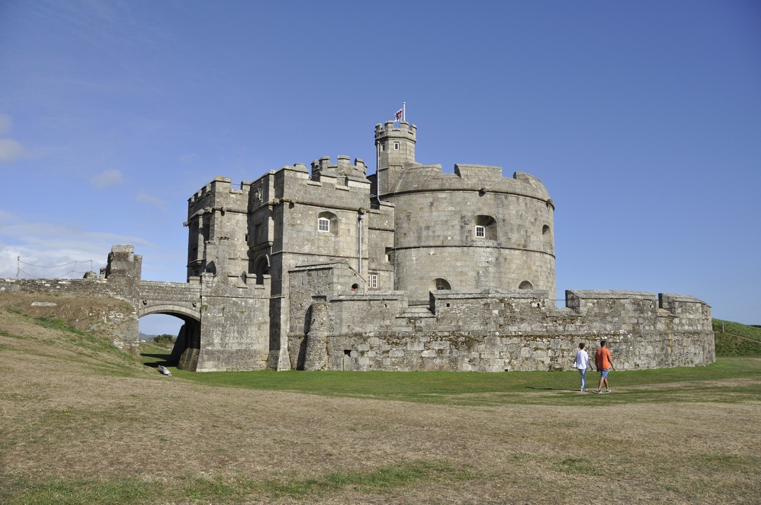
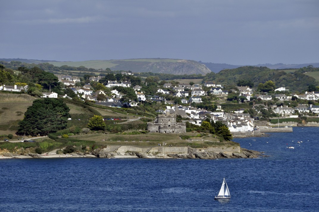
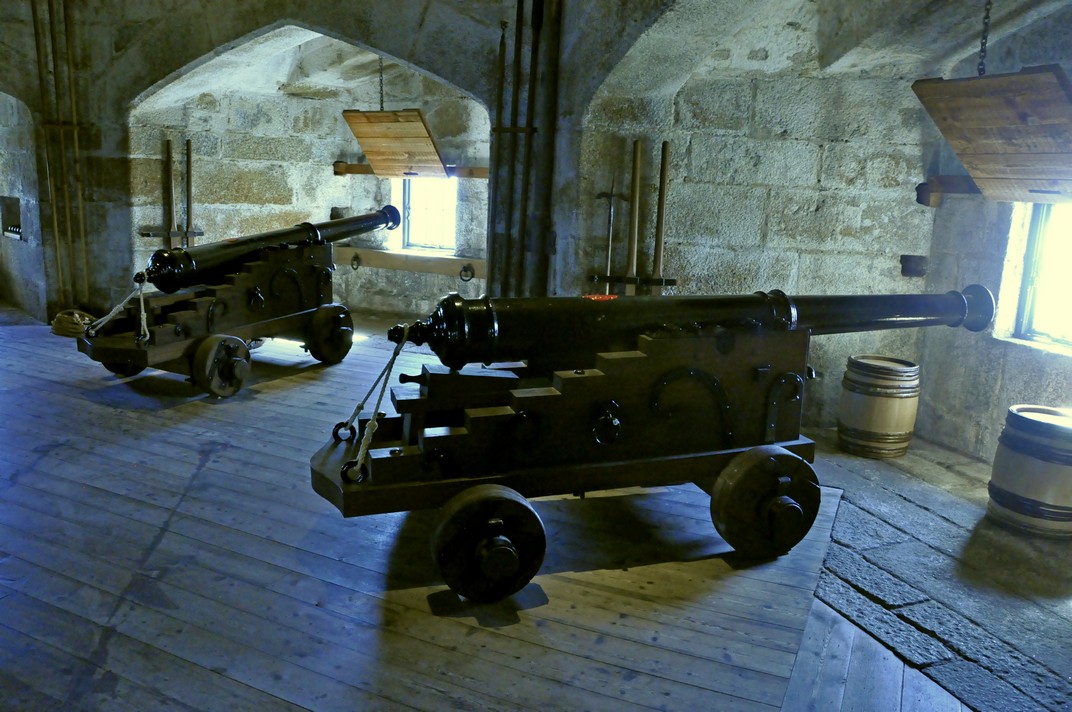
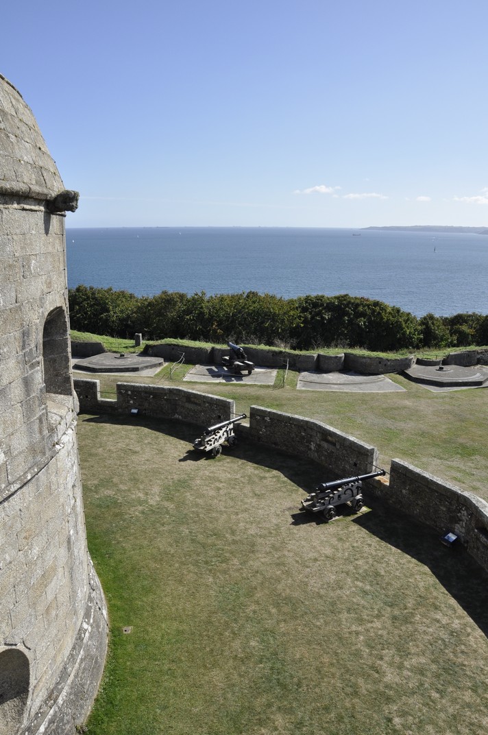
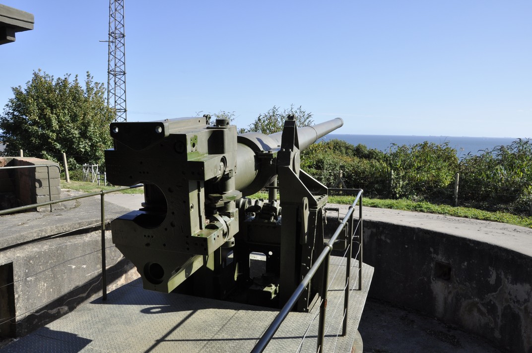
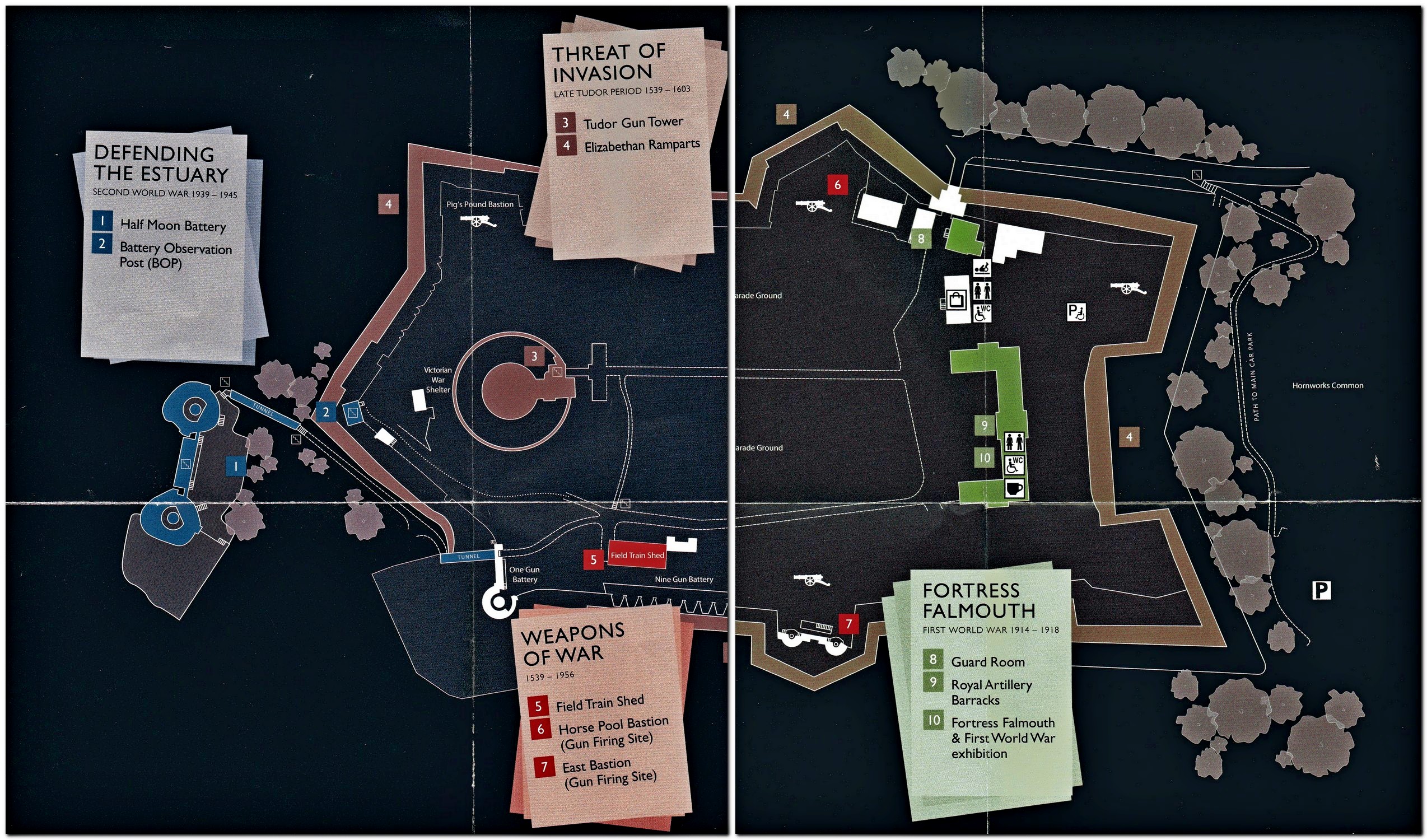
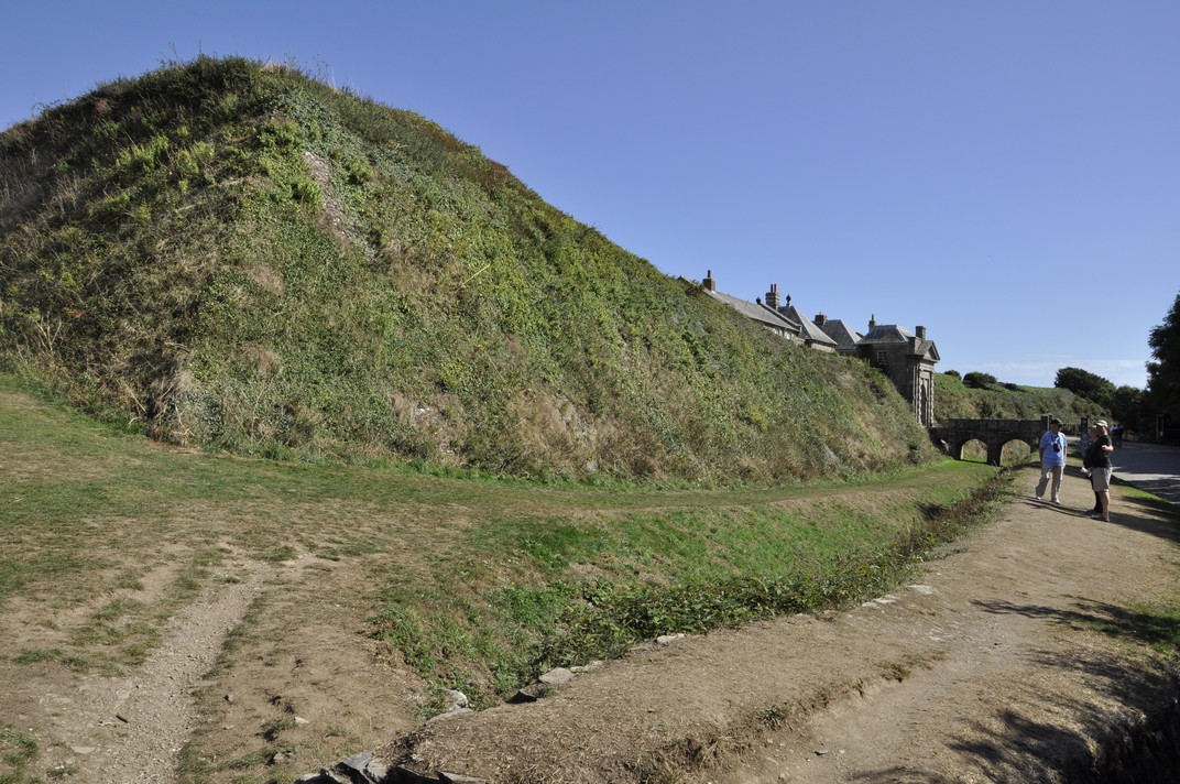
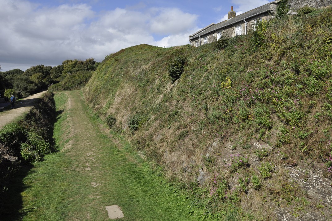
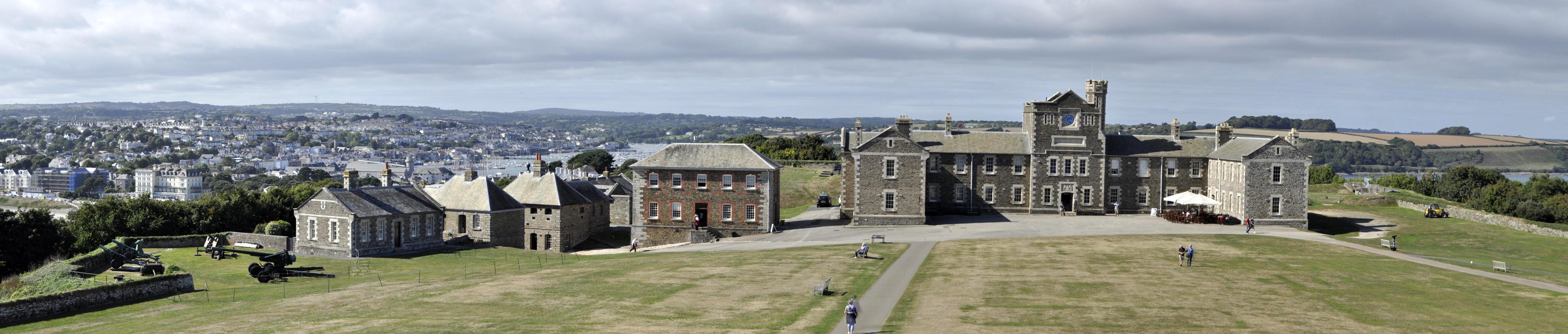
 We chose a small studio cottage, suitable for a couple, just north of Helston on the south coast, a round trip of more than 500 miles (including the side trips to a couple of National Trust properties on the way there and back – see
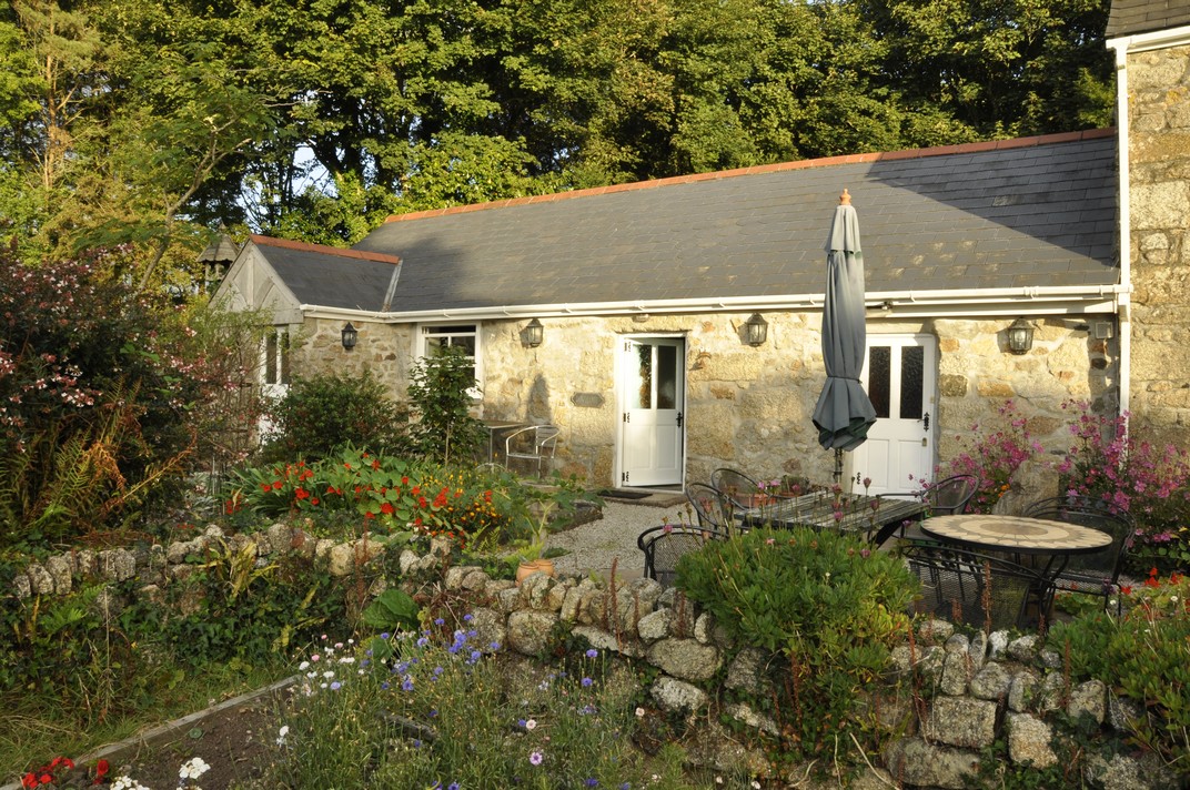


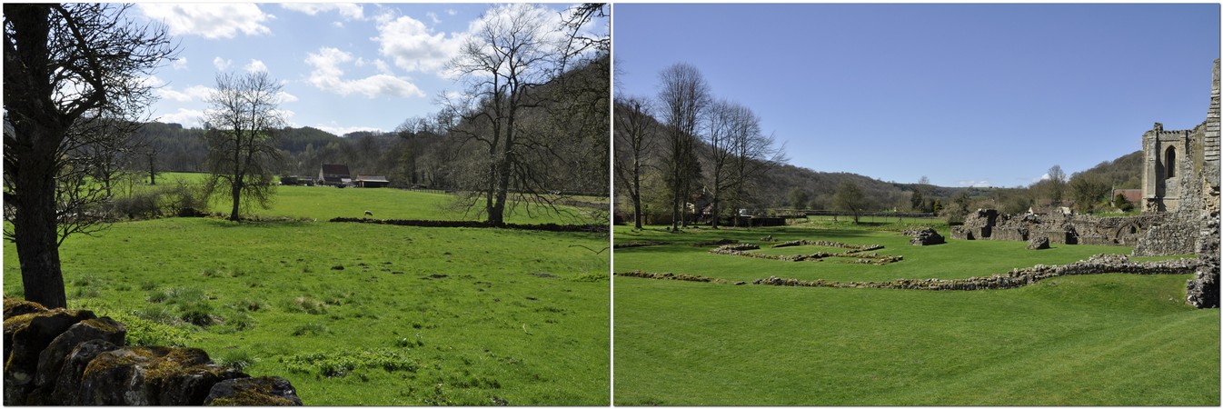
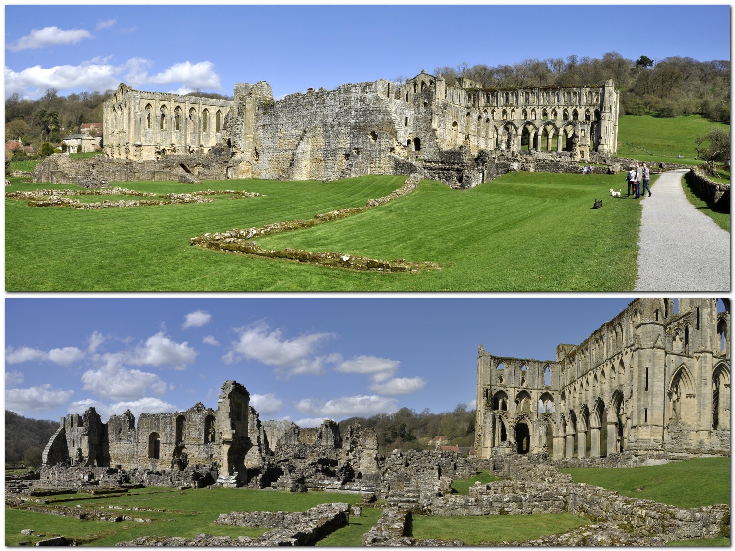
 It’s not my intention here to provide a detailed history of Rievaulx Abbey. English Heritage owns and manages the site, and a detailed history of Rievaulx’s founding and growth can be found on its