Once the weather improved in May and June, and we could get out and about more regularly, Steph and I visited several abbeys and priories managed by English Heritage that dot the landscape of this northeast corner of England, including Tynemouth Priory, Brinkburn Priory, Whitby Abbey, and Mount Grace Priory.
More recently, however, we’ve turned our attention to military historical sites, from the Romans (with visits to Chester’s Fort and Housesteads along the iconic Hadrian’s Wall) to the post-Norman conquest period of the late 11th century, with visits to Prudhoe Castle, Aydon Castle (more a fortified manor house), and most recently, Dunstanburgh Castle that proudly looks out over the North Sea on a windswept headland (home to the largest breeding colony of kittiwakes in Northumberland).
Northumberland has many castles, over 70 in fact. While most are ruins, shells of their former glory, some are still lived in today (such as Alnwick, Bamburgh, and Chillingham). All have played a significant role in British history, situated as they were at a great distance from the seat of power in London, along the border with Scotland (an independent country then), and prone to inter-familial conflict. Many castles and towers were also built for protection against the Border reivers, raiders from both England and Scotland who terrorized communities in the region.
Prudhoe Castle overlooks the River Tyne from a hill on the south bank, a little over 11 miles west of Gateshead (map).
The barony of Prudhoe had been granted to the d’Umfraville family, and construction of the castle began around 1100. It was this same family who built Harbottle Castle in the Upper Coquet valley that we visited a fortnight ago. It remained in the d’Umfraville family until 1381, when it passed by marriage to the Percy family, who became Earls and Dukes of Northumberland.
Prudhoe has an impressive gatehouse, with the room above converted to a chapel in the 13th century. The curtain wall encloses a large bailey or courtyard, and the remains of a substantial keep still stand on the west side. An 18th century manor house stands in front of the keep and now houses the offices of English Heritage and a museum.
Prudhoe castle from the pele yard, English Heritage
The dry moat
Prudhoe’s curtain wall on the north side, overlooking the River Tyne
Approaching the gatehouse
Looking back from the gatehouse
Inside the bailey
The gatehouse from the bailey
the 13th century chapel above the gatehouse
The bailey
the 18th century mansion house
The remains of the keep
Stairway inside the wall of the keep
I have posted more photos of the castle here, together with images (with descriptions) taken in the museum.
About 7 miles northwest from Prudhoe, as the crow flies, the fortified manor house of Aydon Castle occupies a site overlooking a small stream known as the Cor Burn (map). Its construction began in the late 13th century.
It’s remarkably intact, because since the 17th century it was used as a farmhouse, and apparently still occupied until the mid-1960s.
There is an outer courtyard, with enclosed battlements on the curtain wall surrounding the site, if the model of the house has been interpreted correctly (rather like those we saw at Stokesay Castle in Shropshire in 2015 (below).
Model of Aydon Castle, with enclosed battlements on two walls.
Stokesay Castle, Shropshire
English Heritage has carefully removed the wall paneling and room partitions that were in place when the house was most recently occupied. So you get a real sense of what Aydon Castle must have been like in its fortified heyday.
And there are more images and building plans here.
We have visited 14th century Dunstanburgh Castle several times, but this visit less than a month ago in mid-July was the first time we had ventured this far north since moving to the northeast last October (map).
There’s not too much of the castle left standing, apart from the main gatehouse, and a couple of towers on the east and north sides of the bailey. But the location is spectacular, and the cliffs teem with seabirds.
National Trust Dunstanburgh Castle
Even though the ruins themselves are not extensive, it’s perhaps the enjoyment of the walk from the village of Craster, some 1½ miles to the south, that attracts so many visitors. And, the Craster kippers of course.
The view south towards Craster from the ramparts of Dunstanburgh Castle.
For the past couple of months I’ve delved into Roman military fiction by British authors Simon Scarrow and Harry Sidebottom. Several of their books are set on the fringes of the Roman empire, including references to the conquest and settlement of the British Isles two millennia ago.
I’ve been to Rome more times than I can remember, always in a work capacity. Having said that, I often tried to time my arrival in Rome to give me a free weekend to explore the city, mostly on foot. Rome is a great city for walking around. History and archaeology are everywhere. And it has never ceased to amaze me just how Rome was, for hundreds of years, the hub of one of the world’s largest and most powerful empires.
Here are just a few views of ancient Rome, from the Circus Maximus, the Palatine Hill, the Arch of Constantine, the Via Sacra, the Colosseum, and the Pantheon.
Throughout England, less so in Wales and Scotland, the reminders of Roman occupation can be seen everywhere, from the towns they founded such as Londinium (London), Camulodunum (Colchester), Corinium (Cirencester); the roads they built (still evidenced today in several important highways such as Ermine Street and Watling Street, to name just two), the villas they left behind (such as Fishbourne Palace in West Sussex or Chedworth in Gloucestershire), the various garrison towns like Viriconium (Wroxeter) in Shropshire and Vindolandain Northumberland, and last but not least, perhaps the most famous landmark of all: Hadrian’s Wall stretching more than 70 miles from coast to coast across northern England.
The Romans did venture further north into Scotland, and built the Antonine Wall from the Clyde in the west to the Forth in the east. Construction began around AD142, but it was abandoned after only eight years. And so Hadrian’s Wall became the de facto northern boundary of the Roman occupation of Britain: Roman territory to the south, land of the barbarians to the north.
Steph is standing astride the north gate entrance at Chesters Roman Fort on Hadrian’s Wall: barbarians to the north (left foot), Romans to the south (right foot).
Our outing at the end of June took in two sites along Hadrian’s Wall: Chesters Roman Fort near Chollerford (map) and a little further west, Housesteads Roman Fort, one of the best examples of an auxiliary fort anywhere in Europe. And, between the two, and beside the invisible remains of Carrawburgh Fort (also know as Brocolita), stand the ruins of the small Temple of Mithras. All sites are maintained by English Heritage. We’ve been to Housesteads and the Temple at least twice before, but this was our first visit to Chesters. We weren’t disappointed.
Much of our understanding of the history and archaeology of Hadrian’s Wall is down to one man in the nineteenth century: John Clayton (1792-1890), the town clerk of Newcastle upon Tyne. He came from a wealthy family, acquired much of the land on which the Wall and other sites stand, and over a fifty year period beginning in 1840, he excavated much of what we see today (with the exception of Vindolanda where there is an active excavation and many remarkable finds still being unearthed). Many of the best pieces are now displayed in a museum named after Clayton that was opened by his family in 1896 after his death.
Chesters Roman Fort As with many Roman sites, only the outline of buildings can be seen, just a few feet high. Nevertheless, it’s possible to take in just what the site might have looked like in its heyday. And English Heritage kindly provides reconstructions of what the buildings and overall site might have looked like on display boards around the site—as they do at Housesteads and elsewhere.
We entered through the North Gate, and immediately made our way to baths on the east side of the fort, where the land slopes down to the North Tyne river. The Romans certainly knew how to choose the right spots to build their forts. But at this point the river was easily fordable, and a bridge (no longer standing) was built across the river to connect with Hadrian’s Wall on both banks.
Valley of the North Tyne at Chesters Roman Fort
Remains of Hadrian’s Wall on the east bank of the North Tyne, and immediately opposite the East Gate at Chesters Roman Fort
Chesters was primarily a cavalry fort, and there are the remains of stable barracks on the northeast corner of the fort. Elsewhere the commanding officer’s house gives some indications still of how much better he must have lived with his family than the ordinary troops. There are remains of underfloor heating and the like that must have made living in the harsh climate of Northumberland that little bit more bearable. Just beyond the commanding officer’s house, closer to the river are the ruins of the substantial bathhouse.
Barracks
Commanding officer’s house
Underfloor heating
Underfloor heating
Underfloor heating at Chester’s Roman Fort (English Heritage)
Bathhouse
Bathhouse
Bathhouse
Bathhouse
Housesteads
It’s a half mile walk uphill from the car park beside the B6318 to the main entrance to the fort. The English Heritage shop and cafe are next to the car park.
What is particularly impressive about Housesteads is its remote location. There are spectacular views from the fort over the surrounding Northumberland landscape, in all directions. And the fort and Hadrian’s Wall are intimately connected. It must have been an important site along the wall, in defence of the empire.
Among the more intact buildings is the granary, that was used to dry or keep dry any cereals and presumably other perishables.
At the bottom of the slope, in the southeast corner stand the remains of the communal latrine, which must be one of the best preserved examples.
We didn’t visit the museum close by the fort during this visit. I had seen evidence displayed there—or was it at Vindolanda just over two miles away to the southwest?—of letters received or never sent by a soldier who hailed from Syria or somewhere in that region. Roman auxiliaries came from all over the empire, and could acquire citizenship after more than 20 years service. So, as I’ve commented elsewhere, the Romans must have left more behind than just impressive ruins. Their legacy lives on in the genetics of this part of the country.
On a bright and sunny day when we visited in June, Housesteads is a great destination for all the family. From what we experienced that day, children were having a great time exploring the fort—especially the latrine! Given its exposed location, a less clement day would make for a challenging visit.
In case you would like to see more of the photos I took during this visit (and more details of each site), please click on the links below to open photo albums:
Over the centuries, the coast of northeast England has been notoriously dangerous for shipping. Many will know of the tale of Grace Darling, daughter of the lighthouse keeper on the Farne Islands who, with her father, rescued nine members of the crew of the SS Forfarshire that went aground in September 1838.
Grace Darling rescuing sailors from the SS Forfarshire, painted by Thomas Musgrave Joy in 1840
There are several hundred shipwrecks lying on the seabed off County Durham and Northumberland, many from the nineteenth century when this stretch of coastline was one of the busiest in the world. Millions of tons of coal were carried from the northeast coalfields on dangerously overloaded colliers and foundering in the rough seas that often batter this coast.
To protect mariners sailing these waters a chain of lighthouses was constructed over the centuries, with a number being erected in the 1800s. Several have already been decommissioned.
Looking for a destination for a day trip earlier this week, I suggested to Steph that we should head south of the River Tyne and take a look at Souter Lighthouse that has been standing on the cliffs overlooking the North Sea at Whitburn (map) for a century and a half, and protecting shipping against the dangerous reefs of Whitburn Steel in the immediate vicinity.
National Trust Souter Lighthouse
Yes, there’s been a lighthouse here since 1871. And it has a particular claim to fame. It was the first lighthouse powered by electricity in the country. Until earlier this year Souter was believed to be the world’s first lighthouse powered by electricity, but further research has apparently revealed that’s not the case (although I haven’t yet discovered which one now claims that accolade). However, it may be the world’s first purpose-built lighthouse powered by alternating electric current. The lighthouse was not automated, but in the late 1970s an electric motor replaced the clockwork mechanism that turned the lamp. The lighthouse needed four keepers and an engineer to keep the lamp lit.
The lighthouse was decommissioned in 1988, although it continued as a radio navigation beacon until 1999. It’s now owned and maintained by the National Trust, as is the surrounding land which has its own remarkable story to tell.
As a destination, Souter Lighthouse couldn’t have been more convenient, being just 11 miles and less than half an hour from home, down the A19 and crossing the River Tyne through the Tyne Tunnel. The mouth of the River Tyne is less than three miles to the north of the lighthouse.
Souter Lighthouse, a brick tower, stands at 77 feet or 23 meters. There are 76 steps up to the lantern platform. Its characteristic external marking is a single broad red band.
From the lantern platform the horizon on the clear day we visited was about 14 nautical miles.
The red lamp, which flashes for one second, every five seconds, has a range of about 26 nautical miles. It weighs 4½ tons, and ‘floats’ on a bed of 1½ tons of mercury. The mechanism is so friction free, that it can be rotated with just the slightest assistance, as Steph demonstrated.
The National Trust provides a detailed description of the lamp on its website.
The original 800,000 candle lamp was generated using a carbon arc lamp, later replaced by more conventional bulbs.
On a landing just below the lamp, there is another innovation. Landward or ‘wasted’ light was used to direct ships away from dangerous rocks near Sunderland Harbour.
The central green column in the tower housed the weights that descended due to gravity, causing a clockwork mechanism to turn the lamp above, in much the same way that a grandfather clock works. And this mechanism was wound every hour. The weights were never allowed to descend the whole height of the tower.
A steam engine generated the electricity; mains electricity didn’t arrive until 1952. The engine house is now the National Trust cafe. Next door, original tanks stored pressurized air (at 60 psi) to power the huge foghorns closer to the cliff, which sounded every two minutes when needed.
There are six cottages in a single block at Souter (two now converted to holiday cottages). Souter was regarded as a desirable posting because, being land-based, it meant that keepers could live with their families. But the two up – two down cottages must have been very cramped for families with up to nine children. And with no mains electricity, gas, or water, on stormy days when the children could not play outside, living conditions for beleaguered housewives must have been stressful indeed. Notwithstanding that lighthouse keepers at Souter earned an annual wage of around £400 (=£45,000 or so today), about ten times that of a laborer.
Souter Lighthouse stood alone in the landscape for just a handful of years. In 1874, a coal mine was opened just to the south of the lighthouse, and Marsden mining village, with 135 terraced houses in nine streets for more than 700 inhabitants was developed to the north of the lighthouse. Across the road there is a huge magnesian limestone quarry and the ruins of lime kilns that were fired using coal from the adjacent colliery. Over 2000 tons of coal were brought to the surface each day. The coal galleries stretched for several miles out under the North Sea. In 1968 the mine was closed and eventually the village abandoned, before being demolished.
Looking at this photo below, taken from the top of the lighthouse, it’s hard to imagine that there was once a thriving community in that open space.
Looking north from the top of Souter Lighthouse, over the site of the ‘lost village’.
The Marsden lime kilns
Here’s a short video of more Marsden history.
What Steph and I hadn’t appreciated before we headed to Souter Lighthouse is the beauty of this stretch of coast, with limestone cliffs, populated by numerous seabirds, standing maybe 50 feet or so above the crashing waves.
Cormorants and kittiwakes
Even though the sea was calm, we were surprised at the size of some waves that hit the rocks.
Anyway, we took a walk about 2 miles south of the lighthouse, and enjoyed the many views of coves, rock stacks, and south as far as the North York Moors near Whitby, maybe 30 miles away. This map shows only half the distance we walked, eventually reaching the southern end of Whitburn beach.
Marsden Cliffs south of the River Tyne
Whitburn close south of the River Tyne
This visit to Souter Lighthouse was one of the most enjoyable National Trust visits that we’ve had in a long time. Well, the Covid pandemic hasn’t helped with our visits. But it wasn’t just the beautiful sunny weather, the awesome cliff landscapes, and the interesting history of the lighthouse itself (I learned a lot about the network of lighthouses around our coasts that I hadn’t appreciated before). The National Trust volunteers who showed us around the lighthouse were friendly, knowledgeable and more than willing to share insights about the property.
I’m sure we’ll be making another visit before too long. In case you’d like to see more photos of our visit, you can open an album of photos and videos here.
A couple of days ago, as Steph and I were driving—almost 23 years to the day since we first made this particular journey—up the narrow and twisting road to the headwaters of the River Coquet in the Cheviot Hills(that straddle the border between England and Scotland in the heart of the Northumberland National Park) I wondered aloud just how we managed to find this place so many years ago when Steph and I had a week’s holiday touring Northumberland.
We were headed to Chew Green, the site of a first century Roman encampment, alongside Dere Street, a Roman road that stretched from Eboracum (modern-day York) north into Scotland, at least as far as the abandoned Antonine Wall.
Chew Green is certainly off the beaten track. In fact it’s essentially at the end of the road, because just beyond the small parking area (///disco.bandaged.passenger) the road is closed from time to time, crossing the Otterburn Ranges military training area. And that was much in evidence as the guns boomed their presence across the hills, disturbing what otherwise would have been a completely tranquil visit.
Notwithstanding the noisy interruptions, the views along Coquetdale were breathtaking.
Coquetdale
Upper Coquetdale
The River Coquet is just under 56 miles long, meandering its way east from the Cheviots to meet the North Sea at Amble.
A couple of years ago we visited Warkworth Castle that stands on a hill overlooking the tidal section of the river just short of Amble. At Rothbury, we have visited National Trust’s Cragside a couple of times, most recently last October. And just a few weeks ago, Brinkburn Priory (that stands in a loop of the Coquet, east of Rothbury) was our destination.
The Coquet estuary from Warkworth Castle
Overlooking the River Coquet from Warkworth Castle
Warkworth Castle in April
12th century Brinkburn Priory alongside the River Coquet
National Trust Cragside
View towards Lordenshaw Iron Age hill-fort from the ornamental garden at Cragside
The Simonside Hills from Cragside’s ornamental garden
Besides the Chew Green encampment, our recent Coquetdale excursion took in a medieval castle with royal connections at Harbottle, the Lady’s Well at Holystone, and Lordenshaw Iron Age hill-fort with its ancient petroglyphs just south of Rothbury under the Simonside Hills. Quite a trip, some 112 miles by the time we arrived home in the late afternoon.
Chew Green
At ground level, the outlines of the Roman encampment appear as rather indistinct ramparts and ditches. Had we realized, we would have walked a short way up the other side of the valley where it’s possible to appreciate an almost aerial view of the site. The satellite image from Google Maps also helps.
There was just one other car parked, and no sign of the occupants. We did see several walkers crossing the landscape, presumably following the Pennine Way.
Below the car park, the Coquet crosses under the road, just a tiny brook in the bottom of the hollow. And, no more than 50 m from the edge of the encampment is the border with Scotland.
We climbed up to the encampment, and had a good wander about. We didn’t come across any signs of the 13th century village that is supposed to have existed here. But standing on the ramparts, it’s not hard to be impressed by a couple of things. First, the stunning beauty of these rolling hills. And second, how remote it all is. In this short video, I made a 360° panorama from the top of the encampment. If you listen carefully, you can hear the guns booming occasionally.
Which leads me to another question. Why on earth did the Romans build an encampment in such a remote location.? Admittedly it sits alongside an important line of communications, Dere Street, but since Hadrian’s Wall effectively became the northern limit of the Roman Empire in Britannia by AD165, for how long was the encampment and small forts occupied?
Chew Green, Upper Coquetdale
It’s an intriguing site, and one to which we must return before too long, with a plan to walk around the area.
Harbottle Castle
It’s remarkable how quickly the valley of the Coquet widens in such a short distance from the headwaters near Chew Green. The river itself takes on an entirely different aspect.
Instead of sheep farming, the broad valley is home to fields of cereals ripening in the intense July sunshine. And some 13 miles back down the valley stands Harbottle, with the remains of a late 12th century castle built by one of the Umfraville family (who also built Prudhoe Castle).
The castle sits atop a steep-sided mound that apparently had been used as a fortified site since ancient times. Today, there’s very little of the castle standing, but it is still possible to envisage just how impressive it would have been on its mound and surrounded by a deep ditch. The views of the surrounding countryside from the top of the mound were spectacular, especially towards to Drake Stone, that you can see on the horizon just after the beginning of this video, and in the photo immediately below.
Harbottle Castle has one particular royal claim to fame. Margaret, the mother of Henry Stuart, Lord Darnley, second husband of Mary Queen of Scots (his cousin), and father to James VI and I of Scotland and England, was born at Harbottle in 1515. She was the daughter of Margaret Tudor, sister of Henry VIII and daughter of Henry VII.
The Northumberland National Park service has built an excellent small car park and picnic area (///whips.baths.luckier) on the west side of the village.
Lady’s Well, Holystone
A further 3 miles down the valley, and off a side road, lies the village of Holystone. We visited there once before in 1998 to see the Lady’s Well. On that occasion it was pouring with rain, and we got thoroughly soaked. Not so last Tuesday. It’s a short walk from the center of the village to the Well (///lung.spearhead.entire)
Lady’s Well has its origins in the Dark Ages, a place where early Christians were baptized; it is rumored to be associated with St Ninian. The village became the site of a priory of Augustinian abbesses, but no longer standing since the Reformation in the 1530s. A Roman road also passes close to the well.
Lordenshaw Iron Age hill-fort
Just a couple of miles south of Rothbury, there a car park (///daring.hazelnuts.finds) on a side road off the B6342, for access to the magnificent Simonside Hills (that are clearly seen from Cragside) and Lordenshaw Iron Age hill-fort (///woodstove.objective.flats). The site is probably around 2500 years old .
The fort is a short distance north from the car park up a gentle slope, maybe 400 m at most. At the hill-fort itself, there’s not a great deal to see, apart from a series of concentric but not very distinct ditches (rather like the situation at Chew Green).
At the main stone, the cup and ring carvings are thought to date from the Bronze Age and therefore older than the hill-fort. They can be seen quite clearly on one face of the stone (///hires.shadows.edgy).
But from that vantage point, and the hill-fort itself, the views are just stunning over the Northumberland countryside.
This really was Northumberland at its best. A full album of photos and videos can be viewed here.
I have a rather embarrassing confession to make. Although I have degrees in botany, I’m not very good at all at identifying plants in the field. It’s just not something that has ever come easily. But I do know how to identify different species. More of that later.
Birds are a different kettle of fish altogether (says he, mixing his metaphors). I have little difficulty in identifying most of the species I come across. Maybe that’s because I’ve had an interest in bird watching since I was a small boy.
I came late to botany, however. It wasn’t until I was studying for my university entrance exams (known here in the UK as the General Certificate of Education (GCE) Advanced Level exams) that I realized that botany was the degree course for me, something I achieved at the University of Southampton (in a combined honors degree with geography) for three years from 1967.
Les Watson
During that first year, and on a field trip to the west of Ireland, we systematically studied the different families of flowering plants, under the careful guidance of fellow Leekensian¹ Les Watson who was a lecturer in plant taxonomy at Southampton.
But after graduation, my interest in all things botanical turned to the conservation and use of plant genetic resources for food and agriculture, and that became my research interest for the next 40 years, focusing on potatoes in South and Central America during the 1970s, on potatoes and grain legumes when I taught at the University of Birmingham in the 1980s, and then rice after I joined the International Rice Research Institute in the Philippines in 1991 up to my retirement in 2010.
With my Birmingham PhD supervisor, Professor Jack Hawkes, identifying potato varieties in the field genebank of the International Potato Center in Peru in 1974, and collecting wild species in the Andes northeast of Lima in March 1975.
So I’ve never been much focused on field botany, and unlike many amateur botanists and naturalists, didn’t have much enthusiasm for naming all the plants I came across. It’s a bit ironic really because in 1981 when I joined the University of Birmingham as a lecturer in plant biology, I was ‘asked’ to contribute to a second year module on flowering plant taxonomy. My contributions had less to do with identifying and studying the various plant families per se than understanding how and why variation in plant species comes about, and how variation patterns are treated in formal taxonomy.
In recent months, however, my interest has turned to plant identification. Since Steph and I moved to the northeast of England last October, I have tried to get out for a walk every day, a minimum of two miles, weather permitting. We have discovered the fantastic waggonways that crisscross Tyneside, the remnants of a busy coal mining industry that opened up in the nineteenth century and eventually met its demise in the second half of the last century. The waggonways are the routes of the railway lines that carried coal from the mines to quays (or staiths as they were known locally) on the River Tyne from where it was shipped all over the world.
Nowadays the waggonways are a haven for wildlife, and a lush abundance of plant species almost too numerous to count. They have become important (vital even) biodiversity corridors connecting different habitats across Newcastle and into the surrounding Northumberland landscape.
And, as I walking along the Cramlington Waggonway recently close to home on my way to the Silverlink Biodiversity Park (developed on a former coal waste tip), I was struck about how many of the plants I could not identify, although many were familiar. But I did want to know their names.
Now, as part of my student training in botany, I learnt how to use a flora, which is a list of all the species known to grown in a particular area or region. For the UK, the most comprehensive flora was the Flora of the British Isles, by Clapham, Tutin and Warburg, first published in 1952, and still in print today after several editions and revisions, but supplanted to some extent perhaps by Clive Stace’s New Flora of the British Isles, first published in 1991 and now in its 4th edition.
The essential thing about these floras is that they have a key to help you identify plants.
However, recognizing many of the plant families or genera as I can, I don’t have to start at the beginning of a key, but can jump to a particular family or genus to narrow down my search for the correct identity.
But my quest to identify plants has been made a whole lot easier. I follow lots of botanical related feeds on Twitter, and a couple of weeks ago, I came across one tweet referring to a plant identification site called Pl@ntNet, for which there is an app for use of mobile phones and the like. So I thought I’d give it a try.
Essentially, you upload an image to the site, and it comes back with a probability (%) of it being a particular species, but also suggesting other candidates albeit at a lower probability.
So what is Pl@ntNet? On its website, it states that Pl@ntNet is a citizen science project available as an app that helps you identify plants thanks to your pictures. This project is part of the Floris’Tic initiative, which aims to promote scientific, technical and industrial culture in plant sciences. For this, it relies on a consortium of complementary expertise in Botany, IT and Project Animation.
Pl@ntNet is a French project under the Agropolis Foundation initiated in 2009 with the objective of developing new forms of identification, sharing and accumulation of data on plants. The mobile application allows you to take photos of a plant, and to compare these photos with those of an expertly-validated and dynamically updated image base, so as to facilitate the identification of a plant. The application, with more than a million downloads, and several thousand daily users demonstrates the keen interest of the general public and the educational world for this type of technology, and a thirst for knowledge about the plants around us. This initiative illustrates the great motivation of the teams involved to produce and disseminate new forms of access to knowledge in the field of botany.
Nothing ventured, nothing gained. I decided to give it a whirl. Like all projects of this type, it depends on expert feedback, so there is a large database of photos of correctly identified species, and these are also cataloged into the floras from different parts of the world, such as Western Europe or Costa Rica, for example. In fact there are 35 subcategories to narrow down your selection. And thousands upon thousands of images of flowers, leaves, habit and habitat, fruits and the like.
So I started with a plant I did know to test how the app worked and its accuracy. I came across a patch of bloody cranesbill (Geranium sanguineum L., Geraniaceae) on the sand dunes close to home. I took a closeup of the flowers and submitted it to Pl@ntNet there and then. Within seconds, a result came back: bloody cranesbill, 95%!
On a walk last week in Northumberland, I saw a daisy-like plant that looked familiar. I’d seen something similar growing at Biddulph Grange (a National Trust property in North Staffordshire some years back). Again, within seconds, Pl@ntNet suggested Doronicum pardalianches L, Asteraceae, commonly known as giant leopard’s-bane), but with only a 56% certainty based on the flowers. So I took another photo, of the leaves this time, and Pl@ntNet again proposed the same species, with 80% certainty. So I’m pretty confident that this was indeed giant leopard’s-bane.
I must say how impressed I am with this app. As I take my smartphone with me on all my walks, Pl@ntNet will be part of my armory to identify wildlife, along with my binoculars and camera. It really is worth having a go. The app is a little memory hungry at 231 MB, but already I’m finding that my field botany is improving, and it’s so much fun having at least an indication there and then of a species identity that can be verified later on with reference to a flora, should the app not give a high identification value.
Maybe, one day, I’ll even become a competent field botanist. Although that might be stretching things a little too far.
¹ A native of Leek, a small market town in North Staffordshire where I grew up.
28 June 1991. It was a Friday. Ten years and three months since I joined the University of Birmingham as a Lecturer in Plant Biology. And it was my last day in that post. A brief farewell party in the School of Biological Sciences at the end of the day, and that was it. I was no longer an academic.
I’d left Peru in March 1981 with such enthusiasm for the next stage of my career at Birmingham. Having spent the previous eight years and three months in South and Central America with the International Potato Center (CIP), Steph and I were looking forward to setting up home with our daughter Hannah (then almost three) back in the UK. I joined the university on 1 April. Was I the fool?
By the end of the 1980s, however, my enthusiasm for academia had waned considerably. Not that I wasn’t getting on. Far from it. I was about to be promoted to Senior Lecturer, I had an active research group (looking at the relationships between crop plants and their wild species relatives), and I enjoyed teaching.
But I began to get itchy feet, and when the opportunity arose (in September 1990) for a move to the Philippines, to join the International Rice Research Institute (IRRI) as Head of the newly-established Genetic Resources Center (with its mandate to manage the world’s largest and genetically most important genebank for rice), I didn’t hesitate. Although, I have to admit, Steph and our daughters (Philippa was born in 1982) were less keen on the idea.
In early January 1991, I was interviewed for the position at IRRI (at its research center in Los Baños, about 70 km south of Manila, the capital city of the Philippines)
This was only my second trip to Asia. I’m not sure how or why at this distance of 30 years, but I flew to Manila (MNL) with British Airways out of London-Gatwick (LGW). Having checked in, I was informed that the flight to Manila was delayed because of a fault with the assigned aircraft (a 747), and that it would be replaced by an incoming aircraft – from Miami, which wasn’t expected for at least five hours. In the end, the delay was almost 15 hours, and I arrived in Los Baños just after 1 am on the Monday morning, having set out from the UK early on Saturday, with the expectation of arriving in the Philippines with just under 24 hours to recover from my trip before the interview schedule began. In the end, I had less than four hours sleep, and was up for a 7 am breakfast meeting with Director General Klaus Lampe (right) and his three Deputy Directors General!
By the end of the month I’d agreed a three year contract. Lampe wanted me to start on 1 April. But, as I explained—and he reluctantly accepted—I still had teaching and examination commitments at the university that would take me up to the end of June. So the earliest I would be able to join the institute was 1 July.
Even so, Lampe asked me to represent IRRI at a genetic resources meeting held in April at the Food and Agriculture Organization of the United Nations (FAO) in Rome. That would be the first of many meetings at FAO and even more visits to Rome where the International Plant Genetic Resources Institute (IPGRI, now Bioversity International) also had its office.
I flew out to the Philippines on Sunday 30 June. With just one day between leaving Birmingham and heading east, I still had some final packing. And, in any case, I had to make sure that everything was ship shape and Bristol fashion for Steph and the girls, as we’d agreed I would head off to the Philippines on my own, in the first instance, get settled into my new job, and they would join me just after Christmas.
That last couple of days were quite stressful. My friend and close colleague at Birmingham, Brian Ford-Lloyd and his wife Pat dropped by on the Saturday to wish me Bon Voyage! Brian has often told me subsequently that I looked rather drained. After all it was quite a step to up sticks and move the family to the Philippines. But it was a move we have never regretted.
Steph and I also agreed that we wouldn’t rent out our home in Bromsgrove (in northeast Worcestershire, and about thirteen miles south of Birmingham), but keep it locked up and safe in case we ever needed a bolt hole, as it were, should things not work out well at IRRI, or civil unrest required us to leave the country at short notice. Politics in the Philippines has always been volatile, to say the least.
So, come Sunday morning, it was a teary goodbye for all of us when the taxi arrived to take me to Birmingham airport (BHX) for the flight to MNL via London Heathrow (LHR) and Hong Kong (HKG). In subsequent years, and for a decade until Emirates had daily flights from BHX to Dubai (DXB) and on to MNL, we always flew with KLM via Amsterdam (AMS), much more convenient than transiting through LHR. Apart from our first home leave in the summer of 1992.
British Midland (now defunct) operated the connecting flight from BHX to LHR. Placing my two or three bags on the scales, the check-in agent told me that I was way over my allowance, and if I chose to check them through to MNL, then she would have to charge me £500. On the other hand, she could send them to LHR free of charge, and I could argue with my next carrier, British Airways, for the onward flight. She checked my schedule and we agreed there was more than sufficient time between landing in LHR and the departure of my HKG flight to pick up my bags in Terminal 1 and get to Terminal 4 to check-in for the HKG/MNL flight. Wrong!
The flight left BHX on time, but on landing at LHR we taxied to the perimeter of the apron because gates were either occupied or undergoing refurbishment. And there we sat for about 30 minutes until buses came along to take us to the terminal. All the while, my connection time was being eroded by the minute. Then I had to wait for my bags to offload, and for the bus to Terminal 4. On previous transits through LHR between terminals, the bus had always crossed to the other side of the airport where Terminal 4 is located through a tunnel, a journey of a matter of minutes. Not that day, however. Our bus headed out on to the public roads, hit the M25 then exited close to Terminal 4. By the time I reached the back of a check-in queue for my flight, it was due to depart in just five minutes. Panic stations!
Leaving my bags where they were, I politely walked to the front of the queue explaining to other waiting passengers my dilemma, and they kindly let me move to the front. I was in luck. The flight had been delayed by at least 30 minutes, and the agent reckoned I could still make it. What to do about the excess baggage charges? He agreed not to charge me the full amount, and after several attempts to charge my credit card, he waived the fees, told me to put the bags on an express shute, and RUN!
The aircraft door was closed immediately after I boarded and found the only empty seat in Business Class (my reserved seat having been reallocated), and we were off. I sat there, thanking my lucky stars that I’d made the flight after all, feeling rather sweaty, and hoping it wouldn’t be too long after take-off before the cabin crew brought round the drinks trolley and I could get stuck into my first G&T.
I don’t remember too much about the trip from that point. Not because of over-imbibing, I hasten to add. It was just uneventful. On arrival in Manila, I was greeted by Director of Administration Tim Bertotti (right) and his Vietnamese wife who would be my ‘welcomers’ for the next few weeks, show me the IRRI ropes, so to speak, and be a couple I could turn to for advice. Having collected my heavy bags, and found the IRRI driver we headed south to Los Baños, where I stayed in the IRRI Guesthouse for the next month or so until the house allocated to me had been redecorated.
I can’t deny that the first night in Los Baños was quite miserable. I was overwhelmed by a feeling of regret, whether I had made the right choice to give up a tenured position at the university (a number of colleagues there thought I was crazy to leave a tenured position for the ‘insecurity’ of short-term contracts overseas). And how would the family fare during the intervening six months until they headed east? So many questions, so many uncertainties. And hard to sleep because of jet-lag.
But the next morning there was no time for self pity. I had a job to do, and just get stuck in. A driver collected me from the Guesthouse after breakfast and took me down to the research center, less than a ten minute drive across the campus of the University of the Philippines-Los Baños (UPLB). I got my ID, was assigned a car, and made an appointment to meet with Klaus Lampe.
Jack Hawkes
Then it was off to GRC in the Brady Laboratory, a building named after IRRI’s second Director General, Nyle Brady. I was already aware that there was only measured enthusiasm among the GRC staff for my appointment. Three of us had been interviewed in January, all with MSc and PhD degrees from the University of Birmingham, and Professor Jack Hawkes had supervised our PhD research. The other two candidates already managed genebanks; I had no hands-on experience of genebank management. One of the candidates, a Chinese Malay national, had carried out his thesis research at IRRI (on rice of course) with my predecessor in the IRRI gene bank, Dr TT Chang, co-supervising his research. He was a known quantity for the GRC staff and, I think, their preferred candidate. Instead they got this straight-talking Brit.
First things first. I needed to understand in detail how the genebank was currently being managed, who the key personnel were, and what were their thoughts about how things might change. I also had to manage the merger of the genebank (known in 1991 as the International Rice Germplasm Center) with another group, the International Network for the Genetic Evaluation of Rice (INGER) that was coordinated by a senior Indian scientist, Dr Seshu Durvasula who, I’m sorry to say, had no intention of going along easily with the intended merger into GRC. He resented, I believe, that he had been overlooked for the leadership of GRC. And, in any case, who was this British scientist with no rice experience?
Anyway, back to the genebank. I think the staff were quite surprised to be asked their opinions. That was not Dr Chang’s style. Thanks to Eves, Pola (who I quickly identified as someone to lead the genebank operations on a daily basis, as genebank manager), Ato, Tom, Soccie, the data management group (Adel, Myrna, and Vangie), and Yvette and Amy (who I assigned to wild species research) for being very patient, answering all my questions, and letting me know when one of my ideas was perhaps a step too far. But one thing was clear: the operations of the genebank had to be upgraded and made more efficient. After about six months I was ready to put a plan into operation. By then, Steph and the girls were ready to fly out to the Philippines to join me.
But I have to make special mention to two very special ladies, who made my first months at GRC (and IRRI in general) so much easier: the GRC secretaries Sylvia Arellano (L below) and Tessie Santos (R). Jewels in the IRRI crown.
Sylvia was my personal secretary, and had worked for TT Chang for a number of years before he retired. Tessie supported the other internationally-recruited scientist in the genebank, British geneticist Dr Duncan Vaughan, and the rest of the genebank staff as and when needed.
Sylvia (known as Syl to everyone) was a mine of information, knew exactly who to contact should I need to follow up on any issue, and was quick to advise me how to deal with colleagues (especially the old timers) with whom I had to work across the institute. She knew just how to get things done, call in favors, and the like. I reckon that without her day-to-day support my first few months at IRRI (before I knew the ropes or understood the institutional politics) would have been far less productive. I cannot thank her too much for all the support she gave me, and we remain in contact and good friends to this day, even though it’s eleven years since I retired from IRRI, and almost 25 years since she last worked with me.
When I was on home leave in the UK during the summer of 1997, I had a phone call from the then Director General, Dr George Rothschild, who asked ‘permission’ for Sylvia to move from my office to become Executive Secretary to the Director General. It was hardly an offer I could refuse, and in any case, it was a huge promotion for Syl. She remained as Executive Secretary to the DG until her retirement a few years back, serving under three DGs (possibly four) and an Acting DG.
Tessie was quite shy, and seemed rather in awe of me. But she was a valued member of the GRC staff, and on those occasions when Syl was away from the institute, Tessie would admirably step into her shoes as my personal secretary. After a few months and once she got used to me, Tessie began to relax in my presence. Tessie was just the sort of staff member that IRRI should be proud of: hard-working, loyal, knowledgeable. And it was my good fortune that Syl had someone like Tessie to back her up.
By the end of 1991, I was very much at home at IRRI. I had a good relationship with Klaus Lampe (well, for the next couple of years or so), I had the measure of my immediate boss, Deputy Director General for International Programs, Dr Fernando ‘Nanding’ Bernardo for whom, I’m sad to relate, I didn’t have much time, and I was moving ahead with plans for the upgrade of the genebank, and reorganization of the staff. It felt like the world was my oyster, and I looked forward to the coming year with the family in Los Baños as well.
Originally thinking that I’d remain at IRRI for perhaps a couple of three-year contracts, but certainly no longer than ten years, when I retired at the end of April 2010 I’d been at IRRI for almost 19 years. Joining IRRI was the best career move I made.
I worked overseas for much of my career—just over 27 years—in three countries. For those who are new to my blog, I’m from the UK, and I worked in agricultural research (on potatoes and rice) in Peru, Costa Rica, and the Philippines, besides spending a decade in the UK in between teaching plant sciences at the University of Birmingham.
I have been asked, from time to time, which of the three countries Steph and I enjoyed the most. That’s not really a fair question.
Each country was a totally different experience, reflecting to a large extent that stage of our lives. We were young and newly-married in Peru in the early 1970s, our first time abroad. We raised our elder daughter Hannah in Costa Rica in the late 1970s, and were already in our early 40s when we moved to the Philippines in 1991, with two growing daughters: Hannah was 13, and Philippa just nine (born in Worcestershire in the UK). I got to learn a second language, Spanish, and became quite fluent by the time we left the Americas in 1981.
Now that I’ve been retired for over a decade, it’s a good opportunity to reflect on those years spent abroad.
I won’t deny that I have a particular soft-spot for Peru. It was a country I’d wanted to visit since I was a small boy, when I often spent hours poring over maps of South America, imagining what those distant countries and cities would be like to visit.
I don’t know why I was particularly drawn to the map of South America. I guess it’s the iconic shape for one thing. But, when I first moved up to high school in 1960, just before my 12th birthday, our geography lessons focused on several South American countries. I wrote to a number of embassies in London asking for information packs, and was rewarded over the following weeks with a host of brochures, maps, and the like.
Anyway, to cut a long story short (I have posted several stories elsewhere about my early days in Lima), I was offered, in February 1971, the opportunity to work in Peru, initially for just a year from September that year. Things didn’t go to plan, and it wasn’t until January 1973 that I actually landed in Lima, which became my home for the next three years.
13 October 1973
Steph joined me in July, and we married the following October in the Miraflores suburb where we rented an apartment. Working at the International Potato Center (known as CIP through its Spanish acronym) we both traveled frequently to the center’s research station in Huancayo, an important town in the central Andes of Peru, in the broad and fertile Mantaro valley, a 300 km journey that often took six hours or more. The highway, the Carretera Central, crossed the Andes at a highest point of 4,843 metres (15,890 ft) at Ticlio (around Km 120).
In my own work collecting indigenous varieties of potatoes, I traveled to many parts of northern Peru, in the Departments of Ancash, La Libertad, and Cajamarca in 1973 and 1974.
And to the south around Lake Titicaca in the Department of Puno and near Cuzco, where I continued my research towards a PhD.
Collecting potato flower buds for chromosome counts, from a farmer’s field near Cuzco, in February 1974.
Steph and I also took great pleasure in taking our Volkswagen deep into the mountains, and on long trips down the coast to Arequipa and up to Lake Titicaca. And north to the Callejón de Huaylas in Ancash, below Peru’s highest mountain Huascarán, and on to Cajamarca further north.
Looking north to the Callejon de Huaylas, and Nevado Huascarán, Peru’s highest mountain.
I visited Cuzco and Machu Picchu just a week after I arrived in Peru, and had great pleasure taking Steph there in December the same year. In fact we delayed our honeymoon so we could book a stay at the tourist hotel at Machu Picchu (a hotel that closed many years ago).
Enjoying Machu Picchu in December 1973.
Our years in Lima were special. As I said, it was the first time Steph and I had worked abroad. CIP was a young organization, founded just over a year before I joined. There was a small group of staff, pioneers in a way, and there weren’t the layers of bureaucracy and procedures that bedevil much larger and longer-established organizations.
Peru is a stunningly beautiful country, and lived up to all my expectations. I was not disappointed. It had everything: culture, history, archaeology, landscapes. And wonderful food. You name it, Peru had it.
But, after three years, it was time to move on, and that’s when we began a new chapter in Costa Rica from April 1976 a new chapter. Professionally, for me it was a significant move. I’d turned 27 a few months earlier. CIP’s Director General Richard Sawyer asked me to set up a research program to adapt potatoes to hot and humid conditions, so-called ‘tropical potatoes’. I was on my own; I had to rely on my own resources to a large extent. It was a steep learning curve, but so worthwhile and stood me in good stead for the rest of my career.
We remained in Costa Rica for almost five years, based at a regional agricultural research institute, CATIE, in the small town of Turrialba, some 70 km east of San José, the capital city.
The CATIE administration building
We enjoyed trips to the volcanoes nearby: Turrialba, Irazú, and Poás, to the beaches of northwest Costa Rica, just south of the frontier with Nicaragua on the Guanacaste Peninsula. Also to the north of Panama where potatoes were the main crop in the volcanic region just south of the international border.
Hannah was born in Costa Rica in April 1978. It was a great place to raise a small child. In 1980 we took her the Monteverde National Biological Reserve in the northwest of the country (and many hours drive from Turrialba) in search of the Resplendent Quetzal.
Resplendent quetzal. (Image courtesy of Prof. Rob Beynon).
Professionally, I learnt a lot about potatoes as a crop, about the management of potato diseases, and seed production, and contributed to setting up one of the first multi-country programs among any of the CGIAR centers. PRECODEPA as it was known set the standard for multilateral cooperation between national programs for many years to come.
I had a great team, albeit small, working with me: Jorge, Moisés, and Leda, and I wrote about them and catching up again after 40 years in a recent blog post.
Costa Rica is such a beautiful, green country, a tropical paradise, with about 25% of its land area set aside for national parks and the like. It’s one of the most biodiverse countries in the world, and I spent many hours sitting on the doorstep at home, sipping a super ice-cold beer (Cerveza Tropical was my beverage of choice) watching the multitude of birds that visited our garden. On one Christmas bird survey in the Turrialba valley, me and my birding partner spotted around 100 different species in half a day! And mammals as well: skunks, armadillos, and coatimundi among those found in the garden, not to mention some of the world’s most poisonous snakes.
After almost five years there, it was time to move on, with the expectation of a posting with CIP to the Philippines. Instead we returned to the UK in 1981, and didn’t actually make it to the Philippines until a decade later. An archipelago of more than 7600 islands; the Land of Smiles.
By the end of the 1980s I was much less enamored of academic life, and had begun to look out for new opportunities. One particularly interesting one came along in September 1990 when I applied for the position of Head of the Genetic Resources Center (GRC) at the International Rice Research Institute (IRRI) in Los Baños, about 65 km south of Manila.
Hardly surprising, really. It was the middle of the day, and the sun was beating down the whole time we were there. The hottest day of the year to date, just earlier this week.
So where were we? In Whitby, on the North Yorkshire coast, about 75 miles south from our home in Newcastle (map). But we weren’t in search of Count Dracula and his cohorts. No, we were there to visit the impressive ruins of 13th century Whitby Abbeyon the headland jutting out into the North Sea, and overlooking Whitby town and harbor.
The view over Whitby from St Mary’s churchyard next to the abbey.
But what’s all this about vampires and Goths? Well, Irish author Bram Stoker used the ruins of Whitby Abbey as a backdrop to part of his narrative in Dracula (published in 1897). And the Dracula (and Goth) connection has been keenly adopted and celebrated in Whitby to this very day.
Humans have occupied the Whitby headland for millennia, with good archaeological evidence from pre-history, Roman, and Anglo-Saxon times.
It was in the mid-seventh century that a nun, St Hild, founded a monastery at Whitby, and it quickly became a seat of learning.
Nothing remains of the Anglo-Saxon monastery, nor of the stone building that replaced it from the 11th century. Just looking at the silhouette of the 13th century ruins against a deep blue sky it’s not hard to imagine how magnificent Whitby Abbey must have been in its Benedictine heyday. Until, that is, Henry VIII got his grubby regal hands on it in 1538 during the Dissolution of the Monasteries.
Thereafter, the abbey and its lands became the property of the Chomley family, who built a grand house beside the abbey ruins, presumably using stone scavenged from the ruins. The house standing today (built in the late 17th century) now houses a small museum and the English Heritage shop.
But let’s get back to the ruins.
Similar in design to other monasteries in the region, such as Rievaulx and Fountains, Whitby Abbey was rebuilt in the 13th century in the Gothic style. There’s a brief description of the various architectural stages on the English Heritage website.
Because it stands proudly on a headland, and not surrounded by woodland or hills, it looks in some ways much more impressive than its larger counterparts. From a distance of several miles, as the road into Whitby from the west (the A171, Guisborough Rd) drops quite dramatically from the edge of the North York Moors to the coast, the monastery is a clearly visible landmark standing proudly above Whitby along the River Esk.
The abbey’s sandstone has weathered to a delicious light brown in some places. There’s certainly sufficient ruins remaining to appreciate how it must have appeared centuries ago. Although it has suffered the ravages of time. Even as recently as 1914, when it was shelled by the German Navy that was attacking a coastguard emplacement on the headland.
Here are just a few photos of the Abbey. I have posted a complete set of photos in this album.
We couldn’t have wished for better weather to see Whitby Abbey ruins in all their majesty. We visited Whitby just once before, in 1988, but not the Abbey. So, it had been a long-held aspiration to return one day. I have a feeling that it won’t be the last. But not in when the Whitby Goth Weekend is in full swing.
I was never much good at taking exams. That is, until I studied for my Masters degree in Conservation and Utilization of Plant Genetic Resources at the University of Birmingham in 1970-1971. So how come I improved?
It was exactly 50 years ago, Tuesday 1 June 1971, when I sat the first of four written exams over consecutive days. It was also the day after the Late Spring Bank Holiday, the 31st and the last Monday of May. I spent that day—all day, in fact—Morris dancing in Lichfield, a town in south Staffordshire famous for its three-spired medieval cathedral, the ‘city of philosophers’ according one of its famous sons, Samuel, Dr Johnson.
Let me backtrack a few years.
Soon after arriving in Southampton in October 1967 to begin my undergraduate studies at the university, I joined the English & Scottish Folk Dance Society in the Students’ Union, although I’d never danced before. Then, a year later, I co-founded (with Dr Joe Smartt, a genetics lecturer in the Department of Botany) the Red Stags Morris that is still dancing today although no longer associated with the university for many years now.
The Red Stags dancing outside the Arts Faculty in March 1970 at a university Open Day. I’m the second dancer from the left, facing Joe Smartt, with Dudley Savage from the Winchester Morris Men playing the fiddle.
As I described in that earlier post about the Red Stags, we were supported from the outset by the Winchester Morris Men, and during the summer term we would join them when they danced out around the villages and pubs of Hampshire. Such a beautiful county.
Each Late Spring Bank Holiday, the Winchester Morris Men would also organize a Day of Dance, beginning in late morning and lasting well into the evening, and probably visiting half a dozen villages in the process (and their hostelries). The Red Stags joined the 1969 Day of Dance around the New Forest and ending up in Winchester by early evening. By then, we’d developed some dancing skills in the Headington and Adderbury traditions and didn’t embarrass ourselves among much more accomplished dancers. Here is a group of photos taken on that particular Day of Dance, 26 May.
Move on a year. In May 1970, the Late Spring Bank Holiday (25 May) fell on the day before my Final exams were due to start. The weather was glorious, just the sort that was never conducive for exam revision. Joe Smartt encouraged me to take that last day off from revision and join the Morris tour. Peer pressure was too great. I declined, and that’s something I have regretted ever since. Those final few hours of revision didn’t help me one iota, and my exam performance over the next week was only satisfactory to say the least, not the glory I hoped for (but didn’t really expect).
Nevertheless, I was accepted on to the MSc course at Birmingham, and moved there in September 1970, full of anticipation for this new field of plant genetic resources, and looking forward to joining a new Morris side.
There were two choices in Birmingham: Jockey Men’s Morris Club or Green Man’s Morris and Sword Club [1]. I chose the latter. One of the people who’d encouraged me to join the folk dance society at Southampton, Dr Edward Johns, had moved to Birmingham and had joined Green Man a couple of years previously.
I danced with Green Man on a weekly basis for the next two years before I moved to Peru in January 1973. When I returned to the UK in 1981, I rejoined Green Man, and became Squire (club chairman) in 1982 for a year. Unfortunately I developed arthritis in my knees and my doctor discouraged me from from dancing. So, by about 1985 or ’86, my dancing days were over.
That’s me, fourth from the right.
One of Green Man’s traditions, something they did for at least 50 years, was leading the Lichfield Bower Procession (a community event dating back to the 12th century) each Late Spring Bank Holiday. This is a procession around the city, of a couple of miles at the very least. And Green Man would dance the Bower Processional, with arms outstretched and carrying leafy boughs (typically elm in the past) the whole way, but with frequent stops to take refreshment on board.
In 1971, I was again faced with the same dilemma: should I spend the last day before exams doing some last minute revision, or head off and forget my exams fears by enjoying a day of Morris dancing, and my first Lichfield Bower?
Actually, I’d more or less made the decision some months previously. Morris dancing it was. During the MSc course I had upped my game and really learnt how to study more effectively and, more importantly, how to organize myself in preparation for the written exams. Everything went to plan, and by the end of May I felt I’d done all that I could to prepare myself for the coming week of exams. I was ready and primed, so to speak.
So, without any last minute feelings of guilt, just after breakfast I joined my fellow club members traveling to Lichfield, and spent the next twelve or thirteen hours dancing, and consuming not an inconsiderable amount of beer in the process, probably at least twelve pints over the course of the day.
I don’t think I got to bed much before midnight, but then had one of the best night’s sleep I’ve ever enjoyed. Not a care in the world, waking up the following morning fully refreshed and relaxed and ready to take on whatever the exam threw at me.
And the outcome? Well it’s plain to see.
During the 1980s, when I was teaching at the University of Birmingham, I gave my own students the same advice: Don’t spend the final day before exams trying to cram last minute information. Take the day off, do something completely different to take your mind of the coming exams. Relax, have a good time, and then have a good night’s sleep.
I know hindsight is a wonderful thing. I just wish I’d taken my own advice back in 1970.
[1] Sadly, in 2017 Green Man’s Morris and Sword Club decided that the side was no longer viable. With ageing members and not recruiting new blood, the club was no longer able to put up a side of six dancers and musician. Thus came to an end 60 or more years of dancers from a club that had provided two Squires of the Morris Ring, John Venables and Ray King. Click here to read a short account of how and why Green Man came to an end.
Do you remember the first 45 single or album (LP or CD) that you bought? I bought the single Keep on Running by The Spencer Davis Group in late 1965.
I also remember precisely when and where I bought these albums: Rubber Soul, Sgt. Pepper’s Lonely Hearts Club Band, and the White Album by The Beatles. My first CD (in 1991 just before I headed to the Philippines) was Fleetwood Mac’s Greatest Hits, and I’ve been a massive Mac fan ever since. And in the intervening years, I went on to expand my CD collection, although with streaming now available I’ve not added to it for at least a decade.
In my CD collection, several artists or groups are represented by multiple discs: The Beatles, Fleetwood Mac, Dire Straits/Mark Knopfler, R.E.M., Eric Clapton,Crowded House, and Alison Krauss & Union Station, to name just a few.
For others, I have maybe a couple of CDs or just a single one. Among these is one artist whose work I have come to relish over the decades, but it wasn’t until just a few weeks ago (through Spotify) did I finally appreciate just what an incredible singer/songwriter he was. I have only two of his ten albums. I don’t know why it took me so long to find out.
I’m referring to Gerry Rafferty (1947-2011). So, how and when did I first encounter this brilliant musician?
It was late 1978. I was living in Costa Rica, and had just returned from home leave in the UK. During that leave, my brother-in-law Derek recorded a tape for me, Rafferty’s City to City (his second solo album) released earlier that year. However, I didn’t have a tape deck because we’d had a burglary during our home leave, and my hi-fi had been stolen.
Discovering City to City had to wait until a few weeks later when I was in San José (the capital city) to take delivery of a new car, and have a stereo system installed, including a tape deck.
Ready for the return journey to Turrialba where we lived (about 70 km east of San José, and at least a couple of hours on the road) I eagerly anticipated listening to City to City, and was instantly enthralled by the first track, The Ark, enjoying the blend throughout the album of folk and soft rock. The Ark has remained a favorite of mine all these years.
But ask anyone to name any Gerry Rafferty song, and I’m pretty sure that Baker Street (with its iconic saxophone riff [1] by Raphael Ravenscroft) would be top of their list. It quickly rose in the charts. Rafferty always surrounded himself with so many accomplished musicians.
The title track from the album is pretty damn good as well, inspired by Rafferty’s long-distance commuting apparently.
The fifth track on City to City is particularly poignant. My late elder brother Ed (who lived in Canada) was also a Gerry Rafferty fan. When his wife Linda passed away after a battle with cancer in 2007, Ed chose Stealin’ Time as one of the pieces of music played at her funeral. A poignant tribute to a lovely lady.
A year after City to City, Rafferty released Night Owl in 1979. The title track is my favorite with Already Gone coming a close second.
So, what about all the other wonderful music that I’d not been exposed to? Well, working through that first Spotify playlist of so many great songs, two in particular caught my ear. The first, Don’t Give Up On Me was the seventh track on his seventh studio album, On a Wing & a Prayer released in 1992.
And the other, which I believe is one of Rafferty’s finest (and ‘undiscovered’) songs is Tired of Talking, released as the third track on his sixth studio album, North and South, in 1988.
This track, Don’t Speak of My Heart, is the third track from Rafferty’s tenth and final album, Life Goes On, released in November 2009. An alcoholic for much of his life, Rafferty died of liver failure in January 2011. Taken too soon, at just 63.
For an even greater appreciation of the genius of Gerry Rafferty, watch this hour long documentary broadcast by BBC Scotland in 2011. Maybe even shed a tear . . .
[1] The saxophone break on “Baker Street” has been described as “the most famous saxophone solo of all time”, “the most recognizable sax riff in pop music history”, and “one of the most recognisable saxophone solos of all time”. (Source: Wikipedia)
For much of my career, I have taken a keen interest in science communication. Such that, a couple of years after I’d become IRRI’s Director for Program Planning & Coordination in 2001, I was asked to take on line management responsibility for several of IRRI’s administrative units, including the Communication and Publications Services (CPS) headed by my good friend Gene Hettel. My job changed to some degree, as did my title: Director for Program Planning & Communications.
I’ve always felt that scientists have a responsibility to explain their work to the general public in plain language. We’re fortunate here in the UK; there are several leading lights in this respect who have made their mark in the media and now represent, to a considerable extent, ‘the face of science’ nationally. None of them is shy about speaking out on matters of concern to society at large.
Sir David Attenborough (far left, above) is one of the world’s leading advocates for biodiversity conservation who also eloquently explains the threat and challenges of climate change. Professors Alice Roberts (second left, of The University of Birmingham) and Brian Cox (second right, The University of Manchester) have both made their mark in TV broadcasts in recent years, bringing fascinating programs covering a range of topics to the small screen. And then again, there’s Sir Paul Nurse (far right), Director of the Francis Crick Institute in London and former President of the Royal Society. I was particularly impressed with his Richard Dimbleby Lecture, The New Enlightenment, on the BBC in 2012 about his passion for science. It’s well worth a watch.
I would never claim to be in the same league as these illustrious scientists. However, over the years I have tried—in my small way—to raise awareness of the science area with which I am most familiar: plant genetic resources and their conservation. And in this blog, I have written extensively about some of my work on potatoes at the International Potato Center in Peru and on rice at the International Rice Research Institute in the Philippines, as well as training genetic resources scientists at the University of Birmingham.
So, when I was approached a few weeks ago to be interviewed and contribute to a podcast series, Plant Breeding Stories, I jumped at the chance.
The podcasts are hosted by Hannah Senior, Managing Director of PBS International, a world leading company in pollination control. So far, there have been eleven podcasts in two series, with mine broadcast for the first time just a couple of days ago. In this clip, Hannah explains the rationale for the series.
Just click on the image below to listen to our 35 minute conversation about genetic resources, genebanks, and their importance for plant breeding and food security. Oh, and a little about me and how I got into genetic resources work in the first place.
I hope you find the podcast interesting, and even a little bit enlightening. A transcript of the broadcast can be downloaded here. Thanks for listening.
Brinkburn Priory, an early 12th century Augustinian ‘transitional’ priory (architecturally between Norman and Gothic), nestles in a deep bend of the River Coquet in central Northumberland. All that remains today is the priory church, which was restored in the 19th century with the completion of a new roof, and installation of beautiful stained glass windows.
The free car park is located about 400 m from the priory itself, but from experience I can say just how enjoyable that stroll was, high above the fast-flowing Coquet, the trees, shrubs and understorey plants coming into flower, and a multitude of birds singing all around, trying to out-compete one another.
Brinkburn was dissolved in 1536. It was considered a ‘Lesser Monastery’ with a value of only £69, so was spared the fate of most monasteries. The church continued to be used until the late 16th century when it fell into disrepair and the roof collapsed. A manor house was built alongside the priory church in the late 16th century, incorporating parts of the other monastery buildings that had been destroyed. This manor house was refurbished by the Cadogan family who also undertook the restoration of the priory church from 1858. It took just a year to replace the roof, and the windows were installed by 1864.
Just click on the image below to open the album of the photos I took during our visit yesterday.
Access to the manor house is limited to just the ground floor and basement, where the ancient stonework from the former priory buildings is exposed, and how the undercroft from the old monastery was used as a foundation for the house.
As we sat on a bench, eating a picnic lunch and facing the west end of the priory church, I couldn’t help reflecting on the other ruined monasteries and the like that we have visited over the years: Fountains Abbey, Rievaulx Abbey, Mount Grace Priory, Lilleshall Abbey, Wenlock Priory, White Ladies Priory, and Hailes Abbey. And they all have one thing in common. The monks knew how to choose just the right location to build their communities. Such peaceful places to think, take pause. The bench we sat on was dedicated to the memory of a couple who had visited Brinkburn frequently, simply because they found it such a peaceful place. I know how they felt, sitting there beside the church and the babbling River Coquet.
After my mother went into a care home in 1990, my eldest brother Martin, my sister Margaret, and I were faced with the task of vacating her rented bungalow, and deciding what furniture to keep and what to dispose of.
I took two pieces of furniture that I can remember from my childhood in Congleton, and I’m 72: one was my father’s Art Deco tallboy; and the other, a half moon table, the end section of a long dining table. I still have both.
The table graced our hall in Bromsgrove for many years. It now proudly sits in the bow window of our new home in Newcastle. It’s a little bit battered perhaps, the veneer and polish has come away in a few places, but still it retains a certain majesty.
I can’t state unequivocally where the table originated. But family tradition has it that the table was once the end section of a dining table on board one of the Cunard-White Star Line ocean liners. But which one?
As ship’s photographer, my father Fred Jackson spent a number of years on board two ships: the four-funneled RMS Aquitania and the RMS Carinthia. In the memoir [1] that Dad completed just a week or so before he passed away in April 1980, he mentioned his affection for the Aquitania:
Of all the ships that I was called to serve on, without doubt the Aquitania was the one that I held dearest in my affections, especially as one event in that first summer of 1934 was to shape the remainder of my life in no uncertain way. The “Aqui”, with the exception of two short breaks, was to be my floating home and the source of my livelihood for the next four years . . .
Dad made 98 crossings of the North Atlantic between Southampton and New York. The 1930s were the heyday of ocean travel, and countries vied with each other to provide the most comfortable, luxurious, and fastest crossings. The Aquitania was, until the launch of RMS Queen Mary [2] in 1934 and entering into service two years later, the largest of the Cunard-White Star liners on this route.
How exactly my parents took possession of the table in the first place I have no idea. Did it come from the Aquitania after she was scrapped in 1950? Perhaps, given my Dad’s affinity for the ship. But as I was researching this story earlier today, an idea popped up in my mind. The table didn’t come from the Aquitania after all, but the RMS Majestic [3]. Somewhere in the recesses of my mind I have an idea that this was the ship that my mother once mentioned to me.
In some respects it really doesn’t matter. The table is a symbol of era gone by, and part of the story of how my parents first met.
So let’s go back to that summer of 1934 and Dad’s early voyages on the Aquitania. On one return crossing from New York to Southampton, three young women asked Dad to take their photograph. One of them, Lily May Healy (on the left; she was always known as ‘Lilian’), just 26, had trained as a nurse in Newark, New Jersey and was returning to England to visit her parents.
Docking in Southampton, Dad took a photo of Lilian with her parents, Martin and Ellen Healy who came on board. Dad also managed to get Lilian’s contact details in the US so that he might look her up the next time he was in New York once she had returned from holiday.
Dad proposed to Lilian in Newark, and they returned together in 1936 on the Aquitania, and were married in Epsom in November that year.
Before leaving New York, Mum and Dad visited the SS Normandie, the pride of France, launched in 1935 and replacing the Aquitania as the largest and fastest ocean liner.
Purchasing her return passage at the Cunard office in New York, Mum’s ticket was upgraded to a single cabin on Deck ‘C’. And from the photos that Dad took during that voyage, it looks as though she thoroughly enjoyed herself.
Here’s a photo of Mum and Dad sitting together, second row, second and third from the right.
I have another photo of Mum alongside my Dad’s parents, Tom and Alice Jackson. Obviously taken on board ship, presumably the Aquitania after docking in Southampton, I wonder if my grandparents had traveled to Southampton especially to meet and welcome their future daughter-in-law.
It’s remarkable what memories just one piece of furniture can awake. And each day as I see that table, I also think what it could tell us if only it could speak. The 1930s were certainly an opulent time on the high seas.
It was decade when celebrities traveled back and forth across the Atlantic, and Dad had a remarkable set of photos of Hollywood stars that you can see in this post. His favorite was Bette Davis, who signed the photo he took.
And on one last note, here is a remarkable, perhaps unique photo. From the caption that my Dad has written, here are passengers on the RMS Aquitania listening to a radio broadcast while at sea of the launch of the RMS Queen Mary on 26 September 1934.
[1] Fred Jackson, 1980. Gathering No Moss.
[2] I wrote about the last voyage of the Queen Mary from Southampton in this post.
[3] RMS Majestic had been built and launched (in 1914) in Germany as the SS Bismarck. After World War I, she was handed over to the allies as war reparations and renamed Majestic. She sailed just once under the German flag during sea trials in 1922.
Ask almost any scientist, and the one thing they (mostly) have in common is their dislike (I could put it stronger) of having to write reports or to be held to deadlines.
Many would prefer never to be reminded they have reporting commitments, and just bury their heads in the academic sand. Just yesterday, I came across a twitter thread started by an academic deploring the lack of support from her institute in terms of reporting and, for her, making the whole process unacceptably complicated.
Reports come in many guises: progress reports to supervisors or project leaders, to their institutions, and perhaps most importantly, to the body that provided funds for their research project.
So having labored for hours, days, weeks or longer to prepare a proposal for submission to a funding body, and having that agonizing wait until the project is actually approved for funding, research scientists then have to prepare reports periodically on progress, and how the funding has actually been spent. Nevertheless, it’s important that scientists appreciate that they do have a responsibility, commitment even, to account for their projects and funding, even though many see this as an unacceptable chore taking them away from valuable research time and writing scientific papers, rather than just another component of the project implementation.
Now, if you work for one of the international agricultural research institute sponsored by the CGIAR [1], like I did for about 27 years in South and Central America (on potatoes at the International Potato Center or CIP) and in the Philippines (on rice at the International Rice Research Institute or IRRI), report writing came with the territory, so to speak. But the demands for reports have changed over the decades since I first became involved in 1973.
Back in the day, there were no electronic communications to permit instantaneous delivery of research reports. For example, when I worked for CIP in Costa Rica from 1976 to 1980, I had to submit quarterly reports to headquarters in Lima. These were sent in the mail, taking two to three weeks to reach their destination. That was accepted practice.
Not today, however. Some donors have become increasingly dysfunctional, with constant demands for information. Now! Because reports can be submitted as email attachments, requests are often posted at the last minute, without ever appreciating that to provide the necessary information might take hours, even days, to compile.
That’s not to say that responding to such requests with some urgency is unnecessary. But to compile and analyse information into a coherent report takes time. And for many scientists, time is of the essence.
When it comes to international agricultural research, the ultimate donors are tax payers, and governments have to satisfy that their investment is used appropriately and, more importantly, delivers the expected outcomes. I’ve written about those aspects in another blog post a few years back.
And, in the case of the CGIAR centers, that means having a positive impact of the welfare and livelihoods of farming families around the world, and those who depend on their agricultural productivity to survive, especially urban populations in cities and mega-cities who do not produce their own food. Take the case of rice, for example. Half the world’s population—several billion people—eats rice at least once a day, over a million tons a day worldwide, maybe more. That’s . And rice farmers must maintain their productivity, increase it even, if the demand for this staple crop is met. So it’s important to use the diversity in genebank collections to breed new varieties, or to fight pests and diseases. Then again, supply constraints must be understood if farmers are to be empowered to sell their rice, or what prevents women farmers in particular from improving their livelihoods.
In 2001, I gave up day-to-day science to join IRRI’s senior management team, as Director for Program Planning and Communications with the brief (and mandate) to beef up the institute’s management of its many research projects, to liaise with its donor community, and increase donor support for IRRI’s overall research agenda. It would be no exaggeration to state that when we set up the Program Planning and Communications office, IRRI’s relations with its donor had almost hit rock bottom.
The PPC Team on my last day at IRRI on 30 April 2010. L-R: Eric Clutario, Zeny Federico, Corinta Guerta, me, Vel Hernandez-Ilao, Yeyet Enriquez.
For one thing, senior management had no clear picture of how many research projects were currently being funded, nor what commitments had been made to the respective donors. Indeed, things were so bad that some donors had threatened to pause existing funding support and not even consider new initiatives until the institute got its house in order.
Ron Cantrell
The Director General, Ron Cantrell, asked me to sort this deplorable situation and do whatever necessary to retrieve our standing with the donors. I can’t say that my efforts were universally welcomed by my colleagues at the outset. They had grown accustomed to not being held to account. But eventually they came to appreciate the value of having a support office like PPC.
First things first. It took a week to come up with a first but incomplete list of all donor-funded projects. The next step was to make sure we could identify each one uniquely. And like assigning an accession number to a sample of germplasm in a genebank, each project was given its own identity (DPPC-year-number), notwithstanding that each donor might also have assigned an ID according to their own project management. Even at the project concept stage, we assigned a DPPC number that remained with the project funded or not. We never re-assigned a DPPC number to another project. Eventually, as we built our project management system, we linked all the projects with the institute’s finance systems. Everyone was singing from the same hymn sheet.
Whereas IRRI was probably behind in its reporting on more than 75% of its projects when I set up the Program Planning & Communications Office in May 2001, we had recovered to less than 10% six months later. And, having worked with the donors by explaining what we were doing, they were very supportive. However, having made good progress in terms of improvement our relationship with donors, there were always a couple of prima donnas at IRRI who wouldn’t play ball, didn’t feel that any project management regime was their concern, and despite our best efforts rarely complied on time with requests for information and reporting. To the overall detriment of the institute, it has to be said. Having these scientists write a report was akin to getting blood from a stone.
Once we had a handle on the scope of IRRI’s projects, we set about establishing some standard operating procedures (SOP) to develop project ideas, to submit projects to donors, and to provide IRRI’s scientists with the appropriate support to meet donor expectations. We set up reporting schedules for each project, so that no scientist could claim they hadn’t realized a report was due, assisted scientists to finalize their reports in terms of donor formats, and editing, submitting reports on behalf of the institute and taking care of any follow up. One of the complexities we had to face were the different reporting formats and requirements that each donor adopted. But with support from my colleague Gene Hettel and his team (especially science editor Bill Hardy) in Communication and Publications Services (CPS) we always submitted quality reports easily recognizable as coming from IRRI.
The CPS Team in 2008. Gene Hettel (head of CPS) is second from the left, front row. Bill Hardy (scientific editor) is kneeling (right behind Gene), to my right.
Reporting became just another component of any successfully-managed project, not an undesirable add-on seen by scientists as an imposition on their freedom and time. But the type of reports needed by donors were not the same as writing a scientific paper for example, and we had to unlearn many scientists from their usual publication habits. Donors are interested in progress and need sufficient technical information to establish scientific credibility. They don’t want to be swamped by technical jargon that too many scientists rely on. The information needed to be accessible to a non-technical readership, and that’s how the PPC team helped out, supported by our CPS colleagues.
Donors do not like surprises, so I ensured that my office maintained good communications with the many donor offices around the world, by email, by telephone, and making personal visits at least once a year. Establishing that personal relationship with my donor counterparts was an important aspect of my job as Director for Program Planning & Communications. If a project encountered a problem, or we expected a report to be delayed, or anticipated a project overrun, we talked with our donors from the outset, not leaving things until after the fact, so to speak.
Project implementation and management is a two way affair. Once made, donors should honor their commitments. And one donor, the UK government, has palpably failed in this respect regarding overseas aid (from which the CGIAR centers are funded), reducing its statutory commitment of 0.7% of gross national income (or GNI) to 0.5% for the foreseeable future, in response to the financial crisis brought about by the coronavirus pandemic. The UK gave its support through the Department for International Development (DFID) that has now merged with the Foreign & Commonwealth Office to form the Foreign, Commonwealth & Development Office. Overseas aid no longer has its own profile, much to the detriment of the program, and because of the reduction in aid commitment, a significant number of projects worldwide (not just CGIAR) that relied on British aid have been cut and even staff made redundant. This is an appalling situation, and although I don’t have to hand how this aid commitment has affected the CGIAR centers, I’m sure there will be a negative budgetary consequence.
So, while the donors require (demand even) accountability for the funds they allocate, I believe it is equally important that donors like the British government maintain their financial commitments, and behave responsibly.
[1] CGIAR is a global research partnership for a food secure future dedicated to reducing poverty, enhancing food and nutrition security, and improving natural resources.
I love train journeys. Long or short. It makes no difference. I’d travel everywhere by train if it were possible, convenient, and affordable.
And a couple of days ago, after seven months here in the northeast of England (on the outskirts of Newcastle upon Tyne in North Tyneside), Steph and I took our first ride on the region’s Metro. Destination: Tynemouth, just six stations and 12 minutes from our nearest station, Northumberland Park.
We had delayed taking the Metro until Covid-19 travel restrictions had been eased, infection rates had started to decline steeply, and both of us had been vaccinated. It’s now been almost three weeks since we both received our second vaccine doses: Pfizer for me, AstraZeneca for Steph.
Earlier last week we upgraded our concessionary travel passes (CTP) to Gold Cards. With our CTP, we have unlimited free travel on buses nationwide, one of the benefits of being a senior citizen. For an extra £12 fee, we purchased unlimited travel on the Metro that we can use everyday, but only after 09:30 on weekdays. Here’s my CTP. Somehow my image was squashed; the original I submitted with my online application was fine.
The Tyne & Wear Metro (a publicly-owned transport system) serves five metropolitan boroughs: Newcastle upon Tyne and North Tyneside on the north bank of the River Tyne, and Gateshead, South Tyneside, and Sunderland, on the south side, which together make up the former Tyne & Wear metropolitan county. The first stretches of the network opened in 1980, and today comprises the Green and Yellow Lines. In all there are 60 stations along almost 50 miles of track.
Parts of the network utilize former 19th century railway lines, one of the oldest parts being the former Newcastle and North Shields Railway. In recent decades, new Metro lines have been added or extended, taking the network as far west as Newcastle Airport. The system has overhead electrification throughout. The rolling stock is, however, showing its age, and breakdowns are not infrequent. The Metro is currently undergoing a major upgrade and new rolling stock are expected to be introduced over the next couple of years.
Train to Tynemouth approaching Northumberland Park station.
Train departing Northumberland Park towards Shiremoor, the next station down the line, and on to Tynemouth, eventually leading back into Newcastle city center.
Several of the stations are the original ones built for the former rail companies. Monkseaton, Whitley Bay, and Tynemouth are particularly outstanding: beautiful red brick buildings, with glass roofs to the platform edges. Tynemouth is a striking example, and has lost none of its Victorian charm.
Northumberland Park is one of the newest stations, opened in 2005 to serve the recent housing developments nearby on reclaimed mining land, and the Cobalt Business Park just a mile or so to the south (largely vacant at the moment due to office closures during the pandemic).In this video, we are approaching Tynemouth station.
So, why did we head to Tynemouth as our first Metro destination? We’ve been there several times before when visiting Philippa and family over the years.
This time, however, we had a particular Tynemouth destination in sight: Tynemouth Priory and Castle, owned and operated by English Heritage.
This was a Benedictine priory, which the same fate as countless others under the Dissolution of the Monasteries during the reign of Henry VIII between 1539.
The priory (and its fortifications) were built on the headland of Pen Bal Crag, that juts out into the North Sea opposite the end of Tynemouth Front Street.
From the grounds of the priory and castle there are excellent views of St Edward’s Bay to Sharpness Point to the north, and overlooking Short Sands beach.
King Edward’s Bay from Tynemouth Priory.
To the south, the coast stretches past South Shields, overlooking the north and south piers of the entrance to the River Tyne.
The mouth of the River Tyne, with the Collingwood Monument on the right.
While we were having our picnic lunch overlooking the Tyne, a large transporter ship entered the river, making its way west upriver to dock of the port of Newcastle. This was once a very busy port, exporting coal worldwide. And it was a major ship-building location, sadly now disappeared. Although it was a bright sunny day with little breeze, I was surprised at how rough the sea was outside the north pier. As we approached the cliff edge we could hear the booming of the waves as they crashed against the pier. On the other hand, I guess I shouldn’t be too surprised. For the past few days we’ve had brisk northeasterly winds, with a long fetch down the North Sea from the Arctic.
Just inland from the mouth of the River Tyne, is a huge statue (facing south) of Vice Admiral Lord Cuthbert Collingwood (a Newcastle native) who was second-in-command to Lord Nelson at the Battle of Trafalgar in 1805.
Humans have occupied Pen Bal Crag for at least two millennia, with remains of Iron Age roundhouses discovered on the site. The earliest priory itself dates from the 7th century, but the ruins standing today date from the 13th century. There is a nice summary of Tynemouth Priory’s history on the English Heritage website.
Today the ruins are a stark reminder of how majestic Tyneside Priory must have been in its heyday. Standing on this peninsula, looking out to sea, the priory reminds me of Whitby Abbey (another site carefully managed by English Heritage on the North Yorkshire coast).
The entrance to the priory passes through the gatehouse of the castle, and opens up on to a broad grassy area, overlooking the coast, and encompassing the ruins, a cemetery of mainly 18th and 19th century graves, many incredibly weathered sandstone, and an abandoned coastguard station. There are also World War One and Two naval gun fortifications facing out to sea.
The entrance to Tynemouth Castle and Priory.
Tynemouth Priory.
A couple of things struck me as we walked around the ruins. Again, how the monks chose such inspiring locations to build their monasteries. And second, what a beautiful sandstone they used for Tynemouth Priory and its castle fortifications. It glowed a deep golden brown in the strong May sunshine.
After the Dissolution, the site was occupied for centuries by the military and, as I mentioned earlier, artillery installations from two world wars dominate the cliffs overlooking the entrance to the River Tyne.
There has also been one further addition—a bit of a blot on the landscape—especially as it has been abandoned for 20 years. In 1980, a new coastguard station was constructed alongside the priory ruins. Following a restructuring of the coastguard service in 2001, the station was closed and stands there today, a white elephant staring out to sea. Rather incongruous, given the serenity of the priory ruins close by.
Our visit to Tynemouth Priory was certainly one of our most convenient English Heritage or National Trust visits. Having enjoyed our picnic, we made our way back to the station for the short journey home. We’d walked almost four miles, and enjoyed the sea breezes. No wonder I felt tired after we arrived home. It didn’t take long before I dozed off in my armchair.
During 2019, I started a series of posts, Walking with my mobile, in which I described some of the walks that I used to take around my hometown of Bromsgrove in northeast Worcestershire, just south of Birmingham.
At the end of September last year we moved from Bromsgrove to the northeast of England, a few miles east of Newcastle upon Tyne city center. And over the past seven months I have been exploring many different walks close to where we live in North Tyneside, and a little further east on the awesome coast, just over 10 minutes drive away at Seaton Sluice, over the county line in Northumberland. Close by also stands Seaton Delaval Hall, the closest National Trust property to home.
I already described some of the places we’ve been to in a post last November. But now I want to document in some more detail the walks that have become part of my (almost) daily routine.
Having never lived near the coast (Steph grew up in Southend on Sea in Essex and the beach was just a five minute walk from the family home), it’s a never-ending delight for me to jump in the car and know that within a short space of time, I’ll be walking along the wide open spaces of a Northumberland beach, and breathing in all that wonderful clean sea air. Even though it can be quite challenging when there’s a stiff northeast breeze coming down from the Arctic.
Last Sunday morning, being a bright sunny day (but with gales and heavy rain in the forecast over the next couple of days or so), we headed to Seaton Sluice. For walks along the beach here, there are three parking options. Close to the harbor in Seaton Sluice itself there’s a car park (and toilet block) that probably takes around 80 vehicles at most. Given its location, you have to be an early bird to secure a parking space here. We didn’t leave home until after 11 am.
Further north along the A193 towards Blyth is a second car park, the Seaton Sluice Beach car park. It’s enormous, stretching probably more than a quarter of a mile north and south of the entrance, where there’s also a disused toilet block. This is where we parked to begin our short walk of just over two miles.
And on the southern edge of Blyth itself, behind Blyth beach, the beach huts, and the remains of the Blyth Battery (see more below), is another car park that we have yet to use.
The car parks lie behind sand dunes that stretch from Seaton Sluice to Blyth beach. Criss-crossed by many paths there are some main ones for easy access to the beach itself, and for equestrians who we see galloping along the beach from time to time.
And what a glorious view opens up as you emerge from the dunes: Seaton Sluice harbor and headland to the south, and Blyth beach and port to the north.
Immediately offshore, and about half a mile from the beach, is a small five-turbine demonstrator wind farm, operated by the French multinational EDF.
Heading along the beach, we always find it easier to make our way closer to the breaking waves, where the sand is usually firmer. Walking on the soft sand through the dunes and at the top of the beach is such hard work.
Further north along the beach and turning to look south, St Mary’s Lighthouse close to Whitley Bay comes into view, and beyond that, the entrance to the River Tyne at Tynemouth. That’s not actually visible from Seaton Sluice beach, but often there are large ships anchored just offshore waiting for the tide to enable them to enter the river and head upstream. As you can see from the image below, Seaton Sluice beach is also very popular with dog walkers.
About half way between Seaton Sluice car park and Blyth beach a stream flows on to the beach from under the dunes, necessitating a change of direction to join the paved path, known as the Eve Black Way [1] which connects Seaton Sluice and Blyth. It’s either get your feet wet, or find another route.
Joining the Eve Black Way we continued north until we reached the south end of Blyth beach, and stopped for a few minutes to examine the replica battery guns [2] that were unveiled in April 2019, as well as enjoy the view south.
Replica gun battery behind Blyth beach.
Along the path, about halfway between Blyth and our car park, there’s an interesting sculpture, in wood, dedicated to cycling (the Eve Black Way carries part of the National Cycle Network route 1—Coast and Castles route—that is also part of the European Cycle Network North Sea route.
Then, another ten minutes and we were back at the car park.
Happy days!
Along the beach itself, we haven’t seen too much bird life, just the normal herring and black-headed gulls, the occasional sanderling running along the water’s edge. Around Seaton Sluice itself we have seen turnstones, oystercatchers, and redshanks as well, and small flocks of common eiders (or cuddy ducks, named after St Cuthbert, the patron saint of Northumberland) bobbing on the waves just offshore. At this time of the year, the dunes are busy with birds: meadow pipits, linnets, and warblers of various species (I’m not very good at identifying small olive brown birds). We’ve seen the odd kestrel hovering above the dunes, hunting its prey of small mammals.
But one of the most spectacular wildlife displays came a few months back in the depths of winter. We’d taken much the same walk, but when we arrived back at the car park, there was a flock of perhaps 150 pink-footed geese grazing in a field across the A193, interspersed with perhaps as many as 50 curlew. What a sight!
However, we enjoyed one of the most memorable sights on our first walk at Seaton Sluice last October, about a week after we had moved north. A couple walking along the beach drew our attention to it: a lone grey seal, constantly diving and returning to the surface over a period of about 15 minutes, hunting for its breakfast.
Given the proximity of Seaton Sluice beach to home (as well as the cliff walk to St Mary’s Lighthouse, as well as Whitley Bay beach itself), I’m sure that this walk will continue to be one of the most frequent we make. After all, within about two minutes from home we can see the sea.
[1] Evelyn Ann Black was a much-loved Labour Councillor and Mayor of Blyth Valley in 1980-81. She died in 2006. In 2007, the path between Blyth and Seaton Sluice was renamed the Eve Black Coastal Walkway.
[2] The guns are replica Mark VII 6″naval guns virtually the same as would have been there during World War Two. They were 23′ long and had a range of 7 miles.
For about a two week period each Spring, around the end of April, The Alnwick Garden comes alive with an abundance of Japanese cherry blossoms, just as the rest of the garden is beginning to emerge from its winter slumber. We made a return visit there last Thursday only a week after we had been there, which I wrote about at the time. We noted then that the orchard was about to bloom, and didn’t want to miss the opportunity to see this wonder of Nature.
In 2008, this orchard of more than 320 great white cherry trees (Prunus ‘Taihaku’) was planted in the east-southeast section of the garden. Now 20 feet tall or more, words are insufficient to describe the wonder of this cherry orchard in full bloom.
The orchard is touted as the largest in the world of ‘Taihaku’ cherries. And this particular variety has an interesting history linking Japan, an Englishman, and a Sussex garden.
Cherry trees are central to Japanese culture, but tastes in different varieties have changed over the centuries. ‘Taihaku’ cherries apparently went extinct in Japan in the late 19th century. Move on a few decades, and up steps a very interesting Englishman, Captain Collingwood Ingram (1880-1981) who, after an early career interest in ornithology, became one of the world’s authorities on cherries. Indeed he was often referred to as ‘Cherry’ Ingram, a colossus, introducing many different Prunus species and varieties to the UK.
And it was through his passion for cherries that, in the 1920s, he came across a single, rather decrepit tree of Prunus ‘Taihaku’ in a Sussex garden. He successfully took cuttings, returning some to Japan. The trees at Alnwick (and indeed all ‘Taihaku’ trees worldwide) derive from that single Sussex tree.
In 2016, Japanese author Naoko Abe published an account about Ingram’s contribution to the survival of Japanese cherries. Here is a 2019 review of that book published by the Irish Garden Plant Society.
Abe herself also wrote an article for the Literary Hub, which is well worth the time to delve into. It gives some interesting background about Japanese cherry culture, why varieties became extinct, and of course, how Ingram turned this situation around.
Since all ‘Taihaku’ trees are derived from a single individual following vegetative propagation, there is zero genetic diversity worldwide for this variety. It’s an extreme example of genetic vulnerability, but that’s not a situation unique to Prunus ‘Taihaku’. The danger is that a pest or disease may emerge to which the trees have limited or no resistance, and there are no opportunities for selection of genetically-different individuals that might withstand such challenges.
Another example is the potato in Ireland. During the Irish Potato Famine of the 1840s which decimated the Irish population, potato crops (predominantly of the variety ‘Irish Lumper’ or ‘Lumper’) were wiped out by the late bight pathogen Phytophthora infestans, all plants equally susceptible to the disease. Unfortunately there are too many examples of crops with a narrow genetic base that are under threat.
Let’s look at the situation in rice, a crop I am familiar with. It’s the world’s most important staple crop, providing sustenance daily (and indeed often several times a day) to half the world’s population. Since time immemorial farmers have cultivated tens of thousands of varieties. But over the past half century, new varieties such as IR36 and IR72 (from the breeding program at the International Rice Research Institute, IRRI, in the Philippines where I worked from 1991-2010) have been adopted across across millions of hectares in Asia, replacing many of those farmer varieties, and effectively becoming genetic monocultures.
In the world of genetic resources conservation, which was the focus of much of my professional life over many decades, scientists are continually concerned about losing different varieties, and genetic diversity overall. However, this loss of diversity, or genetic erosion as it’s known, has been occurring forever, as farmers swap varieties and adopt new ones, the sorts of choices that farmers make all the time. There’s nothing strange or concerning about that as such.
Let me elaborate with an example from the Philippines. In the mid-1990s, a major typhoon swept across the north of the main island of Luzon, destroying in its path much of the local rice agriculture. Since we had been carrying out fieldwork in that region prior to the typhoon and, with permission from the farmers, taken small samples of their varieties for genetic analysis, we were able (after seed increase at IRRI) to return to farmers the varieties they had been growing before the catastrophe. Some willingly took them back. Others decided that this was an opportunity to make changes to their farming systems and adopt new varieties. But that was their choice, not ours (Pham et al., 2002).
Varieties may be lost, but is the actual genetic diversity itself totally lost? We have some evidence from rice (Ford-Lloyd et al., 2008) that’s not the case:
. . . where germplasm and genetic data have been collected throughout South and Southeast Asia over many decades, contrary to popular opinion, we have been unable to detect a significant reduction of available genetic diversity in our study material. This absence of a decline may be viewed positively; over the 33-year timescale of our study, genetic diversity amongst landraces grown in traditional agricultural systems was still sufficiently abundant to be collected for ex situ conservation.
However, the authors go on to raise concerns about future threats to diversity caused by climate changes or different agricultural practices. While landrace varieties are grown they can continue to adapt to environmental changes.
Overall, however, with thousands of different varieties of rice (and a multitude of other crops and their wild relatives) safely conserved in genebanks around the world, genetic diversity has not been lost. It’s available to dip into by breeders who incorporate traits from the landraces into new varieties (just look at the example of IR72 below that has 22 landrace varieties and one wild species in its pedigree), or as we showed in the Philippines example above, returned to farmers so they can continue to benefit in different ways from these old varieties.
Just recently I’ve been involved in an online discussion among old friends and colleagues about the loss of genetic diversity over the decades, and how much has actually been lost. As Brian Ford-Lloyd and I wrote in our 1986 introduction to genetic conservation:
Hard facts relating to genetic erosion are not easy to come by; what has been lost already can no longer be accounted. One therefore has to resort mainly to personal impressions and subjective accounts.
What is important is that over the past half century, efforts have been stepped up to safely conserve old varieties and wild species in a network of genebanks across the globe. And, in recent years, that effort has been backstopped financially and technically by the Crop Trust with grants in perpetuity to major world genebanks (such as those managed by eleven CGIAR centers) and the opening of the Svalbard Global Seed Vault in the permafrost high above the Arctic Circle.
However, even as these initiatives gain traction and deliver on their promises, we cannot remain complacent. Situations such as the ‘Taihaku’ cherry will continue to emerge (although perhaps not so extreme), and crops, wild species—and rare breed animals—will remain under threat. With habitat loss, and the threat of climate change that is gaining pace, never has genetic conservation (and use) been so important. ‘Taihaku’ can teach us a lesson if we take our eye off the ball.
Northumberland, England’s northernmost and sixth largest county, is majestic, with its rolling hills to the north, the wild moorlands in the west, and its east-facing, awe-inspiring beaches along the North Sea coast.
And, in the heart of the county about 35 miles north of Newcastle upon Tyne (where Steph and I have been living since October last year) there is a jewel of a garden, in the small market town of Alnwick (pronounced ‘Annick’), just now waking from its winter slumber.
Today, the garden attracts visitors in their droves, and last Thursday, Steph and I made our second visit there, having first visited with our younger daughter Philippa in July 2005 when we were back in the UK on home leave from the Philippines.
But this time we returned as Friends of the Garden, with a dual membership given to us by family as a Christmas gift last December.
It’s not a large garden. Just 12 acres (4.9 ha), but is attractively sub-divided into a series of small gardens, garden rooms.
However, the central feature, without doubt, is the fabulous Grand Cascade with 120 water jets. There’s something magical about the sound of running water in a garden, and at Alnwick, you’re almost never out of hearing of running water, from the Cascade, from brightly shining steel sculptures, or runnels trickling down the slopes.
At the top of the Cascade is the entrance to the Ornamental Garden, formally laid out with miniature box hedges, taller yew hedges, as well as pleached trees. During this recent visit, there were plenty of tulips in flower in the borders, but most other plants were only just beginning to emerge. And among these were the delphiniums that will be a feature attraction later in the summer, just as they were when we visited in 2005.
So why did I say this was the world’s most dangerous garden? Just to one side of the Cascade is the entrance to the Poison Garden, a collection of 100 toxic, intoxicating, and narcotic plants . . . Visitors are strictly prohibited from smelling, touching, or tasting any plants, although some people still occasionally faint from inhaling toxic fumes while walking in the garden.
On the opposite side of the Cascade is the Serpent Garden with a number of steel and water sculptures. Very tactile.
And beyond that a bamboo grove, as well as the Rose Garden. The latter had not been planted in 2005 as far as I recall. In a bower on the edge of the Rose Garden is an impressive sculpture, made of lead that originally graced Syon House, the London home of the Dukes of Northumberland. It was apparently given to the then Duke in the late 18th century. Apparently the fox atop the sculpture (or urn?) indicates that the owner came from the landed gentry and had land on which they could hunt. The four faces represent the seasons, Spring, Summer, Autumn, and Winter. And the monkeys? Well, it seems these indicate that the family was wealthy enough to travel extensively and had seen monkeys in the wild.
As Friends of the Garden we can return at any time, subject to confirmed tickets through the current online booking system. And we must return soon, to view the Japanese cherry orchard of 329 trees, the largest collection of Taihaku in the world. The flower buds were about to break last week.
I’m sure I will be updating this post, or writing new ones during the year of our membership of this wonderful garden.
Here’s a link to an album of photos from both visits.
I seem to have stirred up a bit of a geospatial controversy among family members. Nothing too serious, I hasten to add. Just a question of numbers or words. It’s all about finding your place in this world. Literally!
For as long as humans have been exploring this glorious world of ours, they have been drawing maps of one sort or another to enable others to travel safely and understand better the relationship and location of natural and man-made features in the landscape.
This Babylonian world map, known as the Imago Mundi, is (so I’m led to believe) the earliest known map, over 2600 years old.
This quotation, from film maker Peter Greenaway, perfectly sums up my decades-long interest in maps: ‘I’ve always been fascinated by maps and cartography. A map tells you where you’ve been, where you are, and where you’re going — in a sense it’s three tenses in one.’
And it never ceases to amaze me just how early on map makers were producing realistic maps of the world, centuries before satellite and space imagery showed us the world in the round. Here’s a map of the world, engraved in 1595 by the son of Gerardus Mercator (1512-1594)—the man who (according to Nicholas Crane) mapped the planet.
The 18th century was an era when expeditions, many commissioned by the British Admiralty, were sent all over the world to explore and map distant lands.
As a small boy, I used to spend hours pouring over maps, especially the map of South America. It then became my ambition to visit that enigmatic continent one day. An ambition fulfilled in the 1970s.
Maps have also been an important part of my work as a research botanist. I’ve had a special interest in the geographical variation displayed by plant species, visualizing the data on maps to better understand how variation patterns correlate with geography and ecology.
The two maps below are taken from a paper by a graduate student of mine, Javier Francisco-Ortega, who undertook a study of an endemic legume species, Chamaecytisus proliferus (commonly known as tagasaste or escobon) from his native Canary Islands. Using these hand-drawn maps, based on actual Global Positioning System (GPS) location data recorded in the field, and adding symbols to represent slightly different morphologies, Javier was able to characterize how the species varied according to ecology across the archipelago, and published his findings in this paper.
Even this was a leap forward from when I completed my PhD in 1975. I had studied a particular type of potato from Peru and had collected some of these myself during three collecting missions in 1973 and 1974. Others I had selected from the large collection of native varieties that were being carefully conserved at the International Potato Center (CIP) in Lima. There was no GPS in those days, and we struggled even to source accurate maps, the only ones available (with some difficulty) from the Peruvian military geographical institute (now the Instituto Geográfico Nacional). So it was sometimes difficult to accurately pinpoint where any variety had been collected, and even more so retroactively for varieties already collected. Often it was a case of describing the collection site or farmer’s field as ‘along road such and such from X to Y, W meters north of Z feature in the landscape‘.
Few countries have a mapped landscape as accurate and comprehensive as the United Kingdom, published by the Ordnance Survey that commenced its work in 1791 (although military mapping had already been ongoing for the previous four decades).
Lack of accurate geographical data bedevils the efficient collection, conservation, and use of genetic resources of crops and their wild relatives. It is not uncommon for collecting data to be wildly inaccurate. Transcribing coordinates derived from a map (where they are available) can place a collecting site miles from its actual location. Even in the middle of the ocean!
Using precise location data, a Geographical Information System (or GIS) can link all manner of information and has revolutionized just how we look at the landscape around us, to make maps that communicate, perform analysis, share information, and solve complex problems around the world.
So what was the controversy I referred to at the outset. Recently, I have been posting on Facebook a series of photographs taken at different locations around the world, and challenging those in my circle of friends to guess where. The next day I publish the location, and have taken to using location data from the what3words (or w3w) app that divides the globe into 3x3m squares and generates three random words to describe each square (taking care to screen out any ‘rude’ ones). It works in multiple languages. The reference I give represents where (approximately) I took the photo, or maybe is slap bang in the middle of the feature I’m illustrating.
Much to the exasperation of my nephew Bruce, a GIS professional, who slated w3w as ‘the bane of the geospatial community’. He had responded after I’d posted this lovely photo of the Aqueduto do Convento de Cristo – Troço Pegões Altos, in central Portugal near where his father (and my eldest brother) resides.
And giving it the w3w coordinates of: ///mischievous.wands.reassign
Bruce replied with these coordinates: 39.6081716, -8.4421573 (which is approximately 39º36’29.4″N 8º26’31″W, according to Google Maps).
As Bruce further commented, ‘There’s a lot of interest in What 3 Words at the moment’. But he went to tell me that he and others in his profession were sceptical about the service, particularly the claims that it could be a life saver in emergency situations. And then he explained a couple of things that I wasn’t aware of. And, I suspect, the same applies to the majority of phone users:
First, it’s not necessary to to install any third party apps on your phone, remember words or anything. The location is defined by the phone’s GPS, and by just going to your preferred mapping app such as Google Maps and sharing your location.
Second, blue light/emergency services don’t need to adopt another proprietary app at all, and it’s just causing more overheads and complications for them.
Bruce attached a link to an opinion piece about the shortcomings of w3w by GIS guru Steve Feldman in his blog. You can read it here.
Notwithstanding the actual lack of necessity for an app like w3w (I take all that on board), and the concern among GIS professionals questioning the aims of w3w, I do think it has a value. If it raises an interest in locational information, a greater awareness of the world around us among the majority who are GPS/GIS illiterate, then that’s surely a good thing. From my many decades in science research and communications, there’s one thing I have learned. And that is to make science accessible to everyone, not just those working in the field. What w3w does, in a fun way, is bring geospatial information to Joe Public.
There’s also another reason why I’ll continue to use w3w in a limited way. Given that I can hardly remember what I had for dinner last night, trying to remember or repeat a string of numbers, positive and negative location coordinates, is quite a challenge. I have a much easier time with words, and three seems quite a handy number.
So to conclude, here is a location that is a particularly significant to me: ///loose.noises.dream. Clue: 18 November 1948.
If, in the summer of 1970, someone had told me that one day I would be teaching botany at university, I would have told them they were delusional. But that’s what happened in April 1981 when I was appointed Lecturer in Plant Biology at the University of Birmingham. Hard to believe that’s already 40 years ago today. I stayed at Birmingham for a decade.
Birmingham is a campus university, one of the first, and also the first of the so-called ‘redbrick‘ universities. The campus has changed radically in the 30 years since I left, but many of the same landmarks are still there. The beauty of the campus can be appreciated in this promotional video.
I never, ever had any pretensions to a life in academia. As an undergraduate studying for a combined degree in Environmental Botany and Geography at University of Southampton between 1967 and 1970, I was a run-of-the-mill student. It wasn’t that I had little enthusiasm for my degree. Quite the contrary, for the most part. I enjoyed my three years at university, but I did burn the candle more at one end than the other. Also, I didn’t really know (or understand) how to study effectively, and no-one mentored me to become better. And it showed in my exam results. So while I graduated with a BSc (Hons.) degree, it was only a Lower Second; I just missed out, by a couple of percentage points, on an Upper or 2(i) degree. Perhaps with a little more effort I could have achieved that goal of a ‘better degree’. Que será . . .
However, about halfway through my final year at Southampton, I applied to Birmingham for a place on the recently-established graduate MSc course on Conservation and Utilisation of Plant Genetic Resources (CUPGR) in the Department of Botany. And the rest is history, so to speak.
I was interviewed in February 1970 and offered a place, but with no guarantee of funding. It wasn’t until late in the summer—about a couple of weeks before classes commenced—that the head of department, Professor Jack Hawkes phoned me to confirm my place (notwithstanding my ‘poor’ degree) and that he’d managed to squeeze a small grant from the university. It was just sufficient to pay my academic fees, and provide an allowance of around £5 per week (about £67 at today’s value) towards my living expenses.
So, in early September 1970 I found myself in Birmingham alongside four other MSc candidates, all older than me, from Nigeria, Pakistan, Turkey, and Venezuela, excited to learn all about plant genetic resources. I discovered my study mojo, redeeming myself academically (rather well, in fact), sufficient for Jack Hawkes to take me on as one of his PhD students, even as I was expecting to move to Peru to join the newly-established International Potato Center (CIP) in Lima. And that’s what I did for the rest of the decade, working in South and Central America before returning to Birmingham as a member of staff.
The years before Birmingham
I spent over eight years with CIP, between January 1973 and April 1976, working as an Associate Taxonomist in Lima, and helping to manage the multitude of potato varieties in the center’s field genebank, participating in collecting trips to different parts of Peru to find new varieties not already conserved in the genebank, and continuing research towards my PhD.
Sampling potato flower buds for chromosome studies, near Cuzco, 1974
Near Cuzco in southern Peru, 1974
Collecting potatoes in Cajamarca, northern Peru in May 1974.
Hydroponic potatoes on Lake Titicaca..
Looking east back over Cajamarca, with the mists rising up from the inca baths.
In the meantime, my girlfriend Stephanie (who I met at Birmingham) and I decided to get married, and she flew out to Peru in July 1973. We were married in Lima in October [1].
In May 1975, Steph and I returned to Birmingham for six months so I could complete the residency requirements for my PhD, and to write and defend my thesis. We returned to Lima by the end of December just after I received my degree.
From April 1976 and November 1980, Steph and I lived in Costa Rica in Central America on the campus of the regional agricultural research center, CATIE, in Turrialba, a small town 62 km due east of the capital, San José.
I had joined CIP’s Regional Research Department to strengthen the regional program for Mexico, Central America and the Caribbean. In 1976, the regional headquarters were in Toluca, Mexico where my head of program, Oscar Hidalgo lived. After he moved to the USA for graduate studies in 1977, CIP’s Director General, Richard Sawyer, asked me to take on the leadership of the regional program, and that’s what I did for the next four years, with an emphasis on breeding potatoes adapted to hot tropical environments, seed systems, bacterial disease resistance, and regional program development.
By November 1980 I felt it was time to move on, and requested CIP to assign me to another program. We moved back to Lima. However, with one eye on life beyond CIP, and with a growing daughter, Hannah (born in April 1978, and who would, in the next couple of years, be starting school) I also began to look for employment opportunities in the UK.
Looking for new opportunities
Towards the end of 1980 (but before we had returned to Lima) I became aware that a new lectureship was about to be advertised in the Department of Plant Biology (formerly Botany, my alma mater) at Birmingham. With the retirement of Jack Hawkes scheduled for September 1982, the lectureship would be recruited to fill an anticipated gap in teaching on the CUPGR Course.
I sent in an application and waited ‘patiently’ (patience is not one of my virtues) for a reply to come through. By the end of December (when we were already back in Lima, and in limbo so to speak) I was told I was on a long short list, but would only proceed to the final short list if I would confirm attending an interview in Birmingham (at my own expense) towards the end of January 1981. So, nothing ventured, nothing gained, and with the encouragement of the Dr Sawyer (who promised to keep a position open for me if the Birmingham application was unsuccessful) I headed to the UK.
Since completing my PhD in 1975, I had published three papers from my thesis, and a few others on potato diseases and agronomy. Not an extensive publication list by any stretch of the imagination, compared to what might be expected of faculty candidates nowadays. In reality my work at CIP hadn’t led to many scientific publication opportunities. Publications were not the be-all and end-all metric of success with the international centers back in the day. It’s what one achieved programmatically, and its impact on the lives of potato farmers that was the most important performance criterion. So, while I didn’t have a string of papers to my name, I did have lots of field and managerial experience, I’d worked with genetic resources for a number of years, and my research interests, in taxonomy and biosystematics, aligned well with the new position at Birmingham.
I interviewed successfully (eminent geneticist Professor John Jinks chairing the selection panel), and was offered the lectureship on the spot, from 1 April. The university even coughed up more than half the costs of my travel from Peru for interview. Subject to successfully passing a three-year probation period, I would then be offered tenure (tenure track as they say in North America), the holy grail of all who aspire to life in academia.
Heading to Birmingham
Saying farewell to CIP in mid-March 1981, and after more than eight happy years in South and Central America, Steph, Hannah, and I headed back to the UK via New York, where I had to close our account with Citibank on 5th Avenue.
Steph and Hannah at the top of the Empire State Building
This was just a couple of weeks or so before I was due to begin at Birmingham. We headed first to Steph’s parents in Southend-on-Sea. Since we had nowhere to live in Birmingham, we decided that I should move there on my own in the first instance, and start to look for a house that would suit us.
A few months before I joined Plant Biology, the department had recruited a lecturer in plant biochemistry, Dr John Dodds, a few years younger than me (I was 32 when I joined the university). John and I quickly became friends, and he offered me the second bedroom in his apartment, a short distance from the university.
The search for a house didn’t take long, and by mid-April we’d put in an offer on a house in Bromsgrove, some 13 miles south of the university, which was to remain our home for the next 39 years until we sold up last September. We moved in at the beginning of July, the day before I had to go away for the following two weeks as one of the staff supervising a second year undergraduate ecology field trip in Scotland. Not the most convenient of commitments under the circumstances. But that’s another story.
I start teaching
So, 40 years on, what are my reflections on the decade I spent at Birmingham?
It was midway through the 1980-81 academic year when I joined the department. I spent much of April settling in. My first office (I eventually moved office three times over the next decade) was located in the GRACE Lab (i.e., Genetic Resources and Crop Evolution Lab) where the CUPGR MSc students were based, in the grounds of Winterbourne House, on the edge of the main university campus, and about ten minutes walk from the department.
The GRACE Lab
The lab had been constructed around 1970 or so to house the Botanical Section of the British Antarctic Survey (before it moved to Cambridge). One other member of staff, Dr Pauline Mumford (a seed physiologist, on a temporary lectureship funded by the International Board for Plant Genetic Resources– now Bioversity International) also had her office there.
Pauline Mumford (standing, center) with the MSc Class of ’82 (my first full year at Birmingham) from (L-R) Malaysia, Uruguay, Germany, Turkey, Bangladesh (x2), Portugal, and Indonesia.
By September, an office had been found for me in the main building. This was necessary since, unlike Pauline, I had teaching commitments to undergraduate students on the honours Biological Sciences degree course, as well as having undergraduate tutees to mentor and meet with on a regular basis.
As I said, I’d been recruited to take over, in the first instance, Jack Hawkes’ teaching commitments, which comprised a contribution to the second year module in plant taxonomy, and evolution of crop plants, one of the main components of the CUPGR course. There were also opportunities to develop other courses, and in due time, this is what I did.
At the end of April 1981, Jack called me into his office, handed me his taxonomy lecture notes and said ‘You’re up tomorrow morning’. Talk about being thrown in the deep end. Jack lectured about ‘experimental taxonomy’, patterns of variations, breeding systems and the like, and how taxonomic classification drew on these data. Come the next day, I strode into the lecture theater with as much confidence as I could muster, and began to wax lyrical about breeding systems. About half way through, I noticed Jack quietly walk into the room, and seat himself at the back, to check on how well I was doing (or not). That was one of his mentor roles. He was gone before I’d finished, and later on he gave me some useful feedback—he’d liked what he had seen and heard.
But the lecture hadn’t nearly taken place. One of my colleagues, Dr Richard Lester, who was the lead on the taxonomy module, blithely informed me that he would be sitting in on my lecture the next day. ‘Oh no, you’re not‘ I emphatically retorted. I continued, ‘Walk in and I stop the lecture’. I had never really seen eye-to-eye with Richard ever since the day he had taught me on the MSc Course. I won’t go into detail, but let me say that we just had a prickly relationship. What particularly irked me is that Richard reported our conversation to Jack, and that’s why Jack appeared the next day.
I had quite a heavy teaching load, compared to many of my colleagues, even among those in the other three departments [2] that made up the School of Biological Sciences. Fortunately, I had no first year teaching. Besides my second year plant taxonomy lectures, I developed a small module on agroecosystems in the Second Year Common Course (of which I became chair over the course of the decade).
In their final year, students took four modules each of five weeks (plus a common evolution course). My long-time friend Brian Ford-Lloyd and I developed a module on plant genetic resources. Besides daily lectures, each student had to complete a short research project. I can’t deny that it was always a challenge to come up with appropriate projects that would yield results in such a short period. But I found working alongside these (mostly enthusiastic) students a lot of fun.
Dave Astley
Each year I’d take the group a few miles down the road to the National Vegetable Gene Bank (now the UK Vegetable Genebank) at Wellesbourne, where we’d meet its Director, Dr Dave Astley (who had completed his MSc and PhD, on potatoes with Jack Hawkes at Birmingham). It was a great opportunity for my students to understand the realities of genetic conservation.
I taught a 25 lecture course to the MSc students on crop diversity and evolution, with two practical classes each week during which students would look at as wide a range of diversity as we could grow at Winterbourne (mostly under glass). In this way, they learned about the taxonomy of the different crops, how diversity had developed, their breeding systems, and the like. The practical classes were always the most challenging element to this course. We never knew until each class just what materials would be available.
In 1982, I took a group of students to Israel for a two week course on genetic resources of the eastern Mediterranean. Not all of that year’s intake, unfortunately, as some came from countries that banned travel to Israel.
I developed a module on germplasm collecting, and in the summer months set some field exercises on a synthetic barley population comprising up to ten varieties that differed morphologically, and also matured at different times, among other traits. We would sample this population in several ways to see how each method ‘captured’ the various barleys at the known frequency of each (obviously I knew the proportions of each variety in the population).
The functioning of agroecosystems was something I’d been drawn to during my time in Costa Rica, so I passed some of that interest on to the MSc group, and helped out on some other modules like data management. And I became the Short Course Tutor for students who came to Birmingham for one or other of the two taught semesters, or both in some instances. Looking after a cohort of students from all over the world, who often had limited language skills, was both a challenge and a worthwhile endeavour. To help all of our MSc and Short Course students we worked with colleagues in the English Department who ran courses for students with English as a second language. Each member of staff would record a lecture or more, and these would be worked up into an interactive tutorial between students, ourselves, and the English staff. Once one’s lectures have been pulled apart, it’s remarkable to discover just how many idiomatic phrases one uses quite casually but which mean almost nothing to a non-native speaker.
Each MSc student had to write a dissertation, examined in September at the end of the year (just as I had on lentils in 1971), based on research completed during the summer months after sitting the written exams. Over my decade with the course, I must have supervised the dissertations of 25 students or more, working mainly on potatoes and legumes, and leading in some cases to worthwhile scientific publications. Several of these students went on to complete their PhD under my supervision often in partnership with another research institute like CIP, Rothamsted Experiment Station (now Rothamsted Research), MAFF plant pathology lab in Harpenden, and the Food Research Institute in Norwich.
With PhD students Ghani Yunus (from Malaysia) and Javier Francisco-Ortega (from Spain-Canary Islands).
The course celebrated it 20th anniversary in 1989, and among the celebrations we planted a medlar tree (sadly no longer there) in the Biological Sciences quadrangle.
Left of the tree: Professor Smallman, Jim Callow, Trevor Williams, Jack Hawkes. Right of the tree: Mike Jackson, Richard Lester, Mike Lawrence. And many students, of course.
Tutees
Earlier, I mentioned that at the beginning of each academic year every staff member was assigned a group of students (the annual intake then was more than 100 students, and is considerably larger today) as tutees, with whom we would meet on a regular basis. These tutorial sessions, one-on-one or in a small group, were an informal opportunity of assessing each student’s progress, to set some work, and overall to help with their well-being since for many, attending university would be the first time they were away from home, and fending for themselves. The tutorial system was not like those at the Oxbridge colleges.
Most students flourished, some struggled. Having someone with whom to share their concerns was a lifeline for some students. I always thought that my tutor responsibilities were among the most important I had as a member of staff, and ensuring my door was always open (or as open as it could be) whenever a tutee needed to contact me. Not all my colleagues viewed their tutorial responsibilities the same. And I do appreciate that, today, with so many more students arriving at university, staff have to structure their availability much more rigidly, sometimes to excess.
In October 1981, my first final year tutee was Vernonica ‘Noni’ Tong* who went on to complete a PhD with my close colleague, geneticist Dr Mike Lawrence on incompatibility systems in poppies. Noni joined the Genetics Department and rose to become Professor of Plant Cell Biology (now Emeritus). Several others also went on to graduate work. Another, Julian Parkhill, graduated around 1987 or 1988, went on to Bristol for his PhD, and is now Professor of Veterinary Medicine at the University of Cambridge. He was elected a Fellow of the Royal Society in 2014.
I like to think that, in some way, I helped these students and others make wise career choices, and instilled in them a sense of their own worth. At least one former tutee (who completed her PhD at the University of Durham) has told me so, and that made it all worthwhile.
The School of Biological Sciences
In September 1982, Jack Hawkes retired from the Mason Chair of Botany, and a young lecturer, Jim Callow from the University of Leeds, was elected to the position. Jim took on the role of MSc Course leader, but the day-to-day administration fell to Brian Ford-Lloyd (as Tutor) and myself (for the Short Course students). Jim was a physiologist/ biochemist with an interest in biotechnology, but nothing about genetic resources. He also had little understanding (or sympathy, so I felt) for my areas of research and teaching interests. He frankly did not understand, so I never developed a good relationship with him.
Brian Ford-Lloyd
My closest colleague in the department was Brian who had been appointed to a lectureship around 1977 or 1978. He had completed his PhD in the department in 1973, and he and I were graduate students together until I moved to Peru. We became good friends, and this friendship has lasted until today. He also lived in Bromsgrove, and after I returned to the UK on retirement in 2010, Brian (now Professor Ford-Lloyd) and I would meet up every few weeks for a few beers at the Red Lion on Bromsgrove’s High Street, and to put the world to rights.
On reflection, I can say that relationships among the staff of Plant Biology were pretty harmonious, notwithstanding the comment I made earlier. But several staff were approaching retirement as well, so there was quite a change in the department when a couple of young lecturers were also appointed within a year of me, Drs John Newbury and Jon Green, both of whom also rose to professorships late in their careers.
Towards the end of the 1980s, the School of Biological Sciences underwent a fundamental reorganization, abandoning the federal system, and transforming into a single department with a unitary Head of School. Much to the chagrin of my friends and colleagues in Genetics, Jim Callow was selected as the first Head of School under this new arrangement. To replace the old four department structure, we organized ourselves into five research themes. I joined the Plant Genetics Group, moving my office once again closer to other group members. As a member of this group, I probably had two or three of the best years I spent at Birmingham, with Dr (later Professor) Mike Kearsey as my head of group.
Research and publications
My research interests focused on potatoes and legumes, often sustained by a healthy cohort of MSc and PhD students.
One project, funded by the British government from overseas aid budget in partnership with CIP, investigated the options for breeding potatoes grown from true potato seed. A project that we had to pull the plug on after five years.
In another, Brian and I worked with a commercial crisping (potato chips, in US parlance) company to produce improved potato varieties using induced somaclonal variation, leading to some interesting and unexpected implications for in vitro genetic conservation. There was also an interesting PR outcome from the project.
All in all, my group research led to 29 scientific papers in peer-reviewed journals, several book chapters, and a range of contributions to the so-called grey literature (not peer-reviewed, but nonetheless important scientifically). You can open a list of those Birmingham publications here.
I’m also proud of the introductory textbook on genetic resources that Brian and I wrote together, published in 1986. It quickly sold its print run of more than 3000 copies.
Then, in 1989, we organized a weekend conference (with Professor Martin Parry of the Department of Geography) on climate change, leading to the pioneer publication of the conference proceedings in 1990 [3] in this newly-emerged field of climate change science. Brian, Martin and I collaborated almost a quarter of a century later to edit another book on the same topic.
I was fortunate to undertake one or two consultancies during my years at Birmingham. The most significant was a three week assignment towards the end of the decade to review a seed production project funded by the Swiss government, that took us Huancayo in the Central Andes, to Cajamarca in the north, and Cuzco in the south, as well as on the coast. This was an excellent project, which we recommended for second phase funding, that ultimately collapsed due to the conflict with the terrorist group Shining Path or Sendero Luminoso that affected all parts of Peruvian society.
The seed project review team (L-R): Peruvian agronomist, me (University of Birmingham), Cesar Vittorelli (CIP Liaison), Swiss economist (SDC), Carlos Valverde (ISNAR, team leader)
With funding from the International Board for Plant Genetic Resources, one of my PhD students, Javier Francisco-Ortega was able to collect an indigenous legume species from his native Canary Islands in 1989, for his dissertation research. I joined Javier for three weeks on that trip.
Collecting escobon (Chamaecytisus proliferus) in Tenerife in 1989
All work and no play . . . Each December, the Plant Biology Christmas party was usually held at Winterbourne House. For several years, we organized a pantomime, written and produced by one of the graduate students, Wendy (I don’t remember her surname). These were great fun, and everyone could let their hair down, taking the opportunity for some friendly digs at one staff member or another. In the photos below, I played the Fairy Godmother in a 1987 version of Cinderella, and on the right, I was the Grand Vizier in Aladdin, seen here with graduate student Hilary Denny as Aladdin. In the top left photo, kneeling on the right, and wearing what looks like a blue saucepan on his head, is Ian Godwin, a postdoc from Australia for one year. Ian is now Professor of Crop Science at the Queensland Alliance for Agriculture and Food Innovation. To Ian’s left is Liz Aitken, also a postdoc at that time who came from the University of Aberdeen, and now also a Professor at the University of Queensland.
Then, in the summer months, I organized a departmental barbecue that we held in Winterbourne Gardens, that were part of the department in those days, and now open to the public. In this photo, I’m being assisted by one of my PhD students, Denise Burman.
Moving on
So why did I leave in July 1991?
Professor Martin Parry
Towards the end of the 1980s I also became heavily involved in a university-wide initiative, known as Environmental Research Management or ERM, to promote the university’s expertise in environmental research, chaired by Martin Parry (I became the Deputy Chair). So, coupled with my own teaching, research, and administrative duties in Biological Sciences, I was quite busy, and on my way to promotion. I was doing all the ‘right things’, and working my way up the promotions ladder (competing with all other eligible staff in the Science Faculty). It was quite helpful that the Dean of the Science Faculty, Professor George Morrison (a nuclear physicist), and someone with his finger on the promotions pulse, also took a close interest in ERM, and I got to know him quite well.
When I handed in my resignation in March 1991, I knew that my application for promotion to Senior Lecturer was about to be approved (I was already on the Senior Lecturer pay scale). By then, however, life in academia had lost some of its allure. And Margaret Thatcher was to blame.
Around 1998 or 1989, the Thatcher government forced a number of ‘reforms’ on the universities, bringing in performance initiatives and the like, without which the government would not consider either increased funding to the system or pay increases for staff.
So we all underwent performance management training (something I became very familiar with during the next phases of my career). It was made clear that staff who were struggling (as teachers, researchers, or even with administration) would be offered help and remedial training to up their game. Those of us performing well (which included myself) were offered the opportunity to take on even more. It was a breaking point moment. With the increased emphasis on research performance and research income, I felt that my time in academia had almost run its course. My research interests did not easily attract research council funding. I was beginning to feel like a square peg in a round hole.
So, when in September 1990, a job advert for the position of head of the Genetic Resources Center at IRRI landed on my desk, I successfully threw my hat in the ring, and joined IRRI in July 1991, remaining there for the next 19 years, before retiring back to the UK in May 2010.
With few regrets I resigned and prepared for the move to the Philippines. I had to see my students (both undergraduate and MSc) through their exams in June before I could, with good conscience, leave the university. My last day was Friday 30 June, and Brian often reminds me that when he came round to our house in Bromsgrove to say goodbye and wish me well the following day, he was shocked at how white-faced and stressed I appeared. Well, it was a big move and I was leaving the family behind for the next six months, and heading off into the unknown to some extent. Early on Sunday morning I headed to Birmingham International Airport to begin the long journey east via London Heathrow.
But that’s not quite the end of my academic life. Not long after I joined IRRI, I was appointed Affiliate Professor of Agronomy at the University of the Philippines-Los Baños (UPLB). Then, with Brian, John Newbury, and colleagues at the John Innes Centre, we developed a collaborative research project looking at the application of molecular markers to study and manage the large rice germplasm collection at IRRI. I was appointed Honorary Senior Lecturer at Birmingham, and for several years when I was back on home leave I would visit the university and lecture to the MSc students on the realities and challenges of managing a large genebank, as well as following up on our research collaboration.
That came to an end when the funding ran out after five years, and I moved out of research and genebank management at IRRI into a senior management position as Director for Program Planning and Communications.
As Director for Program Planning and Communications, I had line management responsibility for (L-R) Communications and Publications Services (Gene Hettel), IRRI’s library (Mila Ramos), IT Services (Marco van den Berg), the Development Office (Duncan Macintosh), and Program Planning (Corinta Guerta).
Was I cut out for a life in academia? Yes and no. I think I fulfilled my duties conscientiously, and with some success in some aspects. I admit that my research contributions were not the strongest perhaps. But I did mostly enjoy the teaching and the interaction with students. I always felt that not enough weight was given to one’s teaching contributions. Back in the day research was the main performance metric, and increasingly the amount of research funding that one could generate. That was a bit of a treadmill. So while I mostly enjoyed my decade at Birmingham, I found the next nineteen years at IRRI far more satisfying. I had the opportunity to put my stamp on an important component of the institute’s program, bringing the genebank and its operations into the 21st century, and ensuring the safety and availability of one of the world’s most important germplasm collections. Having left genebanking behind in 2001, I then enjoyed another nine years as a member of the institute’s senior management team. And, on reflection, I think those management years gave me the most satisfaction of my career.
Roger Rowe
[1] Steph also worked at CIP as an Associate Geneticist assisting the head of department, Dr Roger Rowe (who co-supervised my PhD research), to manage the germplasm collection. Prior to joining CIP, Steph had been a research assistant with the Commonwealth Potato Collection (CPC) that, in those days, was housed at the Scottish Plant Breeding Station just south of Edinburgh. The CPC is now maintained at the James Hutton Institute west of Dundee.
[2] These were: Zoology & Comparative Physiology; Genetics; and Microbiology. With Plant Biology, the four departments were administratively semi-independent in a federal School of Biological Sciences, coming together to teach a degree in Biological Sciences, with specialisms in the component disciplines. All first year biologists took the same common course, as well as a multidisciplinary common course in their second year and an evolution course in the third and final year.
In 2000, the School of Biological Sciences merged with the School of Biochemistry to form the School of Biosciences. Then, in 2008, there was a much larger university-wide reorganization, and Biosciences became part of the College of Life and Environmental Sciences, one of five Colleges that replaced Faculties across the university.
[3] Jackson, M., B.V. Ford-Lloyd & M.L. Parry (eds.), 1990. Climatic Change and Plant Genetic Resources. Belhaven Press, London, p. 190.
* On 6 May 2021, it was announced that Noni had been elected as a Fellow of the Royal Society!

 Once the weather improved in May and June, and we could get out and about more regularly, Steph and I visited several abbeys and priories managed by English Heritage that dot the landscape of this northeast corner of England, including Tynemouth Priory, Brinkburn Priory, Whitby Abbey, and Mount Grace Priory.
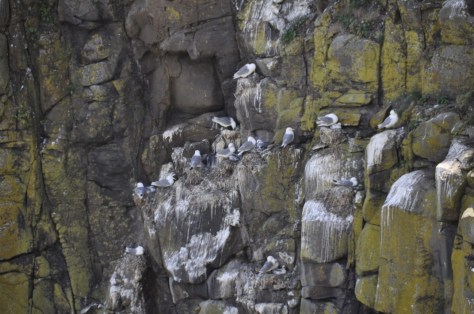
 Prudhoe Castle overlooks the River Tyne from a hill on the south bank, a little over 11 miles west of Gateshead (map).


 About 7 miles northwest from Prudhoe, as the crow flies, the fortified manor house of Aydon Castle occupies a site overlooking a small stream known as the Cor Burn (map). Its construction began in the late 13th century.
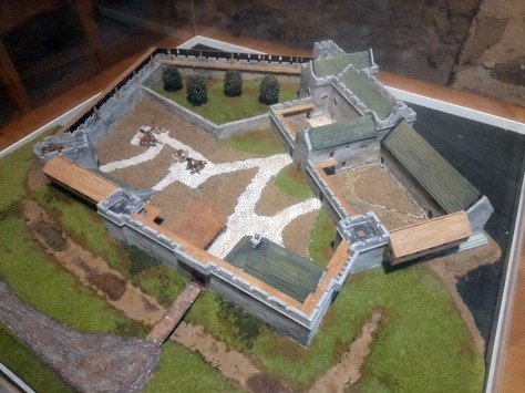
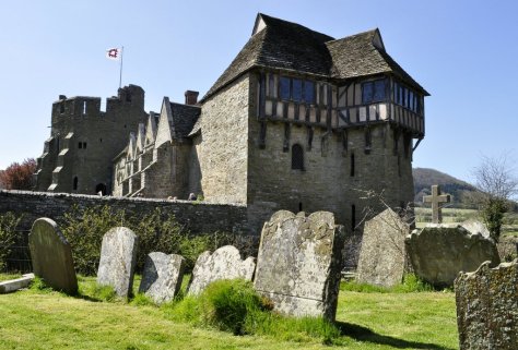


 We have visited 14th century Dunstanburgh Castle several times, but this visit less than a month ago in mid-July was the first time we had ventured this far north since moving to the northeast last October (map).


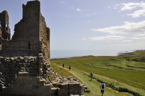
 For the past couple of months I’ve delved into Roman military fiction by British authors


 Much of our understanding of the history and archaeology of Hadrian’s Wall is down to one man in the nineteenth century:


 Chesters Roman Fort
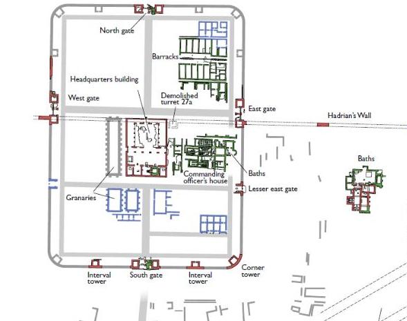


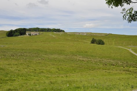

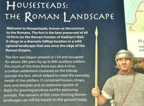 What is particularly impressive about Housesteads is its remote location. There are spectacular views from the fort over the surrounding Northumberland landscape, in all directions. And the fort and Hadrian’s Wall are intimately connected. It must have been an important site along the wall, in defence of the empire.
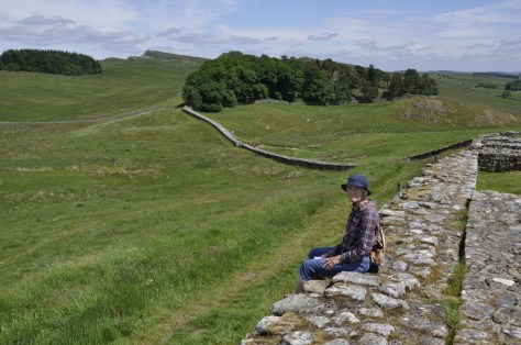
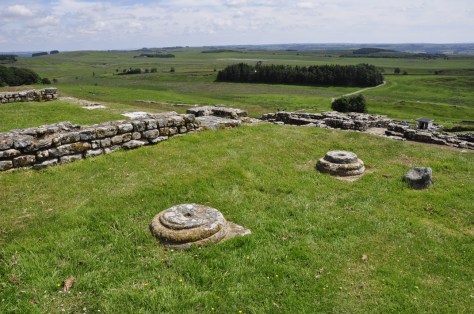


")


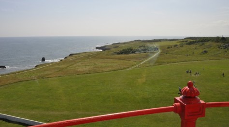


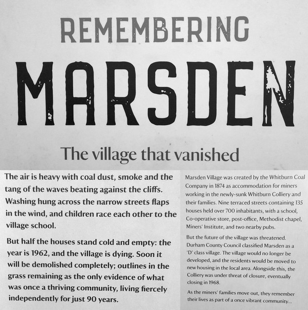
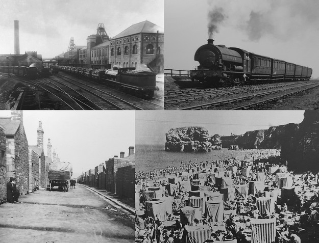
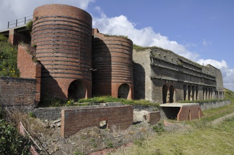

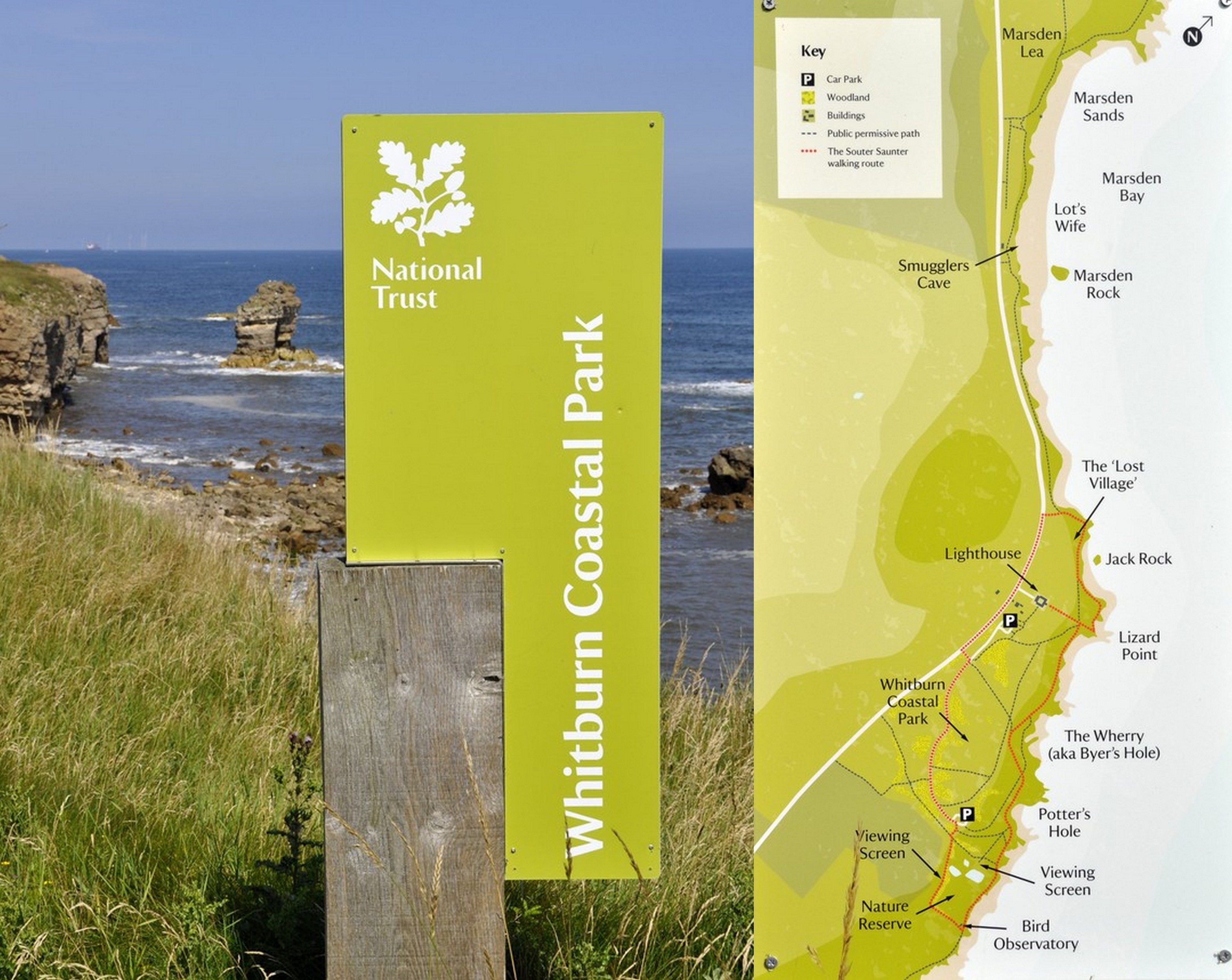


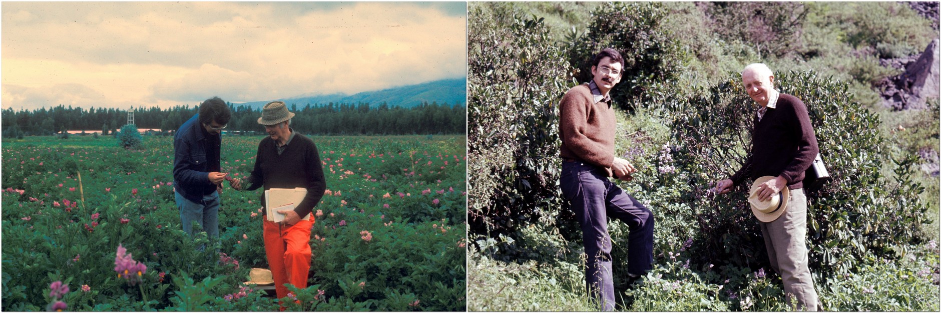


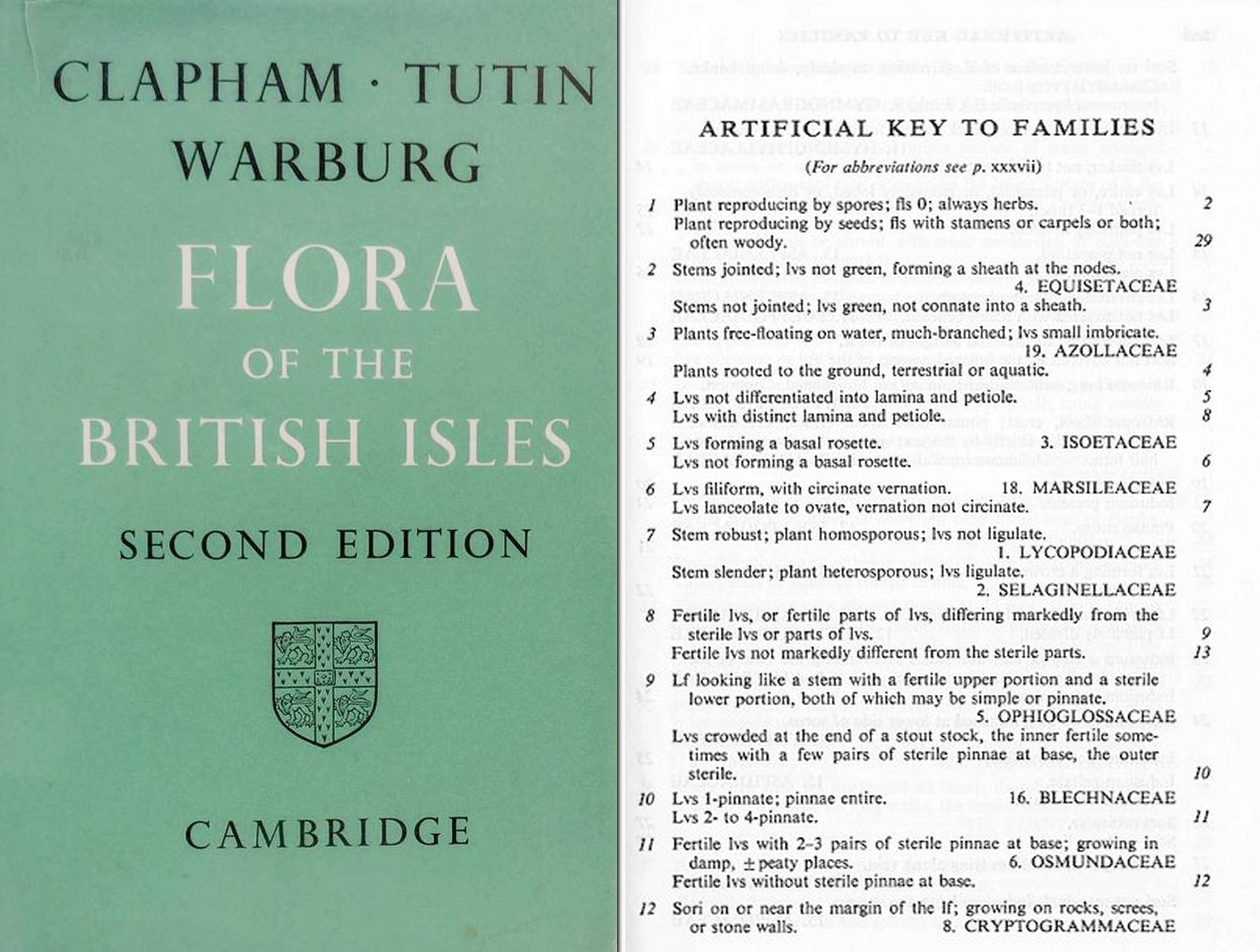
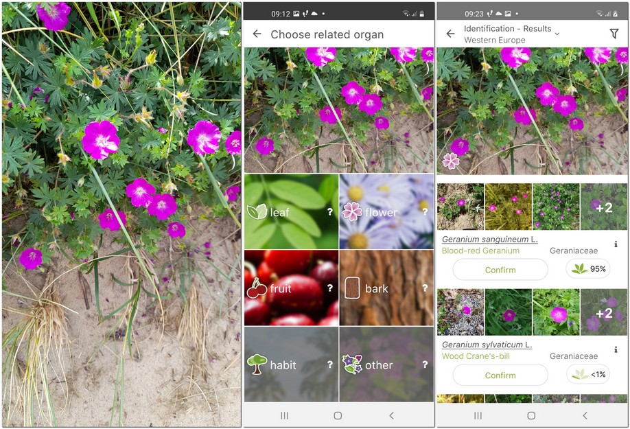
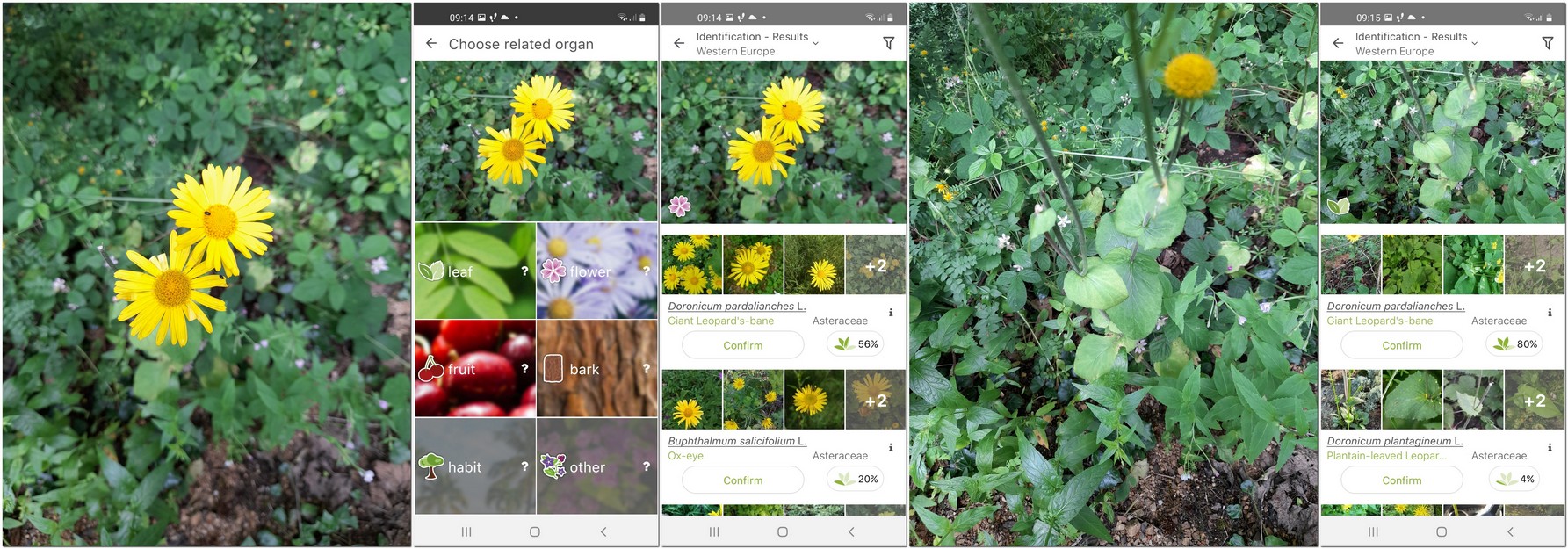
 28 June 1991. It was a Friday. Ten years and three months since I joined the University of Birmingham as a Lecturer in Plant Biology. And it was my last day in that post. A brief farewell party in the School of Biological Sciences at the end of the day, and that was it. I was no longer an academic.
 But I began to get itchy feet, and when the opportunity arose (in September 1990) for a move to the Philippines, to join the International Rice Research Institute (IRRI) as Head of the newly-established Genetic Resources Center (with its mandate to manage the world’s largest and genetically most important genebank for rice), I didn’t hesitate. Although, I have to admit, Steph and our daughters (Philippa was born in 1982) were less keen on the idea.
 Philippines with just under 24 hours to recover from my trip before the interview schedule began. In the end, I had less than four hours sleep, and was up for a 7 am breakfast meeting with Director General Klaus Lampe (right) and his three Deputy Directors General!
 I don’t remember too much about the trip from that point. Not because of over-imbibing, I hasten to add. It was just uneventful. On arrival in Manila, I was greeted by Director of Administration Tim Bertotti (right) and his Vietnamese wife who would be my ‘welcomers’ for the next few weeks, show me the IRRI ropes, so to speak, and be a couple I could turn to for advice. Having collected my heavy bags, and found the IRRI driver we headed south to Los Baños, where I stayed in the IRRI Guesthouse for the next month or so until the house allocated to me had been redecorated.

 I worked overseas for much of my career—just over 27 years—in three countries. For those who are new to my blog, I’m from the UK, and I worked in agricultural research (on potatoes and rice) in Peru, Costa Rica, and the Philippines, besides spending a decade in the UK in between teaching plant sciences at the University of Birmingham.
 I won’t deny that I have a particular soft-spot for Peru. It was a country I’d wanted to visit since I was a small boy, when I often spent hours poring over maps of South America, imagining what those distant countries and cities would be like to visit.


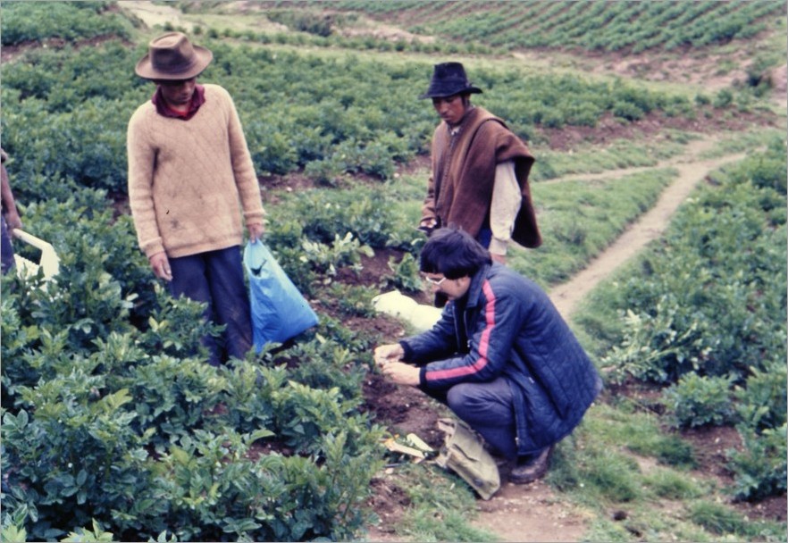


 But, after three years, it was time to move on, and that’s when we began a new chapter in Costa Rica from April 1976 a new chapter. Professionally, for me it was a significant move. I’d turned 27 a few months earlier. CIP’s Director General
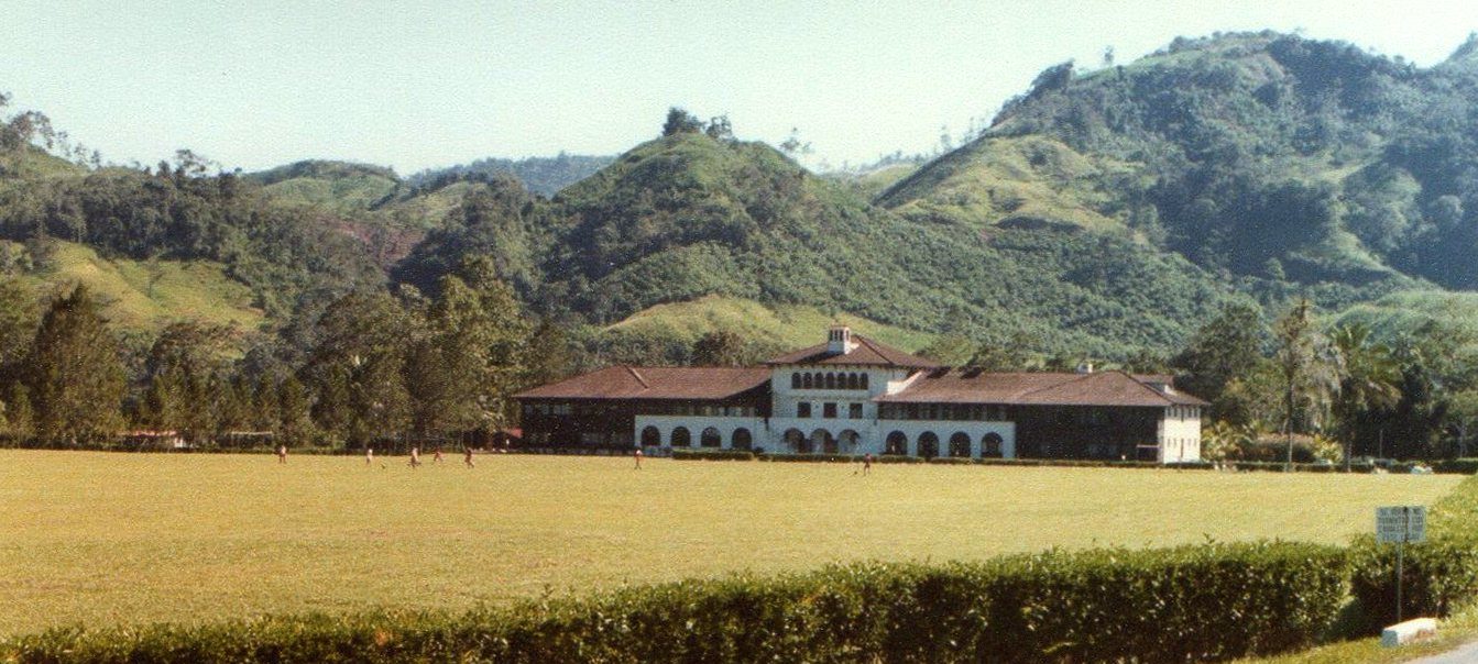
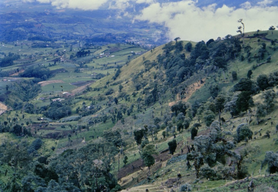

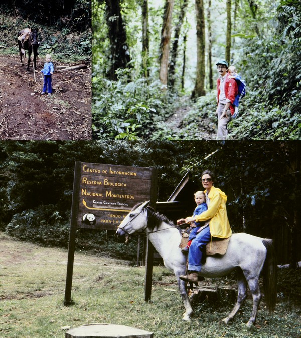


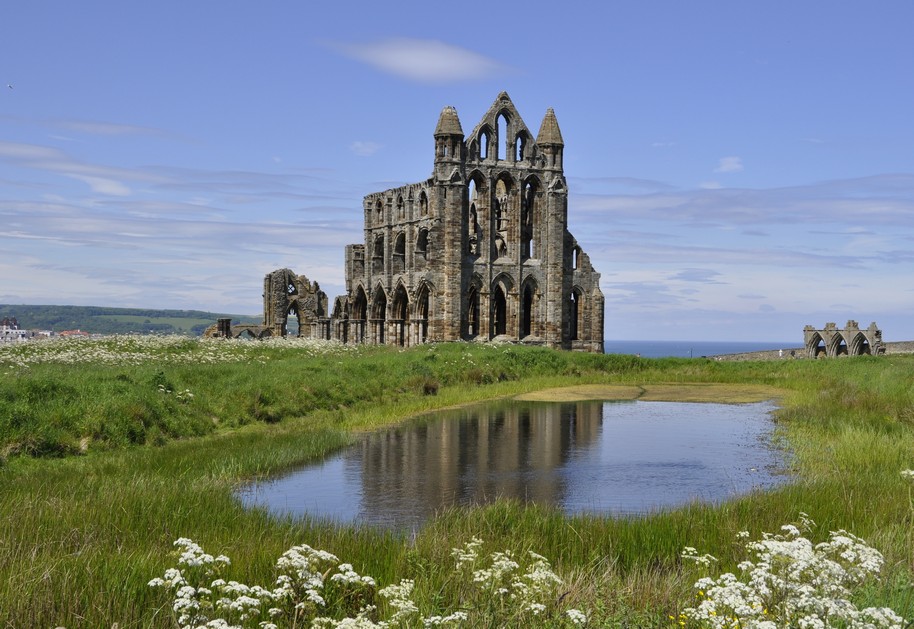
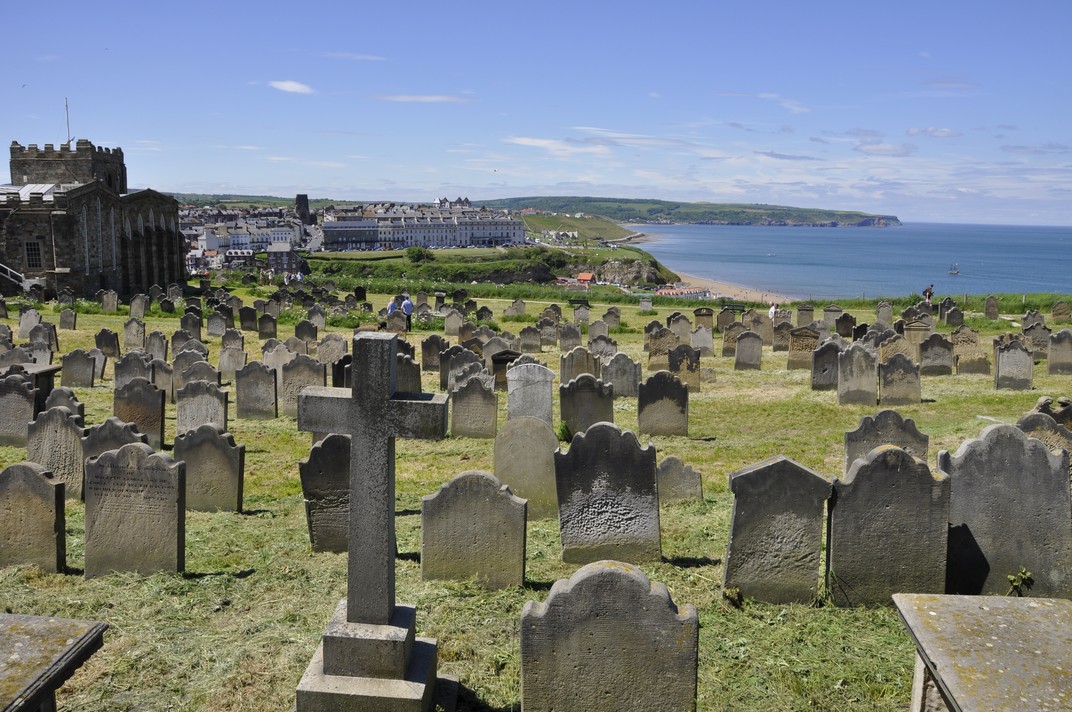


 I was never much good at taking exams. That is, until I studied for my Masters degree in Conservation and Utilization of Plant Genetic Resources at the University of Birmingham in 1970-1971. So how come I improved?


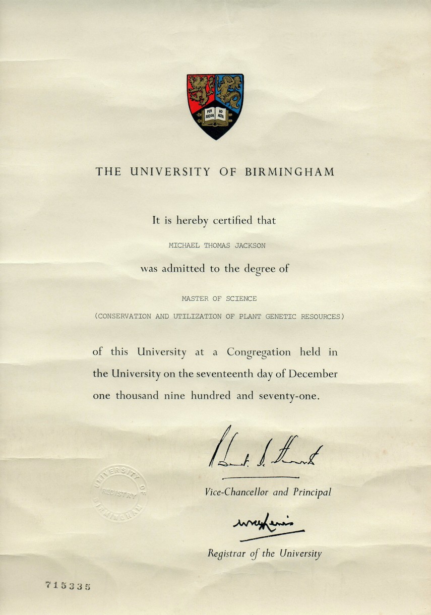
 I’m referring to
  Discovering City to City had to wait until a few weeks later when I was in San José (the capital city) to take delivery of a new car, and have a stereo system installed, including a tape deck.


 The site is owned and managed by


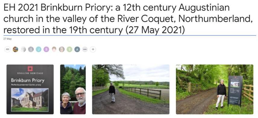


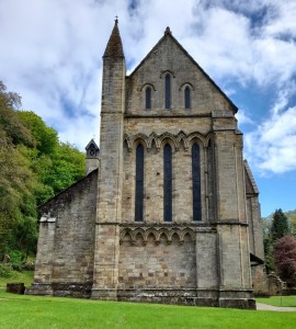 As we sat on a bench, eating a picnic lunch and facing the west end of the priory church, I couldn’t help reflecting on the other ruined monasteries and the like that we have visited over the years:
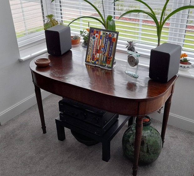

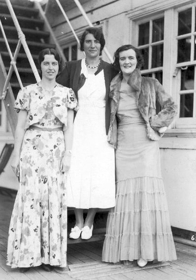

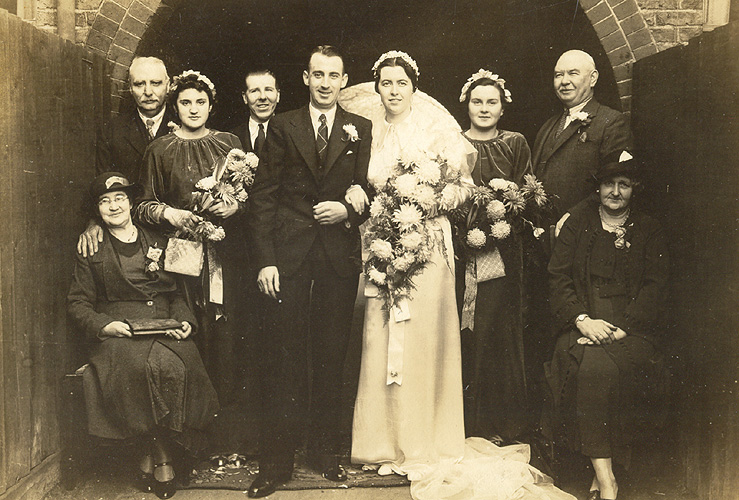
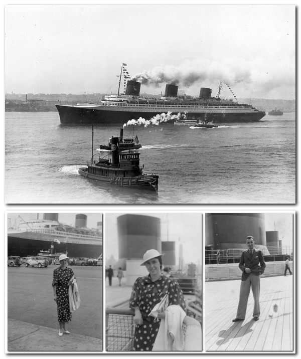


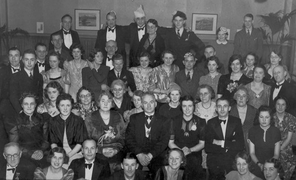


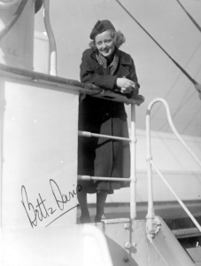
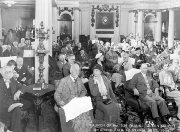
 Ask almost any scientist, and the one thing they (mostly) have in common is their dislike (I could put it stronger) of having to write reports or to be held to deadlines.


 And a couple of days ago, after seven months here in the northeast of England (on the outskirts of Newcastle upon Tyne in North Tyneside), Steph and I took our first ride on the region’s Metro. Destination: Tynemouth, just six stations and 12 minutes from our nearest station, Northumberland Park.
 Earlier last week we upgraded our concessionary travel passes (CTP) to Gold Cards. With our CTP, we have unlimited free travel on buses nationwide, one of the benefits of being a senior citizen. For an extra £12 fee, we purchased unlimited travel on the Metro that we can use everyday, but only after 09:30 on weekdays. Here’s my CTP. Somehow my image was squashed; the original I submitted with my online application was fine.


 This time, however, we had a particular Tynemouth destination in sight:


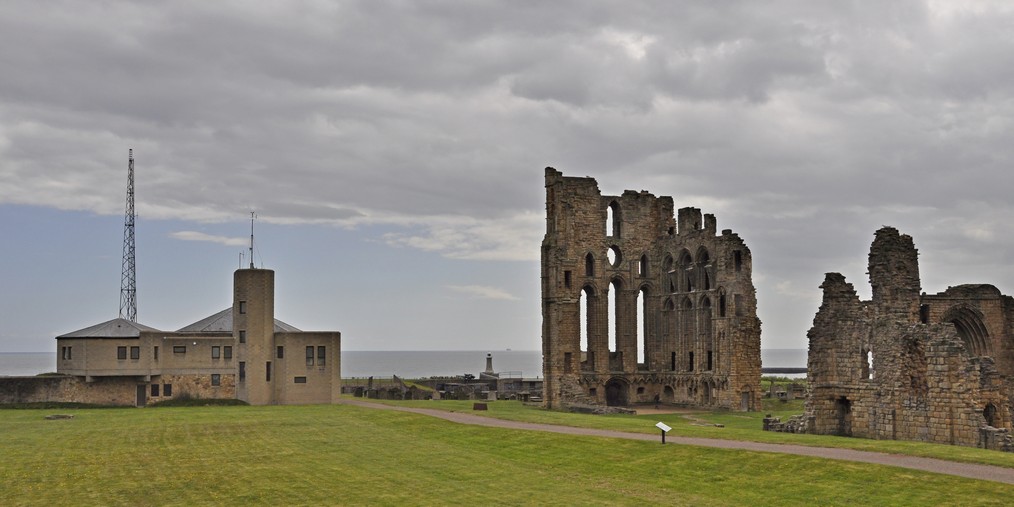


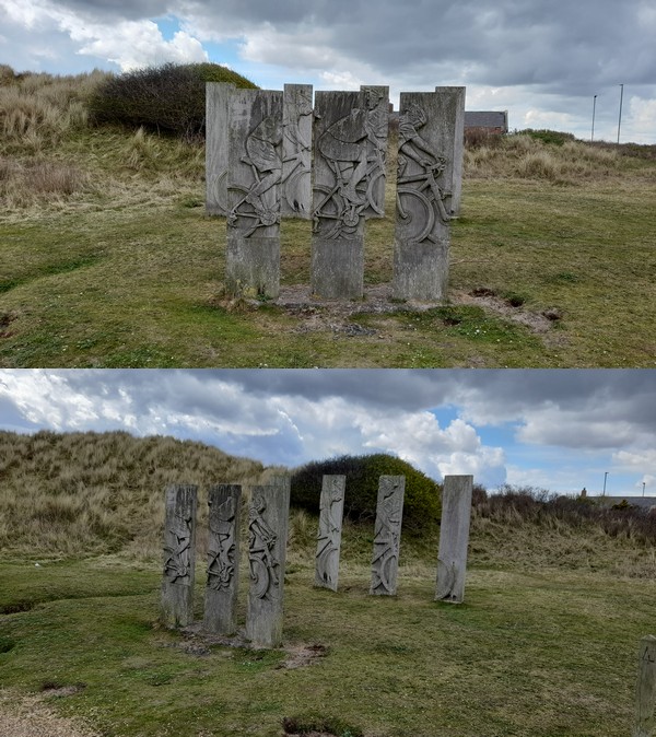

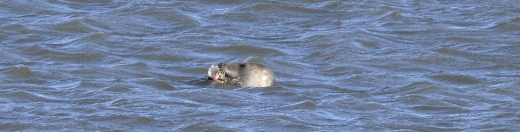


 Cherry trees are central to Japanese culture, but tastes in different varieties have changed over the centuries. ‘Taihaku’ cherries apparently went extinct in Japan in the late 19th century. Move on a few decades, and up steps a very interesting Englishman,
  In 2016, Japanese author
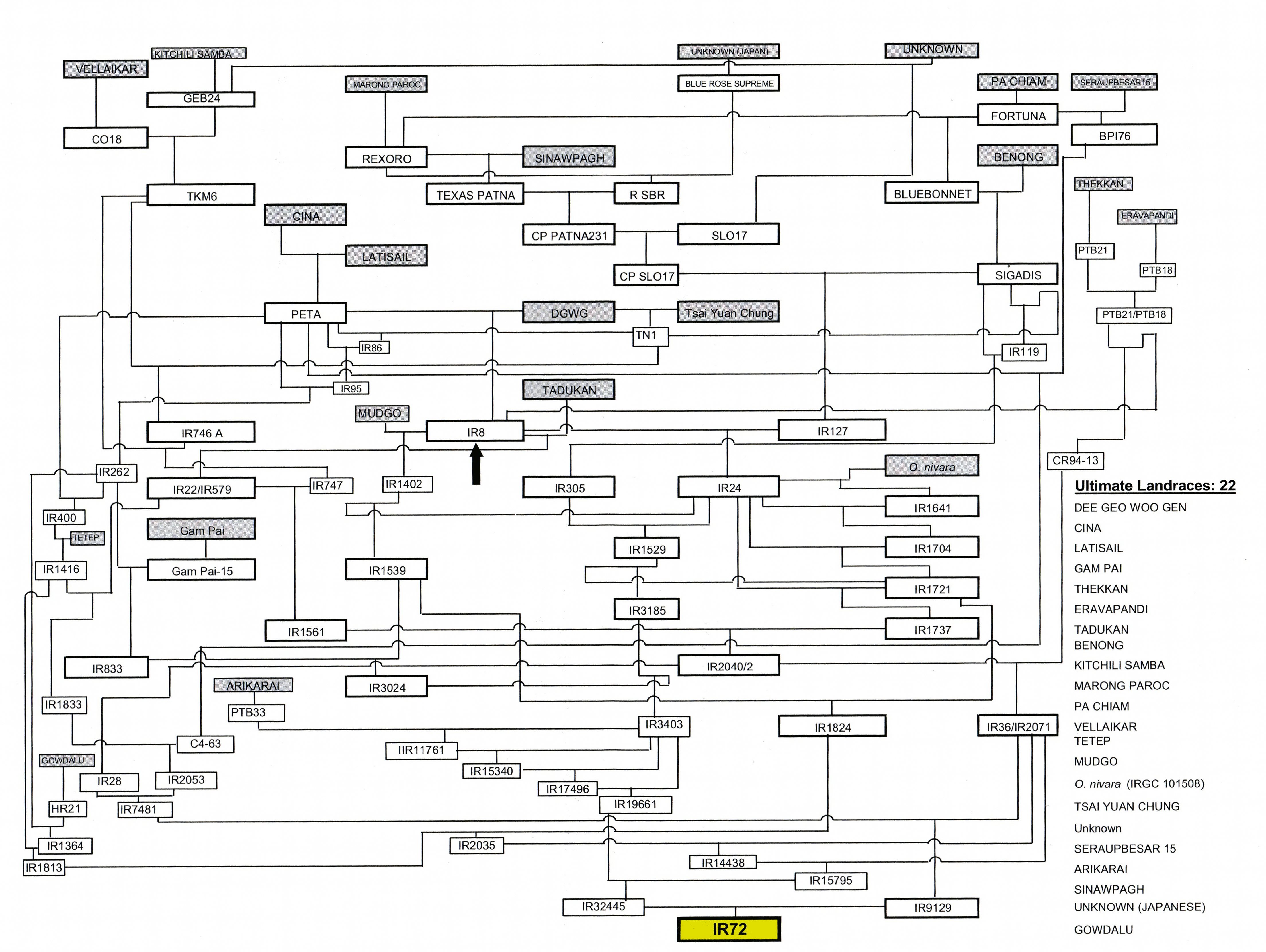
 Just recently I’ve been involved in an online discussion among old friends and colleagues about the loss of genetic diversity over the decades, and how much has actually been lost. As Brian Ford-Lloyd and I wrote in our 1986 introduction to genetic conservation:
 effort has been backstopped financially and technically by the
  Northumberland, England’s northernmost and sixth largest county, is majestic, with its rolling hills to the north, the wild moorlands in the west, and its east-facing, awe-inspiring beaches along the North Sea coast.


 This Babylonian world map, known as the
 . Mercator - The Man Who Mapped the Planet. Weidenfeld & Nicolson, London.")

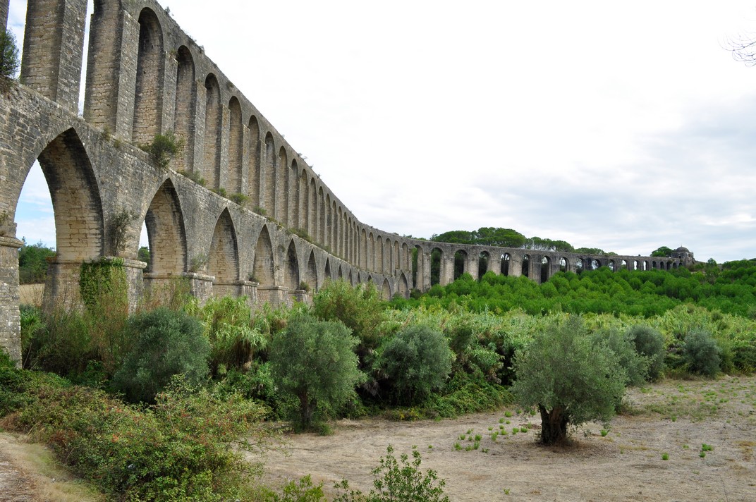


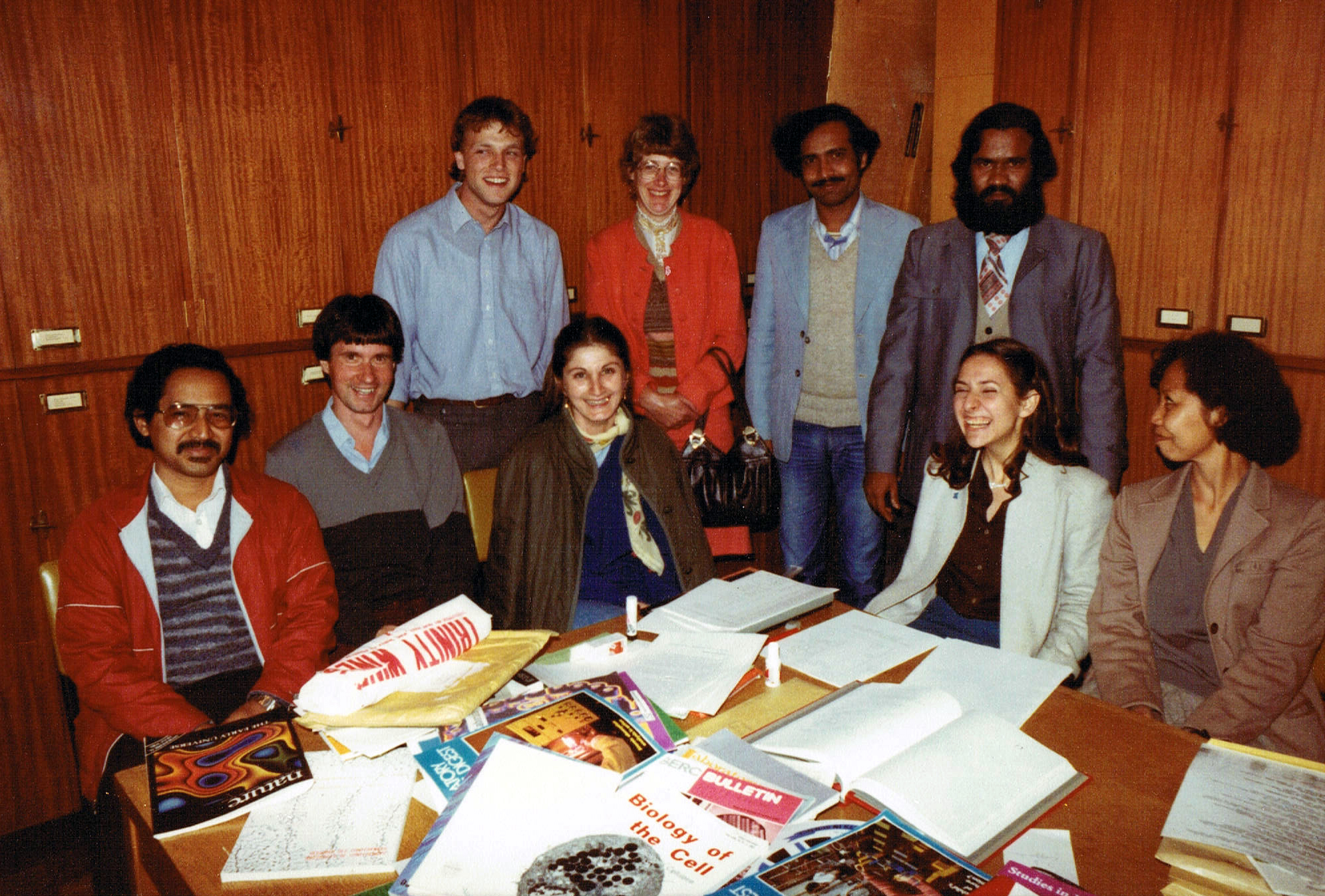

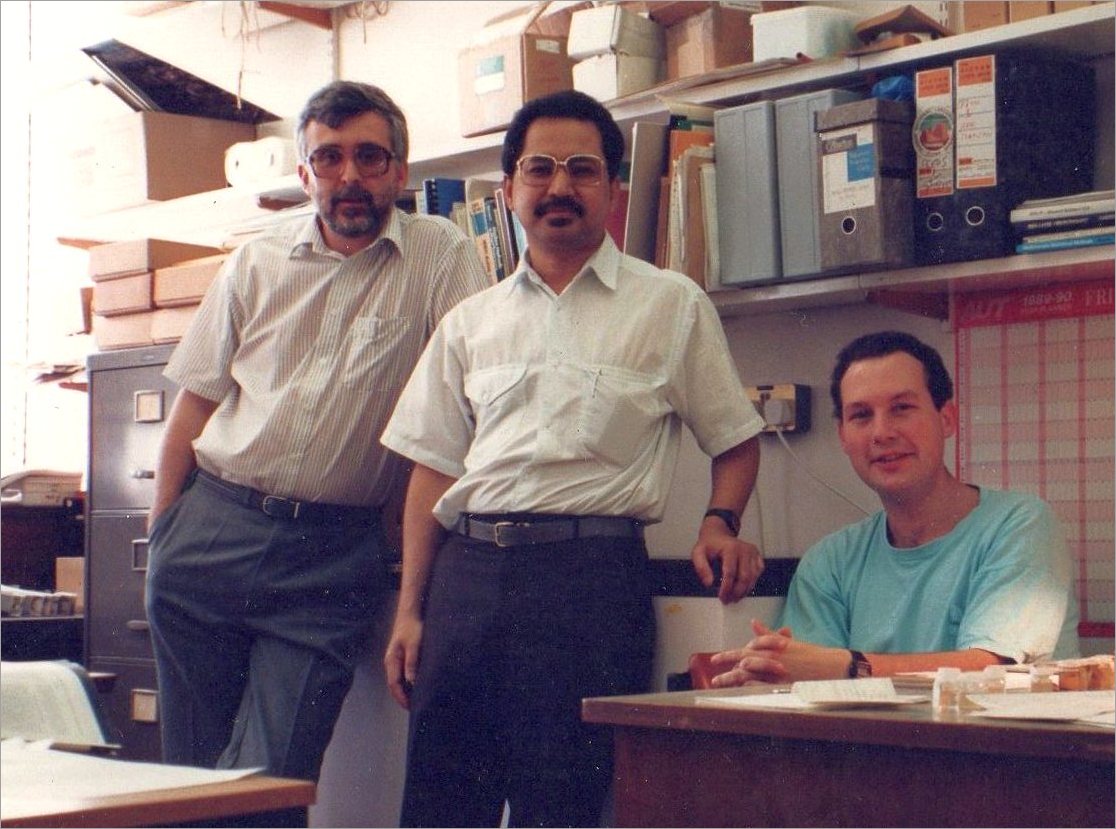
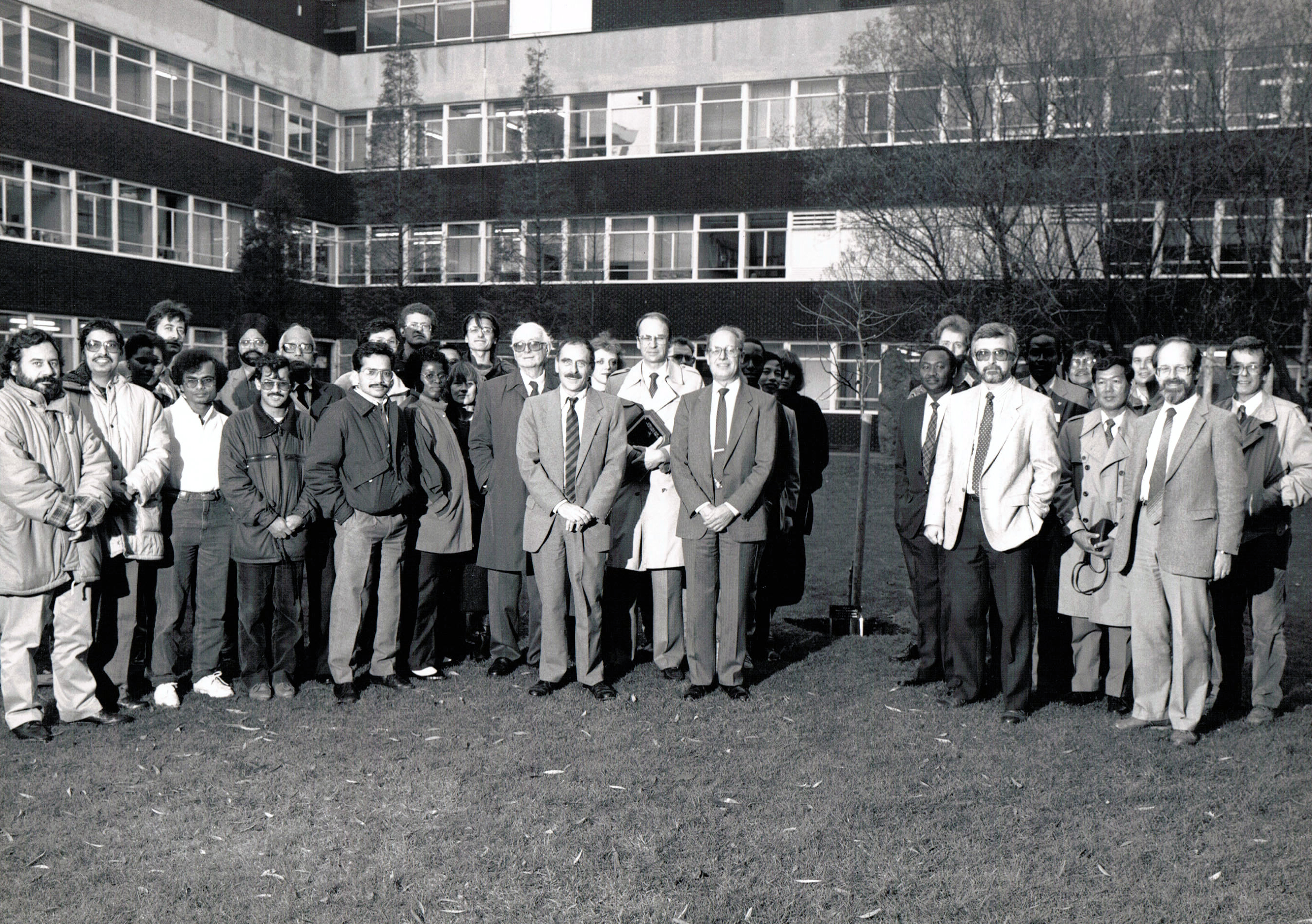

 I’m also proud of the introductory textbook on genetic resources that Brian and I wrote together, published in 1986. It quickly sold its print run of more than 3000 copies.


 [3] Jackson, M., B.V. Ford-Lloyd & M.L. Parry (eds.), 1990. Climatic Change and Plant Genetic Resources. Belhaven Press, London, p. 190.