Recently, I was asked what was the farthest I’d ever traveled. Now, if you have followed my posts here on A Balanced Diet, you will know that I have written a good deal about road trips that Steph and I made inPeru during the early 1970s, in Australia in 2003, in the USA since 2011, and around Scotland in 2015.
I’ve also written about my love-hate relationship with aviation, and some of the flights I’ve made.
So, in the context of the question I was asked, I think it has to be a trip (or several) that I’ve made over the past 50 years. And how aviation has changed during that period.
The Boeing 747 made its maiden flight on 9 February 1969 and changed aviation forever, so it’s rather sad realizing that for most airlines, the Queen of the Skies is no longer operational as a passenger aircraft. The Covid pandemic essentially killed commercial passenger travel for two years. With the introduction simultaneously of more efficient jet liners like the Boeing 777 or 787, and the Airbus A350, the 747 became, except for a handful of airlines, an aviation white elephant. Notwithstanding that Emirates Airlines has reaffirmed its commitment—for the foreseeable future—to the Super Jumbo A380.
Before 1973, when I made my first intercontinental flight, I had flown only three times: from Glasgow (GLA) to Benbecula (BEB) in the Outer Hebrides in 1966; from London Heathrow (LHR) to Glasgow in January or February 1969 to attend a folk festival at Strathclyde University; and in April 1972 to attend a conference in Izmir, Turkey flying from Birmingham International (known as Elmdon Airport back in the day) to London, and on to Izmir (IGL, now a military airbase) with Turkish Airlines via Istanbul-Yesilköy (IST, now closed to passenger flights, I believe).
Then, on 4 January 1973, I flew from London Heathrow (LHR) to Lima, Peru (LIM) with intermediate stops at Antigua (ANU) in the Caribbean, Caracas (CCS) in Venezuela, and Bogotá (BOG) in Colombia, before touching down, late at night, at a rather sultry Jorge Chávez International Airport in Lima.
This flight, just over 6500 miles, was operated by BOAC, the forerunner of British Airways, using a Boeing 707 like this one.
The Boeing 707 had a range of just over 4000 miles, and the stop in Antigua was necessary for refueling. Today, flights from Europe can easily reach Lima non-stop, and in July 2016 I flew from Amsterdam (AMS) on a Boeing 777 operated by KLM Royal Dutch Airlines, taking about 13 hours if my memory serves me right.
I first flew to Asia in the 1980s, to attend a conference in Jakarta (HLP), Indonesia from Birmingham via Amsterdam. The AMS-HLP flight, operated by KLM was a Boeing 747 (probably 300) and there must have been an intermediate layover, but I don’t remember where. There were no non-stop flights into Asia then, a distance of over 7000 miles. And since I moved to the Philippines in July 1991, and remained there until April 2012, I have flown from there all over the world. Such as the trip I made around 1994 to South Africa on Singapore Airlines: 6855 miles and almost 11 hours flying time from Singapore (SIN) to Johannesburg (JNB) across the Indian Ocean.
We stayed in the Philippines for almost 19 years, returning to the UK each year on home leave. For the first decade we traveled with KLM through Amsterdam and with intermediate stops in either Kuala Lumpur in Malaysia or Bangkok in Thailand. Then, in 2001, when Emirates began operating out of both Manila and Birmingham, we could fly home on a wide-bodied 777 with a short layover in Dubai of a couple of hours or so. The BHX-DXB flights were a little under 7 hours, and between DXB and Manila, a little over 8, with a total distance of more than 7700 miles.
It was a flight around 2005 that was my longest both in terms of miles and hours in the air. I had flown into Minneapolis-St Paul (MSP) from Manila (MNL) to spend a weekend with my elder daughter Hannah who was a graduate student at the University of Minnesota. Direct flights to the USA (via a Tokyo hub) were operated by Northwest Airlines (NWA, now Delta Airlines). And I’d expected to continue all my internal flights on NWA. However there was a major strike and I had to scrabble around to find alternative flights on other airlines that would accept my NWA ticket. Eventually all was sorted, and the trip went ahead without any other hitches.
After my last stop in New York, I flew from New York-La Guardia (LGA) to Chicago O’Hare (ORD) to connect with a United flight to Hong Kong-Kai Tak (HKG), with yet another connection on Canadian Pacific to Manila.
My intercontinental flights on NWA had been booked in Business Class (First on US domestic flights). United honored these tickets, and I was upgraded to First on the ORD-HKG flight, much to my relief. I knew it would be a long haul, but hadn’t appreciated just how long. Just under 7800 miles, and 17½ hours.
It was a 747-400, and every seat was taken. We were heavy! In fact, as we taxied out for take-off, our captain advised us there was a better than even chance that we would have to make a stop in Beijing to refuel given the anticipated headwinds. I can remember willing that aircraft into the air; what a long roll before rotation. As it transpired we didn’t have to land in Beijing, but the final couple of hours we must have been flying on vapor, or gliding into Hong Kong. The total trip was just under 9300 miles.
However, the longest trip of all was from BHX to Melbourne (MEL), Australia via Dubai (DXB) on Emirates Airlines (EK) in November 2016 when I had to attend a 3-day meeting of a genebank program I was reviewing.
I was joined by my good friend and former colleague Professor Brian Ford-Lloyd. We met up in the Emirates lounge at BHX before setting off to DXB on a Boeing 777-300 ER, and connecting, after a layover of an hour or so, with an A380 flight to MEL.
Brian and me enjoying a wee dram on one of our A380 flights.
The flight to DXB took about 7 hours, a distance of 3500 miles. The connecting flight was 7200 miles and about 14½ hours. The return flights were slightly longer due to headwinds.
In total then this trip to Australia was the farthest I’ve traveled: more than 21 hours flying time, and around 10,700 miles.
York is an historic town, founded by the Romans in AD 71 and known as Eboracum. It was one of the most important settlements in Roman Britannia, sitting at the confluence of the rivers Ouse and Foss, and navigable inland from the North Sea.
Just over 80 miles south of our home in North Tyneside, we enjoyed an excursion to York last week.
From the magnificent York Minster (completed after several centuries in 1472) to the city walls dating mainly to the 13th century (but built on earlier earth banks), and the bustling and narrow streets of the medieval town around Shambles, York has a lot to offer any tourist. And even in the middle of September after children had begun the school year, the city center was extremely busy with visitors from the four corners of the world (if the languages I heard spoken were anything to go by).
While we appreciated the Minster from outside, walked through Shambles, and enjoyed a section of the city walls circuit west of the River Ouse (from Baile Hill, past Micklegate Bar, and back to the Ouse) we had traveled to York to visit the Treasurer’s House (a National Trust property behind the Minster), and Clifford’s Tower (an English Heritage property near the confluence of the two rivers, with a magnificent 360º view over the city). More images of York can be viewed here.
The journey south, on just the A19 the whole way, took around 90 minutes. Just outside York we parked at Rawcliffe Bar Park and Ride on the northwest of the city before 10:30, and took the bus into Museum Street close-by the Minster, and a 15 minute journey costing just £1.20 return (with our concessionary travel cards).
The Treasurer’s House sits just behind York Minster (off Minster Yard) and was the residence of its Treasurer (a position established in 1091) until 1547 when it was abolished during the Reformation.
The Grade 1 listed house we see today, from the early 17th century, was previously much larger comprising several additional wings that are now part of Grays Court hotel. Roman remains have been found beneath the house.
In the fading years of the 19th century, Treasurer’s House was bought by eccentric industrialist Frank Green (born 1861, right), who filled it with exquisite paintings, ceramics, and furniture. So none of the interior is contemporary to the house per se, rather a reflection of Green’s eclectic collecting passion.
The family wealth was founded by Green’s grandfather Edward, who established the an engineering firm in Wakefield in 1821. Edward Green patented (in 1845) a design—Green’s Economizer—to increase the steam-raising efficiency of boilers. The company is still in operation today.
Frank’s father, Sir Edward Green was Conservative MP for Wakefield from 1895 to 1892. He married Mary Lycett, introducing that surname into the family although it was not used by Frank but by his elder brother Edward who became the second baronet. Edward Lycett Green, 2nd Baronet took no interest in the engineering company.
L-R: Edward Green (grandfather), Sir Edward Green, and Mary Lycett (parents)
Frank Green never married. He was an irascible individual, obsessed by cleanliness and hygiene. Even down to the placement of furniture in the house, marking precisely where each piece should be replaced if it was ever moved for cleaning. And woe-betide any of staff who didn’t follow his instructions – to the letter! He even sent his laundry each week to London for cleaning. Nevertheless, he was, by all accounts, a genial host of York society, celebrities, even royalty.
He extensively remodeled the house, and opened the central part to create a great hall – because he thought all ‘good’ houses needed a hall (and a gallery). The magnificent staircase to the first floor was a purchase from another house, and none of the paintings displayed there have any connection with the house whatsoever.
Entrance hall.
Dining room ceiling.
Wedgwood cauliflower teapot.
Plaques on the wall of the great hall.
The great hall and gallery.S
Sitting room.
Staircase.
Queen’s bedroom.
King’s bedroom.
A full album of images from our visit can be found here.
By 1930, and his health declining (perhaps because of the damp conditions in York), Frank Green moved away from the Treasurer’s House and set up home in Somerset. He gave the Treasurer’s House and all its contents to the National Trust which has faithfully looked after the property ever since. Even making sure that the furniture is always replaced on the marks on the floor! He is also reputed to have left one of his Rolls Royce limousines to his chauffeur who set up a taxi business. In Somerset, Green was instrumental in saving the Exmoor pony breed during World War II.
Clifford’s Tower stands atop a very steep mound – the motte, and until recently visitors could only enter and gaze up at the blank walls. That is until English Heritage constructed a framework inside that takes visitors on to the roof and affording those panoramic views over the city.
This Norman tower was built on the orders of William I (the Conqueror) in 1068, and rebuilt a year later after it was destroyed by Vikings.
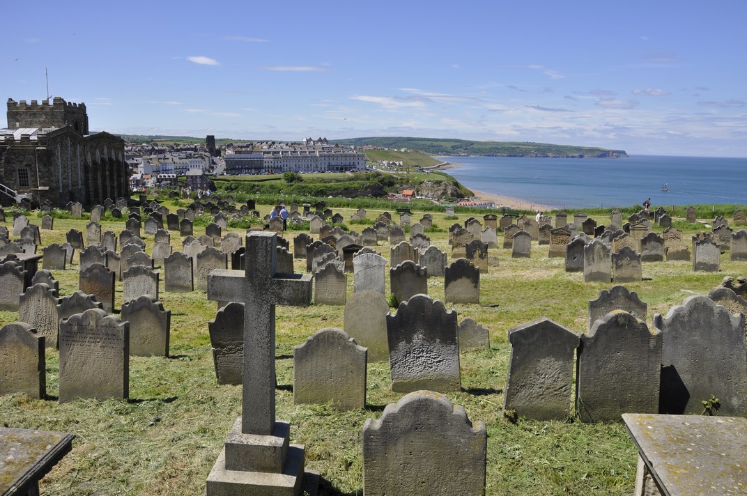
York or Jórvík had been the Scandinavian capital in northern England. In 1190 the Jews of York died in a pogrom inside the tower.
By the 18th century the tower was being used as a gaol and continued as such until the 1890s. Across the River Ouse the remains of York’s second castle can be seen at Baille Hill alongside the city walls.
By the time we had walked that section of the wall, it must have been 15:30 and catching the bus in Museum Street back to Rawcliffe Bar we were on the road home by 16:00, arriving around 17:20. York is a fascinating city and has lots to offer, and we’ll have to make plans to return again.
Lasting for over 1000 years, from the time of the first Emperor Augustus (Gaius Julius Octavius, 63 BC – AD 14) in 27 BC, its physical legacy can be seen all over Europe, North Africa, and the Middle East.
Julius Caesar
Eventually Britain (Britannia) came under the sway of the Romans. In 55 BC, Gaius Julius Caesar (100-44 BC) led an expeditionary force to this island, returning the following year. But that did not lead to conquest, taking almost another 100 years to complete, under the Emperor Claudius (Tiberius Claudius Drusus Nero Germanicus, 10 BC – AD 54) in AD 43.
What is remarkable in many ways, is that the Roman occupation of Britannia lasted less than 400 years. By AD 410 they had upped sticks and departed.
Less than 60 years after the conquest of Britannia, the Romans built a road network of almost 8000 miles, and in AD 122, the Emperor Hadrian (Publius Aelius Hadrianus, AD 76-138) ordered the construction of a wall across the narrowest part of northern England, from the Solway Firth in the west to the North Sea coast in the east.
Twenty years later, under the Emperor Antoninus Pius (Titus Aurelius Fulvus Boionus Arrius Antoninus, AD 86-161), the Antonine Wall was constructed from turf on a stone foundation, coast to coast, about 40 miles north from Hadrian’s Wall in Scotland. It was abandoned less than 10 years later.
Location of Hadrian’s Wall and the Antonine Wall
Hadrian’s Wall is surely one of the most conspicuous of all Roman remains, anywhere. It still stands proudly, although somewhat diminished, where once it guarded the most northwestern frontier of the empire against barbarians to the north. It was a remarkable achievement, and even today inspires wonder at the effort it took to construct the Wall over the wildest of landscapes.
And we can also wonder about the lives of the men (and women) who were stationed along the Wall and where they came from. It’s not just the physical legacy of the Wall (and other settlements around the country) but also the genetic legacy that the Romans left behind, in their offspring from relationships with local women, legitimate or otherwise. Romans didn’t just come from Rome, but from all corners of the empire even from the easternmost provinces of the Middle East and beyond. The ‘Roman’ genetic signature has obviously been diluted by successive waves of invasion into these islands.
The Romans have left a huge legacy for us all to wonder at. They were road builders par excellence. Roads were needed as the Romans spread out across the country, to maintain communications between towns and military garrisons, to allow troops to travel more effectively and rapidly, and to facilitate commerce. And their roads have endured even today, and some of England’s principal arteries follow the routes of former Roman roads, and are known, in part, by the same names.
I recently came across this stylized map (in the format of the iconic map of the London Underground created by Harry Beck) of the Roman road network that connected towns and cities, and military installations all over.
Even today, Roman roads are still being uncovered. There was a report recently in The Guardian of a road in west Wales that indicated the Romans had ventured deeper into Wales than previously appreciated.
As far as I can recall, the only Roman road I have walked was the Wheeldale Roman road on the North York Moors near Goathland. The exposed part is only about a mile long. The first time was in 1968 when I was at university, and then about 20 years later with my wife Steph and daughters Hannah and Philippa.
We now live in North Tyneside, just 3 miles north as the crow flies from Segedunum, the fort at the the eastern end of Hadrian’s Wall. And with Hadrian’s Wall and other Roman remains so close, we have made quite a number of forays into the Northumberland countryside to explore them.
It’s quite remarkable just how much of Hadrian’s Wall remains, after 2000 years, despite much of the stone having been removed.
Hadrian’s Wall at Sycamore Gap.
The Wall was much higher than remains today, and the Mileposts and Turrets (or observation towers) have been reduced to shells of their former imposing structures.
Milepost 39 near Sycamore Gap.
However, further west beyond Birdoswald, where the Wall was built from turf, the signature of the Wall can still be seen as depressions in the landscape.
Underfloor heating at Chester’s Roman Fort (English Heritage)
Housesteads from the air (Source: English Heritage)
East Gate at Birdoswald Roman Fort
Grain stores at Corbridge Roman Town, National Trust
Vindolanda
Archaeology at Vindolanda
This is a panorama across Corbridge Roman Town.
At Wroxeter, in Shropshire, one part of a basilica wall still stands, and at Portchester the impressive outer curtain wall of the original Roman fort is still intact, 20 feet or more tall. Typical Roman concrete, just like I have seen in Rome itself.
The surviving 7 m high basilica wall (‘Old Work’) at Wroxeter, the largest free-standing wall in England.
The Roman walls of Portschester Castle.
And then there are the civil remains like Fishbourne Roman Palace near Chichester in West Sussex (that I haven’t visited) and Chedworth Roman Villa in Gloucestershire that we have.
And Roman remains are still being uncovered all over England. Not only hoards of coins, but also a beautiful mosaic that was discovered in a farmer’s field in eastern England a couple of years ago, with images of Homer’s Iliad, a unique find. Roman archaeology is thriving.
Then there are all the various artefacts, from jewelry to household items, monuments and statues that were left behind that allow us to paint a detailed picture of life in Roman Britain. Here are some kept in the museums at Corbridge Roman Town and Chesters Roman Fort.
And, in particular, the Vindolanda Tablets, the oldest surviving handwritten documents in this country, have provided a commentary of the lives of soldiers and their families.
The world-famous Vindolanda Tablets
These are some of the most important relics from the period of Roman occupation. And these, and other sites and remains from that time will keep archaeologists busy for years to come.
The vandalism began in 1536. The landscape changed. Henry VIII threw his toys out of the pram, and ordered his officials to close down religious houses all over England, in what has become known as The Dissolution of the Monasteries. What had been thriving communities, with some of the most magnificent architecture that this country has ever produced, were sold off, some converted where possible into residences, or simply destroyed.
And much of Henry’s despotic legacy still stands in ruins in many parts of England 500 years later.
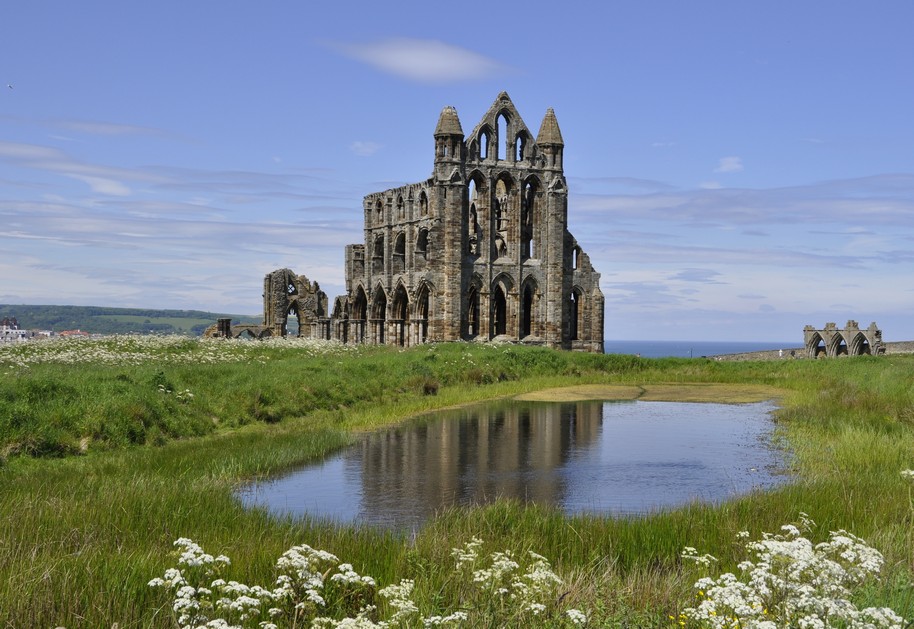
Over the past 12 years, we have (as members of the National Trust and English Heritage) visited many of the ruins of once proud, the grand (like Fountains, Rievaulx, and Whitby in North Yorkshire) and not-so-grand monasteries, priories, abbeys, and the like, as well as some small churches and chapels (Langley in Shropshire, St Mary’s at Kempley in Gloucestershire with its magnificent frescoes, or the ancient church of St Clement’s on the southern tip of Harris in the Outer Hebrides) that did survive and continue to serve their communities, some dating back to pre-Norman Saxon times.
Fountains Abbey
Rievaulx Abbey
Whitby Abbey
Langley Chapel, Shropshire
Six of the 12 apostles on the north wall of the chancel., St Mary’s Kempley
St Clement’s, Rodel, Isle of Harris
Some we made a bee-line for; others we came across quite by chance. All have been inspirational in one way or another, although I should add that I hold no religious beliefs. I am inspired nevertheless by these buildings and how they must have dominated the surrounding landscape during their brief ‘lives’. Many were built in the couple of centuries after the Norman conquest of England in 1066. And I am inspired by the skills of the masons and other craftsmen who created these magnificent buildings.
Just click on any of the icons on the map below to view links to my stories or to photo albums. I’ve also included links to National Trust or English Heritage web pages where available. To open the map in full screen mode in a new tab, click on square icon in the top right hand corner.
One thing you can say, however, is that these religious orders certainly knew where to found their abbeys, monasteries, or priories. Just a few days ago, Steph and I made the short (<18 mile) journey south into County Durham to visit Finchale Priory that stands beside a bend in the River Wear. What a peaceful setting, and you can easily image just how that tranquility made for easy religious contemplation. Something of that spirituality lingers. Quite magic!
Twice a day—without fail—the Holy Island of Lindisfarne, lying about 1 mile at its closest point off the north coast of Northumberland (map), is separated from the mainland as the tide sweeps in and covers a paved causeway.
The tide takes no prisoners, but safe crossing times are widely publicized. Not everyone heeds those warnings.
Steph and I last visited Holy Island (for the first and only time) in July 1998 when we were on home leave from the Philippines.
Earlier this week, we headed north to visit the two attractions on Holy Island: Lindisfarne Priory (run by English Heritage, which we looked at in 1998), and Lindisfarne Castle (managed by the National Trust). It’s quite unusual to have separate attractions from these two organizations at the same location (although they do co-manage several properties around the country).
My satnav indicated a journey of about 58 miles to the village, just 54 to the start of the causeway, and about an hour’s travel time. So we left home around 09:45 with the aim of arriving at the causeway just as the tide had receded. The causeway was already open when we arrived, ahead of the published safe crossing time of 10:55. There were already many vehicles in the car park.
There is only a small population of around 160 persons on the island. But that number is swelled to at least 650,000 or more visitors a year. Choosing a day for our visit, we were just waiting for the tide times and good weather to coincide. As it transpired, the day was not as bright as originally forecast, but that was no bad thing. Sometimes photography is much easier when the light is even; no harsh shadows. Even so, we only saw the sun as we were preparing to leave late in the afternoon.
The history of Lindisfarne Priory is illustrious and tragic. It was founded in the 7th century, on a promontory at the southwest corner of the island, and is one of the most important early Christian sites in the country. An Irish monk named Aidan became the bishop of Oswald’s Kingdom of Northumbria, and founded the Priory on Holy Island.
12th century wall paining of St Cuthbert in Durham Cathedral.
One of the North’s greatest saints, Cuthbert (who is buried in Durham Cathedral) joined the community in the 670s as monk-bishop.
However, in AD 793, Lindisfarne was raided for the first time by the Vikings, and over the next century the Priory declined under the threat of further raids, with as few as a couple of monks at one time.
After the Norman Conquest of England in AD 1066, Lindisfarne was re-founded and continued to thrive albeit at a low level. In the 13th century, after Edward I’s invasion of Scotland, border warfare flared, and the monks were obliged to fortify their Priory.
Then along came Henry VIII, and in 1537, the Priory was ordered to close. By the 18th century much of the priory lay in ruins, although the church was reported as more or less intact in 1780. Further collapses followed in the subsequent decades.
Click on the image (right) to open a site plan of the Priory on the English Heritage website.
I think one of the first impressions of the Priory is the rich red color of much of the stonework, of the West Front and what remains of the church. Particularly striking is the so-called ‘rainbow’ arch, the surviving rib of a crossing vault even though the tower above it has collapsed.
Here is a small selection of the many photos I took in the Priory; there are more in this album.
I shouldn’t finish this brief description of Lindisfarne Priory without mentioning the Lindisfarne Gospels, one of the most spectacular manuscripts to have survived from Anglo-Saxon England, and now residing in the British Library. There is a small exhibit about the gospels in the Church of St Mary the Virgin adjoining the ruins of the Priory.
From the grounds of the Priory there are stunning views towards Lindisfarne Castle that sits on a rocky crag at the southeast corner of the island.
And having seen all there was to see in the Priory, that’s where we were headed, a walk of a little over a mile from the village.
A fort or castle has stood here since Tudor times in the 16th century after the Dissolution of the Monasteries and Lindisfarne Priory was abandoned.
Stone from the Priory was used in the construction of the castle, which stands on a rocky outcrop known as Beblowe Crag. The walls are very thick, since several rooms were used as powder magazines.
In 1901, the castle was purchased by Edward Hudson (owner of Country Life magazine) who commissioned the famous architect Sir Edwin Lutyens (who played a leading role in the design and building of New Delhi as the capital of India) to refurbish the castle in the Arts and Craft style. The castle was given to the National Trust in 1944 and opened to the public in the late 1960s.
Access to the castle is up a winding and quite steep slope, through a sturdy wooden door (with the remains of a portcullis) and up a flight of stairs to the entrance terrace. Just a few rooms are open to the public (the entrance hall, kitchen/parlor, the dining room and a couple of bedrooms. But there is also access to an upper terrace and I guess many visitors to the castle come for the stunning views from there over Holy Island, and north and south on the mainland coast with views of Bamburgh Castle also due south.
Here are a few of the photos I took on that visit. Others can be seen in this album.
Lindisfarne Priory from the castle.
Bamburgh Castle from Lindisfarne.
To the north of the castle is a small walled garden, designed in 1911 by the influential garden designer and horticulturist, Gertrude Jeckyll(1843-1932).
Further east from the castle crag, there is a set of lime kilns built in the 1860s. Limestone was quarried on the north of the island; coal was brought in by sea.
It was a slow walk back to car park. Having enjoyed an interesting visit to Holy Island, it was time to head south for home. We left just after 15:30, well ahead of the closure of the causeway on the incoming tide.
We really must return, in the winter (weather permitting) when there are fewer visitors (it really was quite hectic throughout), but also when the geese return. Lindisfarne is an important wildlife area.
A baker’s dozen¹. That’s how many National Trust (NT) and English Heritage (EH) properties—spanning more than 4500 years of history—Steph and I visited recently during the course of a 10-day and 1337 mile holiday in the south of England. We stayed at a cottage in the New Forest, near the village of Beaulieu in Hampshire, almost 300 miles due south (as the crow flies) from where we live in North Tyneside, near Newcastle upon Tyne in the northeast of England, but almost 380 miles by road.
At the end of this piece I’ll also tell you all about that extraordinary close encounter that occurred on the last day.
We took two days each way, stopping off in Banbury, Oxfordshire on the way south, and Leek, in North Staffordshire (and my ‘home town’) returning north. And on each of these four days we visited one NT or EH property, and the other nine during six days in Hampshire. The round trip took in 19 non-metropolitan and metropolitan counties². And over the course of our break we managed to walk, on average, more than four miles each day.
Click on the map below to view the NT and EH icons for each of the 13 properties.
In this post I’ve made little attempt to provide a comprehensive description of each property. Rather I have selected a few highlights that caught my attention. But there are links to National Trust or English Heritage and other sites for each property where you can find much more detail. I have however included links to the photo albums I have created to display the many photos I took during this trip.
Nostell (photo album)
Looking for somewhere to visit, about half the distant to Banbury on the first day, I came across Nostell in the National Trust handbook. Located in West Yorkshire, a few miles south of the M62 (roughly between and south of Wakefield and Pontefract) it was a convenient spot to break our journey after 110 miles on the road.
And we weren’t disappointed.
Dating from the 1730s, it was built, in Palladian style, for the Winn family who continued to live there until the property and contents were given to the National Trust in 1953.
Nostell is renowned for several treasures: an impressive doll’s house made for Susanna Winn and her sister in the 1730s; a fine collection of oil paintings including one by Pieter Brueghel the Younger, and a copy of a Holbein of the family of Sir Thomas Moore; and perhaps one of the finest collections of furniture designed and made by Thomas Chippendale.
The Nostell collection also includes a wooden clock, made in 1717, by John Harrison, the clock-making genius who made the world’s first marine chronometer.
We enjoyed a walk through the park (which covers more than 300 acres), around the lake and in the walled garden which had a stunning display of tulips.
Leaving Nostell by mid-afternoon, we headed south on the M1, M42, and M40 motorways to arrive at our Premier Inn for the night in Banbury, a distance of 142 miles.
Basildon Park (photo album)
After a satisfying Premier Inn full English breakfast (highly recommended!), we set off south again, covering the 53 miles in under 1½ hours, and crossing the lovely landscape of the Berkshire Downs close to Basildon Park which overlooks the River Thames near Pangbourne, west of Reading.
Basildon Park has had an interesting history. Built in the Palladian style and decorated inside by Robert Adam, between 1776 and 1783, it served as a convalescent hospital during WW1, a barracks for a US airborne division in WW2, and fell into disrepair thereafter. It was rescued by Lord and Lady Iliffe, who gave the property and estate to the National Trust in 1978.
Among the most impressive are the dining room, the octagonal room, and the extraordinary shell room. Much of the house has a homely feel, and apparently the Iliffe’s stipulated that each room should be displayed as though the family were still living there.
We also enjoyed a walk around the park of almost 5 miles, and came across the most wonderful display of bluebells I think I have ever seen. Unfortunately, the disease ‘ash dieback‘ has taken hold quite seriously across the estate.
Then we headed back to the A34 and south to the New Forest, and our ‘home’ for the next six nights.
The Vyne (photo album)
This is located in the north of Hampshire, a round trip of almost 120 miles from our accommodation near Beaulieu.
The Vyne, on the edge of Sherborne St John, is a Tudor mansion built for William, 1st Baron Sandys who was Lord Chamberlain to Henry VIII. At the time of the English Civil Wars in the 1640s, the Sandys family found themselves on the wrong, Royalist, side of the conflict, and they lost The Vyne which passed to the Chute (or Chewt) family. And there it remained until bequeathed to the National Trust in 1956.
The classical portico on the northwest face was added in 1654 by John Webb, a pupil of Inigo Jones.
Among the treasures of The Vyne are the Palladian staircase, in a classical Greek style added in the mid-18th century, the Oak Gallery (the most significant surviving Tudor room in the house), the Soho tapestries woven in the first two decades of the 18th century (and which had just been returned to The Vyne after years of conservation work), and the chapel, unchanged from its original Catholic origins, i.e. pre-Reformation.
Henry VIII visited The Vyne on several occasions with his first two wives, Catherine of Aragon and Anne Boleyn. All around the house Catherine’s pomegranate motif can be seen on many carvings.
There are good walking opportunities at The Vyne taking in the gardens, lake, woodland, and wetlands. We covered just over 3½ miles.
Sandham Memorial Chapel (photo album)
That same afternoon we traveled west from The Vyne to the village of Burghclere, about 17 miles, to view the Sandham Memorial Chapel.
Externally, the chapel, constructed in the 1920s, is nothing particularly special to look at. It was commissioned as a memorial to Mary Behrend’s brother, Lieutenant Henry Willoughby Sandham who died from an illness contracted in WW1.
Inside, however, is something quite altogether different. The walls are covered in a series of frescoes painted by the English artist, Sir Stanley Spencer, that were inspired by his own experiences during the war. The paintings took him six years to complete between 1926 and 1932.
These next images are courtesy of the National Trust.
The north wall paintings, and altar and east wall with THE RESURRECTION OF THE SOLDIERS by Stanley Spencer (1891- 1959) at Sandham Memorial Chapel, Burghclere, Hampshire. Artist’s work in copyright – further permission required
Oil painting on canvas, The Resurrection of the Soldiers by Sir Stanley Spencer, CBE, RA (Cookham 1891? Cliveden 1959), 1928/9. This picture is a reminder of the relationship between war, death and Christianity. The ‘Resurrection’ took Spencer nearly a year to complete. It dominates the Chapel and all the other scenes are subordinate too it. The picture is a reminder of the relationship between war, death and Christianity, not merely a convenient and familiar religious image behind the altar. The composition is based on a complex pattern of wooden crosses which was suggested to Spencer by his habit of squaring up the canvas in order to work out the design. As a living soldier hands in his rifle at the end of service, so a dead soldier carries his cross to Christ, who is seen in the middle distance receiving these crosses. Spencer’s idea was that the cross produces a different reaction in everybody.
Oil painting on canvas, Camp at Karasuli by Sir Stanley Spencer, CBE, RA (Cookham 1891? Cliveden 1959). The canvas along the top of the North wall illustrates a camp in the early morning with men cooking breakfast or carrying stones for the Serres military road, which is winding through the background of the picture. The soldier in the extreme right is driving a stake into the ground, using sacking to deaden the sound – the figure is Spencer himself. Another man is collecting discarded newspaper (‘The Balkan News’). ‘Rubbish is always rubbish, however you collect it’, was Spencer’s terse comment after receiving a reprimand for not picking up paper in an orderly manner. Other incidents depicted in this canvas include a soldier washing an officer’s shirt and a dog foraging amongst empty tins of bully beef.
Oil painting on canvas, Map Reading by Sir Stanley Spencer, CBE, RA (Cookham 1891? Cliveden 1959), 1927/32. This scene which featured in the original 1923 sketches, shows soldiers taking a rest whilst in route-march, whilst the only officer in the whole scheme of paintings is depicted studding a large map from the back of his horse. Around him soldiers sleep upon the grass and harvest bilberries from the landscape. The bright, distinct flora along the roadside is analogous to that of `Convoy of Wounded?, a painting with which an elevated view point is also shared.
Oil painting on canvas, Map Reading by Sir Stanley Spencer, CBE, RA (Cookham 1891? Cliveden 1959), 1927/32. This scene which featured in the original 1923 sketches, shows soldiers taking a rest whilst in route-march, whilst the only officer in the whole scheme of paintings is depicted studding a large map from the back of his horse. Around him soldiers sleep upon the grass and harvest bilberries from the landscape. The bright, distinct flora along the roadside is analogous to that of `Convoy of Wounded?, a painting with which an elevated view point is also shared.
Oil painting on canvas, The Resurrection of the Soldiers by Sir Stanley Spencer, CBE, RA (Cookham 1891? Cliveden 1959), 1928/9. This picture is a reminder of the relationship between war, death and Christianity. The ‘Resurrection’ took Spencer nearly a year to complete. It dominates the Chapel and all the other scenes are subordinate too it. The picture is a reminder of the relationship between war, death and Christianity, not merely a convenient and familiar religious image behind the altar. The composition is based on a complex pattern of wooden crosses which was suggested to Spencer by his habit of squaring up the canvas in order to work out the design. As a living soldier hands in his rifle at the end of service, so a dead soldier carries his cross to Christ, who is seen in the middle distance receiving these crosses. Spencer’s idea was that the cross produces a different reaction in everybody.
Oil painting on canvas, The Resurrection of the Soldiers by Sir Stanley Spencer, CBE, RA (Cookham 1891? Cliveden 1959), 1928/9. This picture is a reminder of the relationship between war, death and Christianity. The ‘Resurrection’ took Spencer nearly a year to complete. It dominates the Chapel and all the other scenes are subordinate too it. The picture is a reminder of the relationship between war, death and Christianity, not merely a convenient and familiar religious image behind the altar. The composition is based on a complex pattern of wooden crosses which was suggested to Spencer by his habit of squaring up the canvas in order to work out the design. As a living soldier hands in his rifle at the end of service, so a dead soldier carries his cross to Christ, who is seen in the middle distance receiving these crosses. Spencer’s idea was that the cross produces a different reaction in everybody.
Oil painting on canvas, The Resurrection of the Soldiers by Sir Stanley Spencer, CBE, RA (Cookham 1891? Cliveden 1959), 1928/9. This picture is a reminder of the relationship between war, death and Christianity. The ‘Resurrection’ took Spencer nearly a year to complete. It dominates the Chapel and all the other scenes are subordinate too it. The picture is a reminder of the relationship between war, death and Christianity, not merely a convenient and familiar religious image behind the altar. The composition is based on a complex pattern of wooden crosses which was suggested to Spencer by his habit of squaring up the canvas in order to work out the design. As a living soldier hands in his rifle at the end of service, so a dead soldier carries his cross to Christ, who is seen in the middle distance receiving these crosses. Spencer’s idea was that the cross produces a different reaction in everybody.
Oil painting on canvas, Camp at Karasuli by Sir Stanley Spencer, CBE, RA (Cookham 1891? Cliveden 1959). The canvas along the top of the North wall illustrates a camp in the early morning with men cooking breakfast or carrying stones for the Serres military road, which is winding through the background of the picture. The soldier in the extreme right is driving a stake into the ground, using sacking to deaden the sound – the figure is Spencer himself. Another man is collecting discarded newspaper (‘The Balkan News’). ‘Rubbish is always rubbish, however you collect it’, was Spencer’s terse comment after receiving a reprimand for not picking up paper in an orderly manner. Other incidents depicted in this canvas include a soldier washing an officer’s shirt and a dog foraging amongst empty tins of bully beef.
Oil painting on canvas, Riverbed at Todorovo, by Sir Stanley Spencer, CBE, RA (Cookham 1891? Cliveden 1959), 1930-1. The canvas runs along the top of the south wall showing soldiers, likely the 143rd Field Ambulance, RAMC, at recreation.The badges of the RAMC and the Berkshire Regiment (which Spencer later transferred to) are being made by a group of soldiers, whilst in the foreground men wash their clothes in the river. Aspects of the painting were established in the earlier paintings `Making a Red Cross? and `Scrubbing Clothes?.
Oil painting on canvas, Sorting and Moving Kitbags by Sir Stanley Spencer, CBE, RA (Cookham 1891? Cliveden 1959), 1927. Painted in Henry Lamb’s studio in Hampstead before the artist moved to Burghclere to work in the Chapel itself, the scene depicts a newly-arrived convoy in the background pointing out their kitbags to the hospital orderlies, who then would deliver the bags too the patients in their wards. The drab and limited range of colours, and the stark architecture again help to evoke a cold, cheerless institutional scene. Exhibited at Stanley Spencer’s first solo exhibition at the Goupil Gallery, London, in March 1927.
Oil painting on canvas, Map Reading by Sir Stanley Spencer, CBE, RA (Cookham 1891? Cliveden 1959), 1927/32. This scene which featured in the original 1923 sketches, shows soldiers taking a rest whilst in route-march, whilst the only officer in the whole scheme of paintings is depicted studding a large map from the back of his horse. Around him soldiers sleep upon the grass and harvest bilberries from the landscape. The bright, distinct flora along the roadside is analogous to that of `Convoy of Wounded?, a painting with which an elevated view point is also shared.
South Harting (West Sussex), Harting Down, and Uppark House and Garden (photo album)
On the Saturday we made the first of two forays into West Sussex, aiming for the village of South Harting, just east of Petersfield. Why? Well, there are two National Trust properties close by: Harting Down on the rolling chalk hills of the South Downs National Park; and Uppark House and garden. But, more importantly, South Harting is where some of Steph’s Legg ancestors come from. Her grandfather, Sidney Legg, was born there in 1893, and her mother Myrtle spent some years as a child living with her grandmother in ‘Rose Cottage, which we searched for but were unable to find.
Sidney’s father, Frederick (Steph’s great-grandfather, born 1858) was a gamekeeper, and it’s highly likely that he was the gamekeeper, or one of a group, working on the Uppark estate.
We drove up on to Harting Down, affording great views over the surrounding countryside, down into South Harting, enjoying a picnic lunch then driving on to Uppark, just a couple of miles further on.
Uppark is a late 17th century perched on the top of the down with marvellous views to the coast and even as far as The Solent and the Isle of Wight to the west on a clear day.
Only the ground floor and basement are open to the public. The Featherstonehaugh family that purchased the house in 1747 still has interest in upper floor apartments. No photography is permitted in the ground floor rooms. There are some real treasures there. But all was nearly lost in 1989 when a fire ravaged the building and destroying the upper floors. Much on the ground floor was rescued, however, and is on display today.
The dairy was not open during our visit, but the game larder (presumably where Steph’s great-grandfather spent much time) is now the tea room, and is (like the dairy) connected to the main house by a tunnel.
Another exquisite dolls’ house is on display in the basement, an equal of the one we saw at Nostell a few days before. These two dolls’ houses are certainly among the priceless treasures of the National Trust.
On the Sunday, we decided to make an easier day of it after so many days previously on the road, and spent time along the coast nearby at Lepe Country Park (with great views across to the Isle of Wight), and at King’s Hat and Hatchet Pond in the New Forest.
Mottisfont (photo album)
Mottisfont is an interesting house which shows its historical colors in different aspects of its architecture. It had been an Augustinian priory before the Reformation, and afterwards was given by Henry VIII to his Lord Chamberlain, Sir William Sandys (who we heard about at The Vyne).
It stands beside the River Test, a quintessential chalk stream full of trout, near Romsey, and west from Winchester.
It was during the 1930s that Mottisfont took its final turn, so to speak, with the arrival of Maud and Gilbert Russell, who completely refurbished the building, remodeling it in parts and exposing its medieval origins in some rooms. It came into the hands of the National Trust in 1957.
I suppose the pièce de résistance must be the Whistler Room, painted by renowned artist Rex Whistler over a period of several years. But not completed by the time he went to war (and was killed) in 1939. We’d seen work of his (much more vibrant) at Plas Newydd in Anglesey in 2017.
Hinton Ampner(photo album) Overlooking the Hampshire countryside a few miles east of Winchester, Hinton Ampner is essentially a ‘modern’ house rebuilt from the charred ruins of a much older one that stood on the site until it was severely damaged by fire in 1960. It was originally a Georgian mansion built in 1793, remodeled in the late Victorian period, and by 1936 had been ‘restored’ to its Georgian appearance by its last owner, Ralph Dutton, 8th Baron Sherborne. With no heirs, Hinton Ampner was bequeathed to the National Trust on his death in 1985.
There is a glorious view from the terrace.
Petworth House and Park (photo album)
Petworth, in West Sussex, is one of the National Trust’s jewels, and must also be one of its most-visited properties, conveniently located to London (about 52 miles southwest towards the coast).
For us it was 130 mile round-trip from our New Forest accommodation. But it was worth it, given the treasures on display and the extensive park and gardens to enjoy.
But it’s perhaps best known for the treasures accumulated by George Wyndham, 3rd Earl of Egremont (1751-1837): paintings by Titian, Van Dyck, and many by Turner who was a frequent visitor to Petworth and on display today for everyone to enjoy, many in the Somerset Room. In fact, Petworth has one of the National Trust’s most extensive and, I guess, valuable collections. In the North Gallery there is also a large collection of ancient Greek and Roman marbles, as well as several that were contemporaneous with Wyndham’s occupancy of Petworth. I found that gallery rather overwhelming.
After our visit, I posted a tweet about the visit, and someone from the National Trust replied, asking which aspect had impressed me most. Not fair! There really is a cornucopia of artistic delights. But while the Somerset Room and its oils is predictably impressive, there are two other parts of the house which caught my attention.
First is the Grand Staircase, perhaps one of the best examples I have ever had chance to appreciate.
Then there is the Carved Room, with a large portrait of Henry VIII taking center stage, but surrounded throughout the room by wall carvings by the master craftsman, Grinling Gibbons (1648-1721). We had first appreciated his work at Sudbury Hallwhen we visited in 2017.
Portchester Castle (photo album)
On our last day in the south, we decided to venture much closer to home, as it were, taking in two English Heritage properties on the east side of Southampton.
At the head of Portsmouth Harbor, Portchester Castle has stood guard since the Romans erected the first walls between AD 285 and 290. In the post-Roman era it was occupied by the Saxons, but it came into its own after the Norman conquest of 1066, when a fortified keep was erected in the northwest corner of this extensive walled enclosure.
In the subsequent centuries it underwent extensive modifications under kings such as Richard II. In the 18th century it became a prison for French prisoners from the Caribbean captured during one of the interminable conflicts with France.
English Heritage has opened many parts of the keep, even with access to the roof from where there is a panoramic view over the castle and the harbor, all the way to the naval base (where both of the UK’s aircraft carriers were currently docked).
Portschester castle roman walls
Netley Abbey (photo album)
This is the most complete surviving Cistercian monastery in southern England, under four miles east from Southampton city center. I was quite surprised how much of the monastery is still standing. During the 16th century Reformation it was seized by the crown and parts were added to or converted to a residence. Some of those Tudor influences can be seen in some of the windows.
Stonehenge (photo album)
Just under 40 miles northwest from our New Forest accommodation, the ancient monument of Stonehenge still stands proudly overlooking Salisbury Plain after more than 4500 years.
The stone circle was constructed from huge sarsen sandstone blocks that were strewn over the chalk landscape after the last Ice Age, which were also used to create other stone circles like Avebury that we visited in 2016. Unlike Avebury however, the stones at Stonehenge were dressed. What is also remarkable about Stonehenge is the presence of the so-called bluestones that were quarried in the Preseli Hills of Pembrokeshire, some 140 miles to the west. How they were transported to Stonehenge, and more importantly perhaps, why they were even chosen is somewhat of a mystery to this day, even though Stonehenge and the surrounding landscape has undergone extensive archaeological research. Much more is known, but there are still issues to be uncovered.
Stonehenge is a World Heritage Site, receiving more than 1 million visitors a year. It wasn’t too busy during our visit, and I was able cleverly to use the stones themselves to block any ‘rogue’ tourists in my photos. Take a look at the album.
The line of midsummer sunrise and sunset.
This was my second visit to Stonehenge, after more than 60 years! Returning from a caravan holiday in the New Forest with my parents and elder brother Edgar, we stopped off at Stonehenge. Back in the day, complete and close-up access to the stones was permitted. No longer; they are behind a rope, but you can get as close as 5 meters, unless you subscribe to a sunset or sunrise special tour limited to about 20 persons.
From Stonehenge, we headed north towards Swindon, crossing the M4 and traversing the Cotswolds, and arriving at Birdlip Hill (with its panoramic view over the valley of the River Severn) for a late picnic lunch.
From there we headed north to Leek as I mentioned earlier for our final night away.
Quarry Bank (photo album)
After a pleasant overnight stay in Leek (and an early morning strollaround the center of the town when we bought a dozen oatcakes), we continued our journey north, just 25 miles to Quarry Bank on the outskirts of Wilmslow and south of Manchester, where the National Trust cares for one of the most important relics of the Industrial Revolution, a cotton mill where machinery to spin and weave cotton can still be seen in action.
Built in the 1780s by Samuel Greg, who came to England at the age of 15 from Belfast in Northern Ireland, he chose the site for his mill along the banks of the River Bollin in a steep-sided valley, where the power of the river could be harnessed to turn the machines in the mill.
At nearby Styal, Greg built a small community of cottages for his workers. Greg and his wife were Unitarians. Even so, their ‘philanthropy’ smacks of a form of slavery since workers were tied to the mill though their housing and where they could spend their wages to buy food in the company shop.
The grounds (woods and gardens) are extensive and we must have walked almost 5 miles around the estate and mill. What was a little disconcerting to discover was the main runway for Manchester Airport just a short distance behind the trees at Styal, and to watch large jets gather speed as they lumbered into the air.
Inside the mill there’s much to observe. With just one or two of the looms in action, the noise was deafening. You can just imagine what a whole floor of these machines must have sounded like, how it affected the workers’ hearing, and what other accidents occurred as workers, even children worked around and under the machines and all their moving parts.
Anyway, our interesting visit to Quarry Bank was over all too soon, and we hit the road again to take us on the next and last stage of our journey (some ) north to Newcastle and home.
We covered a lot in miles, years, art, and culture. It was a great break, and nice to be able to get away, even for a short while, as the pandemic restrictions are eased.
The close encounter
Steph and I had completed our walk around the woods and gardens at Quarry Bank, and were making our way to the mill entrance over the bridge through a gate.
I was vaguely aware of another couple with a spaniel as we passed through the gate. And immediately afterwards, someone behind me—the man—called my name. Momentarily confused, I turned around but didn’t recognize him or his wife.
‘It’s Alan Brennan’, he said. And with that you could have knocked me down with a feather. I hadn’t seen him in 63 years! Let me explain.
I was born in Congleton in November 1948; Alan a year later in December 1949. We lived a few doors apart on Moody Street and were best friends. My family moved to Leek in April 1956, and I lost touch with Alan, although he has since reminded me that we did meet up in Congleton in May 1959 when I came over from Leek to take part in a village fête at Mossley just outside the town.
Here we are Coronation Day in June 1953. I’m on the extreme right, Alan on the left.
And from the late 1950s until the other day, we had never met since. After Steph and I visited Congleton in September 2013, Alan came across that blog post and got in touch by email. It was from my blog photos that he recognized me as our paths crossed at Quarry Bank.
What were the chances of that happening? I’m sure a clever mathematician could devise some formula or other. But it must be millions to one that we’d be in the same place at the same time after more than 60 years.
Me and Alan – after 63 years!
Steph, me, Alan, and Lyn
Unfortunately we couldn’t stay chatting for too long since Alan and Lyn were coming to the end of their visit to Quarry Bank, and we had to complete our tour of the mill. We also needed to get on the road before the afternoon traffic build-up around Manchester. After all, we still had almost 170 miles to cover, and as it turned out, a slower journey due to hold-ups on the motorway.
Meeting Alan and Lyn was undoubtedly the icing on the cake as far as our holiday was concerned. Certainly a close encounter of the most extraordinary kind!
¹ A baker’s dozen, i.e., a group of 13. A dozen plus one, from the former practice among bakers and other tradespeople of giving 13 items to the dozen as a safeguard against penalties for short weights and measures.
² Starting in North Tyneside (Tyne & Wear) where we now live, we traveled south through County Durham, North Yorkshire. West Yorkshire, South Yorkshire, Derbyshire, Nottinghamshire, Leicestershire, Warwickshire, Oxfordshire, Berkshire, Hampshire, West Sussex, Wiltshire, Gloucestershire, Worcestershire, West Midlands, Staffordshire, Cheshire, and Greater Manchester.
Ernest who? Ernest Marples. Minister of Transport in the Harold Macmillan and Alec Douglas-Home Conservative governments between October 1959 and October 1964.
As Minister of Transport he introduced parking meters, the provisional driving licence, the MOT test, yellow parking lines, and traffic wardens. He also oversaw an expansion of the road network and the opening, in November 1959, of the first section (53½ miles) of the M1 motorway, between Luton and Crick (although it had been inaugurated a year earlier).
The M1 was not the country’s first motorway, however. That honor is given to an 8¼ mile section of the Preston by-pass, opened in November 1958, and which became part of the M6 motorway.
I remember the first time my father took us on the recently-opened first section of the M1. It must have been around 1960. What an experience on such wide carriageways, and very little traffic. That’s hardly the case today. More like Chris Rea’s The Road to Hell, released in 1989, supposedly about the London Orbital Motorway, the M25, although, to be fair, it could be about any of our motorways.
So much congestion, lines of juggernauts traveling nose-to-tail. I never relish having to take one of the motorways for my journeys, but they are a necessity. Many motorways were constructed with three lanes in each direction, but some like the M5 (opened in 1962 and connecting the West Midlands with the southwest of England) had only two for much of its length, but later widened to three.
From those humble beginnings more than 60 years ago, the motorway network in Great Britain (not including Northern Ireland) now extends over 2300 miles (out of a total of 247,500 total road miles). Another 29,500 miles are A roads, major routes connecting cities, but only about 18% are what we in the UK call dual carriageways (divided highways in the US).
Originally there was no speed limit on the motorways. In December 1965 a temporary speed limit of 70 mph was introduced and made permanent in 1967. That remains in force today on motorways and dual carriageways, with 60 mph the limit on other A and B roads. The limit in urban areas is generally 30 (maybe 20) mph.
But if you want to really explore the countryside, as Steph and I like to do, then you have to get off the main routes and take the B roads, as you can see in this video, which I made recently as we crossed Northumberland (in the northeast of England). In any case, for me it’s never about the trip itself but the many interesting places and sights along the way.
I passed my driving test (at the second attempt) in May 1966, six months after my 17th birthday, the earliest age when one can apply for a driving licence here in the UK. I got to drive my father’s car from time to time, but while away at university between 1967 and 1972 I didn’t have much opportunity to drive, until I had my own car (in October 1971), a rather battered Ford Anglia. In September 1972 I bought a new left-hand drive Volkswagen Variant to export to Peru, where I moved in January 1973.
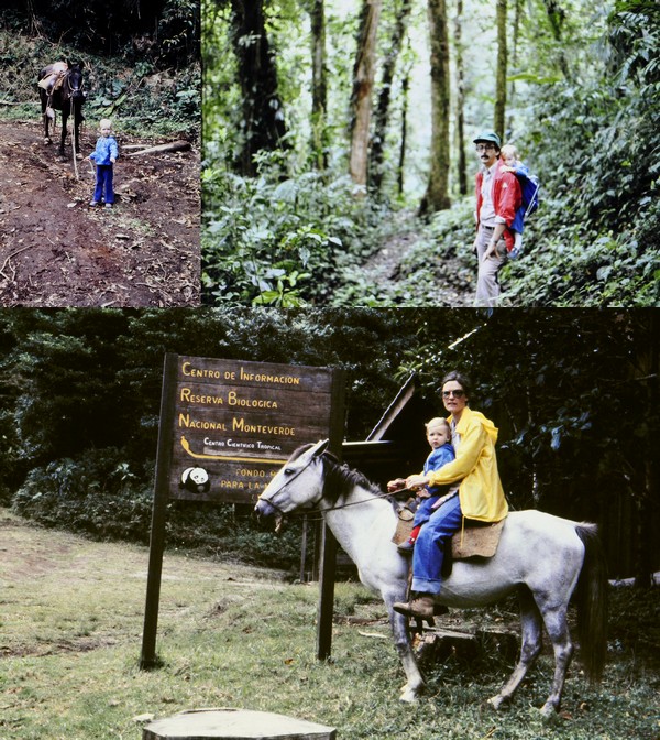
Between 1973 and 1981 we lived in Peru and Costa Rica (in Central America), and from 1991 spent almost 19 years in the Philippines (from where we traveled to and down the east coast of Australia). We also made two road trips around Ireland in the 1990s while on home leave from the Philippines. Our road trip experiences were very different.
Since retiring in 2010, however, Steph and I have enjoyed several road trips around the UK. taking in Scotland in 2015, Northern Ireland in 2017, Cornwall in 2018, and Sussex and Kent in 2019.
And, since 2010, we have (until the Covid pandemic struck) visited the USA every year and made some epic road trips that are described briefly later on.
Touring Peru
A couple of months after I arrived in Peru, the ship carrying my Volkswagen finally docked at Callao, the port for Lima. It was just the right sort of vehicle for the rugged roads that Steph and I traveled exploring that fascinating country. Solid suspension (although I did add heavy-duty shock absorbers) and an air-cooled engine.
Almost five decades ago, there were few paved roads in Peru, the main one being the Panamerican Highway stretching the whole length of the country, just a single carriageway in each direction. And the Carretera Central from the coast to the central Andes at Huancayo, crossing the high pass at Ticlio on the way.
Most elsewhere, apart from in the towns and cities, the roads were unpaved. And through the Andes, these roads followed the contours of the valleys. Often you could see your destination in the valley below, but know there would be many kilometers to travel as the road snaked down the valley, as you can see in these photos.
Above Tarma on the road to San Ramon
Then there was the ever-present danger of landslides which might take hours if not days to clear, or precipitous drop-offs at the side of the road. I remember on one occasion driving along one road (in fog) in the north-central part of Peru, and afterwards checking the maps to discover that the drop was about 1000 m.
Three of the most interesting trips we made were to Arequipa and Puno on the shore of Lake Titicaca in the south of the country, to Cajamarca in the north, and to Ayacucho and the central Andes on another occasion.
In Costa Rica
Many of the roads in Costa Rica were paved when we lived there in the mid-70s, with some notorious exceptions. Turrialba, where we lived, lies 41 km due east from Cartago (San José lies a further 19 km beyond Cartago). From Turrialba to Cartago, there’s a climb of almost 800 m, passing through a cloud zone (zona de neblina) on a narrow and twisting road that was, back in the 1970s, unpaved for most part.
Further this was the main route from the Caribbean port of Limón on the east coast to San José, and was always busy with one juggernaut after another. Not to mention the tractors towing a dozen or more sugar cane carts along sections of the road, without any hazard lights whatsoever.
The Philippines
Mostly, the Philippines has good roads. It’s just the congestion and the lack of driver discipline that makes driving in that country stressful. Also, farmers drying their rice or maize harvest along one side of an already narrow road.
Drying maize along the highway in Nueva Ecija, north of Manila. The more numerous rice farmers do the same.
We lived in Los Baños, the Science City of the Philippines, location of the University of the Philippines-Los Baños, the Institute of Plant Breeding, a local office of PhilRice, as well as the headquarters of the International Rice Research Institute (IRRI) where I worked for almost 19 years.
Los Baños is sited along the shore of Laguna de Bay, and on the lower slopes of a dormant volcano, Mt Makiling. It’s almost 65 km south of Manila and, on a good day, a little under 90 minutes by road. Back in the day we used to joke that it took anywhere between 90 minutes and a lifetime to make the journey. Major road improvements took almost 15 years to complete and with traffic congestion (caused mainly by tricycles and jeepneys) the journey could take several hours. Here’s a short video of a trip to Tagaytay (a town that overlooks the Taal volcano), about 50 km west of Los Baños by the quickest route (map).
In 2009, my staff, Steph and I made a long-weekend trip to the world-famous rice terraces in the Ifugao-Mountain Province of northern Luzon. Staying in Banaue, we took a jeepney to the end of the trail leading to the Batad rice terraces.
From there we had to hike for well over an hour deep into the valley.
Steph and I would also spend about eight weekends a year on the coast at Anilao (map) where I scuba dived and she would snorkel.
When we first visited Arthur’s Place in March 1992, there was no passable road from Anilao to the resort, and we had to take a 30 minute outrigger or banca ride. By 2009, the road had been paved.
Touring the USA
I really enjoy driving in the USA, once I’d become familiar with a number of the driving norms and the various road signs. Our elder daughter lives in Minnesota so our trips have begun or ended there. Thank goodness for the interstate highways whose construction was begun under President Eisenhower in the 1950s. We prefer to follow the US or state highways mostly if we can, even county roads.
These are the trips we have taken:
2011 – the southwest states of Arizona and New Mexico, taking in the Grand Canyon, Monument Valley, Canyon de Chelly, among other wondrous sights.
2015 – since we had already traveled round Scotland earlier that year, we visited Chicago by train instead.
2016 – I’d broken my leg in January, so when we visited in September, we spent a few days seeking out the source of the mighty Mississippi in Minnesota.
And, along these travels, one thing that caught my attention. In the UK, road construction has involved the building of just a few major bridges, over river estuaries, the most recent being a second bridge crossing the Firth of Forth west of Edinburgh in Scotland.
Not so in the USA. East-west or north-south, immense bridges had to be constructed across the many rivers that criss-cross that vast country. Some of the most impressive have been along the Mississippi, Missouri, and Ohio Rivers.
Simon Kenton Memorial Bridge over the Ohio River at Aberdeen, OH connecting OH and KY on US62.
Champ Clark Bridge carrying US54 from IL to MO at Louisiana, MO.
Bridges over the Ohio and Mississippi Rivers at Fort Defiance State Park, connecting KY, IL and MO.
South Grand Island Bridge over the Niagara River, NY.
Do you remember all the places and houses where you have lived? I do. Such varied and (mostly) happy memories.
I left my parents’ home in Leek (a small market town in North Staffordshire) at the beginning of October 1967, almost 19 years of age, to study at university; I only went back for short visits during vacations. Less than six years later I was headed for new adventures overseas living in Peru, Costa Rica, and the Philippines (with a break in between of 10 years back in the UK) over the next 40 years.
Early days in Congleton
I was not born in Leek however, although to all intents and purposes I consider it my home town. We moved to Leek in April 1956 from Congleton in Cheshire. I’d turned seven the previous November.
In Congleton, we lived at 13 Moody Street just a few minutes walk away from the offices and print shop of the Congleton Chronicle newspaper on the High Street where my father worked as staff photographer. No. 13 was owned by the Head family, then proprietors of the Chronicle.
It is a three-storey property. Back in the day, the attic rooms on the top floor weren’t furnished, and we used them as play rooms on wet days. On the ground floor, it seems to me that we hardly ever used the front parlor. A room, the width of the building at the rear of the house, served as dining and living room, with a kitchen and larder off to one side.
Taken in Congleton in about 1952 or so. L to R: Mike, Martin, Margaret and Edgar
My best friend Alan Brennan, a year younger than me, lived just a few doors further up Moody Street. But we didn’t go to the same school. I was enrolled at Mossley C of E village school, a couple of miles south of the town, like my two brothers and sister before me. Each weekday morning, my elder brother Edgar (just over two years older than me) and I took the bus together from the High Street to Mossley. Sometimes, in the summer, I’d walk home on my own (something that parents wouldn’t even contemplate today).
In the early 1950s we made our own entertainment. We didn’t have television. (In fact my parents didn’t own a B&W TV until about 1964). During the summer we’d play outside until dark, even walking the mile south to the Macclesfield Canal where we had fun on the swing bridge (now replaced by a static bridge), or hiding in the old air raid shelter near the cemetery on the way to the canal.
May Day, early 1950s. The kids of Moody Street. That’s me on the extreme left.
In the winter, we tobogganed on Priesty Fields nearby. We also had the Saturday matinee at one of the local cinemas, the Premier on Lawton Street (now demolished and the site of Congleton in Bloom Community Garden) enjoying Laurel and Hardy, or B movie westerns with the Lone Ranger, and Hopalong Cassidy, to name a few of the movie stars we emulated in our games. Happy days!
Thinking of my early years in Congleton makes me realize we did not have the luxury of central heating either in the house or at school. In fact, at home, we must have sat around a small fire in the living room to keep warm.
At school, we actually had a large coal fire in the classroom. Can you imagine? No Health and Safety Executive to put a stop to that. All that separated us from the inferno was a large fire guard. Even when I was in high school in the late 1960s each pupil was entitled to a small bottle (1/3 pint) of milk daily. I doubt that continues today. Anyway, at Mossley during the winter, we would place our frozen bottles of milk in front of the fire to thaw.
65 St Edward St, Leek
Moving to Leek
My parents decided to set up on their own in Leek, and took over an existing photographic business at 65 St Edward St, on the edge of the town center. Not an ideal location, but as an ongoing concern, I guess it was the most appropriate approach to enter the retail trade.
It was by no means a large property, for a family of six. We three brothers shared a bedroom on the front of the property (the top window in the photo on the right). My parents had their bedroom at the rear. That property didn’t have central heating either.
On the first floor was the bathroom/ toilet, and at the front of the house, an L-shaped living room. My sister Margaret (then 15) had her own private space and bed in the ‘L’ of that room. Not an ideal situation, but there was no other alternative. In July 1957 my eldest brother Martin left to join the Royal Air Force, and thereafter we saw him at home only on leave.
The kitchen was located on the ground floor, behind the shop and we ate most of our meals there, only moving to the first floor room for special family meals like Christmas. My father converted the cellar into his photographic dark room.
A side entrance led to an enclosed yard, Court No. 3, with three or four cottages, none with toilets or bathrooms, but probably just one tap of running water. These were demolished not long after we moved into No. 65, and we then had a large open space to play in.
With my best friend Geoff Sharratt (who lived at The Quiet Woman pub a few doors away) playing with my Hornby clockwork train set.
Winter fun and games with my brother Ed (center), me (crouching), and one of our friends, behind 65 St Edward St, after the cottages had been demolished.
I remember well-attended Christmas parties at No. 65, Christmas lunches around a table in the first floor living room.
Around 1960 or 1961, the lease came due on No. 65 and my parents decided not to renew the tenancy, opting to try and find a better location in the town. That took a couple more years.
In the interim, they moved the shop across St Edward St to No. 56, that was a fine porcelain retailer at the time. When we visited Leek in 2019 it was once again the premises of a photographer, and we discovered other earlier historical links.
My dad took on that fine china business, moving his photographic business there. For about six months we didn’t actually have a house. We had a room behind the shop, and a small kitchen, and a caravan on a farm a few miles north of the town. Somehow we managed, until an apartment became available at the top of the Market Place, at No. 26, above a building society.
No. 26, the red-brick building on the right at the top of the Market Place. We occupied the two upper floors.
We stayed there about two years, even over the coldest (and longest) winter I can remember, 1962/63. Everything froze and we had no running water for almost 10 weeks. Dad’s business was still operating from No. 56 St Edward St.
Then, a semi-derelict property (formerly a watchmaker’s) came on the market at No. 19 Market Place. Despite considerable trepidation on the part of my mother, Dad sold her on the idea of purchasing the property because of its central location in the town, and renovating the two upper floors into a comfortable apartment.
No. 19, with the yellow and black ‘Jackson’ sign, in between Jackson Optician (no relation) and Victoria Wine in the early 1960s. No. 26 is the building on the extreme right at the top of the Market Place.
The renovation was no easy task. There was only one tap in the property, in the cellar. No bathroom or toilet, and no central heating. These all got added and we must have moved in by late 1963, since my sister Margaret had married David by then and they took over the tenancy of No. 26.
The views over the Market Place from both No. 26 and No. 19 were great, being right in the heart of the town. Each Wednesday there was a busy market (you don’t see many of those any more, and I don’t think Leek market runs in the same way any more).
And both were great vantage points to watch the Club Day (or Walking Round Day) procession each July, which I used to take part in when a small boy.
Assembling in the Market Place on Club Day. This was taken around 1960 or so. The awning over the premises of J Cosgrove (watchmaker) is clearly seen at the top of the image. That is No. 19 Market Place before it became my father’s premises.
University days
Mum and Dad lived at No. 19 until 1976 when they retired. But I had moved out almost a decade earlier, when I headed south to study at the University of Southampton from 1967 to 1970. For the first two years I lived in South Stoneham House, one of the halls of residence just under 1¼ miles from the campus. I lived in the 16 storey tower block, not the original Queen Anne house to which it was attached. I’ve since learned that the grounds were designed by 18th century landscaper, Capability Brown. The tower was condemned for occupation in 2005, partly because of the asbestos in the building. But also the fabric of the tower (built in the 1960s) had deteriorated, and conditions for students were described as ‘squalid’.
South Stoneham House
It was due to be demolished earlier this year. This is how it looked until then, shrouded in scaffolding and plastic sheeting. Very sad. We had happy days there.
In my final year (1969-70), I moved to digs (half-board accommodation) at 30 University Road, just down from the newly-opened university administration building and bookshop on the southeast side of the campus. Within a year or so of leaving Southampton many of the houses along University Road had been bought up by the university and became annexes to university departments. No. 30 was demolished.
This is No. 28. No. 30 to its right has been demolished and stood where the trees now stand.
In September 1970, I moved to Birmingham to begin a 1-year MSc course in genetic conservation. I rented a room in a house on Portland Road in the B16 Edgbaston area of the city, and a 2 mile walk to the campus. I think it was the one on the extreme left. But it was more than 50 years ago, and many properties along Portland Road look different today.
After one year, as I started my PhD research, I joined two engineers in an apartment south of the campus on Abdon Avenue. It was certainly one of the apartments on the left of the entrance, but I don’t remember if it was the first or top floor.
I stayed there until December 1972 when I prepared to leave the UK and head to warmer climes, in Lima, Peru to join the International Potato Center (CIP) as an Associate Taxonomist.
Off to South America
Arriving in Lima at the beginning of January 1973, I lodged for about three weeks in the Pensión Beech (now demolished it seems) on Calle Los Libertadores in the San Isidro district of the city. Then I had to start looking for an apartment to rent.
I found a furnished one-bedroom apartment on the 12th floor of a tower block on Los Pinos in the Miraflores district, close to the Pacific Ocean coast. I don’t have any clear images of the building. I’m not sure it’s even still standing after 50 years. In 1973 it stood apart beside a vacant lot, and next to a Todos supermarket (long since disappeared).
Steph joined me at the beginning of July that year, and very soon we decided that the apartment was too small. We married in Miraflores in October that same year.
At our Los Pinos apartment, just after Steph arrived in Lima in July 1973.
We quickly found a furnished two-bedroom apartment on Avenida Larco just around the corner. Parking was on the first floor, accessed by a lift from the street. At street level, there was an ice cream parlor, Veinte Sabores (20 Flavors), now replaced by a commercial outlet named Mardigras.
The apartment was on the top (12th) floor, on the rear of the building with a view to the coast.
A view to the Pacific Ocean over the Miraflores rooftops.
In October 1974, the coast of Peru was hit by a major earthquake, more than 8 on the Richter Scale. Living on the 12th floor was not so comfortable then, and for many weeks there were countless aftershocks which didn’t do much for our nerves.
So by Christmas that year, we’d moved out to house-sit for several colleagues while they were on home-leave, until the following May when we were returned to the UK for six months. I had to complete the PhD residency requirements at the university and defend my thesis.
We landed in Birmingham at the end of May 1975 having returned to the UK via Panama, Costa Rica, and Mexico. We found a one-bedroom apartment in a large house on Farquhar Road close to the campus, which had been converted to about five apartments, with the owner occupying the ground floor.
The ‘bridge’ connecting the house to the garage was our bathroom.
We stayed there until the end of the year before returning to Lima, spending a few months in the CIP Guesthouse. But we didn’t remain in Peru for much longer. CIP asked me to move to Costa Rica in April 1976 to set up a potato breeding program focusing on Mexico, Central America, and the Caribbean.
Moving to North America (actually Central America)
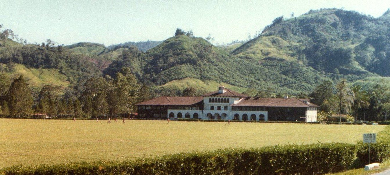
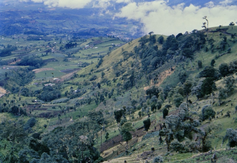
CIP signed an agreement with CATIE, a regional research and training center in Turrialba, some 70 km east of the capital, San José. It was a campus institute, nestling below the Turrialba Volcano, and was the headquarters of the Inter-American Institute for Cooperation on Agriculture (IICA) from 1942 until 1976 (when it moved to San José).
The Turrialba volcano from the town below.
Initially, we stayed in CATIE’s guesthouse, then moved into a rather run-down house in the #109 sub-division just outside the campus before eventually moving on campus. We rented a two-bedroom detached house with a lovely garden, full of fruit trees, and the most wonderful wildlife: birds, mammals, and reptiles (some very venomous). Our elder daughter Hannah was born there in April 1978, so these were very special years we spent in Turrialba.
In our garden, probably early 1977.
Hannah enjoying a stroll around the garden in 1979.
I don’t have any decent images of the house that we occupied until November 1980 which, after we left, became additional space for the international school nearby.
Hannah visited Costa Rica in 2002, and took these two photos of the house. The upper image shows the car port and rear door to the house (which we used as our main entrance). The lower image shows the front door and living room to the right and Hannah’s bedroom left of the door.
By the end of 1980 I was looking for a new challenge and asked CIP’s director general for a new posting. We returned to Lima and several more months in the guesthouse. In the meantime, however, I had successfully applied for a teaching and research post at the University of Birmingham. I resigned my post at CIP, and we returned to the UK in March 1981 in time for my 1 April start date at Birmingham.
We then set about finding somewhere to live. Within a week of so we had put in an offer on a house in Bromsgrove, a market town in north Worcestershire, about 13 miles south of the campus.
Back in the UK – Bromsgrove
Located just under a mile east of the town center, our three bedroom house was built in 1975. In 1982, just before our second daughter Philippa was born, we extended the kitchen on the front of the house. In 2015 we installed an electric garage door and had the front drive re-paved.
The garden was Steph’s pride and joy, that she carefully nurtured over almost 40 years.
Growing up, Hannah and Phil attended the local schools, and had a wide circle of friends living close by. The house always seemed filled with a small group of girls. And each year there were two birthday parties to organize.
Philippa’s 6th birthday party in May 1988. She is sitting facing the camera on the left, and Hannah is standing.
But that’s not the whole story. Yes, we owned No. 4 for 39 years, but for 19 of those, we lived in the Philippines, only returning to the UK in May 2010. In fact, our stay in the Philippines has been, to date, the longest continual period I have lived anywhere.
In July 1991, I accepted a position at the International Rice Research Institute (IRRI) in Los Baños, some 70 km south of Manila. From the outset we decided to keep No. 4 empty but fully furnished, which we could occupy when we returned to the UK on our annual home-leave. We thought having tenants and the like just wasn’t worth the hassle. In any case, we had a ‘bolt hole’ should our assignment in the Philippines not live up to expectations or the civil/political situation deteriorated to an extent that we might have to leave.
Asia calls
IRRI provided houses for its senior, mainly non-Filipino staff in a gated community about 10 minutes drive from the research center, across the campus of the University of the Philippines – Los Baños (UPLB). IRRI Staff Housing or ISH as it became known, was developed on the lower slopes of a dormant volcano, Mt Makiling that dominated the skyline over the town.
Mt Makiling from the IRRI Research Center.
Founded in 1959/60, the construction of the IRRI research center and housing began in 1961.
ISH takes shape in July 1961, with Laguna de Bay in the distance.
On the lower slopes of Mt Makiling, ISH takes shape in December 1961, and almost ready for occupation. Our house, No. 15, is the fourth from the bottom, middle column.
Los Baños has grown along the shore of shallow Laguna de Bay (911 km²) that stretches all the way north to Manila, a little over 65 km by road. (Click map to enlarge).
The video below (from my good friend and former IRRI colleague Gene Hettel who has retired in the Philippines near Los Baños) shows the panoramic view over the volcano and lake.
By 1991, ISH was unrecognizable from the site thirty years earlier. Mature trees covered the compound, and everywhere was lush with vegetation. The houses however, were beginning to show their age, and some of the facilities, like the kitchens had never been updated, and that remained the case for House #15 that we occupied until we left the Philippines almost 19 years later.
We had the use of a swimming pool, tennis and basketball courts, and the ISH compound was a safe place for all the children to play, often inventing their own games that were passed down from year to year over the decades. I guess an important downside of living in Los Baños was schooling for the children, most of whom attended the International School in Manila, entailing for many years a two hour journey each way, and an ungodly start time (by the end of the 1990s) of 4:30 am!
While Peru was a country of earthquakes, Costa Rica had its volcanoes, the Philippines had both of these AND typhoons. Several would sweep in from the Pacific Ocean each year and cross the country leaving a trail of destruction in their path. These images show some of the damage around ISH and the UPLB campus in the aftermath of Typhoon Milenyo in September 2006, which passed almost directly overhead, with winds approaching 150 mph.
As often as we could we’d get away to the beach, at Arthur’s Place south of Los Baños where Steph would snorkel and I would scuba dive.
8 Dec 2002: in front of Arthur’s Place
All things come to an end, and by 2009 I’d already decided not to seek another full contract, just extending my current one by a year and then retiring. We returned to the UK and our Bromsgrove home in May 2010.
However, by the end of 2019 we had eventually decided to leave Bromsgrove and move north to Newcastle upon Tyne where our younger daughter Philippa and her family live. (Our elder daughter lives in Minnesota).
So, in January 2020, we put No. 4 on the market, just before the first Covid-19 lockdown. By the beginning of June we’d received an offer that we accepted and began making plans for the move.
We completed the sale on 30 September and moved out that same day.
The removers on their way north!
Goodbye to No. 4.
The following day we moved into a 3-bedroom detached house that we rented for the next six months in the West Allotment area of North Tyneside (east of the city center) while we looked for a new home to buy.
Move-in complete at Cloverfield by 15:55 on 1 October 2020.
We took a week to get ourselves settled and find our local bearings. But then began the search in earnest for a new home. And found just the house almost immediately, viewing it one morning and putting in an offer that same evening. The conveyancing to purchase the property was not as straightforward as we and the vendors expected, but the sale/purchase was finally completed on 15 February last year. We moved in on 6 March.
Finally settled.
Yes, finally settled. A warm, well-appointed home. Only the garden to sort out, and almost from Day 1 Steph has been busy designing, planning, and developing her new garden.
April 2021 and beyond.
And although we enjoyed living in Worcestershire, the prospect of many more treats to come in beautiful Northumberland is something we look forward to.
So sang Florrie Forde in her November 1909 recording of the popular 1907 British music hall song of the same title.
A few days back, the weather being the warmest and sunniest of the year so far, Steph and I took a walk along the coast south of the River Tyne here in the northeast of England, and about 11 miles from home. And as we sat down on Marsden Beach to enjoy our picnic lunch, I told Steph that I still had to pinch myself that we now lived so close to the coast.
The magnesian limestone cliffs at Marsden Bay.
We moved to North Tyneside (just east of Newcastle upon Tyne city center) 18 months ago, and whenever we get chance, we head off to the coast to enjoy a bracing walk along the beach, the dunes, or cliffs. At its closest, the coast is less than 4 miles as the crow flies.
I hail originally from Staffordshire in the north Midlands, which is almost equidistant from the west and east coasts. So, when I was growing up, a trip to the seaside was always a treat, and holidays with parents were almost always spent camping at or near the coast.
Steph, on the other hand, comes from Southend-on-Sea and the closest beach to her family home was just 5 minutes walk.
Moving away to university in 1967, I chose Southampton on the south coast in Hampshire. However, apart from the odd day trip or field excursion connected with my botany and geography degree, I didn’t see much of the coast at all. Not so a decade earlier. Southampton is a major seaport, from where my father sailed when he worked for the Cunard company in the 1930s. And he took us visit the docks in the late 1950s/early 1960s just when both of Cunard’s Queens were in port.
RMS Queen Elizabeth
RMS Queen Elizabeth
RMS Queen Mary
RMS Queen Mary
When Steph and I moved to Peru in 1973, we lived just a few hundred meters inland from the cliffs overlooking the Pacific Ocean in the Lima suburb of Miraflores. During the ‘summer’ months between January and March, we’d spend at least one day each weekend on the beach at one of the resorts about 50 km south of Lima.
The view to the Pacific Ocean from our apartment
The coast south of Lima
Moving to Costa Rica in 1976, we made only two trips to the beach in the northwest of the country to Playa Tamarindo on the Pacific coast of the Guanacaste peninsula (map). It was about 350 km (almost 7 hours) by road, but new routes have probably made the journey quicker since then. And just one trip to the Caribbean coast at Limón.
In the Philippines, we made about eight or nine weekend visits each year (over almost 19 years) to Arthur’s Place, a dive resort at Anilao on the Mabini Peninsula (map), a drive of just under 100 km south from Los Baños that, in 1992 (until about 2005), used to take about 3 hours. I’d go diving and Steph would snorkel.
OLYMPUS DIGITAL CAMERA
In December 2003 we traveled to Australia and drove down the east coast from Sydney to Melbourne, around 1000 miles, enjoying each stretch of coastline every day. At Wilson’s Promontory in Victoria we stopped off at Tidal River, the furthest south (at almost 39°S) I’ve ever traveled. Antarctica next stop! And that same evening, New Year’s Eve, we sat on the beach near Wonthaggi and watched the sunset over the Indian Ocean (map).
Christmas Day at Bondi Beach.
Hanggliders at Stanwell Park
Seven Mile Beach south of Kiama
Jervis Bay
At Tidal River
Wilson’s Promontory looking south to Antarctica.
New Year’s Eve on the beach nr. Wonthaggi
Since retiring, we’ve visited the west and east coasts of the USA in Oregon and California, and Massachusetts and Maine, the coast roads right round Scotland, the coast of Northern Ireland, as well as Cornwall, and the southeast of England in East Sussex and Kent.
Oceanside, OR from Cape Meares
Oregon coast nr. Netarts
Coast south of Netarts, OR
Herring Cove beach, Cape Cod, MA
Sailing on West Penobscot Bay, ME
Nr. Beauchamp Point, Rockport, ME
The Lizard, Cornwall
Tintagel Castle, Cornwall
North Cornish coast
At the White Cliffs of Dover, Kent
Crossing the shingle at Dungeness, Kent
The Seven Sisters at Birling Gap, East Sussex
Looking east from Dunnet Head towards Thurso, Scotland
At the Butt of Lewis, Outer Hebrides
South Harris beach, Outer Hebrides
South Harris, Outer Hebrides
South Uist beach, Outer Hebrides
Looking west to Barra from Eriskay, Outer Hebrides
Isle of Skye
Giant’s Causeway, Co. Antrim, Northern Ireland
While here in England’s northeast (North Yorkshire, County Durham, and Northumberland) we don’t enjoy tropical temperatures, the region does boast some of the finest stretches of coastline and beaches in the country.
Dunstanburgh Castle and Craster
This is a rocky coast and the castle itself was built in the early 14th century on the Whin Sill, an outcrop of igneous dolerite that cuts across Northumberland. The castle is a walk of about 1¼ miles from the fishing village of Craster; there’s no road into the castle.
Craster itself has ample parking away from the harbor. The village is also famous for its smoked fish, especially kippers.
At Dunstanburgh a healthy population of kittiwakes nest on the cliffs.
To the north there are excellent views of Embleton Bay that we have yet to visit.
View north from the Great Gatehouse
Alnmouth
A tricky pronunciation. Some say ‘Aln-muth’, others ‘Allen-mouth’. I have no idea which is correct. It’s a pretty village at the mouth of the river of the same name. There’s good paid parking behind the beach for a couple of hundred cars.
Warkworth
We’ve only visited the beach once, back in April 2018. It’s a nice long stretch of beach accessed from the north side of the town, which is more famous for its 12th century castle.
Looking north along Warkworth beach towards Alnmouth.
Warkworth Castle
Amble
Standing at the mouth of the River Coquet, we’ve found the beaches very pleasant on the south side of the town (where there is free parking), and facing Coquet Island which is now a bird reserve with an internationally important colony of roseate terns in the breeding season.
The view south along the Amble beach with the Lynemouth power station in the far distance.
Coquet Island.
Druridge Bay and Hauxley Nature Reserve
This must be one of the longest beaches in Northumberland, with massive dunes at the rear of the beach in its southern portion.
At the northern end, and just inland is Hauxley Nature Reserve, owned by Northumberland Wildlife Trust. When we visited last week, we observed 37 different bird species in the space of two hours. It really is a wonderful site, and we must go back there on a regular basis. There’s no entrance fee, but parking costs £2 all day. There’s also footpath access on to the dunes and beach, which lie just beyond the reserve’s perimeter fence.
The Tern Hide from the West Hide at Hauxley Nature Reserve.
The North Sea can be seen in the middle distance beyond the dunes and reserve perimeter fence.
Cresswell Bay
This was one of the first ‘northern’ beaches that we viisted in 2021, just 17 miles from home. It’s both sandy and rocky, and we saw somone collecting sea coal that had been washed up on the shore. All along the Northumberland and Durham coast there were once extensive coal mines. Waste from the pits was dumped in the sea. In places the beaches look quite black.
Blyth and Seaton Sluice Beaches
These are the closest to home, but are in effect a singe beach. Both are very popular with dog walkers, and we enjoy often heading there on a Sunday morning, weather permitting, for a late morning stroll.
At the Seaton Sluice southern end of the beach, there is a small harbor, that had originally been constructed in the 17th and refurbished in the 18th century to handle coal shipments from local mines.
Seaton Sluice harbor, showing ‘The Cut’ in the middle distance.
St Mary’s Lighthouse and Whitley Bay
The lighthouse was built in 1898, but there had been lighthouses on the island for centuries. This lighthouse was decommissioned in 1984. The island lies at the north end of Whitley Bay, a popular resort.
The island is approached across a causeway that is submerged at high tide. On the visits we have made we’ve often seen the grey seals that bask on the rocks.
King Edward’s Bay, Tynemouth
This is a small bay that lies beneath the headland on which Tynemouth castle and priory (now owned by English Heritage) were built.
From the headland there are magnificent views north along the Northumberland coast.
To the immediate south is the mouth of the River Tyne, and beyond the shore at South Shields and the coast south into County Durham.
Souter Lighthouse and the Whitburn coast
The lighthouse was decommissioned in 1988. It stands on the edge of magnesian limestone cliffs, that stretch both north and south.
To the south of the lighthouse, there was a colliery and this area has been reclaimed and opened (under the National Trust) as a recreational area.
Immediately outside the walls of the lighthouse to the north is the site of a former mining village, Marsden, that was demolished soon after Whitburn Colliery closed in 1968.
The longer grass indicates where the two lines of terraced cottages once stood.
Marsden beach was very popular holiday or day-out destination in the early 20th century.
The cliffs are home to colonies of cormorants (one of the largest in the UK), herring gulls, kittiwakes, and fulmar petrels.
Whitby Abbey
The abbey, built in the 13th century, occupies a headland that juts out into the North Sea above the town of Whitby. It’s the furthest south we have ventured over the past 18 months.
The approach from the north along the A174 high above the coast affords the most spectacular views over the town and right along the North Yorkshire coast. Most impressive.
I don’t think I’ll ever tire of visiting the seaside. There’s something magical, inspirational about the interface between land and sea. Solid and liquid.
The Lincoln Highway. America’s first transcontinental highway, opened in October 1913. Three thousand, three hundred and eighty-nine miles!
If you’re traveling east to west, it begins in Times Square in New York and, originally crossing twelve states, ends at Lincoln Park in San Francisco on the west coast in California. Originally there was a ‘Colorado Loop’, removed in 1915, and in 1928, the route was realigned to take in northern West Virginia.
Over the years, however, the Lincoln Highway was subsumed into the US numbered highway system, with much of the section between Pennsylvania and Wyoming becoming part of US 30. Nowadays, I-80 west of Chicago follows much the same route as far as I can determine, although in places to the south of US 30.
So what’s this interest in the Lincoln Highway, and US 30?
Well, I’ve just finished reading The Lincoln Highway by Amor Towles, published in 2021. It’s an unusual tale of three teenagers and an eight year old boy who travel from Nebraska to New York. However, from the outset, the intention was for Emmett Watson and younger brother Billy (the main characters), to take the Lincoln Highway westwards to California in search of their mother who had abandoned the family some years earlier. And the only idea of where she might be is a series of postcards sent over nine days after she departed, from locations along the Lincoln Highway.
But instead of trying to explain the rationale of the book, let author Amor Towles tell you himself.
Towles’ previous books, Rules of Civility and A Gentleman in Moscow were published in 2011 and 2016, respectively, to considerable acclaim. I found The Lincoln Highway somewhat of a strange read, even though several reviewers gave it high praise. I decided to take it up after a friend posted a comment on Twitter about her enjoyment of this book.
I’m not so sure. About one third of the way through, I had to put it to one side for a while. I found the pace, and the literary tangents, not to my liking. Although, on reflection, it’s precisely those tangential narratives that are the mainstay of the novel. I guess I’d been expecting to read a more traditional travelogue about the Lincoln Highway. In many respects it is, but not the one I ‘hoped’ for. And since the narrative commences in Nebraska, about half way along the Highway, it emphasizes the in medias res approach of the author (and his characters), where the narrative skips forwards and back.
At the end of the novel we finally see Emmett and Billy heading to Times Square to commence that long journey westwards: the whole route, not just the western half that was promised at the beginning.
I try not to read too much into any novel that I take up. I had enough of literary analysis when I studied English Literature in high school for my pre-university exams. I like a narrative to take me along, and I particularly like to see how an author uses language to paint literary images. Amos Towle has a most acceptable writing style.
However, there’s another aspect of the Lincoln Highway that grabbed my attention. Being of a geographic bent, I went online to discover more about this particular transcontinental artery.
Since 2011, Steph and I have made some special road trips across America, and in the last one, in 2019, before the Covid pandemic prevented our return to the USA, we traveled from Massachusetts, through New England, around New York, down through New Jersey, across Pennsylvania, and south through Maryland and Virginia, before flying on to Minneapolis-St Paul from Baltimore.
Much of our route through Pennsylvania was on US 30, and indeed during earlier road trips we had crossed or traveled short distances along the same route in Ohio (at Canton), in Indiana, and Iowa. Now, we didn’t make our road trips in a vintage Studebaker like Emmett and Billy (and their ‘companions’ Duchess and Woolly). But, when I saw the cover of The Lincoln Highway, it took me back to the road trip Steph and I made to the American Southwest in 2011, when we checked out that other iconic highway, Route 66, near Holbrook and the Petrified Forest National Park in Arizona.
Perhaps it’s just the call of wide open spaces, but American road trip narratives have almost become a genre of their own, and one that I would like to contribute to more myself, given half the chance.
You can check out some more of our road trips under ‘USA’ on this page.
Over recent weeks, Steph and I have been enjoying the latest series of Digging for Britain on BBC2, hosted by Alice Roberts who is Professor of Public Engagement in Science at the University of Birmingham. In this ninth series (as in the earlier programs) she visited digs all over the UK where archaeologists were busy uncovering our distant (and not-so-distant) past, and the lives of the people who lived there.
In one program she visited a (secret) site in Rutland (England’s smallest county in the East Midlands) where, in a farmer’s field, the most remarkable Roman mosaic floor had been uncovered, depicting scenes from the Trojan War. This was only one of many treasures that were ‘discovered’ during the series.
The British landscape has been transformed by multiple waves of immigration and conquest over thousands of years. But scrape away the surface, as archaeologists are wont to do, and fascinating histories begin to emerge, from prehistoric times through to the arrival of the Romans in AD 43, and in the centuries afterwards.
Sites like Stonehenge or the Avebury Stone Circle remind us that humans were living in and modifying these landscapes thousands of years before the Romans arrived on these shores.
Avebury Stone Circle.
Northumberland in the northeast of England (where I now live) is particularly rich in Roman remains. Besides the iconic Hadrian’s Wall, forts like Housesteads or Chew Green, and towns like Corbridge and Vindolanda are a visible reminder that these islands were once under the military control of an empire the like of which the world had never seen before. Northumberland was the northwest frontier.
And after the Romans departed in the 5th century AD, northern tribes such as by Angles, Saxons, and Jutes from continental Europe made these islands their home.
However, I often view our landscape as essentially post-Norman (that is, after 1066) since the Normans (and their descendants) left so many statements of their hegemony: magnificent castles (such as Prudhoe, Warkworth, and Dunstanburgh that stand as proud ruins even today), manor houses, churches and abbeys, and royal hunting parks.
I guess our appetite for the archaeological past was whetted when we moved to Peru in 1973. Within two weeks of landing in Lima in January I had already visited Machu Picchu while attending a meeting in Cuzco. Then, after Steph arrived in Lima in July, we spent many weekends exploring the coast and heading off into the numerous valleys that lead inland from Lima. In December, I took her to Machu Picchu (for a delayed honeymoon!)
Over the three years we spent in Peru, five in Central America, and more recently in the southwestern United States, we have visited a number of iconic pre-Columbian archaeological sites, and others less well known.
It’s not just the remains that various cultures have left behind, however. It’s also understanding their connection with the environment, the types of agriculture practiced for example, and the crops that were domesticated and brought into cultivation (a particular interest of mine).
So permit me to take you on a brief archaeological travelogue through the Americas.
Hiram Bingham III
As I’ve already mentioned Machu Picchu, perhaps I should start there. I guess it’s not only the location of this Incan refuge, but something of the mystery that surrounds it until it was ‘discovered’ by Hiram Bingham III in 1911 (although there are earlier claimants).
But tales of a lost city in Peru certainly caught the public imagination, and soon Machu Picchu was a notable tourist destination. In 1973, the rail journey between Cuzco and Machu Picchu was slow and left early in the morning. Nowadays the line has been upgraded and beside the river (way below the ruins) a small town has sprung up to accommodate the multitude of tourists who descend on Machu Picchu daily from all over the world.
I made just a day visit there in January 1973. However, Steph and I were lucky to reserve a room at the turista hotel that once stood just outside the ruins. So, once most tourists had returned to Cuzco late in the afternoon, we (and a handful of other hotel guests) had the ruins to ourselves. Next morning we breakfasted early to watch the sun rise, and enjoy the peace and quiet of this iconic site until, late morning, it was thronging once again with a trainload of tourists.
In many ways it’s not surprising that Machu Picchu remained ‘undiscovered’ for so long, five centuries after the last Inca took refuge there. Other ruins, further out into the jungle, have been uncovered in recent years, like Choquequirao, a two day hike from Cuzco.
What is remarkable about Cuzco, the Inca capital before the Spaniards arrived in the 16th century, is the juxtaposition of Incan and colonial architecture, in many places the latter built over the former. The beautiful Incan stonework is epitomized, for example, in the 12-sided stone in Calle Jatun Rumiyoc, east of the Plaza de Armas (the city’s main square).
Or the foundations of the Qorikancha temple (right) on which the colonizing Spaniards built the Santo Domingo convent five centuries ago.
Outside and overlooking Cuzco from the north is the impressive Inca fortress Sacsayhuamán (below). It’s not only its size, but especially the precision with which the stones have been placed together, some stones (like that shown below) weighing tens of tons at the very least.
Just 32 km to the northeast of Cuzco, and standing at the head of the Sacred Valley of the Incas is the market town of Pisac. Even in 1973 it was a major tourist attraction, even though it had changed little from almost 40 years previously when my PhD supervisor Professor Jack Hawkes had visited as a young man of 24. Check out these photos I took in 1973, and compare them with scenes in the film that Jack made in 1939 (after minute 25:25).
Above the town, 15th century terraces or andenes stretch up the hillside, where there are also temple remains; due to limited time we didn’t have an opportunity of exploring those nor travel further down the valley to Ollantaytambo where there are also impressive Inca remains.
Andenes above the town of Pisac.
But what is particularly remarkable about the Incas is the relative short period (perhaps a little over 300 years until the Spanish conquest in the mid-16th century) in which they held domain over many of the other cultures that had gone before them. Not only in the mountains, but on the coast as well, as I shall describe a little later.
But talking of terraces, I was fortunate to visit the small town of Cuyo Cuyo in Puno in the far south of Peru, in February 1974 while undertaking some fieldwork for my PhD research. Agricultural terraces built centuries ago are still being farmed communally today (at least when I visited almost 50 years ago).
Potato terraces at Cuyo Cuyo, Puno in southern Peru.
While some terraces had fallen into disrepair, the majority were still being carefully tended, and planted with a rotation of potatoes-oca (a minor Andean tuber crop)-barley or beans-fallow over about an eight year period. Impressive as they are, terraces like those at Cuyo Cuyo can be seen in many valleys all over Peru, but perhaps not so actively farmed as there.
Puno is one of the highest cities in the world, at just over 3800 m (12,556 ft), alongside Lake Titicaca, the highest navigable lake.
On a peninsula overlooking a lake about 33 km northwest of Puno stands a cluster of rather peculiar round towers, known as chullpas, of the most exquisite masonry, mostly ruined. Some of these stand 12 m tall. This is Sillustani, a pre-Incan Aymara cemetery site.
It seems that once this area came under Inca control, many of the chullpas were redressed with Incan masonry, much of what we see today.
One could be forgiven for imagining that the coastal desert of Peru is one huge cemetery, such is the extent of the burial sites where Moche (AD 100 -AD 800) and Chimú civilizations (AD 900 until about AD 1470 when the Incas arrived on the scene), and others, held sway leaving behind a vast array of artefacts that tell us so much about them. Having no written language, their pottery tells us much about the crops they grew, the animals they kept, even their sex lives.
Mummy bundles have been excavated in their thousands, and many of the contents are now carefully stored in one of Lima’s most prestigious museums, with just a fraction on display at any one time. Take a moment to read about the museum and its contents that I published in 2017.
All along the coast there are temples built of mud bricks, like the one below. I don’t remember exactly where this was located, but I think maybe in one of the valleys inland from the coast, 4-500 km north of Lima.
One of the more important ones lies just 40 km (or 25 miles) south of Lima. Pachacamac covers about 240 hectares, and was continuously occupied from about AD 100 until the Spanish conquest, 1300 years later.
North of Lima there are two interesting sites.
Just outside the coastal city of Casma (about 350 km or 165 miles north of Lima) stand the unusual remains of Cerro Sechín, an archaeological complex covering many hectares, and one of the oldest sites in Peru, dating back about 4000 years. The striking elements of this site are the bas-reliefs etched into the stonework depicting war-like scenes, of warriors, mutilation and the like. It really is a most unusual site. Steph and I visited there (with our CIP friends John and Marian Vessey) in 1974.
At Sechín, as at other coastal sites, the archaeological evidence shows that not only did the inhabitants practice agriculture (maize and beans being the domesticated staples) but depended on the abundant marine resources close by.
Further north, outside the city of Trujillo stand the degraded remains of Chan Chan, once the great Chimú capital covering 20 km², and built of adobe bricks. It’s regarded as the largest adobe-built city in the world. The complex comprises plazas and citadels, and because of the extremely arid conditions, many of the walls (and their carvings of animals, birds and marine life) have survived to the present.
While the coastal desert is one of the driest in the world, it does rain heavily from time-to-time, and when we visited the walls were being protected from further rain erosion.
Unfortunately, I never got to view the world-famous Nazca Lines from the air. As you cross the Nazca plain (over 400 km south of Lima) you can see some of the lines stretching into the distance but with no comprehension of what they might represent. Furthermore, indiscriminate vehicular access to this area in the past (even army manoeuvres!) has left indelible tracks across the desert, desecrating some of the incredible figures there.
The Nazca Plain from the Panamericana Sur. You can see vehicle tracks heading off into the desert.
The monkey on the Nazca lines.
On the southeastern side of the Cordillera Blanca in the Department of Ancash the ruins at Chavín de Huántar, a site that was occupied over 3000 years ago, and regarded as the oldest highland culture in Peru.
I visited there in May 1973 when collecting potatoes in that part of Peru, and again with Steph and the Vesseys a year later.
Just outside the highland city of Cajamarca (2750 m, about 180 km inland from the coast between Trujillo and Chiclayo) are the Ventanillas de Otuzco, and ancient necropolis (over 2000 years old) carved in the rock face.
Steph and I lived in Costa Rica in Central America for almost five years from April 1976. There are few remains of indigenous cultures around the country (unlike Guatemala or Mexico for instance).
However, just under 20 km north of Turrialba (where we lived) lie the enigmatic remains of Guayabo National Monument, which I wrote about in October 2017.
There’s good evidence however that this site was first occupied over 2000 years ago, until the beginning of 15th century.
In the jungle of northeast Guatemala stands the ruins of ancient Tikal, a Mayan complex dating back more than 2400 years, surely one of the most iconic archaeological sites on the planet (and which even featured in the very first Star Wars movie).
Steph and I flew there in 1977, on an Aviateca DC3, spending one night in one of the lodges. Back in the day it was possible to reach Tikal only by air, but the whole region has now opened up via roads and even an international airport in the nearby city of Flores, just 64 km to the south. I guess the site must now be overrun to some extent by tourists, much like has happened at Machu Picchu. We were fortunate to visit here, as with many of the sites I have described, before they appeared on the everyday tourist routes.
We spent hours wandering around this huge site, and managing to see just a fraction probably. It’s hard to imagine just how steep the temple steps are. No wonder Steph was out of breath. We later learned that she was pregnant when we were there.
It seems that Tikal was conquered, around the 4th century AD, from Teotihuacán from the valley of Mexico. And it’s there, north of present day Mexico City that the important temple complex of Teotihuacán can be found. Its famous Temple of the Sun and others are significant Mesoamerican pyramids standing on a site that covers 21 km². We visited there in April 1975 on our way back to the UK, staying with our friends John and Marian Vessey who had left CIP to join a sister research center, the International Maize and Wheat Improvement Center (CIMMYT) that is located not far from Teotihuacán. I’ve been back there a couple of times in the 1990s and 2000s.
Our elder daughter Hannah moved to Minnesota in 1998 to complete her undergraduate degree at Macalester College in St Paul, then registered at the University of Minnesota for her PhD in psychology. In 2006 she married Michael, and they set up home in St Paul. Grandchildren Callum and Zoë came along in 2010 and 2012, respectively. And since I retired from IRRI in 2010 and returned to the UK, Steph and I have visited them every year, and made some pretty impressive road trips across many parts of the USA. That is until Covid 19 put paid to international travel for the time being.
In 2011, we had the opportunity of fulfilling a lifetime ambition: to travel to the Grand Canyon in Arizona. So we flew from Minneapolis-St Paul (MSP) to Phoenix (PHX) to take in the Grand Canyon, and travel extensively through Arizona and New Mexico. We visited three sites on this trip, but only one, the Canyon de Chelly, was a pre-trip destination. We fortunately came across the other two during the course of our travels.
We stopped in Flagstaff on our first night, having traveled north from Phoenix through the Sedona valley and having our first taste of the magnificent red-rock buttes. Then, the following day as we headed north on US89, we saw a sign to Sunset Crater Volcano National Monument.
Checking the map, I saw that we could make a useful diversion, and also taking in further north Wupatki National Monument, a 100-room pueblo and other buildings in the surrounding small ‘canyons’. It is believed that peoples first gathered here around 1100 AD, just a century after the Sunset Crater Volcano erupted. Even today, Wupatki is revered by the Hopi, Zuni, and Navajo tribes.
After a couple of nights at the Grand Canyon (South Rim), and a detour to Monument Valley we found ourselves in Chinle, in northeast Arizona.
In the heart of the Navajo Nation, Chinle is the gateway to the Canyon de Chelly National Monument. Occupied for thousands of years, Canyon de Chelly is a very special place, and somewhere in the USA that I would return to tomorrow, given half the chance.
It was settled by ancient Puebloans at least 4000 years ago, finding the steep-sided canyon an ideal place to settle, raise their families in a safe environment, and raise their crops. These included, after the Spanish arrival in the Americas in the 16th century, peaches that were destroyed during reprisal raids by the US Army in the late 19th century, led by Indian agent and Army officer Kit Carson. In fact, it was reading a biography of Kit Carson in February 2011 that was the impetus to visit Canyon de Chelly.
We viewed the canyon from the rim only. Access to the canyon floor is limited to just one access point to visitors on foot, who can climb the long way down (800-1000 feet) to view houses built into the cliff face. We could see that from the rim, as well as two others at different locations and at different heights on the canyon wall. The Navajo must have felt they were safe from invaders, but unfortunately not, making a last stand at the tall pillar Spider Rock that you can see in one of the images below.
Spider Rock
The Navajo do provide guided tours into the canyon, and if I ever return, I’ll spend several days there and take the tour.
On the penultimate day of our road trip, passing through Los Alamos (where the first atom bombs were designed) in New Mexico, we’d seen signposts to Bandelier National Monument. There’s good evidence of human settlement in this area over 10,000 years ago; ancestral Puebloan peoples settled here 2000 years ago, but had moved on by the mid-16th century.
Rooms were carved into the soft rock or tuff, with ladders used to scale the cliff face. In a few places rock art can be seen. There is also good evidence of agriculture based on the staple triumvirate of maize, beans, and squashes, as well as hunting for deer. Since we had to make progress towards Albuquerque for the last night before flying back to MSP, we were not able to spend as much time exploring the site as we wanted.
Nevertheless, with our visits to Wupatki, Canyon de Chelly, and Bandelier, we gained an appreciation of ancient lives in these desert environments. Of course there’s more to see and learn about the Chaco culture that thrived in New Mexico. Ancient settlements are scattered all over Arizona, New Mexico, and Colorado.
Professor Jack Hawkes examines a specimen of the wild potato species Solanum raphanifolium in the ruins of Sacsayhuaman outside Cuzco, January 1973
Potatoes are native to the Americas; the wild Solanum species are found from Colorado in the United States, south through Mexico and Central America, and throughout the Andes as far south as northern Argentina. They even grow on the plains of Argentina, Uruguay and Brazil. Different forms of potato were domesticated thousands of years ago in the Andean region and southern Chile. Even today, farmers in the Andes grow (and conserve) a wonderful range of potato varieties.
Over many decades potato scientists made expeditions to the Americas to collect wild and cultivated potatoes, to learn about their biology and ecology, and how they might be used to enhance potato productivity through plant breeding. Among the potato pioneers was my friend, colleague, and mentor, the late Professor Jack Hawkes, a world-renowned expert on potato diversity and taxonomy and a leading light in the genetic resources conservation movement that emerged in the 1960s.
The wonder of potato diversity
I began my own studies on potato under Jack’s tutelage in September 1971 at The University of Birmingham, after graduating with an MSc degree in genetic resources conservation. Jack took me under his wing, so to speak, to teach me about potatoes and prepare me for a posting at the International Potato Center (CIP) in Lima, Peru where (from January 1973) I worked as an Associate Taxonomist for three years. I had just turned 24 the previous November.
Jack made his first trip to South America in 1939 at the age of 23, turning 24 during the course of the expedition in June that year, as a member of the Empire Potato Collecting Expedition to South America and spending nine months collecting wild and cultivated potatoes along the Andes of Argentina, Bolivia, Peru, Ecuador, and Colombia.
Returning to Cambridge in December 1939, just after the Second World War broke out, Jack continued to study the materials collected on the Empire expedition, completing his PhD in 1941. He remained at Cambridge until 1948 when he was seconded by the Government of Colombia to set up a research station for potatoes near Bogota.
In 1952, he returned to the UK, joining The University of Birmingham as a lecturer in the Department of Botany, but he returned to the Americas many times over the next four decades to collect potatoes. Awarded a personal chair in taxonomic botany in 1961, he became Mason Professor of Botany and head of department in 1967.
In 1969 he launched the one year MSc course I referred to earlier, and that’s when I first met him a year later. It would be no exaggeration to state that Jack Hawkes played an incredibly important role in shaping my subsequent career in international agricultural research and academia.
In December 1970, just three months after I arrived in Birmingham, Jack joined his Danish colleague Peter Hjerting on an expedition to collect wild potatoes in Bolivia, accompanied by Jack’s research assistant and PhD candidate Phil Cribb.
Richard Sawyer
The expedition received support from the newly-established International Potato Center (CIP) in Lima whose Director General, Dr Richard Sawyer kindly loaned a four-wheel drive vehicle. Joining the expedition was a young Peruvian scientist, Zósimo Huamán who had been hired by CIP to manage its large germplasm collection of native potato varieties.
While in Lima, Jack was asked to accept Zósimo on the Birmingham MSc course in September 1971. And then Sawyer asked Jack if he could recommend someone to join CIP on a one-year posting to cover for Zósimo while away in Birmingham. Apparently, so Jack later told me, my name immediately came to mind. Perhaps I’d mentioned that I had a burning ambition to visit South America and, in any case, I would graduate just when Zósimo was expected in the UK.
Anyway, to cut a long story short, immediately on his return to Birmingham at the end of February 1971, Jack told me about the opportunity at CIP. Was I interested? There was no question about it.
Zósimo and Jack in a potato field in Bolivia standing beside a variety of S. ajanhuiri
As it turned out, my departure to Peru was delayed by 15 months while different funding options for my posting were finalized. I began my PhD study, and after he graduated with his MSc in September 1972, Zósimo also registered for a PhD, studying the evolution of a frost-resistant form of cultivated potato known as Solanum ajanhuiri that he and Jack had collected at high altitude in Bolivia.
I departed for Lima on 4 January 1973, and by the beginning of April that year Zósimo had also returned to Peru having completed the first six month residency requirement for his PhD at Birmingham.
With hardly any time to get himself sorted after being outside Peru for 18 months, Zósimo and I organized a trip in May to collect potato varieties from two departments to the north of Lima: Ancash and La Libertad.
To say that I found the experiences beyond my expectations would be an understatement. Peru was everything I hoped it would be when I spent hours poring over a map of the country as a young boy. It is an extremely beautiful country, even if (at least in the 1970s) it was not the easiest country to travel around.
After 49 years, and without access to any notes we made, reports we wrote, or the books in which we recorded the germplasm samples collected, I am unable to detail the routes we took with any degree of confidence, except in the most broad terms. We were away from Lima for almost a month, and explored much of these two departments as best we could: by road, on foot, and on horseback.
At the end of the road, preparing to walk into a distant village; and below, riding back from a side-trip to a village
This was the first collecting trip that I had made. Time to put theory into practice. I bowed to Zósimo’s better knowledge, not only of potatoes and the terrain, but because he was a native Spanish speaker and after just a few months in Peru my Spanish was rudimentary to say the least. Also, as I mentioned earlier, Zósimo already had experience of collecting, having joined the Hawkes-led expedition to Bolivia in 1971.
We headed north on the Panamerican highway, destination Huaraz, the capital of Ancash located in the Callejón de Huaylas, a long north-south valley between the Cordillera Blanca to the east with the highest snow-covered peaks in the country and the Cordillera Negra to the west. Our aim was to explore regions right round these mountain ranges, and we certainly found ourselves in some remote locations.
We moved north into La Libertad, spending a little less time there than in Ancash before heading back to Trujillo on the coast for a well-deserved shower and rest at a good hotel, and better food before heading south to Lima, a journey of 575 km. I don’t recall if we attempted that last sector in one day or made an overnight stop about half way. In any case the journey would have taken about 10 hours or more, and given an incident on the way south that I’ll explain below, maybe we did split the journey.
In 1973, the Peruvian government was led by left-wing-leaning military junta headed by General Juan Velasco Alvarado who came to power in 1968 following a coup d’état. We encountered military checkpoints frequently on our travels in the mountains, often manned by young recruits or conscripts, teenagers even, armed with automatic weapons. Coming from a country where the police never carried firearms (at least then) nor were the armed forces deployed on the streets (that would change in Northern Ireland in the 1970s) I found it extremely disconcerting to be faced with soldiers pointing weapons at me and wondering if their discipline was as tight as I hoped. Needless to say we never encountered any specific threats or hostility.
What particularly struck me during this trip (and others that I made in 1974 and 1975, which I describe in Part 2) was the generosity of almost everyone we met. Farmers were generous with the potato varieties and knowledge they shared with us. Each potato variety collected was carefully labeled with a unique number inscribed on each tuber, and on the paper bags in which they were stored. All the details were recorded in a small booklet; I wonder if these are still archived in the CIP genebank in Lima.
Often we were invited to share a meal with a family, and only on one occasion did I baulk at what was put in front of me: fried cuy or guinea-pig (which are native to Peru and most households keep a small herd of them running around the house ready for the pot). I just couldn’t bring myself to tuck in. Guinea-pigs, to my mind, were furry pets. Needless to say that, as I grew older, such inhibitions diminished.
Despite being memory-deficient when it comes to the route or the places we stayed, there are several anecdotes that are still fresh today.
One experience was particularly emotional. Just 57 km north of Huaraz lies the town of Yungay, and a few kilometers closer to Huaraz, the town of Ranrahirca. On 31 May 1970 a powerful earthquake off the coast west of here, dislodged a massive landslide, a mixture of ice and rocks, that fell from Huascarán, Peru’s highest mountain.
Looking north along the Callejón de Huaylas towards the twin peaks of Huascarán
Travelling at speeds up to 335 kph the landslide quickly reached and obliterated both towns, killing tens of thousands. In Yungay, when we visited almost three years later, the only remains of the town still standing were the cemetery mound with a statue of Christ with outstretched arms, and four palm trees. They had survived, yet everywhere else the landscape was dotted with crosses marking where houses used to stand and presumably families perished. What a sobering sight indeed.
The statue of Christ in the site of Yungay, May 1973
This was the site of Ranrahirca where the town had been obliterated by boulders the size of houses, May 1973
We followed the road south from Huaraz and round to the east of the Cordillera Blanca, to Chavín de Huántar.
A stone tenon head, one of the iconic features of the ruins at Chavín
The next day we headed north up a steep and extremely muddy road, slipping and sliding from side to side. Fortunately the road was wide and there were no drop-offs, until we reached the highest point. The road levelled off, snaking along the side of the valley, barely wide enough for our Toyota Landcruiser. It was also quite muddy there as well.
We could see there was a drop-off, but given that we were in cloud, couldn’t see more than about 50-100 m ahead. It was only on the return journey and checking our maps that we saw that the side of the road plunged about 1000 m to the valley below. Talk about a stressful situation.
Having enjoyed a good bistek in Chavín that evening, we both got very drunk on Ron Pomalca, regretting sincerely the following morning that we had imbibed so freely. Incidentally, Zósimo found that the rum was also a useful liniment after several hours on horseback, and kept a bottle for that purpose.
On one occasion, we drove as far as we could before walking to two villages some kilometers away. When we arrived at the first village, we found everyone celebrating the jubilee of its founding (and were informed that the next village was also in fiesta mode). We were made welcome, offered refreshments, and talked with village officials before explaining that we had to push on to the next village before it got dark. There we found almost everyone in an advanced state of inebriation, especially the schoolteacher, who spoke a little English.
As special guests on that auspicious day, the mayor invited us to a reception, where the whole village crammed into the town hall. Speeches were made, with Zósimo translating for me. It was clear we would have to respond, especially me as a representative of La Reina Isabel. I frantically whispered to Zósimo how to say such and such in Spanish, writing his translations on the palm of my hand. When it was my turn to make a short speech, I nervously complimented the village on its anniversary and how pleased we were to be there. On sitting down, everyone in that room, at least a hundred men and women, maybe more, came and shook my hand. What a memory.
Zósimo (on the right) beside the teacher, his wife and child in front of his house where we spent the night
Later in the trip in La Libertad, we arrived in one village looking for a hotel. There were two: one had been opened not many months before our arrival there; the other was quite run down. We chose the new hotel, ignoring ‘advice’ that it was flea-infested. Surely that couldn’t be the case? How wrong could we be, waking next morning covered in flea bites and itching madly. Those pesky fleas got everywhere, so we had to endure several days of purgatory until we reached the coast and could send all our gear for cleaning. And take a welcome shower.
Finally, on the return journey south on the Panamerican Highway south of Trujillo, there was a puncture in the rear nearside tyre. We quickly replaced it with the spare, and resumed our journey, hoping to find a grifo or garage soon where the tyre could be repaired. I was driving. Suddenly there was a bang, and the vehicle lurched wildly. I managed to bring it under control, even though the rear was touching the ground. You can imagine our surprise when the wheel passed beside us, travelling at speed ahead. Zósimo and I had each thought the other made a final check of the wheel nuts. They just worked their way loose until the wheel fell off. Our humble jack was not powerful enough to lift the vehicle, but we flagged down a truck driver who used his more robust jack. We retrieved the wheel several hundred meters down the road, and even located all four wheel nuts scattered across the highway. What luck! Fortunately there were no further incidents before we reached CIP’s headquarters in the La Molina district of the Lima.
What an experience, and despite some stressful incidents (and occasional differences of opinion with Zósimo) we returned to Lima after a successful collecting trip. Maybe there were a couple of hundred samples or more to add to CIP’s germplasm collection. That collection eventually grew to around 15,000 samples or accessions but was reduced to its current more manageable size of around 4000 accessions after possible duplicate samples were removed (although converted to botanical or true seed samples before discarding the tubers). On his trips to Peru after 1973 Jack would spend time in the collection at CIP’s high altitude station in Huancayo (3100 m), a six-hour drive east of Lima, working through the germplasm samples and giving his advice about their conservation status. In the photo below, taken in early 1974, I briefly left off my own research to join Jack as he studied different varieties.
In Part 2, I write about the trips I made to Cuyo Cuyo in the south of Peru in February 1974, then to Cajamarca in May the same year. Finally, I describe the trip over a long weekend I made in March 1981 with Jack and a CIP colleague to collect wild potatoes in the mountains northeast from Lima. This was the only time that I went collecting with Jack, but even in that short journey I learned so much.
One of Northumberland’s most famous sons was artist and naturalist Thomas Bewick who became England’s finest wood-engraver.
Born in 1753 at Cherryburn in the village of Mickley beside the River Tyne, 12 miles west of Newcastle upon Tyne, Thomas was apprenticed in October 1767, aged 14, to Newcastle silver and copper engraver Ralph Beilby(1743-1817), who quickly (though reluctantly, so it is said) recognized Thomas’s skill as an engraver, particularly of wood. After his seven year apprenticeship, Thomas went into partnership with Beilby, and eventually took over the business.
Thomas was the eldest of nine children of John Bewick and his wife Ann Toppin. A younger brother John also became a renowned engraver and was apprenticed to Thomas. Click on the genealogy chart below to enlarge.
Thomas married Isabella Elliot in April 1786, and they had four children: Jane, Robert, Isabella, and Elizabeth. None of his children married and so Thomas has no direct descendants. Robert (also an artist) was apprenticed to his father; he became an accomplished player of the Northumbrian pipes.
Last week, Steph and I traveled the 20 miles from our home to Cherryburn that is now owned and managed by the National Trust.
National Trust Thomas Bewick’s home at Cherryburn
A couple of rooms in the old farmhouse can be viewed, and are sparsely furnished with period pieces, much as it would have appeared, I imagine, in the late 18th century. The fireplace is particularly impressive.
Across the cobbled farmyard is a more recent house, from the 1820s that became the family home of Thomas’s brother.
This houses a small museum displaying many Bewick artefacts such as original boxwood blocks and prints from two of Thomas’s most accomplished works: A General History of Quadrupeds (published in 1790), and The History of British Birds (published in two volumes in 1797 and 1804).
There is a gallery of engravings from his major publications on the website of The Bewick Society, and is well worth a look. They are simply beautiful.
Perhaps one of the best known of Bewick’s engravings is that of The Chillingham Bull (1789) as a single sheet print (7¼ x 9¾ inches). It was commissioned by Marmaduke Tunstall, of Wycliffe in North Yorkshire. Just look at the remarkable detail.
At the rear of the house, one room has now been converted into a printing shop, with a single sheet printing press (made in Edinburgh) that would have been similar to the type that Thomas Bewick was familiar with, although this particular press was not contemporaneous with Bewick. One of the National Trust volunteers was on hand to demonstrate just how these single sheet prints were made, with a copy wood block depicting the heron that appears in his book of British birds. The resulting print was a souvenir of our visit to Cherryburn.
Before his death in 1828, Bewick had campaigned for a bridge across the River Tyne, something that was not completed until 55 years later in 1883. It is a single carriageway bridge and footbridge connecting Prudhoe on the south bank with Ovingham on the north.
Crossing the River Tyne at Ovingham
And it’s in the churchyard of St Mary the Virgin in Ovingham (a 13th century building with a Saxon tower) where Bewick and his wife are buried on the west side of the tower. A stone memorial that was originally on the outside wall of the church now sits inside the porch, and there is a more recent one on the south wall near the altar. Memorials to Bewick’s three daughters and his wife, and his artist brother John can also be seen outside the porch.
As you can see from the photos in this post, the weather was beautiful on the day of our visit to Cherryburn, affording superb views north over the Tyne into the Northumberland countryside. It’s no wonder that Thomas Bewick was inspired by the nature all around him. Who wouldn’t be? They are images forever engraved on my mind.
As I approach my 73rd birthday, I find myself inevitably reminiscing about the places I’ve been, the wonders (both natural and man-made) I’ve seen, and the people I’ve met in the more than 60 countries (map) I visited throughout my career in international agricultural research for development.
I guess I inherited a ‘travel gene’ from my parents, Fred and Lilian Jackson, who both traveled at an early age. My mother first went to Canada when she was 17, as a children’s nanny, then moved to the USA to train as an orthopedic nurse. My father was a photographer for most of his life, and spent his early life crossing the North Atlantic and further afield as a ship’s photographer in the 1920s and ’30s when travel by ocean liner was the way to travel.
My global travel adventures had somewhat humble beginnings however. I took my first flight in the summer of 1966 (aged 17), when I traveled to the Outer Hebrides off the west coast of Scotland for a spot of bird watching. In September 1969, as an undergraduate at the University of Southampton, I traveled overland to Czechoslovakia to take part in a folk festival. Then, in April 1972, I flew to Izmir on the Aegean coast of Turkey to attend a genetic resources conference, and had the opportunity of seeing the ancient ruins at Ephesus for the first time.
The Library of Celsus at Ephesus
Those trips were just the beginning. By the end of 1972, I was ready for my next big adventure: moving to Lima, Peru to join the newly-founded International Potato Center (CIP) as an Associate Taxonomist studying the center’s large and impressive germplasm collection of South American potato varieties.
The beauty of diverse potato varieties from the Andes of South America
With my PhD supervisor, Professor Jack Hawkes, among potato varieties in the CIP germplasm collection at Huancayo (3300 masl) in Central Peru
As I’ve written in other blog posts, I had an ambition (probably a much stronger feeling than that) to visit Peru, even when I was still a young boy. And then in January 1973, there I was in Peru, and being paid to be there to boot.
Without hesitation I can say that the three years I spent in Peru had the strongest influence on the rest of my career, in research and teaching in the field of plant genetic resources, and international agricultural development.
Peru had everything: landscapes, culture, history, archaeology, people, cuisine. It’s the most marvellous country.
Huascaran, the highest mountain in Peru
Looking east back over Cajamarca (in the north of Peru), with the mists rising up from the Inca baths.
While Peru has all manner of landscapes—coastal deserts, mountains, jungle—Steph and I have also been fortunate to experience the wonders of so many more elsewhere, but particularly across the USA, which we have visited regularly since retirement in 2010 as our elder daughter Hannah and her family reside in Minnesota. And during those visits, we have made long road trips, exploring almost the whole of the country, except the Deep South.
Where do I start? The one place I would return to tomorrow is Canyon de Chelly in northeast Arizona. It’s not only the landscape that inspires, but Canyon de Chelly is all about the Navajo Nation and its persecution in the 19th century.
In the west we could hardly fail to be appreciate the majesty of Crater Lake in Oregon and the redwoods of northern California.
There’s so much history at the confluence of the Mississippi and Ohio Rivers on the borders of Kentucky, Illinois, and Missouri. These rivers were integral to the exploration of the continent, and during the American Civil War of the 1860s whole armies were transported to the different theaters of war along their reaches.
At Fort Defiance, Cairo, IL with the Ohio on the left, and the Mississippi on the right
In Asia, during a visit to Laos (where I had a project) Steph and I enjoyed a day trip up the mighty Mekong River to the Pak Ou Caves, north of Luang Prabang.
L: temple with hundreds of Buddhist carvings at the Pak Ou caves along the Mekong at its confluence with the Nam Ou river, 25 km north of Luang Prabang
I’ve seen two of the most impressive waterfalls in the world: Niagara Falls and Iguazu Falls from the Brazil side.
Niagara Falls (top) from the Canadian side; aerial view of the Iguazu Falls (bottom)
We climbed (by car I have to mention) to the top of the highest mountain in the northeast USA, Mt Washington (at 6288 ft or 1916 m), on a glorious June day in 2018 that offered views across the region for mile upon mile.
In Switzerland, I fulfilled another long-standing ambition in 2004 to view the Matterhorn at Zermatt.
I’ve visited several African countries. You can’t but be impressed by the sheer size of the African continent. I never thought I’d ever see landscapes that went on forever like the Great Rift Valley in Kenya and Ethiopia. Sadly, I don’t appear to have saved any photos from my 1993 trip to Ethiopia when I first went into the Rift Valley. It was a day trip from Addis Ababa to a research station at Debre Zeit. Apart from the expansive landscape, what caught my attention most perhaps was the abundant bird life. There were African fish eagles in the trees, almost as common as sparrows. And around the research station itself, it was almost impossible not to tread on ground foraging birds of one sort or another, so numerous and unafraid of humans.
On another trip to Kenya, I saw wildlife in the 177 sq km Nairobi National Park, right on the outskirts of the city. Although I’ve traveled through a number of sub-Saharan countries I’ve yet to enjoy the full ‘safari experience’ and see large aggregations of wildlife. That’s definitely a bucket list item.
Giraffe and water buffalo in the Nairobi National Park
During the 19 years I spent in the Philippines I had the good fortune to explore an entirely different underwater landscape after I learned to scuba dive in March 1993.
Featherstars at Kirby’s Rock, Anilao, Philippines, January 2005
I made more than 360 dives but only at Anilao, some 90 km or so south of Los Baños where I worked at the International Rice Research Institute. The reefs at Anilao are some of the most biodiverse in the Philippines, indeed almost anywhere.
Three man-made landscapes: one in the Philippines, one in Peru, and another in Germany particularly come to mind. These are witness to the incredible engineering that built the rice terraces of the Ifugao region of northern Luzon in the Philippines, the potato terraces of Cuyo Cuyo in the south of Peru that I visited in February 1974, and the vineyards on the steep slopes of the Ahr Valley, just south of Bonn. The wines are not bad, either.
Rice terraces near Banaue, Philippines
Potato terraces at Cuyo Cuyo, Peru
Vineyards in the Ahr Valley, Germany
Several archaeological wonders are seared into my mind. Steph and I have together visited four of them. Two others—the Great Wall of China and Ancient Rome—on my own during work trips.
In December 1973 we spent a night at Machu Picchu in southern Peru. This was my second visit, as I’d made a day visit there in January that year, just 10 days after I’d first landed in Peru. In 1975, while visiting friends in Mexico on the way back to the UK, we saw the magnificent pyramids at Teotihuacan near Mexico City. During the five years we lived in Central America between 1976 and 1980, Steph joined me on one of my trips to Guatemala, and we took a weekend off to fly into the ancient Mayan city of Tikal. Magical! And once we were in Asia, Steph, Philippa (our younger daughter) and I took a Christmas-New Year break at Angkor Wat in Cambodia.
Machu Picchu
Teotihuacan
Tikal
Angkor Wat
With my colleague, Bao-Rong Lu (middle) on the Great Wall, north of Beijing
The Forum from the Colosseum in Rome
Among the man-made features that cannot fail to inspire are the Golden Gate Bridge in San Francisco and the Sydney Harbour Bridge and Opera House, the Statue of Christ the Redeemer, overlooking Rio de Janeiro, and New York’s Empire State Building that Steph, Hannah (then almost three) went up in March 1981.
At the Golden Gate (Marin County side) in July 1979
The Sydney Harbour Bridge and Opera House from Mrs Macquarie’s Point
My father took the B&W photos of the Christ statue in the 1930s; my effort is on the right
With Hannah at the top of the Empire State Building, looking out over Manhattan
I guess I could go on and on, but where to draw the line?
However, I cannot finish without mentioning two more places that are near and dear to me. The first is the International Potato Center in Lima. That was where my career started. So CIP will always have a special place in my heart.
The other is the International Rice Research Institute (IRRI) at Los Baños, 70 km south of Manila.
Aerial view of the IRRI campus
As I mentioned, Steph and I lived there for almost 19 years. Our two daughters were raised and went to school in the Philippines. My roles at IRRI, as head of genetic resources then as a director were professionally fulfilling and, to a large degree, successful. When I retired in 2010 I left IRRI with a clear sense of achievement. I do miss all the wonderful folks that I worked alongside, too numerous to mention but my staff in the Genetic Resources Center and DPPC are particularly special to me.
With genebank manager, Pola de Guzman, in the cold storage of the International Rice Genebank at IRRI
Standing in IRRI’s demonstration plots in front of the FF Hill admin building where I, as Director for Program Planning & Communications, had my office. That’s Mt Makiling, a dormant volcano in the background.
The IRRI campus is special. It’s where, in the 1960s the Green Revolution for rice in Asia was planned and delivered. It really should be awarded UNESCO World Heritage Site status.
Professor Brian Ford-Lloyd and I were graduate students together, colleagues at the University of Birmingham during the 1980s, and collaborating research scientists during the years at IRRI. Since we both lived in Bromsgrove, we would travel together into the university each day. We’ve published three books on genetic resources together. Following my retirement in 2010, Brian and I would meet up every few weeks to enjoy a pint of beer or three at our local pub, the Red Lion, in Bromsgrove where we both lived. Until that is I moved away from Bromsgrove to the northeast of England almost a year ago.
I’ve also met with royalty, presidents, politicians, diplomats, Nobel Prize winners, and many others during their visits to IRRI, and who inevitably made a bee-line for the genebank.
Former President of Peru, Alberto Fujimori
Ismail Serageldin, Former Chair of the CGIAR and Founding Director of the Bibliotheca Alexandrina
US Ambassador to the Philippines, and former US Ambassador to the UN, Deputy Secretary of StateJohn Negroponte,
Norman Borlaug – Nobel Peace Laureate 1970
President of the Lao PDR
Papua New Guinea Justice Minister Jacob Wama
Pakistan Minister Abdul Satar Laleka.
Former First Lady of the Philippines, Dr Luisa Estrada
Joseph Stiglitz – Nobel Memorial Prize in Economic Sciences 2001 (second from right)
Vietnam National Assembly Chairman Nong Duc Manh
Receiving my OBE from HRH The Prince of Wales on 14 February 2012
Former President of India A. P. J. Abdul Kalam
Former President of the Philippines Gloria Macapagal Arroyo on 9 December 2009
John Niederhauser – World Food Prize Laureate 1990
Sir Otto Frankel – genetic resources pioneer
Former President of the Philippines Fidel V Ramos (center)
So what’s still on my bucket list. The Covid pandemic has put the kibosh on international travel over the past two summers. We’ve not visited our family in the USA since 2019. I’m not sure I would want to undertake long road trips in the future (more than 2000 miles) as we have in past visits, even though there are some regions, like the Deep South that we’d still like to visit.
Number 1 on my list would be New Zealand. I’ve always hankered to go there, and maybe we’ll still get that opportunity. Also Cape Province in South Africa: for the landscapes, Table Mountain, and the plant life. Not to mention the superb South African wines from that region. The lakes region of Argentina around Bariloche, and southern Chile are also on my list. And although Steph and I have traveled quite extensively in Australia, down the east coast from Sydney to Melbourne, it’s such a large country that there’s so many other places to see like Uluru and the Great Barrier Reef.
I’ve been to a fair number of countries in Europe but mostly when I have been on work trips. I’d like to take Steph to some of the places I’ve already enjoyed. However, Brexit has certainly made travel into many European countries rather more challenging.
But until the Covid pandemic is under control and there are few or no restrictions on international travel I guess we won’t be going anywhere soon. For the time being they remain on my wish list for future adventures.
Once the weather improved in May and June, and we could get out and about more regularly, Steph and I visited several abbeys and priories managed by English Heritage that dot the landscape of this northeast corner of England, including Tynemouth Priory, Brinkburn Priory, Whitby Abbey, and Mount Grace Priory.
More recently, however, we’ve turned our attention to military historical sites, from the Romans (with visits to Chester’s Fort and Housesteads along the iconic Hadrian’s Wall) to the post-Norman conquest period of the late 11th century, with visits to Prudhoe Castle, Aydon Castle (more a fortified manor house), and most recently, Dunstanburgh Castle that proudly looks out over the North Sea on a windswept headland (home to the largest breeding colony of kittiwakes in Northumberland).
Northumberland has many castles, over 70 in fact. While most are ruins, shells of their former glory, some are still lived in today (such as Alnwick, Bamburgh, and Chillingham). All have played a significant role in British history, situated as they were at a great distance from the seat of power in London, along the border with Scotland (an independent country then), and prone to inter-familial conflict. Many castles and towers were also built for protection against the Border reivers, raiders from both England and Scotland who terrorized communities in the region.
Prudhoe Castle overlooks the River Tyne from a hill on the south bank, a little over 11 miles west of Gateshead (map).
The barony of Prudhoe had been granted to the d’Umfraville family, and construction of the castle began around 1100. It was this same family who built Harbottle Castle in the Upper Coquet valley that we visited a fortnight ago. It remained in the d’Umfraville family until 1381, when it passed by marriage to the Percy family, who became Earls and Dukes of Northumberland.
Prudhoe has an impressive gatehouse, with the room above converted to a chapel in the 13th century. The curtain wall encloses a large bailey or courtyard, and the remains of a substantial keep still stand on the west side. An 18th century manor house stands in front of the keep and now houses the offices of English Heritage and a museum.
Prudhoe castle from the pele yard, English Heritage
The dry moat
Prudhoe’s curtain wall on the north side, overlooking the River Tyne
Approaching the gatehouse
Looking back from the gatehouse
Inside the bailey
The gatehouse from the bailey
the 13th century chapel above the gatehouse
The bailey
the 18th century mansion house
The remains of the keep
Stairway inside the wall of the keep
I have posted more photos of the castle here, together with images (with descriptions) taken in the museum.
About 7 miles northwest from Prudhoe, as the crow flies, the fortified manor house of Aydon Castle occupies a site overlooking a small stream known as the Cor Burn (map). Its construction began in the late 13th century.
It’s remarkably intact, because since the 17th century it was used as a farmhouse, and apparently still occupied until the mid-1960s.
There is an outer courtyard, with enclosed battlements on the curtain wall surrounding the site, if the model of the house has been interpreted correctly (rather like those we saw at Stokesay Castle in Shropshire in 2015 (below).
Model of Aydon Castle, with enclosed battlements on two walls.
Stokesay Castle, Shropshire
English Heritage has carefully removed the wall paneling and room partitions that were in place when the house was most recently occupied. So you get a real sense of what Aydon Castle must have been like in its fortified heyday.
And there are more images and building plans here.
We have visited 14th century Dunstanburgh Castle several times, but this visit less than a month ago in mid-July was the first time we had ventured this far north since moving to the northeast last October (map).
There’s not too much of the castle left standing, apart from the main gatehouse, and a couple of towers on the east and north sides of the bailey. But the location is spectacular, and the cliffs teem with seabirds.
National Trust Dunstanburgh Castle
Even though the ruins themselves are not extensive, it’s perhaps the enjoyment of the walk from the village of Craster, some 1½ miles to the south, that attracts so many visitors. And, the Craster kippers of course.
The view south towards Craster from the ramparts of Dunstanburgh Castle.
For the past couple of months I’ve delved into Roman military fiction by British authors Simon Scarrow and Harry Sidebottom. Several of their books are set on the fringes of the Roman empire, including references to the conquest and settlement of the British Isles two millennia ago.
I’ve been to Rome more times than I can remember, always in a work capacity. Having said that, I often tried to time my arrival in Rome to give me a free weekend to explore the city, mostly on foot. Rome is a great city for walking around. History and archaeology are everywhere. And it has never ceased to amaze me just how Rome was, for hundreds of years, the hub of one of the world’s largest and most powerful empires.
Here are just a few views of ancient Rome, from the Circus Maximus, the Palatine Hill, the Arch of Constantine, the Via Sacra, the Colosseum, and the Pantheon.
Throughout England, less so in Wales and Scotland, the reminders of Roman occupation can be seen everywhere, from the towns they founded such as Londinium (London), Camulodunum (Colchester), Corinium (Cirencester); the roads they built (still evidenced today in several important highways such as Ermine Street and Watling Street, to name just two), the villas they left behind (such as Fishbourne Palace in West Sussex or Chedworth in Gloucestershire), the various garrison towns like Viriconium (Wroxeter) in Shropshire and Vindolandain Northumberland, and last but not least, perhaps the most famous landmark of all: Hadrian’s Wall stretching more than 70 miles from coast to coast across northern England.
The Romans did venture further north into Scotland, and built the Antonine Wall from the Clyde in the west to the Forth in the east. Construction began around AD142, but it was abandoned after only eight years. And so Hadrian’s Wall became the de facto northern boundary of the Roman occupation of Britain: Roman territory to the south, land of the barbarians to the north.
Steph is standing astride the north gate entrance at Chesters Roman Fort on Hadrian’s Wall: barbarians to the north (left foot), Romans to the south (right foot).
Our outing at the end of June took in two sites along Hadrian’s Wall: Chesters Roman Fort near Chollerford (map) and a little further west, Housesteads Roman Fort, one of the best examples of an auxiliary fort anywhere in Europe. And, between the two, and beside the invisible remains of Carrawburgh Fort (also know as Brocolita), stand the ruins of the small Temple of Mithras. All sites are maintained by English Heritage. We’ve been to Housesteads and the Temple at least twice before, but this was our first visit to Chesters. We weren’t disappointed.
Much of our understanding of the history and archaeology of Hadrian’s Wall is down to one man in the nineteenth century: John Clayton (1792-1890), the town clerk of Newcastle upon Tyne. He came from a wealthy family, acquired much of the land on which the Wall and other sites stand, and over a fifty year period beginning in 1840, he excavated much of what we see today (with the exception of Vindolanda where there is an active excavation and many remarkable finds still being unearthed). Many of the best pieces are now displayed in a museum named after Clayton that was opened by his family in 1896 after his death.
Chesters Roman Fort As with many Roman sites, only the outline of buildings can be seen, just a few feet high. Nevertheless, it’s possible to take in just what the site might have looked like in its heyday. And English Heritage kindly provides reconstructions of what the buildings and overall site might have looked like on display boards around the site—as they do at Housesteads and elsewhere.
We entered through the North Gate, and immediately made our way to baths on the east side of the fort, where the land slopes down to the North Tyne river. The Romans certainly knew how to choose the right spots to build their forts. But at this point the river was easily fordable, and a bridge (no longer standing) was built across the river to connect with Hadrian’s Wall on both banks.
Valley of the North Tyne at Chesters Roman Fort
Remains of Hadrian’s Wall on the east bank of the North Tyne, and immediately opposite the East Gate at Chesters Roman Fort
Chesters was primarily a cavalry fort, and there are the remains of stable barracks on the northeast corner of the fort. Elsewhere the commanding officer’s house gives some indications still of how much better he must have lived with his family than the ordinary troops. There are remains of underfloor heating and the like that must have made living in the harsh climate of Northumberland that little bit more bearable. Just beyond the commanding officer’s house, closer to the river are the ruins of the substantial bathhouse.
Barracks
Commanding officer’s house
Underfloor heating
Underfloor heating
Underfloor heating at Chester’s Roman Fort (English Heritage)
Bathhouse
Bathhouse
Bathhouse
Bathhouse
Housesteads
It’s a half mile walk uphill from the car park beside the B6318 to the main entrance to the fort. The English Heritage shop and cafe are next to the car park.
What is particularly impressive about Housesteads is its remote location. There are spectacular views from the fort over the surrounding Northumberland landscape, in all directions. And the fort and Hadrian’s Wall are intimately connected. It must have been an important site along the wall, in defence of the empire.
Among the more intact buildings is the granary, that was used to dry or keep dry any cereals and presumably other perishables.
At the bottom of the slope, in the southeast corner stand the remains of the communal latrine, which must be one of the best preserved examples.
We didn’t visit the museum close by the fort during this visit. I had seen evidence displayed there—or was it at Vindolanda just over two miles away to the southwest?—of letters received or never sent by a soldier who hailed from Syria or somewhere in that region. Roman auxiliaries came from all over the empire, and could acquire citizenship after more than 20 years service. So, as I’ve commented elsewhere, the Romans must have left more behind than just impressive ruins. Their legacy lives on in the genetics of this part of the country.
On a bright and sunny day when we visited in June, Housesteads is a great destination for all the family. From what we experienced that day, children were having a great time exploring the fort—especially the latrine! Given its exposed location, a less clement day would make for a challenging visit.
In case you would like to see more of the photos I took during this visit (and more details of each site), please click on the links below to open photo albums:
A couple of days ago, as Steph and I were driving—almost 23 years to the day since we first made this particular journey—up the narrow and twisting road to the headwaters of the River Coquet in the Cheviot Hills(that straddle the border between England and Scotland in the heart of the Northumberland National Park) I wondered aloud just how we managed to find this place so many years ago when Steph and I had a week’s holiday touring Northumberland.
We were headed to Chew Green, the site of a first century Roman encampment, alongside Dere Street, a Roman road that stretched from Eboracum (modern-day York) north into Scotland, at least as far as the abandoned Antonine Wall.
Chew Green is certainly off the beaten track. In fact it’s essentially at the end of the road, because just beyond the small parking area (///disco.bandaged.passenger) the road is closed from time to time, crossing the Otterburn Ranges military training area. And that was much in evidence as the guns boomed their presence across the hills, disturbing what otherwise would have been a completely tranquil visit.
Notwithstanding the noisy interruptions, the views along Coquetdale were breathtaking.
Coquetdale
Upper Coquetdale
The River Coquet is just under 56 miles long, meandering its way east from the Cheviots to meet the North Sea at Amble.
A couple of years ago we visited Warkworth Castle that stands on a hill overlooking the tidal section of the river just short of Amble. At Rothbury, we have visited National Trust’s Cragside a couple of times, most recently last October. And just a few weeks ago, Brinkburn Priory (that stands in a loop of the Coquet, east of Rothbury) was our destination.
The Coquet estuary from Warkworth Castle
Overlooking the River Coquet from Warkworth Castle
Warkworth Castle in April
12th century Brinkburn Priory alongside the River Coquet
National Trust Cragside
View towards Lordenshaw Iron Age hill-fort from the ornamental garden at Cragside
The Simonside Hills from Cragside’s ornamental garden
Besides the Chew Green encampment, our recent Coquetdale excursion took in a medieval castle with royal connections at Harbottle, the Lady’s Well at Holystone, and Lordenshaw Iron Age hill-fort with its ancient petroglyphs just south of Rothbury under the Simonside Hills. Quite a trip, some 112 miles by the time we arrived home in the late afternoon.
Chew Green
At ground level, the outlines of the Roman encampment appear as rather indistinct ramparts and ditches. Had we realized, we would have walked a short way up the other side of the valley where it’s possible to appreciate an almost aerial view of the site. The satellite image from Google Maps also helps.
There was just one other car parked, and no sign of the occupants. We did see several walkers crossing the landscape, presumably following the Pennine Way.
Below the car park, the Coquet crosses under the road, just a tiny brook in the bottom of the hollow. And, no more than 50 m from the edge of the encampment is the border with Scotland.
We climbed up to the encampment, and had a good wander about. We didn’t come across any signs of the 13th century village that is supposed to have existed here. But standing on the ramparts, it’s not hard to be impressed by a couple of things. First, the stunning beauty of these rolling hills. And second, how remote it all is. In this short video, I made a 360° panorama from the top of the encampment. If you listen carefully, you can hear the guns booming occasionally.
Which leads me to another question. Why on earth did the Romans build an encampment in such a remote location.? Admittedly it sits alongside an important line of communications, Dere Street, but since Hadrian’s Wall effectively became the northern limit of the Roman Empire in Britannia by AD165, for how long was the encampment and small forts occupied?
Chew Green, Upper Coquetdale
It’s an intriguing site, and one to which we must return before too long, with a plan to walk around the area.
Harbottle Castle
It’s remarkable how quickly the valley of the Coquet widens in such a short distance from the headwaters near Chew Green. The river itself takes on an entirely different aspect.
Instead of sheep farming, the broad valley is home to fields of cereals ripening in the intense July sunshine. And some 13 miles back down the valley stands Harbottle, with the remains of a late 12th century castle built by one of the Umfraville family (who also built Prudhoe Castle).
The castle sits atop a steep-sided mound that apparently had been used as a fortified site since ancient times. Today, there’s very little of the castle standing, but it is still possible to envisage just how impressive it would have been on its mound and surrounded by a deep ditch. The views of the surrounding countryside from the top of the mound were spectacular, especially towards to Drake Stone, that you can see on the horizon just after the beginning of this video, and in the photo immediately below.
Harbottle Castle has one particular royal claim to fame. Margaret, the mother of Henry Stuart, Lord Darnley, second husband of Mary Queen of Scots (his cousin), and father to James VI and I of Scotland and England, was born at Harbottle in 1515. She was the daughter of Margaret Tudor, sister of Henry VIII and daughter of Henry VII.
The Northumberland National Park service has built an excellent small car park and picnic area (///whips.baths.luckier) on the west side of the village.
Lady’s Well, Holystone
A further 3 miles down the valley, and off a side road, lies the village of Holystone. We visited there once before in 1998 to see the Lady’s Well. On that occasion it was pouring with rain, and we got thoroughly soaked. Not so last Tuesday. It’s a short walk from the center of the village to the Well (///lung.spearhead.entire)
Lady’s Well has its origins in the Dark Ages, a place where early Christians were baptized; it is rumored to be associated with St Ninian. The village became the site of a priory of Augustinian abbesses, but no longer standing since the Reformation in the 1530s. A Roman road also passes close to the well.
Lordenshaw Iron Age hill-fort
Just a couple of miles south of Rothbury, there a car park (///daring.hazelnuts.finds) on a side road off the B6342, for access to the magnificent Simonside Hills (that are clearly seen from Cragside) and Lordenshaw Iron Age hill-fort (///woodstove.objective.flats). The site is probably around 2500 years old .
The fort is a short distance north from the car park up a gentle slope, maybe 400 m at most. At the hill-fort itself, there’s not a great deal to see, apart from a series of concentric but not very distinct ditches (rather like the situation at Chew Green).
At the main stone, the cup and ring carvings are thought to date from the Bronze Age and therefore older than the hill-fort. They can be seen quite clearly on one face of the stone (///hires.shadows.edgy).
But from that vantage point, and the hill-fort itself, the views are just stunning over the Northumberland countryside.
This really was Northumberland at its best. A full album of photos and videos can be viewed here.
28 June 1991. It was a Friday. Ten years and three months since I joined the University of Birmingham as a Lecturer in Plant Biology. And it was my last day in that post. A brief farewell party in the School of Biological Sciences at the end of the day, and that was it. I was no longer an academic.
I’d left Peru in March 1981 with such enthusiasm for the next stage of my career at Birmingham. Having spent the previous eight years and three months in South and Central America with the International Potato Center (CIP), Steph and I were looking forward to setting up home with our daughter Hannah (then almost three) back in the UK. I joined the university on 1 April. Was I the fool?
By the end of the 1980s, however, my enthusiasm for academia had waned considerably. Not that I wasn’t getting on. Far from it. I was about to be promoted to Senior Lecturer, I had an active research group (looking at the relationships between crop plants and their wild species relatives), and I enjoyed teaching.
But I began to get itchy feet, and when the opportunity arose (in September 1990) for a move to the Philippines, to join the International Rice Research Institute (IRRI) as Head of the newly-established Genetic Resources Center (with its mandate to manage the world’s largest and genetically most important genebank for rice), I didn’t hesitate. Although, I have to admit, Steph and our daughters (Philippa was born in 1982) were less keen on the idea.
In early January 1991, I was interviewed for the position at IRRI (at its research center in Los Baños, about 70 km south of Manila, the capital city of the Philippines)
This was only my second trip to Asia. I’m not sure how or why at this distance of 30 years, but I flew to Manila (MNL) with British Airways out of London-Gatwick (LGW). Having checked in, I was informed that the flight to Manila was delayed because of a fault with the assigned aircraft (a 747), and that it would be replaced by an incoming aircraft – from Miami, which wasn’t expected for at least five hours. In the end, the delay was almost 15 hours, and I arrived in Los Baños just after 1 am on the Monday morning, having set out from the UK early on Saturday, with the expectation of arriving in the Philippines with just under 24 hours to recover from my trip before the interview schedule began. In the end, I had less than four hours sleep, and was up for a 7 am breakfast meeting with Director General Klaus Lampe (right) and his three Deputy Directors General!
By the end of the month I’d agreed a three year contract. Lampe wanted me to start on 1 April. But, as I explained—and he reluctantly accepted—I still had teaching and examination commitments at the university that would take me up to the end of June. So the earliest I would be able to join the institute was 1 July.
Even so, Lampe asked me to represent IRRI at a genetic resources meeting held in April at the Food and Agriculture Organization of the United Nations (FAO) in Rome. That would be the first of many meetings at FAO and even more visits to Rome where the International Plant Genetic Resources Institute (IPGRI, now Bioversity International) also had its office.
I flew out to the Philippines on Sunday 30 June. With just one day between leaving Birmingham and heading east, I still had some final packing. And, in any case, I had to make sure that everything was ship shape and Bristol fashion for Steph and the girls, as we’d agreed I would head off to the Philippines on my own, in the first instance, get settled into my new job, and they would join me just after Christmas.
That last couple of days were quite stressful. My friend and close colleague at Birmingham, Brian Ford-Lloyd and his wife Pat dropped by on the Saturday to wish me Bon Voyage! Brian has often told me subsequently that I looked rather drained. After all it was quite a step to up sticks and move the family to the Philippines. But it was a move we have never regretted.
Steph and I also agreed that we wouldn’t rent out our home in Bromsgrove (in northeast Worcestershire, and about thirteen miles south of Birmingham), but keep it locked up and safe in case we ever needed a bolt hole, as it were, should things not work out well at IRRI, or civil unrest required us to leave the country at short notice. Politics in the Philippines has always been volatile, to say the least.
So, come Sunday morning, it was a teary goodbye for all of us when the taxi arrived to take me to Birmingham airport (BHX) for the flight to MNL via London Heathrow (LHR) and Hong Kong (HKG). In subsequent years, and for a decade until Emirates had daily flights from BHX to Dubai (DXB) and on to MNL, we always flew with KLM via Amsterdam (AMS), much more convenient than transiting through LHR. Apart from our first home leave in the summer of 1992.
British Midland (now defunct) operated the connecting flight from BHX to LHR. Placing my two or three bags on the scales, the check-in agent told me that I was way over my allowance, and if I chose to check them through to MNL, then she would have to charge me £500. On the other hand, she could send them to LHR free of charge, and I could argue with my next carrier, British Airways, for the onward flight. She checked my schedule and we agreed there was more than sufficient time between landing in LHR and the departure of my HKG flight to pick up my bags in Terminal 1 and get to Terminal 4 to check-in for the HKG/MNL flight. Wrong!
The flight left BHX on time, but on landing at LHR we taxied to the perimeter of the apron because gates were either occupied or undergoing refurbishment. And there we sat for about 30 minutes until buses came along to take us to the terminal. All the while, my connection time was being eroded by the minute. Then I had to wait for my bags to offload, and for the bus to Terminal 4. On previous transits through LHR between terminals, the bus had always crossed to the other side of the airport where Terminal 4 is located through a tunnel, a journey of a matter of minutes. Not that day, however. Our bus headed out on to the public roads, hit the M25 then exited close to Terminal 4. By the time I reached the back of a check-in queue for my flight, it was due to depart in just five minutes. Panic stations!
Leaving my bags where they were, I politely walked to the front of the queue explaining to other waiting passengers my dilemma, and they kindly let me move to the front. I was in luck. The flight had been delayed by at least 30 minutes, and the agent reckoned I could still make it. What to do about the excess baggage charges? He agreed not to charge me the full amount, and after several attempts to charge my credit card, he waived the fees, told me to put the bags on an express shute, and RUN!
The aircraft door was closed immediately after I boarded and found the only empty seat in Business Class (my reserved seat having been reallocated), and we were off. I sat there, thanking my lucky stars that I’d made the flight after all, feeling rather sweaty, and hoping it wouldn’t be too long after take-off before the cabin crew brought round the drinks trolley and I could get stuck into my first G&T.
I don’t remember too much about the trip from that point. Not because of over-imbibing, I hasten to add. It was just uneventful. On arrival in Manila, I was greeted by Director of Administration Tim Bertotti (right) and his Vietnamese wife who would be my ‘welcomers’ for the next few weeks, show me the IRRI ropes, so to speak, and be a couple I could turn to for advice. Having collected my heavy bags, and found the IRRI driver we headed south to Los Baños, where I stayed in the IRRI Guesthouse for the next month or so until the house allocated to me had been redecorated.
I can’t deny that the first night in Los Baños was quite miserable. I was overwhelmed by a feeling of regret, whether I had made the right choice to give up a tenured position at the university (a number of colleagues there thought I was crazy to leave a tenured position for the ‘insecurity’ of short-term contracts overseas). And how would the family fare during the intervening six months until they headed east? So many questions, so many uncertainties. And hard to sleep because of jet-lag.
But the next morning there was no time for self pity. I had a job to do, and just get stuck in. A driver collected me from the Guesthouse after breakfast and took me down to the research center, less than a ten minute drive across the campus of the University of the Philippines-Los Baños (UPLB). I got my ID, was assigned a car, and made an appointment to meet with Klaus Lampe.
Jack Hawkes
Then it was off to GRC in the Brady Laboratory, a building named after IRRI’s second Director General, Nyle Brady. I was already aware that there was only measured enthusiasm among the GRC staff for my appointment. Three of us had been interviewed in January, all with MSc and PhD degrees from the University of Birmingham, and Professor Jack Hawkes had supervised our PhD research. The other two candidates already managed genebanks; I had no hands-on experience of genebank management. One of the candidates, a Chinese Malay national, had carried out his thesis research at IRRI (on rice of course) with my predecessor in the IRRI gene bank, Dr TT Chang, co-supervising his research. He was a known quantity for the GRC staff and, I think, their preferred candidate. Instead they got this straight-talking Brit.
First things first. I needed to understand in detail how the genebank was currently being managed, who the key personnel were, and what were their thoughts about how things might change. I also had to manage the merger of the genebank (known in 1991 as the International Rice Germplasm Center) with another group, the International Network for the Genetic Evaluation of Rice (INGER) that was coordinated by a senior Indian scientist, Dr Seshu Durvasula who, I’m sorry to say, had no intention of going along easily with the intended merger into GRC. He resented, I believe, that he had been overlooked for the leadership of GRC. And, in any case, who was this British scientist with no rice experience?
Anyway, back to the genebank. I think the staff were quite surprised to be asked their opinions. That was not Dr Chang’s style. Thanks to Eves, Pola (who I quickly identified as someone to lead the genebank operations on a daily basis, as genebank manager), Ato, Tom, Soccie, the data management group (Adel, Myrna, and Vangie), and Yvette and Amy (who I assigned to wild species research) for being very patient, answering all my questions, and letting me know when one of my ideas was perhaps a step too far. But one thing was clear: the operations of the genebank had to be upgraded and made more efficient. After about six months I was ready to put a plan into operation. By then, Steph and the girls were ready to fly out to the Philippines to join me.
But I have to make special mention to two very special ladies, who made my first months at GRC (and IRRI in general) so much easier: the GRC secretaries Sylvia Arellano (L below) and Tessie Santos (R). Jewels in the IRRI crown.
Sylvia was my personal secretary, and had worked for TT Chang for a number of years before he retired. Tessie supported the other internationally-recruited scientist in the genebank, British geneticist Dr Duncan Vaughan, and the rest of the genebank staff as and when needed.
Sylvia (known as Syl to everyone) was a mine of information, knew exactly who to contact should I need to follow up on any issue, and was quick to advise me how to deal with colleagues (especially the old timers) with whom I had to work across the institute. She knew just how to get things done, call in favors, and the like. I reckon that without her day-to-day support my first few months at IRRI (before I knew the ropes or understood the institutional politics) would have been far less productive. I cannot thank her too much for all the support she gave me, and we remain in contact and good friends to this day, even though it’s eleven years since I retired from IRRI, and almost 25 years since she last worked with me.
When I was on home leave in the UK during the summer of 1997, I had a phone call from the then Director General, Dr George Rothschild, who asked ‘permission’ for Sylvia to move from my office to become Executive Secretary to the Director General. It was hardly an offer I could refuse, and in any case, it was a huge promotion for Syl. She remained as Executive Secretary to the DG until her retirement a few years back, serving under three DGs (possibly four) and an Acting DG.
Tessie was quite shy, and seemed rather in awe of me. But she was a valued member of the GRC staff, and on those occasions when Syl was away from the institute, Tessie would admirably step into her shoes as my personal secretary. After a few months and once she got used to me, Tessie began to relax in my presence. Tessie was just the sort of staff member that IRRI should be proud of: hard-working, loyal, knowledgeable. And it was my good fortune that Syl had someone like Tessie to back her up.
By the end of 1991, I was very much at home at IRRI. I had a good relationship with Klaus Lampe (well, for the next couple of years or so), I had the measure of my immediate boss, Deputy Director General for International Programs, Dr Fernando ‘Nanding’ Bernardo for whom, I’m sad to relate, I didn’t have much time, and I was moving ahead with plans for the upgrade of the genebank, and reorganization of the staff. It felt like the world was my oyster, and I looked forward to the coming year with the family in Los Baños as well.
Originally thinking that I’d remain at IRRI for perhaps a couple of three-year contracts, but certainly no longer than ten years, when I retired at the end of April 2010 I’d been at IRRI for almost 19 years. Joining IRRI was the best career move I made.
I worked overseas for much of my career—just over 27 years—in three countries. For those who are new to my blog, I’m from the UK, and I worked in agricultural research (on potatoes and rice) in Peru, Costa Rica, and the Philippines, besides spending a decade in the UK in between teaching plant sciences at the University of Birmingham.
I have been asked, from time to time, which of the three countries Steph and I enjoyed the most. That’s not really a fair question.
Each country was a totally different experience, reflecting to a large extent that stage of our lives. We were young and newly-married in Peru in the early 1970s, our first time abroad. We raised our elder daughter Hannah in Costa Rica in the late 1970s, and were already in our early 40s when we moved to the Philippines in 1991, with two growing daughters: Hannah was 13, and Philippa just nine (born in Worcestershire in the UK). I got to learn a second language, Spanish, and became quite fluent by the time we left the Americas in 1981.
Now that I’ve been retired for over a decade, it’s a good opportunity to reflect on those years spent abroad.
I won’t deny that I have a particular soft-spot for Peru. It was a country I’d wanted to visit since I was a small boy, when I often spent hours poring over maps of South America, imagining what those distant countries and cities would be like to visit.
I don’t know why I was particularly drawn to the map of South America. I guess it’s the iconic shape for one thing. But, when I first moved up to high school in 1960, just before my 12th birthday, our geography lessons focused on several South American countries. I wrote to a number of embassies in London asking for information packs, and was rewarded over the following weeks with a host of brochures, maps, and the like.
Anyway, to cut a long story short (I have posted several stories elsewhere about my early days in Lima), I was offered, in February 1971, the opportunity to work in Peru, initially for just a year from September that year. Things didn’t go to plan, and it wasn’t until January 1973 that I actually landed in Lima, which became my home for the next three years.
13 October 1973
Steph joined me in July, and we married the following October in the Miraflores suburb where we rented an apartment. Working at the International Potato Center (known as CIP through its Spanish acronym) we both traveled frequently to the center’s research station in Huancayo, an important town in the central Andes of Peru, in the broad and fertile Mantaro valley, a 300 km journey that often took six hours or more. The highway, the Carretera Central, crossed the Andes at a highest point of 4,843 metres (15,890 ft) at Ticlio (around Km 120).
In my own work collecting indigenous varieties of potatoes, I traveled to many parts of northern Peru, in the Departments of Ancash, La Libertad, and Cajamarca in 1973 and 1974.
And to the south around Lake Titicaca in the Department of Puno and near Cuzco, where I continued my research towards a PhD.
Collecting potato flower buds for chromosome counts, from a farmer’s field near Cuzco, in February 1974.
Steph and I also took great pleasure in taking our Volkswagen deep into the mountains, and on long trips down the coast to Arequipa and up to Lake Titicaca. And north to the Callejón de Huaylas in Ancash, below Peru’s highest mountain Huascarán, and on to Cajamarca further north.
Looking north to the Callejon de Huaylas, and Nevado Huascarán, Peru’s highest mountain.
I visited Cuzco and Machu Picchu just a week after I arrived in Peru, and had great pleasure taking Steph there in December the same year. In fact we delayed our honeymoon so we could book a stay at the tourist hotel at Machu Picchu (a hotel that closed many years ago).
Enjoying Machu Picchu in December 1973.
Our years in Lima were special. As I said, it was the first time Steph and I had worked abroad. CIP was a young organization, founded just over a year before I joined. There was a small group of staff, pioneers in a way, and there weren’t the layers of bureaucracy and procedures that bedevil much larger and longer-established organizations.
Peru is a stunningly beautiful country, and lived up to all my expectations. I was not disappointed. It had everything: culture, history, archaeology, landscapes. And wonderful food. You name it, Peru had it.
But, after three years, it was time to move on, and that’s when we began a new chapter in Costa Rica from April 1976 a new chapter. Professionally, for me it was a significant move. I’d turned 27 a few months earlier. CIP’s Director General Richard Sawyer asked me to set up a research program to adapt potatoes to hot and humid conditions, so-called ‘tropical potatoes’. I was on my own; I had to rely on my own resources to a large extent. It was a steep learning curve, but so worthwhile and stood me in good stead for the rest of my career.
We remained in Costa Rica for almost five years, based at a regional agricultural research institute, CATIE, in the small town of Turrialba, some 70 km east of San José, the capital city.
The CATIE administration building
We enjoyed trips to the volcanoes nearby: Turrialba, Irazú, and Poás, to the beaches of northwest Costa Rica, just south of the frontier with Nicaragua on the Guanacaste Peninsula. Also to the north of Panama where potatoes were the main crop in the volcanic region just south of the international border.
Hannah was born in Costa Rica in April 1978. It was a great place to raise a small child. In 1980 we took her the Monteverde National Biological Reserve in the northwest of the country (and many hours drive from Turrialba) in search of the Resplendent Quetzal.
Resplendent quetzal. (Image courtesy of Prof. Rob Beynon).
Professionally, I learnt a lot about potatoes as a crop, about the management of potato diseases, and seed production, and contributed to setting up one of the first multi-country programs among any of the CGIAR centers. PRECODEPA as it was known set the standard for multilateral cooperation between national programs for many years to come.
I had a great team, albeit small, working with me: Jorge, Moisés, and Leda, and I wrote about them and catching up again after 40 years in a recent blog post.
Costa Rica is such a beautiful, green country, a tropical paradise, with about 25% of its land area set aside for national parks and the like. It’s one of the most biodiverse countries in the world, and I spent many hours sitting on the doorstep at home, sipping a super ice-cold beer (Cerveza Tropical was my beverage of choice) watching the multitude of birds that visited our garden. On one Christmas bird survey in the Turrialba valley, me and my birding partner spotted around 100 different species in half a day! And mammals as well: skunks, armadillos, and coatimundi among those found in the garden, not to mention some of the world’s most poisonous snakes.
After almost five years there, it was time to move on, with the expectation of a posting with CIP to the Philippines. Instead we returned to the UK in 1981, and didn’t actually make it to the Philippines until a decade later. An archipelago of more than 7600 islands; the Land of Smiles.
By the end of the 1980s I was much less enamored of academic life, and had begun to look out for new opportunities. One particularly interesting one came along in September 1990 when I applied for the position of Head of the Genetic Resources Center (GRC) at the International Rice Research Institute (IRRI) in Los Baños, about 65 km south of Manila.
Hardly surprising, really. It was the middle of the day, and the sun was beating down the whole time we were there. The hottest day of the year to date, just earlier this week.
So where were we? In Whitby, on the North Yorkshire coast, about 75 miles south from our home in Newcastle (map). But we weren’t in search of Count Dracula and his cohorts. No, we were there to visit the impressive ruins of 13th century Whitby Abbeyon the headland jutting out into the North Sea, and overlooking Whitby town and harbor.
The view over Whitby from St Mary’s churchyard next to the abbey.
But what’s all this about vampires and Goths? Well, Irish author Bram Stoker used the ruins of Whitby Abbey as a backdrop to part of his narrative in Dracula (published in 1897). And the Dracula (and Goth) connection has been keenly adopted and celebrated in Whitby to this very day.
Humans have occupied the Whitby headland for millennia, with good archaeological evidence from pre-history, Roman, and Anglo-Saxon times.
It was in the mid-seventh century that a nun, St Hild, founded a monastery at Whitby, and it quickly became a seat of learning.
Nothing remains of the Anglo-Saxon monastery, nor of the stone building that replaced it from the 11th century. Just looking at the silhouette of the 13th century ruins against a deep blue sky it’s not hard to imagine how magnificent Whitby Abbey must have been in its Benedictine heyday. Until, that is, Henry VIII got his grubby regal hands on it in 1538 during the Dissolution of the Monasteries.
Thereafter, the abbey and its lands became the property of the Chomley family, who built a grand house beside the abbey ruins, presumably using stone scavenged from the ruins. The house standing today (built in the late 17th century) now houses a small museum and the English Heritage shop.
But let’s get back to the ruins.
Similar in design to other monasteries in the region, such as Rievaulx and Fountains, Whitby Abbey was rebuilt in the 13th century in the Gothic style. There’s a brief description of the various architectural stages on the English Heritage website.
Because it stands proudly on a headland, and not surrounded by woodland or hills, it looks in some ways much more impressive than its larger counterparts. From a distance of several miles, as the road into Whitby from the west (the A171, Guisborough Rd) drops quite dramatically from the edge of the North York Moors to the coast, the monastery is a clearly visible landmark standing proudly above Whitby along the River Esk.
The abbey’s sandstone has weathered to a delicious light brown in some places. There’s certainly sufficient ruins remaining to appreciate how it must have appeared centuries ago. Although it has suffered the ravages of time. Even as recently as 1914, when it was shelled by the German Navy that was attacking a coastguard emplacement on the headland.
Here are just a few photos of the Abbey. I have posted a complete set of photos in this album.
We couldn’t have wished for better weather to see Whitby Abbey ruins in all their majesty. We visited Whitby just once before, in 1988, but not the Abbey. So, it had been a long-held aspiration to return one day. I have a feeling that it won’t be the last. But not in when the Whitby Goth Weekend is in full swing.


 York is an historic town, founded by the Romans in AD 71 and known as
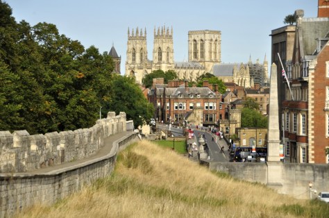


 In the fading years of the 19th century, Treasurer’s House was bought by eccentric industrialist
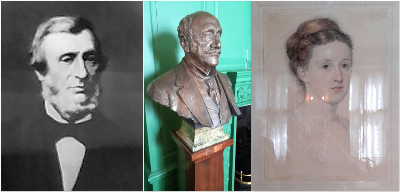


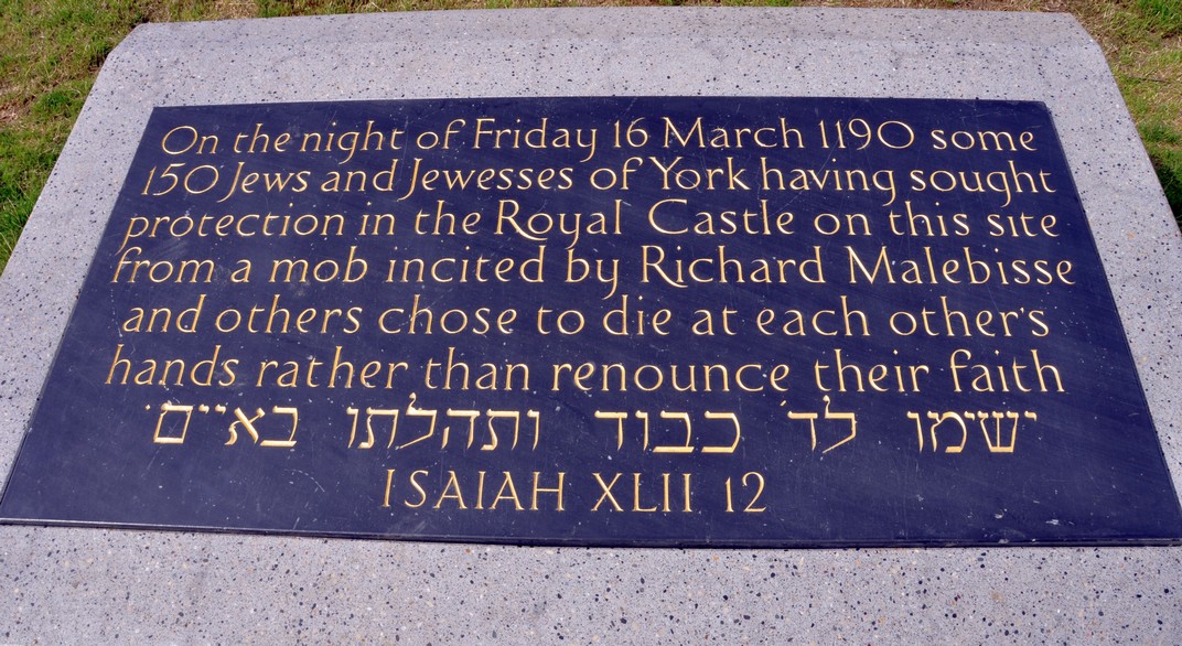
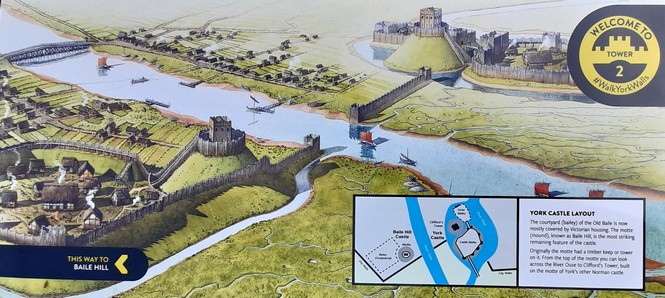

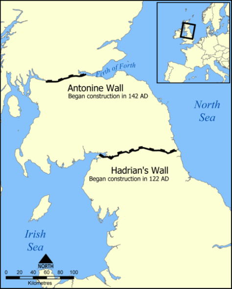
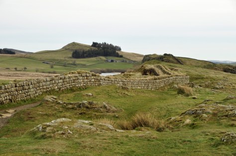
 And we can also wonder about the lives of the men (and women) who were stationed along the Wall and where they came from. It’s not just the physical legacy of the Wall (and other settlements around the country) but also the genetic legacy that the Romans left behind, in their offspring from relationships with local women, legitimate or otherwise. Romans didn’t just come from Rome, but from all corners of the empire even from the easternmost provinces of the Middle East and beyond. The ‘Roman’ genetic signature has obviously been diluted by successive waves of invasion into these islands.
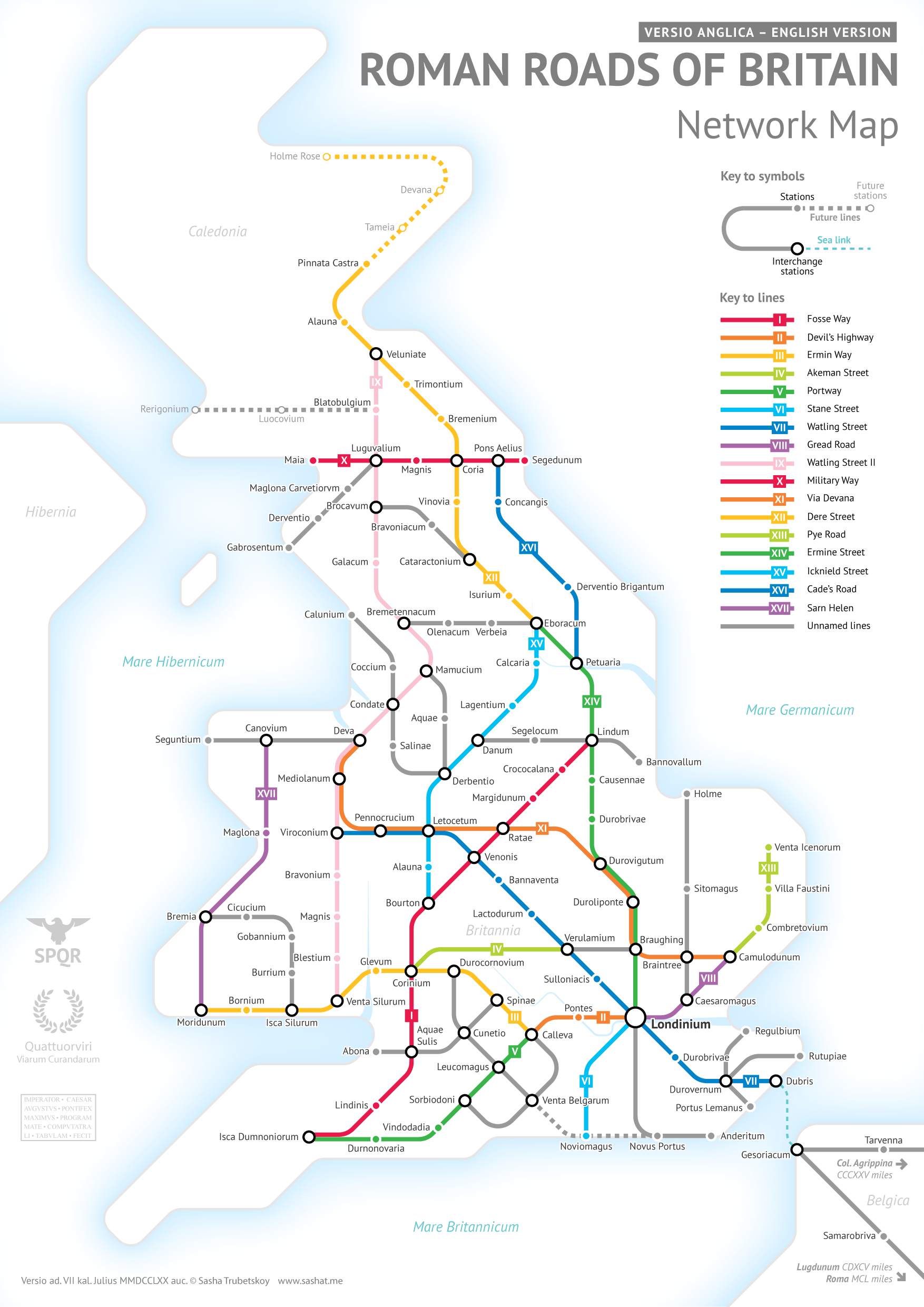
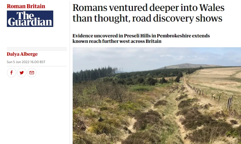
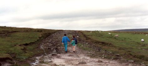
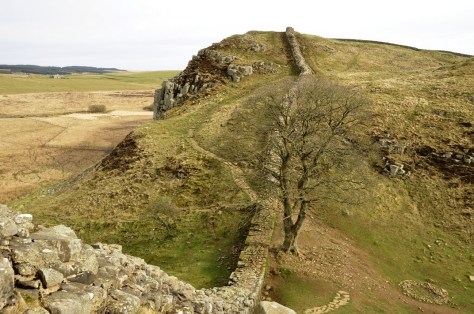
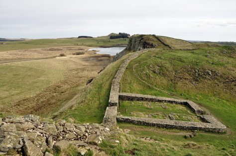
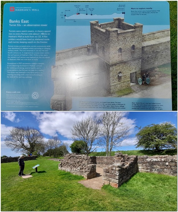


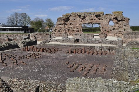

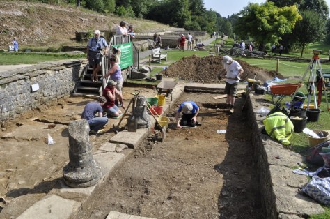


 The vandalism began in 1536. The landscape changed. Henry VIII threw his toys out of the pram, and ordered his officials to close down religious houses all over England, in what has become known as


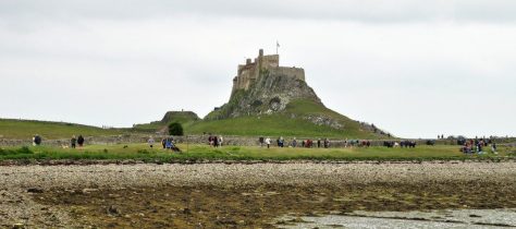


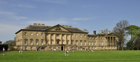


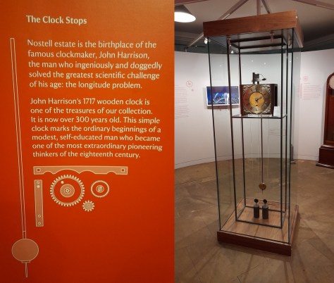


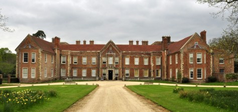
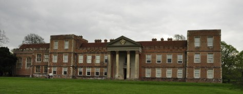


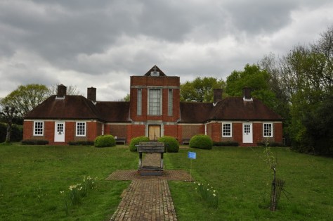


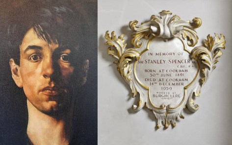
 at Sandham Memorial Chapel, Burghclere, Hampshire.")
")
 by Sir Stanley Spencer, CBE,RA (Cookham 1891¿ Cliveden 1959)")
")
")
")
")
")
 by Sir Stanley Spencer, CBE,RA (Cookham 1891¿ Cliveden 1959)")
 by Sir Stanley Spencer, CBE,RA (Cookham 1891¿ Cliveden 1959)")
")
")


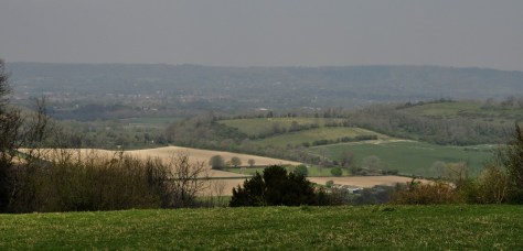
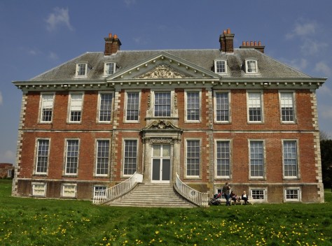
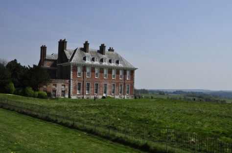


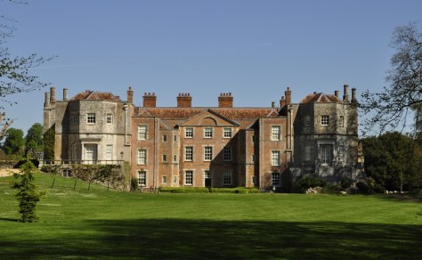
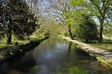


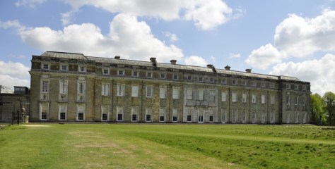
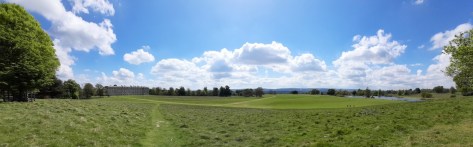


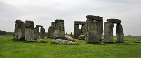
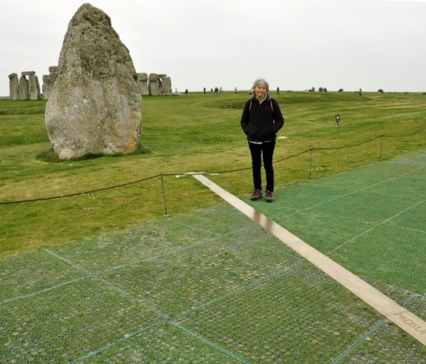
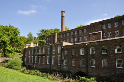


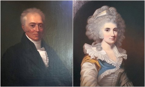


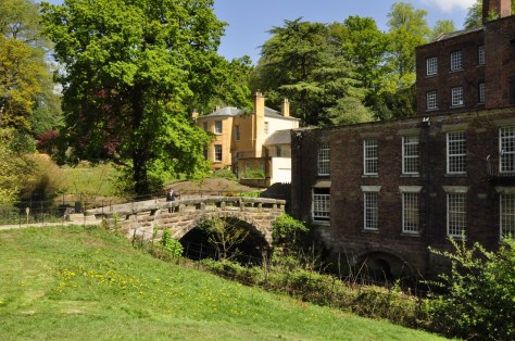
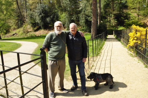


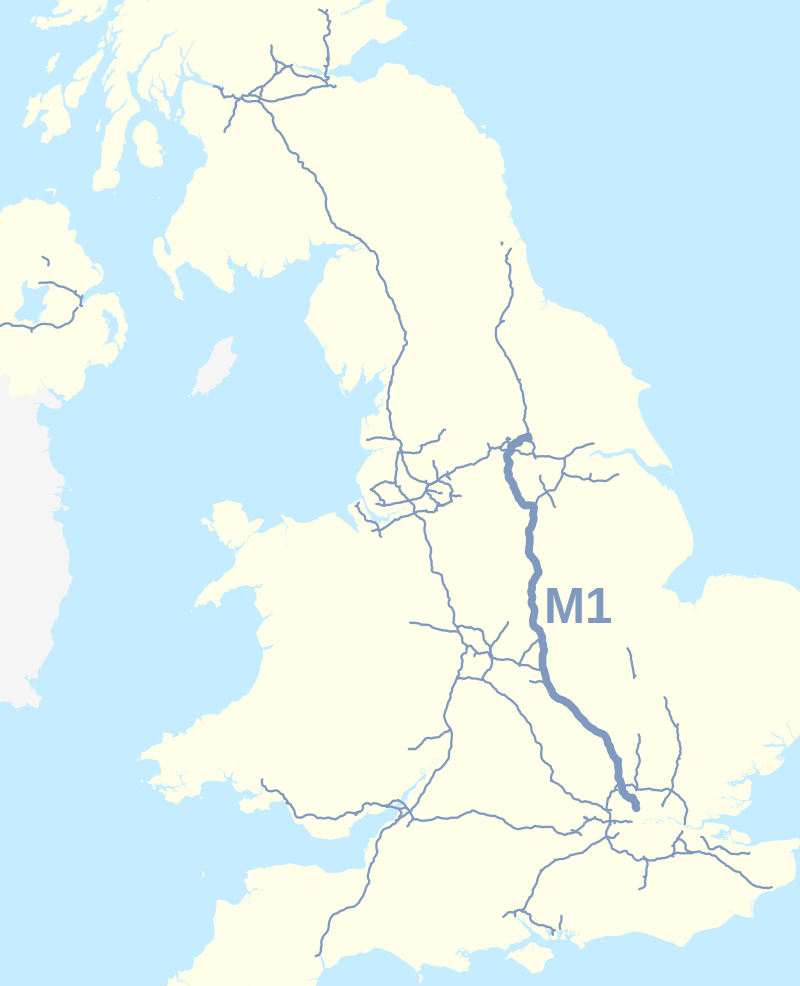
")


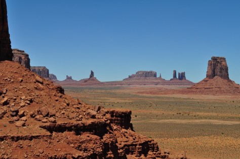


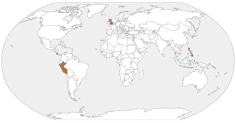


 My best friend Alan Brennan, a year younger than me, lived just a few doors further up Moody Street. But we didn’t go to the same school. I was enrolled at Mossley C of E village school, a couple of miles south of the town, like my two brothers and sister before me. Each weekday morning, my elder brother Edgar (just over two years older than me) and I took the bus together from the High Street to Mossley. Sometimes, in the summer, I’d walk home on my own (something that parents wouldn’t even contemplate today).


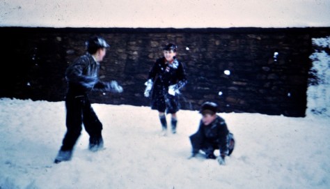


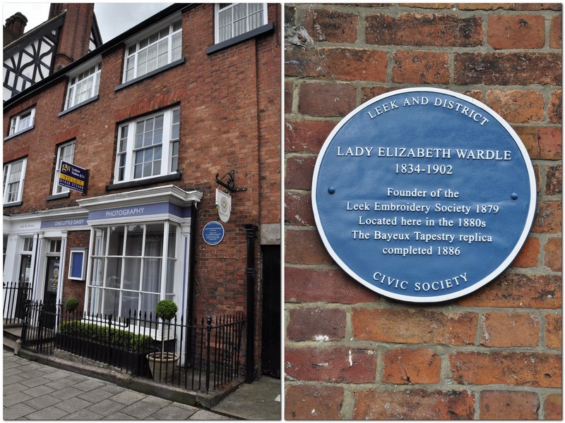


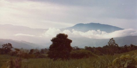


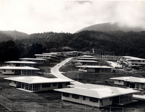


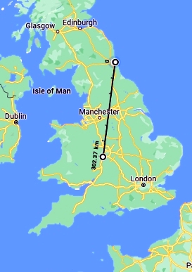 However, by the end of 2019 we had eventually decided to leave Bromsgrove and move north to Newcastle upon Tyne where our younger daughter Philippa and her family live. (Our elder daughter lives in Minnesota).


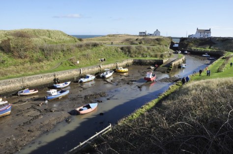


 Over the years, however, the Lincoln Highway was subsumed into the US numbered highway system, with much of the section between Pennsylvania and Wyoming becoming part of US 30. Nowadays, I-80 west of Chicago follows much the same route as far as I can determine, although in places to the south of US 30.
 Well, I’ve just finished reading
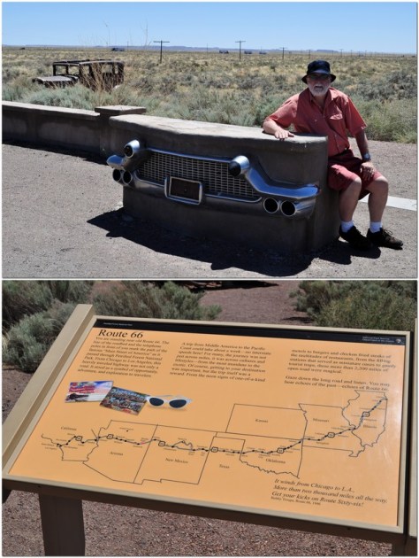
 Over recent weeks, Steph and I have been enjoying the latest series of


 Or the foundations of the


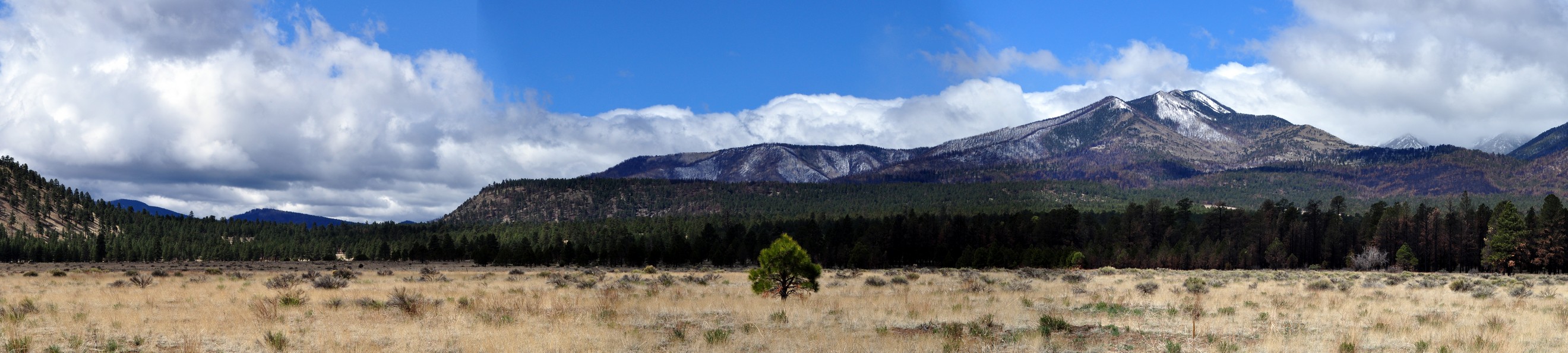


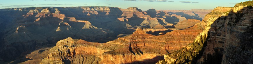


 In 1952, he returned to the UK, joining The University of Birmingham as a lecturer in the Department of Botany, but he returned to the Americas many times over the next four decades to collect potatoes. Awarded a personal chair in taxonomic botany in 1961, he became Mason Professor of Botany and head of department in 1967.


 One of Northumberland’s most famous sons was artist and naturalist


 As I approach my 73rd birthday, I find myself inevitably reminiscing about the places I’ve been, the wonders (both natural and man-made) I’ve seen, and the people I’ve met in the more than 60 countries (


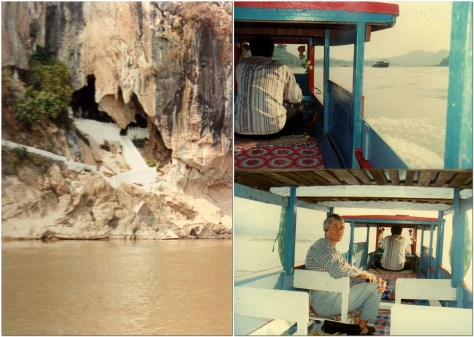


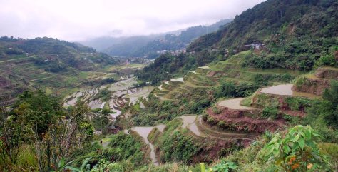

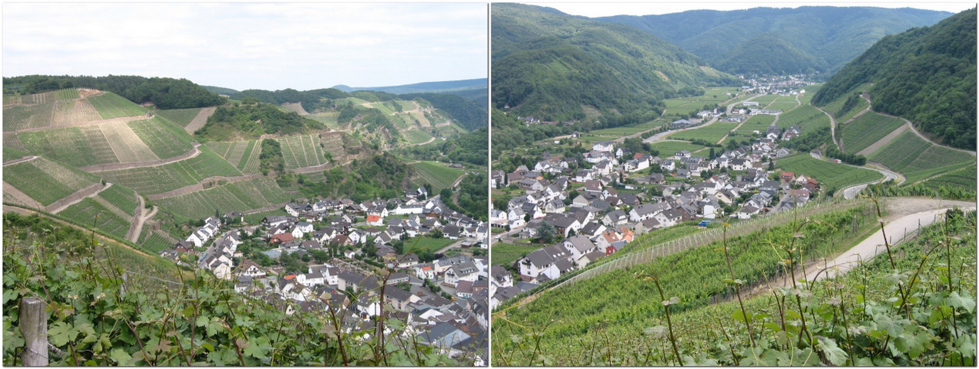


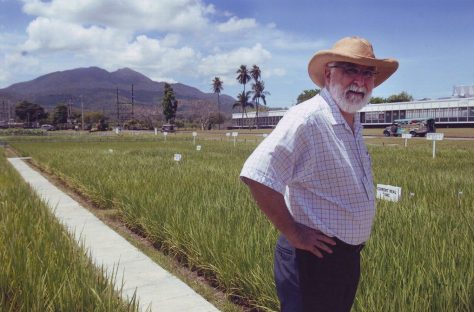
 Professor Brian Ford-Lloyd and I were graduate students together, colleagues at the University of Birmingham during the 1980s, and collaborating research scientists during the years at IRRI. Since we both lived in Bromsgrove, we would travel together into the university each day. We’ve published three books on genetic resources together. Following my retirement in 2010, Brian and I would meet up every few weeks to enjoy a pint of beer or three at our local pub, the Red Lion, in Bromsgrove where we both lived. Until that is I moved away from Bromsgrove to the northeast of England almost a year ago.


 Once the weather improved in May and June, and we could get out and about more regularly, Steph and I visited several abbeys and priories managed by English Heritage that dot the landscape of this northeast corner of England, including
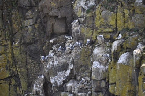


 About 7 miles northwest from Prudhoe, as the crow flies, the fortified manor house of


 We have visited 14th century


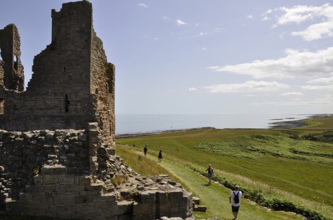
 For the past couple of months I’ve delved into Roman military fiction by British authors


 Much of our understanding of the history and archaeology of Hadrian’s Wall is down to one man in the nineteenth century:


 Chesters Roman Fort
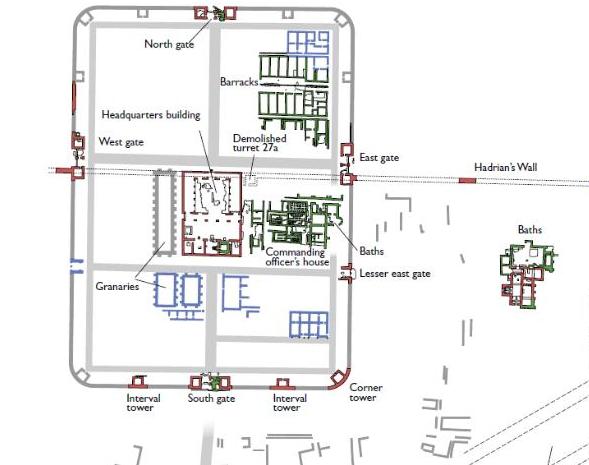


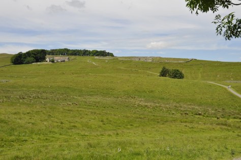

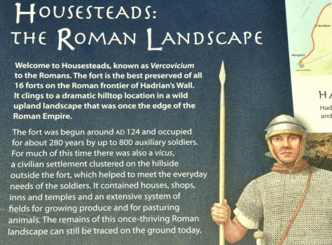 What is particularly impressive about Housesteads is its remote location. There are spectacular views from the fort over the surrounding Northumberland landscape, in all directions. And the fort and Hadrian’s Wall are intimately connected. It must have been an important site along the wall, in defence of the empire.
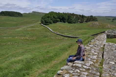
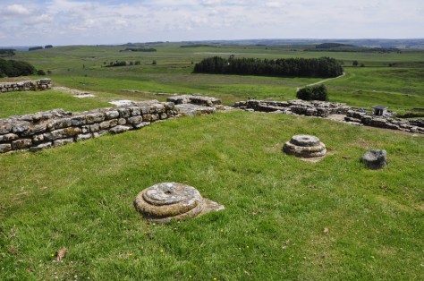


 28 June 1991. It was a Friday. Ten years and three months since I joined the University of Birmingham as a Lecturer in Plant Biology. And it was my last day in that post. A brief farewell party in the School of Biological Sciences at the end of the day, and that was it. I was no longer an academic.
 But I began to get itchy feet, and when the opportunity arose (in September 1990) for a move to the Philippines, to join the International Rice Research Institute (IRRI) as Head of the newly-established Genetic Resources Center (with its mandate to manage the world’s largest and genetically most important genebank for rice), I didn’t hesitate. Although, I have to admit, Steph and our daughters (Philippa was born in 1982) were less keen on the idea.
 Philippines with just under 24 hours to recover from my trip before the interview schedule began. In the end, I had less than four hours sleep, and was up for a 7 am breakfast meeting with Director General Klaus Lampe (right) and his three Deputy Directors General!
 I don’t remember too much about the trip from that point. Not because of over-imbibing, I hasten to add. It was just uneventful. On arrival in Manila, I was greeted by Director of Administration Tim Bertotti (right) and his Vietnamese wife who would be my ‘welcomers’ for the next few weeks, show me the IRRI ropes, so to speak, and be a couple I could turn to for advice. Having collected my heavy bags, and found the IRRI driver we headed south to Los Baños, where I stayed in the IRRI Guesthouse for the next month or so until the house allocated to me had been redecorated.

 I worked overseas for much of my career—just over 27 years—in three countries. For those who are new to my blog, I’m from the UK, and I worked in agricultural research (on potatoes and rice) in Peru, Costa Rica, and the Philippines, besides spending a decade in the UK in between teaching plant sciences at the University of Birmingham.
 I won’t deny that I have a particular soft-spot for Peru. It was a country I’d wanted to visit since I was a small boy, when I often spent hours poring over maps of South America, imagining what those distant countries and cities would be like to visit.


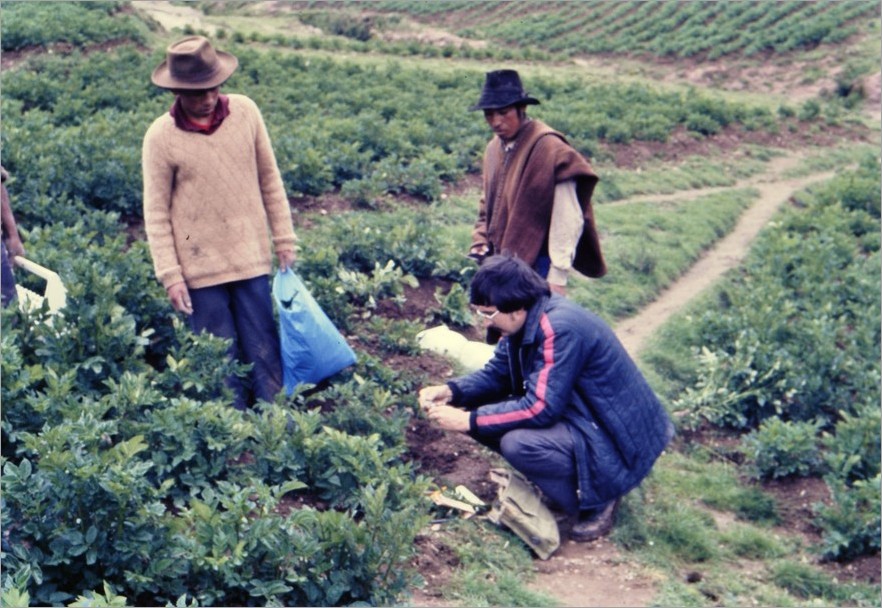


 But, after three years, it was time to move on, and that’s when we began a new chapter in Costa Rica from April 1976 a new chapter. Professionally, for me it was a significant move. I’d turned 27 a few months earlier. CIP’s Director General